Article

Aeolian Environment Regionalization in Xinjiang and Suggestions for Sand Prevention in Typical Areas

1
National Engineering Technology Research Center for Desert-Oasis Ecological Construction, Xinjiang Institute of Ecology and Geography, Chinese Academy of Sciences, Urumqi 830000, China
2
College of Resources and Environment, Xinjiang Agricultural University, Urumqi 830052, China
*
Authors to whom correspondence should be addressed.
Land 2024, 13(8), 1215; https://doi.org/10.3390/land13081215
Submission received: 22 July 2024 / Revised: 3 August 2024 / Accepted: 5 August 2024 / Published: 6 August 2024

Abstract

:
The Xinjiang region is prone to frequent and complex wind and sand disasters, which present a significant challenge to the sustainable development of local areas. This research uses multi-source data to analyze the spatial distribution of the aeolian environment in Xinjiang, establishes a four-level zoning scheme, and proposes recommendations for ecological management and engineering and control. Results indicate that (1) Xinjiang’s aeolian environment and its types exhibit spatial heterogeneity. The aeolian environment types display a high concentration in the eastern region and a low concentration in the western region. Furthermore, the aeolian environment types are concentrated in the basin region. Moreover, the aeolian environment types exhibit a meridional distribution pattern. (2) A four-level zoning system for aeolian environments in Xinjiang was developed, comprising two first-level zones, seven s-level subzones, 22 third-level wind zones, and 31 fourth-level subdivisions. (3) A structural model for a highway sand control system is proposed for aeolian environment types of subdivisions, including fixing-based, combined blocking and fixing, wind-blocking and sand-transferring, and combined blocking and fixing–transferring. The aeolian environment regionalization program proposed in this study can be a scientific reference for relevant departments in formulating and implementing sand prevention and control planning.

1. Introduction

Wind–sand activity is a complex surface process involving wind erosion, transport, and accretion, which can change the surface morphology and form unique wind–sand landscapes, and may cause wind–sand disasters [1]. Asia’s arid and semi-arid regions represent one of the largest dust sources in the world, with an estimated annual output of approximately 600 Mt of dust particles transported into the atmosphere [2]. This has been linked to many significant impacts on human health [3], marine biogeochemical cycles [4], nutrient supply to terrestrial ecosystems [5], and global climate change [6]. A wind–sand disaster is a natural phenomenon that can significantly impact the environment and human habitation. These disasters are characterized by a wide-ranging impact, strong seasonality, and a high degree of harm [7,8,9]. Xinjiang has long been subject to the destructive forces of wind and sand activities, which have posed a significant challenge to the safe operation of vital infrastructure in the region. The necessity for effective measures to mitigate the adverse effects of wind and sand disasters has become increasingly urgent [10].
The aeolian environment refers to natural environmental elements, such as climate and meteorology, geomorphology, and vegetation, among other elements, related to wind–sand activities and their combinations. The study of the aeolian environment has evolved from qualitative textual records to quantitative instrumental monitoring to comprehensive multi-source data analysis. This evolution has been accompanied by an expansion and deepening of the research content regarding spatial scales and time series.
Synthesizing domestic and international literature findings, research on aeolian environments can be divided into three categories: wind energy environments, sand and dust environments, and research that integrates both. The wind energy environment is typically investigated using only wind speed or measured data. Indicators such as wind speed [11], wind direction [12], and sand transport potential (RDP) [13] have been employed to characterize wind and sand activities, which are defined by a single source of data, a shorter time series, and a discontinuous record. Using these indicators to characterize the intensity of wind and sand activities at a single point is more appropriate. Using various data sources for sand and dust environmental research can provide insight into the range and intensity of actual sand and dust activities. Among the metrics commonly employed to indicate the intensity of modern wind and sand activities are the number of dust storm days [14], PM10 [15], aerosol optical thickness [16], and the extinction coefficient [17]. A series of dust indices based on spectral absorption differences have been generated, including the thermal infrared composite dust index [18] and the normalized difference dust index [19]. Yang et al. [20] analyzed the spatial and temporal changes in the risk of wind and sand disasters in the Sahel region from 2000 to 2020 and their main driving factors by comparing the applicability of different assessment methods and determining the optimal model. The analysis of wind and sand hazards was not conducted using multiple assessment methods in order to address the limitations of data availability and the complexity of the factors influencing these hazards. Wang et al. [21] assessed the risk of wind and sand disasters in Xinjiang from three aspects, based on the three-factor disaster theory: disaster-causing factors, the disaster-conceiving environment, and the disaster-bearing body, using subjective and objective methods.
For comprehensive research on aeolian environments, a multidisciplinary approach integrating climate, soil, topographic, and vegetation data can be employed. This approach enables the investigation of the complex interactions between wind and sand and their environmental effects. The resulting indices, such as wind erosion indices [22], climate erosivity indices [23], and dune movement indices [24], facilitate a quantitative understanding of these interactions. In addition, the regional aeolian environment types are typically described qualitatively based on expert knowledge, such as solid winds with more sand, weak winds with less sand, and so on. Although regional aeolian environmental conditions can be indicated to a certain extent, it is impossible to compare the differences between aeolian environment types in different regions due to the lack of a unified judgment standard. Furthermore, no quantitative research on aeolian environment types has been reported. Although there are no relevant research results on aeolian environment regionalization in China, much work has been done on zoning studies. These include “Evaluation of Desertification Disaster Hazard Zoning in Northern China” [24], “Ecological Zoning of Arid Regions in Northwestern China” [25], “Desertification Land Prevention and Control Zoning in Northern China (Outline)” [26], “Study of Desert and Desertification Land Zoning in Northern China Based on Remote Sensing Technology” [27], and “Study of Highway Desert Natural Zoning in China” [28]. Additionally, numerous studies focused on preventing and controlling desertification and the zoning of arid regions in China have been conducted; these include “Desertification Prevention and Control Zoning and Sub-zoning in Xinjiang Prevention and Control Technologies and Models” [29], “Zoning for Oasis and Desertification Regulation in Arid Regions of China” [30], and other zoning research results. These studies have integrated various factors, including geomorphology, climatic elements, geologic conditions, and desertification assessment results, to construct an evaluation index system and formulate zoning schemes with specific focuses. The existing studies have provided an essential reference for developing our study’s aeolian environmental zoning scheme.
Meteorological data are still predominantly employed to assess the intensity of wind and sand activities, and the resulting data can be utilized as a reference point. However, due to the significant regional variability in aeolian conditions, the results from individual stations can only partially capture the overall characteristics of the region. Consequently, there is a lack of long-term time series and high spatial accuracy in aeolian environment assessments based on remote sensing and re-analysis data. Second, the results of existing zoning research emphasize desertification and aeolian hazards, considering existing disaster-bearing factors. This quantification of the actual extent of the disaster can guide sand control and prevention work in Xinjiang to a certain extent. However, the data utilized in the existing studies are highly current, which results in a theoretically shorter update cycle for the zoning program and a shorter service timeliness. Given the research background and shortcomings mentioned above, in this paper, we have selected seven indicators: aeolian environment, RDP (Resultant Drift Potential), soil condition, vegetation cover, precipitation, and potential evapotranspiration to assess large-scale aeolian environmental results and proposed an aeolian environmental zoning scheme. Additionally, we suggest targeted countermeasures to be implemented for sand control and prevention work in typical areas. The object of this study is (1) to clarify the spatial distribution characteristics of the aeolian environment in the whole region of Xinjiang; (2) to formulate a zoning program for the aeolian environment in Xinjiang; (3) to put forward targeted ecological management measures and engineering configuration models. This research provides a scientific basis for realizing sustainable and economic protection projects.

2. Materials and Methods

2.1. Study Area

The study area is the Xinjiang Uygur Autonomous Region (Figure 1), which encompasses 1,664,900 km2 and is situated in the hinterland of the Asian and European continents. Its coordinates are 73°30′–96°23′ E and 34°20′–49°10′ N. Xinjiang’s geographic location and geomorphological pattern have resulted in the formation of a typical temperate continental arid climate. This climate is characterized by scarce rainfall and strong evaporation, with an average annual precipitation of 141.8 mm across the entire region. Additionally, there is a vertical differentiation of soil moisture with elevation changes and significant differences in the landscape types and patterns between the mountainous areas and basins [31]. The topography of Xinjiang is characterized by a landscape of basins and mountains, collectively referred to as the “three mountains and two basins”. The Altai Mountains are located in the northern region, while the Kunlun Mountain system is situated to the south. The Tianshan Mountains span across the central area of Xinjiang. Xinjiang is geographically divided into two distinct regions: the Tarim basin in the south and the Junggar basin in the north.
The arid zone of Xinjiang encompasses an area of 1.227 million km2 and has developed several significant wind-formed landforms. The Gurbantunggut desert, the Taklamakan desert, the Kumtag desert, and the Hashun Gobi are regions with strong winds and abundant sources of sand, which provide the dynamic conditions and material basis for wind and sand activities. The coupling effect of the nature of the subsurface and atmospheric circulation in the region is extremely complex, resulting in significant spatial differences in the aeolian environment [32]. Consequently, the wind and sand control measures need to be adjusted accordingly. For example, it has been recommended that, in the area of quicksand gathering, more grass squares and high vertical sand barriers can be used to impede the forward movement of the sand source [33], and the Gobi region can be set up to avoid the accumulation of the sand source in the downwind project [34]. The frequent occurrence of sandstorms in Xinjiang has posed a significant threat to the safe operation of engineering facilities; for instance, the sand burial phenomenon on numerous national highways traversing the Tarim basin has become a considerable concern [35].

2.2. Data Sources

This research employed a multi-source approach, integrating data from various sources, including soil and re-analysis data (Table 1). The soil data were obtained from OpenLandMap (https://gitlab.com/openlandmap, accessed on 9 June 2023), which provides continuous-type raster data with a spatial resolution of 250 m at six standard depths (0, 10, 30, 60, 100, and 200 cm). The R2 values for the simulated soil organic carbon content, soil water content, and soil sand content relative to the measured values were 83.4%, 95.5%, and 90.8%, respectively. Meteorological variables include rainfall, potential evapotranspiration, and wind speed. The rainfall and potential evapotranspiration data were obtained from TERRACLIMATE with a spatial resolution of 2.5′ and high accuracy. The Pearson’s correlation coefficient of the precipitation, using GHCN (Global Historical Climatology Network) data, was 90%, with an average absolute error of 9.1%, and that of the potential evapotranspiration data from FLUXNET was 77%, with an average absolute error of 8.3% [36]. The wind speed data were derived from ERA5 re-analysis data, which had a temporal resolution of hours and a spatial resolution of 0.1°. These data exhibited a high degree of fit to the measured data from meteorological stations, and are more applicable than the NECP data in the Chinese region [37]. The normalized vegetation index (NDVI) data were obtained from MOD13A2 with a global precision of ±0.025. NDVI values less than 0 were assigned null values to exclude ice/snow regions. To ensure the timeliness of the results, the mean values of rainfall, potential evapotranspiration, RDP, and NDVI from 2001 to 2020 were calculated and subsequently used in the modeling process.

2.3. Research Methodology

The aeolian environment can be quantified by combining wind power strength and sand abundance. The RDP indicates the region’s potential sand transport capacity, which can be used to characterize the strength of wind power. Soil conditions, vegetation cover, precipitation, and potential evapotranspiration indirectly affect sand abundance. The land-use type quantifies the risk of aeolian dispersion in the region. These seven indices can comprehensively characterize the abundance of sand sources (Figure 2).

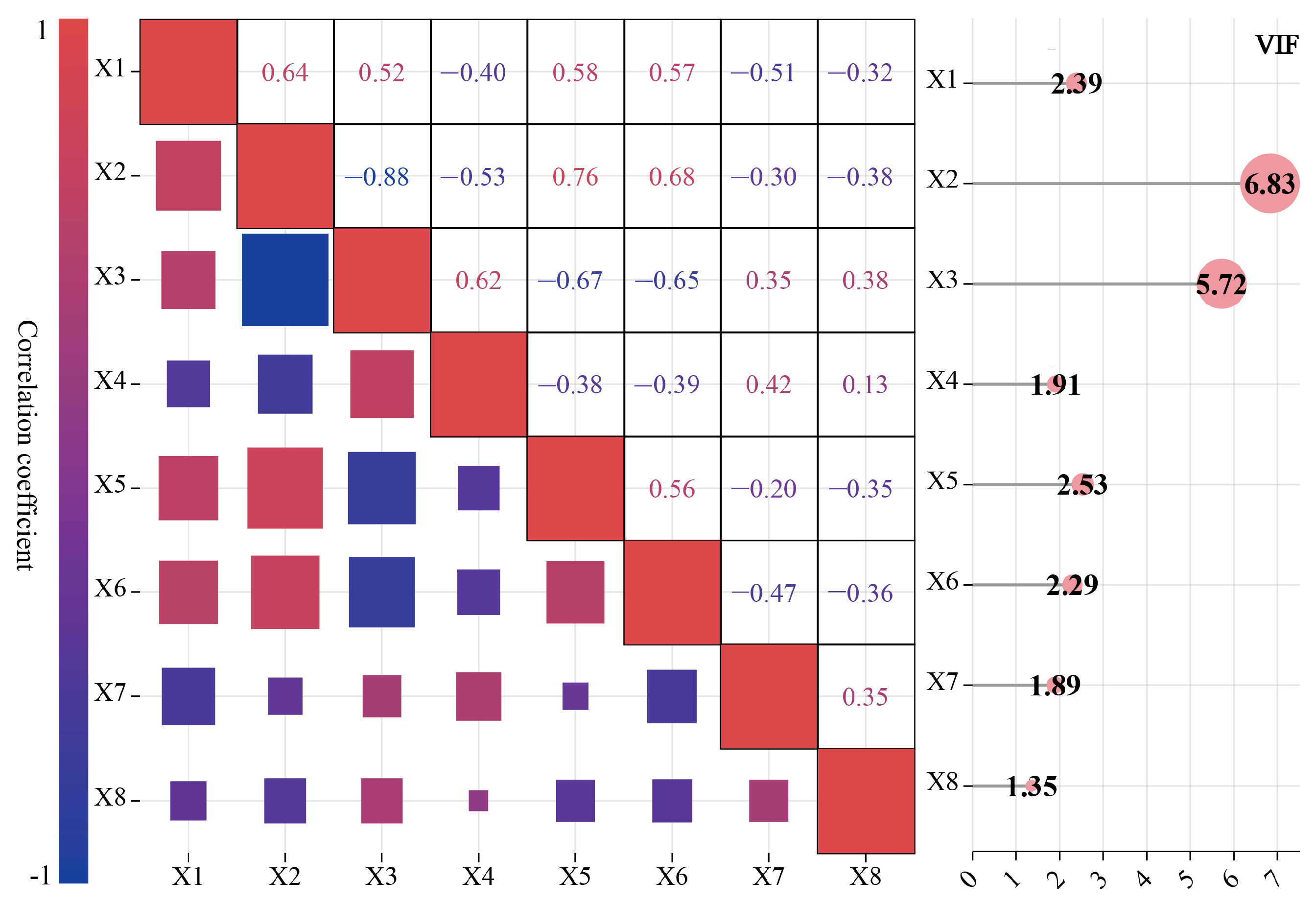
2.3.1. Diagnosis of Multicollinearity in Evaluation Indicators

Before evaluating the model, it is essential to diagnose multicollinearity, a crucial aspect of the analysis [38]. Correlations exist between the indicators, and they exert influence upon one another. The covariance of the indicators will affect the accuracy of the evaluation results. Therefore, assessing factor independence and eliminating multiple covariances are prerequisites for obtaining scientific evaluation results. The variance inflation factor (VIF) can be employed to ascertain the extent of multicollinearity between evaluation indicators.
V I F i = 1 1 R i 2 ,
Here, VIFi is the variance inflation factor of indicator i, and Ri2 is the coefficient of determination of indicator i. According to the VIF value, the covariance was classified as no covariance (0 < VIF ≤ 5), weak covariance (5 < VIF ≤ 10), moderate covariance (10 < VIF ≤ 100), and severe covariance (VIF > 100), according to the VIF value. Following the diagnosis of multiple covariance (Figure 3), the VIF values of all indicators were found to be less than 10, indicating that none of the indicators exhibited severe covariance. This suggests that the indicator system is both scientific and reasonable.

2.3.2. Wind Power and Sand Source Abundance Assessment Model and Classification of Aeolian Environments

The natural disaster risk assessment method serves as a guiding framework for the construction of the sand abundance index in this study. In light of the scientific rigor, logical coherence, and simplicity of the evaluation model, this study employs the “two-factor theory” [39] and integrates the seven aforementioned indicators to characterize regional sand abundance comprehensively. Each continuous indicator is classified into five levels using the natural breakpoint method. All indicators are treated as positive, with larger values indicating a higher risk of wind–sand dispersion.
s a n d m = o r g a n i c × w a t e r × s a n d × L U C C × N D V I × p r e × p e t 7 ,
Here, sandm is the sand source richness class, organic is the soil organic carbon content class, water is the soil water content class, sand is the soil sand content class, LUCC is the land-use type class, NDVI is the NDVI class, pre is the precipitation class, and pet is the potential evapotranspiration class.
D P = j = 1 n V t 2 × ( V i V t ) × t i ( t i = 1 N ,   V i V t )
The DP (Drift Potential) variable represents the sand transport potential, and the critical starting wind speed (Vt) is set to 6.0 ms−1 [40,41]. The variable Vi denotes the wind speed of the ith observation, while N represents the total number of 1a observations. Finally, n denotes the number of sand-starting winds.
Windp = RDP,
where Windp is the wind-dynamic condition and RDP is the synthetic sand transport potential rating.
A T = 10 × w i n d p + s a n d m ,
Here, AT is the type of aeolian environment, and the wind-dynamic conditions and sand abundance classes are divided into five levels, where levels 1, 2, 3, 4, and 5 correspond to the degree of wind or sand abundance as follows: no or light, light, moderate, medium, and very heavy, respectively. The wind power condition level is multiplied by 10 and added to the sand source richness level, resulting in a combined value for wind power and sand source. This value is then used to determine the AT level. In theory, there are 25 distinct aeolian environment types, with the first indicating the strength of the wind power and the second indicating the amount of the sand source. The greater the value of the aeolian environment type, the more pronounced the trend of wind power and sand source abundance. The lowest wind power and lowest sand source abundance are observed at a value of 11, while the highest wind power and highest sand source abundance are observed at 55.

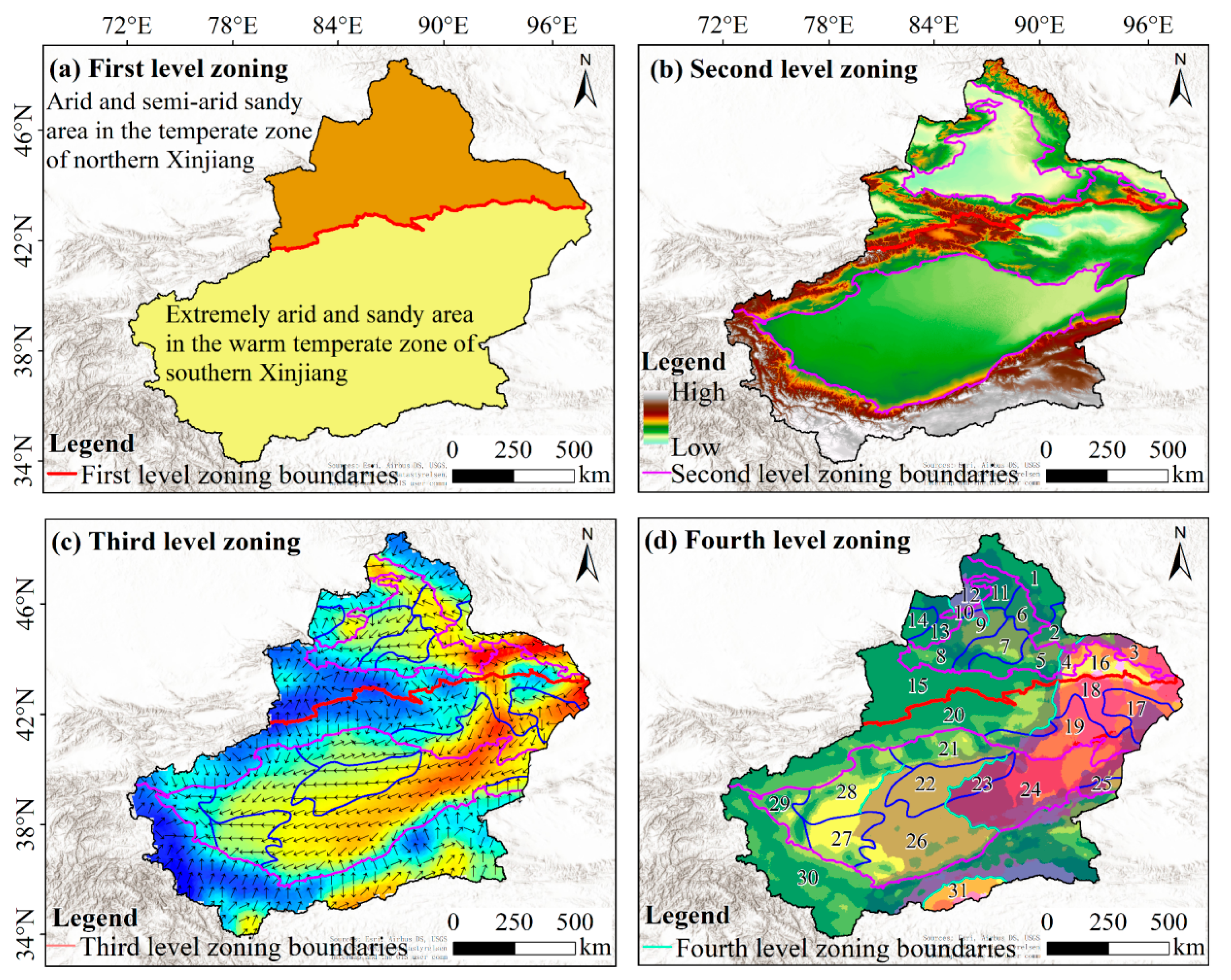
2.3.3. Aeolian Environment Regionalization in Xinjiang

Zoning Objectives

In light of the considerable variability in the spatial distribution of aeolian environments across the entire Xinjiang region and the multitude of complex and diverse underlying causes, a scientific, comprehensive, integrated, and coordinated zoning approach represents a fundamental prerequisite for the effective implementation of disaster prevention and mitigation measures. Consequently, aeolian environment zoning was established when the specific characteristics of the aeolian environment were elucidated, which fully integrated considerations of the natural climate, geomorphological patterns, and geological conditions. This serves as a scientific reference and practical guidance for relevant departments in the formulation of sand prevention and sand control planning.

Zoning Principles

(1) The principle of comprehensive evaluation indicators is a fundamental tenet of scientific inquiry. To formulate the aeolian environment zoning scientifically and reasonably, it is necessary to select many comprehensive and objective evaluation indices. This ensures that the regional wind energy environment and sand and dust environment are adequately characterized. To do this, it is necessary to study the existing literature and consider expert opinions [42].
(2) The principle of similarity of aeolian environment. Under the first law of geography, all things are correlated, wherein similar things are more closely related [43]. Given the similarity of vegetation, soil, climate, geomorphology, and other conditions within a given area, it can be reasonably assumed that the aeolian environment within the same control area will also exhibit similar characteristics.
(3) The principle of consistency of sand prevention measures. It is recommended to adhere to the principles of sand prevention and sand control according to local conditions and hazards, consider the similarity of the aeolian environment in the region, determine the main characteristics of the elements of the aeolian environment within the zoning area, grasp the critical contradictions of sand prevention and sand control, and implement the same mode of sand prevention and configuration within the same zoning area. This helps relevant departments to carry out their work in a unified manner.
(4) Expert opinions and the principle of consistency of causes. The same zoning unit should have a high degree of similarity in the conditions for the occurrence and development of wind and sand activities, the mode and intensity of wind and sand activities, and wind and sand prevention and control measures, which is an important factor to ensure the scientific nature of zoning.
(5) The principle of comprehensive factors. Many factors are related to the aeolian environment. To make an extensive and correct diagnosis of regional differences, various related factors should be analyzed comprehensively as much as possible to avoid generalization or the omission of important information.
(6) The principle of dominant factors is crucial in zoning for wind and sand prevention and control. It emphasizes the importance of identifying the main contradictions when analyzing relevant problems. This process of determining the dominant factors in the aeolian environment facilitates the development of targeted and effective response or prevention strategies.

Zoning Methodology

This study presents a methodology for determining zoning boundaries at all levels, based on zoning principles and evaluating the relevant indices to create an aeolian environment zoning system. The zoning system presented in this study is divided into four levels of zoning. The first-level zoning is divided into the temperate arid and semi-arid wind and sand zone on the northern border and the warm temperate extreme arid wind and sand zone on the southern border [44]. The natural climate and geomorphological conditions influence the regional aeolian environmental conditions and the degree of wind and sand hazards. These conditions vary considerably across the region and, according to the “Geomorphology of Xinjiang and its Environmental Effects”, subzones were further divided based on the first-level zoning. The Altai–Beitashan subzone, the western Dzungar Mountain subzone, the Dzungar basin subzone, the northern slope of the Tianshan Mountains subzone, the southern slope of the Tianshan Mountains subzone, the Tarim basin subzone, and the Kunlun Mountains–Altshanshan Mountains subzone constitute the subzones of the Kunlun Mountains–Altan Mountains subregion.
Based on the ERA5 re-analysis data, the annual dominant wind direction in Xinjiang was employed as the foundation for the division of the third-level zoning, with the boundaries of the third-level zoning determined based on the second-level zoning. The nomenclature of the third-level zoning is based on the combination of a “middle (small) geographic unit name”, a “geomorphology type”, and a “dominant wind direction”. This approach highlights the geographic location, geomorphology type, and dominant wind direction. The fourth-level zoning was established based on the third-level zoning under the principles of comprehensiveness, similarity of aeolian environments, and consistency of sand prevention measures, considering the type of regional aeolian environments and the relevant indices characterizing these environments. The nomenclature of the fourth-level zoning system is based on the principle of the “middle (small) geographic unit name” + “geomorphology type” + “dominant wind direction” + “aeolian environment type”. This approach allows for a more detailed and nuanced representation of the regional aeolian environment, extending beyond the third-level zoning system.

3. Results

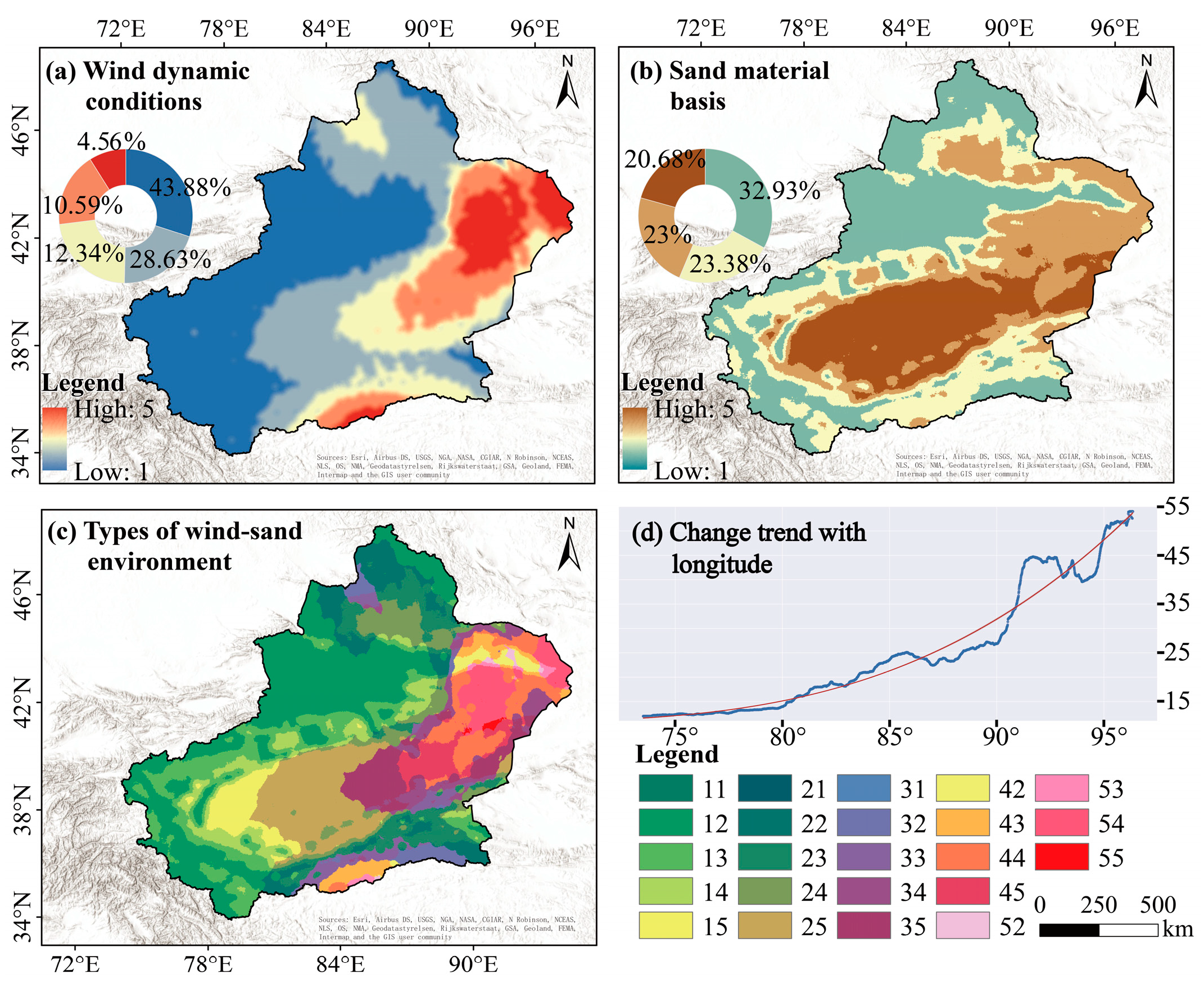
3.1. Spatial Distribution of Aeolian Environmental Types in Xinjiang

The mean annual RDP values across the entire Xinjiang region range from 0 to 1176 VU, exhibiting a spatial distribution characterized by high values in the eastern region and low values in the western region, as well as high values in the basin and low values in the mountains (Figure 4a). The wind energy environment in the area is dominated by low-energy conditions (RDP< 200 VU), which account for 91.77% of the total. Medium-energy conditions (200 ≤ RDP ≤ 400 VU) and high-energy conditions (RDP > 400 VU) collectively account for 8.23% of the total. The medium- and high-energy areas are primarily located in the Santang–Nao Mao low hills, Tuha basin, Lop Nor poor-quality salt flats, eastern Tarim basin, northern middle-eastern Kunlun Mountains, and significant wind areas.
The sand source richness is the material source of wind–sand activities, and its spatial heterogeneity is closely related to land-use types (Figure 4b). The low value of sand source abundance is mainly distributed in mountainous areas, oases, and along rivers, with high vegetation cover, good moisture conditions, and soil stability. The wind and sand control projects in these places are relatively well constructed, lacking the sand material required for wind and sand activities. The types of sand corresponding to the high value of sand source abundance are flowing semi-fixed sand and fixed semi-fixed sand. The abundance of sand sources provides a substantial material basis for wind–sand activities, yet frequent human disturbances exacerbate the desertification process. The natural breakpoint method divides the sand source richness value into five levels, and the overall sand source grade is divided into two categories, levels 2 and 3, which account for 32.93%, 23.38%, 23%, and 20.68%, respectively, of the total image elements.
The quantitative characterization of the spatial distribution of wind–sand environments can be achieved by analyzing the type of aeolian environment. Complex geomorphological patterns result in significant regional aeolian environmental variations. These variations are meridional, with an overall increasing trend observed with increasing longitude (Figure 4d). The high value of the aeolian environment type corresponds to regions with stronger winds and richer sand sources. These are mainly located in the Santang–Nao Mao low hills, the Hashun Gobi, Kuruktag, the eastern Taklamakan desert, and the northern part of the middle-eastern Kunlun Mountains. The regional subsurface is mostly the Gobi and the flowing desert, and strong wind is a typical feature of this region. In contrast, the central and western Taklamakan desert and the Gurbantunggut desert have many sand sources, but the wind force is drastically scaled down compared with the leading wind areas. Consequently, the aeolian environment type value is low. Areas with low values of the aeolian environment type are associated with low values of sand abundance, where soil moisture is a dominant factor.

3.2. Aeolian Environmental Regionalization Results

The results of aeolian environmental regionalization at various levels are presented in Figure 5. Following the objectives and principles of zoning, the methodology employed, and expert opinions [42], two first-level zones were delineated using the Tianshan Mountains as a demarcation line. Furthermore, 7 s-level zones were established based on the large geomorphologic unit of Xinjiang, 22 third-level zones were delineated based on the dominant wind direction, and 31 fourth-level zones were delineated based on the type of aeolian environment (Figure 5). The names of the zones at each level are provided in Table 2.

4. Discussion

4.1. Causes of Spatial Differentiation of Aeolian Environments in Xinjiang

To ensure the sustainability of critical infrastructure, systematically clarifying the causes of the spatial differentiation of the aeolian environment in Xinjiang can provide a theoretical basis for developing sand prevention and hazard sand control. In general, the unique topographic and geomorphic patterns of Xinjiang and the aeolian environment have a long-term mutual feedback effect, which is the driving force for the formation and development of the aeolian environment.
The landforms of Xinjiang are distinguished by significant undulations, with altitudes ranging from −155 to 7530 m. The “three mountains and two basins” are the prevailing characteristics of the landforms in Xinjiang. Atmospheric circulation and the mountain–basin system influence Xinjiang’s aeolian environment. The Tibetan plateau, the Pamir plateau, and the Tien Shan Mountains are the root causes of the basin’s extremely arid climate and desert formation [45], and the westerly circulation system and the Mongolian high-pressure system are external factors that influence wind and sand movement [46]. The mountain–basin system in Xinjiang is distinctive, resulting in a complex and diverse near-surface atmospheric motion. The Tian Shan obstructs the entry of the Arctic Ocean airflow, while the Tibetan plateau and Kunlun Mountains impede the entry of the Indian Ocean airflow [47].
Throughout the year, mainly westerly airflow enters the Junggar basin through the mountain passes in western and northwestern Xinjiang, which then arrives at the junction between the eastern end of the coccyx of Bogda Mountain and the western end of Barkun Mountain and penetrates deeper into the Tarim basin through the eastern, western, and central irrigation regions [48]. This is an essential multiple wind region and a critical wind power base construction area. Sand supply is the most important condition in the desertification process, and Xinjiang is rich in sandy materials, with large areas of desert and Gobi [49]. In conclusion, Xinjiang is characterized by an aeolian environment, influenced by the geomorphic pattern determined by the mountain–basin system, the widely dispersed sediments in the basin, and the atmospheric circulation. In addition, the aeolian environment promotes the development and evolution of geomorphological patterns. The two significant basins in Xinjiang are characterized by almost opposite directions of topographic dip and a dominant wind direction [48]. The direction of the topographic dip determines the direction of fluvial sediment transport [50], while the dominant wind direction determines the direction of wind-formed sediment transport [51]. Therefore, the peculiar tectonic genesis and atmospheric circulation patterns in Xinjiang determine the complex geological macrocycle processes, confirming the complexity and multi-source origin of subsurface sand materials.

4.2. Countermeasures against Sand Prevention in Typical Aeolian Environment Regionalization

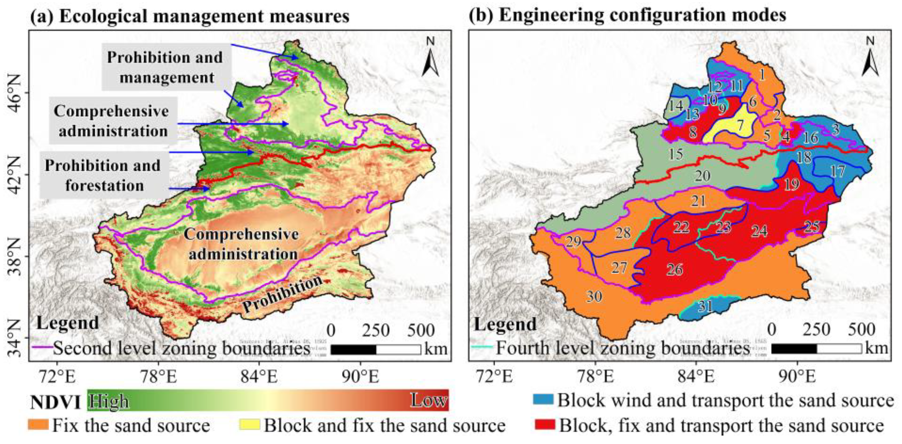
4.2.1. Measures for Ecological Management in the Subregion of Aeolian Environments

Desert areas have developed distinctive geomorphological landscapes and perform particular ecological service functions within the ecosystem. To address the specific characteristics of the regional aeolian environment, a series of environmental management measures have been proposed for each secondary zoning area (Figure 6a).
(1) The Altay–Beitashan subregion should be mainly protected by conservation and management. The subarea of the Altay Mountains is the main body, characterized by mountain elevation, precipitation, and vegetation cover; the overall wind erosion activity is weak and mainly occurs in the foothills and hilly plains, which should be protected by natural vegetation, for which artificial auxiliary restoration of vegetation is the most important activity. At the same time, the wind power in the low hills of Santang–Nao Mao Lake is extreme, wind erosion is intense, and, due to the recent construction of a photovoltaic power plant on the lower bedding surface of the intrusion, it has further intensified. Therefore, attention should be paid to the setting of the local conditions when developing sand prevention and sand control engineering measures.
(2) The Junggar basin subregion has a complex sandy and windy environment with various land-use types, and comprehensive management should be the main focus. The Gurbantunggut desert dominates this subregion. It includes the Erqis River basin and the urban agglomeration on the northern slope of Tianshan Mountain, among other features. At the same time, unsustainable human economic activities are the biggest threat to the relatively stable ecosystem, and the fragile biological crust plays a significant role in preventing the land from becoming sandy. Therefore, the reclamation of sandy areas and the ecological restoration of fallow lands, the improvement of oasis protection forests and the construction of technical and prevention systems, the strengthening of the reconstruction of degraded vegetation on the periphery of oases, and the reclamation of activated sand dunes on the edges of deserts should be accelerated in response to major regional conflicts.
(3) The overall soil and water conditions in the mountainous subregion of western Junggar are relatively good, and the primary focus should be on sealing, conservation, and management. The Tacheng Mountain basin is the center of the mountains, and the overall vegetation cover is high; the basin plain precipitation reaches up to 300 mm, the oasis protection system is perfect, the risk of land desertification is low, and the overall conservation and management of conservation are good. On the other hand, the wind power in the Tacheng old wind gap zone is extreme, and windy weather of grade 8 or above can reach a frequency of 180 days a year; therefore, the critical task in this region is wind prevention.
(4) The subregion of the northern slopes of the Tianshan Mountains and the subregion of the southern slopes of the Tianshan Mountains have high precipitation and various landscape types, and they should be closed for conservation and afforestation. The Tianshan is a “wet island” in the arid region of northwest China, and the northern Tianshan is particularly prominent, with extensive forests and grasslands, ice and snow cover, and better soil moisture conditions. Although the moisture conditions in southern Tianshan are worse than those in northern Tianshan, the risk of land desertification is low in most parts of the region, without anthropogenic disturbances caused by industrial and mining development and infrastructure construction. Wind erosion and sand deposition, on the other hand, are prevalent in the plains of the intermountain basin. This subregion contains national and autonomous region-level prohibited development zones, forest parks, scenic spots, and so on. Closure, conservation, and afforestation are long-term tasks in the region.
(5) The Tarim basin subregion is characterized by extensive deserts and widely varying aeolian environments, and comprehensive management should be the focus. Taking the Taklamakan desert as the core, there is a 1400 km aeolian front in the south, which connects several oases and is a crucial area for sand prevention and control; the Tarim River basin in the north is an irreplaceable ecological corridor; and in the east and west, there are channels for the gusty circulation of the basin to enter and play a role in the deserts and their surroundings. Therefore, protecting the oasis in the region requires reforestation and management, the treatment and repair of river outlets, the care and maintenance of river corridors, and sealing and protection of the deserts.
(6) The Kunlun Mountains–Altun Mountains subregion should be mainly closed for conservation. More than 50% of the area of this subregion is covered by the Gobi cold desert and barren rocks, including the Kumukuli desert and the Bulunkou desert. The Arjinshan Nature Reserve, the Middle Kunlun Mountains Nature Reserve, and the Tashkurgan Precious Animals Nature Reserve have been established in this subregion, and the degree of human disturbance is relatively low; however, due to the scarcity of water resources and the unfavorable conditions of high and low temperatures, the region’s natural restoration capacity is weak, and the implementation of closure and conservation measures is the key to realizing sustainable development.

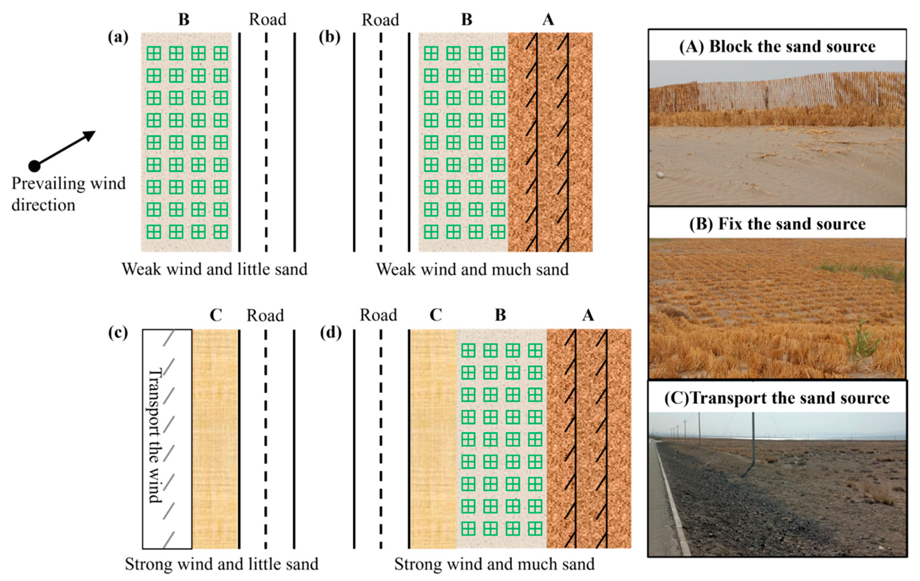
4.2.2. Structural Models of Sand Control Systems for Roads in Sandy Areas

Xinjiang is a vast area with frequent occurrences of sand and wind activity, and sand and wind disasters have become the primary threat to the safe operation of infrastructure. However, different types of infrastructure (railroads, highways, irrigation canals, oilfield bases, and so on) have different disaster conditions, sand prevention priorities, and sand prevention measures. As such, the sand prevention and control model is not universally applicable; instead, it should be developed for specific disaster objects to set up preventive measures according to the hazards and the structure of the sand prevention system according to the local conditions. Highways play a pivotal role in the transportation of resources, movement of people, emergency security, economic connectivity, and other critical functions. Therefore, they are a primary focus of sandstorm prevention and control efforts. The technical specifications of highways are exacting, the types of ancillary facilities are numerous, and the factors precipitating regional wind and sand disasters are intricate and multifaceted. Consequently, it is imperative to propose a regional highway sand prevention system structure model to mitigate highway wind and sand hazards.
The structure model of the highway and prevention system should be oriented to different types of aeolian environments in order to solve the principal contradiction flexibly, combining the elements of “blocking, fixing, transporting, and guiding” to achieve the goal of practicality and economy. A sand prevention system structure model is proposed based on the assessment results of the aeolian environment types (Figure 7). The aeolian environment zoning results can inform the formulation of a sand prevention system structure model, with the aeolian environment types in the fourth-level zoning serving as a reference. In the case of weak wind and less sand (Figure 7a), sand prevention measures such as the grass square lattice can be primarily implemented in nature. This type of sand prevention measure can block the transportation of sand material and ensure a long-term effect.
In the case of a weak aeolian environment (Figure 7b), where the wind is weak but the sand source is abundant, a combination of blocking and fixed sand control measures can be employed. This may include vertical sand barriers and grass squares, among other options. In general, blocking-type sand control measures are set up outside to prevent the sand source from moving forward, while fixed-type sand control measures prevent an area from becoming covered and, in contrast, are set up on the inside of an area. In the case of a strong wind and a limited sand source (Figure 7c), it is particularly challenging to accumulate sand in the area in question. In such instances, it is advisable to prioritize wind-blocking and sand-transferring control measures, such as installing a downward wind-guiding project. In the case of a strong aeolian environment (Figure 7d), characterized by a strong wind and abundant sand sources, the aeolian environment is complex and subject to change. In light of the specific circumstances of the region, the sand prevention measures of blocking, fixing, and guiding should be employed flexibly.

4.3. Enlightenment

Desertification represents a significant global ecological, environmental, and socio-economic challenge. It not only results in the deterioration of the ecological environment but also contributes to a reduction in agricultural productivity and incomes, ultimately impacting the normal production and quality of life of people. The countries of the Sahel (Senegal, Mauritania, Mali, Burkina Faso, Niger, Nigeria, Chad, Sudan, South Sudan, Ethiopia, and Eritrea), which collectively represent a population of nearly 500 million people, are subjected to the hot and dry winds of the Sahara desert on a year-round basis. This makes them the most drought-prone region in the world. The region is particularly susceptible to desertification and sandstorms. In the Sahel, the aeolian environment constrains the growth of vegetation, heightens the susceptibility of the land, and has a detrimental impact on the ecosystems, necessitating the implementation of targeted preventive and control measures in this region.
The regionalization of the aeolian environment in Xinjiang can provide valuable insights for countries in the Sahel region that are facing threats from wind and sand. This information can be utilized to enhance the comprehension of, and strategies for the mitigation of, wind and sand-related risks. A zoning approach, based on regional variations in aeolian environment types, can be employed to delineate areas susceptible to these hazards. Furthermore, it permits the implementation of locally tailored ecological restoration and engineering measures for the prevention and control of sand.

5. Conclusions

The Xinjiang aeolian environment regionalization aims to provide a global and systematic scientific basis for relevant departments to formulate sand prevention and control plans. This study synthesized multi-source data to assess the wind energy environment, sand and dust environment, and aeolian environment types, then formulated a four-level zoning scheme for the environment of Xinjiang and put forward systematic sand prevention suggestions for typical aeolian areas. The results show the following:
(1)
Significant spatial differences characterize the aeolian environment and its types in the Xinjiang region. The wind energy environment throughout the Xinjiang region is high in the east, low in the west, high in the basins, and low in the mountains. The overall wind energy environment of the whole region is dominated by low energy (RDP < 200VU; 91.77%). The spatial variability of the sand material base across Xinjiang is closely related to land-use types, with uneven distribution of soil moisture being the dominant cause.
(2)
A four-level zoning scheme was formulated for Xinjiang’s aeolian environment. Two level 1 zones were demarcated, with Tianshan Mountain as the demarcation line; seven level 2 zones were demarcated based on the significant geomorphological units of Xinjiang; 22 level 3 zones were demarcated based on the dominant wind direction; and 31 level 4 zones were demarcated based on the aeolian type.
(3)
Based on the secondary zoning’s aeolian environment characteristics and sustainable development priorities, ecological management measures of sealing and conservation, management and nourishment, afforestation and nourishment, and comprehensive management were proposed. According to the differences between regional aeolian environment types, the engineering configuration mode was divided into four categories: fixed-type sand control measures, blocking and fixing sand control measures, wind-blocking and sand-transferring sand control measures, and flexible combinations of blocking, fixing, and sand-transferring sand control measures.
It is important to note that there are still some challenges, such as the precision issue, given the multitude of factors, including climate, topography, and vegetation, that influence wind and sand activities. This results in difficulties in acquiring comprehensive and accurate data. Furthermore, the study did not fully address the dynamic changes of wind and sand due to technical limitations, which may affect the study’s timeliness. Furthermore, international collaboration and the exchange of knowledge must be reinforced, including sophisticated international theories and techniques of aeolian environment zoning. Through technological innovation, multidisciplinary and crossdisciplinary cooperation, and the reinforcement of policy application, this field is anticipated to yield enhanced scientific and effective solutions for the prevention and control of wind and sand disasters.

Author Contributions

Conceptualization, J.Z.; H.R.; B.H.; Y.Z. and H.W.; methodology, Y.Z.; software, H.W.; validation, J.Z.; H.W. and B.H.; formal analysis, Y.Z.; investigation, J.Z. and Y.Z.; resources, H.W.; data curation, B.H.; writing—original draft preparation, J.Z.; writing—review and editing, J.Z.; supervision, H.W.; project administration, B.H.; funding acquisition, B.H. All authors have read and agreed to the published version of the manuscript.

Funding

This research was funded by the Third Xinjiang Scientific Expedition Program (grant number 2021xjkk0302) and the Major Science and Technology Projects of Xinjiang Uygur Autonomous Region (grant number 2022A02007-2-1).

Institutional Review Board Statement

Not applicable.

Informed Consent Statement

Not applicable.

Data Availability Statement

Experimental data are available from the corresponding author upon reasonable request.

Conflicts of Interest

The authors declare no conflicts of interest.

References

  1. Shi, P.; Yan, P.; Yuan, Y. Analysis of the driving forces of sandstorm activities in northern China. Quat. Sci. 2001, 21, 41–47. [Google Scholar] [CrossRef]
  2. Shao, Y.; Wyrwoll, K.H.; Chappell, A.; Huang, J.; Liu, Z.; McTainsh, G.H.; Mikami, M.; Tanaka, T.Y.; Wang, X.; Yoon, S. Dust cycle: An emerging core theme in Earth system science. Aeolian Res. 2011, 2, 181–204. [Google Scholar] [CrossRef]
  3. Griffin, D.W. Atmospheric movement of microorganisms in clouds of desert dust and implications for human health. Clin. Microbiol. Rev. 2007, 20, 459–477. [Google Scholar] [CrossRef] [PubMed]
  4. Lamy, F.; Gersonde, R.; Winckler, G.; Esper, O.; Jaeschke, A.; Kuhn, G.; Ullermann, J.; Martinez-Garcia, A.; Lambert, F.; Kilian, R. Increased dust deposition in the Pacific Southern Ocean during glacial periods. Science 2014, 343, 403–407. [Google Scholar] [CrossRef] [PubMed]
  5. Aciego, S.M.; Riebe, C.S.; Hart, S.C.; Blakowski, M.A.; Carey, C.J.; Aarons, S.M.; Dove, N.C.; Botthoff, J.K.; Sims, K.W.W.; Aronson, E.L. Dust outpaces bedrock in nutrient supply to montane forest ecosystems. Nat. Commun. 2017, 8, 14800. [Google Scholar] [CrossRef] [PubMed]
  6. Uno, I.; Eguchi, K.; Yumimoto, K.; Takemura, T.; Shimizu, A.; Uematsu, M.; Liu, Z.Y.; Wang, Z.F.; Hara, Y.; Sugimoto, N. Asian dust transported one full circuit around the globe. Nat. Geosci. 2009, 2, 557–560. [Google Scholar] [CrossRef]
  7. Guan, M.; Zhang, Z.; Dong, Z. Research progress in risk assessment of sandstorm disasters. J. Desert Res. 2018, 38, 978–988. [Google Scholar]
  8. Ahmed, M.; Al-Dousari, N.; Al-Dousari, A. The role of dominant perennial native plant species in controlling the mobile sand encroachment and fallen dust problem in Kuwait. Arab. J. Geosci. 2016, 9, 134. [Google Scholar] [CrossRef]
  9. Karimi, A.; Shirmardi, M.; Hadei, M.; Birgani, Y.T.; Neisi, A.; Takdastan, A.; Goudarzi, G. Concentrations and health effects of short-and long-term exposure to PM2. 5, NO2, and O3 in ambient air of Ahvaz city, Iran (2014–2017). Ecotoxicol. Environ. Saf. 2019, 180, 542–548. [Google Scholar] [CrossRef]
  10. Lei, J.; Wang, X.; Wang, D.; Zhou, C.; Xia, X. The blown sand disaster to the Tarim Desert Highway in Xinjiang, China. Sci. China Ser. D Earth Sci. 2002, 45, 165–173. [Google Scholar] [CrossRef]
  11. Wang, J.; Hu, J.; Ma, K. Wind speed probability distribution estimation and wind energy assessment. Renew. Sust. Energ. Rev. 2016, 60, 881–899. [Google Scholar] [CrossRef]
  12. Wang, Z.; Liu, W. Wind energy potential assessment based on wind speed, its direction and power data. Sci. Rep. 2021, 11, 16879. [Google Scholar] [CrossRef] [PubMed]
  13. Wang, X.; Dong, Z.; Yan, P.; Zhang, J.; Qian, G. Wind energy environments and dunefield activity in the Chinese deserts. Geomorphology 2005, 65, 33–48. [Google Scholar] [CrossRef]
  14. Gonzalez, L.; Briottet, X. North Africa and Saudi Arabia day/night sandstorm survey (NASCube). Remote Sens. 2017, 9, 896. [Google Scholar] [CrossRef]
  15. Barnaba, F.; Romero, N.A.; Bolignano, A.; Basart, S.; Matteo, R.; Massimo, S. Multiannual assessment of the desert dust impact on air quality in Italy combining PM10 data with physics-based and geostatistical models. Environ. Int. 2022, 163, 107204. [Google Scholar] [CrossRef] [PubMed]
  16. Logothetis, S.-A.; Salamalikis, V.; Gkikas, A.; Kazadzis, S.; Amiridis, V.; Kazantzidis, A. 15-year variability of desert dust optical depth on global and regional scales. Atmos. Chem. Phys. 2021, 21, 16499–16529. [Google Scholar] [CrossRef]
  17. Pan, H.L.; Wang, M.Z.; Kumar, K.R.; Lu, H.; Mamtimin, A.; Huo, W.; Yang, X.H.; Yang, F.; Zhou, C.L. Seasonal and vertical distributions of aerosol type extinction coefficients with an emphasis on the impact of dust aerosol on the microphysical properties of cirrus over the Taklimakan Desert in Northwest China. Atmos. Environ. 2019, 203, 216–227. [Google Scholar] [CrossRef]
  18. Liu, Y.; Liu, R. A thermal index from MODIS data for dust detection. In Proceedings of the 2011 IEEE International Geoscience and Remote Sensing Symposium, Vancouver, BC, Canada, 24–29 July 2011; pp. 3783–3786. [Google Scholar] [CrossRef]
  19. Yang, L.; She, L.; Che, Y.; He, X.; Yang, C.; Feng, Z. Analysis of Dust Detection Algorithms Based on FY-4A Satellite Data. Appl. Sci. 2023, 13, 1365. [Google Scholar] [CrossRef]
  20. Zuo, Y.; Xin, G.; Jia, Q.L. Aeolian disaster risk evaluation in the African Sahel. Sci. Total Environ. 2023, 899, 165462. [Google Scholar] [CrossRef]
  21. Wang, Y.Z.; Yan, W.H.; Wang, X.P. Risk assessment of wind-sand disaster in Xinjiang, China. J. Desert Res. 2020, 40, 13–21. [Google Scholar]
  22. Yang, F.; Lu, C. Assessing changes in wind erosion climatic erosivity in China’s dryland region during 1961–2012. J. Geogr. Sci. 2016, 26, 1263–1276. [Google Scholar] [CrossRef]
  23. Abbasi, H.R.; Opp, C.; Groll, M.; Rohipour, H.; Gohardoust, A. Assessment of the distribution and activity of dunes in Iran based on mobility indices and ground data. Aeolian Res. 2019, 41, 100539. [Google Scholar] [CrossRef]
  24. Dong, Y. Risk zoning evaluation of desertification disasters in northern China. Acta Geogr. Sin. 1997, 64, 146–153. [Google Scholar]
  25. Ni, J.; Guo, K.; Liu, H.; Zhang, X. Ecological Regionalization of Arid Areas in Northwest China. Acta Phytoecol. Sin. 2005, 29, 175–184. [Google Scholar] [CrossRef]
  26. Wang, T.; Xue, X.; Wu, W.; Sun, Q. Zoning of Desertification Prevention and Control in Northern China (Outline). J. Desert Res. 2005, 25, 816–822. [Google Scholar] [CrossRef]
  27. Gao, H.; Jiang, Q. A Study on the Regionalization of Deserts and Sandy Desertification Land in Northern China Based on Remote Sensing Technology. Chin. J. Geol. Hazard Control 2006, 17, 68–72. [Google Scholar]
  28. Mao, X.; Wang, F.; Wang, B. A Study on the Natural Regionalization of Highway Deserts in China. J. Highw. Transp. Res. Dev. 2009, 26, 57–60. [Google Scholar] [CrossRef]
  29. Alimujiang, Y.; Lan, L.; Cheng, H.; Yue, J.; Wang, X. Regionalization of controlling sandy desertification in Xinjiang and suitable controlling techniques and modes of thee regions. Arid. Land. Geogr. 2010, 33, 353–362. [Google Scholar]
  30. Wang, T.; Liu, S. Zoning of Oasis and Desertification Control in Arid Areas of China (Outline). J. Desert Res. 2013, 33, 959–966. [Google Scholar] [CrossRef]
  31. Chai, H.; Zhou, C.; Chen, X.; Chen, W. Digital regionalization of geomorphology in Xinjiang. J. Geogr. Sci. 2009, 19, 600–614. [Google Scholar] [CrossRef]
  32. Cheng, J.J.; Jiang, F.Q.; Xue, C.X.; Xin, G.W.; Li, K.C.; Yang, Y.H. Characteristics of the disastrous wind-sand environment along railways in the Gobi area of Xinjiang, China. Atmos. Environ. 2015, 102, 344–354. [Google Scholar] [CrossRef]
  33. Jin, C.; Li, Z.; Dong, Z.; Liu, J.; Zhang, T. Study on problems in sand consolidation measures for the Taklimakan desert highway. J. Highw. Transp. Res. Dev. 2007, 2, 1–7. [Google Scholar] [CrossRef]
  34. Li, S.; Lei, J.; Xu, X.; Qu, J.; Ren, H. Prevention and Control Model and Application of Wind and Sand Hazards on China’s Main Transportation Lines. Chin. Acad. Sci. 2020, 35, 665–674. [Google Scholar] [CrossRef]
  35. Qu, J.; Wang, T.; Niu, Q.; Liu, B.; Tan, L.; Han, Q.; Gao, Y.; Xiao, J. Mechanisms of the formation of wind-blown sand hazards and the sand control measures in Gobi areas under extremely strong winds along the Lanzhou-Xinjiang high-speed railway. Sci. China Earth Sci. 2023, 66, 292–302. [Google Scholar] [CrossRef]
  36. Abatzoglou, J.T.; Dobrowski, S.Z.; Parks, S.A.; Hegewisch, K.C. TerraClimate, a high-resolution global dataset of monthly climate and climatic water balance from 1958–2015. Sci. Data 2018, 5, 170191. [Google Scholar] [CrossRef] [PubMed]
  37. Zhang, R.; Zhang, S.; Luo, J.; Han, Y.; Zhang, J. Analysis of near-surface wind speed change in China during 1958–2015. Theor. Appl. Climatol. 2019, 137, 2785–2801. [Google Scholar] [CrossRef]
  38. Meloun, M.; Militký, J.; Hill, M.; Brereton, R.G. Crucial problems in regression modelling and their solutions. Analyst 2002, 127, 433–450. [Google Scholar] [CrossRef] [PubMed]
  39. Office of the Disaster Relief Coordinator of the United Nations (UNDRO). Mitigating Natural Disasters: Phenomena, Effects and Options: A Manual for Policy Makers and Planners; Office of the Disaster Relief Coordinator of the United Nations (UNDRO): New York, NY, USA, 1991. [Google Scholar]
  40. Gao, X.; Dong, Z.; Duan, Z.; Liu, M.; Cui, X.; Li, J. Wind regime for long-ridge yardangs in the Qaidam Basin, Northwest China. J. Arid. Land. 2019, 11, 701–712. [Google Scholar] [CrossRef]
  41. Yang, Z.; Gao, X.; Lei, J. Fuzzy comprehensive risk evaluation of aeolian disasters in Xinjiang, Northwest China. Aeolian Res. 2021, 48, 100647. [Google Scholar] [CrossRef]
  42. Lei, J.; Gao, X.; Zhao, Y.; Du, H.; He, Q.; Ren, H.; Meng, X.; Hu, Z.; Yang, Z. The battle on the edge of Hexi Corridor-Taklimakan Desert: Wind-blown sand situation and prevention tasks of desertification control. Bull. Chin. Acad. Sci. 2023, 38, 966–977. [Google Scholar] [CrossRef]
  43. Miller, H.J. Tobler’s first law and spatial analysis. Ann. Am. Assoc. Geogr. 2004, 94, 284–289. [Google Scholar] [CrossRef]
  44. Yue, J.; Alimujiang, Y.; Lan, L.; Cheng, H. Indicators and methods for desertification prevention and control zoning in Xinjiang. Arid Zone Res. 2010, 27, 309–318. [Google Scholar] [CrossRef]
  45. Sun, H.; Liu, X. Impacts of the uplift of four mountain ranges on the arid climate and dust cycle of inland Asia. Palaeogeogr. Palaeoclimatol. Palaeoecol. 2018, 505, 167–179. [Google Scholar] [CrossRef]
  46. Wang, W.; Feng, Z. Holocene moisture evolution across the Mongolian Plateau and its surrounding areas: A synthesis of climatic records. Earth-Sci. Rev. 2013, 122, 38–57. [Google Scholar] [CrossRef]
  47. Yao, J.; Chen, Y.; Guan, X.; Zhao, Y.; Chen, J.; Mao, W. Recent climate and hydrological changes in a mountain–basin system in Xinjiang, China. Earth-Sci. Rev. 2022, 226, 103957. [Google Scholar] [CrossRef]
  48. Zhu, B.; Yu, J.; Qin, X.; Liu, Z.; Xiong, H. Paleoenvironmental evidence for the formation and evolution of deserts in Xinjiang region. Acta Geogr. Sin. 2013, 68, 661–679. [Google Scholar] [CrossRef]
  49. Yu, X.; Lei, J.; Gao, X. An over review of desertification in Xinjiang, Northwest China. J. Arid Land. 2022, 14, 1181–1195. [Google Scholar] [CrossRef]
  50. Rittner, M.; Vermeesch, P.; Carter, A.; Bird, A.; Stevens, T.; Garzanti, E.; Andò, S.; Vezzoli, G.; Dutt, R.; Xu, Z. The provenance of Taklamakan desert sand. Earth Planet. Sci. Lett. 2016, 437, 127–137. [Google Scholar] [CrossRef]
  51. Jewell, P.W.; Nicoll, K. Wind regimes and aeolian transport in the Great Basin, USA. Geomorphology 2011, 129, 1–13. [Google Scholar] [CrossRef]
Figure 1. Location map of the study area. (a) Geographical location of Xinjiang, China; (b) Spatial distribution in sandy areas of Xinjiang; (c) Average wind speed, annual dominant wind direction, and location of main wind zones in sandy areas of Xinjiang.
Land 13 01215 g001
Figure 2. Data processing flowchart.
Land 13 01215 g002
Figure 3. Correlation coefficient and VIF value of each indicator. (The letters X1 to X8 represent each indicator: X1 represents soil organic carbon content, X2 represents soil water content, X3 represents soil sand content, X4 represents land-use type, X5 represents NDVI, X6 represents precipitation, X7 represents potential evapotranspiration, and X8 represents RDP. Same below.)
Land 13 01215 g003
Figure 4. Characteristics of aeolian environment in Xinjiang: (a) spatial distribution of wind-dynamic conditions in Xinjiang; (b) spatial distribution of the sand material base in Xinjiang; (c) spatial distribution of aeolian environment types in Xinjiang; and (d) characteristics of the change in aeolian environment type values with longitude.
Land 13 01215 g004
Figure 5. Xinjiang aeolian environmental regionalization.
Land 13 01215 g005
Figure 6. Suggestions for sand prevention in typical aeolian environment zones.
Land 13 01215 g006
Figure 7. Structural model of road sand protection system under different types of aeolian environments.
Land 13 01215 g007
Table 1. Data sources.
IndicatorIndicator ContentSpatial ResolutionData SourcesUnitIndicator Processing
X1Soil organic
carbon content
250 mOpenLandMapg/kgnegative
X2Soil water content250 mOpenLandMap%negative
X3Soil sand content250 mOpenLandMap% (kg/kg)positive
X4Land-use type1000 mResources and Environmental Science and Data Center, Chinese Academy of Sciencespositive
X5NDVI1000 mEarthdatanegative
X6Precipitation2.5′TERRACLIMATEmmnegative
X7Potential evapotranspiration2.5′TERRACLIMATEmmpositive
X8RDP0.1°European Centre for Medium-Range Weather Forecasts (ECMWF)VUpositive
Table 2. Xinjiang aeolian environmental regionalization program.
First Level of ZoningSecond Level of ZoningThird Level of ZoningFourth Level of ZoningNo.
Temperate arid and semi-arid wind and sandy areas in northern Xinjiang regionAltay–Beitashan subregionAltai Mountains and the Jundong hills + Mountains and hills + Northerly and easterly wind areasAltai Mountains and the Jundong hills + Mountains and hills + Northerly and easterly wind areas + Weak winds and less sandy areas1
Beita Mountain–Santang–Nao Mao Lake basin + Mountains and basin + Northerly and westerly wind areas Northern Beita Mountains + Mountains + Westerly wind areas + Weak winds and less sandy areas2
Santang–Nao Mao Lake basin + Basin + Northerly and westerly wind areas + Strong winds and less sandy areas3
Junggar basin subregionSoutheastern Junggar basin + Basin + Northerly and westerly wind areasGurbantunggut desert + Desert + Northerly and westerly wind areas + Strong winds and less sandy areas4
Southeastern Junggar basin + Basin + Northerly and westerly wind areas + Weak winds and less sandy areas5
Ulungu River basin + Basin + Southerly and easterly wind areasUlungu River basin + Basin + Southerly and easterly wind areas + Weak winds and less sandy areas6
Gurbantunggut desert + Desert + Northerly and easterly wind areasGurbantunggut desert + Desert + Northerly and easterly wind areas + Weak winds and more sandy areas7
Southwestern Junggar basin + Basin + Northerly and easterly wind areasSouthwestern Junggar basin + Basin + Northerly and easterly wind areas + moderate winds and less sandy areas8
Junggar basin + Basin + Northerly and easterly wind areas + Strong winds and less sandy areas9
Northern Junggar basin + Basin + Northerly and westerly wind areas Junggar basin + Basin + Northerly and westerly wind areas + Strong winds and less sandy areas10
Irtysh River valley + Valley + Northerly and westerly wind areas + Strong winds and less sandy areas11
Mountainous subregion of western JunggarTacheng district–Hoboksar basin + Basin + Northerly and westerly wind areasHoboksar basin + Basin
Northerly and westerly wind areas + Strong winds and less sandy areas
12
Tacheng Laofengkou basin + Basin + Northerly and westerly wind areas + Moderate winds and less sandy areas13
Western Junggar Mountains + Mountain + Complex wind region Western mountain region of the Junggar basin + Mountain + Complex wind areas + Weak winds and without sand areas14
Tianshan north slope subregion Northern Tianshan Mountains + Mountain + Southerly and westerly wind areasNorth slope of the Tianshan Mountains + Mountains + Complex wind areas + Weak winds and without sand areas15
Northern Tianshan Mountains + Mountain + Southerly and westerly wind areasNorthern Tianshan Mountains + Mountains + Southerly and westerly wind areas + Strong winds and less sandy areas16
Warm-temperate extreme arid sandy wind region in southern XinjiangTianshan South Slope subregionYandun wind area (southeast of Hami) − Southern Gobi of Hami + Gobi + Southerly and easterly wind areas Yandun wind area (southeast of Hami) − Southern Gobi of Hami + Gobi + Southerly and easterly wind areas + Strong winds and less sandy areas17
Southern edge of Tianshan Mountains + Mountain + Northerly and westerly wind areas100 km gale area + Low hills and plains + Northerly and westerly wind areas +
Strong winds and less sandy areas
18
South Tianshan Mountains + Mountains + Northerly and westerly wind areas + Weak winds and without sand areas20
Kuruktag + Mountain + Northerly and easterly wind areasKuruktag + Mountains + Northerly and easterly wind areas + Moderate winds and less sandy areas19
Tarim basin subregionSouthern piedmont of Tianshan plain + Plain + Southerly and westerly wind areasSouthern piedmont of Tianshan plain + Plain + Southerly and westerly wind areas + Weak winds and less sandy areas21
Northern Taklamakan desert + Desert + Easterly wind area Northern Taklamakan desert + Desert + Easterly wind area + Moderate winds and more sandy areas22
Northern Taklamakan desert + Desert + Easterly wind area +
strong winds and less sandy areas
23
Kumutage desert + Desert + Southerly wind area Kumutage desert + Desert + Southerly wind area + Moderate winds and more sandy areas25
Southwestern Tarim basin + Basin + Easterly wind areaSouthwestern Tarim basin + Basin + Easterly wind area + Weak winds and less sandy areas27
Western margin of Tarim basin + Basin + Northerly and westerly wind areas Western margin of Tarim basin + Basin + Northerly and westerly wind areas + Weak winds and less sandy areas29
Tarim basin + Basin + Northerly and easterly wind areasEastern margin of the Tarim basin + Basin + Northerly and easterly wind areas + Strong winds and more sandy areas24
Central Tarim basin + Basin
Northerly and easterly wind areas + Moderate winds and more sandy areas
26
Yarkant River basin + Basin + Northerly and easterly wind areas + Weak winds and less sandy areas28
Kunlun–Altun Mountains subregion Kunlun Mountain–Altun Mountain + Mountain + Easterly and westerly wind areas Kunlun Mountain–Altun Mountain + Mountain + Easterly and westerly wind areas + Weak winds and less sandy areas30
Northeastern central Kunlun Mountains and Qiangtang plateau + Mountain and plateau + Complex wind areas Northeastern central Kunlun Mountains and Qiangtang plateau + Mountains and plateau + Complex wind areas + Strong winds and less sandy areas31
Disclaimer/Publisher’s Note: The statements, opinions and data contained in all publications are solely those of the individual author(s) and contributor(s) and not of MDPI and/or the editor(s). MDPI and/or the editor(s) disclaim responsibility for any injury to people or property resulting from any ideas, methods, instructions or products referred to in the content.

