Abstract
An ecological security pattern is an essential natural solution for promoting the coordinated and sustainable development of urban growth and the ecological environment within a given region. This study aims to develop a comprehensive ecological security pattern (ESP) for the Jinjiang watershed by integrating multiple ecological service functions: ecological regulation, eco-product provisions, and human settlement services. Using a well-established methodology of “source identification—resistance surface construction—ecological corridor extraction”, we identified 322 ecological source areas and delineated 321 ecological corridors spanning 1941.67 km, with key corridors connecting ecological regulation sources and ordinary corridors primarily linking eco-product provisions and human settlement sources. Our results show that the northern hilly regions are significant for ecological regulation, Anxi County is key for eco-product provisions, and human settlement services are scattered across urban areas and river valleys. This integration enhances regional ecological sustainability and provides a model for similar coastal regions globally. Our findings offer scientific guidance for balancing urban growth with ecological preservation, contributing to sustainable development worldwide.
1. Introduction
Rapid urbanization has heightened the conflict among urban development, limited resources, and fragile ecosystems [1,2,3,4]. Global changes stemming from human activities have precipitated biodiversity loss, land degradation, and climate change, causing increasingly conspicuous structural contradictions in living, production, and ecological spaces [5,6,7]. This has accelerated the deterioration of already fragile ecosystems, weakened their functions, and heightened ecological vulnerability [8,9], thereby posing a grave threat to the ecological security of regions and compromising the sustainable development of cities [10,11].
Ecological security encompasses the integrity and health of the ecosystem, which are fundamental for maintaining human well-being [12]. Balancing urban development with ecological security has emerged as a paramount concern that must be addressed to foster healthy urban growth [13]. The People’s Republic of China’s 14th Five-Year Plan (2021–2025) for National Economic and Social Development outlines the need to enhance the coordination mechanism within the realm of ecological civilization. It underscores the necessity to construct an ecological civilization system and propel a comprehensive shift towards green economic and social development. In this context, it is required that urbanization should take the ecological environment’s sustainable development into account [14].
As a link that facilitates the relationship between ecosystem services and the social and economic growth of people, the ecological security pattern (ESP), is considered as a pivotal element in ensuring regional ecological security and improving human well-being [15]. It is a crucial strategy for coordinating the sustainable development of the social and economic spheres with the ecological environment and for addressing issues with ecological security brought on by social development [16].
Globally, the construction of ESPs is essential, especially in developed coastal regions. For instance, coastal cities in Europe, North America, and Southeast Asia face similar challenges of urban expansion, resource limitations, and ecological degradation [17,18]. The establishment of ESP in these regions is essential for mitigating the adverse effects of urbanization on natural ecosystems, ensuring sustainable development, and improving the quality of life for urban populations [19]. By studying the ESP frameworks and methodologies applied in these regions, valuable insights can be gained for addressing the ecological challenges faced by rapidly developing coastal areas worldwide.
Early ESP research primarily focused on biodiversity conservation and ecosystem service value assessment [20]. As public awareness of ecological preservation grows and the connection between economic development and ecological protection strengthens, research on the pattern of ecological security is gradually transitioning into a systematic coupled analysis of natural ecology and economic and social development [21]. These research results have gradually formed the mainstream paradigm of creating an ecological security pattern, which includes “identification of ecological sources—resistance surface construction—ecological corridor extraction” [22].
According to the National Ecological Function Zoning (Revised Edition), ecosystem services are categorized based on the natural attributes of the ecosystem and their dominant service functions into three main types: ecological regulation service, product provision service, and human settlement service (satisfaction of the residents’ ecological needs) [23,24]. Most academics only focused on the ecological regulation function of ecosystems in recent years, relying on a “paradigm” to create an ecological security pattern [25,26]. They focused solely on ecological regulation functions while overlooking the characteristics of social and economic development, the population concentration in coastal cities, and the demand for ecosystem functions in human life and agricultural production. This often leads to the conclusion that ecology and social development are in opposition [27,28,29,30,31]. However, the ecological service functions in densely populated coastal developed areas are often multifaceted, and their ecological security patterns need to meet the unity and harmonious development of ecological needs, production needs, and living needs. Obviously, an analysis based solely on the single function of ecological regulation cannot meet the needs of harmonious development, and there is an urgent need to explore a method of creating ecological security patterns that account for multiple types of ecological service functions.
Considering the global relevance of this issue, the methodology and findings from ESP studies in regions such as the Mediterranean coast, the Gulf of Mexico, and the coastal areas of Japan provide crucial benchmarks [32,33,34]. These studies have demonstrated the effectiveness of integrated ecological approaches in mitigating the impacts of urbanization and climate change, enhancing biodiversity, and promoting sustainable land use practices. By incorporating lessons learned from these regions, the ESP framework can be further refined and adapted to diverse environmental and socio-economic contexts, ensuring broader applicability and effectiveness.
Globally, constructing ESPs in coastal cities like the Jinjiang watershed is crucial for balancing urban development with natural conservation. Jinjiang is the largest river in Quanzhou, a coastal city, and it serves as the primary source of drinking water in Quanzhou, as well as serving multiple functions such as irrigation, aquaculture, and tourism [35]. The Jinjiang watershed is located in the water source conservation area in southwestern Fujian Province [36]. Quanzhou, its affiliated city, is not only the most populous city in Fujian Province but is also renowned as a major production area for Chinese Wuyi rock tea [37]. Its ecosystem services encompass ecological regulation, product provisions, and human settlement services.
To address these challenges, this study employs a well-established methodology of “source identification—resistance surface construction—ecological corridor extraction” to develop a comprehensive ecological security pattern for the Jinjiang watershed. This approach includes identifying sources of ecological regulation, eco-product provisions, and human settlement services; constructing resistance surfaces to model ecological connectivity; and delineating ecological corridors to ensure landscape connectivity and ecological function.
The objective of this study is to develop a comprehensive ecological security pattern for the Jinjiang watershed, hypothesizing that incorporating multiple ecological service functions will significantly enhance regional ecological sustainability. We aim to address the complex interactions between ecological regulation, eco-product provisions, and human settlement services to create a holistic model that can be applied to similar coastal regions globally.
While this study focuses on the Jinjiang watershed in China, the methods and findings are applicable to other developed coastal regions globally, addressing similar ecological and urban development challenges. The insights gained from this study can provide valuable guidance for constructing ecological security patterns that balance urbanization and ecological preservation, promoting sustainable development worldwide. This research not only contributes to the theoretical framework of ecological security patterns but also offers practical implications for policymakers and urban planners aiming to harmonize development and conservation efforts.
2. Materials and Methods
2.1. Study Area
Jinjiang lies within the administrative boundaries of Quanzhou City, Fujian Province, and originates from the Daiyun Mountains in the central part of Fujian Province (Figure 1). The Jinjiang watershed encompasses 5629 km2 of land. Dongxi and Xixi are the two major tributaries of Jinjiang. Dongxi originates from Jindou Town, Yongchun County, with a drainage area of 1917 km2 and a length of 120 km. The Xixi originates from Gande Township, Anxi County, with a drainage area of 3101 km2 and a length of 145 km. Its two tributaries flow into the sea from Ninety-nine Creek to Fengze District in Jinjiang City. The topography of the Jinjiang watershed gradually slopes down from the mountains in the northwest to the lower elevations in the southeast.
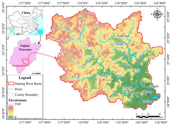
Figure 1.
Location map of the study area.
The basin’s climate is classified as subtropical humid monsoon, which means that it has substantial monsoon features, an abundance of light and heat, and abundant precipitation, but with uneven seasonal and regional distribution. The majority of the landscape is mountainous and hilly, with steep slopes.
The vegetation in the Jinjiang watershed primarily consists of man-made and natural forests, including Masson pine (Pinus massoniana), bamboo, and various subtropical broad-leaved species. The region also features large tea plantations, particularly in the hilly areas of Anxi County. Despite significant human influence, forested areas remain crucial for the region’s ecological health, providing essential services such as water conservation, soil retention, climate regulation, and biodiversity protection. According to the 2015 National Ecological Function Zoning, this region is designated as a key area for water conservation and biodiversity protection.
Notably, the region is home to endangered species such as the Chinese crested tern (Thalasseus bernsteini) and the spoon-billed sandpiper (Calidris pygmaea), both of which are critically endangered and nationally protected.
The ecosystem types in the Jinjiang watershed cover urban ecosystems, forest ecosystems, and agricultural ecosystems, making it an ideal area for this study. The principal crops include rice, sweet potatoes, peanuts, sugarcane, and soybeans. Jinjiang is also the largest carrot-growing base in Fujian Province, with its unique climate and soil characteristics enabling off-season cultivation, making it a key area for winter and spring carrot production and export.
The selection of the Jinjiang watershed as the study area is due to its representative nature of the ecological challenges faced by developed coastal regions globally. The area is experiencing rapid urbanization, which intensifies the conflict between urban development and ecological preservation. Additionally, the watershed’s significant role in providing various ecosystem services makes it an ideal case study for developing and testing comprehensive ecological security patterns. This region’s characteristics—combining high population density, economic development, and ecological significance—mirror the challenges faced by many other coastal regions worldwide. Therefore, insights gained from this study can be broadly applicable, providing valuable guidance for similar regions globally striving to balance urbanization with ecological sustainability.
2.2. Data Collection
The data used in this study were collected from multiple sources to ensure comprehensive coverage of the Jinjiang watershed. The primary data sources and their characteristics are as follows:
(1) Satellite Imagery: Landsat TM images were obtained from the United States Geological Survey (USGS) with a spatial resolution of 30 m. The images cover the period from January 2019 to December 2020, capturing different seasons to account for seasonal variations in vegetation and land use.
(2) Meteorological Data: Monthly precipitation and evapotranspiration data were retrieved from the National Meteorological Science Data Center (https://data.cma.cn/, accessed on 10 September 2020) with a spatial resolution of 1 km. These data cover the same period as the satellite imagery, ensuring temporal consistency.
(3) Topographical Data: Digital elevation model (DEM) data from the Shuttle Radar Topography Mission (SRTM) with a resolution of 30 m. These data were used to generate topographic features such as slope and aspect.
(4) Land Use and Land Cover Data: These data were derived from Landsat TM imagery through supervised classification and field verification, focusing on identifying tea gardens, farmlands, and residential areas.
(5) Soil Data: Soil attributes data were sourced from the Soil Science Database (http://vdb3.soil.csdb.cn/, accessed on 23 September 2020). This includes soil types, texture, and other relevant characteristics.
All data were subjected to preprocessing steps, including geometric correction, atmospheric correction, and resampling, to ensure spatial and temporal consistency. The data were then integrated into a unified spatial reference system using ArcGIS software 10.8 for further analysis.
2.3. Methods
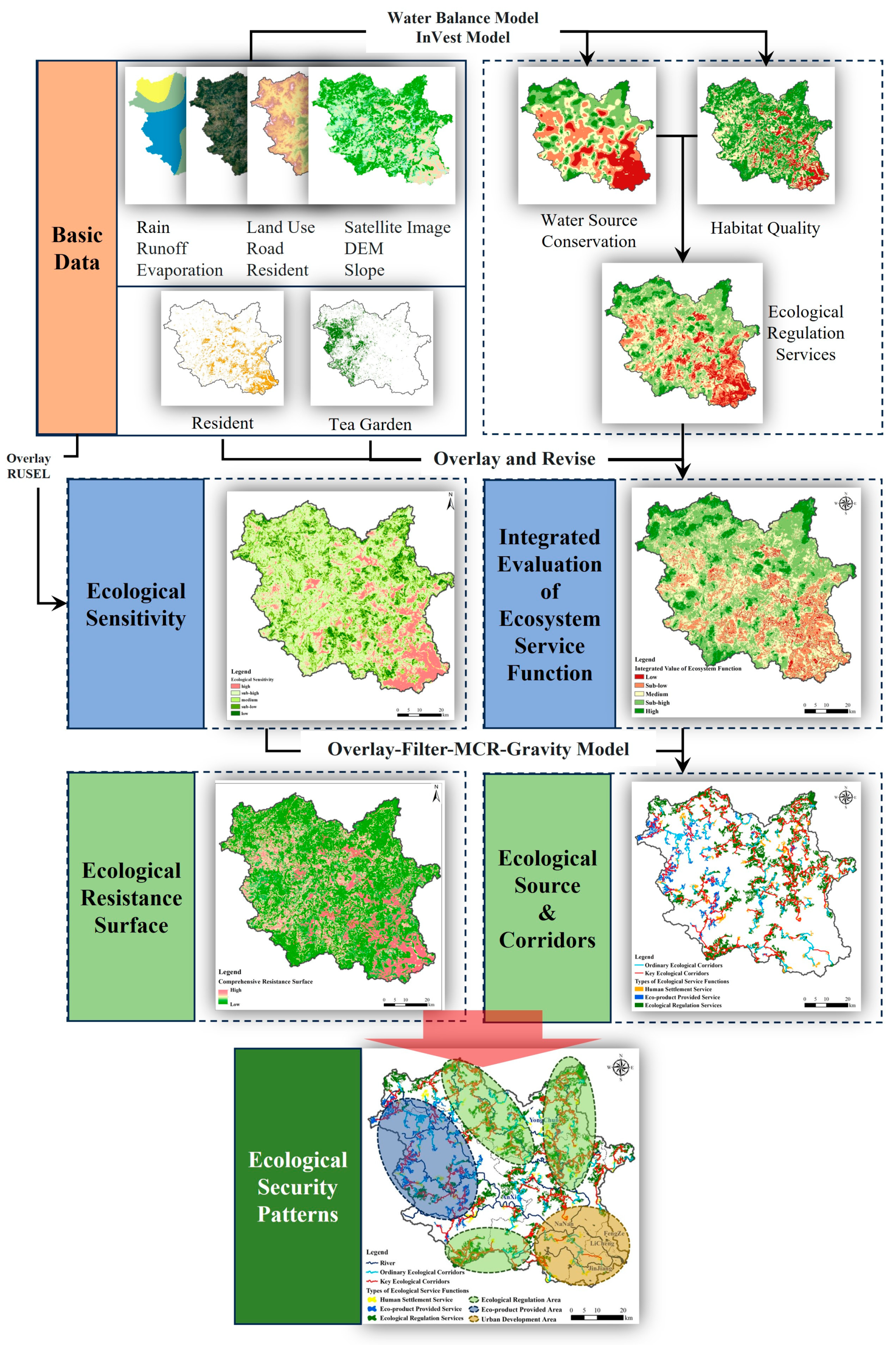
The methodology employed in this study to develop a comprehensive ecological security pattern for the Jinjiang watershed is shown in Figure 2. The approach integrates multiple ecosystem service functions—ecological regulation, eco-product provisions, and human settlement services—with ecological sensitivity assessment. This integrated approach addresses the conflict between urban development and ecological preservation in developed coastal cities. The key steps involve: (1) Integrated evaluation of ecosystem service functions and ecological sensitivity to identify source areas for ecological regulation, eco-product provisions, and human settlement; (2) Construction of a resistance surface to model ecological connectivity, incorporating land cover, slope, and human disturbances; (3) Extraction of ecological corridors using the minimum cumulative resistance (MCR) model to ensure landscape connectivity; (4) Development of the final ecological security pattern by integrating identified ecological sources, resistance surfaces, and ecological corridors.

Figure 2.
Workflow of construction of the ESP.
2.3.1. Integrated Evaluation of Ecosystem Service Function
The integrated evaluation of ecosystem service functions is a key innovation of this study, addressing the complex interactions and conflicts between urban development and ecological preservation in developed coastal cities. The purpose of integrating multiple ecosystem service functions—ecological regulation, eco-product provisions, and human settlement services—is to develop a comprehensive understanding of how these services interact and impact the overall ecological security of the Jinjiang watershed.
By combining these services with ecological sensitivity assessment, this study aims to identify areas that are critical for maintaining ecological balance while supporting urban growth and agricultural productivity. This integrated approach ensures that the ecological security pattern is robust, sustainable, and reflective of the diverse needs of densely populated coastal regions. The identification of three types of ecological sources based on this integration is a novel contribution, providing a holistic framework that has not been previously applied in similar contexts.
Selecting indicators for each ecosystem service function is crucial for accurately capturing the respective contributions to ecological regulation, eco-product provisions, and human settlement services. The indicators were chosen based on their relevance to the specific environmental, economic, and social characteristics of the Jinjiang watershed, as well as their ability to provide measurable and meaningful data for the integrated evaluation (Table 1).

Table 1.
Ecosystem service functions evaluated in the study.
- (1)
- Ecological Regulation Services
The abundant water resources and over 60% forest coverage in the Jinjiang watershed provide a natural advantage for ecological regulation in the region. Habitat quality refers to the suitability of habitats within a given region for the distribution of organisms, the preservation of biodiversity, and the support of ecologically suitable areas for the sustainable development and existence of individuals and populations [40]. In view of this, this study employs water conservation and habitat quality as evaluation indicators to gauge the significance of ecological regulation.
This study employs the water balance equation to quantify the water conservation capacity of the study area [41]. The InVEST (Integrate Valuation of Ecosystem Service and Tradeoffs Tool) model’s habitat quality module is one of the most commonly used methods for evaluating habitat quality [42]. Considering the natural resources and population distribution patterns of the Jinjiang watershed, habitats in this study are defined as bare land, water bodies, forest land, grassland, and cultivated land. Conversely, other land uses are categorized as non-habitat. The identified sources of threats to habitats include built-up areas, railways, and highways.
- (2)
- Eco-product Provision Services
Tea is the most important agricultural product in the Jinjiang watershed [43], and together with farmland, they are the core indicators that reflect the function of providing ecological products in the region. In this study, high-resolution satellite imagery and field surveys were used to identify areas dedicated to agricultural production. The indicators captures the economic value and ecological contributions of agricultural lands, highlighting their role in providing eco-products.
- (3)
- Human Settlement Services
Residential areas were mapped using high-resolution satellite imagery, and a 15 min accessibility buffer was created around these areas to delineate zones of human settlement services. This indicator ensures that the spatial extent of residents’ recreational and ecological needs is considered in the ecological security pattern.
2.3.2. Ecological Sensitivity Assessment
The term ecological sensitivity describes how the ecosystem environment reacts to disruptions in natural and human activities within the region, indicating the intensity and likelihood of causing ecological environmental issues [44]. Through ecological sensitivity assessment, it is possible to screen out areas that are highly sensitive and not easily restored after a disturbance. Due to the complex terrain and uneven seasonal and regional distribution of precipitation in the Jinjiang watershed, geological disasters and soil erosion have caused serious social, economic, and ecological damage. In order to assess the ecological sensitivity in the basin, this study has chosen soil erosion and geological disaster susceptibility as its primary ecological environmental concerns.
The sensitivity of soil erosion is evaluated using the Revised Universal Soil Loss Equation (RUSLE). Due to the close relationship between geological disasters and landforms in the Jinjiang watershed, and their susceptibility to human-induced activities, elevation, slope, terrain undulation, and human activity intensity are selected as evaluation factors. The intensity of human activities can be partially characterized by the types of land cover. In this study, a grading system is employed to assign values to different land use types for assessment, as depicted in Table 2. The sensitivity of soil erosion and geological hazards are weighted and overlapped to derive the evaluation outcomes of ecological sensitivity. The regions are then classified into five levels: highly sensitive, sensitive, relatively sensitive, moderately sensitive, and not sensitive.
Table 2.
Division criteria of influencing factors and sensitivity of geological hazards.
By integrating these indicators above all, the study provides a comprehensive and multi-dimensional evaluation of the Jinjiang watershed, ensuring that the resulting ecological security pattern effectively balances ecological regulation, eco-product provisions, and human settlement services.
2.3.3. Construction of Ecological Security Pattern
This study adopts the well-established standard paradigm for constructing ecological security patterns. The construction of the ecological security pattern for the Jinjiang watershed involves several key steps, with a particular focus on the innovative extraction of ecological sources. This process integrates multiple ecosystem service functions and ecological sensitivity to address the complex interactions between urban development and ecological preservation.
- (1)
- Identification of an ecological source area
An ecological source area denotes a land use system characterized by a high ecological system service value and the capacity to consistently yield valuable ecological outputs in a sustainable manner [45]. It serves as a vital component in upholding the stability of the ecosystem. In addition, ecological source areas are habitats for indigenous species, exhibiting internal homogeneity and the capability to expand or attract outwardly, characterized by a high-quality ecological environment [46]. They primarily contribute to the supply of essential ecosystem services, the preservation of ecosystem stability, and the avoidance of ecosystem degradation, all of which are important characteristics for constructing the foundation of an ecological security pattern.
This study combines the importance of ecosystem service functions and ecological sensitivity with weights of 0.6 and 0.4, respectively, and uses the reclassification function of ArcGIS to classify the regions according to the natural break method and extract the top two levels of regions as alternative source areas. Some studies have shown that small and discontinuous ecological source patches may offer restricted ecosystem service functions [47]. Therefore, considering the different classifications of ecosystem service functions in the study region, ecological protection areas with patch areas larger than 1 km2 are selected from the alternative source areas as ecological source areas.
The ecological source area derived from modified tea gardens and farmland indicates the product supply function, while the source area obtained through the modification of residential and buffer areas serves as an ecological source area for human habitation protection.
- (2)
- Construction of ecological resistance surface
Ecological resistance is the hindrance that species and ecological functions encounter during the processes of spatial control and dispersion [48]. Land use and slope are the two major factors selected for the construction of resistance surfaces (Table 3). The primary resistance surface is obtained through weighted overlay. As urbanization progresses and economic and social activities intensify, human activities further enhance the degree of interference with ecological conditions. Under the same land cover type, there are differences in human interference. To further delineate the range of human activity impacts, night light data are employed to adjust the resistance surface. The calculation formula is as follows:
Table 3.
Factors of ecological resistance surface.
Here, is the modified resistance value of the grid; is the nightlight index of the grid; represents the average nightlight index of land cover type a corresponding to the grid; and is the primary resistance coefficient of the grid.
- (3)
- Extraction of ecological corridors
Ecological corridors are crucial paths for matter exchange and energy flow within an ecosystem, with excellent material energy flow performance [49]. They can connect different areas to form an ecological network, maintaining ecosystem stability. They serve as vital mechanisms for upholding ecological functional services, ensuring effective circulation of ecological factors between source areas, and maintaining the stability of ecological processes.
To extract ecological corridors, we apply the minimum cumulative resistance (MCR) model. The model quantifies the cumulative resistance encountered from the ecological “source point” to the target landscape unit, reflecting species movement trends and the potential utilization of the ecological environment. It can better calculate the minimum cost route consumed between ecological source points, accurately reflecting the possibility and direction of energy flow and transfer within the ecosystem [50]. The formula is noted as follows:
is the cumulative resistance value to reach a certain point in space, reflects the positive correlation between cumulative resistance value and landscape ecological processes, indicates the minimum cumulative resistance value, represents the spatial distance from spatial landscape to spatial landscape , and represents the resistance coefficient of landscape to a certain target ecological vitality.
To delve further into the important ecological corridors and enhance the ecological security pattern, ecological corridors with key connections and influences between spatial landscapes are defined as key corridors. These corridors connect landscapes at a local level are defined as potential corridors. The ecological systems connected by key corridors have relatively high landscape consistency, which is conducive to the material and information exchange. The intersections of potential corridors play a role in communicating and exchanging various ecological source points within the ecological structure, while also providing a resting function for biological migration.
The gravity model can construct interaction matrices among ecological source areas, identify key corridors and ordinary corridors, and build hierarchical ecological corridor networks.
represents the interacting force between source site a and source site b, and are the weight of two ecological source areas, is the standardized potential corridor resistance between patches and is the resistance value of the patch, is the area of the patch, is the accumulated resistance value of the corridor between patches, and is the maximum accumulated resistance value of all corridors in the study region.
3. Results
3.1. Ecological Source Area in Jinjiang Watershed
In line with the study’s objective to construct a comprehensive ecological security pattern, we first identified the ecological source areas within the Jinjiang watershed. This integration of multiple ecological service functions is a novel approach aimed at enhancing regional ecological sustainability.
3.1.1. Integrated Ecological Service Evaluation Results
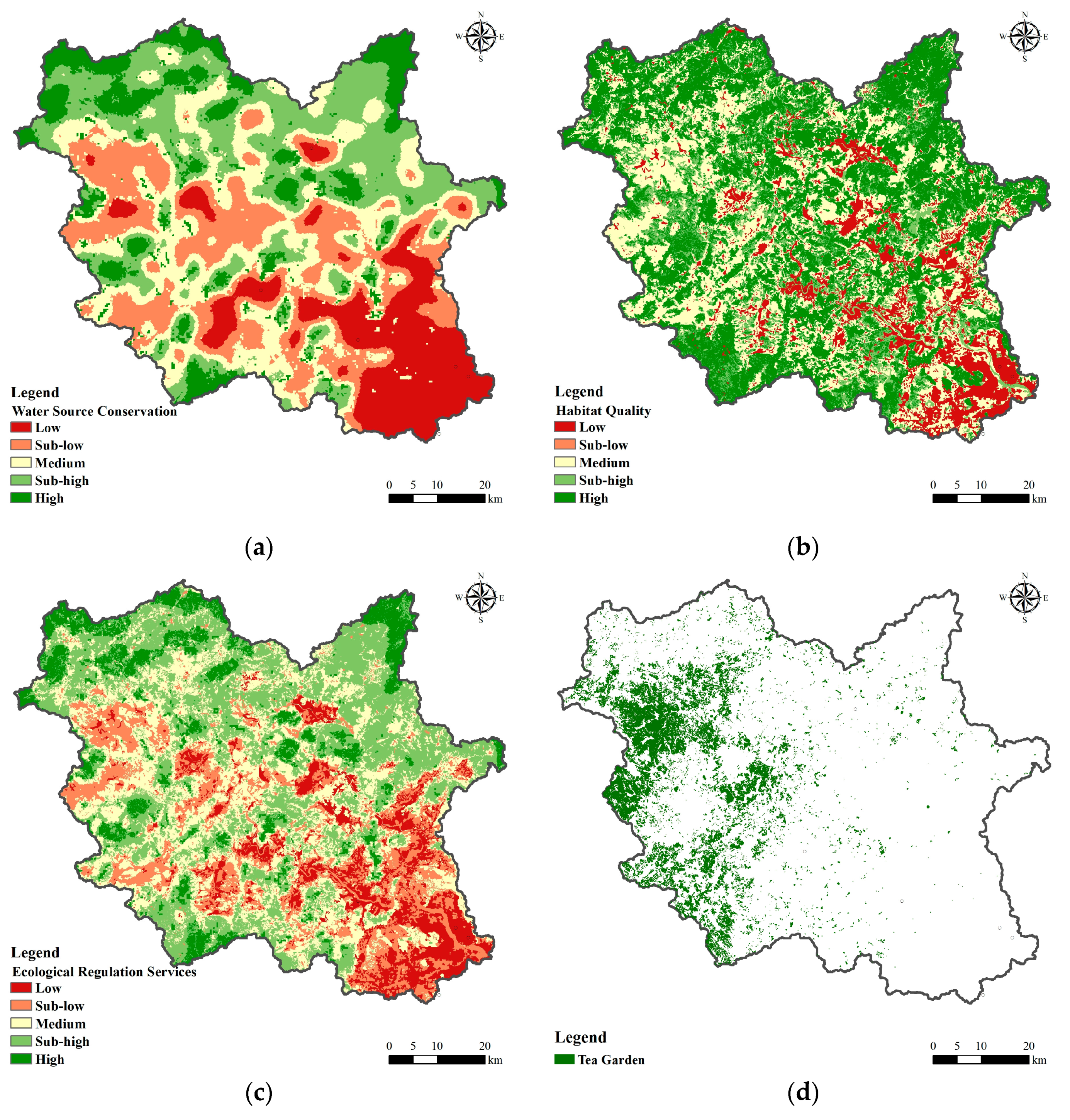
Based on the evaluation of individual factors contributing to the ecological regulation service, areas with high-value water conservation function are predominantly situated in the hilly and mountainous regions characterized by high annual precipitation and dense vegetation coverage within the study area. This area also has high ecological regulation service characteristics, including the northwest and northeast parts of Yongchun County, and the western hilly areas of Anxi County (Figure 3a). High-value areas of habitat quality are widespread in forested mountainous regions less affected by human activities (Figure 3b), while low-value areas are primarily found in developed areas such as valleys and coastal plains (Figure 3c). Under the combined action of these two factors, regions characterized by minimal human impact and dense vegetation coverage in the study area exhibit robust ecological regulation functions (Figure 3d,e).
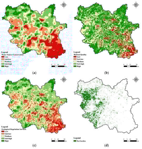
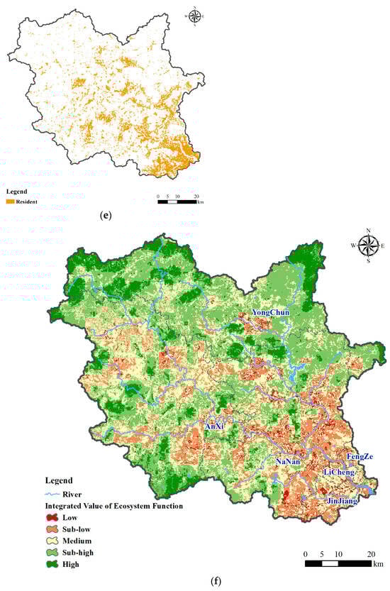
Figure 3.
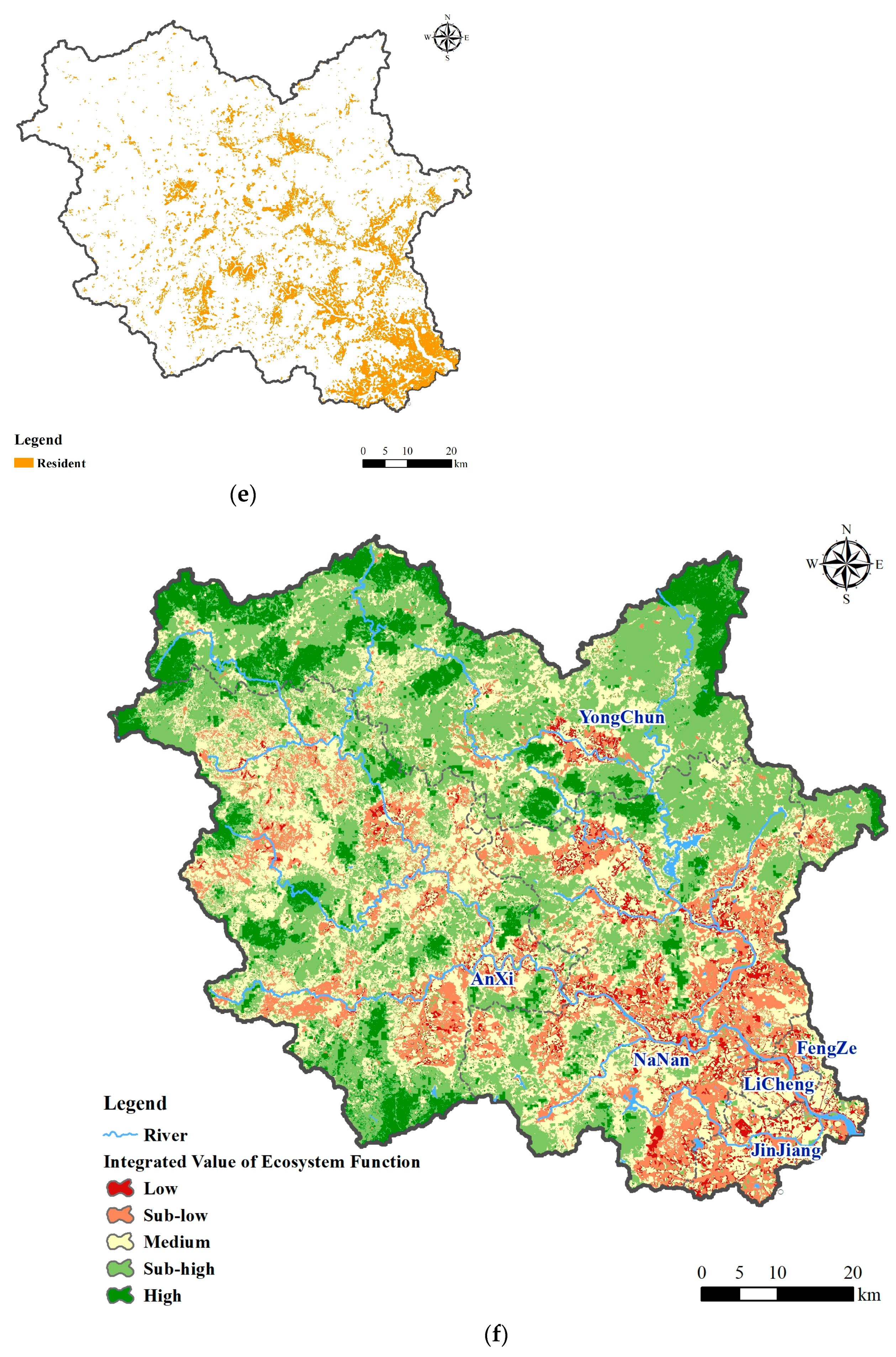
Assessment of the integrated value of ecosystem service function: (a) water source conservation; (b) habitat quality; (c) ecological regulation services; (d) distribution of tea gardens and crops; (e) distribution of residents; (f) integrated value of ecosystem service function.
The comprehensive ecosystem service functions corrected by the range of residential areas, tea gardens, and farmland obtained through interpretation show the following: (a) The influencing factors of the high-value comprehensive ecosystem areas are still mainly ecological regulation, similar to the evaluation outcomes of ecological regulation services, distributed in forested hilly areas with high vegetation coverage. (b) Tea-covered areas have higher service value due to their product supply function. (c) Small parks and green spaces within the built-up areas of valleys and plains present as small high-value ecological service areas due to their service in providing human settlement services.
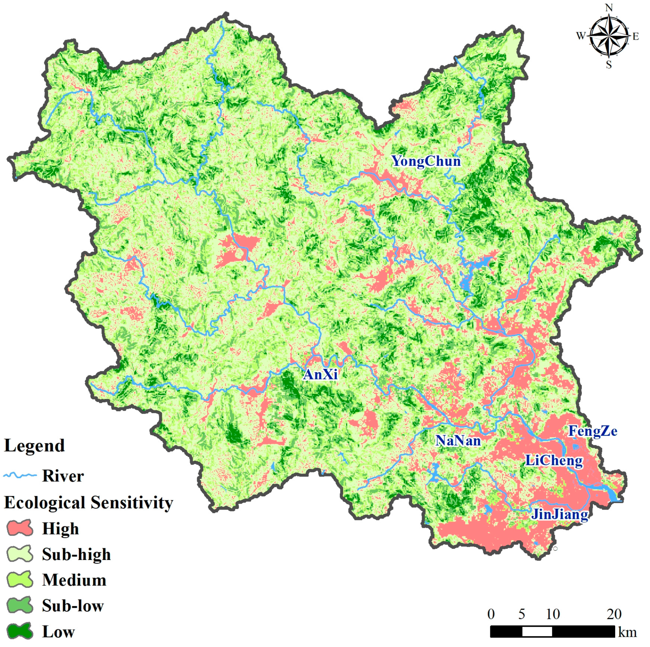
3.1.2. Results of Ecological Sensitivity Assessment
Ecological sensitivity, as depicted in Figure 4, is primarily distributed in the hilly tea garden regions in the eastern part of Anxi County, the concentrated residential areas in Yongchun County towns, and areas such as Licheng District. These areas are heavily influenced by human activities, have less vegetation, and are prone to soil erosion. It is worth mentioning that the excessive development of hilly areas due to the extensive cultivation of rock tea in Anxi County has exacerbated soil erosion [51].
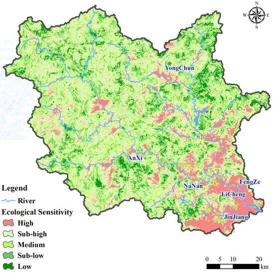
Figure 4.
Assessment of ecological sensitivity.
The medium-value areas are dispersed geographically, primarily in areas such as Licheng District, the northern residential areas of the city, and the southern plains of Nan’an County. These areas have flat terrain and a lack of forest and grass cover, which exacerbates ecological sensitivity due to soil erosion. Dehua County in the southeast mountainous area, the hilly plateau in the north of Nan’an County, and Guanqiao Town in Anxi County exhibit relatively low ecological sensitivity. These areas feature intricate terrain and are subject to minimal human influence.
The combined area of highly sensitive and sensitive ecological zones in the Jinjiang River Basin covers 3091.77 km2, representing 55.21% of the total study area. These zones are predominantly located in the eastern part of Anxi County and the residential areas of Yongchun County towns. The southern plain region, characterized by high ecological sensitivity, is particularly vulnerable to environmental damage due to economic development. Effective strategies to mitigate ecological sensitivity issues should be prioritized, focusing on balancing economic growth with ecological conservation.
3.1.3. Results of Ecological Source Area Identification
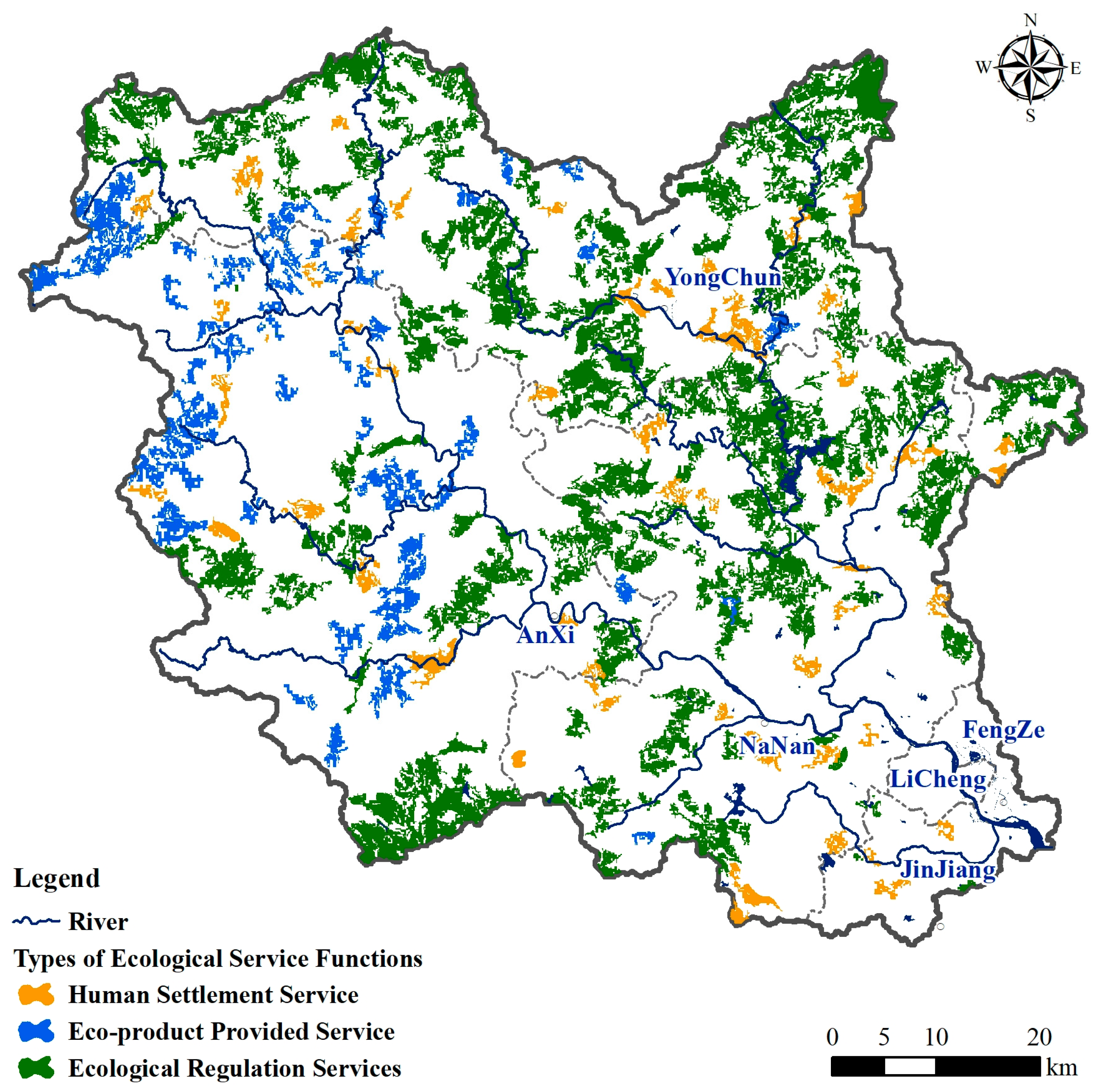
Through a thorough assessment of ecological service functions and sensitivity, utilizing weighted superimposition and screening methods, 322 ecological source areas are identified. After excluding scattered and fragmented patches, these areas cover a total area of 1287.18 km2, representing 22.96% of the total study area. Among them, the ecological regulation service source areas with high habitat quality are mostly forests, primarily distributed in the hilly and mountainous regions in the north of Nan’an City, the forested area of Yongchuan County, and the hilly and mountainous areas in the south of Anxi County. The main source areas of eco-product providing services such as tea gardens are mainly distributed in Anxi County. These are the regions where economic development and environmental ecology are most closely correlated. The distribution of source areas for human settlement services is relatively dispersed. They are mainly located in the plain areas characterized by intensive human activities. Urban areas are situated in mountainous valleys, including urban green spaces in Quanzhou, Jinjiang city, and the county town of Yongchun. The distribution reflects a balance between ecological protection and the well-being needs of urban residents.
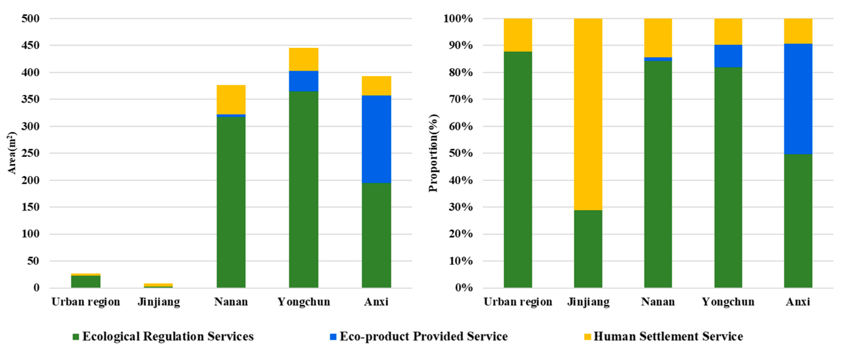
Considering the characteristics of the source areas, it can be seen from the area map of each county (Figure 5) that Yongchun County has the largest source area, followed by Anxi County, both of which are mainly ecological regulation service source areas. Among them, the area providing eco-products and services in Anxi County constitutes 40% of the total source area, the highest proportion among the five zones, and serves as the primary region for tea production. The ecological source areas for human settlement service are distributed in all five zones, with Jinjiang City having the largest distribution. On the other hand, the Quanzhou urban area allocates a relatively low proportion of its area for human settlement services. This indicates a scarcity of green space to meet the ecological requirements of urban residents during the process of urban development in the central urban area. With the exception of Jinjiang City, ecological regulation predominates in all other districts and counties, comprising the largest proportion of the source area, and making the highest contribution to it.
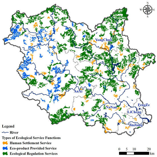
Figure 5.
Classification and distribution of ecological source areas.
From the perspective of landscape distribution, forests emerge as the most crucial land cover type in ecological source areas, serving as the primary source areas for ecological regulation services, encompassing 76.36% of the ecological source area (Figure 6). This is followed by tea gardens and farmland, which serve as the main types of eco-product and service source areas, comprising 16.83% of the ecological source area.
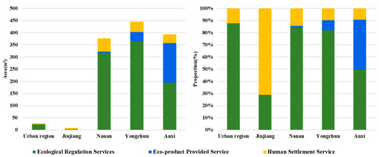
Figure 6.
Classification statistics of ecological source areas.
3.2. Ecological Resistance Surface in Jinjiang Watershed
The construction of ecological resistance surfaces is crucial for modeling ecological connectivity and barriers, supporting our hypothesis that this integration will promote sustainable development.
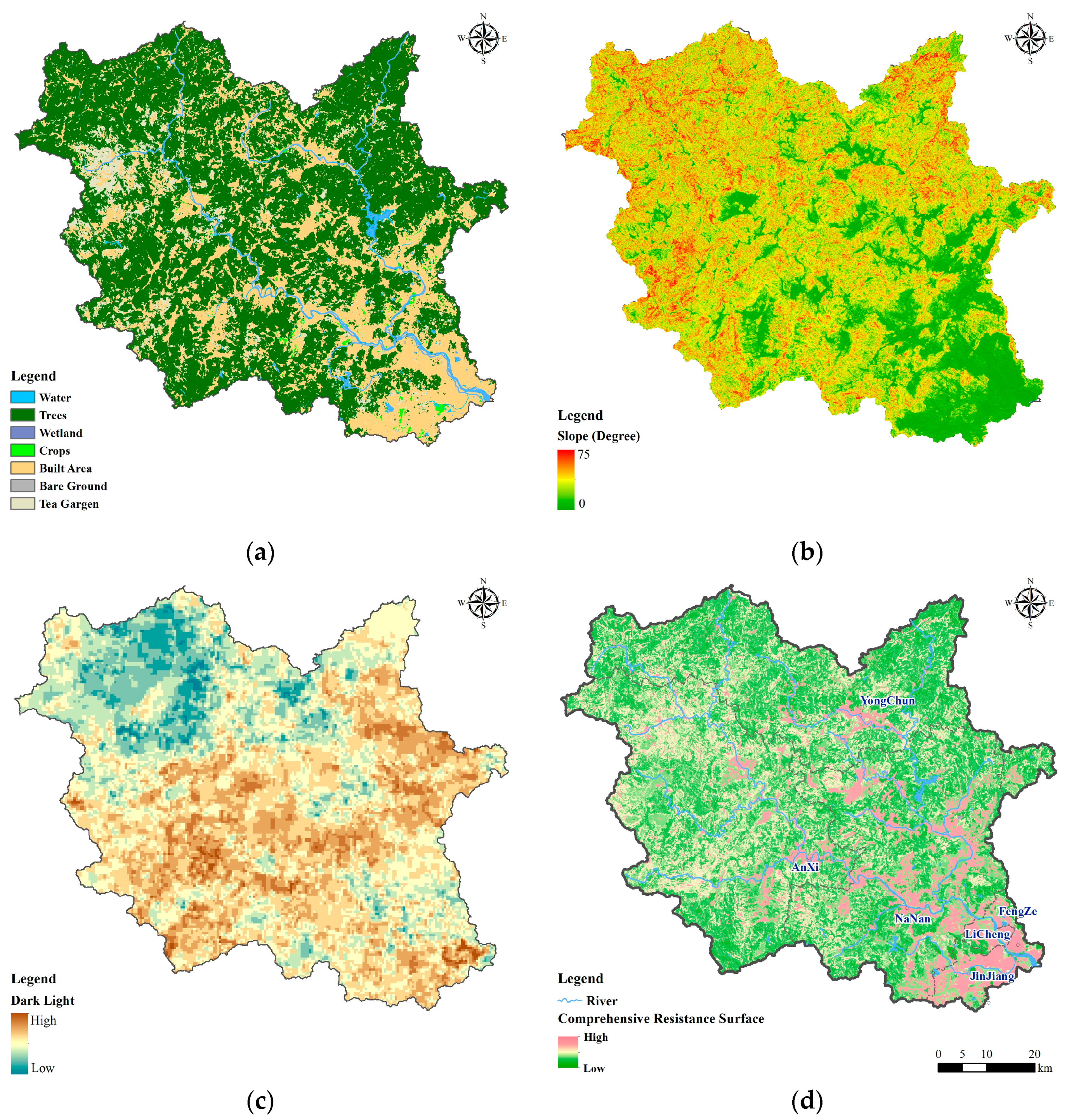
According to the distribution of resistance surfaces adjusted for dark light data (Figure 7a–c), the resistance values are higher on both sides of the river valley in the mountainous areas and in the plain area to the southeast, presenting an overall pattern of zonal distribution in the mountainous areas and a concentrated distribution pattern in the plain areas (Figure 7d).

Figure 7.
Construction of the comprehensive resistance surface: (a) land cover; (b) slope; (c) dark light; (d) comprehensive resistance surface.
Areas with higher resistance values are primarily located in urban regions such as Quanzhou city, Yongchun County, and Anxi County, characterized by high human activity frequency and predominant land use as built-up areas. In these areas, ecological flow is significantly restricted, exerting a resistance effect on species migration and material information diffusion in the surrounding regions. Surrounding the high-value area is the resistance median area, which is mainly affected by human activities, which negatively impact the transmission and exchange of ecological material information in this region. Areas with lower ecological resistance values are located in the mountainous and hilly regions in the northwest, mainly covered by forests and grasslands. This area has large undulating terrain, a good ecological environment with minimal impact from human activities, rich biological species, and a good ecological environment, which can produce a positive driving effect on the migration and diffusion of surrounding species.
The methodology for constructing resistance surfaces can be adapted to other developed coastal regions, providing a valuable framework for addressing similar ecological and urban challenges globally.
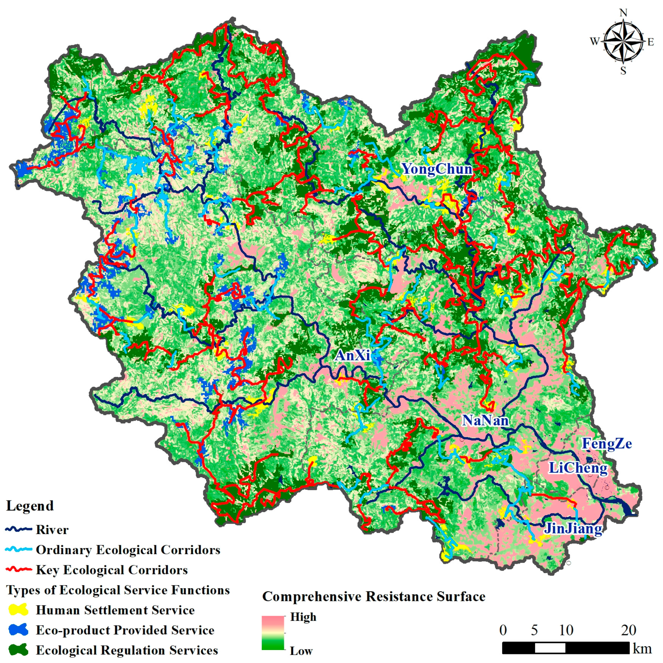
3.3. Ecological Corridors in Jinjiang Watershed
Following our objective to enhance regional ecological sustainability through the integration of multiple ecological service functions, we have identified and delineated ecological corridors that are crucial for maintaining ecological connectivity. This aligns with our hypothesis that such integration would support sustainable development.
According to the principle of minimum cost, 321 ecological corridors were identified, with a total length of 2420.98 km (Figure 8). Among them, 114 key corridors extend over a total length of 1941.67 km, primarily distributed in the Dongxi watershed, specifically in areas such as Yongchun County and the northern part of Nan’an City. These key corridors exhibit continuity and density, primarily serving to connect the source areas of ecological regulation functions. This type of corridor has high ecological type consistency and facilitates the communication of material energy within the region, making them more conducive to species migration.
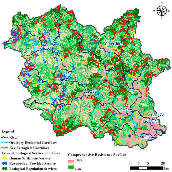
Figure 8.
Distribution of ecological corridors.
There are 207 ordinary corridors, totaling 479.31 km in length. These corridors are primarily distributed in the Xixi watershed and the plain region, close to areas affected by human activities. They tend to be relatively shorter in length and more intermittent in nature, mainly serving to connect ecological source areas with product supply value and human living guarantee value, ensuring the connectivity of ecological source areas in small areas.
Ecological source areas that characterize the ecological regulation service function in the Jinjiang River Basin are primarily concentrated near the mainstream of Dongxi and Huyangxi (one of tributaries of Dongxi) and the upper reaches of Lanxi. Through important corridors connecting the source areas, the ecological source areas along the above-mentioned lines are interconnected, ensuring the overall integrity and consistency of the pattern of ecological regulation service. The ecological source areas that provide eco-production services are distributed in the mountainous areas of Anxi County in the Xixi watershed, mainly concentrated in the YiDuXi-ShuangXi-LongTanXi-BlueXi basin range, connected in a circular pattern through corridors, reflecting to a certain extent the clustering characteristics of ecological product provision. The scattered distribution of source areas of residents’ ecological needs is primarily located in the county and urban areas, connected through potential corridors, and has relatively fragile ecological connectivity. The potential corridors are more for the purpose of ensuring the integrity and connectivity of the pattern. They are slightly more affected by resistance compared to the key corridors and are more threatened and influenced by human activities. To safeguard the overarching integrity and connectivity of the ecological security pattern in the Jinjiang watershed, more protection and restoration efforts are needed for potential corridors.
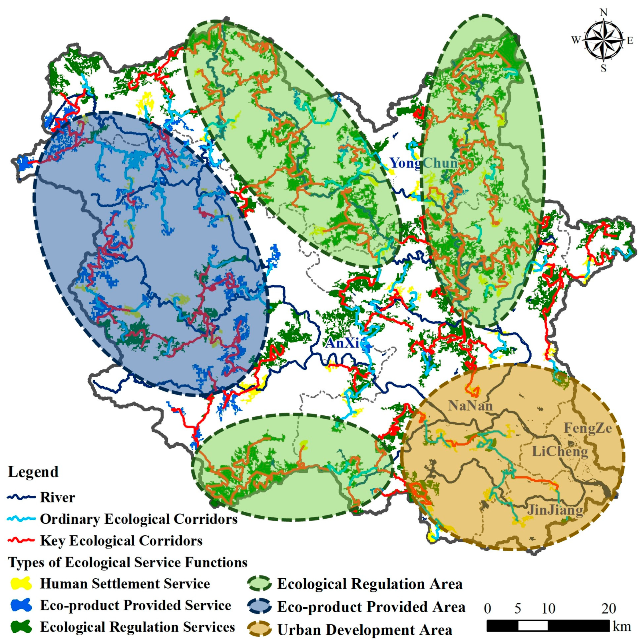
3.4. Ecological Security Pattern in Jinjiang Watershed
Drawing from the aforementioned research, a comprehensive ecological security pattern for the Jinjiang watershed was developed, incorporating three key service components (Figure 9). Based on the spatial distribution of ecological service functions, three types of ecological functional aggregation areas were delineated, comprising ecological regulation areas, eco-product provision areas, and urban development areas.
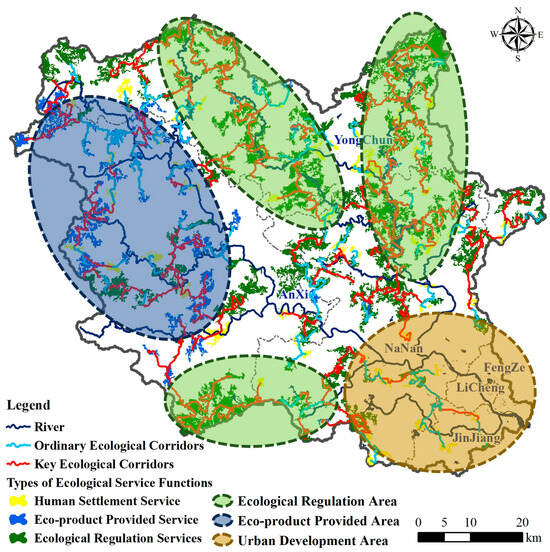
Figure 9.
Ecological security pattern in the Jinjiang watershed.
- (1)
- The ecological regulation area primarily encompasses regions where natural ecology maintenance and restoration efforts need to be intensified. It is predominantly situated in the upstream regions of the tributaries within the Jinjiang watershed, with low human impact and an overall good ecological environment and high forest coverage. The source water conservation area in the central and northern parts is mainly located within Yongchun County in the Shanmei Reservoir watershed. Yongchun County experiences a relatively high level of development. However, due to the Shanmei Reservoir’s task of supplying water to Kinmen, the overall ecological environment is good. The local area mainly focuses on ecological development for tourism and fruit orchards.
- (2)
- The eco-product provision area primarily serves the function of providing agricultural and forestry products and is mainly located within the Anxi County of the Xixi watershed. The local tea planting area is widely distributed, and there are many areas where forests have been converted into tea plantations, leading to serious soil erosion. Industrial and mining enterprises are clustered around Jiandou Town in Anxi County and significantly impact the water quality of rivers and groundwater in the region, making it the main source area of nitrogen and phosphorus pollutants in the Jinjiang watershed. To promote the harmonious and orderly co-development of production and ecology, it is imperative to enhance local environmental quality monitoring and regulate mining and mineral extraction enterprises.
- (3)
- The urban development area is situated at the lower reaches of the Jinjiang watershed and based on the results of surveys and surface water sampling analysis, it is also one of the main non-point source pollutants in the Jinjiang watershed. The Jinjiang river system is the main source of drinking water in Quanzhou and is a typical river-type drinking water source. To ensure the quality of the water at the intake, targeted measures for basin water environment zoning classification protection and management are needed.
The comprehensive ecological security pattern developed for the Jinjiang watershed aligns with our objective to integrate multiple ecological service functions, thereby enhancing regional sustainability. This pattern not only addresses the specific needs of the Jinjiang watershed but also serves as a model for other developed coastal regions globally. By incorporating ecological regulation, eco-product provisions, and human settlement services, we provide a holistic framework that promotes sustainable urban development and ecological conservation. Practical applications of this pattern include enhanced environmental monitoring, regulation of industrial activities, and targeted conservation measures to maintain ecological connectivity and sustainability.
4. Discussion
4.1. Advantages of Ecological Source Identification
The scientific identification of ecological source areas is a fundamental prerequisite for constructing an ecological security pattern. The Jinjiang watershed is an area that integrates highly developed coastal cities with areas of prominent natural ecological contradictions. This study identifies ecological source areas that meet the diverse needs of various ecosystem services from different service function perspectives and broadens the rationality of ecological source areas in such conflicting regions. The ultimate goal of ecosystem services is to ensure healthy and stable development at the regional level. Therefore, at the basin scale, it is crucial to focus on human needs, while taking into account the influence of cultural and recreational activities on the quality of urban residents’ lives, as well as the services of eco-product provided and microclimate regulation. These efforts not only ensure regional ecological security and uphold ecosystem stability but also fulfill the ecosystem service needs for enhancing the urban living environment, thereby greatly extending the framework of constructing an ecological security pattern.
The 14th Five-Year Plan emphasizes the robust growth of urban agglomerations, positioning them as the primary driving force behind the country’s new urbanization and key contributors to national prosperity. These urban agglomerations have the historical duty of shifting the global economy center. Consequently, the development of cities will lead to the widespread emergence of regions characterized by similar ecological contradictions. In these areas, ecological security issues will not only concern protecting natural ecology but also strive for balanced development between humans and nature while addressing human necessities.
Therefore, in our exploration, we examine the influence of different types of ecological source areas on the establishment of an ecological security pattern. Our findings indicate that the areas designated for ecological regulation services, which are characterized by their continuous distribution, occupy the largest area among the three types of source areas and play a crucial role in mitigating the environmental pressures associated with urbanization. The concentrated distribution of areas dedicated to providing ecological products not only boosts the agricultural output and income for local farmers but also creates employment opportunities and bolsters rural economy growth, thereby facilitating the urbanization process. The dispersed distribution of human settlement service source areas provides valuable recreational and leisure spaces for urban residents and those residing along river valleys, contributing to the quality of life and well-being of the citizens. Furthermore, these captivating natural landscapes and recreational spaces play a significant role in attracting tourists, thus promoting the growth of local tourism and associated service sectors. Therefore, the identification and preservation of ecological source areas tailored to different functions can effectively reconcile urban construction, agricultural development, and natural ecology, thereby providing a solution to the contradictions between urban construction and ecological preservation that often arise during the urbanization process.
4.2. Development Suggestions Based on the Ecological Security Pattern
By combining the landscape distribution features of Jinjiang watershed, the ecological security pattern is optimized, forming an ecological corridor with the mainstream of the Dongxi serving as the axis and the Yunding Mountain-Tianzhu Mountain serving as the ecological security barrier. It consists of four ecological security development proposal patterns: the northern ecological regulation zone, the central and southern ecological regulation zone, the region used for growing tea in the west and center, and the rapidly developing urban area at the mouth of the river in the south (Figure 10). Within the national ecological planning area, the Jinjiang watershed is part of the ecological water conservation area in western Fujian. The northern and central-southern ecological regulation zones, characterized by their high forest coverage, are considered natural and high-quality water conservation areas. Therefore, these zones require priority ecological protection, which can be achieved through the establishment of forest parks, nature reserves, and other relevant measures.
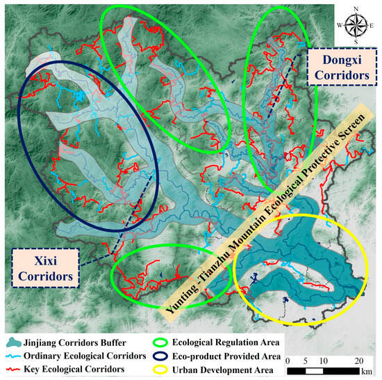
Figure 10.
Advice based on ecological security patterns in Jinjiang watershed.
The ecological security pattern reveals that core corridors primarily connect ecological regulation function source areas, offering a certain level of resilience compared to others and serving as the main conduit for ecological security in the Jinjiang watershed. Ordinary corridors, however, are positioned amidst minor watersheds of the Jinjiang River or spanning across various land cover types, making them more susceptible to disruptions arising from urban expansion. Therefore, ecological corridors should be designated as no-development zones, with coordinated planning at the provincial, municipal, and county levels, to ensure the connectivity of the corridor network. This entails advancing ecological construction projects like reclamation for afforestation and implementing forest closure programs, while establishing a comprehensive shelterbelt system integrating trees, shrubs, and grasslands into a multi-class, multi-layer natural protective layer.
Tea plantations are widely distributed in the central-western product provision areas, including regions where forests have been transformed into tea gardens. The presence of rich white quartz sand in the soil coupled with continuous weed removal throughout tea cultivation, results in the loss of fine soil through surface runoff following heavy rains. This process exposes the white sand and leading to a decline in soil quality. Moreover, the tea plants’ selective absorption of aluminum compounds from the laterite leads to rapid acidification of the surface soil in the tea gardens, further exacerbating the degradation of the soil’s surface fertility. Thus, while increasing the agricultural income of the region, the issue of soil erosion in hilly areas cannot be overlooked. It is essential to strike a balance between the economic benefits derived from agricultural products and the ecological restoration expenses incurred enhance soil erosion monitoring and foster the harmonious and orderly development of production ecology.
The southern urban development area, situated in the downstream plain area of the Jinjiang River basin, is the most densely populated area of Quanzhou City, with the highest demand for human settlement services. It is essential to protect existing ecological service green spaces while further constructing parks, green areas, and other public ecological service facilities to alleviate the ecological service demand pressure in the central urban development areas. Additionally, based on survey and surface water sampling analysis results, this area is also one of the main non-point sources of pollutants in the Jinjiang River basin. To prevent ecological degradation resulting from urbanization, targeted watershed water environment zoning protection and management are essential while ensuring the functionality of ecological services.
River ecological corridors are crucial components of the ecological security pattern, significantly impacting water conservation. Therefore, enhancing ecological protection of rivers and other water resources is particularly important. Specific plans should be adopted to further optimize water environment functional zoning, implement segmented river responsibility management, and strictly control industrial pollution to ensure water resource safety. Strengthening domestic sewage treatment, strictly regulating pollution from residential and industrial activities on water quality, and undertaking comprehensive restoration efforts for polluted rivers to rehabilitate ecologically damaged areas are examples of other recommendations.
4.3. Broader Implications and Practical Applications
The comprehensive ecological security pattern developed for the Jinjiang watershed aligns with our objective to integrate multiple ecological service functions, thereby enhancing regional sustainability. This pattern not only addresses the specific needs of the Jinjiang watershed but also serves as a model for other developed coastal regions globally. By incorporating ecological regulation, eco-product provisions, and human settlement services, we provide a holistic framework that promotes sustainable urban development and ecological conservation.
Practical applications of this pattern include enhanced environmental monitoring, regulation of industrial activities, and targeted conservation measures to maintain ecological connectivity and sustainability. For instance, local governments can use these findings to designate ecological corridors as no-development zones, ensuring the connectivity of the ecological network. This approach can also inform the planning and management of similar regions globally, contributing to the broader discourse on sustainable urban development and ecological preservation.
Moreover, the potential for scaling this methodology to other regions should be explored. Coastal regions worldwide face similar challenges of balancing urban development with ecological preservation. The approach used in this study can be adapted to different local contexts, providing valuable insights for global applications. Future research should focus on refining this model and testing its applicability in diverse environmental and socio-economic settings.
4.4. Critical Analysis of Results
While this study provides a robust framework for constructing ecological security patterns in developed coastal regions, there are some limitations and areas for improvement. The reliance on remote sensing data for land use classification introduces uncertainties due to the spatial and temporal resolution of the data. Incorporating ground truthing methods and higher resolution data can improve accuracy.
Additionally, the study’s focus on the Jinjiang watershed means that certain localized factors may not be applicable to other regions without adjustments. The weighting of ecological service functions, for example, could be adapted to better reflect the specific ecological, economic, and social conditions of different regions.
Furthermore, the impact of climate change on ecological security patterns was not extensively addressed in this study. Future research should consider how changing climate conditions might affect ecological regulation, eco-product provisions, and human settlement services and how adaptive measures can be integrated into the ecological security patterns.
By addressing these limitations and refining the methodology, the ecological security pattern framework can be made more robust and widely applicable, offering a valuable tool for sustainable urban and regional planning.
5. Conclusions
This study addresses the critical intersections of ecology, production, and living spaces in rapidly developing coastal cities in China. Using the Jinjiang watershed as a case study, we applied the “source identification—resistance surface construction—corridor extraction” methodology to develop an ecological security pattern that integrates ecological regulation, eco-product provisions, and human settlement services.
The results identified 322 ecological source areas covering 1287.18 km2 and 2420.98 km of ecological corridors. Ecological regulation areas are primarily in northern mountainous regions, eco-product provision areas are concentrated in Anxi County, and human settlement services are dispersed in densely populated plains and river valleys.
While the methodology provides a robust framework, limitations include potential inaccuracies from satellite imagery and the need for ground truthing. The weighting of ecological service functions should be tailored to local conditions.
This ecological security pattern offers a replicable model for other coastal regions globally. Practical applications include enhanced environmental monitoring, stricter regulation of industrial activities, and targeted conservation efforts. The following key recommendations are highlighted: (1) Enhanced Protection: Designate key corridors as no-development zones to preserve ecological integrity. (2) Soil Erosion and Acidification Mitigation: Optimize tea garden layouts and restore affected areas. (3) Urban Green Space Development: Construct green parks to meet ecological needs and boost tourism. (4) Comprehensive Monitoring: Implement continuous environmental monitoring to assess the effectiveness of the ecological security pattern and adapt policies as necessary.
The ecological security pattern developed for the Jinjiang watershed demonstrates the feasibility of integrating multiple ecological service functions to support sustainable urban development. These findings offer a replicable model for other coastal regions globally, promoting a balance between urban growth and ecological conservation. Practical applications include enhanced environmental monitoring, regulation of industrial activities, and targeted conservation measures. Future research should refine these methods and explore their applicability in diverse contexts.
Author Contributions
Conceptualization, Y.Z. and Y.X.; methodology, Y.Z.; software, J.L. (Jiahuan Liu); validation, Y.L. (Yaci Liu); formal analysis, Y.Z.; investigation, Y.Z. and J.L. (Jianfeng Li); resources, Y.Z.; data curation, Y.X.; writing—original draft preparation, Y.Z.; writing—review and editing, Y.X., Y.L. (Yasong Li), and Z.Z.; visualization, C.L.; supervision, Q.H. and C.L.; project administration, Y.L. (Yasong Li); funding acquisition, Y.X. and Y.L. (Yasong Li). All authors have read and agreed to the published version of the manuscript.
Funding
This research was supported by the Fujian Provincial Key Laboratory of Water Cycling and Eco-Geological Processes (SK202305KF01), the China Geological Survey (DD20190303 and DD20230459), the National Natural Science Foundation of China (42007183, 41702282), the Natural Science Foundation of Sichuan Province (2022NSFSC1084), MOE Key Laboratory of Groundwater Circulation and Environmental Evolution, China University of Geosciences (Beijing) (2023-004), the Student Research Training Program of Southwest Jiaotong University (241925), Open Fund of Key Laboratory (No.WSRCR-2023-01).
Data Availability Statement
The data that support the findings of this study are available upon reasonable request from the authors.
Conflicts of Interest
The authors declare no conflicts of interest. The funders had no role in the design of the study; in the collection, analyses, or interpretation of data; in the writing of the manuscript; or in the decision to publish the results.
References
- Li, Q.; Zhou, Y.; Yi, S. An integrated approach to constructing ecological security patterns and identifying ecological restoration and protection areas: A case study of Jingmen, China. Ecol. Indic. 2022, 137, 108723. [Google Scholar] [CrossRef]
- Liu, J.; Cheng, Y.; Zhang, F.; Wen, X.; Yang, L. Research hotspots and trends of groundwater and ecology studies: Based on a bibliometric approach. J. Groundw. Sci. Eng. 2023, 11, 20–36. [Google Scholar] [CrossRef]
- Hu, J.; Huang, Y.; Du, J. The impact of urban development intensity on ecological carrying capacity: A case study of ecologically fragile areas. Int. J. Environ. Res. Public Health 2021, 18, 7094. [Google Scholar] [CrossRef] [PubMed]
- Fang, Z.; Ding, T.; Chen, J.; Xue, S.; Zhou, Q.; Wang, Y.; Wang, Y.; Huang, Z.; Yang, S. Impacts of land use/land cover changes on ecosystem services in ecologically fragile regions. Sci. Total Environ. 2022, 831, 154967. [Google Scholar] [CrossRef] [PubMed]
- Tong, S.; Beggs, P.J.; Davies, J.M.; Jiang, F.; Kinney, P.L.; Liu, S.; Yin, Y.; Ebi, K.L. Compound impacts of climate change, urbanization and biodiversity loss on allergic disease. Int. J. Epidemiol. 2023, 52, 655–663. [Google Scholar] [CrossRef] [PubMed]
- Eswaran, H.; Lal, R.; Reich, P. Land degradation: An overview. In Response to Land Degradation; CRC Press: Boca Raton, FL, USA, 2019; pp. 20–35. [Google Scholar]
- Lin, G.; Jiang, D.; Fu, J.; Zhao, Y. A review on the overall optimization of production–living–ecological space: Theoretical basis and conceptual framework. Land 2022, 11, 345. [Google Scholar] [CrossRef]
- Shah, M.I.; Abbas, S.; Olohunlana, A.O.; Sinha, A. The impacts of land use change on biodiversity and ecosystem services: An empirical investigation from highly fragile countries. Sustain. Dev. 2023, 31, 1384–1400. [Google Scholar] [CrossRef]
- Jiang, B.; Chen, W.; Dai, X.; Xu, M.; Liu, L.; Sakai, T.; Li, S. Change of the spatial and temporal pattern of ecological vulnerability: A case study on Cheng-Yu urban agglomeration, Southwest China. Ecol. Indic. 2023, 149, 110161. [Google Scholar] [CrossRef]
- Li, X.; Xiao, L.; Tian, C.; Zhu, B.; Chevallier, J. Impacts of the ecological footprint on sustainable development: Evidence from China. J. Clean. Prod. 2022, 352, 131472. [Google Scholar] [CrossRef]
- Kang, J.; Zhang, X.; Zhu, X.; Zhang, B. Ecological security pattern: A new idea for balancing regional development and ecological protection. A case study of the Jiaodong Peninsula, China. Glob. Ecol. Conserv. 2021, 26, e01472. [Google Scholar] [CrossRef]
- Liu, C.; Li, W.; Xu, J.; Zhou, H.; Li, C.; Wang, W. Global trends and characteristics of ecological security research in the early 21st century: A literature review and bibliometric analysis. Ecol. Indic. 2022, 137, 108734. [Google Scholar] [CrossRef]
- Zeng, P.; Wei, X.; Duan, Z. Coupling and coordination analysis in urban agglomerations of China: Urbanization and ecological security perspectives. J. Clean. Prod. 2022, 365, 132730. [Google Scholar] [CrossRef]
- Cui, X.; Deng, W.; Yang, J.; Huang, W.; de Vries, W.T. Construction and optimization of ecological security patterns based on social equity perspective: A case study in Wuhan, China. Ecol. Indic. 2022, 136, 108714. [Google Scholar] [CrossRef]
- Ye, H.; Song, Y.; Xue, D.; Xia, S.; Tang, Y.; Zhang, L. Construction of an ecological security pattern for the Guanzhong Plain urban agglomeration: Scale perspective and hierarchy demand. Front. Environ. Sci. 2023, 11, 1136630. [Google Scholar] [CrossRef]
- Zhang, X.; Liu, G.; Zheng, Z. Construction of an ecological security pattern based on functional wetland theory: A case study in a landscape city. Front. Environ. Sci. 2022, 10, 955230. [Google Scholar] [CrossRef]
- Rauch, H.; von der Thannen, M.; Raymond, P.; Mira, E.; Evette, A. Ecological challenges for the use of soil and water bioengineering techniques in river and coastal engineering projects. Ecol. Eng. 2022, 176, 106539. [Google Scholar] [CrossRef]
- De La Cruz, C.; Manuel, P. The knowledge status of coastal and marine ecosystem services-challenges, limitations and lessons learned from the application of the ecosystem services approach in management. Front. Mar. Sci. 2021, 8, 684770. [Google Scholar] [CrossRef]
- Hysa, A.; Löwe, R.; Geist, J. Ecosystem services potential is declining across European capital metropolitan areas. Sci. Rep. 2024, 14, 8903. [Google Scholar] [CrossRef] [PubMed]
- Yutian, S.; Jin, F.; Liyan, X. Review of Ecological Infrastructure Planning Practices Based on the Ecological Security Pattern Theory in China (1997~2019). Landsc. Archit. Front. 2021, 9, 28–48. [Google Scholar]
- Zhu, B.; Hashimoto, S.; Cushman, S.A. Navigating ecological security research over the last 30 years: A scoping review. Sustain. Sci. 2023, 18, 2485–2498. [Google Scholar] [CrossRef]
- Fu, Y.; Shi, X.; He, J.; Yuan, Y.; Qu, L. Identification and optimization strategy of county ecological security pattern: A case study in the Loess Plateau, China. Ecol. Indic. 2020, 112, 106030. [Google Scholar] [CrossRef]
- Ma, B.; Zhou, T.; Lei, S.; Wen, Y.; Htun, T.T. Effects of urban green spaces on residents’ well-being. Environ. Dev. Sustain. 2019, 21, 2793–2809. [Google Scholar] [CrossRef]
- Ke, Y.; Bai, Y.; Ali, M.; Ashraf, A.; Li, M.; Li, B. Exploring residents’ perceptions of ecosystem services in nature reserves to guide protection and management. Ecol. Indic. 2024, 158, 111535. [Google Scholar] [CrossRef]
- Yan, Y.; Ju, H.; Zhang, S.; Chen, G. The construction of ecological security patterns in coastal areas based on landscape ecological risk assessment—A case study of Jiaodong Peninsula, China. Int. J. Environ. Res. Public Health 2021, 18, 12249. [Google Scholar] [CrossRef] [PubMed]
- Zhu, N.; Ai, J.; Zeng, Z.; Zhou, C. Exploring the Spatial Relationship between the Ecological Topological Network and Carbon Sequestration Capacity of Coastal Urban Ecosystems: A Case Study of Yancheng City, China. Remote Sens. 2023, 15, 4007. [Google Scholar] [CrossRef]
- Yi, D.; Guo, X.; Han, Y.; Guo, J.; Ou, M.; Zhao, X. Coupling ecological security pattern establishment and construction land expansion simulation for urban growth boundary delineation: Framework and application. Land 2022, 11, 359. [Google Scholar] [CrossRef]
- Wen, J.; Hou, K. Research on the progress of regional ecological security evaluation and optimization of its common limitations. Ecol. Indic. 2021, 127, 107797. [Google Scholar] [CrossRef]
- Yuan, Y.; Bai, Z.; Zhang, J.; Xu, C. Increasing urban ecological resilience based on ecological security pattern: A case study in a resource-based city. Ecol. Eng. 2022, 175, 106486. [Google Scholar] [CrossRef]
- Sadeghi, S.H.; Vafakhah, M.; Moosavi, V.; Pourfallah Asadabadi, S.; Sadeghi, P.S.; Khaledi Darvishan, A.; Bagheri Fahraji, R.; Mosavinia, S.H.; Majidnia, A.; Gharemahmudli, S. Assessing the health and ecological security of a human induced watershed in central Iran. Ecosyst. Health Sustain. 2022, 8, 2090447. [Google Scholar] [CrossRef]
- Ma, L.; Bo, J.; Li, X.; Fang, F.; Cheng, W. Identifying key landscape pattern indices influencing the ecological security of inland river basin: The middle and lower reaches of Shule River Basin as an example. Sci. Total Environ. 2019, 674, 424–438. [Google Scholar] [CrossRef] [PubMed]
- Sarker, A. Ecological perspectives on water, food, and health security linkages: The Minamata case in Japan. Environ. Sci. Pollut. Res. 2021, 28, 32177–32189. [Google Scholar] [CrossRef] [PubMed]
- Kh, D.A. The Mediterranean Sea Basin as a Single Ecosystem: Problems and Prospects for International Cooperation. Bull. Peoples’ Friendsh. Univ. Russ. Ser. Int. Relat. 2021, 21, 625–641. [Google Scholar]
- Kiskaddon, E.; Bienn, H.; Hemmerling, S.A.; Dalyander, S.; Grismore, A.; Parfait, J.; Miner, M.D.; Cameron, C.; Hopkins, T.E.; Allen, Y. Supporting habitat restoration in the northern Gulf of Mexico through synthesis of data on multiple and interacting benefits and stressors. J. Environ. Manag. 2022, 318, 115589. [Google Scholar] [CrossRef] [PubMed]
- Liu, Y.; Wu, L.; Shi, G.; Cao, S.; Li, Y. Characteristics and sources of microplastic pollution in the water and sediments of the Jinjiang River Basin, Fujian Province, China. China Geol. 2022, 5, 429–438. [Google Scholar] [CrossRef]
- Li, S.; Cao, Y.; Liu, J.; Wang, S.; Zhou, W. Assessing spatiotemporal dynamics of land use and cover change and carbon storage in China’s ecological conservation pilot zone: A case study in Fujian Province. Remote Sens. 2022, 14, 4111. [Google Scholar] [CrossRef]
- Zhu, Y.; Yang, H.; Xiao, Y.; Hao, Q.; Li, Y.; Liu, J.; Wang, L.; Zhang, Y.; Hu, W.; Wang, J. Identification of Hydrochemical Characteristics, Spatial Evolution, and Driving Forces of River Water in Jinjiang Watershed, China. Water 2023, 16, 45. [Google Scholar] [CrossRef]
- Dai, X.; Wang, L.; Tao, M.; Huang, C.; Sun, J.; Wang, S. Assessing the ecological balance between supply and demand of blue-green infrastructure. J. Environ. Manag. 2021, 288, 112454. [Google Scholar] [CrossRef] [PubMed]
- Lubowiecki-Vikuk, A.; Đerčan, B.M.; de Sousa, B.M.B. Sustainable development and leisure services: Changes and trends. In Handbook of Sustainable Development Leisure Services; Springer: Cham, Switzerland, 2021; pp. 1–20. [Google Scholar]
- Wu, L.; Sun, C.; Fan, F. Estimating the characteristic spatiotemporal variation in habitat quality using the invest model—A case study from Guangdong–Hong Kong–Macao Greater Bay Area. Remote Sens. 2021, 13, 1008. [Google Scholar] [CrossRef]
- Li, M.; Liang, D.; Xia, J.; Song, J.; Cheng, D.; Wu, J.; Cao, Y.; Sun, H.; Li, Q. Evaluation of water conservation function of Danjiang River Basin in Qinling Mountains, China based on InVEST model. J. Environ. Manag. 2021, 286, 112212. [Google Scholar] [CrossRef]
- Berta Aneseyee, A.; Noszczyk, T.; Soromessa, T.; Elias, E. The InVEST habitat quality model associated with land use/cover changes: A qualitative case study of the Winike Watershed in the Omo-Gibe Basin, Southwest Ethiopia. Remote Sens. 2020, 12, 1103. [Google Scholar] [CrossRef]
- Zhang, W.; Yan, Y.; Yu, R.; Hu, G. The sources-specific health risk assessment combined with APCS/MLR model for heavy metals in tea garden soils from south Fujian Province, China. Catena 2021, 203, 105306. [Google Scholar] [CrossRef]
- Kong, X.; Han, M.; Li, Y.; Kong, F.; Sun, J.; Zhu, W.; Wei, F. Spatial differentiation and formation mechanism of ecological sensitivity in large river basins: A case study of the Yellow River Basin, China. Ecol. Indic. 2024, 158, 111571. [Google Scholar] [CrossRef]
- Cheng, H.; Zhu, L.; Meng, J. Fuzzy evaluation of the ecological security of land resources in mainland China based on the Pressure-State-Response framework. Sci. Total Environ. 2022, 804, 150053. [Google Scholar] [CrossRef] [PubMed]
- Wei, B.; Kasimu, A.; Fang, C.; Reheman, R.; Zhang, X.; Han, F.; Zhao, Y.; Aizizi, Y. Establishing and optimizing the ecological security pattern of the urban agglomeration in arid regions of China. J. Clean. Prod. 2023, 427, 139301. [Google Scholar] [CrossRef]
- Nie, W.; Xu, B.; Yang, F.; Shi, Y.; Liu, B.; Wu, R.; Lin, W.; Pei, H.; Bao, Z. Simulating future land use by coupling ecological security patterns and multiple scenarios. Sci. Total Environ. 2023, 859, 160262. [Google Scholar] [CrossRef] [PubMed]
- Huang, L.; Wang, D.; He, C. Ecological security assessment and ecological pattern optimization for Lhasa city (Tibet) based on the minimum cumulative resistance model. Environ. Sci. Pollut. Res. 2022, 29, 83437–83451. [Google Scholar] [CrossRef] [PubMed]
- Jia, Q.; Jiao, L.; Lian, X.; Wang, W. Linking supply-demand balance of ecosystem services to identify ecological security patterns in urban agglomerations. Sustain. Cities Soc. 2023, 92, 104497. [Google Scholar] [CrossRef]
- Wei, W.; Liu, C.; Ma, L.; Zhang, X.; Xie, B. Ecological land suitability for arid region at river basin scale: Framework and application based on Minmum Cumulative Resistance (MCR) model. Chin. Geogr. Sci. 2022, 32, 312–323. [Google Scholar] [CrossRef]
- Li, W.; Geng, J.; Bao, J.; Lin, W.; Wu, Z.; Fan, S. Analysis of spatial and temporal variations in ecosystem service functions and drivers in Anxi county based on the InVEST model. Sustainability 2023, 15, 10153. [Google Scholar] [CrossRef]


Disclaimer/Publisher’s Note: The statements, opinions and data contained in all publications are solely those of the individual author(s) and contributor(s) and not of MDPI and/or the editor(s). MDPI and/or the editor(s) disclaim responsibility for any injury to people or property resulting from any ideas, methods, instructions or products referred to in the content. |
© 2024 by the authors. Licensee MDPI, Basel, Switzerland. This article is an open access article distributed under the terms and conditions of the Creative Commons Attribution (CC BY) license (https://creativecommons.org/licenses/by/4.0/).