Abstract
Since China’s reform and opening up in 1978, the reclamation and abandonment of cropland in Xinjiang have become significant features of the land use change in the arid land of Northwest China. However, the spatiotemporal changes and driving mechanisms of cropland reclamation and abandonment over long time periods are still unclear, but this is crucial in understanding cropland changes in inland arid land, providing important insights for land management and agricultural development. Based on 40 years of remote sensing data on resources and the environment, this study examines the spatiotemporal characteristics of cropland reclamation and abandonment in Xinjiang over four periods since 1980. Additionally, it uses an optimal parameter geographical detector model to quantify the driving factors for each period. The results indicate that cropland reclamation experiences a “slow decrease–rapid increase” trend, forming a “V-shaped” pattern, while abandonment shows a “rapid decrease–slow decrease–slow increase” trend, forming a “U-shaped” pattern. These trends can be divided into three periods: 1980–1990 (unstable growth), 1990–2010 (stable growth), and 2010–2020 (growth with constraints). The movement pattern of cropland reclamation’s center of gravity is “slightly southeast–slightly northeast–southwest”, whereas the abandonment’s center of gravity shifts “northeast–southwest–northeast”. Further analysis reveals that the impact of agricultural technological investment and infrastructure on cropland reclamation has increased, while the influence of natural environmental factors has decreased. Although climate and water resources remain key factors in cropland abandonment, the influence of economic and social factors has gradually diminished, and the impact of agricultural mechanization has steadily risen.
1. Introduction
Cropland reclamation and abandonment are becoming increasingly prominent around the world, posing significant challenges to the ecological environment and food security. The development of urbanization and industrialization [1], ecological construction, and adjustments in agricultural planting structures [2] have forced a large amount of high-quality cropland to be converted to non-agricultural land types, leading to the reduction and fragmentation of cropland resources. Concurrently, war [3,4], climate anomalies [5], and population growth [6] have caused an imbalance in food supply and demand, accelerating the expansion of agricultural land into ecological land (barren and ecologically fragile areas).This shift ultimately threatens species richness [7] and reduces ecological benefits such as water retention, sand prevention, carbon sequestration, and soil conservation [8,9]. Understanding cropland reclamation and abandonment across different regions is essential in stabilizing cropland areas and implementing more effective protection and restoration measures.
Xinjiang, one of China’s key agricultural production bases, possesses abundant reserve cropland resources. Since the founding of the People’s Republic of China, Xinjiang has experienced two major land reclamation phases. Before the reform and opening up, the cropland area was primarily expanded through land reclamation, amounting to about 3.33 million hectares. However, due to drought, wind-blown (aeolian) sand, and salinization, 1.33 million hectares of this cropland was abandoned [10]. Additionally, there were the phenomena of “reclaiming while managing” and “saving water while consuming water” [11], leading to a series of ecological problems such as land desertification and the expansion of saline–alkali land. After the reform and opening up, Xinjiang’s cropland steadily increased from about 4 million hectares to about 7 million hectares, making it one of the regions in China with rapid cropland growth. By 2020, Xinjiang had become the fifth largest province in China in terms of cropland.
Previous studies on cropland in Xinjiang are primarily based on statistical data [12] and detailed land surveys [13], which cannot accurately reflect its spatiotemporal patterns. With the development of remote sensing technology, its ability to quickly acquire land information and conduct long-term dynamic monitoring has provided important tools for the protection and management of cropland [14]. However, before the 1990s, the remote sensing data in Xinjiang were incomplete, and large-scale image processing was limited, leading scholars to focus mainly on local areas and short time series. For example, Zhang et al. examined the land cover and land use change (LCLUC) in the Sangong River Basin oasis from 1958 to 2014 [15]; Zhao et al. analyzed LCLUC in the main stream of the Tarim River from 1973 to 2005 [16]; Xu et al. explored land use in the Manas River Basin from 1980 to 2015 [17]; Chen et al. analyzed changes in the cropland quantity and regional differences in Xinjiang from 1990 to 2008 [18]; Gao et al. examined changes in the cropland area and distribution patterns across six geomorphic regions from 1990 to 2015 [19]; Xu et al. analyzed LCLUC in the Hotan area from 1990 to 2016 [20]; and Cai et al. investigated the spatiotemporal characteristics and driving mechanisms of cropland expansion in Xinjiang’s oasis regions from 1990 to 2018 [21]. However, specialized research on its cropland reclamation and abandonment remains lacking. In-depth research on the dynamic changes in Xinjiang’s cropland reclamation and abandonment can optimize land resource allocation and enhance the agricultural production efficiency. This is crucial in balancing land use and ecological protection.
In terms of driving factors, existing research often employs socioeconomic factors [22,23] (such as population growth, economic development level), natural environmental factors [24,25] (such as climate change, topographical factors), and policy factors [26,27] (such as land use policies, agricultural subsidy policies). The spatial resolution of these analyses is usually at the provincial or prefecture level [21,28] or they employ grids of 10 km × 10 km or 1 km × 1 km [28,29,30]. However, the relationship between these driving factors and cropland reclamation and abandonment is not static, with existing studies often focusing on the analysis of driving factors at a single point in time or over a short period [31,32]. Additionally, the significant differences in socioeconomic levels, water infrastructure, and resource endowment between counties make it difficult to capture these internal variations using provincial or municipal scales. Therefore, there is an urgent need to conduct a long-term assessment of the driving forces behind cropland reclamation and abandonment in Xinjiang at the county level to reveal their dynamic changes.
In summary, this study examines the spatiotemporal characteristics of reclamation and abandonment in Xinjiang from 1980 to 2020 in ten-year intervals. By employing the optimal parameter geographical detector method, in conjunction with data on land use, topography, rivers, roads, meteorology, socioeconomics, the population, and saline soil, the study aims to reveal the driving factors behind the reclamation and abandonment of cropland. This study considers the spatial distribution of high-resolution, long-term cropland reclamation and abandonment in Xinjiang; enriches the explanation of the driving factors; and quantitatively analyzes the dynamic changes in these drivers over different periods. These insights provide a scientific foundation for the development of rational cropland development plans and optimization of land use structures in arid land.
2. Materials and Methods
2.1. Study Area
The Xinjiang Uygur Autonomous Region, located in the center of the Eurasian continent, constitutes a pivotal element of the Central Asian arid land [33,34]. Xinjiang’s annual average temperature is about 5.71 °C, and the annual average precipitation is about 113.13 mm, presenting an overall warming and wetting trend [35]. Based on the cropland reclamation and abandonment conditions, the geomorphological features, and the integrity of the administrative units essential for agricultural management and guidance [32], this study divides Xinjiang into seven regions: Northwestern Northern Xinjiang (NWNX), the Central Northern Slope of the Tianshan Mountain (CNST), the Yili Basin (YLB), the Turpan–Hami Area (THA), the Northern Tarim Basin (NTB), the Western Tarim Basin (WTB), and the Southern Tarim Basin (STB).
This study uses land use data classified according to the first level of classification in the Chinese Academy of Sciences (CAS) classification system, which includes six categories: cropland, grassland, woodlands, water bodies, built-up land, and unused land [36,37,38,39,40,41]. Across four periods, the conversion from non-cropland types (grassland, forest land, water bodies, and unused land) to cropland is identified as cropland reclamation [42], while the conversion from cropland to non-cropland types (grassland, forest land, water bodies, and unused land) is identified as cropland abandonment. In 2020 (Figure 1), cropland comprised only 5.8% of the land use, primarily distributed in the alluvial–proluvial plains between the three major mountain ranges and along the riverbanks.
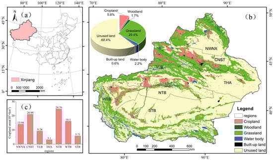
Figure 1.
Geographic location and land use of the study area in 2020: (a) location of Xinjiang, China; (b) distribution of regions in Xinjiang and percentages of land use types in 2020; (c) cropland area in each region. Note: NWNX (Northwestern Northern Xinjiang), CNST (Central Northern Slope of the Tianshan Mountain), YLB (Yili Basin), THA (Turpan–Hami Area), NTB (Northern Tarim Basin), WTB (Western Tarim Basin), and STB (Southern Tarim Basin). The map is based on standard map No. GS (2019) 1822 downloaded from the service website of standard maps, National Administration of Surveying, Mapping and Geoinformation, with no changes in the base map.
2.2. Data Resources and Preprocessing
This study utilizes data on land use, topography, rivers, roads, meteorology, socioeconomics, and saline soil (Table 1). Cropland reclamation and abandonment are influenced by the natural climatic conditions [24,25] and are intricately linked to government policies [26,27] and socioeconomic factors [22,23]. Considering the specific conditions in Xinjiang, this study selects 17 driving factor indicators from six aspects: socioeconomic foundation, socioeconomic changes, accessibility, topography, meteorology, and saline soil (Table 2). Specially, population growth and economic development levels have a significant impact on cropland reclamation and abandonment [22,23]. Population growth increases the food demand [6], driving more land to be reclaimed for agricultural production [43]. In economically robust regions, agricultural inputs [44] (such as fertilizers and mechanization [22]) are significantly increased, thereby promoting cropland reclamation [45]. Conversely, in economically weaker areas, a large portion of rural labor tends to migrate to developed regions for employment [23], leading to cropland abandonment in remote rural areas and the expansion of urban areas into peripheral regions [1]. Accordingly, this study selects the gross domestic product (GDP1 and GDP) and per capita GDP (PGDP1 and PGDP) as indicators to measure the economic base and changes, with agricultural mechanization (TPAM1 and TPAM) representing the intensity of inputs. Topographic factors and meteorological factors significantly influence the land reclamation difficulty and crop growth [24,25]. Studies have shown that steep slopes are challenging for large-scale cropland reclamation [24], and there is a nonlinear and inverted U-shaped relationship between crop yields and meteorological factors [46]. Favorable hydrothermal conditions facilitate land use, whereas unfavorable climates may lead to land abandonment [5]. Therefore, this study selects the digital elevation model (DEM), SLOPE, and ASPECT as topographic indicators and uses the average annual precipitation (PRE) and average annual temperature (TEM) as representative indicators of the meteorological conditions. Xinjiang, with its large per capita cropland area in an arid region, has a high demand for water resources [47]. The accessibility of water sources and improvements in transportation infrastructure may promote cropland reclamation [22], while areas with poor transportation or at greater distances from rivers are more prone to cropland abandonment [48]. Therefore, this study selects the average distance to roads (ROAD) and the average distance to rivers (RIVER) as indicators to measure the accessibility of agricultural markets and the difficulty of water resource acquisition. In arid and semi-arid regions, soil salinization can reduce the efficiency of cropland use, even leading to land abandonment [49,50]. Therefore, this study includes the saline soil area (SALTY and SALTY1) as an additional indicator to assess its impact on cropland changes. These indicators are used to identify the main driving factors of cropland reclamation and abandonment, with statistical analysis based on the 2010 county-level administrative units.

Table 1.
Data description.
Table 2.
Explanatory variables for cropland abandonment and reclamation.
2.3. Methods
2.3.1. Cropland Reclamation Rate and Cropland Abandonment Rate
This study uses the cropland reclamation rate (CRR) and cropland abandonment rate (CAR) [32,51] to quantitatively express the proportion of reclaimed or abandoned cropland areas relative to the baseline cropland area over a given period [52]. In this study, we identify the abandonment and reclamation status for each pixel (30 m) and obtain statistical summaries for the seven sub-regions and county-level administrative units. The calculation formula is
where and represent the rate of cropland reclamation and abandonment, respectively, in region during time period . and represent the cropland reclamation area and abandonment area in region during time period , respectively. represents the cropland area in region in 1980. : 1980–1990, 1990–2000, 2000–2010, 2010–2020.
2.3.2. Center of Gravity Model
To study the temporal changes in the spatial distribution of cropland reclamation and abandonment, this study employs the center of gravity model to describe the distribution comparison and spatial movement process of cropland reclamation and abandonment across different periods [19,21,53]. The calculation formula is
where represents the center of gravity of reclamation (or abandonment), and are the latitude and longitude coordinates of the th reclamation (or abandonment) patch; and is the area of the th reclamation (or abandonment) patch.
2.3.3. Optimal Parameter Geographic Detector Model
The geographical detector is a statistical method used to detect spatially stratified heterogeneity and to reveal its underlying driving factors [54], with fewer constraints regarding homoscedasticity and normality [55]. For the discretization of continuous data, Cao et al. proposed the geographical detector based on optimal parameters. This study employs the optimal parameter geographical detector for factor detection and interaction detection, and it uses the value to measure the explanatory power of the independent variables for the dependent variable [56]. The calculation formula is
where represents the strata of the indicator levels; and are the number of units and variance of the cropland th stratum, respectively; and are the total number of samples and the variance within the study area, respectively. The is within the range of [0, 1], with a higher indicating the stronger explanatory power of the independent variable for the dependent variable, and vice versa [57]. When , it indicates that the independent variable completely controls the spatial distribution of cropland reclamation or abandonment.
3. Results
3.1. Cropland Reclamation and Abandonment Changes
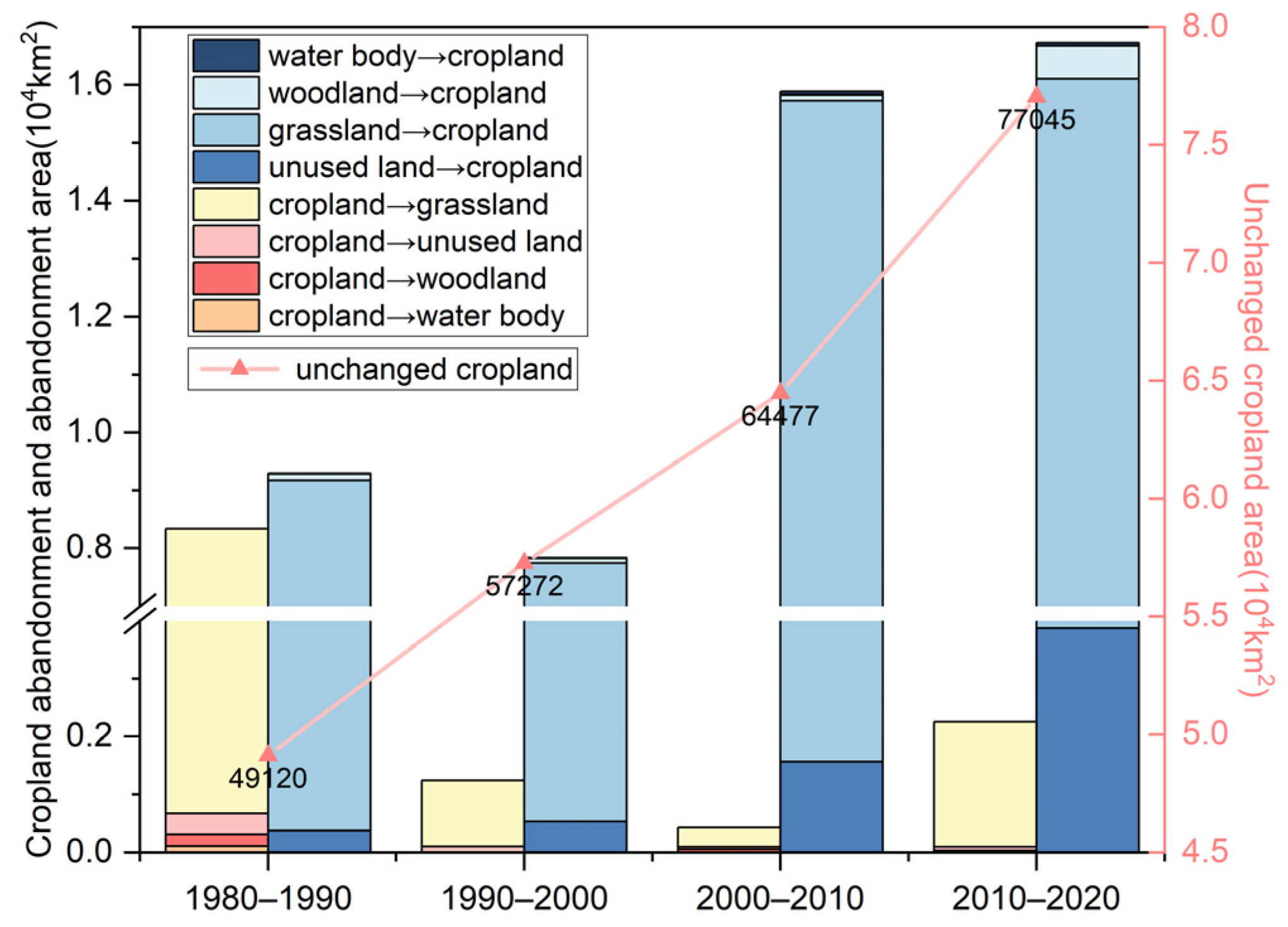
From 1980 to 2020, the cropland area in the study area presented an overall increasing trend. The unchanged cropland area over the four periods also showed a stable upward trend, and the reclaimed cropland area in each period was consistently greater than the abandoned cropland area (Figure 2).
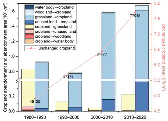
Figure 2.
Area of cropland reclamation and abandonment change types and area of unchanged cropland in Xinjiang in four periods.
From Figure 2 and Table 3, it can be observed that the primary type of land conversion for reclaimed cropland in Xinjiang was from grassland to cropland (GL—CL), with its proportion gradually decreasing from 94.63% to 73.15%. The second major type was from unused land to cropland (UL—CL), with its proportion gradually increasing from 4.06% to 23.13%. For abandoned cropland in Xinjiang, the main type of conversion was from cropland to grassland (CL—GL), followed by cropland to unused land (CL—UL). However, during 2000–2010, conversion from cropland to woodland (CL—WL) significantly increased to 12.01%, while conversion from woodland to cropland (WL—CL) decreased to 0.62%.
Table 3.
Percentage of area with regard to types of changes in cropland reclamation and abandonment in four time periods.
During the study period, the reclamation and abandonment of cropland in Xinjiang exhibited significant spatiotemporal differentiation (Figure 3, Figure 4 and Figure 5). The area and rate of cropland reclamation followed a “V-shaped” trend, characterized by a “slow decrease–rapid increase”, while the area and rate of cropland abandonment followed a “U-shaped” trend, characterized by a “rapid decrease–slow decrease–slow increase”.
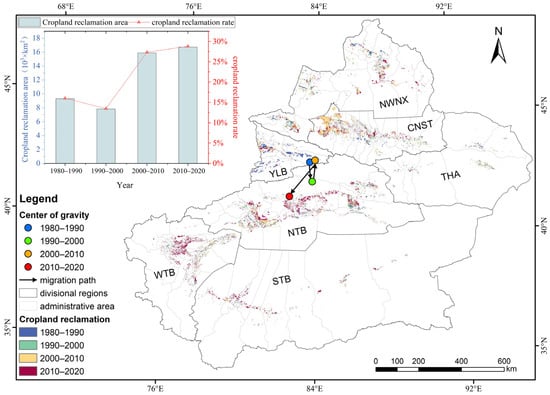
Figure 3.
Spatial distribution of cropland reclamation and its reclamation area and average annual reclamation rate in Xinjiang in different periods. Note: NWNX (Northwestern Northern Xinjiang), CNST (Central Northern Slope of the Tianshan Mountain), YLB (Yili Basin), THA (Turpan–Hami Area), NTB (Northern Tarim Basin), WTB (Western Tarim Basin), and STB (Southern Tarim Basin).
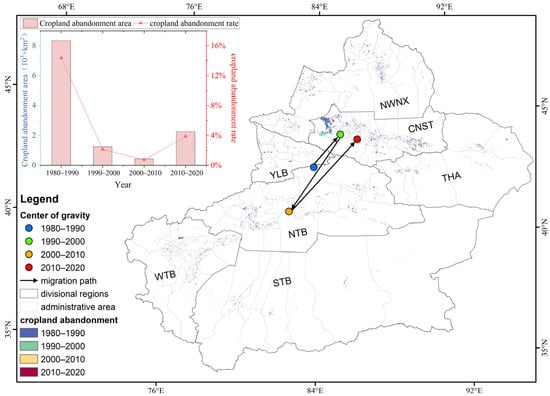
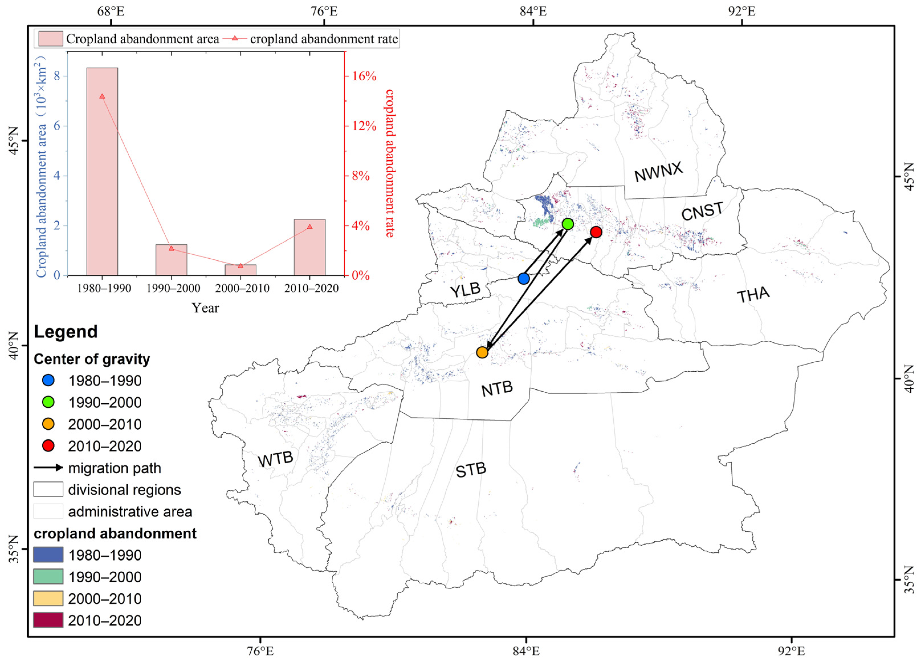
Figure 4.
Spatial distribution of cropland abandonment and its abandonment area and average annual abandonment rate in Xinjiang in different periods. Note: NWNX (Northwestern Northern Xinjiang), CNST (Central Northern Slope of the Tianshan Mountain), YLB (Yili Basin), THA (Turpan–Hami Area), NTB (Northern Tarim Basin), WTB (Western Tarim Basin), and STB (Southern Tarim Basin).
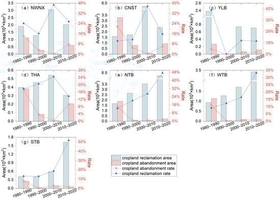
Figure 5.
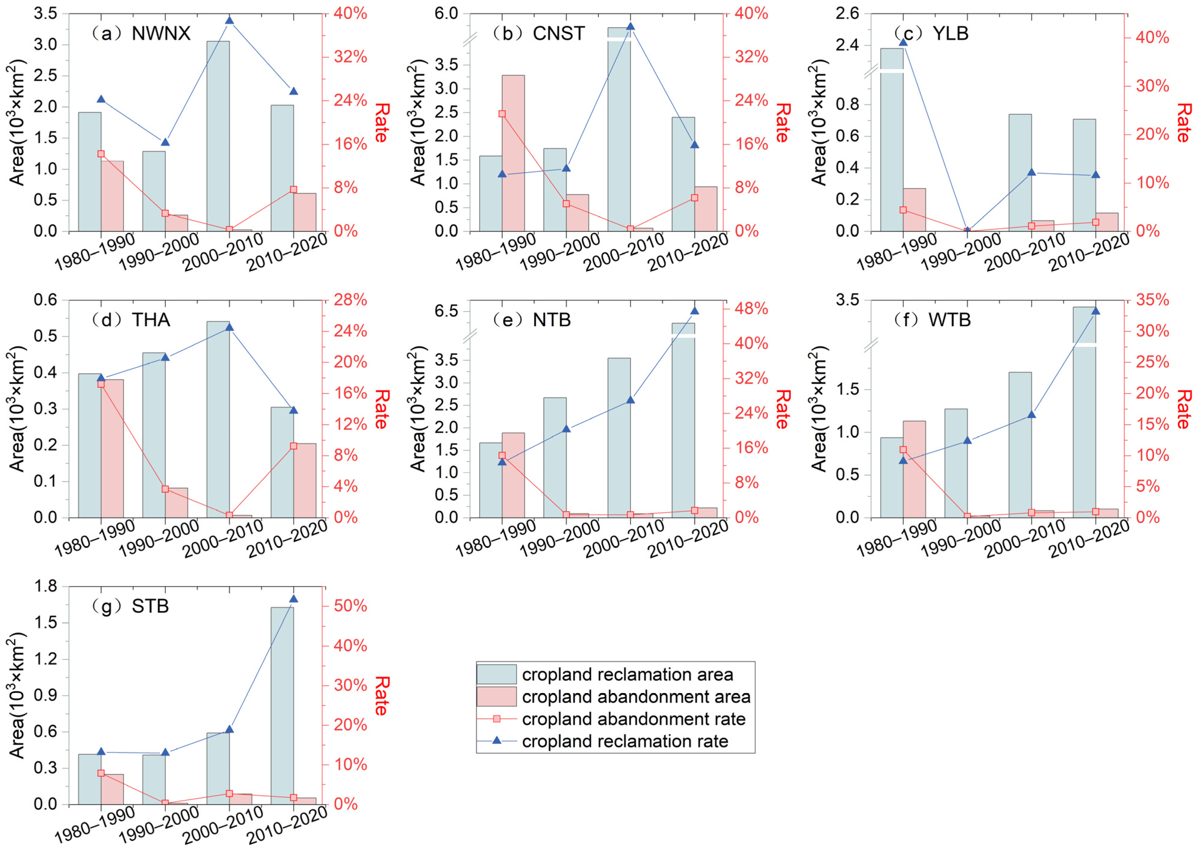
Area and rate of cropland reclamation and abandonment by region in four periods. Note: NWNX (Northwestern Northern Xinjiang), CNST (Central Northern Slope of the Tianshan Mountain), YLB (Yili Basin), THA (Turpan–Hami Area), NTB (Northern Tarim Basin), WTB (Western Tarim Basin), and STB (Southern Tarim Basin).
Xinjiang’s agriculture is predominantly based on oasis irrigation. In terms of spatial distribution, the cropland reclamation areas progressively expanded from the original croplands to the edges, reaching riverbanks, alluvial fans, and the marginal zones of basins. Except for the contiguous abandonment in CNST during the 1980–2000 period, abandoned cropland was generally scattered sporadically.
During the study period, the center of gravity of reclamation and abandonment showed opposite trends, and the high-incidence areas of reclamation and abandonment varied across different periods (Figure 3, Figure 4 and Figure 5). The trajectory of the reclamation center followed a “slightly southeast–slightly northeast–southwest” pattern, while the trajectory of the abandonment center followed a “northeast–southwest–northeast” pattern.
Since 1980, the changes in cropland in Xinjiang have primarily undergone three stages (Figure 3 and Figure 4). The period from 1980 to 1990 was characterized by unstable cropland growth, with the frequent occurrence of both reclamation and abandonment. The main reclamation areas were located in YLB and NWNX, while the main abandonment areas were in CNST and NTB. The period from 1990 to 2010 marked a phase of stable cropland growth, predominantly driven by land reclamation, with a significant reduction in abandonment. The main reclamation areas were located in NTB and CNST, while the primary abandonment areas shifted from CNST and NWNX to NTB and STB. The period from 2010 to 2020 was marked by both cropland growth and constraints. Although land reclamation remained the dominant trend, there was an increase in abandonment. The main reclamation areas were in NTB and WTB, while the primary abandonment areas were in CNST and NWNX.
In the seven sub-regions (Figure 5), the trends of cropland reclamation and abandonment in Xinjiang exhibited significant regional differences and temporal variations. Overall, the southern regions of Xinjiang (NTB, WTB, and STB) showed a gradual increase in the area and rate of cropland reclamation, with the most significant rise occurring during the 2000–2020 period. In contrast, the area and rate of cropland abandonment experienced the most significant decline during the 1980–2000 period, followed by a slight increase, maintaining a relatively stable low level of abandonment. In the northern regions of Xinjiang (NWNX, CNST, YLB, and THA), the area and rate of reclamation exhibited significant volatility, with different characteristics of change in each period across the regions. The area and rate of abandonment showed a trend of an initial decline followed by an increase. Specifically, NWNX, CNST, and THA experienced a declining trend in the first three periods but saw an increase to about 8% during the 2010–2020 period. YLB, on the other hand, maintained a consistently low abandonment rate, with a declining trend during the 1980–2000 period and a slight increase to 2% during the 2000–2020 period.
3.2. Drivers of Cropland Reclamation and Abandonment
Overall, the explanatory power of various driving factors for cropland reclamation was higher compared to that for abandonment (Figure 6). The explanatory power () of these factors for cropland reclamation was relatively higher in the periods 1990–2000 and 2010–2020, with most passing the significance test at p < 0.1. The explanatory power of the dominant factors for cropland abandonment was relatively higher in 2010–2020, showing an overall fluctuating increasing trend.
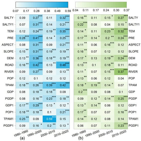
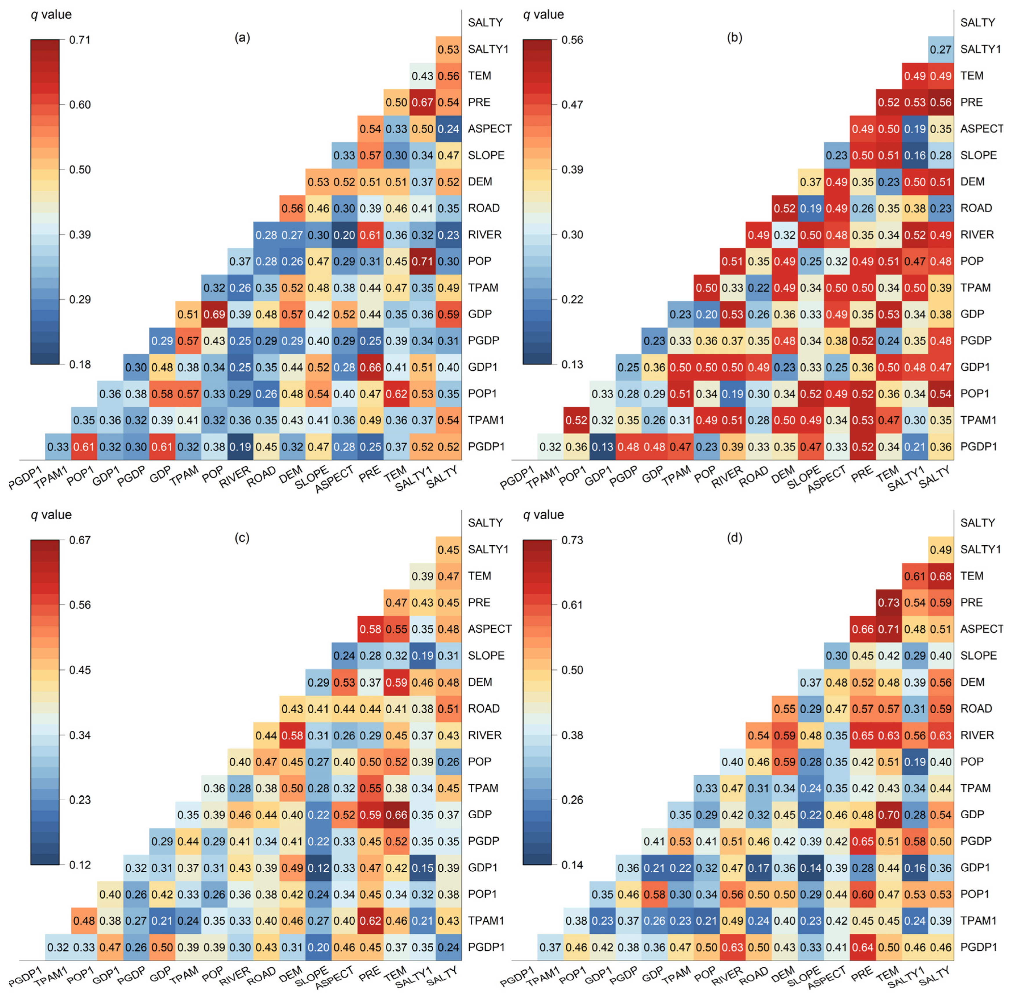
Figure 6.
Maximum q values for each driver in the four periods: (a) cropland reclamation; (b) cropland abandonment. Note: ***, **, * indicate p < 0.01, p < 0.05, p < 0.1, respectively.
The dominant driving factors for cropland reclamation and abandonment exhibited differences across various periods. For cropland reclamation, the influence of the average distance to roads (ROAD) and agricultural mechanization (TPAM) gradually increased, becoming dominant in later periods, while the influence of water resources (precipitation and distance to rivers) and topography factors (DEM, SLOPE, and ASPECT) gradually weakened. For cropland abandonment, the meteorology factors (TEM and PRE) and accessibility factor (RIVER) remained dominant, while the influence of socioeconomic factors (GDP, GDP1, PGDP, and PGDP1), saline soil factors (SALTY and SALTY1), and the population (POP and POP1) gradually decreased, and the influence of agricultural mechanization (TPAM and TPAM1) gradually increased.
Specifically, from 1980 to 1990, the primary driving factor for cropland reclamation was precipitation (PRE, , p < 0.01), followed by the total power of agricultural machinery in 1980 (TPAM1, , p < 0.01). For abandonment, the main driving factor was the proportion of saline soil in the county (SALTY, , p < 0.01), followed by the GDP (, p < 0.01). From 1990 to 2000, the primary driving factors for cropland reclamation were the average distance to roads (ROAD, , p < 0.01) and precipitation (PRE, , p < 0.01). The main driving factors for abandonment were the difference between the total power of agricultural machinery during the period (TPAM, , p < 0.01) and the precipitation (PRE, , p < 0.01). From 2000 to 2010, the primary driving factors for cropland reclamation were the total power of agricultural machinery in 2000 (TPAM1, , p < 0.01) and the difference in the total power of agricultural machinery during the period (TPAM, , p < 0.01). The main driving factors for abandonment were the temperature (TEM, , p < 0.01) and precipitation (PRE, , p < 0.01). From 2010 to 2020, the primary driving factors for cropland reclamation were the average distance to roads (ROAD, , p < 0.01) and the difference in the total power of agricultural machinery during the period (TPAM, , p < 0.01). The main driving factors for abandonment were the average distance to rivers (RIVER, , p < 0.01) and the temperature (TEM, , p < 0.01).
Across the four periods, the explanatory power of two-factor interactions for the reclamation rate was significantly higher than that of individual factors, with most interactions exhibiting a nonlinear enhancement (Figure 7). Over the different time periods, the dominant factors for cropland reclamation shifted from early topographical factors (DEM and SLOPE) and socioeconomic factors (POP and GDP) to being primarily driven by agricultural mechanization (TPAM1 and TPAM) and accessibility factors (ROAD). This reflects the increasing influence of agricultural technological investment and infrastructure development on cropland reclamation.
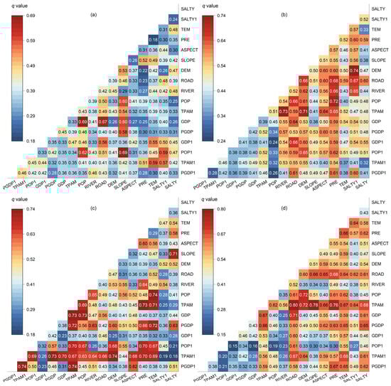
Figure 7.
Results of interaction detector for drivers of cropland reclamation in four periods: (a) 1980–1990; (b) 1990–2000; (c) 2000–2010; (d) 2010–2020.
The dominant interactive factors for cropland reclamation also exhibited variability across the four periods. From 1980 to 1990, cropland reclamation was primarily influenced by the combined effects of the topographic conditions (SLOPE) and socioeconomic factors (POP, POP1 and GDP), exemplified by SLOPE∩POP1 () and POP∩GDP (). From 1990 to 2000, the interactions between the natural geographic factors (DEM and SALTY1) and accessibility (RIVER) and agricultural mechanization (TPAM) were significant, exemplified by DEM∩SALTY1 () and RIVER∩TPAM (). From 2000 to 2010, the combination of the economic development levels (PGDP1) and agricultural mechanization (TPAM1) became the dominant factor, while the topography and temperature also played important roles, as exemplified by PGDP1∩TPAM1 (), TPAM∩PGDP1 (), DEM∩TPAM1, and TEM∩POP (). From 2010 to 2020, the interaction between accessibility (ROAD) and agricultural mechanization (TPAM) was the most significant, with the slope and agricultural mechanization also being important, exemplified by ROAD∩TPAM () and SLOPE∩TPAM ().
Across all four periods, the explanatory power of two-factor interactions for the abandonment rate was significantly higher than that of the single factors, with most interactions exhibiting a nonlinear enhancement (Figure 8). Over the different time periods, the dominant factors influencing cropland abandonment shifted from the population (POP) and saline soil factor (SALTY1) to meteorology factors (PRE and TEM) and agricultural mechanization (TPAM). This shift reflects the increasing impact of climate change and agricultural technology investment on cropland abandonment.

Figure 8.
Results of interaction detector for drivers of cropland abandonment in four periods: (a) 1980–1990; (b) 1990–2000; (c) 2000–2010; (d) 2010–2020.
Across the four periods, the dominant interacting factors influencing cropland abandonment varied. From 1980 to 1990, cropland abandonment was primarily influenced by the interaction between socioeconomic factors (POP and GDP) and saline soil factors (SALTY1), exemplified by POP∩SALTY1 () and GDP∩POP (). From 1990 to 2000, the overall explanatory power was relatively low, mainly influenced by precipitation (PRE) and saline soil factors (SALTY), with the population (POP1) also playing a role, exemplified by PRE∩SALTY () and SALTY∩POP1 (). From 2000 to 2010, the interaction between topographical factors (PRE and TEM) and socioeconomic factors (GDP) and agricultural mechanization (TPAM1) was the most significant. The topographical factor (DEM) and accessibility factor (ROAD) also had an important influence, exemplified by GDP∩TEM () and TPAM1∩PRE (). From 2010 to 2020, the interaction of climate factors (PRE and TEM) was the most significant, with the interaction between the topographical factor (ASPECT) and temperature (TEM) also being important, exemplified by PRE∩TEM () and ASPECT∩TEM ().
4. Discussion
4.1. Spatial and Temporal Patterns of Cropland Reclamation and Abandonment
Analyzing the reclamation and abandonment of cropland in different regions is of great significance in stabilizing a certain amount of cropland and implementing better measures to protect and restore it, which is crucial in ensuring food security. This study provides a high-resolution, long-term analysis of the spatiotemporal characteristics and spatial distribution of cropland reclamation and abandonment in Xinjiang.
Regarding the changing characteristics, previous studies on cropland in Xinjiang primarily focused on either reclamation or abandonment or overall cropland changes [19,58,59,60,61]. These studies typically observed a gradual increase in cropland, which is consistent with our findings. By updating the data and extending the study period to 1980–2020, we uncovered more detailed patterns: since 1980, Xinjiang’s cropland has been characterized mainly by reclamation, with a sharp decline in abandonment and accelerated expansion. Notably, a turning point in reclamation occurred during the 1990–2000 period, followed by rapid growth in reclaimed areas. On the one hand, the gradual improvement of cropland protection policies [1,62], along with the implementation of the Western Development Strategy [63] and the “One Black and One White” strategy (“Black” referring to petroleum and “White” to cotton), ensured the stability and growth of the cropland area. On the other hand, the economic benefits of cropland cultivation during this period became prominent, leading to high local enthusiasm for land development. Conversely, a turning point in cropland abandonment occurred in the 2010–2020 period, primarily due to water resource constraints, resulting in an increase in abandoned land. This water constraint underscores the ongoing challenge of balancing land use intensification with sustainable water resource management, a theme echoed in various studies focused on the environmental limits of agricultural expansion in arid regions [64,65,66].
The coexistence of cropland reclamation and abandonment has become a significant characteristic of LCLUC in Xinjiang [58]. Our study aligned with previous studies, showing a decrease in cropland’s conversion to grassland [4,21], while the transformation of unused land into cropland has increased [67,68]. Uniquely, our study concurrently examined the dynamics of reclamation and abandonment across different regions, along with the migration patterns of their centers of gravity. The center of gravity for reclamation has gradually shifted toward the southern regions (NTB, WTB, and STB), whereas the center for abandonment has moved to the northern regions (NWNX, CNST, YLB, and THA). The trajectories are “slightly southeast to slightly northeast to southwest” for reclamation and “northeast to southwest to northeast” for abandonment. There are several explanations for this trend [4,21]. In the northern regions, an emphasis is placed on ecological construction and economic development, with initiatives like the Grain for Green Program and ecological barrier projects contributing to grassland ecosystem protection [69]. Conversely, the southern regions prioritize agricultural development, with the extensive construction of water conservancy facilities and land leveling, enabling the use of previously unsuitable land for agricultural production.
4.2. Divergent Drivers of Cropland Reclamation and Abandonment
The main driving factors of cropland reclamation and abandonment vary across different development stages. This study employs the optimal parameter geographic detector to quantify the impact of various driving forces on the dynamic changes in cropland reclamation and abandonment and incorporates the interactions between dual factors.
Regarding the driving factors of cropland reclamation, previous studies have typically focused on specific periods and found irrigation conditions as the primary driving force, with population growth also playing important roles [70]. Our study provided a more comprehensive analysis by examining the dominant factors across four different periods. Specifically, in the 1980–2000 period, precipitation was identified as the key driver of cropland reclamation, while the GDP and population growth were recognized as significant influencing factors, consistent with the findings from other studies. Our study also indicated that the limiting effects of water resources (such as PRE and RIVER) and topographical factors on cropland reclamation are gradually weakening, while the influence of agricultural mechanization (such as TPAM) and the proximity to roads is increasing. One explanation for this phenomenon is that abandonment frequently occurs in areas where the natural conditions are unfavorable for cultivation [71]. Before 2000, the proportion of irrigation facilities in the arid land of Northwest China was low, and the overall quality of field projects was not high [59], causing water and soil resources to significantly impact cropland reclamation [18]. Over the past decade, numerous water conservancy projects have been constructed in Xinjiang, and advanced irrigation methods such as sprinkler, drip, and micro-irrigation have been widely adopted [72], providing agricultural irrigation water tailored to different crops, counties, and irrigation cycles. Additionally, the development of agricultural mechanization and the proximity to roads have facilitated unified mechanized management and cost efficiency, making residents more inclined to cultivate [73]. Furthermore, large-scale land development and consolidation projects have been extensively promoted in Xinjiang. In some areas, land leveling and the establishment of irrigation and drainage facilities have been achieved, laying a solid foundation for large-scale agricultural development [74].
Regarding the driving factors of cropland abandonment, previous studies have found population growth and socioeconomic variables as influential factors [32]. Our study indicated a notable shift in the primary drivers of abandonment. Historically, factors such as saline soil, the GDP, and the availability of agricultural machinery were predominant [70]. However, our findings revealed that the most significant drivers have evolved to include meteorological conditions (temperature and precipitation) as well as accessibility factors (the distance to rivers). Several explanations exist for this phenomenon. Firstly, certain engineering measures, such as establishing drainage systems and implementing scientific irrigation, along with planting salt-tolerant crops, have reduced the impact of saline soil on cropland abandonment [75,76,77]. These measures have allowed for more sustainable land use, even in areas where the soil salinity previously posed significant challenges. Secondly, although previous studies have shown that rural labor in economically underdeveloped areas tends to abandon cropland, the recent increase in the economic benefits of crop cultivation has, to some extent, stimulated farmers’ enthusiasm for grain production [26,78,79]. Furthermore, as Xinjiang’s policies and agricultural development increasingly favor the economically and naturally disadvantaged regions of Southern Xinjiang, the existing cropland, constrained by the arid climate and inadequate cropland infrastructure, has become more sensitive to climate change and the proximity to rivers [58].
In the interaction of two factors, agricultural technological investment and infrastructure development increasingly influence cropland reclamation, while climate change and technological investment impact cropland abandonment. As technology alleviates traditional constraints, new challenges related to climate change and resource availability emerge. Future research should develop adaptive land management strategies that respond to these shifting dynamics, ensuring long-term agricultural sustainability. By understanding these changes, policymakers can design interventions that promote sustainable development and address environmental degradation and resource scarcities.
4.3. Limitations and Future Directions
Firstly, the temporal resolution and spatial resolution of the land use data are 10 years and 30 m, respectively. This results in the study overlooking changes in cropland reclamation and abandonment–recultivation processes within the decade. Furthermore, it does not account for the variability in the land use area within individual pixels, leading to inaccuracies in the evaluation of the reclamation and abandonment results. Secondly, the smallest research unit in this study does not distinguish between the land use impacts of local administrative areas and those of the Xinjiang Production and Construction Corps (XPCC). In addition, regarding the driving factors of abandonment and reclamation, policies are difficult to quantify spatially and temporally. Moreover, the utilization of water resources in arid land significantly impacts land reclamation and abandonment, but conducting a quantitative analysis of regional water resource matching is challenging. Future research could explore other methods to incorporate policies into the explanatory framework of the driving forces behind cropland reclamation and abandonment, to understand these driving mechanisms more scientifically.
5. Conclusions
This study, based on Xinjiang’s cropland data from 1980 to 2020 across four periods, investigates the spatial patterns and regional differences in cropland reclamation and abandonment in the four periods. Furthermore, using an optimized geographical detector model, the study examines the driving factors of cropland reclamation and abandonment over different periods from six perspectives: socioeconomic foundation, socioeconomic changes, accessibility, topographical, meteorological, and saline soil. The main conclusions are as follows.
- (1)
- Since 1980, the cropland area in Xinjiang has shown a stable increasing trend, despite the large-scale reclamation of grassland and cropland abandonment. The area and rate of cropland reclamation show a “V-shaped” upward trend, while the area and rate of cropland abandonment show a “U-shaped” downward trend. The changes in Xinjiang’s cropland have undergone three main stages: 1980–1990, characterized by unstable growth with frequent reclamation and abandonment; 1990–2010, marked by stable growth with a significant reduction in abandonment; and 2010–2020, a period of coexisting growth and constraints, still dominated by reclamation but with some increase in abandonment.
- (2)
- Cropland reclamation and abandonment in Xinjiang exhibited significant spatiotemporal differentiation, both overall and across the sub-regions. The center of gravity of cropland reclamation moved “slightly southeast–slightly northeast–southwest”, while the center of gravity of abandonment shifted “northeast–southwest–northeast”. The southern regions (NTB, WTB, and STB) showed a steady rise in cropland reclamation, with the declining abandonment rates stabilizing after 2000. In contrast, the northern regions (NWNX, CNST, YLB, and THA) showed volatile reclamation and fluctuating abandonment rates.
- (3)
- The primary driving factors of cropland reclamation and abandonment vary across development stages. Over time, the influence of agricultural technological investment and infrastructure improvements on reclamation has increased, while the relative importance of natural environmental factors (such as precipitation, distance to rivers, and topography) has declined. The climatic conditions (temperature, precipitation) and water accessibility (average distance to rivers) remain crucial in determining cropland abandonment, but the impact of economic and social factors has weakened, and the influence of agricultural mechanization has grown.
Author Contributions
Conceptualization, Y.F. and S.W.; methodology, Y.F.; software, Y.F.; resources, S.W.; data curation, Y.F.; writing—original draft preparation, Y.F. and W.L.; writing—review and editing, Y.F., S.W. and G.H.; visualization, Y.F. All authors have read and agreed to the published version of the manuscript.
Funding
This research was funded by the Strategic Priority Research Program of Chinese Academy of Sciences, grant number XDA23100201.
Data Availability Statement
The data that support the findings of this study are available from the first author upon reasonable request.
Conflicts of Interest
The authors declare no conflicts of interest.
References
- Huang, Z.; Du, X.; Castillo, C.S.Z. How Does Urbanization Affect Farmland Protection? Evidence from China. Resour. Conserv. Recycl. 2019, 145, 139–147. [Google Scholar] [CrossRef]
- Chen, W.-G.; Kong, X.-B. Science and Technology Innovation Strategy for Cultivated Land Conservation of China. Chin. J. Soil Sci. 2023, 54, 947–954. [Google Scholar] [CrossRef]
- Olsen, V.M.; Fensholt, R.; Olofsson, P.; Bonifacio, R.; Butsic, V.; Druce, D.; Ray, D.; Prishchepov, A.V. The Impact of Conflict-Driven Cropland Abandonment on Food Insecurity in South Sudan Revealed Using Satellite Remote Sensing. Nat. Food 2021, 2, 990–996. [Google Scholar] [CrossRef]
- Chai, L.; Liu, A.; Li, X.; Guo, Z.; He, W.; Huang, J.; Bai, T.; Liu, J. Telecoupled Impacts of the Russia–Ukraine War on Global Cropland Expansion and Biodiversity. Nat. Sustain. 2024, 7, 432–441. [Google Scholar] [CrossRef]
- Wheeler, T.; von Braun, J. Climate Change Impacts on Global Food Security. Science 2013, 341, 508–513. [Google Scholar] [CrossRef]
- Kong, L.; Wu, T.; Xiao, Y.; Xu, W.; Zhang, X.; Daily, G.C.; Ouyang, Z. Natural Capital Investments in China Undermined by Reclamation for Cropland. Nat. Ecol. Evol. 2023, 7, 1771–1777. [Google Scholar] [CrossRef]
- Kehoe, L.; Romero-Muñoz, A.; Polaina, E.; Estes, L.; Kreft, H.; Kuemmerle, T. Biodiversity at Risk under Future Cropland Expansion and Intensification. Nat. Ecol. Evol. 2017, 1, 1129–1135. [Google Scholar] [CrossRef]
- Pendrill, F.; Gardner, T.A.; Meyfroidt, P.; Persson, U.M.; Adams, J.; Azevedo, T.; Bastos Lima, M.G.; Baumann, M.; Curtis, P.G.; De Sy, V.; et al. Disentangling the Numbers behind Agriculture-Driven Tropical Deforestation. Science 2022, 377, eabm9267. [Google Scholar] [CrossRef]
- Lark, T.J.; Spawn, S.A.; Bougie, M.; Gibbs, H.K. Cropland Expansion in the United States Produces Marginal Yields at High Costs to Wildlife. Nat. Commun. 2020, 11, 4295. [Google Scholar] [CrossRef]
- Fan, Z.L.; Wu, S.X.; Wu, Y.; Zhang, P.; Zhao, X.F.; Zhang, J. The Land Reclamation in Xinjiang since the Founding of New China. J. Nat. Resour. 2013, 28, 713–720. [Google Scholar] [CrossRef]
- HU, R.J.; Ma, H.; Fan, Z.L.; Yang, Q.; Wu, S.F.; Huang, Y.Y. Response of Water Resources to Climate Change in Xinjiang. J. Nat. Resour. 2002, 17, 22–27. [Google Scholar] [CrossRef]
- Zhu, H.; Li, Y. An Empirical Analysis of the Causes of Farmland Expansion in Northwest China. Prog. Geogr. 2011, 30, 615–620. [Google Scholar] [CrossRef]
- Jin, X.; Cao, X.; Du, X.; Yang, X.; Bai, Q.; Zhou, Y. Farmland Dataset Reconstruction and Farmland Change Analysis in China during 1661–1985. J. Geogr. Sci. 2015, 25, 1058–1074. [Google Scholar] [CrossRef]
- Wu, T.J.; Luo, J.C.; Zhang, X.; Dong, W.; Huang, Q.T.; Zhou, Y.N.; Liu, W.; Sun, Y.W.; Yang, Y.P.; Hu, X.D.; et al. Remote Sensing Granular Computing and Precise Applications Based on Geo-Parcels. Natl. Remote Sens. Bull. 2023, 27, 2774–2795. [Google Scholar] [CrossRef]
- Zhang, Q.; Luo, G.; Li, L.; Zhang, M.; Lv, N.; Wang, X. An Analysis of Oasis Evolution Based on Land Use and Land Cover Change: A Case Study in the Sangong River Basin on the Northern Slope of the Tianshan Mountains. J. Geogr. Sci. 2017, 27, 223–239. [Google Scholar] [CrossRef]
- Zhao, R.F.; Chen, Y.N.; Li, W.H.; Zhang, L.H.; Wu, S.X.; Huang, Q. Land Cover Change and Landscape Pattern in the Mainstream of the Tarim River. Acta Geogr. Sin. 2009, 64, 95–106. [Google Scholar]
- Xu, Z.; Fan, W.; Wei, H.; Zhang, P.; Ren, J.; Gao, Z.; Ulgiati, S.; Kong, W.; Dong, X. Evaluation and Simulation of the Impact of Land Use Change on Ecosystem Services Based on a Carbon Flow Model: A Case Study of the Manas River Basin of Xinjiang, China. Sci. Total Environ. 2019, 652, 117–133. [Google Scholar] [CrossRef]
- Chen, H.; Wu, S.; Feng, X. Study on the Changes of Cultivated Land and the Driving Factors in Xinjiang: Based on RS and GIS. J. Nat. Resour. 2010, 25, 614–624. [Google Scholar] [CrossRef]
- Gao, X.; Cheng, W.; Wang, N.; Liu, Q.; Ma, T.; Chen, Y.; Zhou, C. Spatio-Temporal Distribution and Transformation of Cropland in Geomorphologic Regions of China during 1990–2015. J. Geogr. Sci. 2019, 29, 180–196. [Google Scholar] [CrossRef]
- Xu, H.; Yong, N.; Xia, X.; Sheng, J.; Yili, Z. Monitoring Land-Use Change in Hetian Tarim Basin, China Using Satellite Remote Sensing Observation between 1990 and 2016. Prog. Geogr. 2020, 39, 577–590. [Google Scholar]
- Cai, T.; Zhang, X.; Xia, F.; Zhang, Z.; Yin, J.; Wu, S. The Process-Mode-Driving Force of Cropland Expansion in Arid Regions of China Based on the Land Use Remote Sensing Monitoring Data. Remote Sens. 2021, 13, 2949. [Google Scholar] [CrossRef]
- Meyfroidt, P.; Schierhorn, F.; Prishchepov, A.V.; Müller, D.; Kuemmerle, T. Drivers, Constraints and Trade-Offs Associated with Recultivating Abandoned Cropland in Russia, Ukraine and Kazakhstan. Glob. Environ. Chang. 2016, 37, 1–15. [Google Scholar] [CrossRef]
- Hou, D.; Meng, F.; Prishchepov, A.V. How Is Urbanization Shaping Agricultural Land-Use? Unraveling the Nexus between Farmland Abandonment and Urbanization in China. Landsc. Urban Plan. 2021, 214, 104170. [Google Scholar] [CrossRef]
- Arnaez, J.; Lasanta, T.; Errea, M.P.; Ortigosa, L. Land Abandonment, Landscape Evolution, and Soil Erosion in a Spanish Mediterranean Mountain Region: The Case of Camero Viejo. Land Degrad. Dev. 2011, 22, 537–550. [Google Scholar] [CrossRef]
- Shi, W.; Tao, F.; Liu, J.; Xu, X.; Kuang, W.; Dong, J.; Shi, X. Has Climate Change Driven Spatio-Temporal Changes of Cropland in Northern China since the 1970s? Clim. Chang. 2014, 124, 163–177. [Google Scholar] [CrossRef]
- Zhang, Y.; Li, X.; Song, W. Determinants of Cropland Abandonment at the Parcel, Household and Village Levels in Mountain Areas of China: A Multi-Level Analysis. Land Use Policy 2014, 41, 186–192. [Google Scholar] [CrossRef]
- Han, Z.; Song, W. Abandoned Cropland: Patterns and Determinants within the Guangxi Karst Mountainous Area, China. Appl. Geogr. 2020, 122, 102245. [Google Scholar] [CrossRef]
- Wu, B.; Fu, Z.; Fu, B.; Yan, C.; Zeng, H.; Zhao, W. Dynamics of Land Cover Changes and Driving Forces in China’s Drylands since the 1970 s. Land Use Policy 2024, 140, 107097. [Google Scholar] [CrossRef]
- Cai, H.; Wang, Z.; Du, G.; Zhang, D. Assessing the Impacts of Rural Residential Land and Cropland Transition on Agricultural Production in Northeast China. Food Energy Secur. 2023, 12, e482. [Google Scholar] [CrossRef]
- Zhong, Y.; Sun, J.; Wang, Q.; Ou, D.; Tian, Z.; Yu, W.; Li, P.; Gao, X. Spatiotemporal Distribution and Driving Mechanisms of Cropland Long-Term Stability in China from 1990 to 2018. Land 2024, 13, 1016. [Google Scholar] [CrossRef]
- Chen, Y.; Li, X.; Liu, X.; Ai, B.; Li, S. Capturing the Varying Effects of Driving Forces over Time for the Simulation of Urban Growth by Using Survival Analysis and Cellular Automata. Landsc. Urban Plan. 2016, 152, 59–71. [Google Scholar] [CrossRef]
- Guo, A.; Yue, W.; Yang, J.; Xue, B.; Xiao, W.; Li, M.; He, T.; Zhang, M.; Jin, X.; Zhou, Q. Cropland Abandonment in China: Patterns, Drivers, and Implications for Food Security. J. Clean. Prod. 2023, 418, 138154. [Google Scholar] [CrossRef]
- Chen, Y.; Li, W.; Deng, H.; Fang, G.; Li, Z. Changes in Central Asia’s Water Tower: Past, Present and Future. Sci. Rep. 2016, 6, 35458. [Google Scholar] [CrossRef]
- Yao, J.; Mao, W.; Chen, J.; Dilinuer, T. Recent Signal and Impact of Wet-to-Dry Climatic Shift in Xinjiang, China. J. Geogr. Sci. 2021, 31, 1283–1298. [Google Scholar] [CrossRef]
- Ding, Y.; Liu, Y.; Xu, Y.; Wu, P.; Xue, T.; Wang, J.; Shi, Y.; Zhang, Y.; Song, Y.; Wang, P. Regional Responses to Global Climate Change: Progress and Prospects for Trend, Causes, and Projection of Climatic Warming-Wetting in Northwest China. Adv. Earth Sci. 2023, 38, 551. [Google Scholar] [CrossRef]
- Chuai, X.; Huang, X.; Wu, C.; Li, J.; Lu, Q.; Qi, X.; Zhang, M.; Zuo, T.; Lu, J. Land Use and Ecosystems Services Value Changes and Ecological Land Management in Coastal Jiangsu, China. Habitat Int. 2016, 57, 164–174. [Google Scholar] [CrossRef]
- Liu, J.; Zhang, Z.; Xu, X.; Kuang, W.; Zhou, W.; Zhang, S.; Li, R.; Yan, C.; Yu, D.; Wu, S.; et al. Spatial Patterns and Driving Forces of Land Use Change in China during the Early 21st Century. J. Geogr. Sci. 2010, 20, 483–494. [Google Scholar] [CrossRef]
- Liu, J.Y.; Liu, M.L.; Deng, X.Z.; Zhuang, D.F.; Zhang, Z.X.; Luo, D. The Land Use and Land Cover Change Database and Its Relative Studies in China. J. Geogr. Sci. 2002, 12, 275–282. [Google Scholar] [CrossRef]
- Liu, F.; Yan, H.M.; Liu, J.Y.; Xiao, X.; Qin, Y.W. Spatial Pattern of Land Use Intensity in China in 2000. Acta Geogr. Sin. 2016, 71, 1130–1143. [Google Scholar] [CrossRef]
- Ning, J.; Liu, J.; Kuang, W.; Xu, X.; Zhang, S.; Yan, C.; Li, R.; Wu, S.; Hu, Y.; Du, G.; et al. Spatiotemporal Patterns and Characteristics of Land-Use Change in China during 2010–2015. J. Geogr. Sci. 2018, 28, 547–562. [Google Scholar] [CrossRef]
- Kuang, W.H.; Zhang, S.W.; Du, G.M.; Yan, C.Z.; Wu, S.X.; Li, R.D.; Lu, D.S.; Pan, T.; Ning, J.; Guo, C.Q. Remotely Sensed Mapping and Analysis of Spatio-Temporal Patterns of Land Use Change across China in 2015–2020. Acta Geogr. Sin. 2022, 77, 1056–1071. [Google Scholar] [CrossRef]
- Zhang, M.; Li, G.; He, T.; Zhai, G.; Guo, A.; Chen, H.; Wu, C. Reveal the Severe Spatial and Temporal Patterns of Abandoned Cropland in China over the Past 30 Years. Sci. Total Environ. 2023, 857, 159591. [Google Scholar] [CrossRef]
- Xu, F.; Wang, Z.; Chi, G.; Zhang, Z. The Impacts of Population and Agglomeration Development on Land Use Intensity: New Evidence behind Urbanization in China. Land Use Policy 2020, 95, 104639. [Google Scholar] [CrossRef]
- Movahedi, R.; Jawanmardi, S.; Azadi, H.; Goli, I.; Viira, A.-H.; Witlox, F. Why Do Farmers Abandon Agricultural Lands? The Case of Western Iran. Land Use Policy 2021, 108, 105588. [Google Scholar] [CrossRef]
- Wang, S.; Tan, S.; Yang, S.; Lin, Q.; Zhang, L. Urban-Biased Land Development Policy and the Urban-Rural Income Gap: Evidence from Hubei Province, China. Land Use Policy 2019, 87, 104066. [Google Scholar] [CrossRef]
- Chen, S.; Chen, X.; Xu, J. Impacts of Climate Change on Agriculture: Evidence from China. J. Environ. Econ. Manag. 2016, 76, 105–124. [Google Scholar] [CrossRef]
- Wang, Z.; Sun, S. Transportation Infrastructure and Rural Development in China. China Agric. Econ. Rev. 2016, 8, 516–525. [Google Scholar] [CrossRef]
- Prishchepov, A.V.; Müller, D.; Dubinin, M.; Baumann, M.; Radeloff, V.C. Determinants of Agricultural Land Abandonment in Post-Soviet European Russia. Land Use Policy 2013, 30, 873–884. [Google Scholar] [CrossRef]
- Yang, H.; Zhang, F.; Chen, Y.; Xu, T.; Cheng, Z.; Liang, J. Assessment of Reclamation Treatments of Abandoned Farmland in an Arid Region of China. Sustainability 2016, 8, 1183. [Google Scholar] [CrossRef]
- Hussain, S.; Shaukat, M.; Ashraf, M.; Zhu, C.; Jin, Q.; Zhang, J.; Hussain, S.; Shaukat, M.; Ashraf, M.; Zhu, C.; et al. Salinity Stress in Arid and Semi-Arid Climates: Effects and Management in Field Crops. In Climate Change and Agriculture; IntechOpen: London, UK, 2019; ISBN 978-1-78985-668-2. [Google Scholar]
- Liu, B.; Song, W. Mapping Abandoned Cropland Using Within-Year Sentinel-2 Time Series. CATENA 2023, 223, 106924. [Google Scholar] [CrossRef]
- Xiao, G.; Zhu, X.; Hou, C.; Xia, X. Extraction and Analysis of Abandoned Farmland: A Case Study of Qingyun and Wudi Counties in Shandong Province. J. Geogr. Sci. 2019, 29, 581–597. [Google Scholar] [CrossRef]
- Zuo, L.; Zhang, Z.; Zhao, X.; Wang, X.; Wu, W.; Yi, L.; Liu, F. Multitemporal Analysis of Cropland Transition in a Climate-Sensitive Area: A Case Study of the Arid and Semiarid Region of Northwest China. Reg. Environ. Chang. 2014, 14, 75–89. [Google Scholar] [CrossRef]
- Wang, J.; Li, X.; Christakos, G.; Liao, Y.; Zhang, T.; Gu, X.; Zheng, X. Geographical Detectors-Based Health Risk Assessment and Its Application in the Neural Tube Defects Study of the Heshun Region, China. Int. J. Geogr. Inf. Sci. 2010, 24, 107–127. [Google Scholar] [CrossRef]
- Ding, Y.; Cai, J.M.; Ren, Z.P.; Yang, Z. Spatial Disparities of Economic Growth Rate of China’s National-Level ETDZs and Their Determinants Based on Geographical Detector Analysis. Prog. Geogr. 2014, 33, 657–666. [Google Scholar] [CrossRef]
- Cao, F.; Ge, Y.; Wang, J.-F. Optimal Discretization for Geographical Detectors-Based Risk Assessment. GISci. Remote Sens. 2013, 50, 78–92. [Google Scholar] [CrossRef]
- Wang, J.; Xu, C. Geodetector: Principle and Prospective. Acta Geogr. Sin. 2017, 72, 116–134. [Google Scholar] [CrossRef]
- Liu, J.; Kuang, W.; Zhang, Z.; Xu, X.; Qin, Y.; Ning, J.; Zhou, W.; Zhang, S.; Li, R.; Yan, C.; et al. Spatiotemporal Characteristics, Patterns, and Causes of Land-Use Changes in China since the Late 1980s. J. Geogr. Sci. 2014, 24, 195–210. [Google Scholar] [CrossRef]
- Zuo, L.; Zhang, Z.; Carlson, K.M.; MacDonald, G.K.; Brauman, K.A.; Liu, Y.; Zhang, W.; Zhang, H.; Wu, W.; Zhao, X.; et al. Progress towards Sustainable Intensification in China Challenged by Land-Use Change. Nat. Sustain. 2018, 1, 304–313. [Google Scholar] [CrossRef]
- Cheng, H.; Wang, X.; Chen, D. Research on Spatial-Temporal Variations of Cultivated Land in China Based on GlobeLand30. Front. Environ. Sci. 2022, 10, 929760. [Google Scholar] [CrossRef]
- Potapov, P.; Turubanova, S.; Hansen, M.C.; Tyukavina, A.; Zalles, V.; Khan, A.; Song, X.-P.; Pickens, A.; Shen, Q.; Cortez, J. Global Maps of Cropland Extent and Change Show Accelerated Cropland Expansion in the Twenty-First Century. Nat. Food 2022, 3, 19–28. [Google Scholar] [CrossRef]
- Lichtenberg, E.; Ding, C. Assessing Farmland Protection Policy in China. Land Use Policy 2008, 25, 59–68. [Google Scholar] [CrossRef]
- Li, X.; Chen, Y.; Xu, L.; Li, P.; Zhang, R. Transformation of Farmland Use and Driving Mechanism in Xinjiang since China’s Western Development Policy. Front. Ecol. Evol. 2022, 10, 942065. [Google Scholar] [CrossRef]
- García-Ruiz, J.M.; Lana-Renault, N. Hydrological and Erosive Consequences of Farmland Abandonment in Europe, with Special Reference to the Mediterranean Region—A Review. Agric. Ecosyst. Environ. 2011, 140, 317–338. [Google Scholar] [CrossRef]
- Yan, X.; Wang, Y.; Chen, Y.; Yang, G.; Xia, B.; Xu, H. Study on the Spatial Allocation of Receding Land and Water Reduction under Water Resource Constraints in Arid Zones. Agriculture 2022, 12, 926. [Google Scholar] [CrossRef]
- Jiang, C.; Zhang, H.; Wang, X.; Feng, Y.; Labzovskii, L. Challenging the Land Degradation in China’s Loess Plateau: Benefits, Limitations, Sustainability, and Adaptive Strategies of Soil and Water Conservation. Ecol. Eng. 2019, 127, 135–150. [Google Scholar] [CrossRef]
- Tan, Y.; Wu, C.; Wang, Q.; Zhou, L.; Yan, D. The change of cultivated land and ecological environment effects driven by the policy of dynamic equilibrium of the total cultivated land. J. Nat. Resour. 2005, 20, 727–734. [Google Scholar] [CrossRef]
- Li, C.; Fu, B.; Wang, S.; Stringer, L.C.; Wang, Y.; Li, Z.; Liu, Y.; Zhou, W. Drivers and Impacts of Changes in China’s Drylands. Nat. Rev. Earth Environ. 2021, 2, 858–873. [Google Scholar] [CrossRef]
- Shidong, L.I.; Moucheng, L.I.U. The Development Process, Current Situation and Prospects of the Conversion of Farmland to Forests and Grasses Project in China. J. Resour. Ecol. 2022, 13, 120–128. [Google Scholar] [CrossRef]
- Ramankutty, N.; Mehrabi, Z.; Waha, K.; Jarvis, L.; Kremen, C.; Herrero, M.; Rieseberg, L.H. Trends in Global Agricultural Land Use: Implications for Environmental Health and Food Security. Annu. Rev. Plant Biol. 2018, 69, 789–815. [Google Scholar] [CrossRef]
- Hinojosa, L.; Napoléone, C.; Moulery, M.; Lambin, E.F. The “Mountain Effect” in the Abandonment of Grasslands: Insights from the French Southern Alps. Agric. Ecosyst. Environ. 2016, 221, 115–124. [Google Scholar] [CrossRef]
- Chauhdary, J.N.; Li, H.; Jiang, Y.; Pan, X.; Hussain, Z.; Javaid, M.; Rizwan, M. Advances in Sprinkler Irrigation: A Review in the Context of Precision Irrigation for Crop Production. Agronomy 2024, 14, 47. [Google Scholar] [CrossRef]
- Zhang, P.; Xia, L.; Sun, Z.; Zhang, T. Analysis of Spatial and Temporal Changes and Driving Forces of Arable Land in the Weibei Dry Plateau Region in China. Sci. Rep. 2023, 13, 20618. [Google Scholar] [CrossRef] [PubMed]
- Wang, S.; Bai, X.; Zhang, X.; Reis, S.; Chen, D.; Xu, J.; Gu, B. Urbanization Can Benefit Agricultural Production with Large-Scale Farming in China. Nat. Food 2021, 2, 183–191. [Google Scholar] [CrossRef]
- Matlock, W.G.; Matlock, W.G. Realistic Planning for Arid Lands: Natural Resource Limitations to Agricultural Development; CRC Press: Boca Raton, FL, USA, 1981; Volume 2, ISBN 3-7186-0051-X. [Google Scholar]
- Stricker, P. Toward a Culture of Nature: Environmental Policy and Sustainable Development in Cuba; Lexington Books: Lanham, MD, USA, 2007; ISBN 978-0-7391-2023-1. [Google Scholar]
- Gupta, I.C.; Gupta, S.K. Crop Production in Waterlogged Saline Soils; Scientific Publishers: Jodhpur, India, 2018; ISBN 978-81-7233-159-7. [Google Scholar]
- Yan, J.; Yang, Z.; Li, Z.; Li, X.; Xin, L.; Sun, L. Drivers of Cropland Abandonment in Mountainous Areas: A Household Decision Model on Farming Scale in Southwest China. Land Use Policy 2016, 57, 459–469. [Google Scholar] [CrossRef]
- Zhou, T.; Koomen, E.; Ke, X. Determinants of Farmland Abandonment on the Urban–Rural Fringe. Environ. Manag. 2020, 65, 369–384. [Google Scholar] [CrossRef]


Disclaimer/Publisher’s Note: The statements, opinions and data contained in all publications are solely those of the individual author(s) and contributor(s) and not of MDPI and/or the editor(s). MDPI and/or the editor(s) disclaim responsibility for any injury to people or property resulting from any ideas, methods, instructions or products referred to in the content. |
© 2024 by the authors. Licensee MDPI, Basel, Switzerland. This article is an open access article distributed under the terms and conditions of the Creative Commons Attribution (CC BY) license (https://creativecommons.org/licenses/by/4.0/).