Article

Spatiotemporal Coupling Evolution Characteristics and Driving Mechanisms of Corn Cultivation and Pig Farming in China

1
School of Government, Beijing Normal University, Beijing 100875, China
2
Faculty of Education, Beijing Normal University, Beijing 100875, China
*
Authors to whom correspondence should be addressed.
Land 2025, 14(4), 806; https://doi.org/10.3390/land14040806
Submission received: 1 March 2025 / Revised: 28 March 2025 / Accepted: 3 April 2025 / Published: 9 April 2025

Abstract

:
Corn and pig farming are representative sectors of China’s crop production and livestock industries, respectively. The spatial relationship between these two industries is of great significance for coordinating crop–livestock integration and promoting sustainable agricultural development. Therefore, this study takes corn and pig farming as focal points to examine the spatiotemporal coupling and evolutionary characteristics of these two industries and to identify the driving mechanisms underlying their spatiotemporal coupling relationship. The study results showed the following: (1) The production center for pigs is situated in southern China, whereas the corn production center is located in northern China. Temporally, the corn production center continues to shift northward, while the location of the pig production center remains relatively stable. (2) The national-level coupling development index for corn and pigs exhibits a declining trend with fluctuations and significant regional disparities. The lowest coupling development index is observed in northeastern China. (3) The “corn–pig” production balance coefficient categorizes northern regions as “more grain, fewer pigs” and southern regions as “more pigs, fewer grains”, demonstrating a persistent spatial mismatch between corn and pig production across North and South China. (4) The abundance of alternative feed grains, established industrial infrastructure, and climatic conditions are key factors driving the sustained north–south separation of these two industries. These findings provide insights into the spatiotemporal dynamics of corn and pig production in China, clarify underlying driving mechanisms, and offer valuable guidance for policy optimization aimed at enhancing crop–livestock integration and sustainable agricultural development.

1. Introduction

Food security is the strategic foundation of national security and public well-being [1]. Against the backdrop of transformations in production and lifestyle patterns as well as shifts in national dietary structures, corn and pigs have become crucial pillars in ensuring China’s food security system. In China, corn is the most important feed crop, accounting for 41.5% of total grain production, while pigs are the primary source of animal protein, with pork comprising 59.4% of total meat production. Therefore, ensuring the stable supply of corn and pigs secures a significant portion of the agri-food system, giving the coordinated development of these two industries great practical significance for China’s food security [2]. In traditional agricultural production structures, the “grain-planting and pig-raising” model represents a typical form of the smallholder economy. Despite its inefficiencies and limited competitiveness, the traditional integration of crop and livestock farming—using crops as feed for pigs and returning manure to fields—promotes resource recycling and underpins sustainable agricultural development [3]. However, profound economic and social transformations have gradually replaced this household-based model with specialized, large-scale operations, driving a broad shift toward the separation of crop and livestock production [4,5]. Undeniably, the specialization of agricultural sectors such as corn and pig farming has facilitated mechanization and large-scale operations, significantly improving production efficiency. However, it has also caused severe resource and environmental challenges, making green and sustainable development the primary direction for agricultural and rural modernization [6,7]. For instance, traditional agricultural resources, including corn stalks and pig manure, have increasingly lacked effective utilization channels, consequently becoming significant pollutants of air and water systems. Moreover, excessive dependence on chemical fertilizers and pesticides in crop cultivation has adversely affected soil health and compromised agricultural product quality [8,9]. Thus, safeguarding food security through coordinated development of the corn and pig industries necessitates optimizing their spatial distribution, establishing a geographical foundation for resource recycling and sustainable utilization. To mitigate spatial imbalances in corn and pig production, the Chinese government introduced initiatives such as the “Corn-to-Forage” program in the Horseshoe-Shaped region and regulatory measures targeting pig farming in southern water-networked areas [10,11,12]. These policies aimed to advance an integrated agricultural framework balancing grain, cash crops, and forage production, fostering crop–livestock integration and enhancing agro-pastoral connections. Ultimately, these strategies seek to establish a modern agricultural system characterized by efficient resource use and environmental sustainability.
In this context, the spatial arrangement of agricultural production and its implications for the broader food system, resource utilization, and environmental sustainability have attracted considerable attention [13,14]. Scholars have explored food security issues from various perspectives, including agricultural regional functions, the spatiotemporal evolution of agricultural production layouts, the coupling and coordination relationship between agriculture and resource–environment systems, and the factors influencing agricultural production layouts [15,16,17,18]. In the new era of territorial spatial planning, evaluating agricultural production spaces based on their resource and environmental carrying capacity serves as a fundamental prerequisite for optimizing and adjusting agricultural spatial relationships [19,20]. Existing studies have re-examined the importance of agricultural spatial patterns for sustainable development while also offering a diverse range of methodological approaches for assessing the rationality of agricultural production layouts [21,22,23]. Notably, the existing literature has primarily focused on the spatiotemporal distribution of individual agricultural products or the relationship between agricultural products and resource–environment systems, with insufficient attention given to the spatial configuration between crop farming and livestock production. At this new stage of development, relying on isolated, industry-specific governance approaches is no longer sufficient to address agricultural resource and environmental challenges. An integrated framework for ecological civilization must be established, coordinating carbon reduction, pollution control, ecosystem restoration, and growth from the perspective of cross-sectoral alignment. Optimizing the spatial relationship between crop farming and livestock production and promoting the coordinated development of corn and pig farming align with the “Big Food System” perspective, applying a systematic approach to ensure food security and environmental sustainability. This strategy helps address the root causes of resource waste and environmental pollution, such as excess corn stalks and livestock manure [24,25,26]. However, existing research has yet to reveal the evolutionary patterns and driving mechanisms of the coupling relationship between corn and pig production layouts, making it difficult to scientifically guide future adjustments in their spatial configuration. Therefore, building upon theoretical analyses of agricultural production layout, this study employs centroid analysis, coupling development indices, and spatial econometric models to investigate the spatiotemporal evolution of corn and pig production patterns and their coupling relationships, using panel data from 31 provinces in China spanning from 1997 to 2022. It also identifies the primary factors influencing the spatial configuration of these two industries.
This study makes several key contributions. First, it elucidates the spatiotemporal evolution patterns of China’s corn cultivation and pig farming industries, analyzing their development characteristics from both temporal and spatial dimensions. Specifically, it quantifies the scale of these industries across different regions using corn production volume and pig slaughter volume. Additionally, production layout maps for different periods are constructed to track shifts in the production centers of both industries. Second, this study introduces the “corn–pig coupling development relationship index” and the “corn–pig production balance coefficient” to evaluate the spatial coordination of the two industries. The former quantifies the degree of spatial alignment between corn and pig production, while the latter assesses their relative competitive advantages. These metrics enable the classification of provinces into imbalanced regions, identified as either “corn-surplus and pig-deficient” or “pig-surplus and corn-deficient”. Third, after elucidating the spatiotemporal coupling dynamics between corn and pig production, this study employs a spatial econometric model to identify the key determinants of this relationship. From both demand-side and supply-side perspectives, it examines factors such as economic development, market consumption, technological advancements, and transportation infrastructure, analyzing their influence on the spatiotemporal coupling of corn and pig production and their spatial heterogeneity. This research provides a scientific assessment of the spatial rationality of corn and pig production from a national agricultural planning perspective. By optimizing the spatial relationship between these industries, it supports the development of a more sustainable and circular agricultural system. The remainder of this paper is organized as follows: Section 2 formulates the research hypotheses; Section 3 describes the sample selection, data sources, variable definitions, and econometric model specifications; Section 4 presents the empirical findings, including the spatiotemporal patterns of corn and pig production, their coupling relationship, and the underlying driving mechanisms; finally, Section 5 concludes with policy implications.

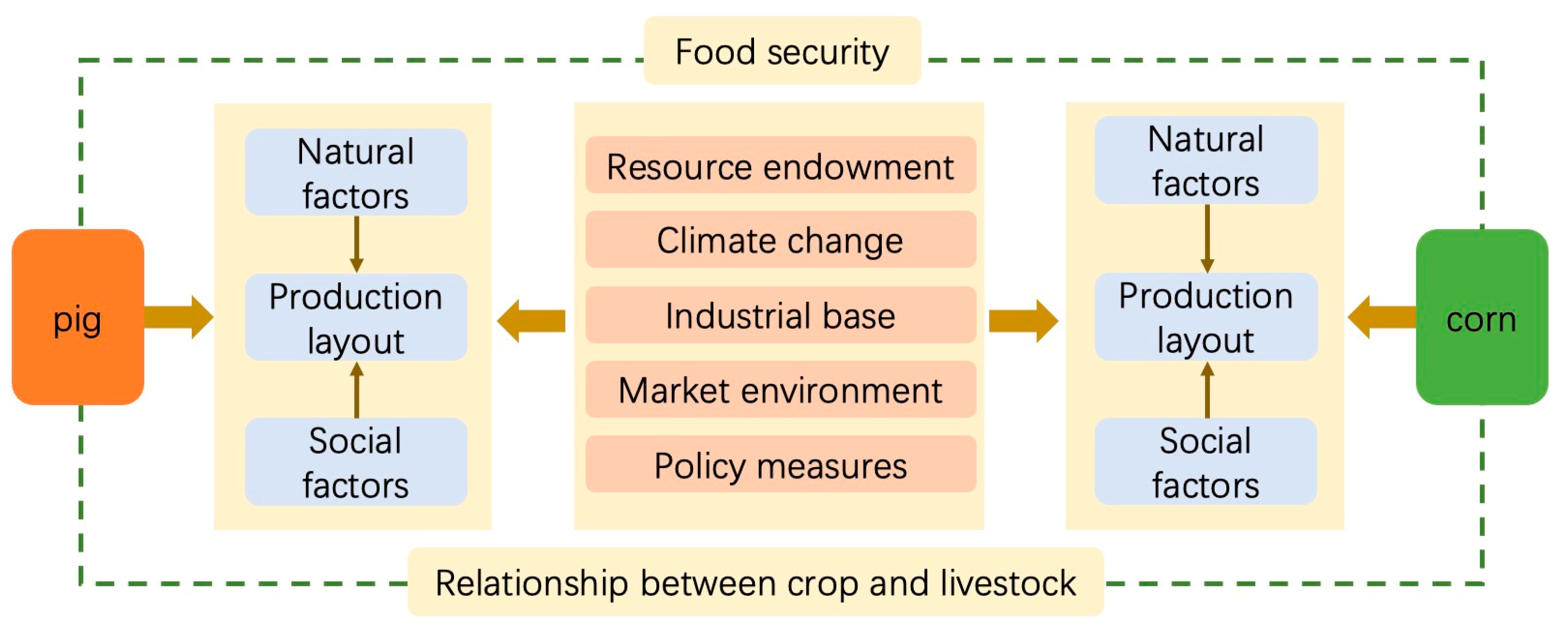
2. Analysis Framework

Spatial zoning and resource environment carrying capacity are crucial for agricultural sustainability [27,28,29]. Contemporary agriculture has evolved from traditional animal-powered farming, through mechanized modern agriculture, towards ecologically driven green agriculture. Optimizing the spatial configuration of agricultural sectors, particularly corn and pig production—China’s largest crop and livestock industries—is essential to enhancing resource efficiency [30,31]. Corn is a key feed grain for pig farming, yet production centers of these two industries are geographically distinct, with pigs concentrated in southern China and corn in the north. To mitigate this spatial imbalance, the government has implemented policies such as promoting pig production in northern regions. However, the drivers behind these imbalances and the effectiveness of such policies remain unclear.
Existing studies show significant geographic agglomeration in pig production, influenced primarily by geographical conditions, urbanization, technology, and environmental regulations [32,33,34]. Intensified pig farming, while enhancing efficiency, exacerbates environmental challenges, particularly manure management [35,36]. Corn production demonstrates a significant positive spatial correlation, shifting gradually northward, with agriculture technology, livestock sector development, infrastructure, and policies identified as influential factors [37,38]. Yet, previous research has examined these industries independently, neglecting the reasons behind their spatial misalignment, hindering integrated crop–livestock ecological development.
Therefore, this study investigates the spatial differentiation and coupling relationships between pig and corn production using centroid analysis, coupling indices, and spatial econometric models. Employing panel data from 31 Chinese provinces (1997–2022), we identify two key imbalance patterns (“more grain, fewer pigs” and “more pigs, fewer grains”) and empirically examine five critical determinants: resource endowment, climate change, industrial foundation, market environment, and policy measures, elucidating the mechanisms driving the spatiotemporal coupling between corn and pig production (Figure 1).

3. Materials and Methods

3.1. Methodology

3.1.1. Center of Gravity Analysis Model

The concept of spatial center of gravity was initially applied in studies on the spatial distribution patterns of population, economy, and industries, and serves as an important indicator reflecting the spatial distribution of geographical entities and phenomena. To clearly illustrate the spatial displacement patterns of corn cultivation and pig farming in China, this study uses the center of gravity analysis model to calculate the production centers of corn and pigs, as well as their interannual displacement distances.
X t = i = 1 n P i t X i / i = 1 n P i t
Y t = i = 1 n P i t Y i / i = 1 n P i t
Specifically, X t and Y t represent the longitude and latitude values of the production center for corn (or pigs) in year t , respectively. X i and Y i represent the longitude and latitude values of the capital city of province i , and P i t represents the corn production or pig slaughter quantity in province i in year t . After calculating the production centers of corn (or pigs) using the ArcGIS 10.8 software platform, the displacement distance of the production center is calculated, with the formula as follows:
D = Z × X w X m 2 + Y w Y m 2
Here, D represents the displacement distance between the production centers of corn (or pigs) across different years. Z is a constant value used to convert geographic coordinates into planar distances, with a value of 111.11 km. X w and X m represent the longitude values of the production centers for corn (or pigs) in years w and m , respectively, while Y w and Y m represent the latitude values of the production centers for corn (or pigs) in years w and m , respectively.

3.1.2. Coupling Development Relationship Index

Traditional studies often use the coupling coordination degree model to measure the coordination relationship between different systems. However, this method still faces considerable debate in terms of weight definition and economic significance. This study aims to explore the spatial distribution patterns between the corn planting and pig farming industries, identifying the evolution trend of their spatial coupling relationship. Therefore, based on the industrial concentration index, the “corn–pig” coupling development relationship index is calculated. The basic principle is that the closer the production concentration index of corn and pigs in the same region, the more coordinated the coupling development relationship between the two industries in that region.
M Q i t = M P i t / i = 1 n M P i t
K Q i t = K P i t / i = 1 n K P i t
ω = 1 M Q i t K Q i t
Here, M P i t and K P i t represent the corn yield and pig slaughter volume, respectively; M Q i t and K Q i t represent the corn production concentration index and pig production concentration index, respectively, which indicate the proportion of corn yield and pig slaughter volume in the national total. ω represents the “corn–pig” coupling development relationship index, with a value range of [0, 1]. A higher ω value indicates a more coordinated relationship between the corn and pig production layouts. To further classify the coupling relationship of “corn–pig” production layouts in different regions and clarify the balance between corn yield and pig slaughter volume in each region, this study further calculates the “corn–pig” production balance coefficient.
φ = K Q i t / M Q i t
Here, φ represents the “corn–pig” production balance coefficient, which is also used to measure the coupling development relationship between corn and pig production layouts. When φ equals 1, it indicates that the corn and pig production concentration indices in that region are the same, meaning the spatial relationship between corn and pig production is highly coordinated. When φ is less than 1, it indicates that corn holds a production advantage over pigs in that region, meaning the proportion of corn yield in the national total is higher than the proportion of pig production, reflecting a “grain-heavy, pig-weak” imbalance. When φ is greater than 1, it indicates that pigs hold a production advantage over corn in that region, meaning the proportion of pig production in the national total is higher than the proportion of corn yield, reflecting a “pig-heavy, grain-weak” imbalance.

3.1.3. Spatial Econometric Analysis Model

This paper uses a spatial econometric model to explore the spatial evolution mechanism of pig and corn production layouts. In terms of the selection of dependent variables, this paper first considers using the coupling development relationship index as the dependent variable. However, the relevant factors mainly affect the coupling development relationship index indirectly by influencing the layout of corn and pig production, and the same factors may have different impacts on the layout of pigs and corn. Therefore, this paper uses the number of pigs slaughtered and corn yield as dependent variables, respectively, analyzing the impact of relevant factors on the production layout of pigs and corn. By comparing the influencing factors, it illustrates the driving mechanism of the coupling relationship. Regarding the selection of influencing factors, this paper first classifies the factors that may affect pig and corn production layouts into two categories: natural factors and social factors. Natural factors mainly include resource endowments and climate change, while social factors encompass industrial foundation, market environment, and policy measures (Table 1). Existing research has proposed three spatial econometric models [39]: the Spatial Lag Model (SLR), Spatial Error Model (SEM), and Spatial Durbin Model (SDM). Among them, the SAM focuses on analyzing the spatial correlation of the explained variables, the SEM focuses on examining the spatial effects of unobservable factors or omitted variables, and both the SAM and SEM are special forms of the SDM. This paper uses the LR test and Wald test to determine the relationships between SDM, SLM, and SEM, and selects the construction of the SDM as follows:
y i t = α + ρ W i j y i t + β X i t + θ W i j X i t + λ i + μ t + ε i t
In the equation, i denotes the province, t denotes the year, y represents the number of pigs slaughtered or the corn yield, W i j is the spatial weight matrix, X i t represents the series of influencing factors for the number of pigs slaughtered or corn yield, λ i and μ t represent individual fixed effects and time fixed effects, respectively, and ε i , t represents the random disturbance term.

3.2. Data Sources and Study Area

Given the availability of data, the study area comprised the 31 provincial-level administrative regions of China, excluding Hong Kong, Macau, and Taiwan. Since Chongqing became a municipality directly under the central government in 1997, and to maintain the integrity of the 31 provincial-level regions of mainland China, the study period selected in this paper is from 1997 to 2022 (the national total corn yield and total number of pigs slaughtered data are updated to 2023). Meanwhile, due to data availability constraints, the panel data research period on the driving mechanisms of production layout is from 2005 to 2022. The data in this paper are sourced from the “China Rural Statistical Yearbook”, the National Bureau of Statistics website (http://www.stats.gov.cn/, accessed on 25 January 2025), and the EPS database. To ensure the comparability of the data, GDP data are benchmarked to 2005 and deflated using the GDP conversion index. In addition, in order to analyze the regional differences, we divided the study area into seven regions: North China (Beijing, Tianjin, Hebei, Shanxi, and Inner Mongolia), Northeast China (Liaoning, Jilin, and Heilongjiang), East China (Shanghai, Jiangsu, Zhejiang, Anhui, Fujian, Jiangxi, and Shandong), Central China (Henan, Hubei, and Hunan), South China (Guangdong, Guangxi, and Hainan), Southwest China (Sichuan, Chongqing, Guizhou, Yunnan, and Tibet), and Northwest China (Shaanxi, Ningxia, Gansu, Qinghai, and Xinjiang). The distribution of study area is shown in Figure 2.

4. Results

4.1. The Spatiotemporal Pattern Evolution of Corn Planting and Pig Farming

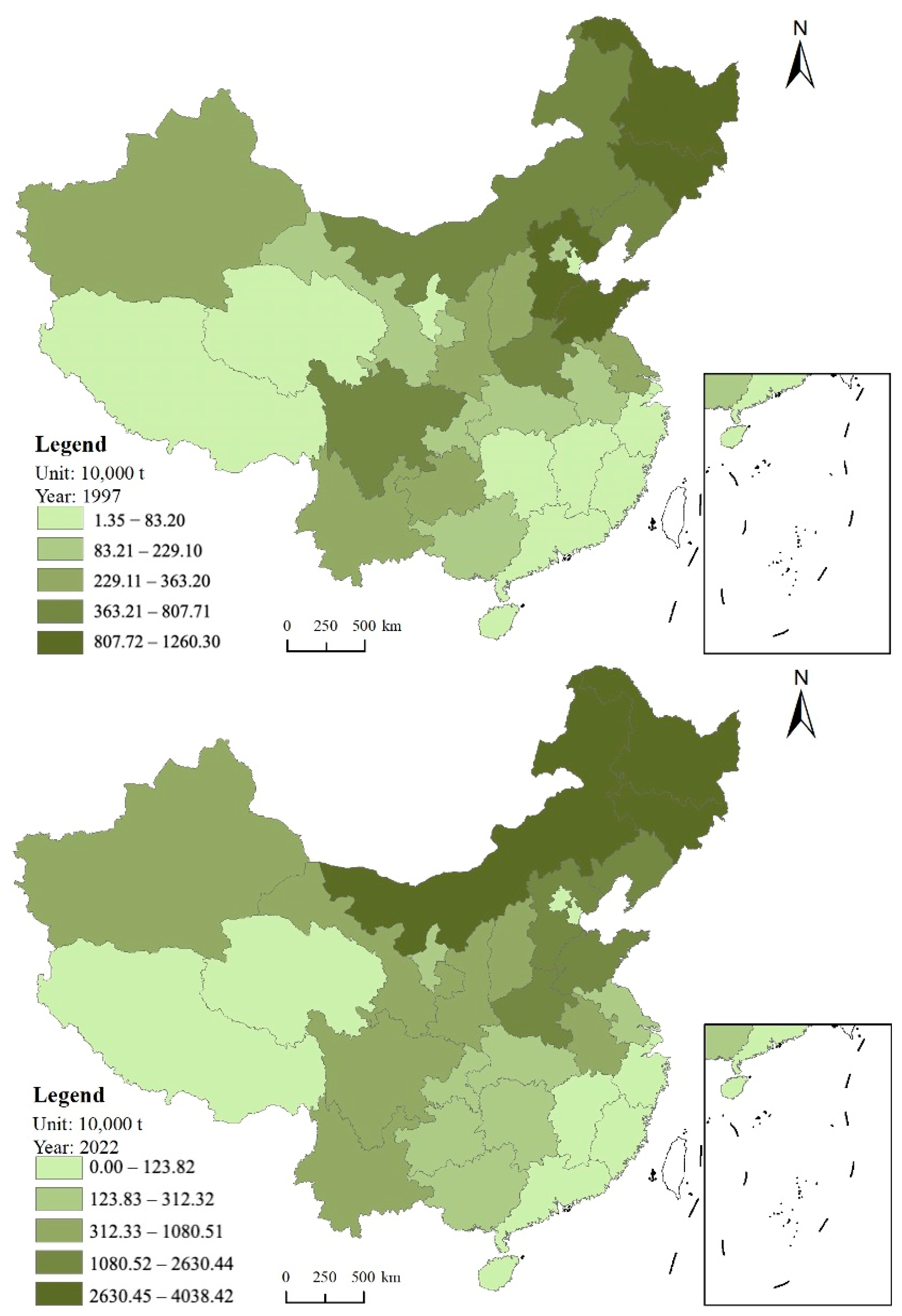
4.1.1. Spatiotemporal Evolution Characteristics of Corn Production Layout

From the temporal trend (Figure 3), corn production increased from 104.3 million tons in 1997 to 288.8 million tons in 2023, with its share of total grain production rising from 21.11% to 41.54%, indicating a significant elevation in the role of corn in food production. The calculations show that from 1997 to 2023, 91.70% of the increase in grain production came from corn, highlighting its critical role in ensuring food security. Corn is not only an important food crop but also a major source of industrial and feed grains. The growth of industrial and feed grains driven by industrialization and changes in dietary structure has been the primary factor driving the expansion of corn production. From the spatial pattern (Figure 4), the region from Heilongjiang to Yunnan is the main area for corn production. Among these, the Northeast region and the three provinces of Hebei, Shandong, and Henan have significant advantages in corn yield. In 1997, the top five provinces in corn production were Jilin, Heilongjiang, Shandong, Hebei, and Henan. The corn production in these five provinces accounted for 51.28% of the national total. In 2022, the top five provinces in corn production changed to Heilongjiang, Jilin, Inner Mongolia, Shandong, and Henan. The corn production in these five regions increased to 55.19% of the national total, indicating a significant rise in the concentration of corn production. Calculations of the production center of corn yield show that it is located within Hebei Province. Since 2000, there has been a clear trend of movement toward the Northeast region, and after 2015, it has stabilized near the border of Hebei Province and Beijing (Figure 5). Overall, the corn production in China presents a “northern-heavy, southern-light” pattern. Over the past 25 years, the northern regions have contributed about 88.06% of the increase in corn production, further highlighting the “northern-heavy, southern-light” layout feature.

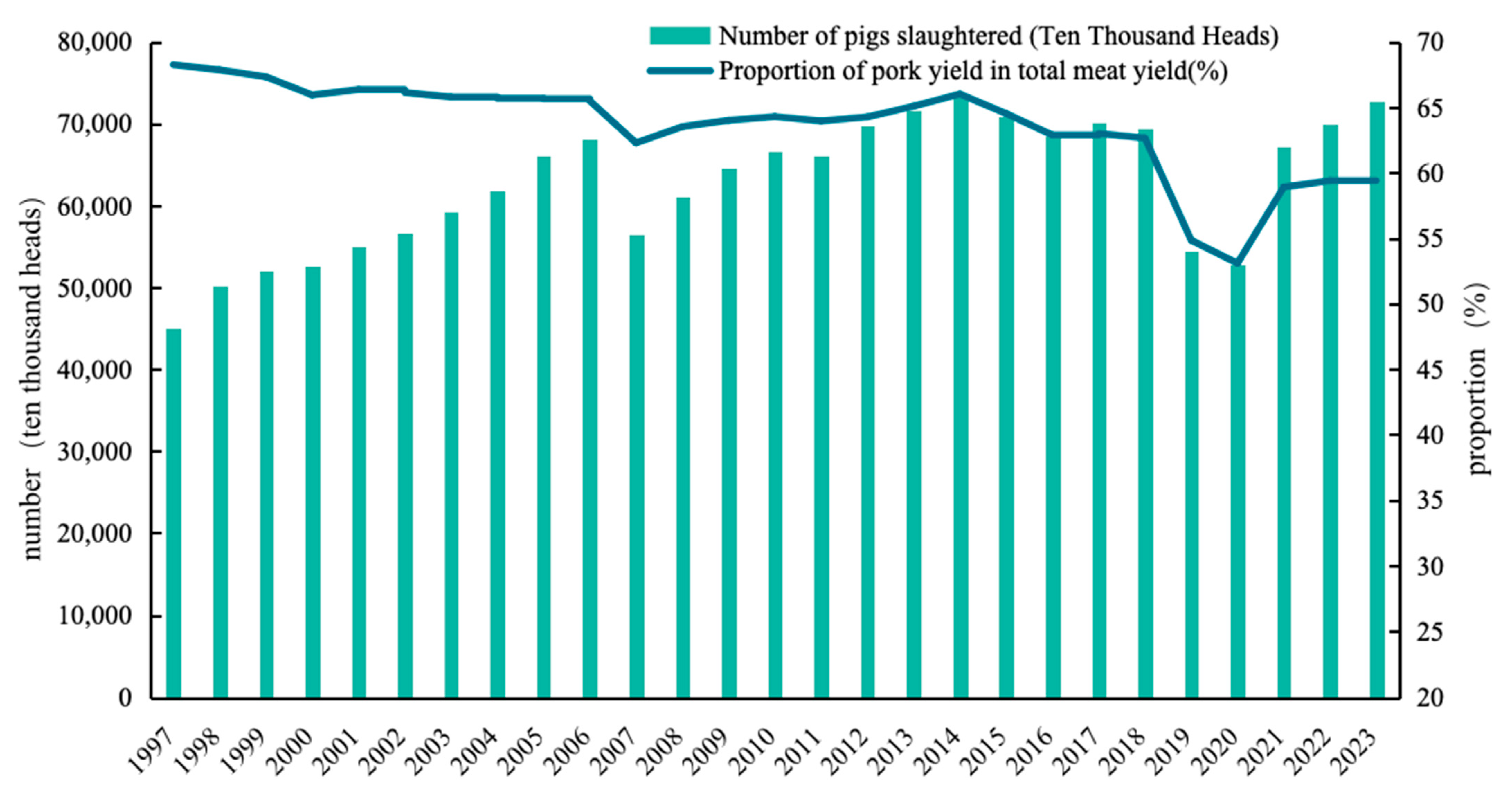
4.1.2. Spatiotemporal Evolution Characteristics of Pig Production Layout

From the temporal trend (Figure 6), the number of pigs slaughtered increased from 450.77 million in 1997 to 726.62 million in 2023, while pork production rose from 52.69 million tons to 97.48 million tons during the same period. The share of pork in total meat production declined from 68.26% to 59.44%. Analysis showed that the growth in pork consumption driven by economic development and improved living standards is the primary reason for the expansion of pig farming. However, the diversification of meat consumption structure due to dietary changes, particularly the increased share of beef and mutton consumption, is an important factor leading to the decline in the share of pork consumption. Notably, from 1997 to 2023, 49.07% of the growth in meat production came from increased pork production, and the share of pork in meat consumption stabilized. Pork remains the largest food source ensuring animal protein supply for Chinese residents. From the spatial pattern (Figure 7), the Huang-Huai-Hai region, Sichuan Basin, and the middle and lower reaches of the Yangtze River are the core regions for pig farming. The pig slaughter volume of the five provinces of Sichuan, Hunan, Henan, Yunnan, and Shandong accounts for about 39.68% of the national total. In 2022, among the 10 provinces with pig slaughter volume exceeding 30 million, only Shandong, Henan, and Hebei are located in the northern region, while the other provinces are concentrated along the middle and lower reaches of the Yangtze River and in the South China region. From 1997 to 2022, the provinces with more than a double increase in pig slaughter volume were Yunnan, Liaoning, Jilin, Heilongjiang, Shanxi, and Xinjiang, mostly concentrated in the northern regions. The increase in Sichuan and Hunan, the two major pig farming provinces, was only 28.64% and 30.37%, respectively, which is relatively low nationwide, indicating that policies such as “Southern pigs, Northern farming” and “Pig reduction in southern water net areas” have effectively slowed the growth trend of pig farming in the south. As seen in Figure 4, the center of pig farming has slightly shifted toward the northwest in Hubei, but the overall change is not significant. This further confirms the accelerated development of pig farming in the northern regions, but the overall layout of pig production still follows the “southern-heavy, northern-light” pattern.

4.2. Analysis of the Coupling Relationship Between Corn Planting and Pig Farming

4.2.1. “Corn–Pig” Coupling Development Relationship Index

From Figure 8a, it can be observed that the overall “corn–pig” coupling development relationship index in the country shows a fluctuating downward trend, indicating that the spatial coupling degree between corn and pig farming is decreasing. Specifically, from 1997 to 2006, the “corn–pig” coupling development relationship index fluctuated around 0.971. From 2007 to 2016, it dropped to a low point, particularly bottoming out in 2011 and 2013, with a minimum value of 0.968. Afterward, it rebounded and stabilized around 0.970. The “corn–pig” coupling development relationship index reflects the difference in the concentration coefficient of production across regions. However, because the share of production in each province is relatively small, the inter-provincial differences in the coupling development relationship index are also small. This study compares the coupling development of corn and pig farming across China’s seven geographical regions. Figure 8b shows that the Northwest region has the highest coupling index, consistently above 0.95, while the Northeast region has the lowest, stabilizing around 0.75. The other regions—North, East, Central, South, and Southwest China—show similar coupling levels, ranging from 0.85 to 0.90. Spatially, corn and pig farming is well balanced in the Northwest, but imbalanced in the Northeast. Over time, coupling coefficients have remained stable, particularly post-2010 when the rate of change slowed. Figure 9 highlights provincial differences, showing a significant decline in the coupling index in South China and the Yunnan–Guizhou Plateau. In 2022, the most pronounced imbalances were found in Heilongjiang, Inner Mongolia, Jilin, and Hunan. Heilongjiang, with 14.57% of national corn production and 3.31% of pig production, has the largest “corn–pig” imbalance. Hunan, where pig production exceeds corn by a factor of 11.02, exemplifies the “more pigs, less grain” imbalance. These regional differences underscore the varied spatial patterns of corn and pig production across China.

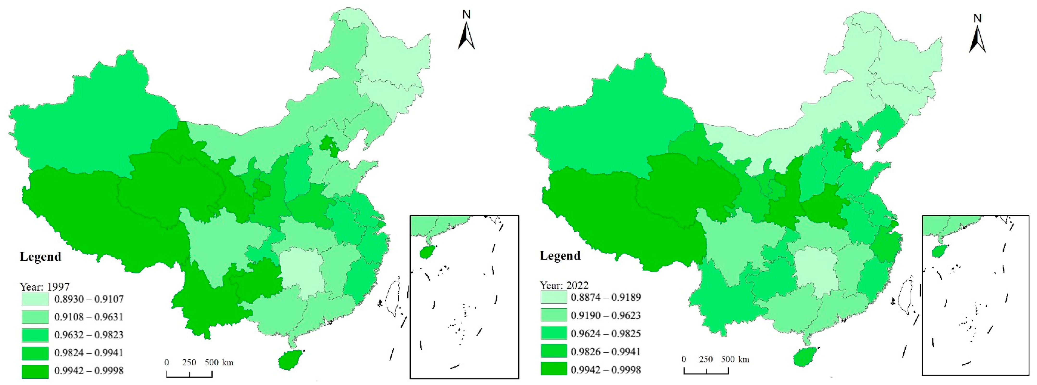
4.2.2. “Corn–Pig” Production Balance Coefficient

The “corn–pig” coupling development relationship index reflects the spatial interaction between corn and pig farming but does not capture the internal carrying capacity of corn for pig farming within regions. To better distinguish regional imbalances in the configuration of corn and pig farming, this study introduces the “corn–pig” production balance coefficient, categorizing regions into two types: “more grain, fewer pigs” and “more pigs, less grain”. A coefficient less than 1 indicates that corn production outweighs pig production, while a coefficient greater than 1 suggests the opposite. Figure 10 reveals that the northern and southern regions exemplify these two patterns. In 1997, only Guizhou in the southern region exhibited a “more grain, fewer pigs” configuration, but by 2022, it shifted to a “more pigs, less grain” configuration. As illustrated in Figure 4, corn production is concentrated in northern China, while pig farming is centered in the south. This spatial distribution underpins the persistent pattern of “more grain in the north, more pigs in the south”. In Southeast China, the “corn–pig” balance coefficient generally exceeds 5, with Jiangxi, Fujian, Guangdong, and Hainan surpassing 15, indicating that pig farming in these regions exceeds the carrying capacity of corn resources. Conversely, in Northeast and North China, the coefficient is typically below 0.7, even dipping below 0.4, highlighting a significant disparity where corn production far exceeds pig farming. For instance, in 2022, Inner Mongolia produced 30.98 million tons of corn (11.18% of the national total) but only 8.87 million pigs (1.27% of the total), with the pig farming share representing just 11.34% of corn’s share. In conclusion, despite the establishment of “restricted breeding zones” and incentives for farming enterprises to relocate to the north, especially to the Northeast, the north–south spatial divide in corn and pig farming (“more corn in the north, more pigs in the south”) remains largely unchanged. The corn production advantage in the north has not been fully integrated with the scale of pig farming, and southern regions continue to face significant environmental pressures regarding water resource management.

4.3. Analysis of the Driving Mechanism of the Coupling Relationship Between Corn Planting and Pig Farming

4.3.1. Spatial Autocorrelation Test and Spatial Model Identification

Spatial correlation is the premise of spatial econometric analysis. Therefore, this study first uses the Moran’s I index to test the spatial correlation of corn yield and pig slaughter volume, to determine whether spatial effects exist. Table 2 shows that, under the spatial adjacency matrix, the Moran’s I index of both corn and pigs is greater than 0, and all years except for 2005 and 2006 passed the significance test. This indicates that the production layouts of corn and pigs both have significant spatial correlation characteristics. Among them, the Moran’s I index for corn is significantly higher than that for pigs and shows an increasing trend, indicating that corn has stronger spatial correlation characteristics relative to pigs, and this spatial correlation has further increased over time. By observing the Moran’s I index for pigs, it can be seen that the spatial correlation of pig production has shifted from being unclear to becoming significantly pronounced, and the increase in the Moran’s I index for pigs suggests that the geographical agglomeration of China’s pig industry has become more apparent. In model selection, the following steps were taken: First, the Hausman test statistic is significant at the 1% level, indicating that a fixed-effects model should be chosen for the empirical model. Second, both the Wald test and the LR test are significant at the 1% level, suggesting that the Spatial Durbin Model (SDM) is more suitable for identifying the main factors affecting pig and corn production layouts. Finally, the spatial autoregressive coefficient (rho) in the Spatial Durbin Model (SDM) is significant at the 1% level and positive, further confirming the presence of significant spatial agglomeration effects for both pig and corn production, and that spillover effects exist between provinces. This also validates the appropriateness of the spatial econometric model chosen in this study.

4.3.2. Analysis of the Factors Affecting Pig Farming Layout

This study employs four models—SDM, SAR, SEM, and OLS—to estimate the factors influencing pig farming layout, with the coefficient estimates presented in Table 3. In the SDM, the spatial lag coefficient (rho) is 0.475, which is significant at the 1% level, indicating that pig production across China’s provinces exhibits significant spatial spillover effects, with a distinct clustering pattern. Notably, the effects of explanatory variable changes vary across regions, which means the SDM cannot directly reflect the impact of these variables on the dependent variable. Instead, the direct, indirect, and total effects of each variable are considered. Table 4 shows that key factors influencing pig farming layout include corn yield, arable land resource allocation, technical level, and comparative advantage. In terms of resource endowment, the direct, indirect, and total effects of corn yield are all significantly negative, suggesting that higher corn yields in a region and its neighboring areas are associated with smaller pig farming scales. This finding contrasts with conventional wisdom and highlights the marked spatial differentiation between corn and pig farming. In the North, where corn is a major crop, pig farming is relatively limited, while in the South, a key pig farming region, the proportion of corn farming is much smaller. This spatial differentiation indicates that corn and pig farming cannot expand simultaneously, reinforcing the low spatial correlation between the two sectors. The effects of arable land resource allocation are all significantly positive, indicating that more abundant arable land in a region and its neighbors leads to a larger scale of pig farming. Arable land not only provides space for growing diverse feed crops but also supports the establishment of pigpens and the management of waste, making it a critical factor in pig farming layout. Regarding the industrial base, both the direct effects of technical level and comparative advantage are significantly positive, suggesting that technological advancement and regional comparative advantages contribute to the expansion of pig farming. The indirect effect of technical level is also positive, indicating that technological spillovers from neighboring areas benefit local pig farming. However, the indirect effect of comparative advantage is negative, likely due to market competition within the pig farming sector, where traditional advantages in one region may limit growth in neighboring areas. Overall, the industrial base is a key factor influencing pig farming layout, with the technical level and comparative advantage having both positive and negative effects on surrounding regions.

4.3.3. Analysis of the Factors Affecting Corn Production Layout

Table 5 presents the parameter estimation results for the factors affecting corn production layout using the SDM, SAR, SEM, and OLS models. It can be observed that in the SDM, the spatial lag coefficient rho is 0.402, which passes the 1% significance level test, indicating that corn production across China’s provinces has significant spatial spillover effects and exhibits a clustering trend in its spatial layout. Table 6 shows that most factors have varying degrees and directions of impact on the corn production layout. In terms of resource endowment, the direct, indirect, and total effects of arable land resource allocation are all significantly positive, indicating that the more abundant the arable land resources in a region and its neighboring areas, the larger the corn production scale in that region. This study argues that arable land is the primary resource supporting corn planting, and abundant arable land resources provide important support for corn cultivation. In terms of industrial base, the three effects of technical level and comparative advantage are all significantly positive, indicating that advanced technology and comparative advantage in a region and its neighboring areas can promote local corn industry development. In terms of market environment, the indirect and total effects of economic development level and population density are both significantly negative, indicating that regions with higher economic development levels and population densities tend to suppress corn production in surrounding areas. The direct effect of livestock farming development on corn production is significantly positive, indicating that livestock farming development in a region stimulates corn production. It is noteworthy that although the spatial correlation between pig farming and corn production is weak, there is a clear association between corn and livestock farming. This suggests that the development of the corn industry can promote the growth of the livestock industry, especially for certain pig substitutes. In terms of policy measures, environmental regulation policies promote the local and surrounding corn industry, indicating that strengthening environmental regulations can provide a more favorable policy environment for corn and other crop industries. At the same time, China is currently advancing carbon neutrality and other ecological civilization initiatives, which will further highlight the ecological value of agriculture, especially crop cultivation.

4.3.4. Comparative Analysis of the Factors Affecting the Layouts of Pig and Corn Production

The analysis of factors influencing the spatial layout of corn and pig production reveals two key findings. First, corn production exerts a significant inhibitory effect on pig farming, supporting the study’s conclusion of spatial misalignment between the two industries. This suggests that corn production is not the primary determinant of pig farming layout, and expanding corn production does not directly stimulate the growth of pig farming. Second, while there are commonalities in the factors affecting both industries, key differences drive the imbalance in their layouts. Notably, arable land resource allocation, technological advancement, and comparative advantage positively impact pig farming layout. These factors underscore the importance of feed crop production, with alternatives to corn also supporting pig farming. Technology and comparative advantage serve as industrial foundations, significantly influencing the layout of pig farming. Despite the government’s “South Pigs, North Farming” policy, the south’s established pig farming foundation remains more attractive than the north’s. While climate factors such as temperature and precipitation were not significant in this study, research from regions like Shandong, Shanxi, Jilin, and Inner Mongolia shows that northern pig farms, particularly in the Northeast, are reluctant to relocate due to cold climates and water scarcity. Based on empirical analysis and field research, the primary factors restricting coordinated corn and pig production development can be summarized as follows: First, corn production is not decisive in pig farming layout; the availability of alternative feeds weakens the dependency between the two industries. Second, the industrial base significantly impacts pig farming layout, with advanced technology and comparative advantage fostering more favorable conditions for expansion. The higher efficiency of pig farming in the south provides a technological advantage. Third, climate factors, particularly temperature and precipitation, play a crucial role in pig farming layout. The south’s favorable heat and water resources offer climatic advantages, while the north’s dry conditions make large-scale pig farming challenging. Overall, the north’s abundance of arable land and strong corn foundation, combined with specific natural and historical factors, explains its dominance in corn production. In contrast, the south’s pig farming industry is supported by a clear industrial foundation and favorable climatic conditions, resulting in the geographical separation of the two industries.

5. Discussion

5.1. Research Contributions

Growing resource and environmental constraints have stimulated extensive discussions regarding agricultural production patterns. Optimizing agricultural spatial configurations to align more closely with resource availability and environmental conditions has emerged as a critical research frontier [23,40,41]. The spatial distributions of corn and pig production identified in this study align closely with previous findings [34,38,42]; however, significant differences emerge concerning factors influencing pig production placement. Previous studies emphasize resource endowments, particularly corn availability, as primary determinants of pig production locations [32]. However, this assertion conflicts with observed spatial patterns. This research identifies a distinct spatial mismatch between corn and pig industries, characterized by a negative correlation, as empirically confirmed by analysis of pig production determinants.
The primary contributions of this research are twofold. First, it extends existing theories on agricultural spatial relationships by introducing a coupling development relationship index, which serves as an effective methodological framework for assessing coordination across agricultural sectors, thereby addressing theoretical gaps in earlier research. Second, the study employs a spatial econometric model to empirically analyze determinants affecting corn and pig production layouts. A comparative analysis elucidates the critical factors underpinning their spatial mismatch. Consequently, this study clearly defines the spatial relationship between China’s corn and pig industries and identifies significant factors influencing their spatiotemporal coupling. These insights provide foundational guidance for fostering integrated crop–livestock systems and promoting sustainable, circular agricultural practices.

5.2. Policy Recommendations

Based on the study’s findings, several policy recommendations are proposed. Firstly, it is essential to accelerate technological innovation and dissemination within pig farming and other livestock sectors to improve production efficiency. Initiatives should include targeted professional training programs and inter-regional exchanges aimed at reducing technological disparities. Secondly, enhancing the efficient utilization of agricultural waste and crop residues through biotechnological innovations is recommended, converting agricultural by-products into renewable energy and protein sources beneficial for livestock industries. Thirdly, aligning resource environment carrying capacities with market demand is crucial for rationalizing the spatial layouts of corn and pig production. This approach advocates moderate expansion of pig farming in northern regions, adhering strictly to ecological and environmental constraints.

5.3. Limitations

In conclusion, this study clearly elucidates the spatial relationship between corn and pig industries and identifies the primary drivers of their spatial mismatch, thus significantly contributing to integrated crop–livestock collaboration and sustainable agricultural development. This research advances beyond prior intra-industry analyses by offering novel perspectives on spatial interactions between crop cultivation and animal husbandry. Nonetheless, several limitations persist, warranting further exploration. Firstly, although the analysis addresses multiple dimensions influencing corn and pig production distributions, numerous complex ecological and socio-economic factors remain challenging to fully incorporate. Secondly, the study did not directly evaluate coupling coordination between corn and pig production as an explicit dependent variable. Instead, separate comparative analyses on corn and pig production scales were performed, highlighting differential impacts of similar factors on each industry but providing insufficient clarity on underlying coupling mechanisms. Lastly, this research did not simulate environmental and economic outcomes resulting from adjusted production layouts. Future investigations should incorporate simulations to evaluate the resource environmental benefits and economic impacts associated with optimizing corn and pig production arrangements.

6. Conclusions

This study examines the spatial relationship between corn and pig farming in China, introducing the “corn–pig” coupling development relationship index and a coupling analysis framework to identify the driving mechanisms behind their spatiotemporal evolution. Key findings include the following: (1) Corn and pigs are central to China’s crop farming and animal husbandry sectors. While the corn production center continues to shift northward, the pig production center in the south remains stable. (2) The national “corn–pig” coupling development index has declined, with regional disparities; the Northeast shows the weakest coupling. (3) The “corn–pig” production balance coefficient reveals a clear north–south division, with the north focused on “more grain, fewer pigs” and the south on “more pigs, less grain”. This division has persisted. (4) Key factors driving this separation include the availability of alternative feed grains, industrial infrastructure, and climate conditions, which have stabilized the geographic distribution of corn and pig farming. These findings contribute to our understanding of the spatiotemporal dynamics of China’s agricultural sectors and offer insights for optimizing agricultural production and promoting sustainable development.

Author Contributions

X.X.: investigation, methodology, conceptualization, writing—original draft, writing—review and editing; H.L.: writing—review and editing; L.F.: formal analysis, writing—review and editing, data curation. All authors have read and agreed to the published version of the manuscript.

Funding

This research was funded by 2024 Open Fund of the South China Tropical and Subtropical Natural Resources Monitoring Key Laboratory, Ministry of Natural Resources (Grant No. 2024NRMK04), and the National Natural Science Foundation of China (Grant No. 72033009).

Data Availability Statement

The original contributions presented in this study are included in the article. Further inquiries can be directed to the corresponding authors.

Acknowledgments

This work was supported by relevant farms, enterprises, and cooperatives. We would like to express our gratitude to the staff who provided support and guidance for this study.

Conflicts of Interest

The authors declare no conflicts of interest.

References

  1. Xiong, X.; Wang, M. Research on Estimation and Pathways to Address the Scale of Food Gap in China under the Greater Food Approach. J. Nat. Resour. 2025, 40, 750–766. [Google Scholar] [CrossRef]
  2. Runhaar, H. Governing towards Sustainable Food Systems: New Connections for More Diversity. Int. J. Agric. Sustain. 2025, 23, 2475254. [Google Scholar] [CrossRef]
  3. Duan, D. Study on Sustainable Agricultural Structure Optimization Method Based on Multiobjective Optimization Algorithm. Comput. Intell. Neurosci. 2022, 2022, 5850684. [Google Scholar] [CrossRef] [PubMed]
  4. Yang, D.; Liu, Z. Does Farmer Economic Organization and Agricultural Specialization Improve Rural Income? Evidence from China. Econ. Model. 2012, 29, 990–993. [Google Scholar] [CrossRef]
  5. Wang, R.; Zhang, Y.; Zou, C. How Does Agricultural Specialization Affect Carbon Emissions in China? J. Clean. Prod. 2022, 370, 133463. [Google Scholar] [CrossRef]
  6. Zhang, Z.; Chen, Y.; Mishra, A.K.; Ni, M. Effects of Agricultural Subsidy Policy Adjustment on Carbon Emissions: A Quasi-Natural Experiment in China. J. Clean. Prod. 2025, 487, 144603. [Google Scholar] [CrossRef]
  7. Yue, Q.; Adamowski, J.; Cao, X.; Chen, D.; Xuanyuan, M.; Elbeltagi, A.; Dai, X. Managing Agricultural Crop and Livestock Land Use for Synergistic Energy-Economy-Environment Development: A Hybrid Multi-Objective Optimization Approach under a Waste-to-Energy Nexus. J. Clean. Prod. 2025, 486, 144544. [Google Scholar] [CrossRef]
  8. Shen, Y.; Hu, P.; Hou, Y.; Ying, Z.; Wang, G. Research on the Supervision Mechanism and Effect of Environmental Regulation—Re-Estimation Based on China’s Corn Planting Fertilizer Pollution. Pol. J. Environ. Stud. 2022, 31, 4313–4330. [Google Scholar] [CrossRef]
  9. Dai, W. Bin Research on Prevention and Control of Chinese Agricultural Ecological Environment Pollution to Ensure Food Safety. Adv. Mat. Res. 2012, 616–618, 2247–2250. [Google Scholar] [CrossRef]
  10. Chen, X.; Chen, Y.; Liu, X.; Li, Y.; Wang, X. Investigating Historical Dynamics and Mitigation Scenarios of Anthropogenic Greenhouse Gas Emissions from Pig Production System in China. J. Clean. Prod. 2021, 296, 126572. [Google Scholar] [CrossRef]
  11. Li, C.; Wu, K.; Wu, J. Environmental Hazard in Shanghai, China: Lessons Learned from Huangpu River Dead Pigs Incident. Nat. Hazards 2017, 88, 1269–1272. [Google Scholar] [CrossRef]
  12. Wang, S.; Huang, X.; Zhang, Y.; Yin, C.; Richel, A. The Effect of Corn Straw Return on Corn Production in Northeast China: An Integrated Regional Evaluation with Meta-Analysis and System Dynamics. Resour. Conserv. Recycl. 2021, 167, 105402. [Google Scholar] [CrossRef]
  13. Hu, Y.; Zhang, J.; Liu, Q. Exploring the Path of Balanced Development: The Decoupling Evaluation of Agricultural Production Efficiency and Land Carrying Capacity. Land Degrad. Dev. 2025, 36, 599–613. [Google Scholar] [CrossRef]
  14. Yu, Z.; Su, D.; Wang, S.; Wei, C.; Li, N.; Qu, Y.; Wang, M. Dynamic Matching and Spatial Optimization of Land Use and Resource-Environment Constraints in Typical Regions of the Yellow River Basin in China. Land 2023, 12, 1420. [Google Scholar] [CrossRef]
  15. Zhang, X.; Sun, S.; Yao, S. Spatiotemporal Distribution and Dynamic Evolution of Grain Productivity Efficiency in the Yellow River Basin of China. Environ. Dev. Sustain. 2023, 26, 12005–12030. [Google Scholar] [CrossRef]
  16. Yin, P.; Fang, X.; Tian, Q.; Ma, Y. The Changing Regional Distribution of Grain Production in China in the 21st Century. J. Geogr. Sci. 2006, 16, 396–404. [Google Scholar] [CrossRef]
  17. Jia, S.; Qiu, Y.; Yang, C. Sustainable Development Goals, Financial Inclusion, and Grain Security Efficiency. Agronomy 2021, 11, 2542. [Google Scholar] [CrossRef]
  18. Sun, S.K.; Yin, Y.L.; Wu, P.T.; Wang, Y.B.; Luan, X.B.; Li, C. Geographical Evolution of Agricultural Production in China and Its Effects on Water Stress, Economy, and the Environment: The Virtual Water Perspective. Water Resour. Res. 2019, 55, 4014–4029. [Google Scholar] [CrossRef]
  19. Bole, Y.; Rina, S.; Guga, S.; Na, M.; Fan, S.; Zhang, J. Evaluation of Resources, Environment, and Ecological Carrying Capacity from the Perspective of “Production-Living-Ecology” Spaces: A Case Study of Western Jilin Province, China. J. Clean. Prod. 2025, 491, 144770. [Google Scholar] [CrossRef]
  20. Zhang, Y.; Gao, Y.; Zhang, Y.; Liang, Z.; Zhang, Z.; Zhao, Y.; Li, P. Assessment of Agricultural Water Resources Carrying Capacity and Analysis of Its Spatio-Temporal Variation in Henan Province, China. J. Clean. Prod. 2023, 403, 136869. [Google Scholar] [CrossRef]
  21. Davis, K.F.; Rulli, M.C.; Seveso, A.; D’Odorico, P. Increased Food Production and Reduced Water Use through Optimized Crop Distribution. Nat. Geosci. 2017, 10, 919–924. [Google Scholar] [CrossRef]
  22. Rising, J.; Devineni, N. Crop Switching Reduces Agricultural Losses from Climate Change in the United States by Half under RCP 8.5. Nat. Commun. 2020, 11, 4991. [Google Scholar] [CrossRef] [PubMed]
  23. Xie, W.; Zhu, A.; Ali, T.; Zhang, Z.; Chen, X.; Wu, F.; Huang, J.; Davis, K.F. Crop Switching Can Enhance Environmental Sustainability and Farmer Incomes in China. Nature 2023, 616, 300–305. [Google Scholar] [CrossRef]
  24. Aung, M.M.; Chang, Y.S. Traceability in a Food Supply Chain: Safety and Quality Perspectives. Food Control 2014, 39, 172–184. [Google Scholar] [CrossRef]
  25. Usman, M.; Makhdum, M.S.A. What Abates Ecological Footprint in BRICS-T Region? Exploring the Influence of Renewable Energy, Non-Renewable Energy, Agriculture, Forest Area and Financial Development. Renew Energy 2021, 179, 12–28. [Google Scholar] [CrossRef]
  26. Cai, J.; Li, X.; Liu, L.; Chen, Y.; Wang, X.; Lu, S. Coupling and Coordinated Development of New Urbanization and Agro-Ecological Environment in China. Sci. Total Environ. 2021, 776, 145837. [Google Scholar] [CrossRef]
  27. Zhang, H.; Zhang, J.; Song, J. Analysis of the Threshold Effect of Agricultural Industrial Agglomeration and Industrial Structure Upgrading on Sustainable Agricultural Development in China. J. Clean. Prod. 2022, 341, 130818. [Google Scholar] [CrossRef]
  28. Liu, Y.; Sun, D.; Wang, H.; Wang, X.; Yu, G.; Zhao, X. An Evaluation of China’s Agricultural Green Production: 1978–2017. J. Clean. Prod. 2020, 243, 118483. [Google Scholar] [CrossRef]
  29. Pan, W.-T.; Zhuang, M.-E.; Zhou, Y.-Y.; Yang, J.-J. Research on Sustainable Development and Efficiency of China’s E-Agriculture Based on a Data Envelopment Analysis-Malmquist Model. Technol. Forecast. Soc. Change 2021, 162, 120298. [Google Scholar] [CrossRef]
  30. Chen, P.; Wang, S.; Liu, Y.; Tang, Q.; Wang, Y.; Song, J.; Wu, X.; Zhang, H. Improve Food, Water, and Economic Benefits in China’s Oases through Crop Switching. Int. J. Appl. Earth Obs. Geoinf. 2024, 131, 103946. [Google Scholar] [CrossRef]
  31. Guan, Q.; Tang, J.; Davis, K.F.; Kong, M.; Feng, L.; Shi, K.; Schurgers, G. Improving Future Agricultural Sustainability by Optimizing Crop Distributions in China. PNAS Nexus 2024, 4, pgae562. [Google Scholar] [CrossRef]
  32. Wang, H.; Qiao, J. An Economic Analysis on the Changes in the Distribution of Pig Production in China. Econ. Geogr. 2017, 37, 129–136+215. [Google Scholar]
  33. Yu, Y.; Zhang, H.; Hu, H. Analysis of the Impact of Environmental Regulation on the Distribution of Pig Production in China. Chin. Rural Econ. 2011, 8, 81–88. [Google Scholar]
  34. Zhao, J.; Chen, Y.; Yu, L.; Yin, C. Spatial-Temporal Characteristics and Affecting Factors of Swine Breeding Industry in China. Econ. Geogr. 2019, 39, 180–189. [Google Scholar]
  35. Schulte-Uebbing, L.F.; Beusen, A.H.W.; Bouwman, A.F.; de Vries, W. From Planetary to Regional Boundaries for Agricultural Nitrogen Pollution. Nature 2022, 610, 507–512. [Google Scholar] [CrossRef]
  36. Xin, X.; Wang, Z.; Liu, C.; Wang, J. Development Situations, Problems and Countermeasures of China’s Hog Industry in the New Stage. Issues Agric. Econ. 2023, 8, 4–16. [Google Scholar]
  37. Liu, S.; Liu, S. Analysis of Space-Time Changes and Motivations of Corn Production in China’s Three Plains. World Agric. 2023, 1, 89–98. [Google Scholar]
  38. Chen, H.; Wang, Q.; Zhou, H. Empirical Analysis of Corn Spatial Distribution Variation in China. Econ. Geogr. 2015, 35, 165–171. [Google Scholar]
  39. Elhorst, J.P. Matlab Software for Spatial Panels. Int. Reg. Sci. Rev. 2014, 37, 389–405. [Google Scholar] [CrossRef]
  40. Bowles, T.M.; Mooshammer, M.; Socolar, Y.; Calderón, F.; Cavigelli, M.A.; Culman, S.W.; Deen, W.; Drury, C.F.; Garcia y Garcia, A.; Gaudin, A.C.M.; et al. Long-Term Evidence Shows That Crop-Rotation Diversification Increases Agricultural Resilience to Adverse Growing Conditions in North America. One Earth 2020, 2, 284–293. [Google Scholar] [CrossRef]
  41. Zhou, K.; Li, J.; Wang, Q. Evaluation on Agricultural Production Space and Layout Optimization Based on Resources and Environmental Carrying Capacity: A Case Study of Fujian Province. Geogr. Sci. 2021, 41, 280–289. [Google Scholar]
  42. Zhao, Y.; Bai, Z.; Liu, L.; Fan, X.; Ma, L. Impacts of Subsidy for Export of Pig to Domestic Market on the Spatial Distribution of Pig Production and Related Nitrogen Losses in China. Sci. Total Environ. 2024, 907, 167990. [Google Scholar] [CrossRef] [PubMed]
Figure 1. Analytical framework.
Land 14 00806 g001
Figure 2. Distribution of study area.
Land 14 00806 g002
Figure 3. Trend of corn yield changes. Data source: National Bureau of Statistics of China.
Land 14 00806 g003
Figure 4. Spatial layout of corn production. Data source: National Bureau of Statistics of China.
Land 14 00806 g004
Figure 5. The central focus of corn and pig production. Data source: Calculated based on corn and pig production data from the National Bureau of Statistics of China.
Land 14 00806 g005
Figure 6. Trend of hog slaughter volume. Data source: National Bureau of Statistics of China.
Land 14 00806 g006
Figure 7. Spatial distribution of hog slaughter volume. Data source: National Bureau of Statistics of China.
Land 14 00806 g007
Figure 8. Evolution trend (a) and regional differences (b) in the “corn–pig” coupling development relationship index. Data source: National Bureau of Statistics of China.
Land 14 00806 g008
Figure 9. Spatial distribution of the “corn–pig” coupling development relationship index. Data source: Calculated based on corn and pig production data from the National Bureau of Statistics of China.
Land 14 00806 g009
Figure 10. Spatial distribution of the “corn–pig” production balance coefficient. Data source: Calculated based on corn and pig production data from the National Bureau of Statistics of China.
Land 14 00806 g010
Table 1. Selection of influencing factors for corn and pig production layout.
Variable TypePigCorn
Resource endowmentCorn yieldcorn yield/total national corn productionWater resource availabilitytotal water resources/administrative area
Water resource availabilitytotal water resources/administrative areaArable land allocationeffective irrigated area/population
Arable land allocationeffective irrigated area/population
Climate changeTemperatureaverage annual temperatureTemperatureaverage annual temperature
Precipitationannual precipitationPrecipitationannual precipitation
Industrial baseTechnological levelpig slaughter volume/herd inventoryTechnological levelcorn yield/corn sown area
Comparative advantagelivestock output/agriculture, forestry, animal husbandry, and fishery total outputComparative advantagelivestock output/agriculture, forestry, animal husbandry, and fishery total output
Transportation accessibilitytransportation mileage/administrative areaTransportation accessibilitytransportation mileage/administrative area
Market environmentEconomic development levelGDP/total population at year-endEconomic development levelGDP/total population at year-end
Population densitytotal population at year-end/administrative areaPopulation densitytotal population at year-end/administrative area
Urbanization rateurban population/total population at year-endUrbanization rateurban population/total population at year-end
Livestock developmentlivestock output value
Policy measuresFiscal investmentagricultural, forestry, and water affairs expenditure/agriculture, forestry, animal husbandry, and fishery total outputFiscal investmentagricultural, forestry, and water affairs expenditure/agriculture, forestry, animal husbandry, and fishery total output
Environmental regulationenvironmental regulation coefficientEnvironmental regulationenvironmental regulation coefficient
Data source: The factors listed above were identified by the authors based on theoretical framework analysis, with relevant data obtained from the China Rural Statistical Yearbook, the official website of the National Bureau of Statistics of China, and the EPS database.
Table 2. Spatial autocorrelation test results of corn and pig production layout.
YearPigCornYearPigCorn
Moran’s IZ ValueMoran’s IZ ValueMoran’s IZ ValueMoran’s IZ Value
20050.0770.9350.519 ***4.71420140.154 *1.5890.570 ***5.251
20060.0690.8750.559 ***5.03620150.157 *1.6130.574 ***5.305
20070.130 *1.3900.545 ***4.87920160.159 *1.6220.596 ***5.421
20080.129 *1.3800.559 ***5.01420170.169 **1.7000.589 ***5.338
20090.127 *1.3670.523 ***4.70520180.173 **1.7350.564 ***5.159
20100.130 *1.3950.549 ***4.94420190.166 **1.6730.591 ***5.374
20110.135 *1.4340.576 ***5.19720200.121 *1.3110.583 ***5.254
20120.143 *1.4930.582 ***5.27820210.168 **1.6910.602 ***5.487
20130.152 *1.5660.599 ***5.44920220.173 **1.7370.600 ***5.438
Note: *, **, and *** indicate significance at the 10%, 5%, and 1% levels, respectively.
Table 3. Model results of the factors influencing pig production layout.
VariablesSDMSARSEMOLS
Corn yield−55.879 ** (26.249)−66.765 *** (25.951)−55.379 *** (25.779)−81.559 *** (26.242)
Water resource availability−0.384 (1.389)−0.773 (1.236)−0.134 (1.347)−0.320 (1.259)
Arable land allocation74.563 *** (15.344)64.577 *** (14.151)64.324 *** (14.147)63.690 *** (15.400)
Temperature4.592 (25.402)−11.466 (20.872)−0.561 (24.428)−7.508 (25.851)
Precipitation0.065 (0.077)0.053 (0.076)0.039 (0.076)0.023 (0.078)
Technological level74.304 * (55.273)113.865 ** (49.496)107.457 * (55.538)97.830 * (57.430)
Comparative advantage8.703 ** (3.855)4.806 ** (3.606)10.635 *** (3.807)6.433 * (3.813)
Transportation accessibility−45.712 (67.841)−2.519 (64.471)1.200 (68.160)3.532 (68.833)
Economic development level−0.001(0.005)−0.001(0.004)−0.000 (0.004)−0.005 (0.005)
Population density0.185 (0.289)0.254 (0.265)0.208 (0.274)−0.119 (0.313)
Urbanization rate−7.692 (8.963)−0.422 (4.514)0.892 (5.274)−1.195 (7.865)
Fiscal investment0.515 (0.931)1.057 (0.854)1.528 * (0.864)1.704 * (0.930)
Environmental regulation−0.002 (0.003)−0.004 (0.003)−0.003 (0.003)−0.005 * (0.003)
rho0.475 *** (0.041)0.517 *** (0.041)
lgt_theta−3.362 *** (0.142)−3.340 *** (0.038)
sigma2_e68,901.720 *** (4329.799)72,572.710 *** (4571.753)72,040.270 *** (4553.897)
lambda 0.547 *** (0.039)
Observations558558558558
R-squared0.4950.3020.2370.131
Number of id31313131
Note: *, **, and *** indicate significance at the 10%, 5%, and 1% levels, respectively. The values in parentheses represent the robust standard errors.
Table 4. Effect decomposition of factors influencing pig production layout.
VariablesDirect EffectIndirect EffectTotal Effect
Corn yield−73.232 *** (28.221)−229.410 ** (90.621)−302.642 *** (102.638)
Water resource availability−0.938 (1.310)−6.232 (4.139)−7.170 (4.384)
Arable land allocation85.600 *** (16.008)125.380 ** (58.654)210.979 *** (66.000)
Temperature−1.186 (23.588)−73.781 (55.210)−74.967 (56.509)
Precipitation0.092 (0.076)0.309 (0.216)0.400 (0.250)
Technological level79.121 * (53.183)35.361 * (145.441)114.482 * (156.575)
Comparative advantage4.915 * (4.057)−47.927 *** (11.450)−43.012 *** (12.704)
Transportation accessibility−48.999 (65.669)−18.855 (210.007)−67.854 (228.677)
Economic development level−0.002 (0.005)−0.012 (0.020)−0.014 (0.022)
Population density0.183 (0.288)−0.254 (1.089)−0.172 (1.168)
Urbanization rate−6.137 (8.397)20.979 (20.531)14.842 (20.792)
Fiscal investment0.177 (1.011)−4.478 (2.858)−4.301 (3.383)
Environmental regulation−0.003 (0.003)−0.005 (0.009)−0.008 (0.011)
Note: *, **, and *** indicate significance at the 10%, 5%, and 1% levels, respectively. The values in parentheses represent the robust standard errors.
Table 5. Model results of the factors influencing corn production layout.
VariablesSDMSARSEMOLS
Water resource availability−0.190 (0.552)−0.443 (0.498)−0.289 (0.577)−0.298 (0.595)
Arable land allocation81.076 *** (5.354)79.382 *** (5.194)78.785 *** (5.863)96.861 *** (5.963)
Temperature−1.904 (9.794)11.818 (7.956)1.099 (9.498)22.807 ** (8.840)
Precipitation0.029 (0.031)0.031 (0.031)0.020 (0.033)0.037 (0.037)
Technological level77.101 *** (10.556)74.090 *** (10.871)70.757 *** (11.339)88.625 *** (12.904)
Comparative advantage19.312 *** (2.426)22.259 *** (2.031)26.049 *** (2.603)38.810 *** (1.857)
Transportation accessibility−11.602 (26.823)−24.492 (25.704)−16.043 (29.103)−27.211 (30.710)
Economic development level−0.000 (0.002)−0.001 (0.096)0.000 (0.002)0.000 (0.002)
Population density0.128 (0.095)0.002 (0.096)−0.016 (0.099)−0.049 (0.099)
Urbanization rate−3.374 (3.281)−10.574 *** (1.965)−5.592 ** (2.377)−9.518 *** (2.334)
Livestock development0.270 *** (0.028)0.246 *** (0.026)0.272 *** (0.029)0.260 *** (0.030)
Fiscal investment−0.387 (0.403)−0.441 (0.352)0.346 (0.381)0.411 (0.411)
Environmental regulation0.001 (0.001)0.001 (0.001)−0.000 (0.001)0.001 (0.001)
Rho0.402 *** (0.049)0.449 *** (0.033)
lgt_theta−2.084 *** (0.184)−2.717 *** (0.161)
sigma2_e10,918.540 *** (693.214)11,924.330 *** (746.475)72,040.270 *** (4553.897)
Lambda 0.547 *** (0.039)
Observations558558558558
R-squared0.7340.7300.2370.131
Number of id31313131
Note: ** and *** indicate significance at the 5% and 1% levels, respectively. The values in parentheses represent the robust standard errors.
Table 6. Effect decomposition of factors influencing corn production layout.
VariablesDirect EffectIndirect EffectTotal Effect
Water resource availability−2.000 (0.550)−0.419 (1.397)−0.618 (1.459)
Arable land allocation87.836 *** (5.521)97.039 *** (20.545)184.875 *** (23.101)
Temperature4.258 (8.954)71.649 *** (19.024)75.907 *** (19.331)
Precipitation0.034 (0.032)0.074 (0.075)0.108 (0.088)
Technological level83.653 *** (10.603)88.869 ** (35.813)172.522 *** (40.576)
Comparative advantage21.605 *** (2.241)29.998 *** (4.387)51.603 *** (4.019)
Transportation accessibility−16.071 (27.422)−62.912 (82.222)−78.983 (86.760)
Economic development level−0.002 (0.002)−0.023 *** (0.007)−0.025 *** (0.008)
Population density0.073 (0.094)−0.863 ** (0.394)−0.790 * (0.424)
Urbanization rate−3.120 (3.102)1.174 (7.140)−1.946 (7.104)
Livestock development0.273 *** (0.028)0.032 (0.069)0.305 *** (0.077)
Fiscal investment−0.327 (0.425)0.424 (1.056)0.097 (1.255)
Environmental regulation0.002 * (0.001)0.015 *** (0.003)0.016 *** (0.004)
Note: *, **, and *** indicate significance at the 10%, 5%, and 1% levels, respectively. The values in parentheses represent the robust standard errors.
Disclaimer/Publisher’s Note: The statements, opinions and data contained in all publications are solely those of the individual author(s) and contributor(s) and not of MDPI and/or the editor(s). MDPI and/or the editor(s) disclaim responsibility for any injury to people or property resulting from any ideas, methods, instructions or products referred to in the content.

