
A Historical Review of the Land Subsidence Phenomena Interaction with Flooding, Land Use Changes, and Storms at the East Thessaly Basin—Insights from InSAR Data


Abstract
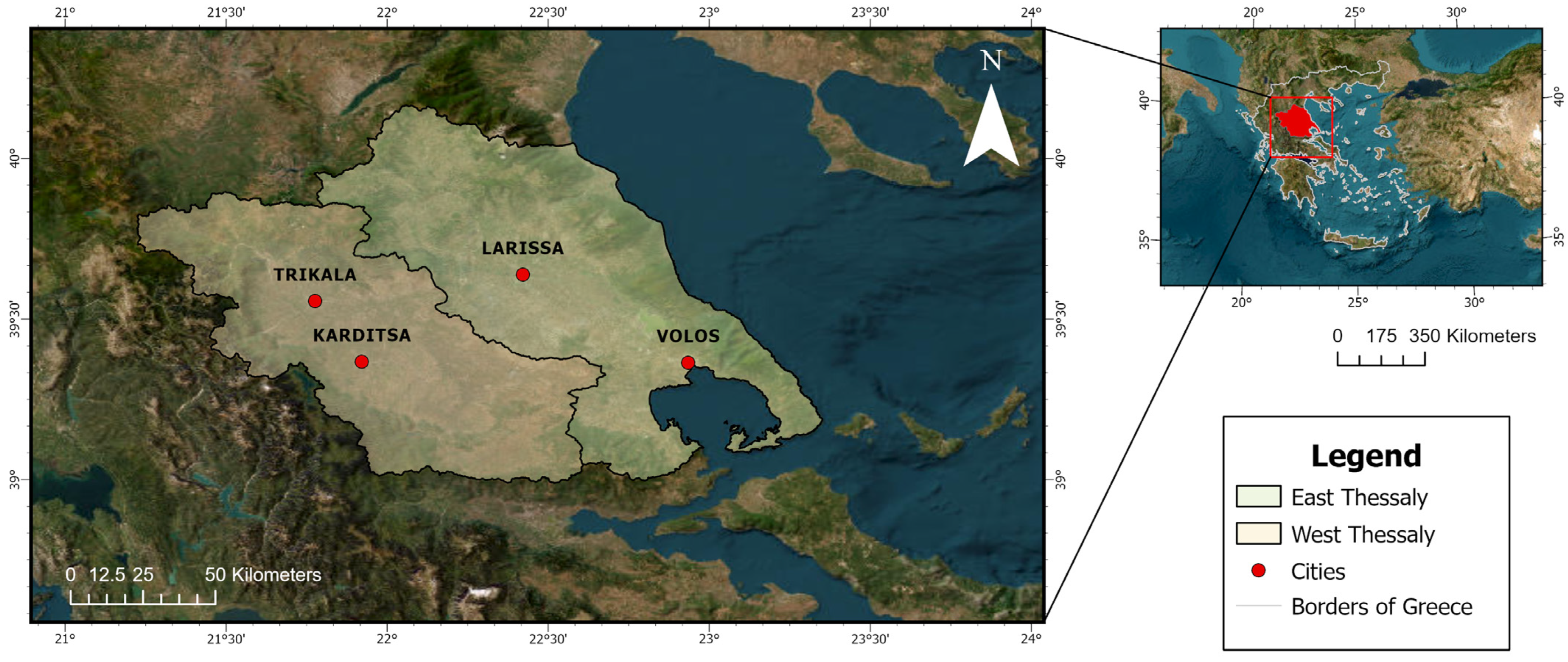
:1. Introduction
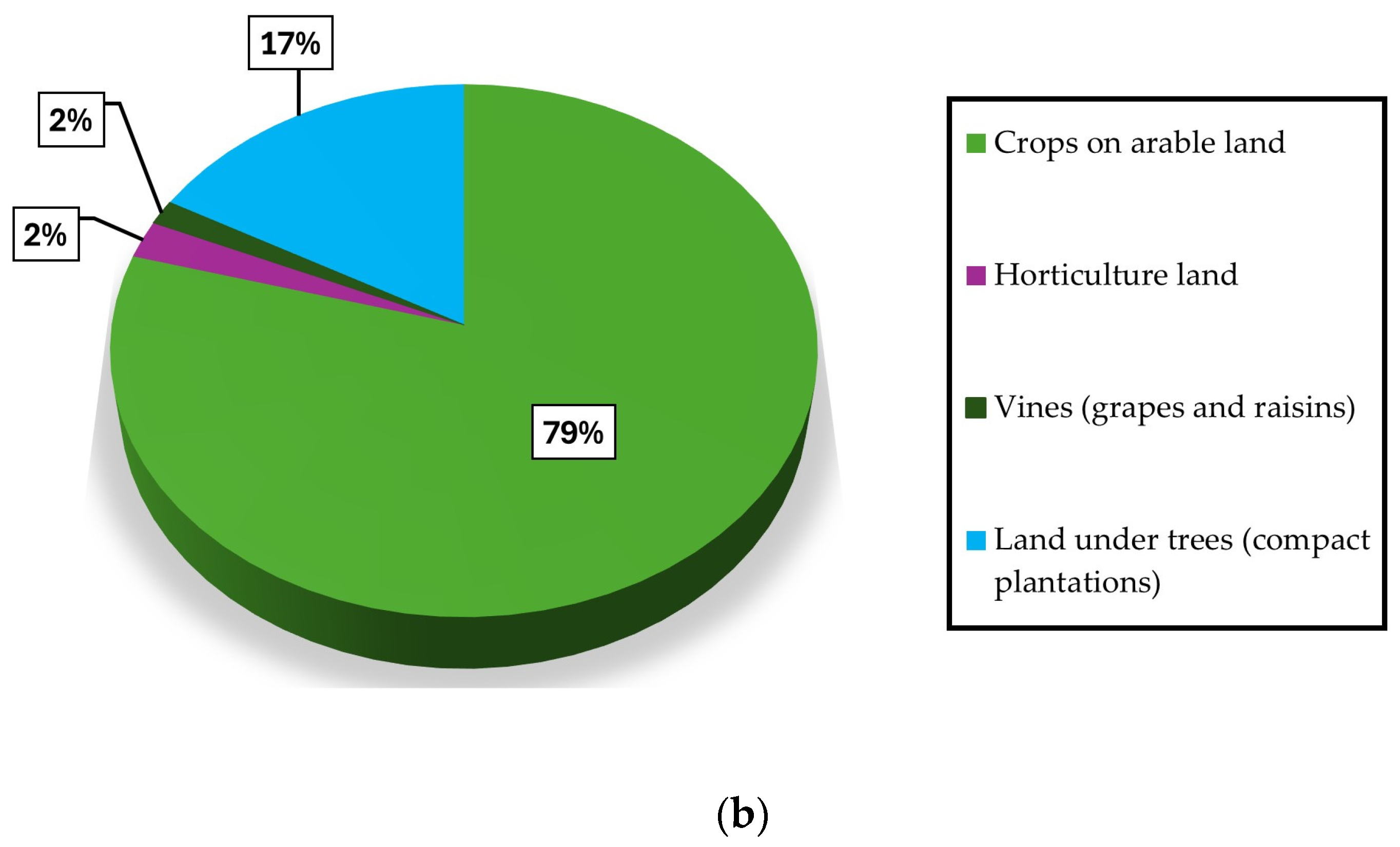
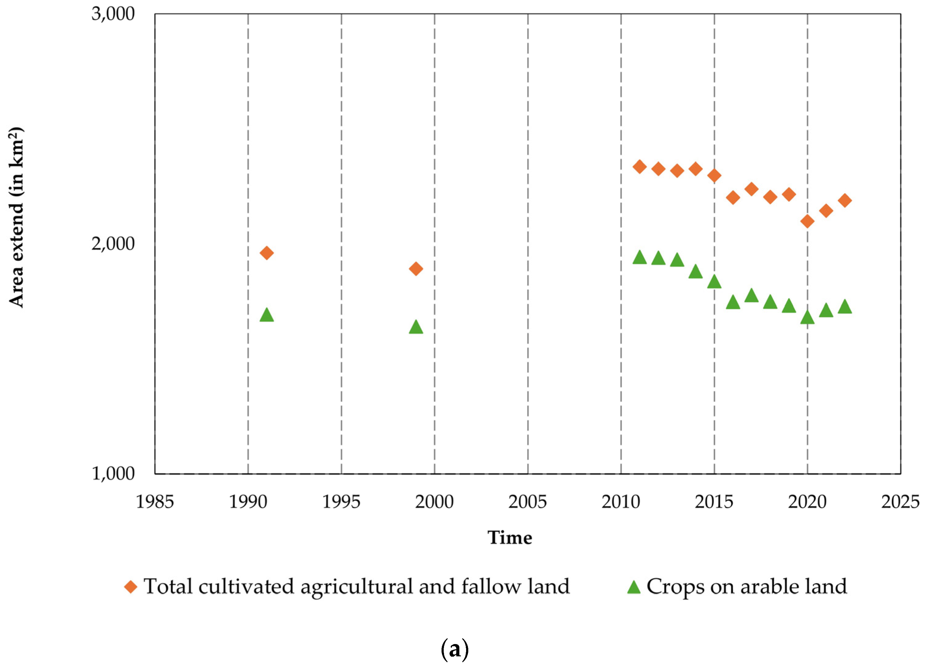
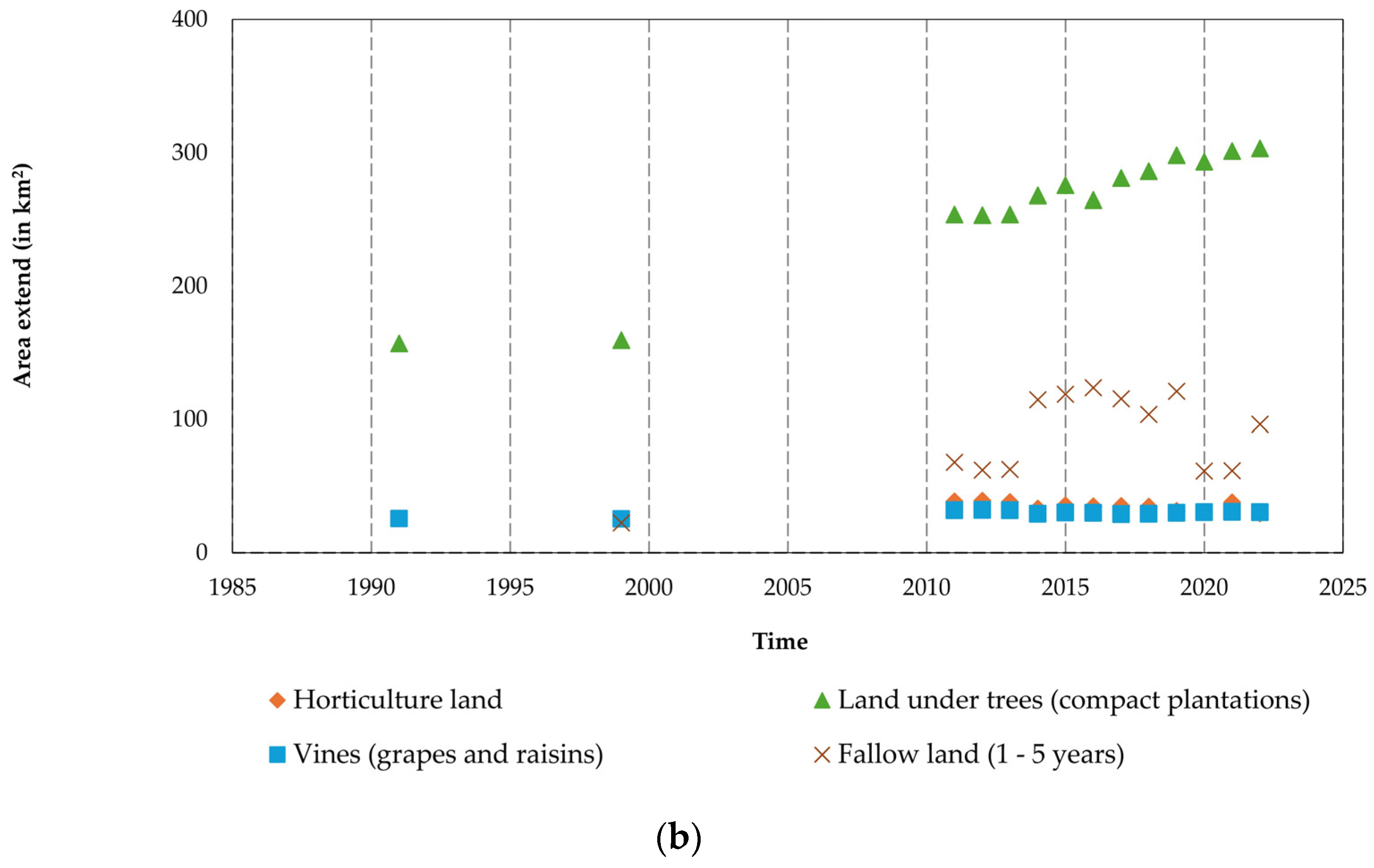
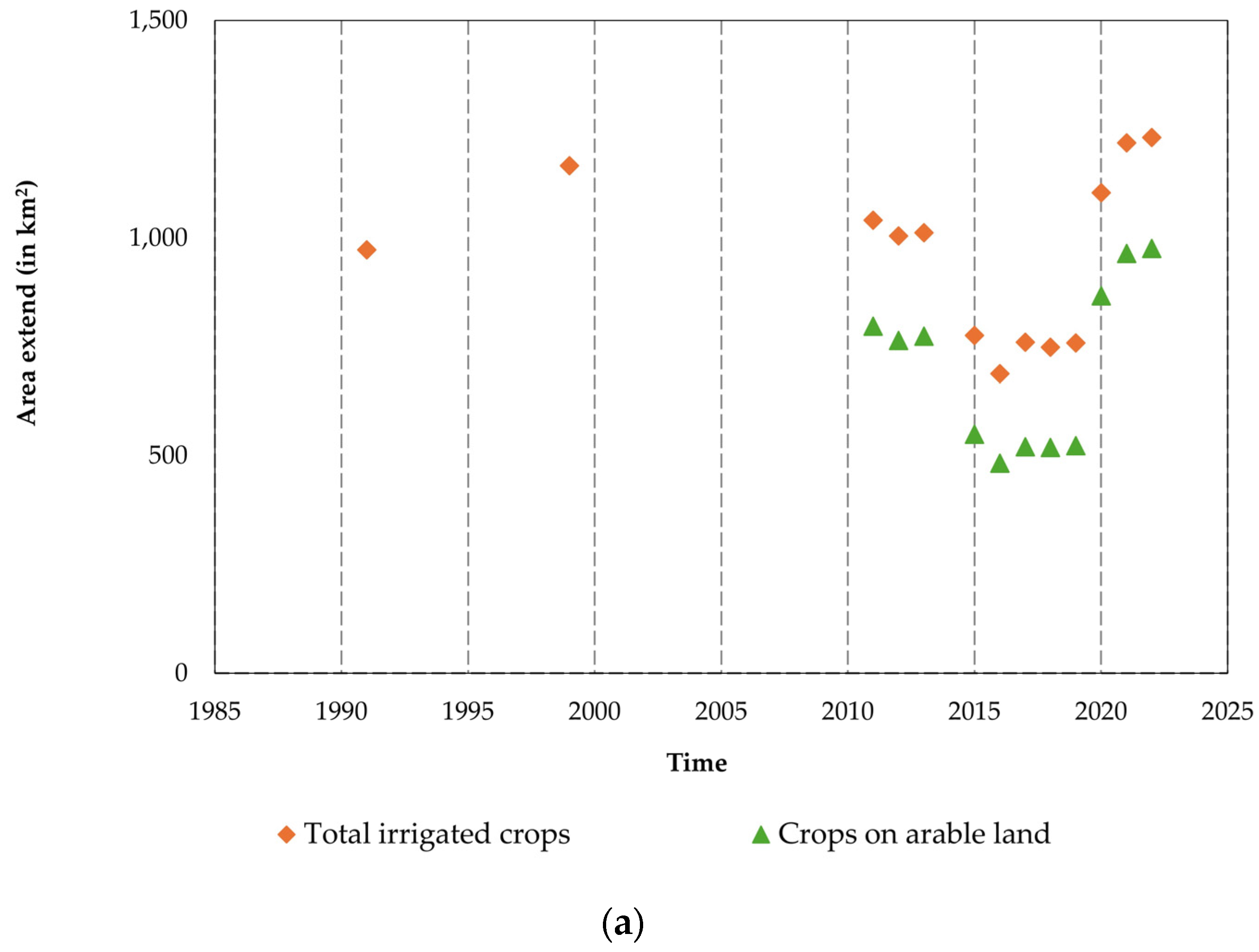
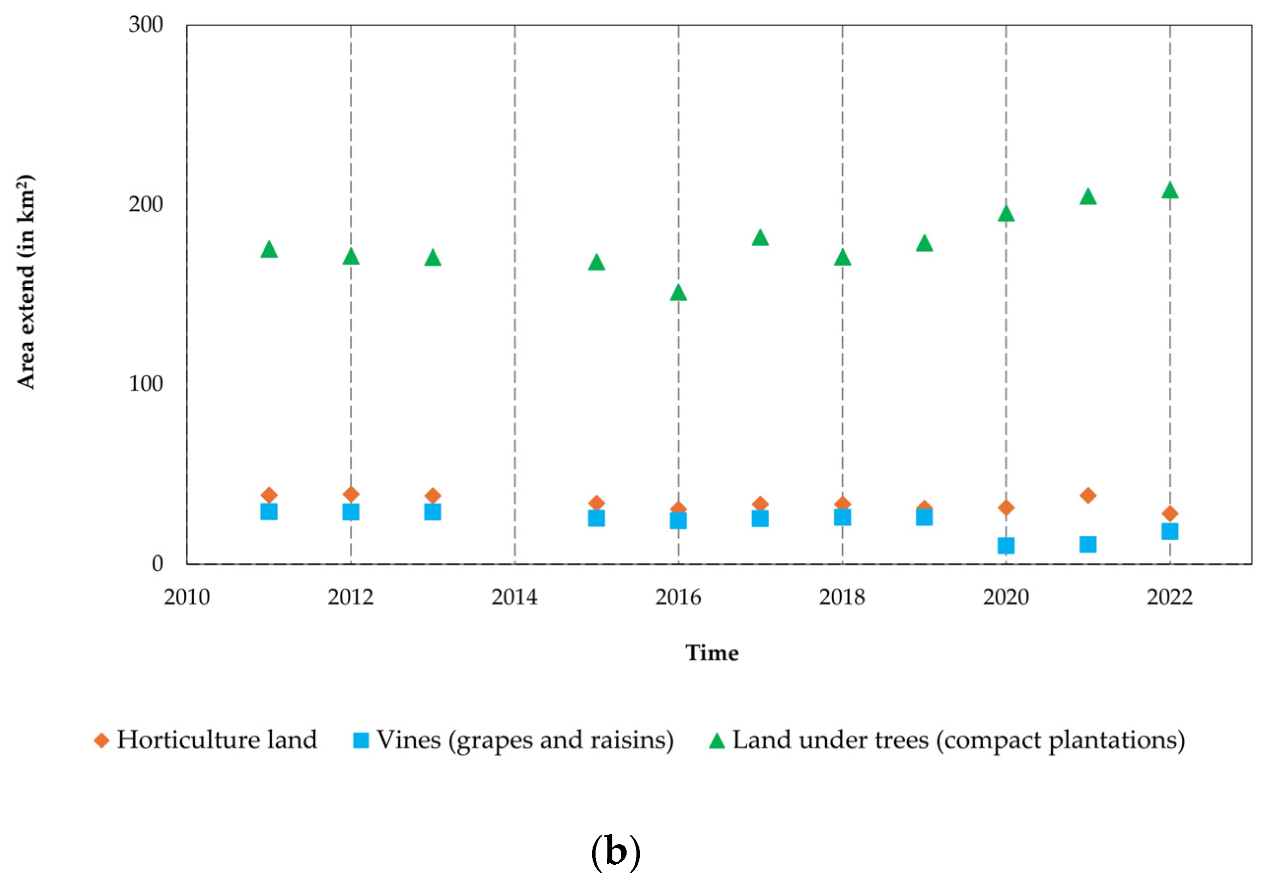
2. Land Use Evolution of the East Thessaly Plain
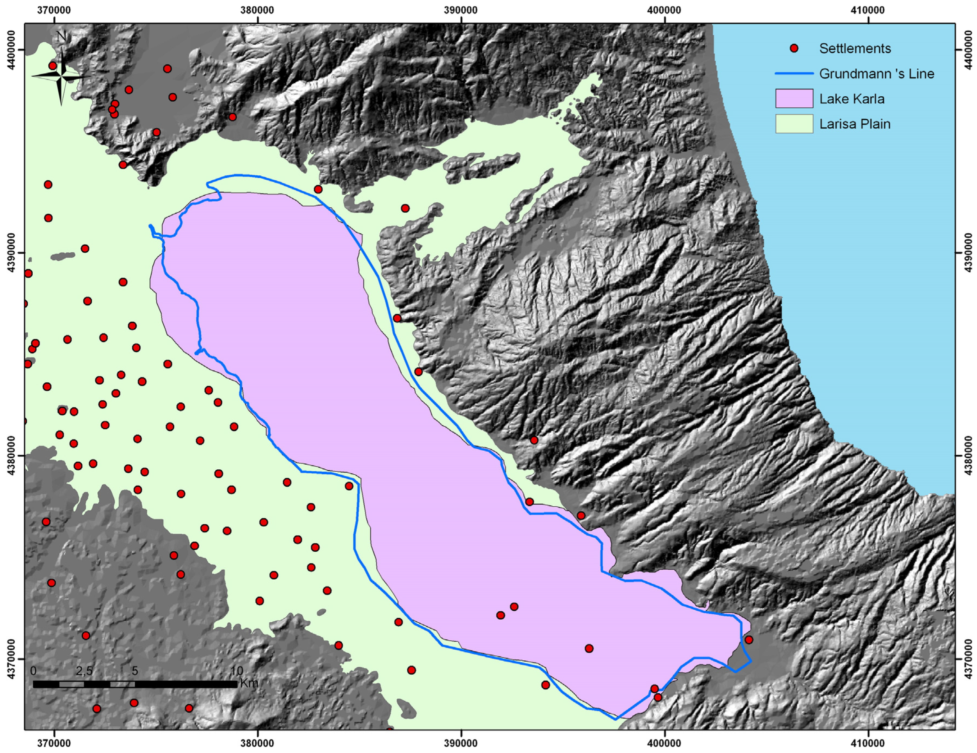


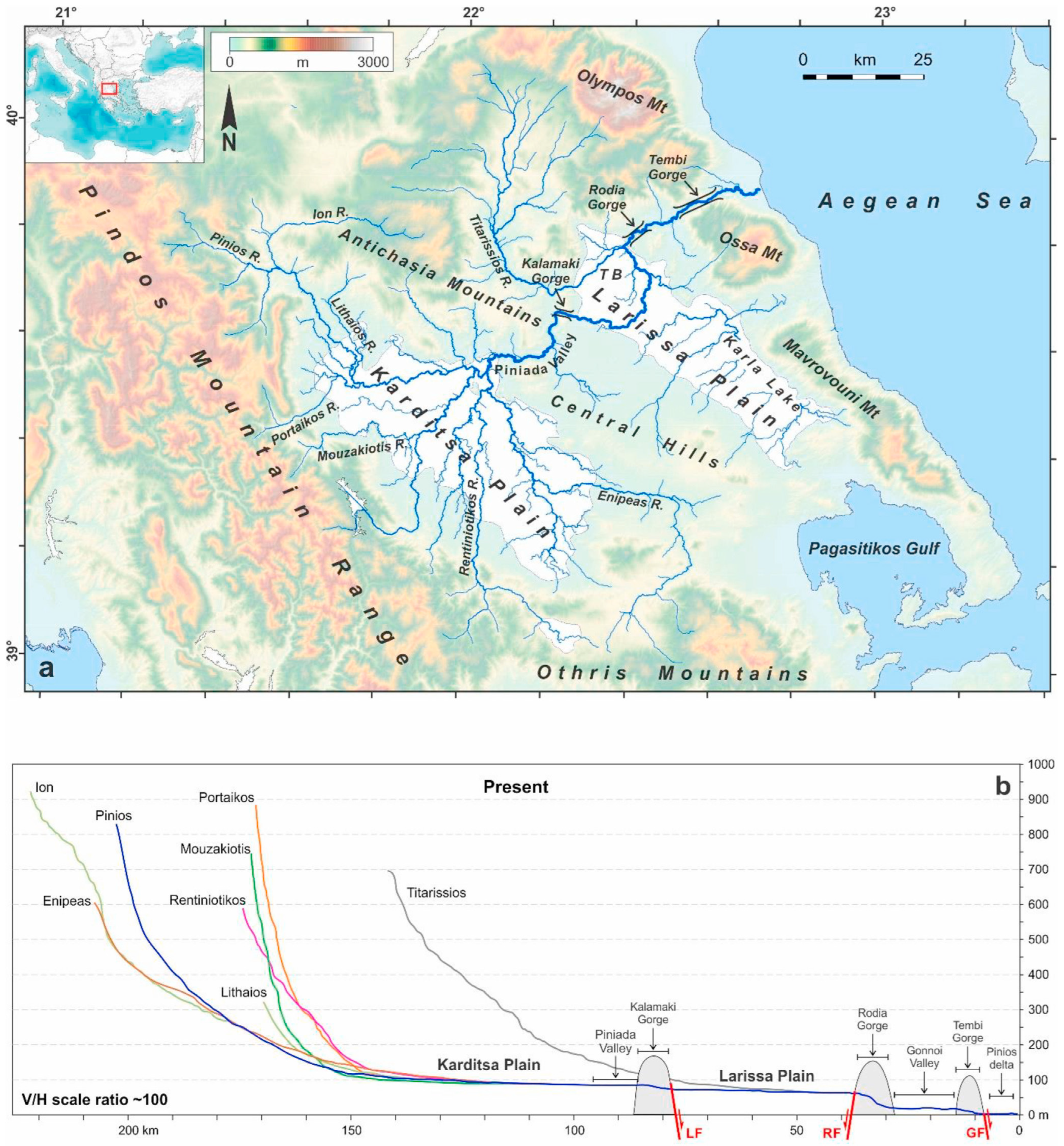
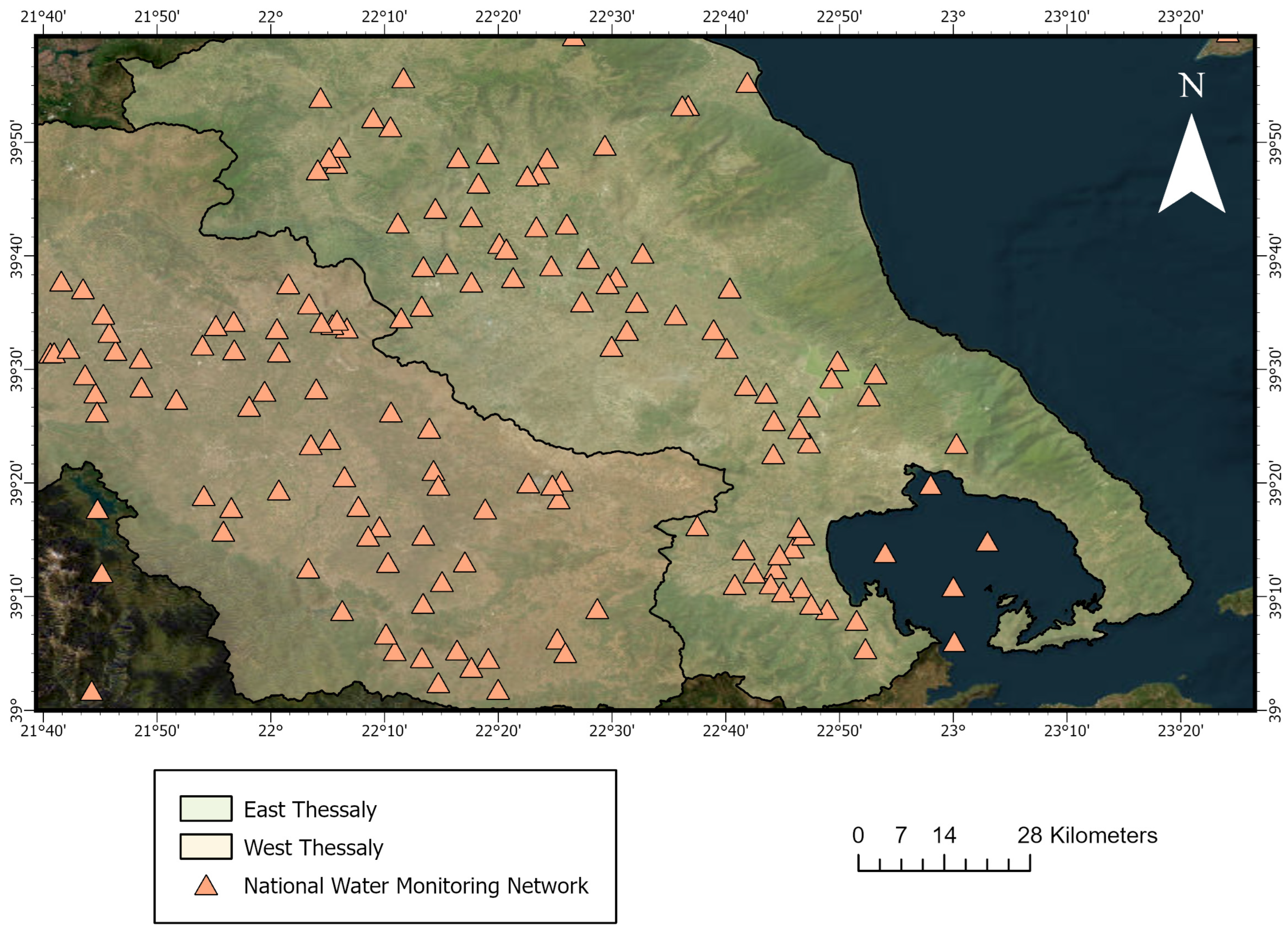
3. Hydrographic Network
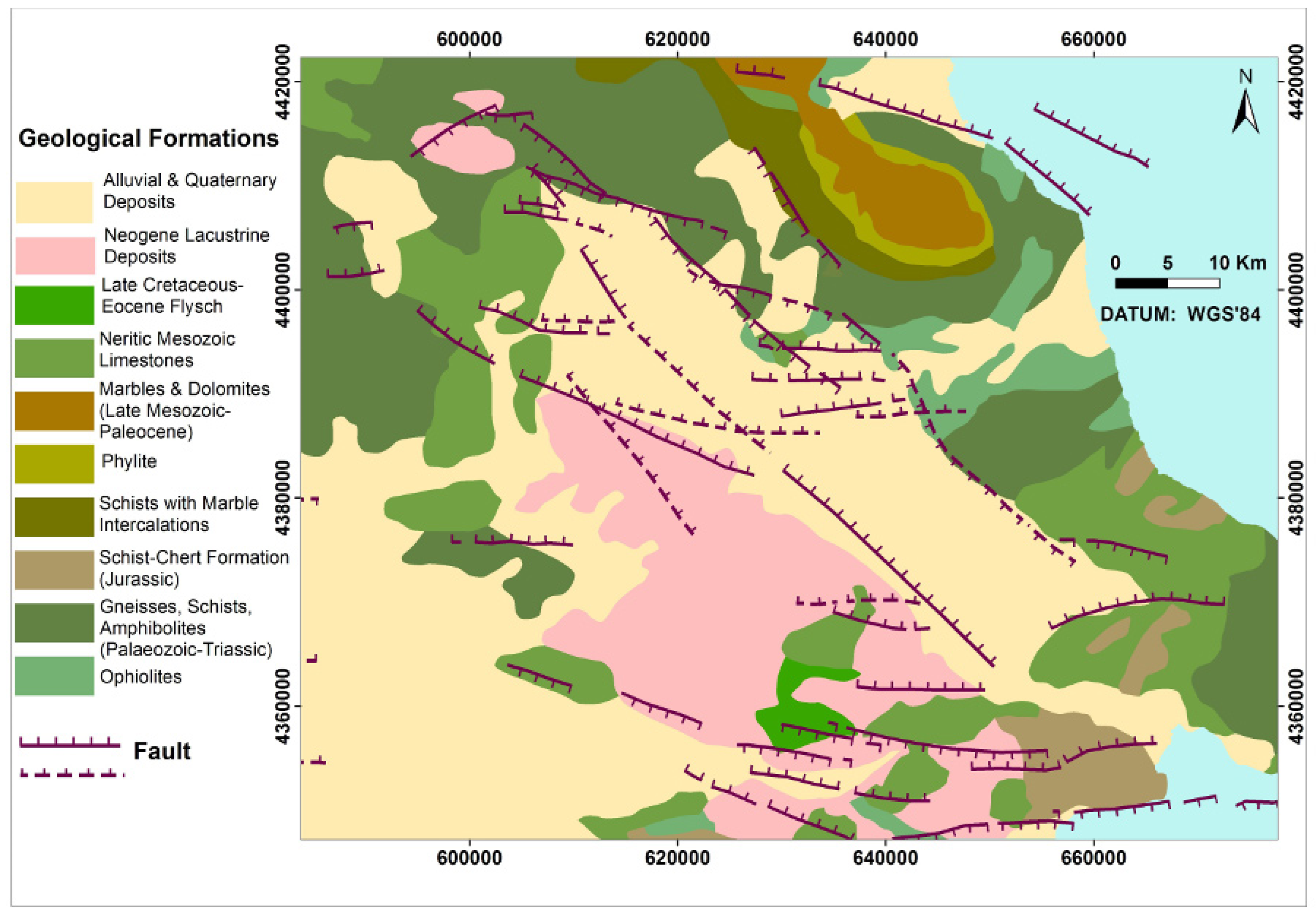
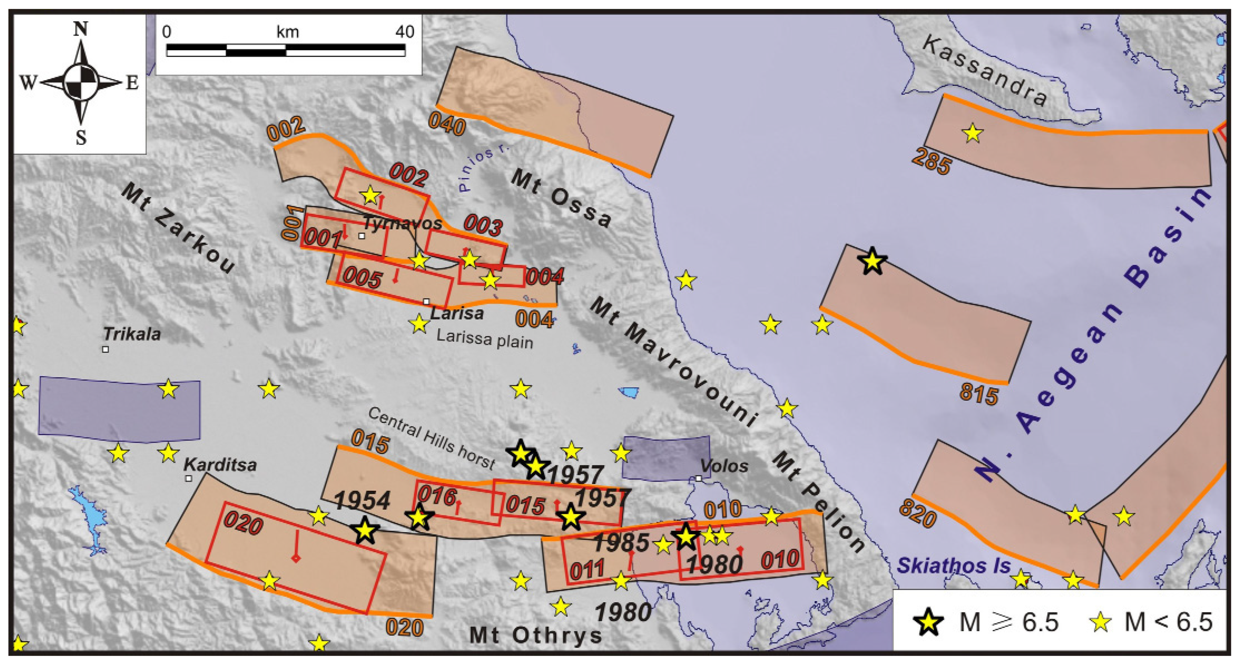
4. Geological Setting
4.1. Wider Study Area
4.2. East Thessaly Plain
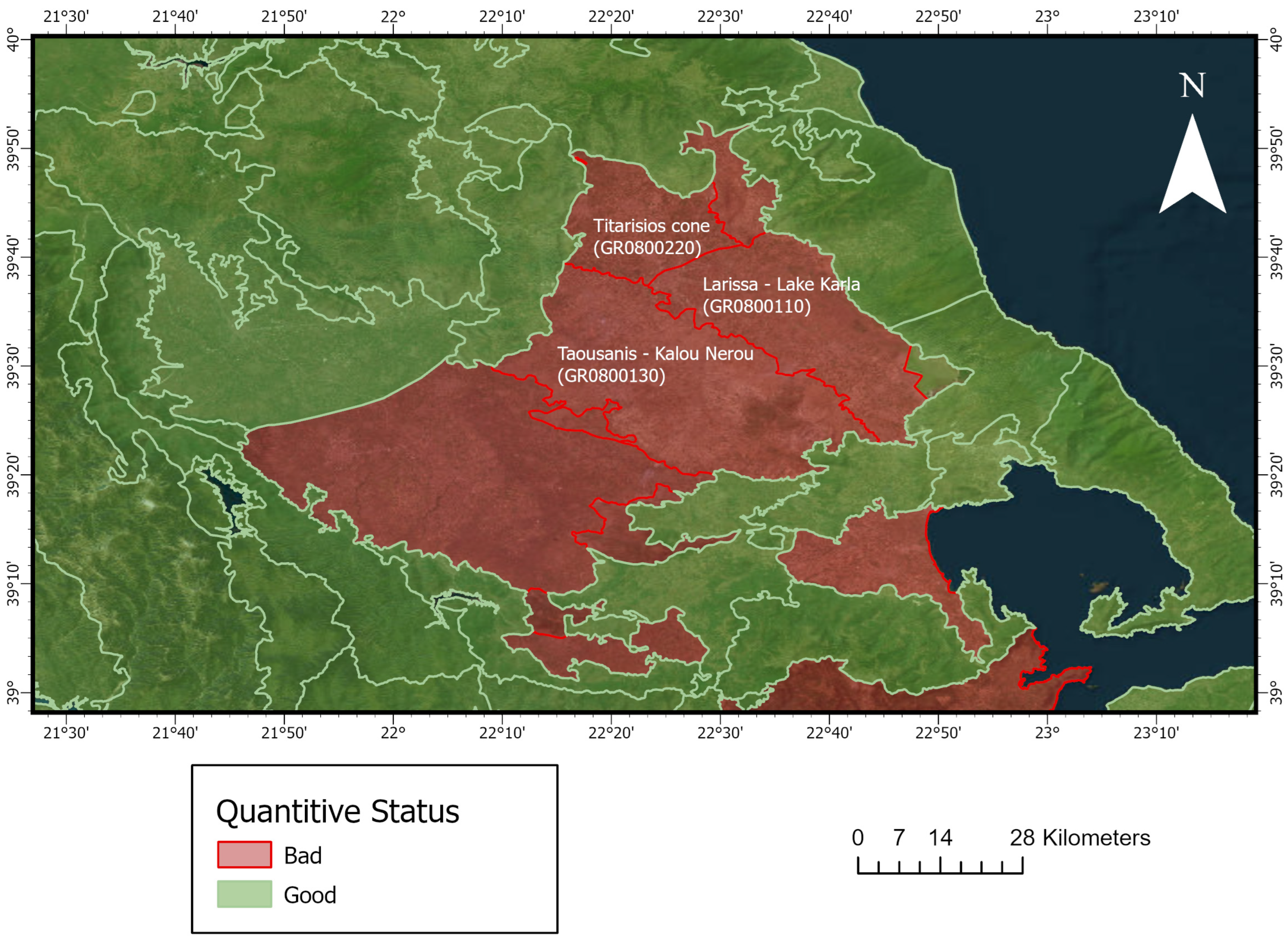
5. Hydrogeological Setting of the East Thessaly Plain
- Unconfined piezometric surface aquifers;
- Confined (under-pressure) aquifers;
- Karst aquifers that develop in carbonate rocks (marble, limestones);
- Fractured rock aquifers (gneiss, shales, ophiolites, flysch).
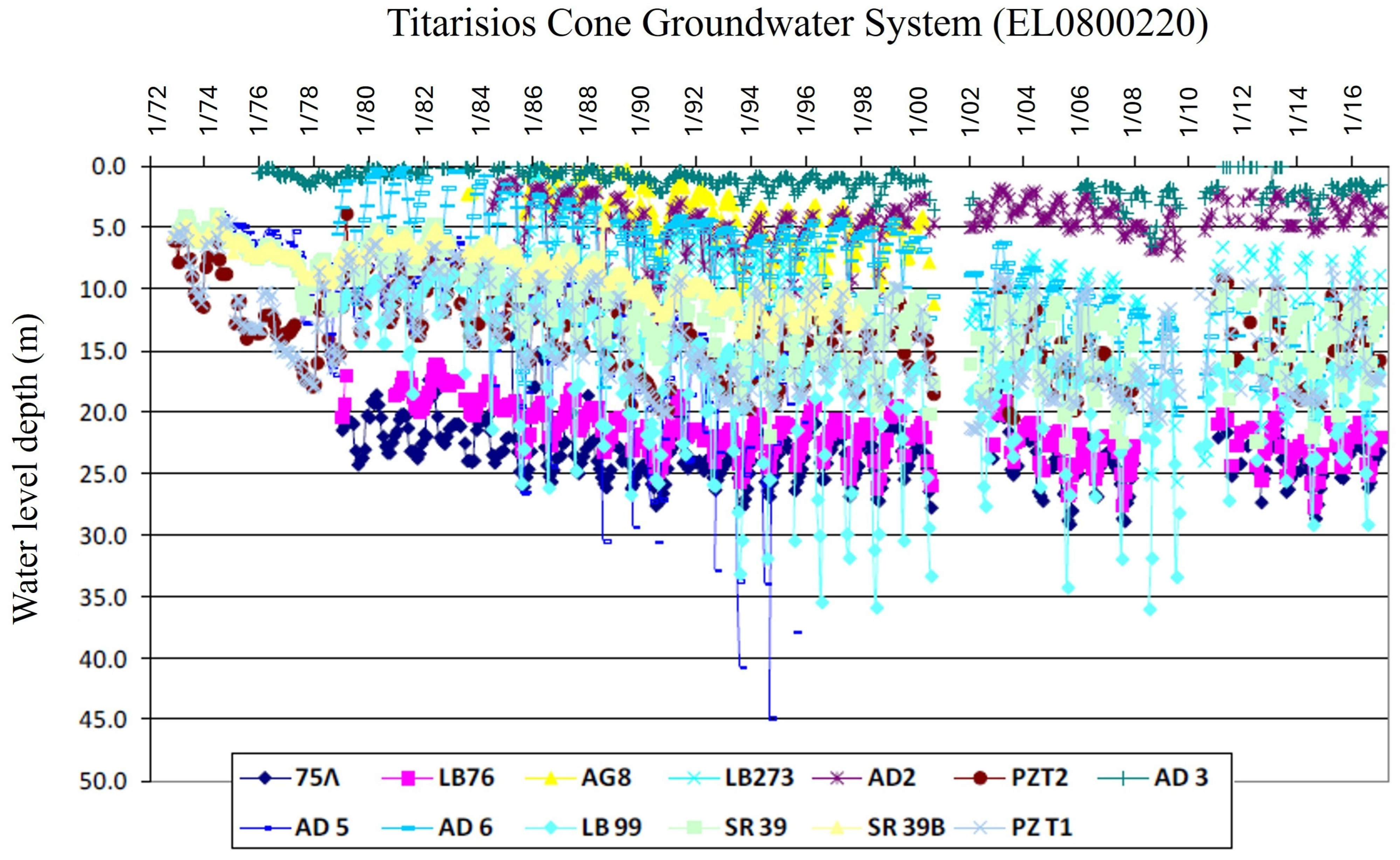
5.1. Titarisios Cone Groundwater System
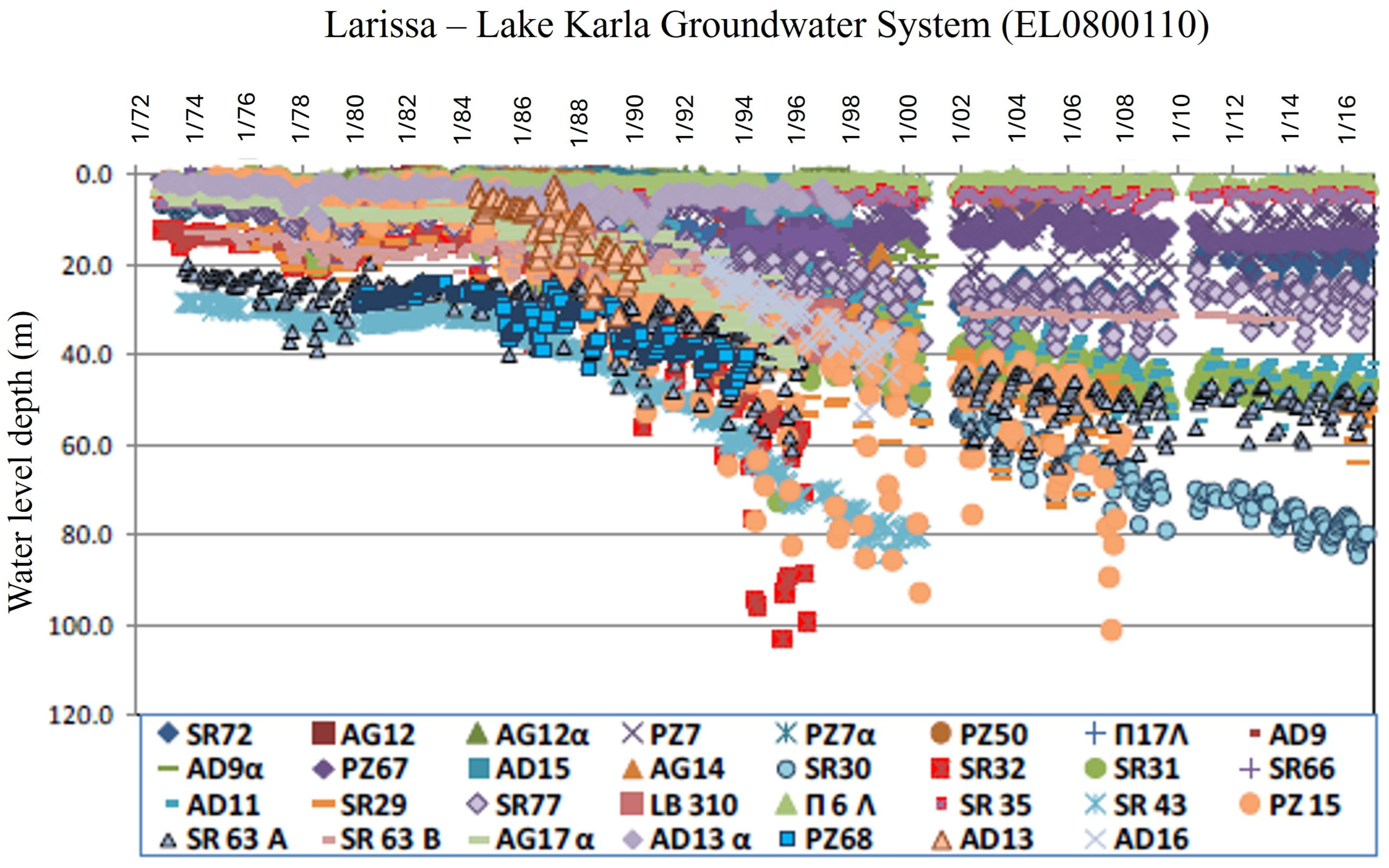
5.2. Larissa–Lake Karla Groundwater System
5.3. Taousanis–Kalou Nerou Groundwater System
6. Over-Pumping Activities in East Thessaly
7. Flood History of Thessaly

| Year | Description |
|---|---|
| 1540 | Thirty days of rainfall resulted in the flooding of Damasi, Larissa |
| 1647 | Twenty-four-hour rainfall in Trikala and Larissa resulted in flooding with over 800 dead |
| 1684 | The flood destroyed part of Larissa, some riverside villages and a large part of arable land. |
| 1729 | Larissa and other areas of Thessaly (Trikala, Moscholouri) suffered significant damages from the great flood of Pineios. |
| 1777 | The flood affected three districts of Larissa and two small settlements around it. Casualties and destruction of houses as well as grain in the plain were reported. |
| 1804 | The Pineios and Koumerkis rivers overflowed, resulting in the inundation of Larissa |
| 1806 | Flood in Larissa |
| 1811 | Intense and prolonged rain caused Pineios to overflow. People and animals were drowned, and houses and crops were destroyed. |
| 1826 | Overflow of the Pineios River causing distractions in Larissa and the surrounding areas |
| 1836 | Extensive flooding in Thessaly Plain affected Larissa, drowning a large number of livestock as well as damaging property and infrastructure. |
| 1872 | Pineios overflowed after intense and prolonged rainfall that caused flooding in a large part of the Thessaly Plain, with a noteworthy impact on agricultural land |
| 1882 | An unprecedented flood hit Larissa when Pineios overflowed. The flood resulted in a large number of flood victims and significant damages. |
| 1883 | An intense 48 h of rainfall resulted in 3 human fatalities, 20 destroyed houses, and incalculable damages. |
| 1902 | The flood of the Pineios River affecting Larissa and Koutsochero, impacting infrastructure and properties |
| 1903 | The flood of the Pineios River affecting Larissa |
| 1907 | A long and strong storm resulted in overflow of the Lithaios and Agia Moni rivers, resulting in flooding of the city of Trikala and the wider area. Human casualties ranged from 100 to 300, with crop damage and dead animals also reported. |
| 1908 | Flood in Pineios River |
| 1920 | The flood in Larissa affected parts of the city near the river |
| 1948 | The flood in Larissa affected property and infrastructure |
| 1963 | The flood of the Pinions River affected Pineiada and other parts of the Thessalian Plain |
| 1987 | Inundation affected the area of Karla Lake, where the water level increased for a few days, damaging agricultural production. |
| 1994 | More than 70 houses in about 20 communities were totally destroyed by the flood. More than 200 houses suffered several damages and 90 minor damages. Almost 80 km2 of agricultural land (cotton fields) were flooded. |
| 2018 | The flood of the Pineios River affected agricultural land near Koutsochero and other locations |
| 2020 | Unprecedented rainfall phenomena affected the whole of Thessaly. The city of Karditsa was flooded, while the village of Metamorfosi was completely submerged in water and mud. Villages in the Palamas and Farsala areas were flooded (Hurricane Ianos). |
| 2023 | Medicane Daniel hits Thessaly, causing extended flooding and damages to infrastructure, human, and animal life loss |
| 2023 | Two weeks after Medicane Daniel, Storm Elias hit further, causing again overflowing of rivers and widespread floods in the region of Thessaly |

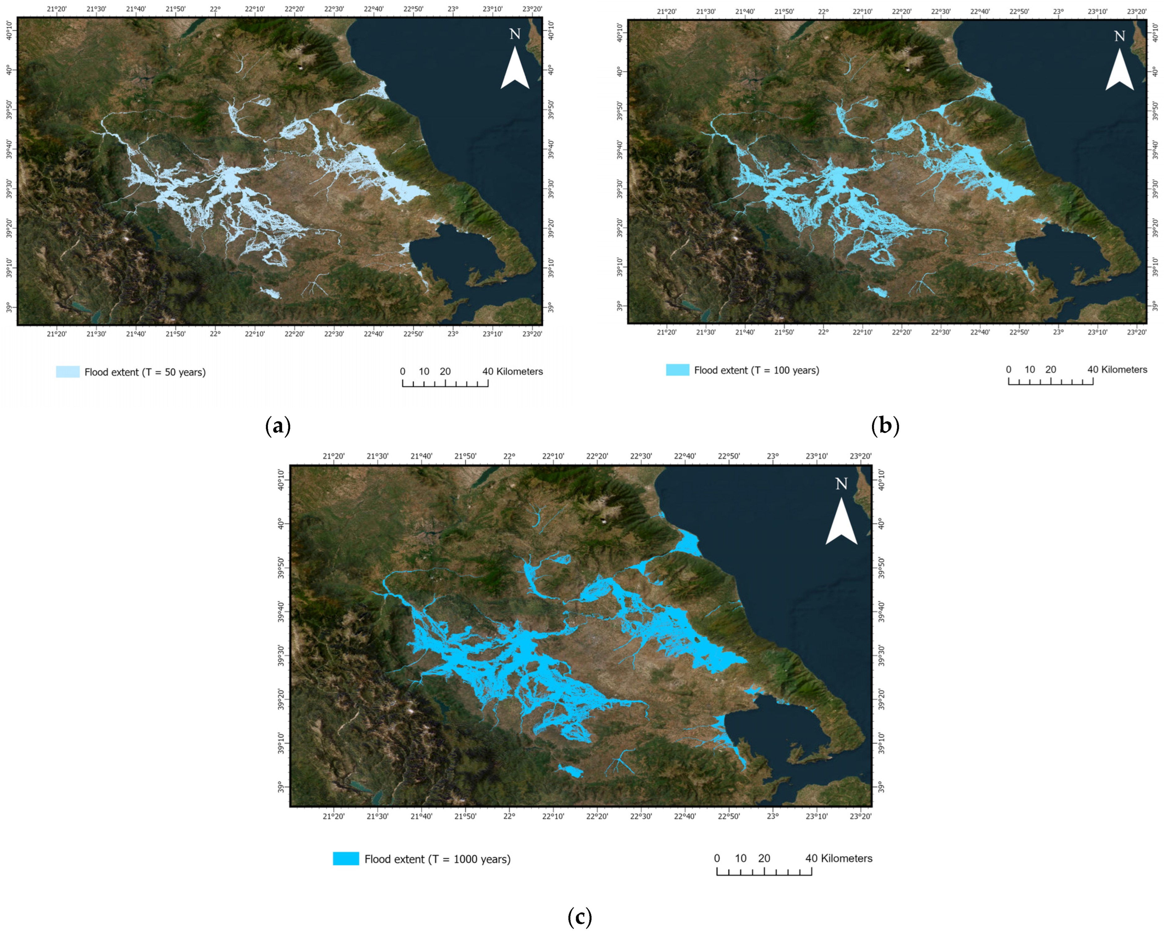
8. Recent Storm and Flooding Events
8.1. Medicane Ianos
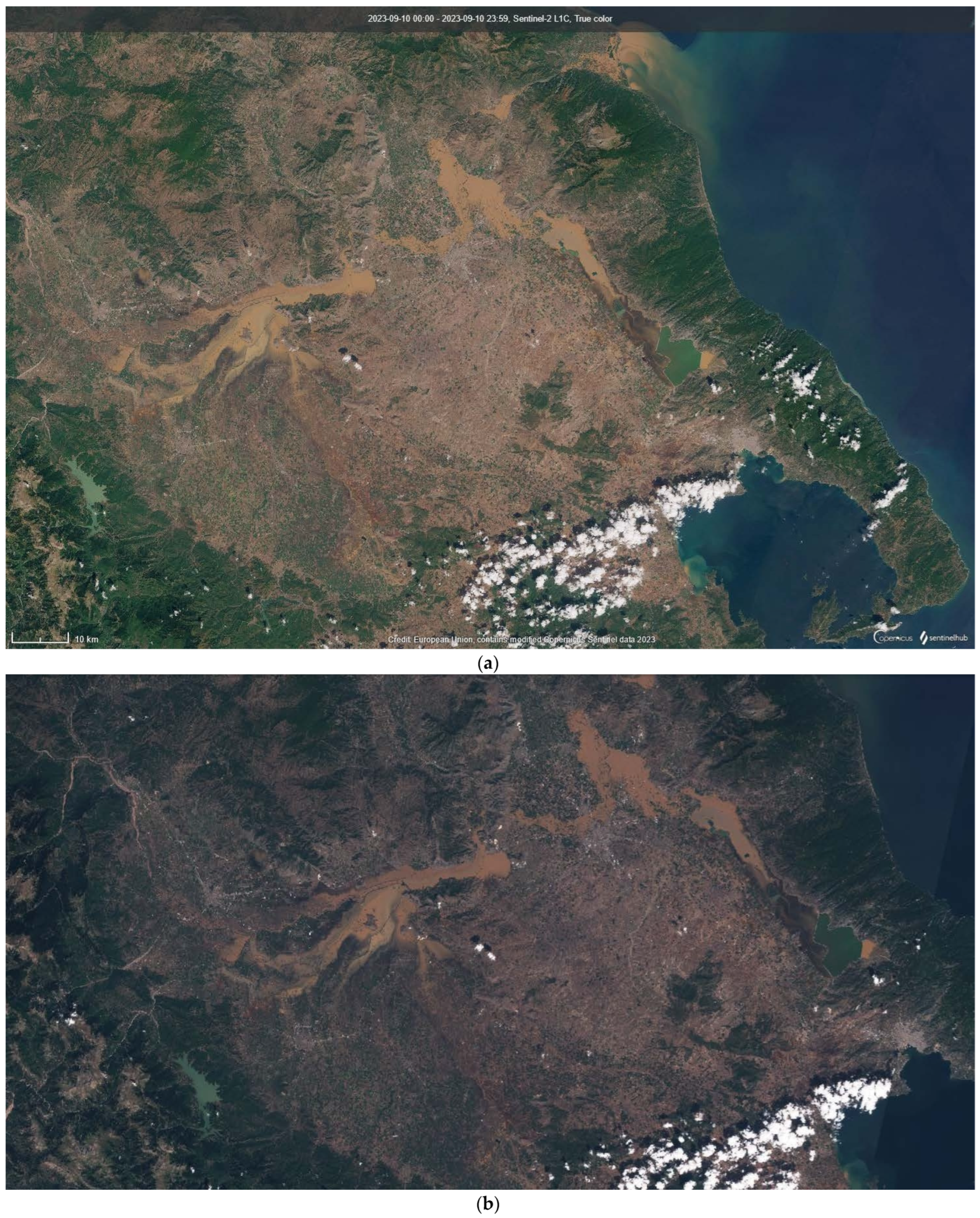
8.2. Medicane Daniel
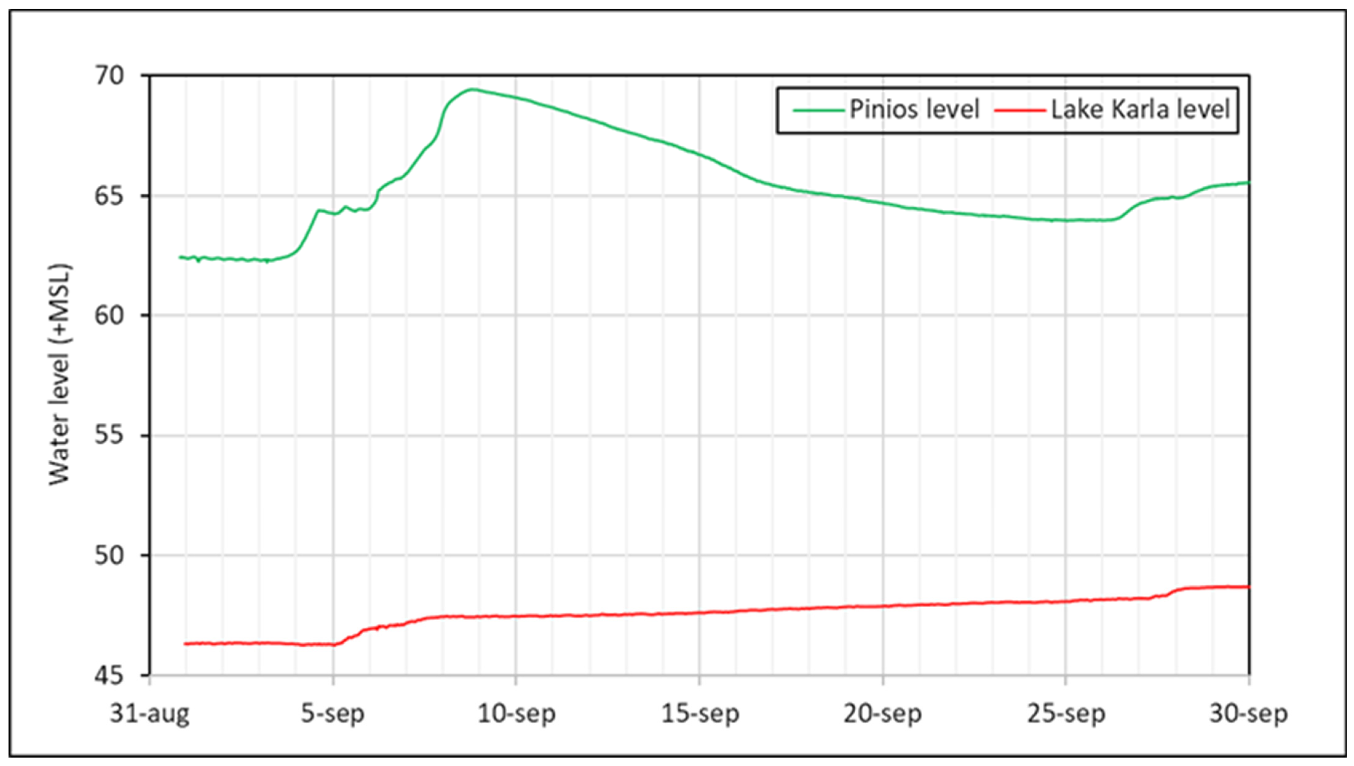
8.2.1. Precipitation
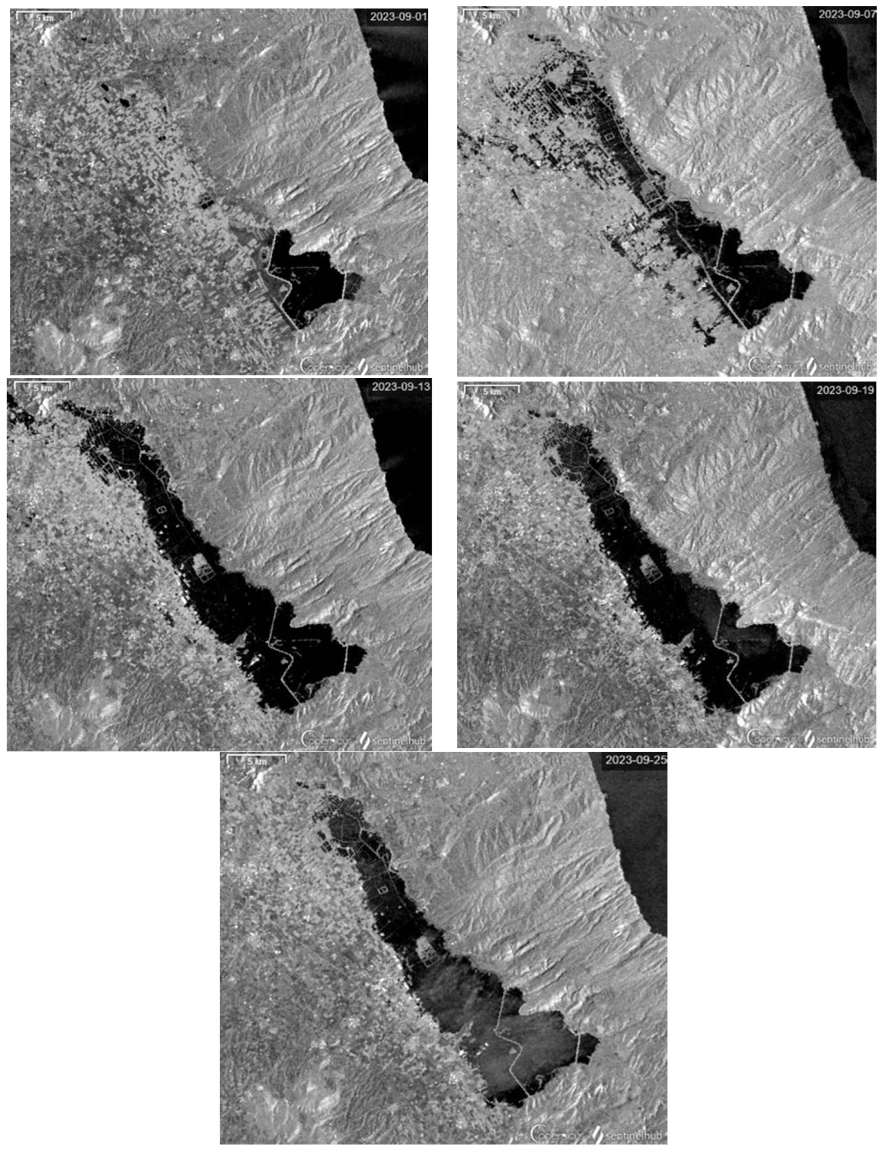
8.2.2. Flooded Areas
8.2.3. Causes
8.3. Storm Elias
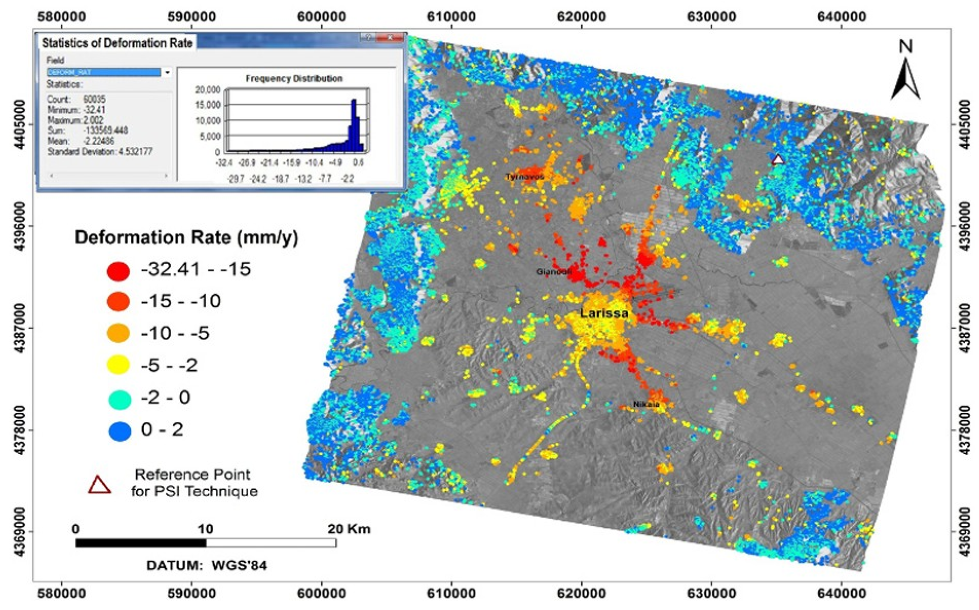
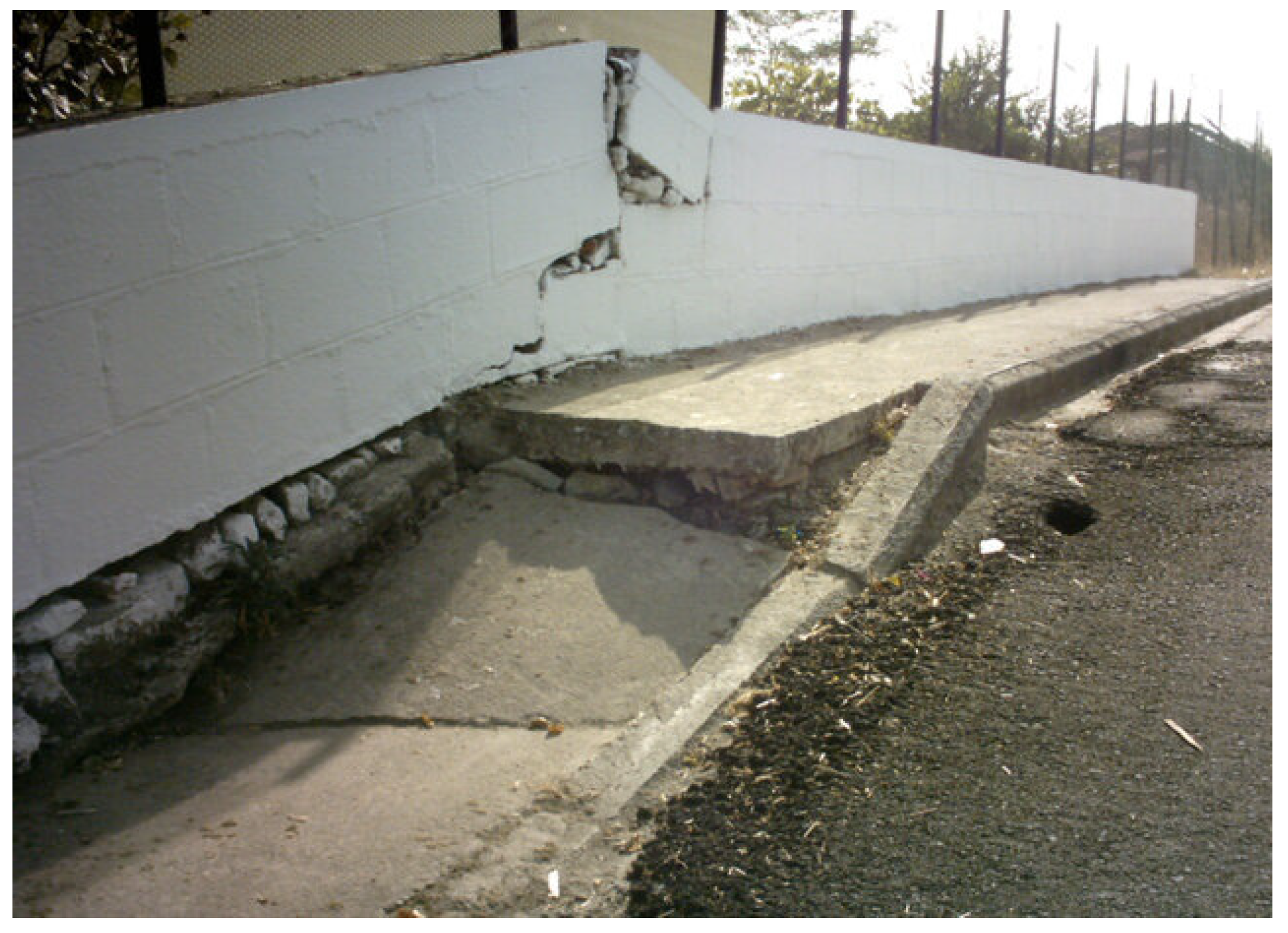
9. Land Subsidence
10. Discussion
11. Conclusions
Supplementary Materials
Author Contributions
Funding
Data Availability Statement
Conflicts of Interest
References
- Handelsvereeniging Amsterdam (HVA) First Report Regarding Post-Disaster Remediation of 2023 Thessaly Flooding. 2023. Available online: https://www.government.gov.gr/wp-content/uploads/2023/11/HVA-Fact-Finding-Mission-Report-on-Thessaly-Post-Disaster-Remediation.pdf (accessed on 2 February 2025).
- Markatou, M. Creating an Identity for Thessaly by Exploiting the Primordial Superiority of the Thessalian Landscape. In Proceedings of the Thessaly of tomorrow—The view of the TEE of Central & Western Thessaly, Larissa, Greece, 25 September 2019; Available online: https://tee-kdth.gr/wp-content/uploads/2019/09/markatou.pdf (accessed on 21 November 2024). (In Greek).
- Thermou, M. Same Image: The Thessalian Plain Today, as It Was 10,000 Years Ago. Available online: https://www.mononews.gr/politismos/idia-ikona-o-thessalikos-kampos-simera-opos-prin-apo-10-000-chronia (accessed on 21 November 2024). (In Greek).
- Grundmann, Κ. Hadzimissiotiki Magoula. Athenische Mitteilungen 1937, 62, 56–69. [Google Scholar]
- Alexakis, D.; Sarris, A.; Astaras, T.; Albanakis, K. Integrated GIS, Remote Sensing and Geomorphologic Approaches for the Reconstruction of the Landscape Habitation of Thessaly during the Neolithic Period. J. Archaeol. Sci. 2011, 38, 89–100. [Google Scholar] [CrossRef]
- Kypraiou, C. Flood Phenomena and Risk Management: Case Study of Pinios River and Larissa Plain. Master’s Thesis, Inter-Institutional Postgraduate Program “Natural Disaster Prevention and Management”, Athens, Greece, 2012. Available online: https://pergamos.lib.uoa.gr/uoa/dl/object/1319443 (accessed on 29 January 2025).
- Tsountas, C. The Prehistoric Acropolis of Dimini And Sesklos, 2000th ed.; Archaeological Society of Athens: Athens, Greece, 1908; ISBN 9608145058. (In Greek) [Google Scholar]
- Helly, B.; Bravard, J.P.; Caputo, R. The Eastern Thessaly Plain: Changes in Historical Landscapes and Alluvial Evolution. In Thessalian Calendar; Samaras, K., Ed.; Kostas Spanos: Larissa, Greece, 2000; Volume 38, pp. 3–35. (In Greek) [Google Scholar]
- Helly, B.; Bravard, J.-P.; Caputo, R. The Eastern Thessaly Plain: Changes in Historical Landscapes and Alluvial Evolution. In Thessalian Calendar; Samaras, K., Ed.; Kostas Spanos: Larissa, Greece, 2001; Volume 39, pp. 73–96. (In Greek) [Google Scholar]
- Helly, B.; Bravard, J.-P.; Caputo, R. The Eastern Thessaly Plain: Changes in Historical Landscapes and Alluvial Evolution. In Thessalian Calendar; Samaras, K., Ed.; Kostas Spanos: Larissa, Greece, 2001; Volume 40, pp. 145–164. (In Greek) [Google Scholar]
- Helly, B.; Bravard, J.-P.; Caputo, R. The Eastern Thessaly Plain: Changes in Historical Landscapes and Alluvial Evolution. In Thessalian Calendar; Samaras, K., Ed.; Kostas Spanos: Larissa, Greece, 2002; Volume 41, pp. 165–190. (In Greek) [Google Scholar]
- Pantzouris, K. The Residential Development in Ancient Thessaly, from the Archaic to the Roman Period. Bachelor Thesis, National Kapodistrian University of Athens, Athens, Greece, 2021. Available online: https://pergamos.lib.uoa.gr/uoa/dl/object/2931647 (accessed on 4 January 2025). (In Greek).
- Karambinis, M. Urban Networks in the Roman Province of Achaia (Peloponnese, Central Greece, Epirus and Thessaly). J. Greek Archaeol. 2018, 3, 241–269. [Google Scholar] [CrossRef]
- Garnsey, P.; Gallant, T.; Rathbone, D. Thessaly and the Grain Supply of Rome during the Second Century B.C. J. Rom. Stud. 1984, 74, 30–44. [Google Scholar] [CrossRef]
- Manolidis, K. The Plain of Thessaly, the Awe of the Plain. Available online: https://www.greekscapes.gr/index.php/2010-01-21-16-47-29/landscapescat/57-2009-07-31-09-46-11/98-kampos-thessalias (accessed on 21 November 2024). (In Greek).
- When the Thessalian Plain Was One Large Lake, or… Maybe Two? Available online: https://www.thessaliatv.gr/news/7183/otan-h-thessalikh-pediada-htan-mia-megalh-limnh-h-mhpws-dyo (accessed on 21 November 2024). (In Greek).
- Goumas, K. The Evolution of Projects to Address Water Problems in Thessaly. Available online: https://www.ypethe.gr/opinion/i-exelixi-ton-ergon-gia-tin-antimetopisi-ton-ydatikon-provlimaton-sti-thessalia (accessed on 3 February 2025). (In Greek).
- Karla Lake Culture Museum. Available online: https://boebes-karla.gr/ (accessed on 21 November 2024).
- Lialios, G. Opening Ceremony of the “New” Lake Karla. Kathimerini. 2018. Available online: https://www.kathimerini.gr/society/988425/egkainia-gia-ti-nea-limni-karla/ (accessed on 9 January 2025). (In Greek).
- Arapostathis, E.; Vlachos, G.; Gousios, D.; Danalatos, N.; Iliou, N.; Tsimpoukas, K. Agricultural Development Plan of Thessaly. 2024. Available online: https://www.thessaly.gov.gr/images/right/sxedio.pdf (accessed on 9 December 2024). (In Greek)
- Lake Karla. The Drainage and Ecological Upheaval. Available online: https://www.mixanitouxronou.gr/i-ikona-pou-thimizi-erimo-itan-o-defteros-megaliteros-idroviotopos-stin-ellada-apoxiranthike-to-1962-prokalontas-ikologiki-katastrofi-simera-ginete-prospathia-gia-anadimiourgia-tis-limnis-foto-vi/ (accessed on 9 February 2025). (In Greek).
- Livadiotis, E.; Troudi, N.; Gharbia, N.B.; Tzoraki, O. Evaluating the Land Use/Land Cover Change with a Future Prediction Using Remote Sensing and GIS in the Elassona-Tsaritsani Basin of Thessaly (Central Greece). In Recent Advances in Environmental Science from the Euro-Mediterranean and Surrounding Regions; Springer: Cham, Switzerland, 2024; pp. 709–713. [Google Scholar] [CrossRef]
- Alamanos, A.; Koundouri, P.; Papadaki, L.; Pliakou, T. A System Innovation Approach for Science-Stakeholder Interface: Theory and Application to Water-Land-Food-Energy Nexus. Front. Water 2022, 3, 744773. [Google Scholar] [CrossRef]
- Vrouchakis, I. Hydrogeological Research Using Modern Management Tools in the Framework of Qualitative and Quantitative Monitoring of the Groundwater System of Tirnavos Sub-Basin (Thessaly). Ph.D. Dissertation, School of Environment and Agricultural Engineering, Agricultural University of Athens, Athens, Greece, 2022. [Google Scholar] [CrossRef]
- Manakos, A. Hydrogeological Study—Water District of Thessaly. 3rd CSF, Subproject: Underground Water Potential of Thessaly; Institute of Geology and Mineral Exploration (IGME): Thessaloniki, Greece, 2010. (In Greek) [Google Scholar]
- Kallergis, G.; Morphis, A.; Papaspyropoulos, X.; Christodoulou, T. Hydrogeological Survey of the Western Thessaly Basin—Hydrological and Hydrogeological Surveys; Institute of Geology and Mineral Exploration (IGME): Acharnes, Greece, 1973. (In Greek) [Google Scholar]
- Caputo, R.; Helly, B.; Rapti, D.; Valkaniotis, S. Late Quaternary Hydrographic Evolution in Thessaly (Central Greece): The Crucial Role of the Piniada Valley. Quat. Int. 2022, 635, 3–19. [Google Scholar] [CrossRef]
- Aubouin, J. Contribution à l’ Étude Géologique de La Grèce Septentrionale: Le Confins de l’ Epire et de La Thessalie. Annales Géologiques des Pays Helléniques 1959, 10, 525. [Google Scholar]
- Demitrack, A. The Late Quaternary Geologic History of The Larissa Plain Thessaly, Greece: Tectonic, Climatic, and Human Impact on The Landscape (Soil Stratigraphy, Neolithic Period, Pinios River, Uranium/Thorium Disequilibrium Dating). Doctoral Dissertation, Stanford University, 1986. Available online: https://www.proquest.com/openview/61b2f5074024170c6e51cb5f90ff9a40/1?cbl=18750&diss=y&pq-origsite=gscholar (accessed on 2 December 2024).
- Lekkas, E. Geological Structure and Geodynamics Evolution of the Koziakas Mountain Range (Western Thessaly). Ph.D. Dissertation, National and Kapodistrian University of Athens, Athens, Greece, 1988. (In Greek). [Google Scholar] [CrossRef]
- Caputo, R. Geological and Structural Study of the Recent and Active Brittle Deformation of the Neogene-Quaternary Basins of Thessaly (Central Greece). Doctoral Dissertation, Aristotle University of Thessaloniki, Thessaloniki, Greece, 1990. Available online: http://hdl.handle.net/11392/464019 (accessed on 2 December 2024).
- Caputo, R. Late Quaternary Faulting in Thessaly, Greece. In Proceedings of the Congress on Recent Crustal Movements; Geological Society of Japan: Kobe, Japan, 1994; pp. 397–399. [Google Scholar]
- Caputo, R.; Pavlidis, S. Neotectonic Structure and Evolution of Thessaly. Bull. Geol. Soc. Greece 1991. Available online: https://ikee.lib.auth.gr/record/253196 (accessed on 13 January 2025). (In Greek).
- Caputo, R.; Pavlides, S. Late Cainozoic Geodynamic Evolution of Thessaly and Surroundings (Central-Northern Greece). Tectonophysics 1993, 223, 339–362. [Google Scholar] [CrossRef]
- Caputo, R.; Bravard, J.-P.; Helly, B. The Pliocene-Quaternary Tecto-Sedimentary Evolution of the Larissa Plain (Eastern Thessaly, Greece). Geodin. Acta 1994, 7, 219–231. [Google Scholar] [CrossRef]
- Brunn, J.H. Contribution à l’étude Géologique Du Pinde Septentrional et d’une Partie de La Macédoine Occidentale. In Annales Géologiques des Pays Helléniques; Département des Sciences de la Terre de l’ Université d’ Athènes: Athens, Greece, 1956; Volume 7. [Google Scholar]
- Alexopoulos, J.D.; Dilalos, S.; Poulos, S.E.; Giannopoulos, I.-K.; Gkosios, V. Geophysical Investigation of the Ground Fissures and Ground Subsidence near Karla Lake (Eastern Thessaly Basin, Greece). Phys. Chem. Earth Parts A/B/C 2024, 136, 103764. [Google Scholar] [CrossRef]
- Sogreah, S. Groundwater Development Project of the Plain of Thessaly; Republic of Greece, Ministry of Agriculture, Directorate General of Agricultural Development and Research Land Reclamation Service: Athens, Greece, 1974. [Google Scholar]
- Caputo, R. Inference of a Seismic Gap from Geological Data: Thessaly (Central Greece) as a Case Study. Ann. Geophys. 1995, 38, 1–19. [Google Scholar] [CrossRef]
- Apostolidis, E. Engineering-Geological Conditions in the Western Thessaly Basin. Ph.D. Dissertation, University of Patras, School of Sciences, Patras, Greece, 2014. (In Greek). [Google Scholar] [CrossRef]
- Psilovikos, A. The Evolution of the Pinios River in Thessaly. In Trikalina, Proceedings of the 2nd Symposium on Trikala Studies; F.I.L.O.S.: Singapore, 1991; Volume 11, pp. 441–454. (In Greek) [Google Scholar]
- Athanassiou, A. Neogene and Quaternary Mammal Faunas of Thessaly. Annales Géologiques des Pays Helléniques 2002, XXXIX, 279–293. Available online: https://doc.rero.ch/record/13602/files/PAL_E356.pdf (accessed on 9 February 2025).
- Vassilopoulou, S.; Sakkas, V.; Wegmuller, U.; Capes, R. Long Term and Seasonal Ground Deformation Monitoring of Larissa Plain (Central Greece) by Persistent Scattering Interferometry. Open Geosci. 2013, 5, 61–76. [Google Scholar] [CrossRef]
- Doutsos, T.; Pe-Piper, G.; Boronkay, K.; Koukouvelas, I. Kinematics of the Central Hellenides. Tectonics 1993, 12, 936–953. [Google Scholar] [CrossRef]
- Doutsos, T.; Koukouvelas, I.; Zelilidas, A.; Kontopoulos, N. Intracontinental Wedging and Post-Orogenic Collapse in the Mesohellenic Trough. In Active Continental Margins—Present and Past; Springer: Berlin/Heidelberg, Germany, 1994; pp. 257–275. [Google Scholar] [CrossRef]
- Mercier, J.L.; Sorel, D.; Vergely, P.; Simeakis, K. Extensional Tectonic Regimes in the Aegean Basins during the Cenozoic. Basin Res. 1989, 2, 49–71. [Google Scholar] [CrossRef]
- Kokkalas, S.; Xypolias, P.; Koukouvelas, I.; Doutsos, T. Postcollisional Contractional and Extensional Deformation in the Aegean Region. In Postcollisional Tectonics and Magmatism in the Mediterranean Region and Asia; Geological Society of America Special Papers (409) 97-123: Boulder, CO, USA, 2006. [Google Scholar] [CrossRef]
- Papadimitriou, E.E.; Karakostas, V.G. Episodic Occurrence of Strong (Mw≥6.2) Earthquakes in Thessalia Area (Central Greece). Earth Planet. Sci. Lett. 2003, 215, 395–409. [Google Scholar] [CrossRef]
- Ganas, A.; Oikonomou, I.A.; Tsimi, C. NOAfaults: A Digital Database for Active Faults in Greece. Bull. Geol. Soc. Greece 2017, 47, 518. [Google Scholar] [CrossRef]
- Ganas, A.; Tsironi, V.; Kollia, E.; Delagas, M.; Tsimi, C.; Oikonomou, A. Recent Upgrades of the NOA Database of Active Faults in Greece (NOAFAULTs). In Proceedings of the 19th General Assembly of WEGENER, Grenoble, France, 10–13 September 2018; Available online: https://wegener2018.sciencesconf.org/data/pages/Session_1_Active_Faults_Recent_upgrades_of_the_NOA_database_of_active_faults_in_Greece_NOAFAULTs_.pdf (accessed on 22 January 2025).
- Ganas, A. NOAFAULTS KMZ Layer, Version 6.0 2024 [Data Set]; Zenodo. 2024. Available online: https://zenodo.org/records/13168947 (accessed on 1 April 2025).
- Lazos, I. Contribution to the Study of Active Faults in the Greek Area Using Geodetic Methods; Department of Geology, Division of Geology, Laboratory of Geology and Paleontology, Aristotle University of Thessaloniki (AUTH), School of Sciences: Thessaloniki, Greece, 2020; (In Greek). [Google Scholar] [CrossRef]
- Caputo, R.; Chatzipetros, A.; Pavlides, S.; Sboras, S. The Greek Database of Seismogenic Sources (GreDaSS): State-of-the-Art for Northern Greece. Ann. Geophys. 2013, 55, 859–894. [Google Scholar] [CrossRef]
- Manakos, A.; Tsioubas, V. 3rd CSF Operational Programme Competitiveness—Project: Recording and Assessment of the Hydrogeological Characteristics of the Country’s Groundwater and Aquifer Systems (C.E. 7.3.2.1)—Sub-Project 6: Groundwater Potential of Thessaly (WD08)—Hydrogeological Study—Water District of Thessaly (08); Institute of Geology and Mineral Exploration (IGME)—Water Resources and Environment Department—Hydrogeology Directorate Regional Unit of Central Macedonia: Thessaloniki, Greece, 2010. [Google Scholar]
- Alexopoulos, J.; Dilalos, S.; Mitsika, G.S.; Vassilakis, E.; Poulos, S.E. A Geophysical Approach to the Phenomenon of Ground Fissures at the East Thessaly Basin (Greece). In Proceedings of the 25th European Meeting of Environmental and Engineering Geophysics; European Association of Geoscientists & Engineers, The Hague, The Netherlands, 8–12 September 2019; pp. 1–5. [Google Scholar] [CrossRef]
- Alexopoulos, J.; Dilalos, S.; Mitsika, G. Preliminary Results of the Application of Transient Electromagnetic Method in the Area of Karla Lake (East Thessaly Basin, Greece). In Proceedings of the 11th International Hydrogeological Congress, Athens, Greece, 4–6 October 2017; Available online: https://www.researchgate.net/publication/320702164_Preliminary_results_of_the_application_of_Transient_Electromagnetic_Method_in_the_area_of_Karla_lake_East_Thessaly_basin_Greece (accessed on 5 February 2025).
- Vassilakis, E.; Alexopoulos, J.; Dilalos, S.; Pantelis, C.; Papadopoulos, T. Identification of Buried Active Structures with Preliminary Geophysical and Morphotectonic Analysis, at Eastern Thessaly Basin, Greece. In Proceedings of the 4th International INQUA Meeting on Paleoseismology, Active Tectonics and Archeoseismology (PATA), Aachen, Germany, 9–14 October 2013; pp. 1–4. Available online: https://www.researchgate.net/publication/257956050_Identification_of_buried_active_structures_with_preliminary_geophysical_and_morphotectonic_analysis_at_eastern_Thessaly_basin_Greece (accessed on 5 February 2025).
- Katsikatsos, G.; Mylonakis, I.; Triantaphyllidis, E.; Papadeas, G.; Psonis, C. Geological Map of Greece, Scale 1:50.000, Sheet Velestino; Institute of Geology and Mineral Exploration (IGME): Athens, Greece, 1993. [Google Scholar]
- Katsikatsos, G.; Vidakis, M.; Migiros, G. Geological Map of Greece, Scale 1:50.000, Sheet Platycampos; Institute of Geology and Mineral Exploration (IGME): Athens, Greece, 1981. [Google Scholar]
- Kontogianni, V.; Pytharouli, S.; Stiros, S. Ground Subsidence, Quaternary Faults and Vulnerability of Utilities and Transportation Networks in Thessaly, Greece. Environ. Geol. 2007, 52, 1085–1095. [Google Scholar] [CrossRef]
- Panagopoulos, A.; Lloyd, J.; Fitzsimons, V. Groundwater Evolution of the Tirnavos Alluvial Basin, Central Greece, as Indicated by Hydrochemistry. In Proceedings of the 3rd Hydrogeological Conference of Hellenic Chapter of IAH, Heraklion, Greece, 3–5 November 1995; pp. 332–344. [Google Scholar]
- Vrouhakis, I.; Panagopoulos, A.; Stamatis, G. Current Quality and Quantity Status of Tirnavos Sub-Basin Water System- Central Greece. In Proceedings of the 11th International Hydrogeological Congress, Athens, Greece, 4–6 October 2017; pp. 71–80. [Google Scholar]
- Joint Venture: G. Karavokyris & Associates Eng. Cons. S.A.—Pervelos Konstantinou V.—ENVECO S.A.—EPEM Environmental Studies S.A.—Omicron Economic & Development Studies S.A.—EMVIS S.A.—Oikonomou Ioanni K. River Basin Management Plan of the Water District of Thessaly (GR08)—Annex 1: Description of the Water Status Part B—Deliverable 5: Characterization and Typology of Surface Water Bodies, Initial and Further Characterization of Groundwater Systems; Ministry of Environment & Energy—Special Secretariat for Water. 2014. Available online: https://floods.ypeka.gr/wp-content/uploads/2023/12/GR08_P05_T1.pdf (accessed on 28 January 2025).
- Panagopoulos, A. A Methodology for Groundwater Resources Management of a Typical Alluvial Aquifer System in Greece. Ph.D. Thesis, University of Birmingham, Birmingham, UK, 1995. [Google Scholar]
- Joint Venture: G. Karavokyris & Associates Eng. Cons. S.A.—Pervelos Konstantinou V.—ENVECO S.A.—EPEM Environmental Studies S.A.—Omicron Economic & Development Studies S.A.—EMVIS S.A.—Oikonomou Ioanni K. 1st Revision of The River Basins Management Plan of The Thessaly Water District (EL08); Ministry of Environment & Energy—Special Secretariat for Water. 2017. Available online: https://wfdver.ypeka.gr/wp-content/uploads/2017/12/EL08_SDLAP_APPROVED.pdf (accessed on 27 January 2025).
- Joint Venture: G. Karavokyris & Associates Eng. Cons. S.A.—Pervelos Konstantinou V.—ENVECO S.A.—EPEM Environmental Studies S.A.—Omicron Economic & Development Studies S.A.—EMVIS S.A.—Oikonomou Ioanni K. “Joint Venture: Water Management Studies of Thessaly, Epirus And Western Mainland Greece”—1st Revision of the River Basins Management Plan of Thessaly Water District (EL 08)—Analytical Documentation Text—Characterization and Evaluation/Classification of the Status of Groundwater Systems; Ministry of Environment & Energy—Special Secretariat for Water. 2017. Available online: https://wfdver.ypeka.gr/wp-content/uploads/2020/06/EL08_1REV_P07_Taxinomisi_YYS.pdf (accessed on 27 January 2025).
- Agricultural Development Plan of Thessaly; Water Resources and Environment of Thessaly (Ministry of Water Resources and Environment of Thessaly). Available online: https://www.ypethe.gr/sites/default/files/archivefiles/2023_12_01_programma-georgikis-anaptyxis-thessalias.pdf (accessed on 22 November 2024). (In Greek).
- SAMY II: 21,894 Drillings Were Registered in Thessaly by EAGME; Hellenic Survey of Geology and Mineral Exploration—HSGME. Available online: https://www.eagme.gr/pages/samy-ii-apografhkan-21894-gewtrhseis-sthn-thessalia-apo-thn-eagme (accessed on 13 December 2024). (In Greek).
- DIPYN of HSGME; Groundwater Monitoring Network. Available online: https://gaia.igme.gr/portal/apps/dashboards/ae94b7fa2a504a6ab171b96657f46c35 (accessed on 11 June 2023).
- Special Secretariat for Water National Monitoring Water Network. Available online: http://nmwn.ypeka.gr/ (accessed on 27 January 2025).
- Nimas, T. The Rivers, the Lakes and Floods of Thessaly. In Thessalian Studies; Annual Philological, Historical, Archaeological, Archaeological and Folklore Magazine: Thessaloniki, Greece, 2023; Volume 13. (In Greek) [Google Scholar]
- Lekkas, E.; Diakakis, M.; Mavroulis, S.; Filis, C.; Bantekas, Y.; Gogou, M.; Katsetsiadou, K.-N.; Mavrouli, M.; Giannopoulos, V.; Sarantopoulou, A.; et al. The Early September 2023 Daniel Storm in Thessaly Region (Central Greece). Newsletter of Environmental, Disaster and Crises Management Strategies—National and Kapodistrian University of Athens, 2024, 30. Available online: https://edcm.edu.gr/images/docs/newsletters/Newsletter_22_2021-Thessaly-EQs.pdf (accessed on 23 January 2025).
- Bathrellos, G.D.; Skilodimou, H.D.; Soukis, K.; Koskeridou, E. Temporal and Spatial Analysis of Flood Occurrences in the Drainage Basin of Pinios River (Thessaly, Central Greece). Land 2018, 7, 106. [Google Scholar] [CrossRef]
- Rare Photos from the 1883 Pineios Flood. Available online: https://www.larissanet.gr/2018/03/26/spanies-fotografies-apo-tin-plimmyra-tou-pineiou-to-1883/ (accessed on 9 February 2025). (In Greek).
- Flood Risk Management Plans—FRM. Available online: https://floods.ypeka.gr (accessed on 28 January 2025). (In Greek).
- Copernicus Emergency Management Service—Risk & Recovery Mapping EMSR465: Floods in Thessaly Region, Greece. Available online: https://emergency.copernicus.eu/mapping/list-of-components/EMSR465 (accessed on 28 January 2025).
- Lekkas, E.; Nastos, P.; Cartalis, C.; Diakakis, M.; Gogou, M.; Mavroulis, S.; Spyrou, N.-I.; Kotsi, E.; Vassilakis, E.; Katsetsiadou, K.-N.; et al. Impact of Medicane “IANOS” (September 2020). Newsletter of Environmental, Disaster and Crises Management Strategies—National and Kapodistrian University of Athens. 2020, 20. Available online: https://edcm.edu.gr/images/docs/newsletters/Newsletter_20_2020_Ianos.pdf (accessed on 28 January 2025).
- Normand, J.C.L.; Heggy, E. Assessing Flash Flood Erosion Following Storm Daniel in Libya. Nat. Commun. 2024, 15, 6493. [Google Scholar] [CrossRef]
- Dimitriou, E.; Efstratiadis, A.; Zotou, I.; Papadopoulos, A.; Iliopoulou, T.; Sakki, G.-K.; Mazi, K.; Rozos, E.; Koukouvinos, A.; Koussis, A.D.; et al. Post-Analysis of Daniel Extreme Flood Event in Thessaly, Central Greece: Practical Lessons and the Value of State-of-the-Art Water-Monitoring Networks. Water 2024, 16, 980. [Google Scholar] [CrossRef]
- Copernicus Emergency Management Service EMSR692 (Flood in Greece)—Situational Reporting. 2023. Available online: https://rapidmapping.emergency.copernicus.eu/EMSR692/reporting (accessed on 13 December 2024).
- Sentinel Hub, Sinergise Solutions d.o.o., a Planet Labs Company. Available online: https://www.sentinel-hub.com (accessed on 20 February 2025).
- Leivadiotis, E.; Kohnová, S.; Psilovikos, A. Evaluating Flood Events Caused by Medicane “Daniel” in the Thessaly District (Central Greece) Using Remote Sensing Data and Techniques. Acta Hydrol. Slovaca 2024, 25, 115–126. [Google Scholar] [CrossRef]
- Balafouti, G. Karla, the Lake That Wanted to Be a Sea. Available online: https://ihunt.gr/karla-i-limni-poy-thele-na-nai-thalassa/ (accessed on 21 November 2024). (In Greek).
- Copernicus Emergency Management Service|Copernicus Ems—Mapping EMSN184: Flood in Thessaly Region, Greece. Available online: https://emergency.copernicus.eu/mapping/list-of-components/EMSN184 (accessed on 28 January 2025).
- Copernicus Emergency Management Service—Risk & Recovery Mapping EMSN184: Flood in Thessaly Region, Greece—Technical Report. 2023. Available online: https://mapping.emergency.copernicus.eu/activations/EMSN184/#activation-deliverables (accessed on 28 January 2025).
- Tsangaratos, P.; Ilia, I.; Loupasakis, C. Land Subsidence Modelling Using Data Mining Techniques. The Case Study of Western Thessaly, Greece. In Natural Hazards GIS-Based Spatial Modeling Using Data Mining Techniques; Springer: Cham, Switzerland, 2019; pp. 79–103. [Google Scholar] [CrossRef]
- Ilia, I.; Loupasakis, C.; Tsangaratos, P. Land Subsidence Phenomena Investigated by Spatiotemporal Analysis of Groundwater Resources, Remote Sensing Techniques, and Random Forest Method: The Case of Western Thessaly, Greece. Environ. Monit. Assess. 2018, 190, 623. [Google Scholar] [CrossRef] [PubMed]
- Tsangaratos, P.; Loupasakis, C.; Ilia, I. Ground Subsidence Phenomena in Frakadona, West Thessaly, Greece. In Proceedings of the Fifth International Conference on Remote Sensing and Geoinformation of the Environment (RSCy2017), Paphos, Cyprus, 20–23 March 2017; Papadavid, G., Hadjimitsis, D.G., Michaelides, S., Ambrosia, V., Themistocleous, K., Schreier, G., Eds.; SPIE: St Bellingham, WA, USA, 2017; p. 40. [Google Scholar] [CrossRef]
- Ilia, I.; Loupasakis, C.; Tsangaratos, P. Assessing Ground Subsidence Phenomena With Persistent Scatterer Interferometry Data In Western Thessaly, Greece. Bull. Geol. Soc. Greece 2017, 50, 1693. [Google Scholar] [CrossRef]
- Modis, K.; Sideri, D. Spatiotemporal Estimation of Land Subsidence and Ground Water Level Decline in West Thessaly Basin, Greece. Nat. Hazards 2015, 76, 939–954. [Google Scholar] [CrossRef]
- Koster, K.; Stafleu, J.; Stouthamer, E. Differential Subsidence in the Urbanised Coastal-Deltaic Plain of the Netherlands. Neth. J. Geosci. 2018, 97, 215–227. [Google Scholar] [CrossRef]
- Kaplanides, A.; Fountoulis, D. Subsidence Phenomena and Ground Fissures in Larissa, Karla Basin, Greece: Their Results in Urban and Rural Environment. In Proceedings of the Engineering Geology and the Environment; Marinos, P., Koukis, G., Tsiambaos, G., Sambatakakis, G., Eds.; Balkema: Rotterdam, The Netherlands, 1997; pp. 729–735. [Google Scholar]
- Soulios, G. Subsidence de Terrains Alluviaux Dans Le Sud-Est de La Plaine de Thessalie. In Proceedings of the International Symposium on Engineering Geology and the Environment; Balkema: Rotterdam, The Netherlands, 1997; pp. 1067–1072. [Google Scholar]
- Rozos, D. Manual of Engineering Geology I, Landslides—Land subsidence—Settlements; Department of Geological Sciences, Laboratory of Engineering Geology—Hydrogeology, School of Mining and Metallurgical Engineering, NTUA: Athens, Greece, 2007. (In Greek) [Google Scholar]
- Eleytheriou, A. Investigation of Ground Fissuring at Stefanovikio, Thessaly; Report No 5991-E; Institute of Geological and Mineral Explorations: Athens, Greece, 1989. (In Greek) [Google Scholar]
- Eleytheriou, A.; Aggelidis, C. Geotechnics and Safety Evaluation at Kastri Village, Larisa, After the Appearance of Ground Fissuring; Report No 6229-E; Institute of Geological and Mineral Explorations: Athens, Greece, 1990. (In Greek) [Google Scholar]
- Aggelidis, C. Geotechnics and Safety Evaluation at Rizomilos, Magnesia, After Appearance of Ground Fissuring; Report No 7122-E; Institute of Geological and Mineral Explorations: Athens, Greece, 1993. (In Greek) [Google Scholar]
- Argyrakis, P.; Ganas, A.; Valkaniotis, S.; Tsioumas, V.; Sagias, N.; Psiloglou, B. Anthropogenically Induced Subsidence in Thessaly, Central Greece: New Evidence from GNSS Data. Nat. Hazards 2020, 102, 179–200. [Google Scholar] [CrossRef]
- Parcharidis, I.; Foumelis, M.; Katsafados, P. Seasonal Ground Deformation Monitoring over Southern Larissa Plain (Central Greece) by SAR Interferometry. In Advances in the Research of Aquatic Environment; Springer: Berlin/Heidelberg, Germany, 2011; pp. 497–504. [Google Scholar] [CrossRef]
- Fakhri, F.; Kalliola, R. Monitoring Ground Deformation in the Settlement of Larissa in Central Greece by Implementing SAR Interferometry. Nat. Hazards 2015, 78, 1429–1445. [Google Scholar] [CrossRef]
- Michael Foumelis, E.P.; Stamatopoulos, C. Episodic Ground Deformation Signals in Thessaly Plain (Greece) Revealed by Data Mining of SAR Interferometry Time Series. Int. J. Remote Sens. 2016, 37, 3696–3711. [Google Scholar] [CrossRef]
- Stamatopoulos, C.; Petridis, P.; Parcharidis, I.; Foumelis, M. A Method Predicting Pumping-Induced Ground Settlement Using Back-Analysis and Its Application in the Karla Region of Greece. Nat. Hazards 2018, 92, 1733–1762. [Google Scholar] [CrossRef]
- Salvi, S.; Ganas, A.; Stramondo, S.; Atzori, S.; Tolomei, C.; Pepe, A.; Manzo, M.; Casu, F.; Berardino, P.; Lanari, R. Monitoring Long-Term Ground Deformation by SAR Interferometry: Examples from the Abruzzi, Central Italy, and Thessaly, Greece. In Proceedings of the 5th International Symposium on Eastern Mediterranean Geology, Thessaloniki, Greece, 14–20 April 2004; pp. 1–4. Available online: https://citeseerx.ist.psu.edu/document?repid=rep1&type=pdf&doi=fdfa2e6a330a02cd1ceb03dfc5744d0abdb39267 (accessed on 29 January 2025).
- Keramopoulou, V. Groundwater Overpumping and Chronic Impacts of Soil Subsidence on the Natural and Structured Environment of the Eastern Thessaly Plain. Master’s Thesis, Hellenic Open University, Patra, Greece, 2014. Available online: https://apothesis.eap.gr/archive/item/81545?lang=el (accessed on 29 January 2025).
- Loupasakis, C. An Overview of the Land Subsidence Phenomena Occurring in Greece, Triggered by the Overexploitation of the Aquifers for Irrigation and Mining Purposes. Proc. Int. Assoc. Hydrol. Sci. 2020, 382, 321–326. [Google Scholar] [CrossRef]
- Teatini, P.; Ferronato, M.; Gambolati, G.; Bertoni, W.; Gonella, M. A Century of Land Subsidence in Ravenna, Italy. Environ. Geol. 2005, 47, 831–846. [Google Scholar] [CrossRef]
- Hellenic Statistical Authority 01. Crop Areas and Fallow Land, by Categories, by Region and Regional Unity. Available online: https://www.statistics.gr/statistics/agr (accessed on 29 January 2025).
- Hellenic Statistical Authority 06. Irrigated Areas by Category of Crop, by Region and Regional Unity. Available online: https://www.statistics.gr/statistics/agr (accessed on 29 January 2025).
- Handelsvereeniging Amsterdam (HVA) Water Management in Thessaly in the Wake of Storm Daniel—How to Address Thessaly’s Water-Related Agricultural Challenges—Executive Summary. 2024. Available online: https://www.opengov.gr/civilprotection/?p=7246 (accessed on 29 January 2025).
- River Basin Management Plans. Available online: https://wfdver.ypeka.gr/el/home-gr/ (accessed on 28 January 2025).
- Mouslopoulou, V.; Sudhaus, H.; Konstantinou, K.I.; Begg, J.; Saltogianni, V.; Männel, B.; Andinisari, R.; Oncken, O. A Deeper Look Into the 2021 Tyrnavos Earthquake Sequence (TES) Reveals Coseismic Breaching of an Unrecognized Large-Scale Fault Relay Zone in Continental Greece. Tectonics 2022, 41, e2022TC007453. [Google Scholar] [CrossRef]


| ID | Name | Geology | Type of Aquifer | River Basin | Average Recharge (hm3/yr) | Average Withdrawals (hm3/yr) | Irrigation (hm3/yr) | |
|---|---|---|---|---|---|---|---|---|
| 1 | GR0800220 | Titarisios cone | Quaternary deposits | Coarse-grained | Pineios | 90 | 72.5 | 52 |
| 2 | GR0800110 | Larissa–Lake Karla | Quaternary deposits | Coarse-grained | Pineios | 60 | 88.5 | 83.0 |
| 3 | GR0800130 | Taousanis–Kalou Nerou | Quaternary and Neogene deposits, Cretaceous limestones, Gneiss Schists | Coarse-grained, Karstic | Pineios | 40 | 45 | 11 |
| Municipality | Years |
|---|---|
| Tyrnavos | 2016, 2018, 2019, 2021 |
| Larissa | 2018 |
| Kileler | 2017, 2018 |
| Riga Fereou | 2016, 2018, 2020 |
| Area | Date of Analysis | Satellite/Data Used | Flooded Area (km2) | Potentially Affected Population |
|---|---|---|---|---|
| Larissa (AO3) | 10/09 | GeoEye-1 | 151.83 | 14,000 |
| Larissa (AO3) | 12/09 | SPOT6 | 126.28 | 14,000 |
| Larissa (AO3) | 14/09 | SPOT6 | 91.52 | 14,000 |
| Larissa (AO3) | 15/09 | SPOT6 | 86.97 | 14,000 |
| Larissa (AO3) | 17/09 | SPOT6 | 52.60 | 13,000 |
| Larissa (AO3) | 19/09 | WorldView-2 | 35.25 | 12,000 |
| Stefanovikio (AO4) | 10/09 | GeoEye-1 | 126.14 | 800 |
| Stefanovikio (AO4) | 12/09 | SPOT6 | 140.08 | 1000 |
| Stefanovikio (AO4) | 14/09 | SPOT6 | 125.42 | 1000 |
| Stefanovikio (AO4) | 17/09 | SPOT6 | 115.80 | 750 |
| Stefanovikio (AO4) | 19/09 | WorldView-2 | 84.12 | 650 |
| Kalamaki (AO7) | 22/09 | GeoEye-1 | 136.15 | 800 |
Disclaimer/Publisher’s Note: The statements, opinions and data contained in all publications are solely those of the individual author(s) and contributor(s) and not of MDPI and/or the editor(s). MDPI and/or the editor(s) disclaim responsibility for any injury to people or property resulting from any ideas, methods, instructions or products referred to in the content. |
© 2025 by the authors. Licensee MDPI, Basel, Switzerland. This article is an open access article distributed under the terms and conditions of the Creative Commons Attribution (CC BY) license (https://creativecommons.org/licenses/by/4.0/).
Share and Cite
Antoniadis, N.; Loupasakis, C. A Historical Review of the Land Subsidence Phenomena Interaction with Flooding, Land Use Changes, and Storms at the East Thessaly Basin—Insights from InSAR Data. Land 2025, 14, 827. https://doi.org/10.3390/land14040827
Antoniadis N, Loupasakis C. A Historical Review of the Land Subsidence Phenomena Interaction with Flooding, Land Use Changes, and Storms at the East Thessaly Basin—Insights from InSAR Data. Land. 2025; 14(4):827. https://doi.org/10.3390/land14040827
Chicago/Turabian StyleAntoniadis, Nikolaos, and Constantinos Loupasakis. 2025. "A Historical Review of the Land Subsidence Phenomena Interaction with Flooding, Land Use Changes, and Storms at the East Thessaly Basin—Insights from InSAR Data" Land 14, no. 4: 827. https://doi.org/10.3390/land14040827
APA StyleAntoniadis, N., & Loupasakis, C. (2025). A Historical Review of the Land Subsidence Phenomena Interaction with Flooding, Land Use Changes, and Storms at the East Thessaly Basin—Insights from InSAR Data. Land, 14(4), 827. https://doi.org/10.3390/land14040827