1. Introduction
The impact of human activities on ecosystems has long been recognized and, now, there is increasing evidence to support the hypothesis that we have entered into an Anthropocene [
1]. Human activities have been documented as one of the main driving forces of LULC changes and simultaneous changes in natural environments [
2]. In turn, LULC changes greatly influence, among others, the spatial pattern of a landscape [
3,
4], the availability of ecosystem goods and services [
5], and increase vulnerability of regional biomes and human well-being to climate change [
6]. Continuously studying and monitoring LULC changes are particularly important in understanding the dynamics and predicting the patterns and trend of changes in a natural landscape and associated ecosystems at local, regional, and global scales, and to provide evidence-based support to improve land management policies and practices [
7,
8].
Several studies related to LULC changes in Ethiopia have indicated that the country has experienced rapid and increasingly pronounced LULC changes since the second half of the 20th century [
9,
10,
11,
12,
13,
14]. Most of these studies have documented a considerable expansion of cropland at the expense of other LULC types in the country. For example, Ariti et al. and Garedew et al. [
9,
15] reported the expansion of cropland at the expense of forest, woodlands, grasslands, and water in the Central Rift Valley. Similarly, Gashaw et al. [
16] reported a reduction of forest, shrubland, and grassland between 1985 and 2015 in Andassa watershed in the Blue Nile Basin as a result of the expansion of cultivated land in the area. Increases in cultivated land at the expense of pastureland, forestland, and woodland were also observed in hilly-mountainous areas in the central highlands [
14]. However, there are also other studies which have documented a different trend of LULC changes in the country. For example, Nyssen et al. [
17] reported natural forest regrowth in the uplands of Bela-Welleh catchment in northern Ethiopia. Bewket and Solomon [
13] also reported the expansion of open grassland and riparian vegetation cover, along with cultivated areas and settlements, in Gish Abay watershed in the Blue Nile Basin. Inappropriate agricultural practices, drought induced migration, high human and livestock population, and government land policy have been frequently reported as the main drivers of LULC changes in the country [
9,
11,
12,
13,
17,
18]. Remote sensing images and aerial photographs, often supplemented with data from field observations, interviews, and group discussions, have been the major data sources for many of these studies. Linking information obtained through Earth observation (EO) with social science approaches is helpful in gaining a comprehensive understanding of LULC changes [
19]. However, it is often inadequate to quantitatively describe the changes in the structure and pattern of a landscape [
19,
20,
21]. Indices of landscape patterns, on the other hand, provide an insight on the effects of LULC changes in composition and configuration of patches within class or landscape levels [
22]. Analyzing and interpreting such data over time plays a critical role in monitoring changes, and facilitates identification of driving forces that bring changes in the landscape [
20]. Several studies have integrated landscape metrics with LULC classifications derived from remote sensing images to quantify the patterns of a landscape and relate to the processes driving the changes [
4,
20,
23]. For example, Wang and Wang [
4] used LULC data derived from remote sensing images, in combination with landscape metrics, to evaluate changes in the landscape of Yanqi Basin, China. Narumalani et al. [
20] applied a similar approach to trace anthropogenic processes in the landscape of northeastern Iowa, USA. The spatial patterns of landscapes in Ethiopia, as with most tropical regions, relate significantly to anthropogenic influences. Therefore, integration of landscape metrics with satellite remote sensing technique provides the key to unravelling the economic and social factors driving the processes of landscape modification [
24]. Previous studies of LULC changes in Ethiopia, however, have placed little emphasis on quantifying and interpreting changes in landscape spatial pattern, even though such data is crucial for planning sustainable land use systems and resource management practices in the country.
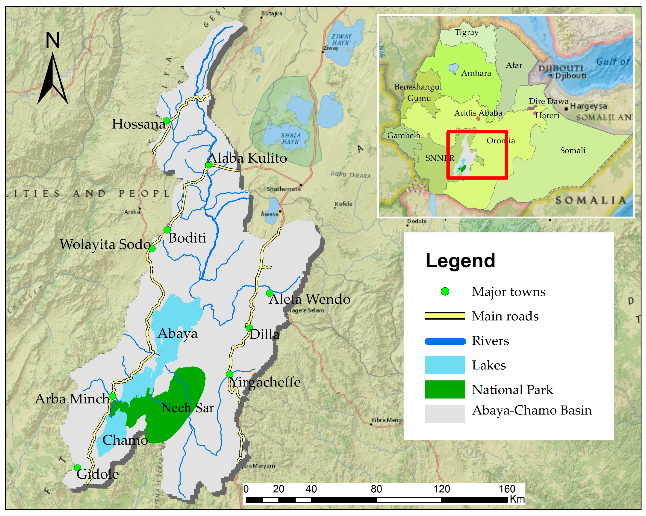
ACB is home to one of the most remarkable aquatic and terrestrial ecosystems of the Main Ethiopian Rift (MER). The basin is known for its diverse plant and animal species composition, and is considered as one of the biodiversity hotspots in Ethiopia [
25]. However, it has been threatened in recent years due to rapid population growth and resettlement, as well as expansion of agricultural and irrigation activities in the landscape [
26,
27,
28]. For the last few decades, an increasing demand for fuelwood and wood for construction, land clearing for agricultural expansion and irrigation activities, and bush burning for pasture have greatly modified the landscape and affected the water quality of lakes found in the basin [
29,
30,
31]. High rates of LULC changes have been reported for the southern part of the basin [
27,
32,
33]. However, none of these studies have sought to map LULC dynamics and quantify landscape pattern changes in time and space for the entire basin and analyze their effects on the landscape in the context of upstream-downstream linkages. As a result, little information exists on the dynamics taking place in the entire landscape of the basin. Previously attempted conservation measures, which have not considered the scope of linkages between changes in the basin as a whole such as the Nech Sar National Park, have suffered from pressure coming from the surrounding areas due to resource degradation and deteriorating agricultural productivity. The measures were also less effective in changing the trend of resource loss on the landscape level and demand costly measures, resulting in conflicts with communities [
34].
There have been a number of studies on the effects of LULC changes on the spatial patterns of the landscape and water quality of lake basins [
4,
23,
35]. Thus, some studies suggested the study of LULC changes as a critical step that should be considered in the environmental protection strategy and sustainable resource management of lake basins. For the ACB, such study is crucial and urgent given the increasing and alarming intensity of anthropogenic activities in the landscape, and the need for implementing environmental protection policies in the basin. Therefore, this study aims to examine the dynamics of LULC in ACB between 1985, 1995, and 2010; to identify the major driving forces of the LULC changes and the consequences associated with these changes; and to quantify landscape metrics in time and space for the entire basin to track changes in the landscape.
4. Discussion
ACB has experienced a substantial and increasing rate of LULC changes and landscape fragmentation over the past 25 years between 1985 and 2010. Both arable land and shrubland were the major LULC classes that account for almost half of the landscape in the first time period between 1985 and 1995. However, the situation changed in the second period between 1995 and 2010, with arable land becoming a major LULC class dominating the landscape of the basin. In both periods, LULC conversions were negligible in mild sub-humid midland and cool and humid highland areas of the basin, despite the presence of high population pressure on the landscape (
Figure S2), indicating that a high population density has less influence on LULC changes of those areas. This is mainly because most suitable land in mild sub-humid midland and cool and humid highland areas was already under arable land, coffee agroforestry, and heterogeneous agriculture, and readily convertible land to new arable uses was in great shortage in these parts of the basin. On the other hand, the high population pressure and shortage of land in those areas compelled the farmers to move into warm semi-arid lowlands of the basin where shrubland, natural grassland, forests, inland wetlands, and inland waters dominate the landscape. The warm semi-arid lowlands of the basin remain a favorite destination for the immigrant farmers (either voluntarily or as part of a government resettlement plan) and, as a result, experienced a greater degree of LULC changes and landscape fragmentation between 1985 and 2010.
The first period was characterized by expansion of arable land, accompanied by a reduction in the natural grassland, and to some extent, shrubland in the landscape of the basin. This was the period when severe drought and famine affected the country, and nationwide planned resettlement and villagization programs were implemented by the government to combat the effects of drought and increase agricultural productivity [
55]. The programs aimed to move farmers from densely populated highlands and drought affected areas into compact settlements in sparsely populated potential areas mostly located in the lowlands [
56]. During the first period, the implementation of resettlement and villagization programs in the basin highly emphasized the problem of food shortage, with little attention to proper impact studies. As in other parts of the country, the outcome of the programs in the basin is often visible through expansion of farmlands by converting areas covered with natural vegetation often more aggressively by newcomers in the process of establishing themselves, with their cultural background that differs from the original inhabitants who have adapted to the system through generations [
57]. For example, the resettlements at Ledo in Guji Zone, Boreda in Gamo Gofa Zone, and Bilate in Wolayita Zone significantly reduced grassland and shrubland covers in those areas. Similarly, the redistribution of communal areas of mostly grasslands to landless farmers and military veterans played a significant role in the reduction of grassland areas in mild sub-humid midland and cool and humid highlands, contributing to the reduction of livestock populations in those areas due to shortage of grazing lands. However, the farmers in these areas heavily rely on enset-coffee system, and the absence of livestock was not a serious threat to their food security and ability to cope with drought and other sources of risks. Similarly, a significant reduction of grassland was observed in the southern part of the basin as a result of a rapid population growth and subsequent conversion of grassland to arable land. Other studies conducted in the southern part of the basin have also documented similar observations. For example, Assefa and Bork [
27] reported a reduction of grassland in the southern part of the basin around Chencha and Arba Minch as a result of rapid population growth and agricultural expansion in the areas. Wagesho [
33] reported a reduction in grassland in Bilate and Hare catchments due to the expansion of settlement and agricultural activities in the landscape. LULC changes due to the effect of resettlement have been documented in other parts of the country as well. Yonas et al. [
58] reported high degradation of rangelands in southwestern Ethiopia following the government resettlement program. Similarly, Reid et al. [
10] reported rapid LULC changes in Ghibe valley, southwestern Ethiopia, caused by the combined effects of resettlement and drought induced migration from some areas of northern Ethiopia.
A relatively large tract of shrubland was removed from the landscape of the basin during the second period between 1995 and 2010. The reduction of shrubland was particularly higher in areas located in the west and south of Lake Chamo and Lake Abaya, mainly due to agricultural expansion in the area. Similarly, shrubland located near urban areas and main roads were reduced due to an increasing demand of wood for fuel and construction by city dwellers. The second period largely corresponds to regime change, followed by social, economic, and political transformation in the country, and the absence of clear land tenure system and weak government during regime change in the country, which created free access to land located in the warm semi-arid lowlands of the basin. Many farmers, particularly from the highlands of Gamo Gofa, Kore and part of Derashe and Guji areas, seized the opportunity and migrated to the area either to find new land to cultivate or generate income from sales of charcoal, firewood, and construction materials to support their livelihoods. As an increasing number of people moved into this part of the basin, the need for more farmland and requirement of wood for fuel and construction increased rapidly, and caused significant reductions of shrubland and expansion of cropland and settlement in the landscape. Additionally, the establishment of new regional boundaries which divide the basin based on ethnicities, and the emergence of new market opportunities for cash crops like banana, cotton, and khat played an additional role for LULC changes in the second period. The expansion of banana and cotton production by both small-scale farmers and commercial farms was one of the main causes for the reduction of shrubland cover in Arba Minch Zuria, Mirab Abaya and Bilate areas. A more recent expansion of infrastructure and irrigation facilities in the basin also contributed to LULC changes in the second period.
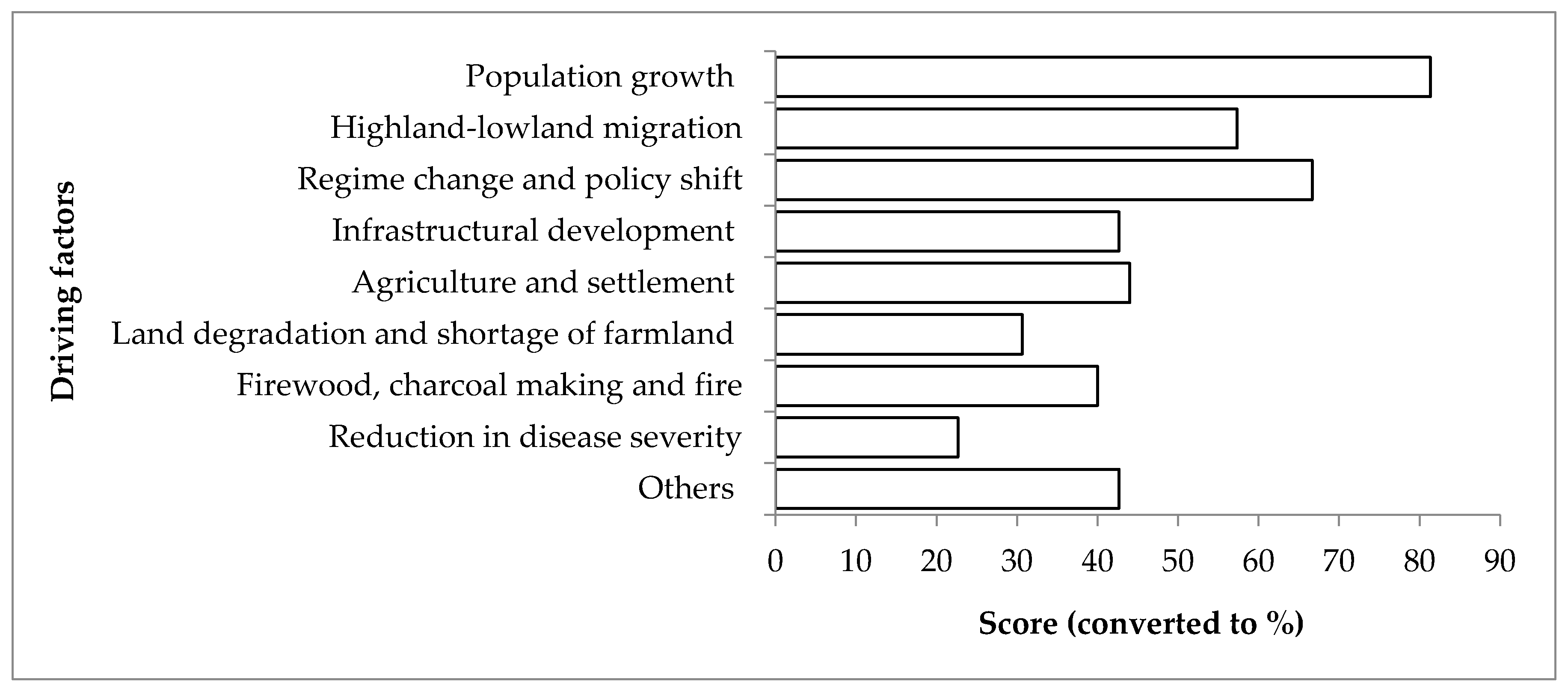
Agricultural expansion related to population growth, migration, shifts in government policy, and regime change is one of the key driving forces behind LULC changes in ACB. Population growth, immigration, and regime change have often been reasons for LULC changes in many parts of the country as well. For example, the government-owned Munesa-Shashemene forestry project lost most of its forest cover to cultivated land during the 1991 government change [
59]. Similarly, Tekle [
60] reported destruction of shrubs and small trees during the same period in Southern Wello in northern Ethiopia. Tsegaye et al. [
58] reported reduction of woodland cover in northern Afar due to a high influx of immigrants from the Tigray highlands following famine in the 1980s.
Rapid population growth as a result of both birth and migration has greatly modified the landscape of ACB. The issues of population growth and a very limited scope to expand agricultural area and/or lack of appropriate technology to improve productivity in the existing area are prominent in the midland and highland areas of the basin. Migration out of areas suffering from land scarcity and low productivity to ecologically marginal areas of the basin, and converting more land to crop cultivation and settlements, are some of the responses of the population. This, additionally driven by infrastructural development and a reduction of vector-borne diseases in the lowlands, has resulted in a reduction and extensive fragmentation of shrublands and natural grasslands located in the warm semi-arid lowland areas of the basin. Due to a higher rate of rural poverty and very few employment opportunities to absorb rural labor, population growth is often correlated with LULC changes in Ethiopia [
61]. This is often the case in other countries in African [
62,
63]. However, population growth does not necessarily result in LULC changes, and environmental degradation in economies that are creating a large number of new jobs in other sectors or land productivity growth can be achieved using agricultural intensification. For example, land abandonment (cropland to grassland) and afforestation (the expansion of forest on cropland and grassland) are reported as the most prominent drivers of landscape change in Europe [
19,
64]. Agricultural intensification contributed to the abandonment and subsequent reforestation of least suitable plots in Vietnam [
65].
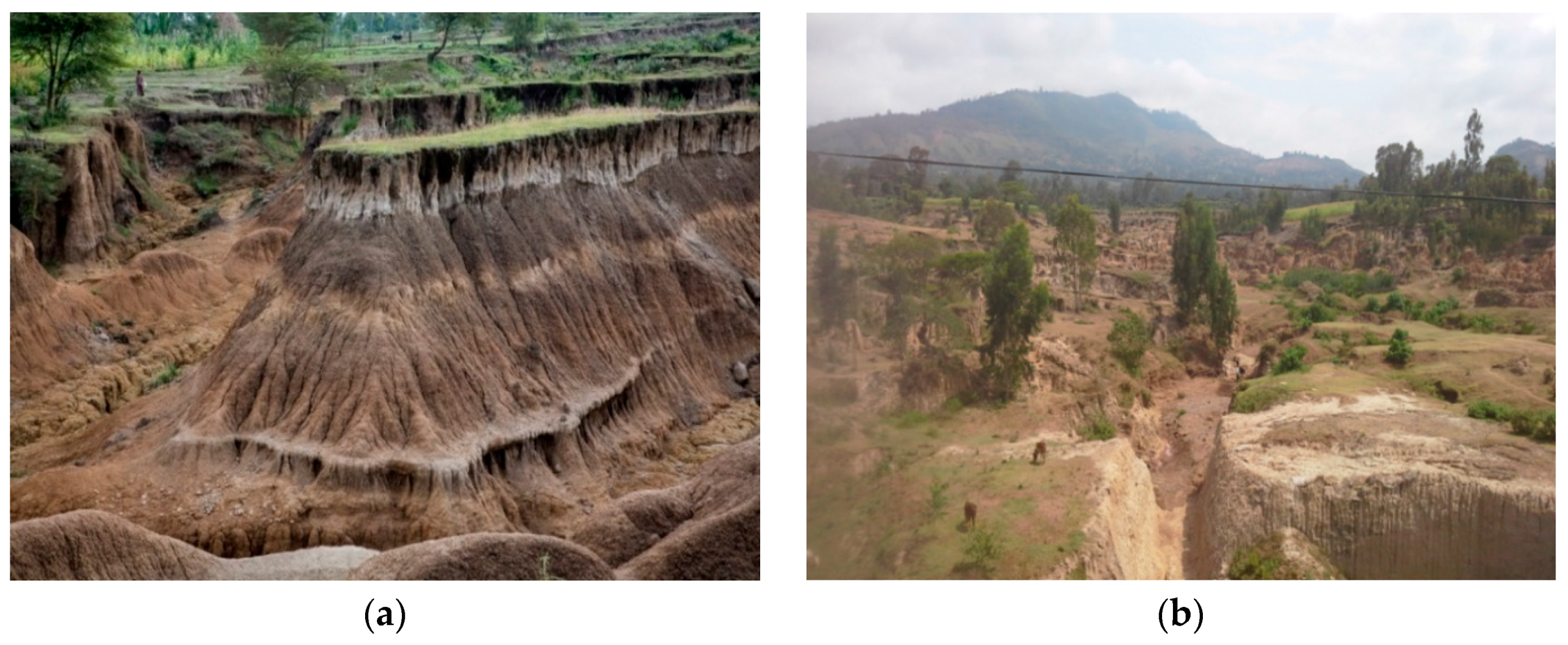
The expansion of agricultural activities in the landscape of ACB at the expense of natural vegetation, and fragmentation of the remaining shrubland and natural grasslands, has great ecological consequences in the basin. Some of the observed consequences of LULC changes in the basin included severe soil erosion and land degradation in mild sub-humid midland and cool and humid highland areas, and increased runoff [
33] and sediment yield [
33,
66,
67] from the catchment to rivers and lakes found in warm semi-arid lowland areas. This is due to reduction of shrubland and natural grassland, which play a significant role in modifying surface hydrology, and soil erosion process and reducing sediment flow in the landscape [
68]. They act as filters or barriers controlling the flows of surface runoff and sediments originated in mild sub-humid and cool and humid highland areas of the basin before it enters rivers, lakes, and wetlands found in the rift floor. The reduction of shrubland and natural grassland covers, and subsequent expansion of cultivated land in the basin, alter this important ecological function and, consequently, affect the volume and water qualities of the lakes found in the rift floor. Fluctuations in the level of Lake Abaya (the biggest lake of the basin) have been observed since the beginning of measurements in the 1970s [
66]. The lake level decreased continually until 1989, and has increased continuously since then, despite annual precipitation in the catchment and major tributaries remaining stagnant or even showing a negative trend [
26,
66]. The result of GIS analysis indicated that the surface area of Lake Abaya reduced by 1.2% in the first period and increased by 2.9% in the second period. The slight reduction of Lake Abaya during the first period was possibly attributed to the effect of severe drought incidences in the 1980s [
66], while the increase in the second period was primarily associated with the effects of LULC changes in the basin. According to Schϋtt and Thiemann [
66], the climatic conditions and geological factors of the basin considered to have less influence on the increasing level of Lake Abaya. LULC changes, on the other hand, were perhaps the most important factor affecting the water level of Lake Abaya. LULC changes have been affecting the water level of the Lake Abaya directly by increasing surface runoff and sediment yield from the catchments, and indirectly by the obstruction of surface outflow from Lake Abaya to Lake Chamo as a result of high sediment deposition in the channel by Kulfo River [
66]. Surface outflow from Lake Abaya to Lake Chamo as a form of overflow is one factor regulating the water level of Lake Abaya. Termination of the overflow of Lake Abaya, and an increased surface runoff from the catchments, helped the lake to store more water and thereby increased its level. Increased runoff and Lake Abaya water levels impacted the size of nearby wetlands. Increased sediment deposition, on the other hand, reduced the storage capacity of the lake and affected its water quality and productivities. Rapid concentration of nutrients, reduced water transparency, the solubility of oxygen, and primary productivity have been observed in the lake [
29,
30,
67]. As a result, the lake has significantly lower fish populations than the neighboring Lake Chamo, despite its size, which is twice as big as the latter lake [
67,
69]. This was also further confirmed by individuals working on both lakes as fishermen during our field visit.
On the contrary, Lake Chamo (the second biggest lake of the basin) has shrunk by 9.3% between 1985 and 2010. High irrigation activities on the tributaries, and the reduction then final termination of Lake Abaya overflow to Lake Chamo, were reported as the main reasons for the reduction of Lake Chamo [
66,
70]. The ongoing shrinkage of Lake Chamo affects the suitable fish breeding grounds and creates an opportunity for farmers to expand their farms and cattle grazing areas into the shoreline and lacustrine plains, which fragmented grazing and basking sites of hippopotamus and other reptiles inhabiting the lake. The negative impacts of these changes are also evident in reduced fish stocks and tourist attraction of the lake.
As arable land continues to expand in warm semi-arid lowland areas of the basin, the landscape experienced a greater degree of fragmentation and formed smaller and isolated patches, mainly comprised of smaller interspersed patches of arable land, shrubland, and natural grassland. The fragmentation of vast areas of shrubland and natural grassland into small and isolated patches may support the claim that ACB is gradually degraded due to increasing human activities in the landscape. Shrubland and natural grassland found in the basin are valuable resources for traditional beekeeping and plants used for medicinal purposes for human and livestock by local communities. They are also important habitats for large mammal and bird species, including those Palaearctic and intra-Africa migrants, as well as those endemic to the country [
71]. The observed continuous destruction and fragmentation of important natural vegetation in the basin reduced the ecological services they provided to the community, as well as greatly affected the role of the landscape for biodiversity conservation. Continuous reduction of habitat patch size and isolation affects composition and diversity of species in the landscape [
72] and the populations of animals that the landscape can support [
73]. This is one of the main factors which contributed to sharp reduction and, in some cases, local extinction of plants and wildlife previously prominent in the area.
5. Conclusions
This study has highlighted and illustrated the process and connotations of a landscape level understanding for sustainable land management planning by taking the case of ACB, which is of vital environmental, social, and economic importance in Ethiopia. LULC changes and simultaneous landscape fragmentation are the main underlying factors for ecosystem change in ACB. The main characteristics of the LULC changes observed in ACB imply a reduction in the total amount of shrubland and natural grassland, and a significant increase in agricultural area. These changes continuously alter the spatial patterns of the landscape, and greatly modify the entire landscape of the basin. The driving factors for the LULC changes in the ACB were both national and regional/ local in origin. Rapid population growth in warm semi-arid areas of the basin as a result of immigration and policy change in the country are considered the most important driving factors for LULC changes in the basin between 1985, 1995, and 2010. Therefore, intervention measures that take into account the socio-political and ecological dynamics of the basin need to be in place in order to streamline the immigration and resettlement processes (either voluntarily or as part of the government plan) into warm semi-arid areas of the basin.
Landscape changes as a result of LULC, and simultaneous landscape pattern changes, are ongoing phenomena in the basin. LULC changes, and the related trend of increasing arable land expansion and reduction of natural vegetation in the basin, may lead to drastic changes in the drainage patterns and water flows. These may alter the vegetation, nutrient levels, and related processes, and damage the aquatic and terrestrial biodiversity of the basin, unless restoration actions are taken soon to save the basin from further damages. Despite its richness in biodiversity, which makes it a rare habitat, and the socioeconomic value ACB has, efforts on the management and restoration plan for conservation and sustainable utilization of its resources are not adequate. This study has achieved a useful milestone to contribute to the development of relevant management approaches for the basin. However, to strengthen the knowledge base, it is recommended that the effect of landscape change on the basin’s biodiversity and resources need be quantified in the future to pinpoint vulnerable species that need urgent conservation attention and introduce sustainable resource management practices in the basin, respectively. At the same time, positive steps should be taken through an innovative approach which combines resource management measures with research. Commitments of the government and concerned NGOs, working closely with local communities through participatory approaches, may facilitate efforts to reverse the current trend of LULC changes in the basin. As the area needs urgent action, sustainable land management approaches should be integrated with the traditional farming and non-farming uses of land in the basin. Combining practical action with research can help practice to be supported with scientific evidence. Therefore, the involvement of research centers and higher education institutions, particularly Arba Minch University, is a good strategy.


