On Landscape Architecture Education and Professional Practice and Their Future Challenges

1
Graduate School of Design, Harvard University, Cambridge, MA 02138, USA
2
Centre for Advanced Spatial Analysis, University College London, London W1T 4TJ, UK
Land 2020, 9(7), 228; https://doi.org/10.3390/land9070228
Submission received: 24 June 2020
/
Revised: 8 July 2020
/
Accepted: 10 July 2020
/
Published: 13 July 2020
(This article belongs to the Special Issue Landscape Architecture Education and Professional Practice and Its Future Challenges in Landscape Design, Planning, Conservation and Management)
Abstract
:Increased environmental and social risk, ubiquitous information technology, and growing demands for and growing threats to democracy and public participation will alter the education and practice of all the design professions and the geographically oriented sciences, and the ways in which their activities towards influencing environmental and social change are organized and carried out. We all know about these trends, but we do not take them seriously enough. We are not adapting fast enough towards education or professional practice that is collaborative and globally oriented.
1. Introduction
When I was initially contacted by the editors of this special issue of Land and asked to contribute a long paper on the theme of “Landscape Architecture Education and Professional Practice and Its Future Challenges in Landscape Design, Planning, Conservation and Management”, my response was that I have thought about and written a lot on this theme in recent years. I suggested that rather than writing something new (given my very busy life in official retirement) I would be happy to selectively edit and adapt some of my previous writing into a long piece on the subject. The editors agreed with the strategy. I therefore am pleased to be able to present my views in a format somewhat different from most journal papers and I very much appreciate the freedom to be able to do so.
2. What Are the Global Trends and Issues Which We Will Face?
We are facing three sets of global trends: increased environmental and social risk, ubiquitous information technology, and growing demands for and growing threats to democracy and public participation [1]. These will increasingly influence the education and practice of the design professions and geographically oriented sciences, and the ways in which their activities towards influencing environmental and social change are organized and carried out. We all know about these trends, but we do not take them seriously enough. We are not adapting fast enough in education or professional practice.
The first is increasing environmental and social risk as seen in Table 1 [2] (Shearer, 2020). While population growth, global temperature rise, the crisis in food production and food price increase, air quality, fresh water, and biodiversity decline are among us, we do not act in a sufficiently coordinated way toward mitigating their serious negative impacts.
The second is ubiquitous information technology. There is a dramatically fast-growing increase in personal computer access to the information of the world. The things we can do with computing are greatly increasing. We interact with computing in ways that are almost like interpersonal relationships. There are lots of examples in which cloud-based data comes from people with cell phones. Immediate available data, for example the radiation levels of the Fukushima nuclear disaster, or the hurricane damage in Haiti and the Philippines, were revealed from the cell phones of ordinary people.
The third is growing demand for, and threats to, democracy and public participation. The political impact of social media is enormous, and the mixture between ubiquitous computing and public participation is not an accident. The spread of information causes the demand for participation in planning for the future. For example, The European Landscape Convention recognizes landscape in law as an essential component of people’s surroundings, and prescribes that each ratifying country establish procedures for the participation of the general public in the definition and implementation of landscape policies. It is extremely important to highlight that the general public must define the landscape policies.
3. What Are the Strategic Alternatives for a School or Profession, Albeit Made by Individuals?
I was one of several people asked to participate in The New Landscape Declaration by The Landscape Foundation, and to write about the future of landscape architecture [3]. I think that there are four reasonably clear possibilities.
The first possibility is simply a continuation of where I think we are today, in which most landscape architecture faculty, students, and professionals are oriented towards immediate, client-oriented projects.
The second possibility assumes increasing competition for what has become “hot property”—the landscape. Architects may increasingly design landscapes as part of what they consider to be architecture; urban designers may increasingly and effectively design landscapes at the middle size; civil engineers, geographers, and ecologists (and politicians, bankers, and lawyers) may increasingly make the significant design decisions at the larger landscape sizes. These trends will increasingly impinge upon education in and practice of landscape architecture. External competition will likely produce a narrower landscape architecture profession, far different from that imagined over 100 years ago by the founders of the profession of landscape architecture and my Department at Harvard University.
The third possibility is perhaps the most likely, and at the same time the most wrongheaded. It is very possible the artificial division between “planning” and “design” will be continued and even reinforced, and that landscape architecture will itself choose to focus on the design of smaller projects, both private and public. In part this may result from successful competition at larger scales from other professions which consider such issues as food and water supply, biodiversity, cultural heritage, population increases, and climate change to be important shapers of landscape. Mainly however, it will result from two factors—society’s unfortunate but common caricature of landscape architecture as closely related to gardening, and the landscape architecture profession’s own professional and accredited academic choices.
The fourth possibility relies on recognizing the wisdom of the founders of the profession. First, we must know something that other professions do not. In our case this must be rooted in the landscape itself and at all sizes and scales: in its climate, geology, hydrology, ecology, vegetation, history, perception, etc. Second, we must learn to understand that almost everything we do to change the landscape by design requires collaboration, whether with architects at the smaller scale, urban designers at the middle scale, geographers at the larger scale, and with engineers at all scales, and layers and bankers and government officials, yet with no one losing his/her professional identity. This was the vision of my department when I joined the faculty in 1964 and it is a perspective which I hold to this day.
We cannot argue that we are the sole bearers of wisdom as it pertains to the land and we cannot argue that we have some self-defined right to be its stewards, to be in charge or even to coordinate. Sometimes we will lead, and sometimes we will not. However, if we are to work on society’s most important needs, both specialist knowledge and skills of collaboration in designing are essential. We must not allow the profession to become limited in the scales and scope of its competences.
I am strongly in favor of this last prospective future, and I hope that it shapes a significant part of the education and practice of future landscape architects and other design professionals.
4. How Can These Issues Best be Approached in Education and Practice?
It is clear that for real and serious societal and environmental issues, designing for change cannot be a solitary activity [4,5]. Rather, it is inevitably a collaborative endeavor, with participants from various design professions and geographic sciences, linked by technology from several locations for rapid communication and feedback, and reliant on transparent communication with the people of the place who are also direct participants. The people of the place are not just the clients; they are the designers as well. Quoting Herbert Simon in his 1978 Nobel Prize lecture, “Everyone designs who devises courses of action aimed at changing existing situations into preferred ones.”
5. On Geodesign
Communication and collaboration among four groups of people is essential to the success of geodesign (Figure 1): design professionals (including architects, planners, civil engineers, landscape architects, and other professionals who deal with innovation), geographic sciences (including ecology, hydrology, geography, and other disciplines which are about how we understand the world), information technologies (involving the ability of people to communicate with each other regardless of the media and not just computers), and the most important, the people of the place [6].
The central point is that we are really facing serious problems which cannot be solved by any single group of people, and communication and collaboration of these four groups is essential. However, our systems of education and practice do yet sufficiently not plan for that. In other words, it is obvious that the collaboration is important, but it is not obvious that education and practice are producing people to do this (Figure 2). We come from different worlds and speak different languages, and we have some fundamental problems which a framework for geodesign may help us overcome.
Geodesign changes geography by design, by intentional change. It is a method which tightly couples the creation of proposals for change with impact simulations informed by geographic contexts and systems thinking (more than form-thinking), and (normally) supported by digital technology. To do this, it proposes the application of a systems-oriented framework for geodesign (mine or another), and to answer six relevant questions that apply to any geodesign circumstance (Figure 3): (1) how should the context be described? (2) How does the context operate? (3) Is the current context working well? (4) How might the context be altered? (5) What differences might the changes cause? Additionally, (6) how should the context be changed?
The geodesign process makes use of diagrams of proposed policies and projects to develop proposed future plans. This technique of using diagrams and their assessments in standardized colors serves as a shared visual language that enables understanding and communication among workshop participants. It enables participants to select from the range of diagrams, and to edit or add new diagrams to create a final negotiated proposal for the study area. The result is not as data-rich as normally recognized in the sciences, nor as detailed as required by the design professions. It is nonetheless extremely useful when confronting a large, complex, and contentious problem (Figure 4). The tools to enable a collaboratively negotiated consensus based on diagrams of policies and projects produce an outcome which indicates only that “ it can be…or might be… something like this”.
Geodesign is an invented word, and a very useful term to describe a collaborative activity that is not the exclusive territory of any design profession, geographic science, or information technology. Each participant must know and be able to contribute something that the others cannot or do not, yet during the process, no one need lose his or her professional, scientific, or personal identity (I do not want anybody to call himself/herself “a geodesigner”, or any design be called “a geodesign”).
6. On Education for the Design Professions
The importance of education is fundamental to progress in geodesign [7]. A revolution in education is required. Right now, most scientists and design professionals believe that students have to know everything in their fields. However, that is very different from educating people to lead collaborative teams. The conflict between depth and breadth is not resolved in the universities, and we do not have the prerequisites of cross-disciplinary communication. We need to have broad shared knowledge, shared assumptions, and shared language. We need to teach and practice many ways of making a geodesign proposal. We need to organize faculties in a collaborative way and based on which types, sizes, and scales of “problem” they are studying [8].
We need four kinds of courses. The most important is history, the history of case studies which work and which did not work. Secondly, we need courses organized by model type not by content type, because the ways of thinking in model types are more important than content which might change geographically. Third, we need to recognize that technology changes rapidly, and it should be taught on a tutorial basis. Finally, we need practical studies with project-oriented learning. Additionally, the projects should be run by students (with supervision) because they are the ones who need experience in organizing and managing studies. Furthermore, I think it is necessary to set up degrees in geodesign—not of Geodesign, but of geography, ecology, architecture, planning, landscape architecture, and other related fields in Geodesign (Figure 5).
The most radical thing we need is a redefinition and restructuring of what a university is. Universities certainly need depth of research, teaching, and application. However, they also need breadth and collaboration. Collaboration in geodesign should be carried out at bachelor’s degree, master’s degree, and PhD degree levels (Figure 6). A typical design-oriented school might have departments of architecture, landscape architecture, and urban planning. The first base of collaboration is in the school. This means the architecture, landscape architecture, and urban planning students should really work together. Most schools have tried this but rarely with success, because they do not have a structure for geodesign-oriented teaching. The next phase is to get other groups, such as scientists, Information Technology (IT) people, and ordinary people into this collaboration. The next phase is at the university level, where there is need to institutionalize creative collaboration. This will take years, but it is absolutely central for success in geodesign and the future of education.
The world needs 10,000 people who can manage geodesign processes and studies. Landscape architects must prominently be among them. These will be among the leaders in helping resolve the very complex and contentious and significant problems which the world will be facing in their own lifetimes.
7. How Can These Longer-Term Global Issues be Confronted in Education?
The vast majority of professional education in Landscape Architecture and other design professions is directed towards training soloists [9,10]. Despite the entry level employment towards which most students initially aim—employment which can be characterized as being neither similar to a soloist nor similar to a conductor—I submit that the majority of students see themselves as becoming soloists. Their goal is to master all of the skills and knowledge needed for effective professional activity—to identify problems, analyze them, plan and design solutions, and see them built to the satisfaction of self, client, and peer. This attitude is not just egocentric. It is a reflection of our system of design education and a central product of that system. In those countries which have professional registration, it is an assumption of and for that recognition.
We are all familiar with the traditional format and structure of studio-based education in which a problem statement is given, students typically work as individuals, and their work is reviewed by expert juries in a somewhat competitive and defensive presentation format. We have all participated in this process as students and as faculty and I suspect that we all have an understanding of the great strengths of this system and some of its weaknesses. Some of the survivors of this teaching method do indeed become highly effective soloists. Many, probably the majority, remain useful “second trombonists” throughout their careers. My purpose is not to attack the traditional studio system upon which most of our schools base their education. Rather, it is to ask another question: “from where will the conductors come?”
Relatively few students see their long-term objectives as preparing themselves for conducting—for being the leaders or managers of teams which collaboratively share an enterprise and the responsibilities for its success or failure. It is my observation that the vast majority of my students have had some teamwork experiences but they have not been clearly organized, and frequently they have not been socially or productively successful. Yet a surprising number of the students whom I have taught are in professional practice as conductors. They are partners and associates in larger firms, often functioning as leaders of project teams. They are in policy-making levels of public agencies. Some of them are teachers. Their professional success is due as much to their critical, judgmental, and managerial skills as it is their actual design and production capabilities. All too frequently they have undergone a difficult and sometimes painful transition between the roles for which they were initially trained and in which they entered the profession, and their current, more responsible roles, and possibly less direct design activities.
I have taught studios on large and complex landscape planning and design problems for more than 40 years at Harvard, and sometimes also with other universities. I have written about my teaching strategies methods, and the framework within which I organize most of my work in other papers. My 1990 framework paper and my 2012 book A Framework for Geodesign were the basis of my Theory and Methods of Landscape Planning course and the structure of all of my many collaborative studios and workshops.
The reasons for my teaching in a manner which requires students to work in teams, and frequently in large, self-managed, multidisciplinary teams, are many but normally center upon the scope and complexity of the problem around which the studio is focused and the need for many individual tasks to be coordinated. Sometimes teams have been as small as three persons, and sometimes they have involved a studio class of 12–18 persons acting as “a team of the whole” to produce a single coordinated design. I would generally characterize these experiences as being successful and positive ones, both from my perspective and those of my students (though I concede that these experiences are not always without pain). Clearly, one of my central purposes is to help educate some future conductors.
I believe that our educational institutions should recognize the difference in education, style, and skill required of conductors versus those demanded of soloists. I certainly believe that we should continue to train soloists; after all, they are essential and the design professions require many more of them. However, I would also argue that no one should escape at least some education directed towards the roles of conductor, not only because there are very many large and crucial landscape-related problems which require team approaches, but also because a lack of exposure to conducting roles can seriously hinder our students’ future professional careers. Simply stated in another way, I am more interested in educating future employers than in training future employees.
8. Geodesign and the Future of Landscape and Urban Planning
In December 2017, I visited Brazil at the invitation of Professor Ana Clara Mourão Moura and with the support of IEAT/UFMG—Institute of Advanced Transdisciplinary Studies, Federal University of Minas Gerais—in the International Visitor Chairs Program. At that time, I met with students, professors, and researchers, and participated in “Geodesign South America 2017”. As part of my activities, an interview was arranged, and it can be watched on the YouTube channel of the Geoprocessing Laboratory from the School of Architecture, Federal University of Minas Gerais [11]. Architect Rafael Lemieszek Pinheiro, representing the group of PhD candidates, conducted the interview. It is selectively edited below.
Rafael—How do you see the planning professions in the present day and what role does geodesign play?
Carl—In my teaching and professional career, which began in the early 1960s, I have seen ebbs and flows in planning, from physical planning to economic planning, to regional planning, to landscape and urban planning and urban design, to administrative planning, to ecological planning, and back toward regional and physical planning. What is interesting is that in some of these periods, the schools were ahead of the professions, and in some of these periods the schools were behind the professions.
Right now, if I look at Europe and North America, South America, and what I have seen in China and India, the schools are a little bit ahead of the professions. And the reason for that is we are in a period in which administrative rulemaking and regulatory approaches are dominant, but often ignored. The schools are recognizing two things: one is that the systems in which these administrators are being trained to work are changing very rapidly. The second thing that they are recognizing is that the amount of urban and landscape change that the world faces in the next 30 years is enormous. The World Bank estimates that we are building the equivalent of a city of a million people every week. The scale of systems change with physical and social consequences is very profound. Some schools are recognizing that we need to educate people to manage these large, complex, and interacting systems which are changing fast. They are changing through entrepreneurial means rather than bureaucratic means. Complexity is greater, diversity is greater, and so the idea that you can manage a city or region through rules is getting less influential. And so, the big question is: how do you manage it? How do you plan for future change?
Multidisciplinary design will be central. Adaptation will be important. Temporary aspects of cities will become more important. And geodesign is in the middle of that, in the sense that it’s not thinking about a city and an urban environment like a building, and it’s not treating it like a science: it’s a design problem, a mixture of those. And there is a very powerful consequence of that. Normally, in both practice and in education, we are more focused on producing specialists. However, 60 years ago, planners were more like generalists: they had to know a lot about a little, as opposed to a little about a lot. And what we’re now beginning to see, largely through geodesign—but not only through that—is a greater attention to multidisciplinary ways of thinking and practicing. And we are beginning to again produce more generalists, because I think we need them. We need 10,000 people who are more generalist than specialist, we need them in the next 10 years, and the universities are the only place where they can come from. But their practice will be different from the practice of specialists who know their specialty but don’t work very well with the next specialty.
And these are very profound changes and very healthy ones, and the work that I am trying to do is in the middle of that. Because I consider myself a generalist. I have my specialties, but I can talk to lots of people. And my students are trained not to make one design by one student, but to make one design from 15 students, and to manage, participate in, and understand how you can apply a geodesign process.
So, I find it a big challenge and in the last 10 years I have been teaching teachers, mainly because they were not educated to produce generalists. The faculties around the world are much too focused on specialists, and I think that this is important but it’s not enough; it’s not enough to solve the very difficult problems that the world faces.
Rafael—On the same topic: as you know, we have no landscape planning courses in Brazil...
Carl—I think that is terrible. It’s stupid and it’s terrible because your country is going to be destroyed by the landscape being destroyed. If your landscape is destroyed, your water system is destroyed, if your water system is destroyed, urban life will be destroyed… I have a late close friend, Dick Toth, and he said “If the landscape is wrong, it’s all wrong.”
Rafael—You mentioned there is this division between entrepreneurial activities and bureaucratic activities and geodesign. How do you see that: is there a middle ground?
Carl—I think negotiation is important. The idea of negotiation as a design method is not the tradition of design. The norm is “This design is my design”, as opposed to “…our design”. When you are thinking of a region or a large part of a city, nobody knows enough. There is no one profession that knows enough, so it has to be collaborative, it has to be multidisciplinary, it has to be negotiated. Furthermore, the people that you are designing for when you’re designing for 30 years maybe not be alive yet, and the people who are there now may be dead…. so how do you negotiate among multiple clients who think they know what they want, but who are going to be in a greatly changing environment during their lifetimes, and certainly in the next generation’s lifetimes? None of us knows the exact answer for that, so we have to figure ways of designing that are robust, resilient, flexible, adaptable, rather than grandly conceptual and personal. That is not being done sufficiently in practice, and it is also not being done sufficiently in the schools. It is being done in some, but not in the majority of schools.
In my career I have been in more than 175 universities. Almost all of them are schools of design: architecture, urban planning, urban design, and landscape architecture. They are all relatively similar, as they all usually teach studios based on a site, a client, and a program of change requirements, and normally each student designs a project. And I am interested in teaching students on a different basis: they don’t know who the clients are (or there are several groups and they have conflicting objectives), the site is huge, and there are a large number of component projects …. And 12–15 students need to design one project, staged over a long time…. so, it’s much more diffuse, much more complex, and I think much more challenging. And I am most interested in how do you even think about it and how the design process begins at the strategic level. And in this I am influenced by the teachers that I had 60 years ago, and mainly my mentor, Kevin Lynch [12] (Figure 7).
Rafael—I think geodesign can probably play a very important part on that: geodesign tools, like Geodesignhub [13].
Carl—The tools make it easier to be more democratic and more equitable, but they don’t guarantee behavior. People have to understand that. The ideology may claim to be more equitable and more democratic, and the tools may support that by making negotiation easier, but that doesn’t mean that human behavior is equitable and fair and democratic. People that I know are trying to do geodesign in tyrannical governments and it is very difficult. And I know people who are working in corrupt governments, and it is very frustrating …but those things change also, and I hope for the better.
Rafael—In your Brazilian experience, what are some of the obstacles you see to overcome to achieve territorial planning?
Carl—The obstacles are probably in three different realms. One is overpopulation and under-income. The destruction of Amazonia is the obvious one that the world is very much aware of. But it’s also government not enforcing laws that it has. And I think the schools are to blame as well, because the schools are still in a pipeline of specialties. You have an architecture school here, and I imagine that they’re very good at having their students designing buildings, and very bad at having them designing all of Minas Gerais. And yet, they think professionally that the architect is responsible for designing Minas Gerais. And I think that that’s outrageous and fundamentally arrogant. Now the question that follows from that is: why should geodesign it be in the architecture school? Why shouldn’t it be in the agronomy, and the civil engineering, and the hydrology, and the ecology, and the sociology, and the architecture school? And taught as a collaboration across the university? I’ve advised several universities along those lines.
Rafael—Do you think is rather a question of making the current courses more multidisciplinary?
Carl—Not all of them. Working on projects inside the university that require multidisciplinary work, and in which the students and the faculties teach each other what they know, so that the students have a broad experience in a project that needs to have a solution …this needs a new model of teaching. My book “A Framework for Geodesign” was conceived based on my teaching experience and directly for this need. I would never hesitate to give such a challenging problem to 30 students from across the university, and have 10 faculty members, each presenting their own perspectives as professors of ecology, hydrology, mining, housing, economy and history, for example…as opposed to only architecture or landscape architecture or planning. They would all learn a lot. Those students would have a very different experience, and that does not mean that they shouldn’t have a specialty, also. But not just a specialty.
Rafael—So, you think geodesign is an important tool for redistributing power?
Carl—It can be, but, again, it doesn’t guarantee it. Methods and tools can be misused. They can be used for public good, but they also can be used for public bad. If you tell me what design you want, I know that I can maneuver the tools to give you your design. But that’s true of any design method or tool, so geodesign is not different in that sense. On the other hand, the ideas which surround geodesign, which people are promoting, are basically based on the diagram that I designed for the cover of my book: the people, the sciences, the design professions, and the information technology working together. The people are part of that process, and they should be the most important part of that.
Rafael—One of the problems is the problem of jurisdiction. The urban areas often move across city lines, state lines, sometimes country lines...
Carl—Absolutely, that’s right. This is not a new problem: it’s the history of adjusting governmental responsibility and civic responsibility to meet the geography and the systems that have to be managed. If you have a water system that goes across state lines, they have to be coordinated. If it’s all in one watershed, you can’t have one state flooding another state without repercussions: it has to be managed as a single system related to the scale that it operates on.
Most countries have planning and implementation responsibilities which are based on local political jurisdictions. But real planning in the future is not going to be that way. It will be based on multiple, integrated, system-based geographical boundaries such as watersheds and metropolitan transport districts. With future cities of 20, 30, or 40 million people, it is absurd to run everything at local levels. Some systems should be regionally managed, some systems should be locally decided.
Rafael—From your experience, it’s obvious that geodesign tools are very important for opening up processes for people to have to say. Is there any kind of precaution, or any kind of measures that should be taken to keep these processes from being taken over by specific interests? Is there any way to manipulate people using “open” processes?
Carl—The answer is yes. If you’re inclined to manipulate people, the tool can allow you to do that, and I fully understand that. But, from experience that we’ve had so far, most of the people that are using geodesign ideas and tools are involving ordinary people in the design of very complicated situations, as opposed to making a design professionally and then just showing it to people for approval or disapproval. They are trying to redefine the concept of what public participation is. There are short-comings: when we do a project, we might have 30 people, 30 out of 30 million, and that it still raises the question of “Who are the people who are participating?”, “How did you pick them?”, “Are they random?”, “Is it crowdsourced?”, “What are their roles?”. There are all kinds of very serious problems. But you have to compare those problems against the problems of not doing it that way, and you’ll see that it’s probably an improvement, or at least I hope it’s an improvement [13,14,15,16].
I must say that so far, GeodesignHub as one group of tools—because there are other fine sets of tools—has been applied in about 200 projects, and I don’t think any of them have been a failure. Nobody is gone away really angry. And that’s pretty good. If you had 200 plans you would normally have a lot of angry people, and we haven’t. And if we ask people—and we have, almost always—“Do you feel that you’ve had your voice in this process?” And they say: “Not all on everything, but enough, and we’re satisfied.” …because the end product is a negotiation, and they’re part of that process. It’s not that I’m imposing my design or your design on these people; it’s a very different psychological aspect of being part of a design process. This approach has been robust and appreciated [17,18].
So far geodesign is very promising movement, with a set of seemingly useful ideas and tools, and there are an increasing number of people interested, which I’m very happy about. For example, see the web site of the International Geodesign Collaboration (IGC) [19], of which I was a co-founder in 2018 and am co-coordinator. The IGC’s 2020 book [18] presents and comparatively assesses geodesign studies made in the first year by more than 50 global universities (among 90+ participating schools) working in an agreed structure but on their own local studies (Figure 8). In the first year, more than 1100 people participated in IGC studies.
Rafael—My experience with participatory processes in general—when there are criticisms, and there often are—they’re usually either that the process is not open enough, or that it is too open. If it is not open enough you can’t do certain things, you’re restricted to a certain kind of interaction. And sometimes it is too open and it doesn’t engage people, people can’t relate to it because it’s too open...
Carl—My view of the world’s public participation processes is that they’re mostly not effective, and sometimes purposefully so. And there’s one reason: because in most cases they are run as a meeting in which one person speaks at a time, unless they’re yelling at each other. The tools that we’re designing for geodesign are quiet, and everybody’s working, so that they’re talking in terms of the substance of the policies and projects, which are the basis of the design. And it’s a much more civilized process, because everyone in the workshop is making a design for their own objectives, and then they have to figure out a way to make something come out the other end that usually is one design. And there’s no one person dominating the discussion, which is very purposeful in the way we work with the tools. So, if you come in and join us, you’re immediately put to work. You’re listening to a small number of diverse people working toward a single objective, and then you have to merge your objectives and your designs. I think that’s very useful.
Rafael—A very important part of the geodesign processes seems to be the gathering and processing of information that is going to serve as the basis of maps for the actual processes. When you have a very short time to work on very large-scale projects, you have to have data that is reliable, that you can trust.
Carl—My view is this: if you if you know why you’re doing the study, and you’ve answered the “Why” questions in my framework, you have to go to the “How we are going to work?” questions. It’s very important for you to define that the 10 or so systems that you’re going to be dealing with. And then go up the framework questions and eventually you’ll say “What are the data that we need to do the studies that we need to do” to get to an answer. And at that point, my view is to get the minimum data, not the maximum data. And I have almost always found an ability to find public data sources. I’ve had some difficulty in some countries where data is secret, but in general I’ve never found a real problem in acquiring the data that I would need to do the beginning strategic stages of a very complicated design. And I really believe that data needs to be collected only when you have a purpose and use for it. So, I have no patience whatsoever with simple data collection. I think it’s too often an undirected waste of time, energy and money.
Rafael—When you are looking at a data you are looking at the past. Do you think geodesign is a way of people collaborating and imagining new futures together?
Carl—I think this is not just imagining new futures. Those futures are in part rooted upon their experience and data, and driven by their hopes for something different and better. In my view, its main purpose is to change the trajectory that many people feel of things going badly, and so if you are modeling something that’s going badly, you have to change the fundamental systems and their managed synthesis over time. That is the central design problem for geodesign. The generic problem is: how do we organize and conduct the very beginning and strategic stages of designing for longer-term change in a large, multi-system, multi-client and contentious context.….and one which should not become a zero-sum game? This is very frequently the normal situation for proposing solutions for important and complex projects and studies.
Rafael—It’s more about proposing than understanding?
Carl—It’s both. It’s definitely about proposing based on your understanding, but it’s also broadening your experience of understanding and the data. It’s a human process supported by data and human intelligence… and not a data management process manipulated by humans or “artificial intelligence”.
Rafael—That’s very important.
Carl—It is very important, I agree.
Rafael—We talked a little bit about the institutional aspect of planning, of how it should be integrated. What do you think that means for the professionals in planning?
Carl—I have a very long-term answer to that. If you’re a university student, you should know a lot about a little and a little about a lot, but not just a lot about a little or just a little about a lot. Therefore, I think that you can’t have education without time. The people who start in-depth and then move across disciplines are fine, and the people who start broadly and then discover that they want to become specialists are also fine. But the people who only become specialists in one discipline, are not going to be as effective in geodesign. One of them might win the Nobel Prize, but they won’t be the Minister of Environment.
I believe you need to know something that somebody else doesn’t, but enough to talk to lots of people in different fields. The people who are going to be influential (or even survive) professionally, in changing professional environments, are not the people who are experts in one piece of software, or in one detail of how to plant trees, or in one material. It’s not going to be that way, because the professions are going to change much more rapidly, and they have to be adaptable and adapt.
Rafael—I’d like to thank you very much—unfortunately, we don’t have the rest of the day to keep talking about all of this...
Carl—I’ve enjoyed this very much. I think you’ve asked me some very good, profound, difficult questions. Thank you.
Funding
This research received no external funding.
Conflicts of Interest
The author declares no conflict of interest.
References
- Steinitz, C. Trends and Influences, and their implication for Practice and Education in Geodesign. Landsc. Archit. Front. 2013, 79–82. [Google Scholar]
- Shearer, A. Design Assumptions. In The International Geodesign Collaboration: Changing Geography by Design; Fisher, T., Orland, B., Steinitz, C., Eds.; Esri Press: Redlands, CA, USA, 2020; pp. 11–18. [Google Scholar]
- Steinitz, C. On the Future of Landscape Architecture. In The New Landscape Declaration; The Landscape Foundation, Ed.; Rare Bird Books: Los Angeles, CA, USA; pp. 105–110. Available online: https://www.lafoundation.org/resources/2016/07/declaration-carl-steinitz (accessed on 13 July 2020).
- Steinitz, C. A Framework for Theory Applicable to the Education of Landscape Architects (and other Environmental Design Professionals). Landsc. J. 1990, 9, 136–143. [Google Scholar] [CrossRef]
- Hollstein, L.M. Retrospective and reconsideration: The first 25 years of the Steinitz framework for landscape architecture education and environmental design. Landsc. Urban Plan. 2019, 186, 56–66. [Google Scholar] [CrossRef]
- Steinitz, C. A Framework for Geodesign; Esri Press: Redlands, CA, USA, 2012; pp. 7–23. [Google Scholar]
- Steinitz, C. On change and geodesign. Landsc. Urban Plan. 2016, 156, 23–25. [Google Scholar] [CrossRef]
- Steinitz, C. Teaching in Geodesign. 2020. Available online: https://www.youtube.com/watch?v=Vcj7qk0cgG4&list=PLaPDDLTCmy4bRZVzAhDunzOscHg0ghn6Q&index=4&t=0s (accessed on 13 July 2020).
- Steinitz, C. Teaching in a collaborative studio context: On educating conductors and “getting started”. In Teaching Landscape: The Studio Experience; Jorgensen, K., Karadeniz, N., Mertens, E., Stiles, R., Eds.; Routledge: Abingdon, UK, 2019; pp. 122–135. [Google Scholar]
- Steinitz, C. Matters of scale. Landsc. Archit. 2010, 100, 206–208. [Google Scholar]
- Steinitz, C.; Pinheiro, R. Interview: Geodesign and the future of landscape and urban planning. Disenarecon 2018, 11. Available online: http://disegnarecon.univaq.it/ojs/index.php/disegnarecon/article/view/389 (accessed on 13 July 2020).
- Lynch, K. A Theory of Urban Form; MIT Press: Cambridge, MA, USA, 1981; p. 50. [Google Scholar]
- Ballal, H. Geodesign Hub. Available online: https://www.geodesignhub.com/ (accessed on 17 January 2020).
- Ballal, H.; Steinitz, C. A Workshop in Geodesign Synthesis. In Digital Landscape Architecture; Buhmann, E., Ervin, S., Pietsch, P., Eds.; Herbert Wichmann Press: Aachen, Germany, 2015; pp. 400–407. [Google Scholar]
- Steinitz, C. Geodesign Negotiation and Four Case Studies. Available online: https://youtu.be/QERJbL9J1Xw (accessed on 17 January 2020).
- Steinitz, C. Beginnings of Geodesign. In Geo-Design: Advances in Bridging Geo-information Technology, Urban Planning and Landscape Architecture; Nijhuis, S., Zlatanova, S., Dias, E., van der Hoeven, F., van der Spek, S., Eds.; Delft University of Technology: Delft, The Netherlands, 2017; pp. 9–24. [Google Scholar]
- Orland, B.; Steinitz, C. Improving our Global Infrastructure: The International Geodesign Collaboration. J. Digit. Landsc. Archit. 2019, 4, 213–221. [Google Scholar]
- Fisher, T.; Orland, B.; Steinitz, C. The International Geodesign Collaboration: Changing Geography by Design; Esri Press: Redlands, CA, USA, 2020. [Google Scholar]
- International Geodesign Collaboration. Available online: http://www.igc-geodesign.org (accessed on 17 January 2020).
Figure 1.
The communication and collaboration of the four groups is essential to the success of geodesign, with figures color coded by the four groups.
Figure 1.
The communication and collaboration of the four groups is essential to the success of geodesign, with figures color coded by the four groups.
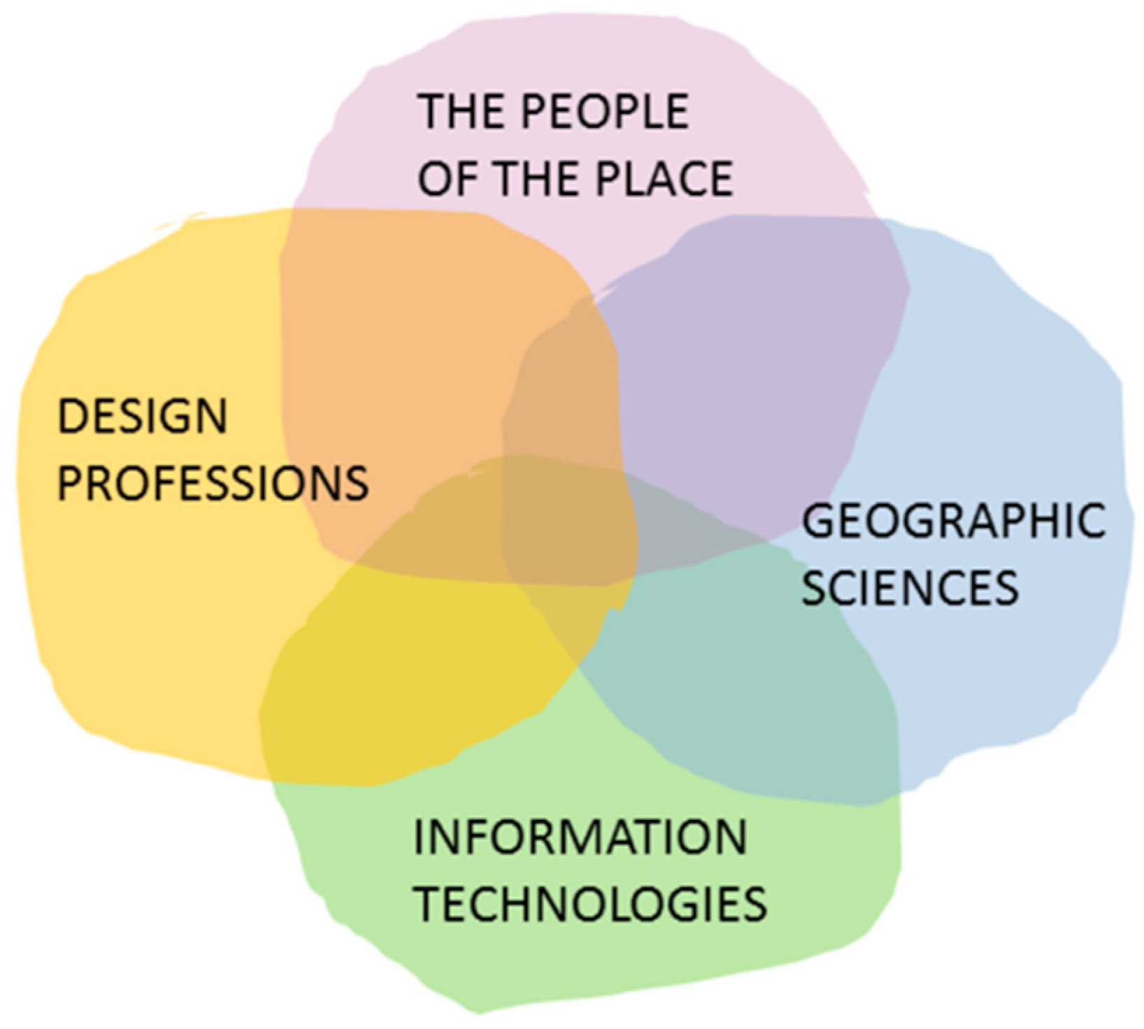
Figure 2.
This is where I think collaboration in geodesign can be most effective.

Figure 3.
Six questions need to be answered for any geodesign circumstance.

Figure 4.
Geodesign ideas can come from anyone while in a collaboration.

Figure 5.
Teaching for collaboration in geodesign.

Figure 6.
A university with collaboration in geodesign.

Figure 7.
Kevin Lynch, Requirements for Normative Theory [11] (p. 50).
Figure 7.
Kevin Lynch, Requirements for Normative Theory [11] (p. 50).

Figure 8.
The International Geodesign Collaboration: Changing Geography by Design [17].
Figure 8.
The International Geodesign Collaboration: Changing Geography by Design [17].


Table 1.
Global assumptions for 2050 [2].
Table 1.
Global assumptions for 2050 [2].
| Global Assumption | Descriptor |
|---|---|
| Global 1 | Population will continue to grow |
| Global 2 | Populations will grow older |
| Global 3 | Populations will be concentrated in urban areas |
| Global 4 | The global economy will double, fastest in emerging markets |
| Global 5 | Supply and distribution of energy will be transformed |
| Global 6 | Transportation will become more automated |
| Global 7 | The built environment will be more networked and “smarter” |
| Global 8 | Global temperature will rise, climate variability will increase |
| Global 9 | Sea levels will rise |
| Global 10 | Freshwater scarcity will become more prevalent |
| Global 11 | Food production pressures will increase |
| Global 12 | Population concerns will intensify |
© 2020 by the author. Licensee MDPI, Basel, Switzerland. This article is an open access article distributed under the terms and conditions of the Creative Commons Attribution (CC BY) license (http://creativecommons.org/licenses/by/4.0/).
Share and Cite
MDPI and ACS Style
Steinitz, C. On Landscape Architecture Education and Professional Practice and Their Future Challenges. Land 2020, 9, 228. https://doi.org/10.3390/land9070228
AMA Style
Steinitz C. On Landscape Architecture Education and Professional Practice and Their Future Challenges. Land. 2020; 9(7):228. https://doi.org/10.3390/land9070228
Chicago/Turabian StyleSteinitz, Carl. 2020. "On Landscape Architecture Education and Professional Practice and Their Future Challenges" Land 9, no. 7: 228. https://doi.org/10.3390/land9070228
Note that from the first issue of 2016, this journal uses article numbers instead of page numbers. See further details here.