Article

Natural and Anthropogenic Origin of Metals in Lacustrine Sediments; Assessment and Consequences—A Case Study of Wigry Lake (Poland)

1
Department of Environmental Protection, Faculty of Geology, Geophysics and Environmental Protection, AGH University of Science and Technology, Al. Mickiewicza 30, 30-059 Kraków, Poland
2
Department of Geoinformatics and Applied Computer Science, Faculty of Geology, Geophysics and Environmental Protection, AGH University of Science and Technology, Al. Mickiewicza 30, 30-059 Kraków, Poland
*
Author to whom correspondence should be addressed.
Minerals 2021, 11(2), 158; https://doi.org/10.3390/min11020158
Submission received: 30 December 2020 / Revised: 26 January 2021 / Accepted: 31 January 2021 / Published: 3 February 2021
(This article belongs to the Special Issue Elemental Concentration and Pollution in Soil, Water, and Sediment)

Abstract

:
The contamination of aquatic sediments by metals is a worldwide phenomenon and its assessment is a fairly complex issue, as numerous factors affect the distribution of particular contaminants in the environment, as well as their bioavailability. Wigry Lake, as the object of this study, is almost a perfect water body for such considerations. It has been well investigated and densely sampled (up to 459 sediment samples). The quantities of seven metals were determined using the atomic absorption spectrometry (AAS) or inductively coupled plasma (ICP)-MS methods, following previous extraction in a microwave oven. The levels of concentration of the examined elements were as follows (min–max (mg·kg−1)): Cd—0.003–3.060; Cr—0.20–22.61; Cu—0.02–59.70; Fe—80–32,857; Mn—18–1698; Pb—7.0–107.5; Zn—3.1–632.1. Significant differences were also registered in terms of particular metal concentrations in different sediment types found at the lake bottom. Five different geochemical backgrounds and sediment quality guidelines implemented in the study enabled a very scrupulous contamination assessment of the lake sediments’ condition, as well as the evaluation of the natural and anthropogenic contribution to the enrichment of examined sediments in metals. Although Wigry Lake is situated in a pristine region, it is still subject to anthropopressure, which seems to be the lowest in respect to Cr and Mn, while the highest in the case of Pb. The chemoecological state of the lake was ultimately assessed as good. The study highlighted the necessity of an integrated approach to the assessment of contamination or pollution in the course of an environmental research.

1. Introduction

Metals are native elements, which can be found in the earth’s crust, but environmental contamination or pollution is generally connected with anthropogenic activity, such as mining and smelting, agriculture, industry (especially energy production and distribution, plastic, textile, microelectronic, and wood industries) or sewage effluents [1]. Some metals (such as Co, Cu, Cr, Fe, Mg, Mn, Mo, Ni, Se, Zn) are essential for living organisms, playing the role of microelements, but become toxic while applied in higher doses [2,3]. Others seem to be neutral, or their biological role is unknown, while some elements (e.g., Hg, Pb) are considered biologically useless and harmful in all concentrations [3,4,5]. It is also worth noting that the biological role of some metals, previously considered only harmful, has now been recognized. An example of such an element is cadmium [6].
The term “heavy metals”, although commonly used in science, is ambiguous, as it is defined in terms of different properties, such as density, atomic number, or relative atomic mass [7,8,9,10]. In environmental sciences, heavy metals are identified as toxic, ecotoxic, or hazardous elements, including some metalloids as well, e.g., arsenic. This term is also often used synonymously with “trace metals” or “trace elements” [8,9,11,12,13]. Ali and Khan [10] recently proposed a new definition of the term “heavy metals” as ‘naturally occurring metals having an atomic number (Z) greater than 20 and an elemental density greater than 5 g·cm−3’; however, this “semantic problem” still seems to be unresolved. The authors therefore decided to avoid the term ”heavy metals”, using instead some more neutral forms, such as metals, elements, or simply their names, as suggested by Chapman and Holzmann [14].
Soil and water environments are particularly susceptible to the accumulation of metals [3]. In aquatic environments, metals dissolved in water (as the most assimilable for living organisms) are usually quickly removed through sorption (physical, chemical, or ion exchange-based) on solid particles of suspended matter, or by precipitation and bonding in the structure of minerals. Finally, such elements are accumulated in sediments, thus becoming much less hazardous, but they may be, however, released again in the event of unfavorable environmental conditions [15,16,17,18,19]. The accumulation of metals in aquatic sediments depends on many variables, e.g., the geological character of the catchment and its development, or morphometric and hydrologic characteristics of a particular water body. One of the key factors is the chemical and granular composition of deposits [15], wherein the most important contributors, which facilitate the accumulation of metals in aquatic deposits, are: organic matter, clays, Fe/Mn oxides, sulfides [20,21,22,23,24], and the small size of sediment particles [25,26,27,28]. All of these factors also affect the bioavailability of hazardous substances bonded in the sediment matrix, including metals. Bioavailability is further dependent on physiochemical conditions (pH, redox gradient, salinity, water hardness, temperature), chemical and physical speciation of metals, some processes that may take place within the sediment (resuspension, deposition, pore water convection), route of exposure, and finally on the properties of living organisms exposed to harmful chemicals [29,30,31,32,33,34,35]. The most important factors, which influence the bioavailability of metals, are the potential of hydrogen (pH) and the redox potential (Eh) [35].
As the presence of metals in aquatic sediments may be considered quasi-persistent, research on their concentration in that component may be a good indicator of the chemoecological state of the particular water body, as well as of the historical contamination or pollution. There are many indicators and criteria for the assessment of the condition of sediments, which are used around the world. One of the first, and nowadays widely used indicators, is the geoaccumulation index (Igeo), defined by Müller [36]. Some other subsequently proposed indicators include, e.g., the contamination factor (Cf) and the degree of contamination (Cd) [37] or enrichment factor (EF), primarily used in order to speculate on the origin of some elements in the atmosphere, e.g., [38,39], but further adopted for soils, e.g., [40,41], sediments, e.g., [42,43], rainwater, e.g., [44,45], bioindicators, e.g., [46], and other environmental components [47]. Most of the indicators used in contamination or pollution assessment refer to some background values; therefore, the establishment and appropriate definition of the geochemical background seems to be a crucial, but also a complicated issue [48]. Background values, understood as concentrations of particular chemicals or elements naturally present in the environment, may be determined in many ways [28,47,48,49,50,51,52,53,54,55]. Some researchers tend to compare their data with some “globally” defined geochemical background, proposed, e.g., by Turekian and Wedephol [56], Håkanson [37], or Taylor and McLennan [57], while others consider that any geochemical background values should be determined locally. The main role of a geochemical background in environmental research is to determine whether the studied area is anthropogenically affected and whether we are dealing with the effect of contamination or pollution. Contamination of a particular environment, by some chemical, means that concentration of that substance is elevated when compared to the background value, whereas when adverse effects on biota occur, the environment is considered polluted [58]. The geochemical background does not provide any information on the influence of a given substance or element on living organisms. Therefore, sediment quality guidelines (SQGs), which define certain critical threshold concentration values of selected chemicals associated with specifically determined effects of biota, were provided. These include: threshold effect level (TEL; concentration below which adverse effects are expected to occur only rarely) and probable effect level (PEL; the concentration above which adverse effects are expected to occur frequently) proposed by Smith et al. [59]. Those limit values were further adjusted by MacDonald et al. [60] and proposed as threshold effect concentration (TEC) and probable effect concentration (PEC).
Considering all of the above, Wigry Lake seems to be a perfect water body for the analysis of environmental assessment issues, as it has been very well investigated in many aspects, densely sampled and geochemically examined in terms of 7 metals: Cd, Cr, Cu, Fe, Mn, Pb, and Zn. This article summarizes more than a decade of research conducted on this lake and focuses on the concentration of metals in sediments. The main issues of the article are as follows: (1) the description of the spatial distribution of metals in Wigry Lake sediments in a geochemical and environmental context; and (2) the assessment of contamination and evaluation of natural and anthropogenic contribution to the enrichment of recent Wigry sediments in metals.

2. Materials and Methods

2.1. Study Area

Wigry (located in north-eastern Poland, at the area of Suwałki Lakeland—Figure 1) is one of the most valuable Polish lakes, discovered for science only in the second half of the 19th century [61]. Nevertheless, the lake, as well as its vicinity, quickly became an object of interest for researchers from many fields of science and many papers were published during the next century [62,63,64,65,66,67,68,69,70,71,72,73], including even Slavonic studies [74]. In 1998, Wigry Lake, as the first in the world, was “adopted” by the International Association of Theoretical and Applied Limnology [75]. More “contemporary” research on Wigry Lake started in 1997, as a result of the passion and commitment of Professor Jacek Rutkowski, professionally associated with the Polish Geological Society, the Polish Limnological Society, and the AGH University of Science and Technology [76], in cooperation with the authorities and personnel of the Wigry National Park, as well as other scientists. During more than two decades that followed, numerous studies were published in many fields, such as hydrobiology [77,78,79,80,81,82,83,84,85,86], paleoclimatology, paleolimnology, isotopic investigations and dating [87,88,89,90,91,92,93,94], limnology and sedimentology [95,96,97,98,99,100,101,102], and finally geochemistry and environmental contamination, also with metals [103,104,105,106,107,108,109,110,111,112,113,114], which is further discussed in more detail.
Wigry is a postglacial lake, typical of northern Poland, but it differs from other water bodies in this region due to its interesting and complicated morphology with a diversified coastline pattern, numerous islands, and shallows. The lake was finally formed during Weichselian (Vistulian, Baltic) glaciation and may be divided into five main parts, characterized by diverse bathymetry and a slightly different origin (of a furrow or morainic type), which are usually separated by distinct shallows and narrowings of the lake basin (Figure 1b). Wigry is also one of the biggest (water area: 21.2 km2; islands area: 0.68 km2; capacity: 336.7 mln m3) and the deepest (maximum depth: 73 m; mean depth: 15.8 m) lakes in Poland. Wigry is fed and drained mainly by waters of the Czarna Hańcza River, which flows through the northern part of the lake. Other elements of the Wigry Lake water system include several smaller lakes nearby, streams, springs, and precipitations [94,101,111]. Sediments of Wigry Lake have been extensively investigated and represent several types of deposits, but with the vast majority being carbonate sediments. Profundal (60–75% of the lake’s bottom) sediments, as the most homogeneous in this regard, are represented by carbonate gyttja (CaCO3: 54–87%; organic matter: 8–30%; silt fraction: 95–99%), while littoral sediments are more diverse. The most typical deposit present in the shallow parts of the lake is lacustrine chalk (CaCO3: 52–98%; organic matter: 2–7%; silt fraction: 41–72%). Other littoral deposits, which are found only locally, include clastic sediment, i.e., sands and gravels (CaCO3: 7–16%; organic matter: <1%; silt fraction: <1%), and organic gyttja, a specific variety of which is fluvial-lacustrine sediment present in the mouth of the Czarna Hańcza River (CaCO3: 3–14%; organic matter: 10–51%; silt fraction: not determined) [95,97,98,101,102,103,107,110,114].

2.2. Sampling and Laboratory Research

Wigry Lake sediments were sampled during summer stagnation periods during more than ten successive years (starting from 1997), ultimately resulting in the collection of over 1200 sediment cores of up to 1.5 m in length. Samples were collected from a motorboat using a gravitational sampler, designed and constructed specifically for this research [115]. Sampling point locations were determined by GPS and their depths by echo-sounder (model 381/382 by FURUNO Electronic Company, Nagasaki, Japan) or using a multi-parameter water quality monitor (model 6920 by YSI Inc., Yellow Springs, OH, USA), sometimes also using a calibrated pole (in the shallows). Adequately secured cores were then transported to the laboratory of the Wigry National Park (Krzywe, Poland), sliced into subsamples and subject to further analysis, including lithological and geochemical studies. For the purposes of metal concentration analysis, the top 0–5 cm of the cores was separated and dried and further analysis was conducted in the laboratory of the AGH University of Science and Technology (Kraków, Poland). Homogenized samples were treated with a mixture of 10 mL of 65% HNO3 (POCH, Poland) and 2 mL of 30% H2O2 (Chempur, Poland) and digested in a microwave oven (model MDS 2000 by CEM Corporation, Charlotte, NC, USA). The extracted metals were determined using atomic absorption spectrometry (AAS—model SP9 by PYE UNICAM, Cambridge, UK; Fe: limit of quantification (LOQ)—60 μg·L−1, Mn: LOQ—27 μg·L−1, Pb: LOQ—10 μg·L−1 and Zn: LOQ—1 μg·L−1) or using an inductively coupled plasma induced mass spectrometer (ICP-MS—model HP 4500 by Hewlett-Packard, Palo Alto, CA, USA; Cd: LOQ—0.16 μg·L−1, Cr: LOQ—0.21 μg·L−1 and Cu: LOQ—0.23 μg·L−1). In order to ensure high analytical quality, reagents were of the highest purity, reagent blanks were used, and reference material (LKSD-4) was analyzed, additionally, using inductively coupled plasma atomic emission spectrometry (ICP-AES—model Plasma 40 by Perkin-Elmer, Wellesley, MA, USA) (Table 1). The quality of the results was evaluated through the analysis of variance by the Robust statistics method [116,117] and estimated as very good.

2.3. Data Processing

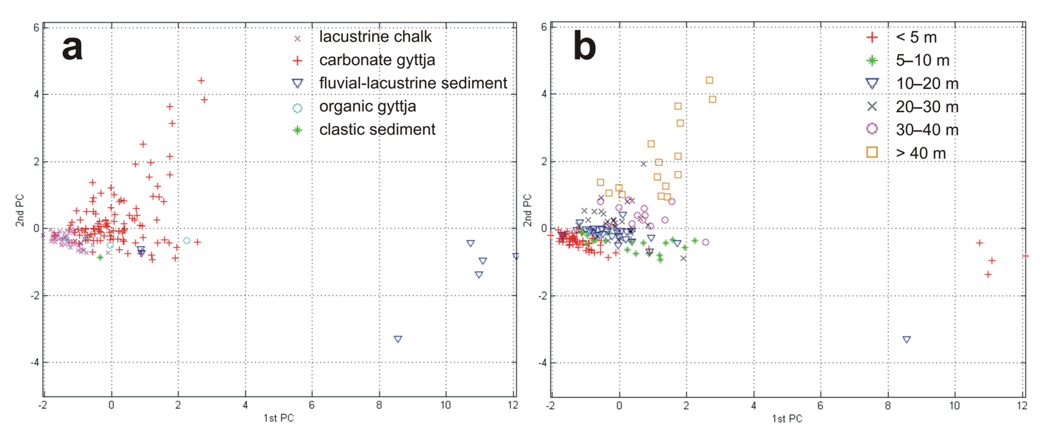
Metal concentrations were determined ultimately for 162 (in case of Pb) to 459 (in case of Fe) samples (Table 2), which gave a sampling density from about 8 to 22 per km2, respectively. All samples were identified in terms of belonging to one of five deposit types that can be found at the Wigry Lake bottom, i.e., lacustrine chalk, carbonate gyttja, fluvial-lacustrine sediment, organic gyttja, and clastic sediment (characterized briefly above). Basic statistical parameters were calculated with the use of STATISTICA software (ver. 13.3, TIBCO Software Inc., Palo Alto, CA, USA) both for particular sediment types and for all samples collectively (Table 2). The data was also statistically analyzed using principal component analysis (PCA), in order to investigate the multivariate relationship between the concentrations of metals and the type of sediments and the depth. Lead was excluded from analysis, as its concentration values were in the majority determined on a separate samples set from other metals. The PCA was therefore carried out on the basis of samples containing information on the type of sediment, depth and the concentration of other elements, i.e., Cd, Cr, Cu, Fe, Mn, and Zn, excluding those with incomplete data. This ultimately resulted in a set of 177 samples taken for PCA, which was carried out with a use of MATLAB software (ver. 8.2.0.701 (R2013b), The MathWorks Inc., Natick, MA, USA) (Figure 2).
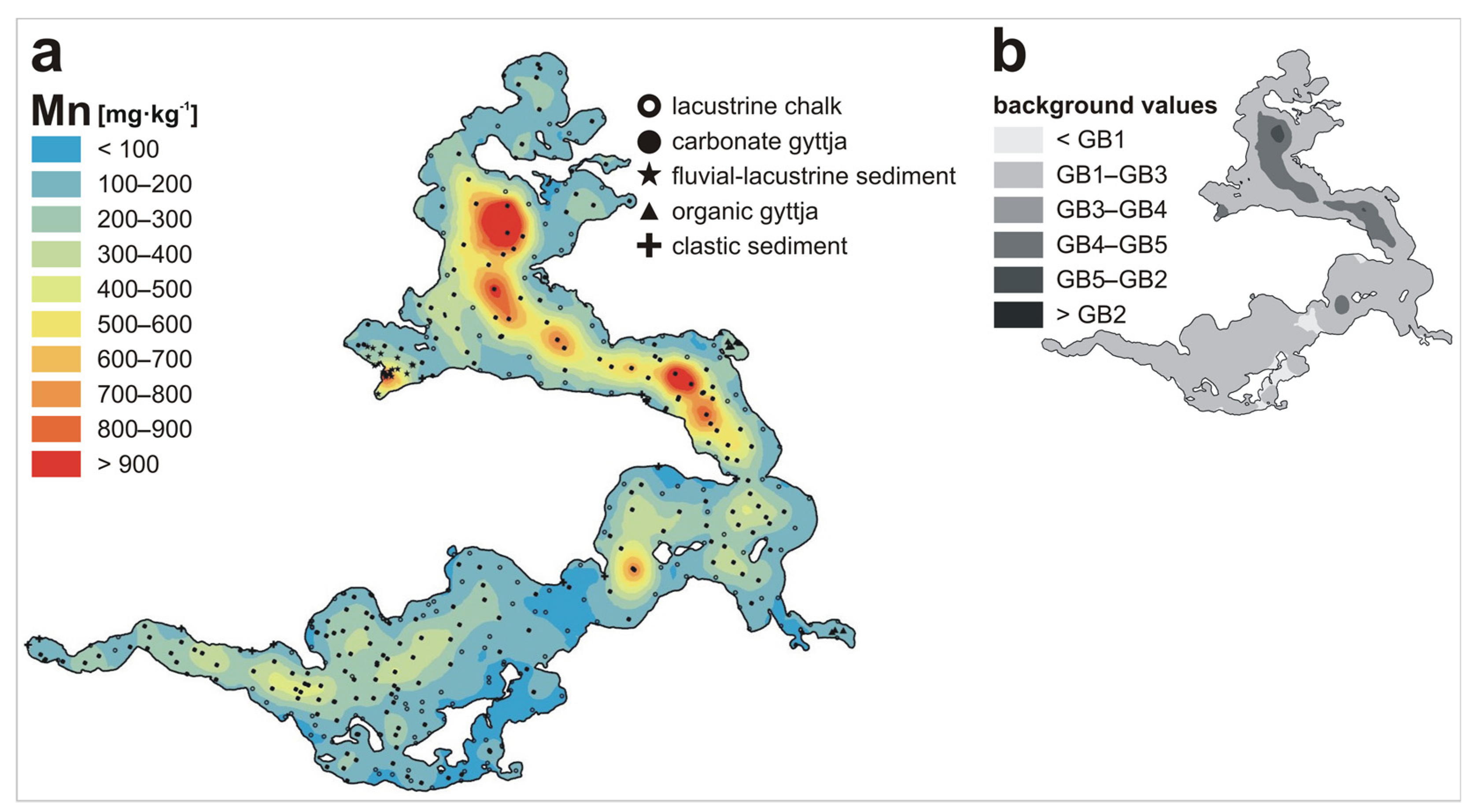
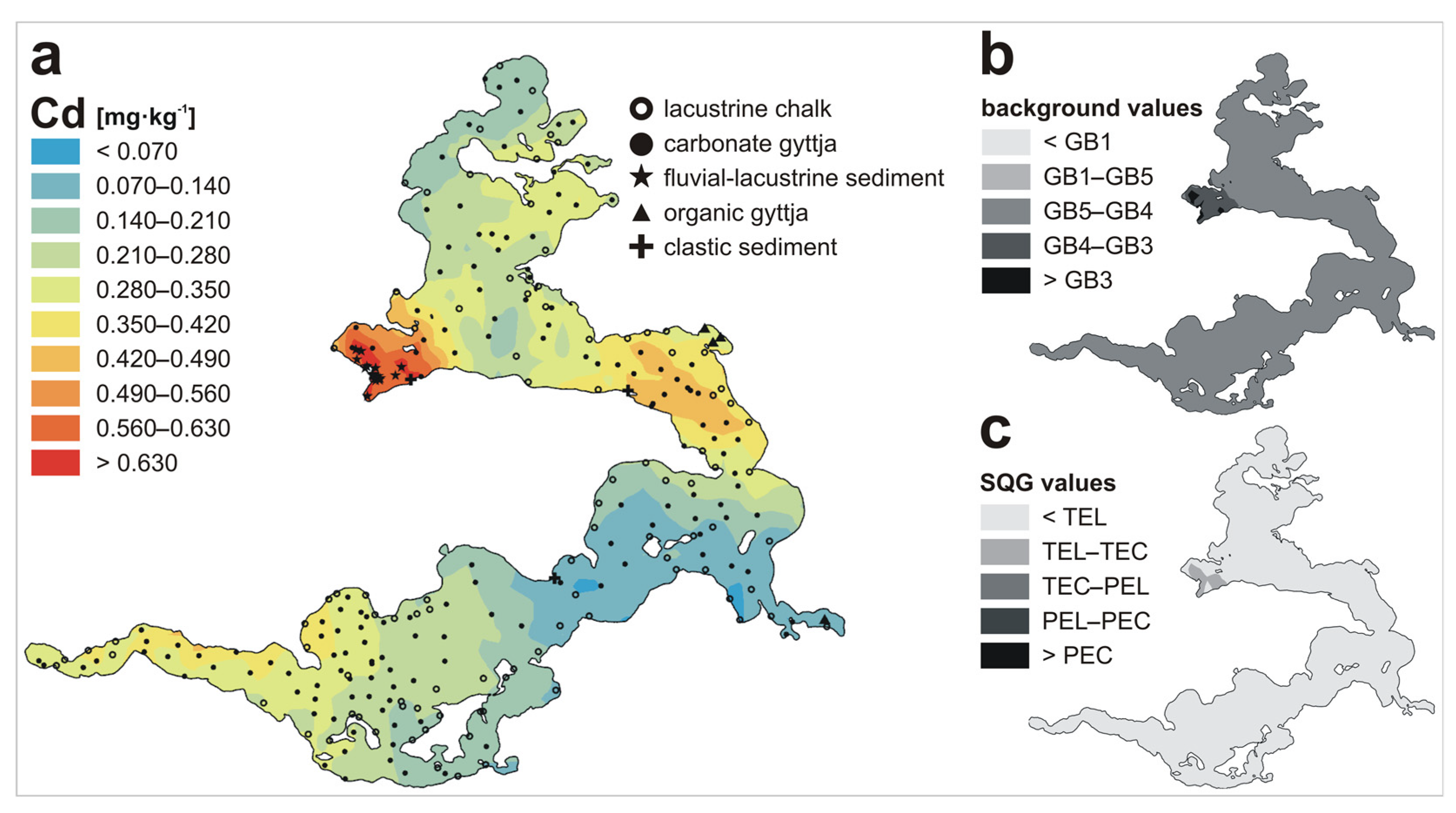
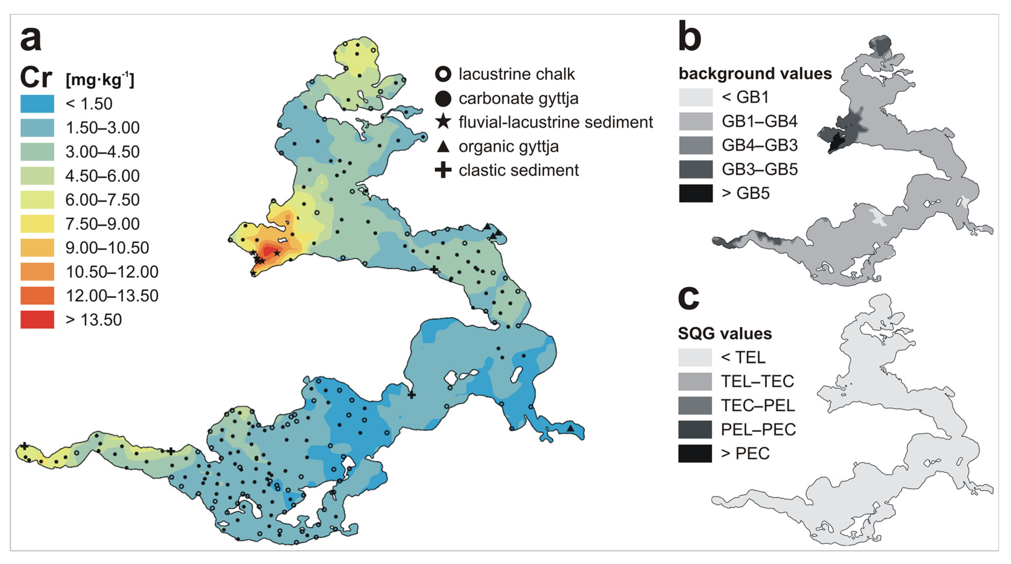
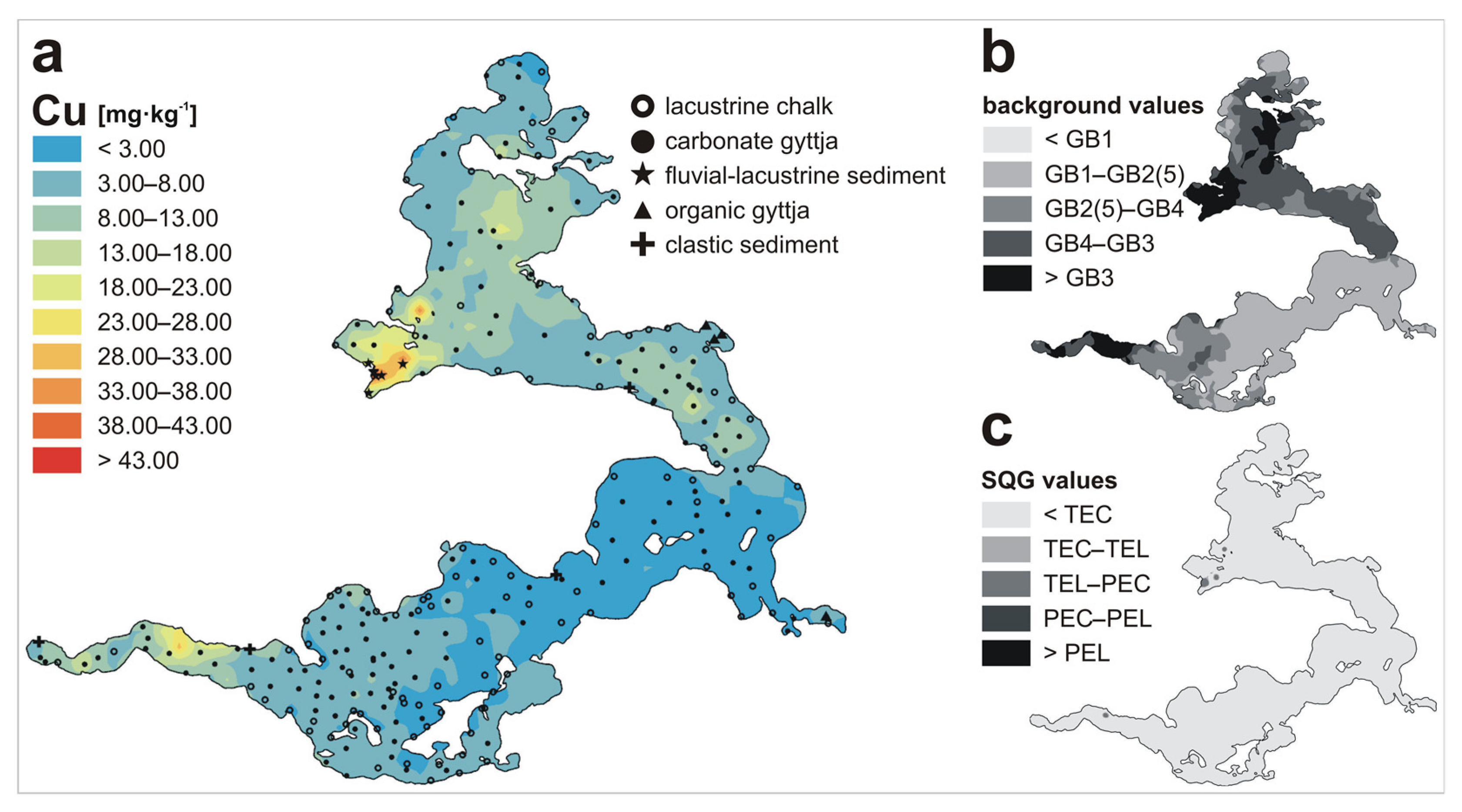
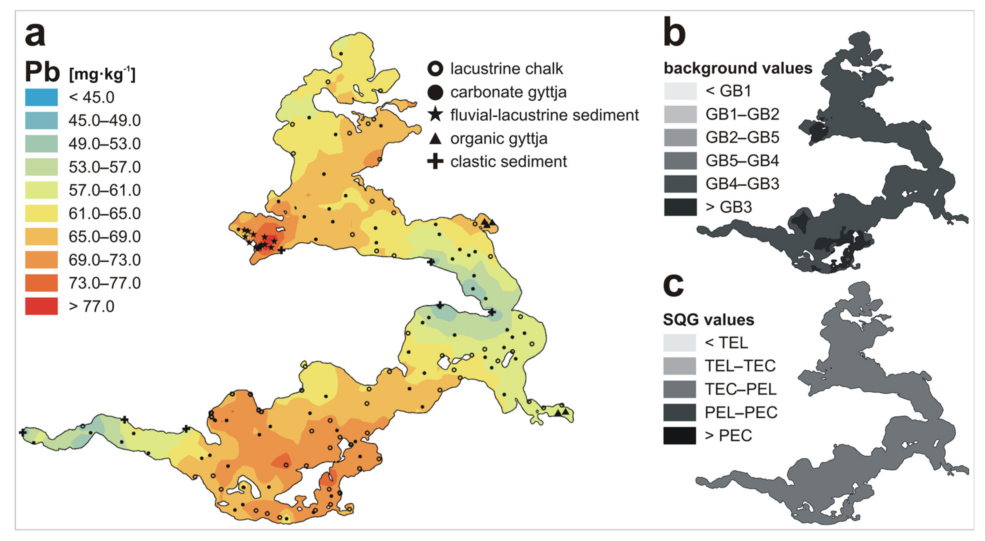
All maps were prepared with the use of the ArcGIS Pro software (ver. 2.6.3, ESRI Inc., Redlands, CA, USA). The bathymetry map (Figure 1c) and the maps of metal spatial distribution (Figures 3a–9a) were created using an ordinary kriging procedure [119], which gave the best interpolation results for the presented data and which has been described in more detail previously [113,114]. The bathymetry map was based on depth data received during ”contemporary” Wigry Lake research (after 1997), while collecting sediment samples, and gathered during the performance of seismoacoustic studies [96,99,100]. Similarly, maps of spatial distribution of metals were based on data gathered for over a decade, starting from 1997. Maps presenting Wigry Lake sediments mapped on the basis of geochemical backgrounds (Figures 3b–9b) and sediment quality guidelines (Figures 5c–9c) were based on particular metal spatial distribution maps (Figures 3a–9a) and appropriate threshold values (Table 3). In the case of GB3, upper range limits were considered for analysis.

3. Results and Discussion

Characteristic of the Wigry Lake is the fact that particular types of its sediments differ significantly in terms of their metal concentrations, and these differences (as mean values) can even be several dozen-fold (Table 2). The least enriched with the analyzed elements is lacustrine chalk (for Cd, Cr, Cu, and Fe) or clastic sediment (for Mn, Pb, and Zn), while the richest in metals is fluvial-lacustrine sediment. This observation has been emphasized in previous studies concerning the Wigry Lake [103,106,111,112], but gathered and summarized in detail only recently [113,114], which was possible due to the availability of an abundant data set.
Two types of sediments covering almost the whole bottom of the lake, i.e., carbonate gyttja and lacustrine chalk, represent nearly perfect examples of the influence of two important contributors favoring metals accumulation in aquatic environments, i.e., granular composition of sediment particles [15,25,26,27,28] and chemical composition of deposits [15,20,21,22,23,24]. Both of them, carbonate gyttja and lacustrine chalk, are composed mainly of silt and clay fraction, but in the case of chalk sandy and even gravel fraction may also be observed [95]; this type of deposit is then relatively coarse-grained. That is the main reason why metals are less likely to accumulate in lacustrine chalk, which has been confirmed also by some specific, detailed studies. For example, calcium carbonate, which makes up lacustrine chalk, is partly precipitated with the participation of Charophyta (a group of algae), which leads to the formation of calcite tubes of even more than 1 cm in length, and it was found that those tubes are made of almost pure CaCO3 [98]. Moreover, research on pore water mineralization of Wigry Lake sediments has revealed that it is relatively low in the case of lacustrine chalk (544.5 mg/L) when compared to other types of deposits (e.g., carbonate gyttja—717.7 mg/L; fluvial-lacustrine sediment—1670.9 mg/L) [120]. Consequently, apart from lacustrine chalk, clastic sediment, as the most coarse-grained, is also the least enriched with metals. The granularity of sediment particles also explains the correlation of concentration of elements with the depth of the lake, which has been found significant for Fe (Figure 1c and Figure 3a), Zn (Figure 1c and Figure 8a), and especially for Mn (Figure 1c and Figure 4a) [111,113]. The reason for that is the tendency of fine-grained sediments to accumulate in deeper areas of the lake bottom [15].
In the context of the chemical composition of Wigry Lake sediments, it has been found that the accumulation of metals is mostly facilitated by the presence of organic matter, as it acts as a sorbent for metals primarily via the formation of complexes [20,34]. Organic matter in aquatic environments comes mostly from decay of plant and animal material and is usually present in the form of humic substances. As to the sorption of metals, the most important are fine particles (of a silt and clay fraction), due to the relatively larger interaction area of a unit amount of material made up of particles with a smaller diameter. This kind of organic material comes mainly from benthic invertebrate fecal material, biofilms, and decay of aquatic macrophytes [21,34,121,122,123,124]. Profundal sediment—carbonate gyttja—is more organic-rich and metals-rich than littoral lacustrine chalk or clastic sediment. Other deposits found on low depths, such as organic gyttja, and especially fluvial-lacustrine sediment, are rich in metals when compared to lacustrine chalk or clastic sediment (Table 2), which is mainly due to their relatively high organic matter content. Metal concentrations (except for Fe) in organic gyttja are comparable with those recorded for carbonate gyttja, which is related to the specific conditions in which organic gyttja is formed. This type of sediment can be found in Cieszkinajki Bay and Krzyżańska Bay (Figure 1b), which are quite isolated from the main lake basin. This is a factor that restricts water circulation and favors eutrophication, and a symptom of that phenomenon is the reduction of CaCO3 precipitation and the displacement of carbonate sediments by organic ones [98]. Finally, the most organic-rich fluvial-lacustrine sediment found at the mouth of the Czarna Hańcza River (Figure 1b) is the richest in all examined metals (Table 2, Figure 3a, Figure 4a, Figure 5a, Figure 6a, Figure 7a, Figure 8a and Figure 9a).
All of the above was also confirmed by the results of the principal component analysis (PCA), which revealed that the two largest variances in the data set, related to the PC1 and PC2 axes, together explain 87.5% of the variability of data set. PC1 explains 64.5% of the data variability (Figure 2a) and it coincides well with the type of sediment. PC2 explains 23.0% of the variability (Figure 2b) and is correlated to the depth of sediments. Most of the fluvial-lacustrine sediment samples form a separate cluster with high values on the PC1 axis. The remaining data show the greatest variability in the intermediate direction between PC1 and PC2, and form clusters, but less apparent. The highest values in this direction are found in the case of carbonate gyttja samples, while the smallest ones are in the case of lacustrine chalk (Figure 2a). In Figure 2b, characteristic data variability in a direction close to the PC2 axis may be observed. Samples taken from the shallows have the lowest values, while samples taken from the depths—the highest. Manganese stands out here from other metals used in PCA analysis (i.e., Cd, Cr, Cu, Fe, and Zn), as its relationship with PC1 and PC2 axes is comparable, which means that this element is the least related to the sediment type (in comparison to other metals), but the most related to the depth, which is further discussed.
The assessment of the chemoecological state of the Wigry Lake is a very interesting issue, as very extensively investigated lake sediments, abundant data set, and as many as five different geochemical background values, which could be applied in this study, allowed for a very scrupulous analysis. In this paper, the authors decided not to demonstrate some of the very commonly used indices, e.g., contamination factor (Cf), degree of contamination (Cd) [37], or the pollution load index (PLI) [125], because they have been calculated and discussed in detail before [114], for five of the seven metals presented here (Cd, Cr, Cu, Pb, and Zn), and values calculated additionally for Fe and Mn would not add anything new. The other widely used indicator—the geoaccumulation index (Igeo) [36]—could not be used in this study, as the index formula refers to metal concentrations in pelitic sediment fraction [126], while bulk samples have been examined in the case of Wigry Lake. Moreover, all mentioned indices are based on geochemical backgrounds; therefore, their values are strongly affected by the background values used, and those might be diversified. This was shown before [114], where the obtained assessment results for the condition of Wigry Lake sediments ranged from “uncontaminated” to “extremely polluted”, depending on background values adopted for calculations. In this paper, therefore, we focus only on background values themselves. Three of them are local, while the other two are more globally defined.
The first of the local geochemical backgrounds (GB1) was established on the basis of results obtained for five lacustrine chalk samples, taken from the vicinity of the contemporary Wigry Lake and underlying peat dated with 14C method at 7970 ± 70 years BP [103,127]. The second one (GB2) was implemented as a range of metal concentration values obtained for the bottom layer of five core samples taken from the basin of the Wigry Lake. The cores were dated and their bottom layers are known to originate from the preindustrial period [104]. The third local geochemical background (GB3) is a fairly new idea and was implemented for the first time in the case of Wigry Lake only recently [114], in accordance with the concept of Matschullat et al. [48]. The method proposed by authors assumes that the concentrations of a particulate substance naturally present in the environment should demonstrate normal distribution, and any abnormal values (usually associated with contamination or pollution) lead to the right-skewness of the distribution function. A threshold value calculated using the method called a “calculated distribution function” is defined as the median plus 2σ, where σ is the standard deviation of a normal distribution estimated on the basis of data lower than the median. GB3, defined previously for Cd, Cr, Cu, Pb, and Zn [114], could be calculated only for carbonate gyttja samples, as in case of other sediment types, data sets were too small or the method assumptions were not met. Then, consequently, GB3 for Fe and Mn was calculated here also on the basis of carbonate gyttja samples.
The next geochemical background (GB4) was adopted from the Geochemical Atlas of Poland [128], as mean values of metal concentrations in 993 sediment samples taken from various aquatic environments (e.g., rivers, streams, channels, lakes, reservoirs, ponds) in Poland. The last one—the world geochemical background (GB5)—was defined as mean concentrations of elements in carbonate rocks, according to Turekian and Wedephol [56], as carbonate sedimentation predominates in the Wigry Lake basin. All presented background values (gathered in Table 3) have advantages and disadvantages, which have been listed before [114]. Briefly, GB1 and GB2 were calculated on quite a small number of samples. Moreover, GB1 refers to lacustrine chalk, covering only up to 30% of the current lake bottom, but on the other hand, this type of sediment was dominant in the paleo-lake [93,101]. GB3 in turn refers only to carbonate gyttja, but this type of sediment covers the majority of the current lake bottom. GB4 (as based on aquatic samples of different origin and chemical and granular composition) and GB5 (as based on carbonate rocks of different origin and not being aquatic sediments) seem to be too “general”. It is also worth noting that GB1–GB5 values are very divergent, differing even by several orders of magnitude. Generally, the lowest values for all metals are in the case of GB1, while the highest in the case of GB3 (for Cd, Cu, Pb, and Zn), GB2 (for Fe and Mn), or GB5 (for Cr). Nevertheless, implementing so many different geochemical backgrounds, along with the critical approach to their informative value, gives a fairly reasonable base for assessment of the chemoecological state of Wigry Lake sediments, which has been visualized on the maps (Figure 3b, Figure 4b, Figure 5b, Figure 6b, Figure 7b, Figure 8b and Figure 9b).
The quality of Wigry Lake sediments was also based on sediment quality guidelines, which define certain critical concentrations associated with specifically defined effects on biota, proposed by Smith et al. [59]. The guidelines determine two threshold values: the threshold effect level (TEL) and the probable effect level (PEL) adjusted by MacDonald et al. [60] and renamed to threshold effect concentration (TEC) and probable effect concentration (PEC). These two threshold values give three ranges of possible effects on biota. Below the TEL/TEC (minimal effect range)—adverse effects are expected to occur only rarely; between the TEL/TEC and PEL/PEC (possible effect range)—adverse effects may occasionally occur; above the PEL/PEC (probable effect range)—adverse effects occur frequently. It is notable that both the TEL and TEC, as well as PEL and PEC values, do not differ significantly, and all of these threshold concentrations (listed in Table 3) were implemented in the course of the present study. SQGs were used previously to assess the quality of Wigry Lake sediments [114], however here they are visualized in the form of maps for Cd, Cr, Cu, Pb, and Zn (Figure 5c, Figure 6c, Figure 7c, Figure 8c and Figure 9c); there are no values of SQGs for Fe and Mn. It should also be remembered that SQGs have some limitations too. For example, false positive assessment results (if SQGs indicate that a sediment is toxic when in fact it is not) and false negative assessment results (when SQGs suggest that a sediment is nontoxic, but, in fact, it is toxic) may occur. Moreover, SQGs do not take into account the bioavailable fraction of contaminants [58], which is known to be affected by many factors [29,30,31,32,33,34,35]. Nevertheless, the application of SQGs values, along with five different geochemical backgrounds, provides a solid basis for the assessment of the chemoecological state of Wigry Lake sediments. Particular metals, which display similar characteristics or significance, are analyzed further together, in order to make the discussion more clear and concise.
Spatial distribution of iron (Figure 3a) and manganese (Figure 4a) in Wigry Lake sediments, as well as the results of principal component analysis (discussed above) (Figure 2), and the coefficients of correlation between the concentrations of these metals, and the depth of the lake (0.77 and 0.60, respectively) [113] indicate that both elements have fairly similar geochemistry and, likely, origin (at least to some extent). Manganese and iron are both redox-sensitive elements [129,130] and tend to coexist in the form of oxides and hydroxides [131]. Their correlation with depth may be explained by sediment diagenesis, during which Fe and Mn undergo selective dissolution and migration in pore waters in an upwards direction [15]. This leads to the constant enrichment of the upper layer of sediments with these metals, which is the highest in the deepest parts of the lake, with the thickest layer of deposits, as has been discussed more closely before [113]. The mean values of concentrations of both of these metals are the highest in fluvial-lacustrine sediment. However, maximum amounts of Mn have been observed in the case of carbonate gyttja samples located in the deepest part of the lake—the Szyja Basin (Figure 1b,c and Figure 4a), while maximum concentrations of Fe can be found in the mouth of the Czarna Hańcza River (Figure 1b and Figure 3a). This phenomenon may be explained by specific conditions present in the area of the mixing of Czarna Hańcza River and Wigry Lake waters, where water flow parameters and physio-chemical parameters are subject to rapid changes, which favors the precipitation of any contaminants carried out by the river [108]. A similar phenomenon was observed for example in the case of other Polish lake [27]. This observation is in line with the study on the ecological state of the Wigry National Park water system [104], as well as with the research on phosphorus concentrations and precipitation in the lake environment [132,133]. Moreover, it is known that iron and phosphorus have a tendency to coprecipitate [134]. Manganese, on the other hand, is oxidized more slowly [135,136] and can be transported over longer distances. This is in line with results obtained from the PCA analysis, which revealed that among all examined metals, Mn was the most strongly related to the PC2 axis, corresponding with the lake depth. Both metals may originate from the weathering of post-glacial rock fragments (rich in these elements), mainly igneous and metamorphic. In the petrographic composition of gravels found in the Wigry Lake and its vicinity, crystalline rocks (originating mainly from Scandinavia) constitute about 45%, which is typical for northern Poland [98,137].
High concentrations of both Fe and Mn in ground waters in the area of the Wigry National Park [73,111] also suggest a mostly natural origin of these metals in lake sediments. The geochemical background values are also notable. Figures presenting Wigry Lake sediments mapped according to five different GB values (Figure 3b and Figure 4b) show that, in both cases, deposits with metal concentrations below the GB1 value (the lowest one) can be found. In the case of manganese, most of the lake area is covered by sediments with Mn concentrations between GB1 and GB3 (the second lowest) and there are no deposits in which the content of this element exceeds the GB2 value (the highest one). It is also notable that the local geochemical background (GB2) [104] expressed in the form of a range (Table 3), and the range of Fe and Mn concentrations in recent Wigry Lake sediments (Table 2), are quite similar, which further supports the conclusion that the origin of these two elements is mostly natural, especially in the case of Mn. Moreover, GB2, which is based on fossil sediments, is much higher (taking into account the upper edge of the range) than GB3, which is based on recent sediments. It should be noted, however, that both values were established in different ways. On the other hand, a significant portion of iron seems to be delivered to the lake by its tributaries, mainly by the Czarna Hańcza River, but also by the Wiatrołuża River, which flows into the lake from the north, in the Zadworze Bay (Figure 1b and Figure 3a). That may indicate a natural, as well as anthropogenic contribution to the enrichment of Wigry Lake sediments in Fe, as this element may originate from the natural leaching of the catchment built of postglacial rocks rich in this metal, as well as from human-related contamination of the water system in the studied region.
Spatial distribution maps of Cd (Figure 5a), Cr (Figure 6a), Cu (Figure 7a), and Zn (Figure 8a) demonstrate similarities and although they differ in details, some general accuracies may be observed. The area that is the most enriched with these metals is the area of the Czarna Hańcza River mouth (Figure 1b) and the corresponding fluvial-lacustrine sediment (Table 2). The lowest concentration of elements can be observed in the central part of the lake (Zakątowskie Basin and Bryzglowskie Basin), while the northern part (Wigierskie Basin, Szyja Basin) and, to a lesser extent, the south-west part of the lake (Wigierki Bay; Figure 1b), are more enriched with metals. It seems that similar phenomena affect the spatial distribution of these metals and their origin is similar as well, which was confirmed by correlation coefficients between particular pairs of metals, ranging from 0.55 (for Cd–Zn) to 0.85 (for Cr–Cu) [114]. These phenomena seem to be also quite consistent with those observed in the case of Fe and Mn, as spatial models of their distribution show many similarities. This observation is further supported by correlation coefficients between metal concentrations and the depth of the lake, which are lower than in the case of Fe and Mn, but still significant: Cd-depth—0.34, Cr-depth—0.46, Cu-depth—0.49, and Zn-depth—0.58 [114], as well as by the results of PCA analysis (Figure 2b).
What differentiates these four metals from Fe and Mn is their origin, which in the case of Cd, Cr, Cu, and Zn seems to be more anthropogenically affected. GB2 values (established on a basis of fossil Wigry Lake sediments [104]) for Cd and Cr were not available, however in the case Cu and Zn those values were significantly lower than the ranges of the concentration of metals measured for recent Wigry Lake sediments (Table 2 and Table 3), and lower than GB3 [48]. This indicates that deposits of the contemporary Wigry Lake are significantly enriched with these metals, which was also confirmed by the studies of the sediment cores [101,104,107,110]. On the other hand, the comparison of Wigry Lake sediments with different geochemical background values (Figure 5b, Figure 6b, Figure 7b and Figure 8b) revealed that only small areas of the current lake bottom are covered by deposits with metal concentrations exceeding the highest GB values, i.e., GB3 (in case of Cd, Cu, and Zn) or GB5 (in case of Cr). This means that, although the analyzed sediments are enriched with metals, the observed contamination does not pose a serious threat to the Wigry Lake environment. This conclusion is also supported by the comparison of the sediment state with the sediment quality guidelines (Figure 5c, Figure 6c, Figure 7c and Figure 8c), which showed that concentrations of Cd, Cr, Cu, and Zn in the vast majority of the area of examined lake deposits do not exceed threshold values of TEL/TEC, which means that there is no threat to biota, or this threat is very low, as those values represent the upper end of the concentrations of the minimal effect range (adverse effects are expected to occur only rarely) [59,60]. In the case of Cr, not even a single sample result was higher than TEL/TEC and sediment areas of the concentration of elements below GB1 (the lowest one) were observed. This indicates that, of those four metals, the concentrations of Cr in Wigry Lake sediments are the least hazardous and the least anthropogenically affected.
The spatial distribution model of lead (Figure 9a) differs significantly from the maps for other metals. Although the Czarna Hańcza River estuary and the northern part of the Wigry Lake are enriched with this metal, as with other elements, significantly elevated concentrations of Pb are observed also within the Bryzglowskie Basin (Figure 1b)—a part of the lake that is rather uncontaminated in terms of other metals. Mean lead concentrations in five different types of sediments demonstrate relatively little variation (Table 2), which is quite unusual in the case of Wigry Lake as well. It is also difficult to indicate any particular factor, which affects the spatial distribution of this element in sediments, and it was ultimately concluded that the main source of Pb in the Wigry Lake environment is precipitation and agriculture [111,114]. Atmospheric deposition was also identified as the main source of Pb in lake sediments, e.g., in Norway [138] and in the USA [139].
Due to the specific geochemical characteristics of lead, its concentrations do not correlate with other metals (though, in some cases, such correlations could not be calculated as Pb and other elements were analyzed mostly on separate data sets) [114]. What is also untypical in the case of the Wigry Lake is that lacustrine chalk is on average more enriched with Pb than carbonate gyttja (Table 2). This may be caused by the tendency of lead to be accumulated and immobilized in carbonates [104,112,135,140]. Figures presenting Wigry Lake sediment mapped according to five different geochemical backgrounds (Figure 9b) and sediment quality guidelines (Figure 9c) demonstrate that of all metals examined, lead is the most anthropogenically affected. The majority of the lake bottom is covered by sediments with lead concentrations between GB4 and GB3 (the highest one) and all deposits fall within the range between TEC and PEL values (concentrations occasionally associated with adverse biological effects) (Table 3), which indicates a moderate threat to biota [59,60]. It is notable, however, that SQGs do not take into account the real bioavailability of metals trapped in sediments, and in the case of the Wigry Lake, it has been evaluated as low [114] due to the alkaline environment of the lake sediments [104], which favors metal immobilization and the reduction of their bioavailability [141].
The enrichment of Wigry Lake sediments with metals is the effect of progressive eutrophication of its environment. Although the lake is located in one of the most pristine regions of Europe [104], agricultural activity, development of the nearby Suwałki city, the development of tourism [89] and a significant nutrient load supplied to the lake [132,133], have significantly accelerated natural processes, observed from the formation of the lake [91]. Anthropopressure was the most significant in the 1960–1990s [83,101], while nowadays, constant improvement of the Wigry Lake environment can be observed, which is mainly due to the construction of a sewage treatment plant in Suwałki in 1986 and its modernization in the 1990s.
The chemoecological state of Wigry Lake sediments was additionally compared to other lakes in north-central Poland and northern Europe. This region was chosen due to a fairly comparable climate, age, and origin of the lakes (post-glacial). It was also noted whether the compared lakes were located within relatively pristine areas. It should be remembered, however, that each environment is unique in terms of, e.g., sedimentation conditions, nature, or development of the catchment, morphometry, depth of lake basin, etc. Moreover, results are often obtained by various research methods, which has been previously pointed out [114]; therefore, such comparison may only be vague. The lakes selected in Poland included 23 lakes of the Suwałki Lakeland and Mazury Lakeland [26], Symsar Lake [27], 11 lakes of the Wielkopolski National Park [142,143], and Gopło Lake [144], while north-European lakes included 49 lakes in Latvia [145], 33 lakes in Norway [146], Lake Rõuge Liinjärv in Estonia [147], and Lake Lehmilampi in Finland [148]. The average concentrations of examined metals were lower or higher in other lakes, but generally at levels comparable to those in the Wigry Lake. It is notable, however, that in the case of the Wigry Lake, the ranges of results were much higher, which is probably due to significantly larger set of samples analyzed in the case of Wigry Lake. Moreover, when fluvial-lacustrine sediment (which, after all, occupies only a small area of the lake) was not taken into account, Wigry turned out to be nearly the most pristine of all of the compared lakes.

4. Conclusions

The presented paper summarizes a long-term multidisciplinary research conducted on Wigry Lake and its surroundings. An unusually abundant data set and a meticulous investigation of the lake environment, as well as the application of various study methods, made it possible to highlight and re-draw attention to some environmental issues, which, although commonly known, still pose significant challenges. For example, it is known that the spatial distribution of metals in lacustrine sediment is affected by numerous factors, such as chemical and granular composition of the lake sediments, local physiochemical conditions, or the character of the catchment. Thus, an extensive investigation of the deposits of a particular water body under analysis is very important and sediment samples that are taken for analysis should fairly represent the different sediment types and different depths. However, a precise investigation of a particular environment is time- and cost-consuming, which often makes it difficult or even impossible. The other important issue highlighted by the present, as well as previous studies on the Wigry Lake, is the Environmental Risk Assessment. Although there are many ways (indices, indexes, geochemical backgrounds) that may be used to assess the chemoecological condition of aquatic sediments, each of them has its own disadvantages. Most of them are based on geochemical background values; therefore, these should be very carefully chosen. Wigry Lake is unique, also, in terms of the number of geochemical backgrounds, because as many as five different values could be applied. However, it still failed to provide a clear answer on the chemoecological state of Wigry Lake sediments, mainly due to the large variability in GB values.
Nevertheless, Wigry Lake sediments may be ultimately assessed as uncontaminated or slightly contaminated and the risk to biota can be defined as low. Spatial distribution of metals, the implementation of five different geochemical background values and the sediment quality guidelines led us to conclude that all examined elements originated from natural as well as anthropogenic sources, while their contribution was variable. Mn was found to be mostly of natural origin and was the most correlated with the depth. Concentrations of Cd, Cr, Cu, Fe, and Zn in sediments were more anthropogenically affected, but the lowest enrichment with these metals was found in the case of Cr. Pb was recognized as an element in the case of which human activity was the most significant. The natural source of the examined metals has been identified as mainly the leaching of the Wigry Lake catchment, while anthropogenic sources include agricultural activity, sewage effluents from the nearby Suwałki city and adjacent villages, and tourism. In the case of Pb, atmospheric deposition should additionally be taken into account. The chemoecological state of Wigry Lake sediments does not differ significantly from other pristine lakes in Poland or Northern Europe.

Author Contributions

Conceptualization, A.K. and A.L.; methodology, A.K. and A.L.; software, A.L.; validation, A.K; formal analysis, A.K. and A.L.; investigation, A.K.; resources, A.K.; data curation, A.K.; writing—original draft preparation, A.K.; writing—review and editing, A.K.; visualization, A.K. and A.L.; supervision, A.K.; project administration, A.K.; funding acquisition, A.L. All authors have read and agreed to the published version of the manuscript.

Funding

This research was funded by the AGH University of Science and Technology, Statutory Research grant number 16.16.140.315. The APC was funded by the AGH University of Science and Technology.

Data Availability Statement

Data is contained within the article.

Conflicts of Interest

The authors declare no conflict of interest.

References

  1. Tchounwou, P.B.; Yedjou, C.G.; Patlolla, A.K.; Sutton, D.J. Heavy Metal Toxicity and the Environment. In Molecular, Clinical and Environmental Toxicology. Experientia Supplementum; Luch, A., Ed.; Springer: Basel, Switzerland, 2012; Volume 101, pp. 133–164. [Google Scholar] [CrossRef] [Green Version]
  2. World Health Organization. Trace Elements in Human Nutrition and Health; World Health Organization: Geneva, Switzerland, 1996; Available online: https://apps.who.int/iris/handle/10665/37931 (accessed on 19 January 2021).
  3. Sharma, R.K.; Agrawal, M. Biological effects of heavy metals: An overview. J. Environ. Biol. 2005, 26, 301–313. [Google Scholar]
  4. Bernhoft, R.A. Mercury Toxicity and Treatment: A Review of the Literature. J. Environ. Public Health 2012, 460508. [Google Scholar] [CrossRef] [PubMed]
  5. Assi, M.A.; Hezmee, M.N.M.; Haron, A.W.; Sabri, M.Y.M.; Rajion, M.A. The detrimental effects of lead on human and animal health. Vet. World 2016, 9, 660–671. [Google Scholar] [CrossRef] [PubMed]
  6. Dmytryk, A.; Tuhy, Ł.; Samoraj, M.; Chojnacka, K. Biological Functions of Cadmium, Nickel, Vanadium, and Tungsten. In Recent Advances in Trace Elements; Chojnacka, K., Saeid, A., Eds.; John Wiley & Sons Ltd.: Hoboken, NJ, USA, 2018; pp. 219–234. [Google Scholar] [CrossRef]
  7. Hawkes, S.J. What Is a “Heavy Metal”? J. Chem. Educ. 1997, 74, 1374. [Google Scholar] [CrossRef]
  8. Duffus, J.H. “Heavy metals”—A meaningless term? (IUPAC Technical Report). Pure Appl. Chem. 2002, 74, 793–807. [Google Scholar] [CrossRef] [Green Version]
  9. Hübner, R.; Astin, K.B.; Herbert, R.J.H. ‘Heavy metal’—time to move on from semantics to pragmatics? J. Environ. Monit. 2010, 12, 1511–1514. [Google Scholar] [CrossRef]
  10. Ali, H.; Khan, E. What are heavy metals? Long-standing controversy over the scientific use of the term ‘heavy metals’—proposal of a comprehensive definition. Toxicol. Environ. Chem. 2018, 100, 6–19. [Google Scholar] [CrossRef]
  11. Goldsmith, R.H. Metalloids. J. Chem. Educ. 1982, 59, 526–527. [Google Scholar] [CrossRef]
  12. Baldwin, D.R.; Marshall, W.J. Heavy metal poisoning and its laboratory investigation. Ann. Clin. Biochem. 1999, 36, 267–300. [Google Scholar] [CrossRef] [Green Version]
  13. Vernon, R.E. Which Elements Are Metalloids? J. Chem. Educ. 2013, 90, 1703–1707. [Google Scholar] [CrossRef]
  14. Chapman, P.M.; Holtzmann, M. Heavy metal—music, not science. Environ. Sci. Technol. 2007, 41, 6. [Google Scholar] [CrossRef] [Green Version]
  15. Salomons, W.; Förstner, U. Metals in the Hydrocycle; Springer: Berlin/Heidelberg, Germany, 1984. [Google Scholar]
  16. Schindler, P.W. The regulation of heavy metal concentrations in natural aquatic systems. In Heavy Metals in the Environment; Vernet, J.-P., Ed.; Elsevier: Amsterdam, The Netherlands, 1991; pp. 95–123. [Google Scholar]
  17. Belzunce Segarra, M.J.; Helios-Rybicka, E.; Prego, R. Distribution of heavy metals in the River Ulla and its estuary (North-West Spain). Oceanol. Stud. 1997, 26, 139–152. [Google Scholar]
  18. Tao, F.; Jiantong, L.; Bangding, X.; Xiaoguo, C.; Xiaoqing, X. Mobilization Potential of Heavy Metals: A Comparison between River and Lake Sediments. Water Air Soil Pollut. 2005, 161, 209–225. [Google Scholar] [CrossRef]
  19. Bjerregaard, P.; Andersen, C.B.I.; Andersen, O. Ecotoxicology of Metals—Sources, Transport, and Effects on the Ecosystem. In Handbook on the Toxicology of Metals, 4th ed.; Gunnar, F.N., Fowler, B.A., Nordberg, M., Eds.; Academic Press: Burlington, MA, USA, 2015; pp. 425–459. [Google Scholar] [CrossRef]
  20. Coquery, M.; Welbourn, P.M. The relationship between metal concentration and organic matter in sediments and metal concentration in the aquatic macrophyte Eriocaulon septangulare. Water Res. 1995, 29, 2094–2102. [Google Scholar] [CrossRef]
  21. El Bilali, L.; Rasmussen, P.E.; Hall, G.E.M.; Fortin, D. Role of sediments composition in trace metal distribution in lake sediments. Appl. Geochem. 2002, 17, 1171–1181. [Google Scholar] [CrossRef]
  22. Glasby, G.P.; Szefer, P.; Geldon, J.; Warzocha, J. Heavy-metal pollution of sediments from Szczecin Lagoon and the Gdansk Basin, Poland. Sci. Total Environ. 2004, 330, 249–269. [Google Scholar] [CrossRef] [PubMed]
  23. Lim, W.Y.; Aris, A.Z.; Zakaria, M.P. Spatial Variability of Metals in Surface Water and Sediment in the Langat River and Geochemical Factors That Influence Their Water-Sediment Interactions. Sci. World J. 2012, 652150. [Google Scholar] [CrossRef] [Green Version]
  24. Salam, M.A.; Paul, S.C.; Shaari, F.I.; Rak, A.E.; Ahmad, R.B.; Kadir, W.R. Geostatistical Distribution and Contamination Status of Heavy Metals in the Sediment of Perak River, Malaysia. Hydrology 2019, 6, 30. [Google Scholar] [CrossRef] [Green Version]
  25. Selvaraj, K.; Mohan, V.R.; Szefer, P. Evaluation of metal contamination in coastal sediments of the Bay of Bengal, India: Geochemical and statistical approaches. Mar. Pollut. Bull. 2004, 49, 174–185. [Google Scholar] [CrossRef]
  26. Tylmann, W.; Łysek, K.; Kinder, M.; Pempkowiak, J. Regional Pattern of Heavy Metal Content in Lake Sediments in Northeastern Poland. Water Air Soil Pollut. 2011, 216, 217–228. [Google Scholar] [CrossRef] [Green Version]
  27. Kuriata-Potasznik, A.; Szymczyk, S.; Skwierawski, A.; Glińska-Lewczuk, K.; Cymes, I. Heavy Metal Contamination in the Surface Layer of Bottom Sediments in a Flow-Through Lake: A Case Study of Lake Symsar in Northern Poland. Water 2016, 8, 358. [Google Scholar] [CrossRef]
  28. Matys Grygar, T.; Popelka, J. Revisiting geochemical methods of distinguishing natural concentrations and pollution by risk elements in fluvial sediments. J. Geochem. Explor. 2016, 170, 39–57. [Google Scholar] [CrossRef]
  29. Burton, G.A., Jr. Assessing the toxicity of freshwater sediments. Environ. Toxicol. Chem. 1991, 10, 1585–1627. [Google Scholar] [CrossRef]
  30. Riba, I.; García-Luque, E.; Blasco, J.; DelValls, T.A. Bioavailability of heavy metals bound to estuarine sediments as a function of pH and salinity values. Chem. Speciat. Bioavailab. 2003, 15, 101–114. [Google Scholar] [CrossRef] [Green Version]
  31. Ahlf, W.; Drost, W.; Heise, S. Incorporation of metal bioavailability into regulatory frameworks—metal exposure in water and sediment. J. Soils Sediments 2009, 9, 411–419. [Google Scholar] [CrossRef]
  32. De Jonge, M.; Teuchies, J.; Meire, P.; Blust, R.; Bervoets, L. The impact of increased oxygen conditions on metal-contaminated sediments part I: Effects on redox status, sediment geochemistry and metal bioavailability. Water Res. 2012, 46, 2205–2214. [Google Scholar] [CrossRef]
  33. Li, H.; Shi, A.; Li, M.; Zhang., X. Effect of pH, Temperature, Dissolved Oxygen, and Flow Rate of Overlying Water on Heavy Metals Release from Storm Sewer Sediments. J. Chem. 2013, 434012. [Google Scholar] [CrossRef]
  34. Zhang, C.; Yu, Z.; Zeng, G.; Jiang, M.; Yang, Z.; Cui, F.; Zhu, M.; Shen, L.; Hu, L. Effects of sediment geochemical properties on heavy metal bioavailability. Environ. Int. 2014, 73, 270–281. [Google Scholar] [CrossRef]
  35. de Paiva Magalhães, D.; da Costa Marques, M.R.; Baptista, D.F.; Buss, D.F. Metal bioavailability and toxicity in freshwaters. Environ. Chem. Lett. 2015, 13, 69–87. [Google Scholar] [CrossRef]
  36. Müller, G. Index of geoaccumulation in sediments of the Rhine River. Geojournal 1969, 2, 108–118. [Google Scholar]
  37. Håkanson, L. An Ecological Risk Index for Aquatic Pollution Control. A Sedimentological Approach. Water Res. 1980, 14, 975–1001. [Google Scholar] [CrossRef]
  38. Chester, R.; Stoner, J.H. Pb in Particulates from the Lower Atmosphere of the Eastern Atlantic. Nature 1973, 245, 27–28. [Google Scholar] [CrossRef]
  39. Zoller, W.H.; Gladney, E.S.; Duce, R.A. Atmospheric Concentrations and Sources of Trace Metals at the South Pole. Science 1974, 183, 198–200. [Google Scholar] [CrossRef] [PubMed]
  40. Barbieri, M. The Importance of Enrichment Factor (EF) and Geoaccumulation Index (Igeo) to Evaluate the Soil Contamination. J. Geol. Geophys. 2016, 5, 237. [Google Scholar] [CrossRef]
  41. Jimoh, A.; Agbaji, E.B.; Ajibola, V.O.; Funtua, M.A. Application of Pollution Load Indices, Enrichment Factors, Contamination Factor and Health Risk Assessment of Heavy Metals Pollution of Soils of Welding Workshops at Old Panteka Market, Kaduna-Nigeria. Open J. Anal. Bioanal. Chem. 2020, 4, 011–019. [Google Scholar] [CrossRef]
  42. Loska, K.; Cebula, J.; Pelczar, J.; Wiechuła, D.; Kwapiliński, J. Use of Enrichment, and Contamination Factors Together with Geoaccumulation Indexes to Evaluate the Content of Cd, Cu, and Ni in the Rybnik Water Reservoir in Poland. Water Air Soil Pollut. 1997, 93, 347–365. [Google Scholar] [CrossRef]
  43. Malsiu, A.; Shehu, I.; Stafilov, T.; Faiku, F. Assessment of Heavy Metal Concentrations with Fractionation Method in Sediments and Waters of the Badovci Lake (Kosovo). J. Environ. Public Health 2020, 3098594. [Google Scholar] [CrossRef]
  44. Keresztesi, Á.; Nita, I.-A.; Birsan, M.-V.; Bodor, Z.; Pernyeszi, T.; Micheu, M.M.; Szép, R. Assessing the variations in the chemical composition of rainwater and air masses using the zonal and meridional index. Atmos. Res. 2020, 237, 104846. [Google Scholar] [CrossRef]
  45. Strzebońska, M.; Gruszecka-Kosowska, A.; Kostka, A. Chemistry and Microbiology of Urban Roof Runoff in Kraków, Poland with Ecological and Health Risk Implications. Appl. Sci. 2020, 10, 8554. [Google Scholar] [CrossRef]
  46. Kłos, A.; Rajfur, M.; Wacławek, M. Application of enrichment factor (EF) to the interpretation of results from the biomonitoring studies. Ecol. Chem. Eng. S 2011, 18, 171–183. [Google Scholar]
  47. Reimann, C.; de Caritat, P. Distinguishing between natural and anthropogenic sources for elements in the environment: Regional geochemical survey versus enrichment factors. Sci. Total Environ. 2005, 337, 91–107. [Google Scholar] [CrossRef] [PubMed]
  48. Matschullat, J.; Ottenstein, R.; Reimann, C. Geochemical background—can we calculate it? Environ. Geol. 2000, 39, 990–1000. [Google Scholar] [CrossRef]
  49. Cobelo-García, A.; Prego, R. Heavy metal sedimentary record in a Galician Ria (NW Spain): Background values and recent contamination. Mar. Pollut. Bull. 2003, 46, 1253–1262. [Google Scholar] [CrossRef]
  50. Reimann, C.; Filzmoser, P.; Garret, R.G. Background and threshold: Critical comparison of methods of determination. Sci. Total Environ. 2005, 346, 1–16. [Google Scholar] [CrossRef] [PubMed]
  51. Gałuszka, A. Different Approaches in Using and Understanding the Term “Geochemical Background”—Practical Implications for Environmental Studies. Pol. J. Environ. Stud. 2007, 16, 389–395. [Google Scholar]
  52. Gałuszka, A.; Migaszewski, Z.M. Geochemical background—an environmental perspective. Mineralogia 2011, 42, 7–17. [Google Scholar] [CrossRef]
  53. Dung, T.T.T.; Cappuyns, V.; Swennen, R.; Phung, N.K. From geochemical background determination to pollution assessment of heavy metals in sediments and soils. Rev. Environ. Sci. Biotechnol. 2013, 12, 335–353. [Google Scholar] [CrossRef]
  54. Bábek, O.; Matys Grygar, T.; Faměra, M.; Hron, K.; Nováková, T.; Sedláček, J. Geochemical background in polluted river sediments: How to separate the effects of sediment provenance and grain size with statistical rigour? Catena 2015, 135, 240–253. [Google Scholar] [CrossRef]
  55. Xu, F.; Liu, Z.; Yuan, S.; Zhang, X.; Sun, Z.; Xu, F.; Jiang, Z.; Li, A.; Yin, X. Environmental background values of trace elements in sediments from the Jiaozhou Bay catchment, Qingdao, China. Mar. Pollut. Bull. 2017, 121, 367–371. [Google Scholar] [CrossRef]
  56. Turekian, K.K.; Wedephol, K.H. Distribution of the Elements in Some Major Units of the Earth’s Crust. Geol. Soc. Am. Bull. 1961, 72, 175–192. [Google Scholar] [CrossRef]
  57. Taylor, S.R.; McLennan, S.M. The geochemical evolution of the continental crust. Rev. Geophys. 1995, 33, 241–265. [Google Scholar] [CrossRef]
  58. Burton, G.A., Jr. Sediment quality criteria in use around the world. Limnology 2002, 3, 65–75. [Google Scholar] [CrossRef]
  59. Smith, S.L.; MacDonald, D.D.; Keenleyside, K.A.; Ingersoll, C.G.; Field, L.J. A Preliminary Evaluation of Sediment Quality Assessment Values for Freshwater Ecosystems. J. Great Lakes Res. 1996, 22, 624–638. [Google Scholar] [CrossRef]
  60. MacDonald, D.D.; Ingersoll, C.G.; Berger, T.A. Development and Evaluation of Consensus-Based Sediment Quality Guidelines for Freshwater Ecosystems. Arch. Environ. Contam. Toxicol. 2000, 39, 20–31. [Google Scholar] [CrossRef] [PubMed]
  61. Połujański, A. Wandering around the Augustów Governorate for Research Purposes; Drukarnia Gazety Codziennej: Warszawa, Poland, 1859. (In Polish) [Google Scholar]
  62. Kulwieć, K. Lake Wigry Physiography Materials. Pamiętnik Fizyograficzny 1904, 18, 1–42. (In Polish) [Google Scholar]
  63. Lityński, A. General data on the Wigry lakes complex. Sprawozdania Stacji Hydrobiologicznej na Wigrach 1922, 1, 11–14. (In Polish) [Google Scholar]
  64. Lityński, A. Limnological studies on Wigry Lake. I. Limnographic part. Archiwum Hydrobiologii i Rybactwa 1926, 1, 1–78. (In Polish) [Google Scholar]
  65. Dembowska, S.; Dembowski, J. Morphometric measurements of Wigry lakes complex. 1. Uklejowa Bay and Białe Lake. Archiwum Hydrobiologii i Rybactwa 1922, 1, 15–21. (In Polish) [Google Scholar]
  66. Dembowska, S.; Dembowski, J. Morphometric measurements of Wigry lakes complex. 2. Wigierki Bay. Archiwum Hydrobiologii i Rybactwa 1924, 1, 7–9. (In Polish) [Google Scholar]
  67. Dembowska, S.; Dembowski, J. Morphometric measurements of Wigry lakes complex. 3. Eastern part of Wigierki Bay. Archiwum Hydrobiologii i Rybactwa 1927, 2, 160–165. (In Polish) [Google Scholar]
  68. Stangenberg, M. Chemical Composition of Deep Sediments in the lakes of Suwałki Region; Rozprawy i Sprawozdania, Instytut Badawczy Lasów Państwowych: Warszawa, Poland, 1938. (In Polish) [Google Scholar]
  69. Stangenberg, M. Nitrogen and carbon in the bottom-deposits of lakes and in the soils under carp-ponds. Verh. Int. Ver. Limnol. 1949, 10, 422–437. [Google Scholar] [CrossRef]
  70. Rybak, J.I. Bottom sediments of the lakes of various trophic type. Ekol. Pol. A 1969, 17, 611–662. [Google Scholar]
  71. Czeczuga, B.; Gołębiewski, Z. Ecological changes in Wigry Lake in the post-glacial period. Part I. Chemical investigations. Polskie Archiwum Hydrobiologii 1976, 23, 189–205. [Google Scholar]
  72. Czeczuga, B.; Kossacka, W. Ecological changes in Wigry Lake in the post-glacial period. Part II. Investigations of the Cladoceran stratigraphy. Polskie Archiwum Hydrobiologii 1977, 24, 259–277. [Google Scholar]
  73. Woroniecka-Stasiak, A. Chemical composition of interstitial waters in bottom sediments of some Polish lakes of the Wigry group (Northern Poland). Acta Hydrobiol. 1980, 22, 347–360. [Google Scholar]
  74. Falk, K.O. Wigry and Huta Waters–Toponomastic Study; Almqvist & Wiksell: Uppsala, Sweden, 1941. (In Polish) [Google Scholar]
  75. Kamiński, M. Lake Wigry, the lake “adopted” by International Association of Theoretical and Applied Limnology (SIL “Lake Adoption” Project). Pol. J. Ecol. 1999, 47, 215–224. [Google Scholar]
  76. Król, K. Obituary—Prof. Jacek Rutkowski (1934–2016). Geochronometria 2017, 44, 1-1. [Google Scholar]
  77. Niewolak, S. The Evaluation of the Contamination Degree and the Sanitary and Bacteriological State of the Waters in the Czarna Hańcza River in the Region of Suwałki and Wigry National Park. Pol. J. Environ. Stud. 1998, 7, 229–241. [Google Scholar]
  78. Niewolak, S. Evaluation of Pollution and the Sanitary-Bacteriological State of Lake Wigry, Poland. Part I. Pelagic Waters of Lake Wigry. Pol. J. Environ. Stud. 1999, 8, 89–100. [Google Scholar]
  79. Niewolak, S. Evaluation of Pollution and the Sanitary-Bacteriological State of Lake Wigry, Poland. Part II. Near-shore Waters of Lake Wigry. Pol. J. Environ. Stud. 1999, 8, 169–177. [Google Scholar]
  80. Niewolak, S. Bacteriological Monitoring of Lake Water in Wigry National Park in the Summer. Pol. J. Environ. Stud. 1999, 8, 231–249. [Google Scholar]
  81. Niewolak, S. Bacteriological Monitoring of River Water Quality in the North Area of Wigry National Park. Pol. J. Environ. Stud. 2000, 9, 291–299. [Google Scholar]
  82. Niewolak, S.; Opieka, A. Potentially Pathogenic Microorganisms in Water and Bottom Sediments in the Czarna Hańcza River. Pol. J. Environ. Stud. 2000, 9, 183–194. [Google Scholar]
  83. Niewolak, S. The Evaluation of the Degree of Pollution and Sanitary-Bacteriological State of Surface Water in Wigry Lake, North-East Poland. Part III. Waters of Hanczanska Bay and the Areas Adjoing Wigry Lake. Pol. J. Environ. Stud. 2001, 10, 167–174. [Google Scholar]
  84. Alexandrowicz, W.P. The malacofauna of the upper Holocene lacustrine sediments of Wigry Lake (N Poland). Folia Malacol. 2000, 8, 141–149. [Google Scholar] [CrossRef] [Green Version]
  85. Brzeziński, T.; Kołodziejczyk, A. Distribution of Potamopyrgus antipodarum (Gray, 1843) in waters of the Wigry National Park (NE Poland) and the effect of selected habitat factors on its occurrence. Folia Malacol. 2001, 9, 125–135. [Google Scholar] [CrossRef]
  86. Czeczuga, B.; Kozłowska, M. Fertility of Eudiaptomus, Bosmina and Daphnia (Crustacea) Representatives in Lake of Varied Trophic States in the Suwałki District. Pol. J. Environ. Stud. 2002, 11, 23–31. [Google Scholar]
  87. Pawlyta, J.; Pazdur, A.; Piotrowska, N.; Poręba, G.; Sikorski, J.; Szczepanek, M.; Król, K.; Rutkowski, J.; Hałas, S. Isotopic investigations of uppermost sediments from Lake Wigry (NE Poland) and its environment. Geochronometria 2004, 23, 71–78. [Google Scholar]
  88. Kupryjanowicz, M. Postglacial Development of Vegetation in the Vicinity of the Wigry Lake. Geochronometria 2007, 27, 53–66. [Google Scholar] [CrossRef] [Green Version]
  89. Paprocka, A. Stable Carbon and Oxygen Isotopes in Recent Sediments of Lake Wigry, NE Poland: Implications for Lake Morphometry and Environmental Changes. Terrestrial Ecol. 2007, 1, 267–281. [Google Scholar] [CrossRef]
  90. Piotrowska, N.; Hajdas, I.; Bonani, G. Construction of the Calendar Timescale for Lake Wigry (NE Poland) Sediments on the Basis of Radiocarbon Dating. Radiocarbon 2007, 49, 1133–1143. [Google Scholar] [CrossRef] [Green Version]
  91. Zawisza, E.; Szeroczyńska, K. The Development History of Wigry Lake as Shown by Subfossil Cladocera. Geochronometria 2007, 27, 67–74. [Google Scholar] [CrossRef] [Green Version]
  92. Drzymulska, D.; Żurek, S. Subfossil vegetation of near-shores mires from the vicinity of the Wigry Lake (NE Poland). In Proceedings of the 12th International Palynological Congress (IPC-12), Bonn, Germany, 30 August–5 September 2008; pp. 70–71. [Google Scholar]
  93. Rutkowski, J.; Aleksander-Kwaterczak, U.; Prosowicz, D.; Żurek, S.; Piotrowska, N.; Krzysztofiak, L. On paleo-Wigry Lake (NE Poland) and its sediments covered contemporary by peats. In Anthropogenic and Natural Transformations of Lakes; Bajkiewicz-Grabowska, E., Borowiak, D., Eds.; Department of Limnology, University of Gdańsk, Polish Limnological Society: Gdańsk, Poland, 2008; Volume 2, pp. 167–169. [Google Scholar]
  94. Drzymulska, D.; Fiłoc, M.; Kupryjanowicz, M. Reconstruction of landscape paleohydrology using the sediment archives of three dystrophic lakes in northeastern Poland. J. Paleolimnol. 2014, 51, 45–62. [Google Scholar] [CrossRef] [Green Version]
  95. Rutkowski, J.; Król, K.; Krzysztofiak, L.; Prosowicz, D. Recent sediments of the Wigry Lake (Bryzgiel Basin). Limnol. Rev. 2002, 2, 353–362. [Google Scholar]
  96. Rutkowski, J.; Rudowski, S.; Pietsch, K.; Król, K.; Krzysztofiak, L. Sediments of Lake Wigry (NE Poland) in the light of high-resolution seismic (seismoacoustic) survey. Limnol. Rev. 2002, 2, 363–371. [Google Scholar]
  97. Rutkowski, J.; Król, K.; Krzysztofiak, L.; Prosowicz, D. Recent sediments of Wigry Lake (Szyja Basin), NE Poland. Limnol. Rev. 2003, 3, 197–203. [Google Scholar]
  98. Rutkowski, J. Sediments of Wigry Lake. Rocznik Augustowsko-Suwalski 2004, IX, 19–37. (In Polish) [Google Scholar]
  99. Rutkowski, J.; Pietsch, K.; Król, K.; Rudowski, S.; Krzysztofiak, L. High-resolution seismic survey in the Wigry Lake (NE Poland). Peribalticum 2005, 9, 147–162. [Google Scholar]
  100. Osadczuk, A.; Rutkowski, J.; Krzysztofiak, L. Variability of southern part of Lake Wigry bottom (NE Poland) in the light of survey using the Rox-Ann acoustic system. Prace Komisji Paleogeografii Czwartorzędu PAU 2006, III, 179–185. (In Polish) [Google Scholar]
  101. Rutkowski, J.; Król, K.; Szczepańska, J. Lithology of the Profundal Sediments in Słupiańska Bay (Wigry Lake, NE Poland)—Introduction to Interdisciplinary Study. Geochronometria 2007, 27, 47–52. [Google Scholar] [CrossRef] [Green Version]
  102. Rutkowski, J.; Prosowicz, D.; Aleksander-Kwaterczak, U.; Krzysztofiak, L. Profundal sediments of Wigry Lake (NE Poland). In Anthropogenic and Natural Transformations of Lakes; Bajkiewicz-Grabowska, E., Borowiak, D., Eds.; Department of Limnology, University of Gdańsk, Polish Limnological Society: Gdańsk, Poland, 2008; Volume 2, pp. 171–173. [Google Scholar]
  103. Prosowicz, D.; Helios-Rybicka, E. Trace metals in recent bottom sediments of Lake Wigry (Bryzgiel Basin). Limnol. Rev. 2002, 2, 323–332. [Google Scholar]
  104. Migaszewski, Z.M.; Gałuszka, A.; Pasławski, P. Baseline versus background concentrations of trace elements in sediments of Lake Wigry, NE Poland. Limnol. Rev. 2003, 3, 165–172. [Google Scholar]
  105. Migaszewski, Z.M.; Gałuszka, A.; Pasławski, P. The use of the barbell cluster ANOVA design for the assessment of environmental pollution: A case study, Wigierski National Park, NE Poland. Environ. Pollut. 2005, 133, 213–223. [Google Scholar] [CrossRef] [PubMed]
  106. Prosowicz, D. Trace Metals and Their Chemical Forms of Bonding in Bottom Sediments of Lake Wigry. Ph.D. Thesis, AGH University of Science and Technology, Kraków, Poland, 2006. (In Polish). [Google Scholar]
  107. Aleksander-Kwaterczak, U.; Prosowicz, D. Distribution of Cd and Pb in the lake sediments cores from the Hańczańska Bay (Wigry Lake, NE Poland). Limnol. Rev. 2007, 7, 215–219. [Google Scholar]
  108. Helios-Rybicka, E.; Kostka, A. Distribution of Fe, Mn and Zn in Bottom Sediments of Wigierskie Basin—Wigry Lake (NE Poland). Pol. J. Environ. Stud. 2007, 16, 162–167. [Google Scholar]
  109. Kostka, A.; Prosowicz, D.; Helios-Rybicka, E. Use of GIS for Spatial Analysis of Heavy Metals Distribution in the Bottom Sediments of Wigry Lake (NE Poland). Pol. J. Environ. Stud. 2008, 17, 307–312. [Google Scholar]
  110. Aleksander-Kwaterczak, U.; Prosowicz, D.; Rutkowski, J.; Szczepańska, J. Changes of Selected Micro-Pollution Concentrations in the Long Carbonate Sediment Cores of the Southern Part of Wigry Lake (NE Poland). Pol. J. Environ. Stud. 2009, 18, 51–55. [Google Scholar]
  111. Kostka, A. Assessment of Spatial Variability of Trace Metals in Bottom Sediments of Lake Wigry Using GIS Techniques. Ph.D. Thesis, AGH University of Science and Technology, Kraków, Poland, 2009. (In Polish). [Google Scholar]
  112. Aleksander-Kwaterczak, U.; Kostka, A. Lead in the environment of Lake Wigry (NE Poland). Limnol. Rev. 2011, 11, 59–68. [Google Scholar] [CrossRef] [Green Version]
  113. Kostka, A.; Leśniak, A. Spatial and geochemical aspects of heavy metal distribution in lacustrine sediments using the example of Lake Wigry (Poland). Chemosphere 2020, 240, 124879. [Google Scholar] [CrossRef]
  114. Aleksander-Kwaterczak, U.; Kostka, A.; Leśniak, A. Multiparameter assessment of select metal distribution in lacustrine sediments. J. Soils Sediments 2021, 21, 512–529. [Google Scholar] [CrossRef]
  115. Rutkowski, J. Simple gravity sampler for taking cores from lake sediments. In Anthropogenic and Natural Transformation of Lakes; Kubiak, J., Bajkiewicz-Grabowska, E., Eds.; Agricultural University of Szczecin, Polish Limnological Society: Szczecin, Poland, 2007; Volume 1, pp. 108–109. [Google Scholar]
  116. Ramsey, M.H.; Thompson, M.; Hale, M. Objective evaluation of precision requirements for geochemical analysis using robust analysis of variance. J. Geochem. Explor. 1992, 44, 23–36. [Google Scholar] [CrossRef]
  117. Ramsey, M.H. Sampling and analytical quality control (SAX) for improved error estimation in the measurement of Pb in the environment using robust analysis of variance. Appl. Geochem. 1993, 8, 149–153. [Google Scholar] [CrossRef]
  118. LKSD-1 to LKSD-4 Lake Sediment Samples; CCRMP, CANMET Mining and Mineral Sciences Laboratories: Ottawa, ON, Canada, 2003; Available online: https://www.nrcan.gc.ca/sites/www.nrcan.gc.ca/files/mineralsmetals/pdf/mms-smm/tect-tech/ccrmp/cer-cer/lksd-1-eng.pdf (accessed on 19 January 2021).
  119. Burrough, P.A.; McDonnell, R.A. Principles of Geographical Information Systems; Oxford University Press: Oxford, UK, 1998. [Google Scholar]
  120. Aleksander-Kwaterczak, U.; Zdechlik, R. Hydrogeochemical characteristics of interstitial water and overlying water in the lacustrine environment. Environ. Earth Sci. 2016, 75, 1352. [Google Scholar] [CrossRef] [Green Version]
  121. Stumm, W.; Baccini, P. Man-Made Chemical Perturbation of Lakes. In Lakes: Chemistry, Geology and Physics; Lerman, A., Ed.; Springer: New York, NY, USA, 1978; pp. 91–126. [Google Scholar]
  122. Helios-Rybicka, E. Phase-specific bonding of heavy metals in sediments of the Vistula River, Poland. Appl. Geochem. 1993, 2, 45–48. [Google Scholar] [CrossRef]
  123. Helios-Rybicka, E.; Jędrzejczyk, B. Preliminary studies on mobilisation of copper and lead from contaminated soils and readsorption on competing sorbents. Appl. Clay Sci. 1995, 10, 259–268. [Google Scholar] [CrossRef]
  124. Prego, R.; Bezlunce Segarra, M.J.; Helios-Rybicka, E.; Barciela, M.C. Cadmium, manganese, nickel and lead contents in surface sediments of the lower Ulla River and its estuary (northwest Spain). Bol. Inst. Esp. Oceanogr. 1999, 15, 495–500. [Google Scholar]
  125. Tomlinson, D.L.; Wilson, J.G.; Harris, C.R.; Jeffery, D.W. Problems in the assessment of heavy-metals levels in estuaries and the formation of a pollution index. Helgol. Meeresunters. 1980, 33, 566–575. [Google Scholar] [CrossRef] [Green Version]
  126. Förstner, U.; Ahlf, W.; Calmano, W.; Kersten, M. Sediment criteria development. Contributions from environmental geochemistry to water quality management. In Sediments and Environmental Geochemistry: Selected Aspects and Case Histories; Heling, D., Rothe, P., Förstner, U., Stoffers, P., Eds.; Springer: Berlin/Heidelberg, Germany, 1990; pp. 331–338. [Google Scholar] [CrossRef]
  127. Król, K. Preliminary results of lacustrine chalk survey from Lake Wigry. Sprawozdania z Czynności i Posiedzeń PAU 1998, LXI, 112–114. (In Polish) [Google Scholar]
  128. Lis, J.; Pasieczna, A. Geochemical Atlas of Poland on a scale 1:2,500,000; Państwowy Instytut Geologiczny: Warszawa, Poland, 1995. (In Polish) [Google Scholar]
  129. Balistrieri, L.S.; Murray, J.W.; Paul, B. The cycling of iron and manganese in the water column of Lake Sammamish, Washington. Limnol. Oceanogr. 1992, 37, 510–528. [Google Scholar] [CrossRef]
  130. Schaller, T.; Wehrli, B. Geochemical-Focusing of Manganese in Lake Sediments—An Indicator of Deep-Water Oxygen Conditions. Aquat. Geochem. 1997, 2, 359–378. [Google Scholar] [CrossRef]
  131. Azzam, A.M.; Elatrash, A.M.; Ghattas, N.K. The Co-Precipitation of Manganese by Iron(III) Hydroxide. J. Radioanal. Chem. 1969, 2, 255–262. [Google Scholar] [CrossRef]
  132. Stawecki, K.; Zdanowski, B.; Dunalska, J. Seasonal changes in phosphorous concentrations in the waters of Lake Wigry. Limnol. Rev. 2003, 3, 217–222. [Google Scholar]
  133. Zdanowski, B. Precipitation of phosphorus in the zone of river and lake water mixing: R. Hańcza and lake Wigry (North-East Poland). Pol. J. Ecol. 2003, 51, 143–154. [Google Scholar]
  134. Santoro, V.; Martin, M.; Persson, P.; Lerda, C.; Said-Pullicino, D.; Magnacca, G.; Celi, L. Inorganic and organic P retention by coprecipitation during ferrous iron oxidation. Geoderma 2019, 348, 168–180. [Google Scholar] [CrossRef]
  135. Hamilton-Taylor, J.; Davison, W. Redox-driven cycling of trace elements in lakes. In Physics and Chemistry of Lakes; Lerman, A., Imboden, D., Gat, J., Eds.; Springer: Berlin/Heidelberg, Germany, 1995; pp. 217–263. [Google Scholar]
  136. Łącka, B.; Starnawska, E.; Kuźniarski, M.; Chróst, L. Mineralogy and geochemistry of the Lake Gościąż Holocene sediments. In Lake Gościąż, Central Poland. A Monographic Study; Ralska-Jasiewiczowa, M., Goslar, T., Madeyska, T., Starkel, L., Eds.; W. Szafer Institute of Botany, Polish Academy of Sciences: Kraków, Poland, 1998; pp. 196–202. [Google Scholar]
  137. Ber, A. Stratigraphy of the Quaternary of the Suwałki Lakeland and its substrate based on recent data. Kwart. Geol. 1989, 33, 463–478. [Google Scholar]
  138. Fjeld, E.; Rognerud, S.; Steinnes, E. Influence of Environmental Factors on Heavy Metal Concentration in Lake Sediments in Southern Norway Indicated by Path Analysis. Can. J. Fish. Aquat. Sci. 1994, 51, 1708–1720. [Google Scholar] [CrossRef]
  139. Graney, J.R.; Halliday, A.N.; Keeler, G.J.; Nriagu, J.O.; Robbins, J.A.; Norton, S.A. Isotopic record of lead pollution in lake sediments from the northeastern United States. Geochim. Cosmochim. Acta 1995, 59, 1715–1728. [Google Scholar] [CrossRef]
  140. Bojakowska, I.; Krasuska, J.; Retka, J.; Wiłkomirski, B. Lead concentration and the content of selected macroelements in lake sediments in Poland. J. Elem. 2014, 3, 627–636. [Google Scholar] [CrossRef]
  141. Gäbler, H.-E. Mobility of heavy metals as a function of pH of samples from an overbank sediment profile contaminated by mining activities. J. Geochem. Explor. 1997, 58, 185–194. [Google Scholar] [CrossRef]
  142. Zerbe, J.; Sobczyński, T.; Elbanowska, H.; Siepak, J. Speciation of Heavy Metals in Bottom Sediments of Lakes. Pol. J. Environ. Stud. 1999, 8, 331–339. [Google Scholar]
  143. Sobczyński, T.; Siepak, J. Speciation of Heavy Metals in Bottom Sediments of Lakes in the Area of Wielkopolski National Park. Pol. J. Environ. Stud. 2001, 10, 463–474. [Google Scholar]
  144. Juśkiewicz, W.W.; Marszelewski, W.; Tylmann, W. Differentiation of the concentration of heavy metals and persistent organic pollutants in lake sediments depending on the catchment management (Lake Gopło case study). Bull. Geogr. Phys. Geogr. 2015, 8, 71–80. [Google Scholar]
  145. Kļaviņš, M.; Briede, A.; Kļaviņa, I.; Rodinov, V. Metals in sediments of lakes in Latvia. Environ. Int. 1995, 21, 451–458. [Google Scholar] [CrossRef]
  146. Rognerud, S.; Hongve, D.; Fjeld, E.; Ottesen, R.T. Trace metal concentrations in lake and overbank sediments in southern Norway. Environ. Geol. 2000, 39, 723–732. [Google Scholar] [CrossRef]
  147. Lepane, V.; Varvas, M.; Viitak, A.; Alliksaar, T.; Heinsalu, A. Sedimentary record of heavy metals in Lake Rõuge Liinjärv, southern Estonia. Estonian J. Earth Sci. 2007, 56, 221–232. [Google Scholar] [CrossRef]
  148. Augustsson, A.; Peltola, P.; Bergbäck, B.; Saarinen, T.; Haltia-Hovi, E. Trace metal and geochemical variability during 5500 years in the sediment of Lake Lehmilampi, Finland. J. Paleolimnol. 2010, 44, 1025–1038. [Google Scholar] [CrossRef]
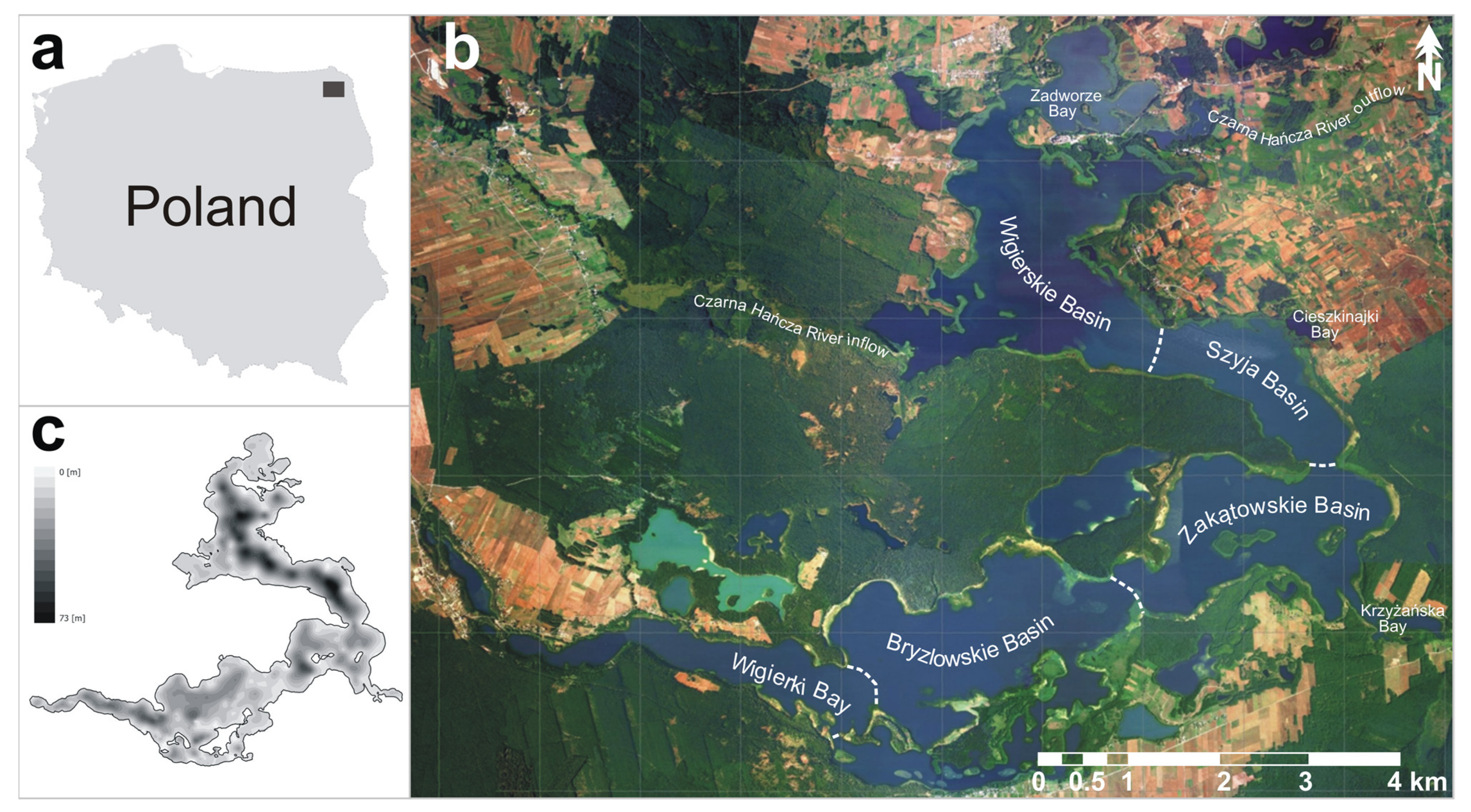
Figure 1. Study area: (a) location of the study area (gray rectangle) on the map of Poland; (b) Wigry Lake photomap (obtained courtesy of the Wigry National Park authorities) with the designation of five main parts of the lake (Wigierskie Basin, Szyja Basin, Zakątowskie Basin, Bryzglowskie Basin, and Wigierki Bay) and other important zones (Czarna Hańcza River inflow, Czarna Hańcza River outflow, Zadworze Bay, Cieszkinajki Bay, and Krzyżańska Bay); (c) bathymetry sketch of the Wigry Lake bottom.
Minerals 11 00158 g001
Figure 2. Principal component analysis (PCA) carried out for 177 Wigry Lake sediment samples, visualized according to sediment type (a) and depth (b).
Minerals 11 00158 g002
Figure 3. Iron in recent bottom sediments of the Wigry Lake: (a) spatial distribution of Fe; (b) Fe mapped according to different geochemical background values implemented in the study (Table 3).
Minerals 11 00158 g003
Figure 4. Manganese in recent bottom sediments of the Wigry Lake: (a) spatial distribution of Mn; (b) Mn mapped according to different geochemical background values implemented in the study (Table 3).
Minerals 11 00158 g004
Figure 5. Cadmium in recent bottom sediments of the Wigry Lake: (a) spatial distribution of Cd; (b) Cd mapped according to different geochemical background values implemented in the study (Table 3); (c) Cd mapped according to sediment quality guideline values (TEL—threshold effect level, TEC—threshold effect concentration, PEL—probable effect level, PEC—probable effect concentration [59,60]; Table 3).
Minerals 11 00158 g005
Figure 6. Chromium in recent bottom sediments of the Wigry Lake: (a) spatial distribution of Cr; (b) Cr mapped according to different geochemical background values implemented in the study (Table 3); (c) Cr mapped according to sediment quality guideline values (TEL—threshold effect level, TEC—threshold effect concentration, PEL—probable effect level, PEC—probable effect concentration [59,60]; Table 3).
Minerals 11 00158 g006
Figure 7. Copper in recent bottom sediments of the Wigry Lake: (a) spatial distribution of Cu; (b) Cu mapped according to different geochemical background values implemented in the study (Table 3); (c) Cu mapped according to sediment quality guideline values (TEL—threshold effect level, TEC—threshold effect concentration, PEL—probable effect level, PEC—probable effect concentration [59,60]; Table 3).
Minerals 11 00158 g007
Figure 8. Zinc in recent bottom sediments of the Wigry Lake: (a) spatial distribution of Zn; (b) Zn mapped according to different geochemical background values implemented in the study (Table 3); (c) Zn mapped according to sediment quality guideline values (TEL—threshold effect level, TEC—threshold effect concentration, PEL—probable effect level, PEC—probable effect concentration [59,60]; Table 3).
Minerals 11 00158 g008
Figure 9. Lead in recent bottom sediments of the Wigry Lake: (a) spatial distribution of Pb; (b) Pb mapped according to different geochemical background values implemented in the study (Table 3); (c) Pb mapped according to sediment quality guideline values (TEL—threshold effect level, TEC—threshold effect concentration, PEL—probable effect level, PEC—probable effect concentration [59,60]; Table 3).
Minerals 11 00158 g009
Table 1. Concentrations of selected metals in the LKSD-4 reference material, determined using different instrumental methods [113,114].
MetalLKSD-4 *ICP-MSICP-AESAAS
mg·kg−1
Cd1.92.2 ± 0.22.0 ± 0.22.0 ± 0.3
Cu31.029.8 ± 1.728.5 ± 1.630.5 ± 2.6
Mn420412 ± 7.9-405 ± 12
Pb91101 ± 3.899 ± 4.581.8 ± 5.1
Zn195202 ± 9.6200 ± 4.0190 ± 11
* The LKSD-4 reference material is a mixture of sediments from the Big Gull Lake in Ontario and the Key and Sea Horse Lakes in Saskatchewan and its main components are: SiO2 (41.6%), organic matter (as LOI, 500 °C) (40.8%), Al2O3 (5.9%), Fe2O3 (4.1%), and CaO (1.8%) [118].
Table 2. Basic statistics for metal concentrations in different types of Wigry Lake sediments [113,114].
MetalLacustrine ChalkCarbonate GyttjaFluvial-lacustrine SedimentOrganic GyttjaClastic SedimentAll Sediments
mg·kg−1
Cdn981491743271
Min0.0030.0100.1600.1200.0060.003
Max0.5570.8703.0600.6200.6333.060
Mean0.1330.3401.0770.3380.2360.310
Crn88136744239
Min0.200.424.070.823.390.20
Max4.3112.2522.617.784.1522.61
Mean1.483.6916.173.633.733.24
Cun102144744261
Min0.020.2012.273.070.080.02
Max8.9726.2759.7010.306.5559.70
Mean2.246.7841.566.682.345.87
Fen20021721912459
Min804845863254258180
Max558810,65432,85715,876318132,857
Mean983367018,377752914963191
Mnn20021621912458
Min1856142862818
Max20616981373372851698
Mean9435451823051238
Pbn72641457162
Min36.246.835.662.37.07.0
Max88.184.7107.579.463.8107.5
Mean71.660.678.271.421.865.7
Znn20021321912455
Min4.67.184.56.23.13.1
Max103.4119.3632.1105.960.2632.1
Mean17.844.6339.262.714.746.0
Table 3. Threshold values of geochemical backgrounds (GB1–GB5) and sediment quality guidelines (TEL, TEC, PEL, PEC) implemented for the assessment of the chemoecological state of Wigry Lake.
MetalGB1 1GB2 2GB3 3GB4 4GB5 5TEL 6TEC 7PEL 8PEC 9
mg·kg−1
Cd0.003 *-0.6310.5000.0350.5960.993.534.98
Cr0.99-6.085.0011.0037.343.490111
Cu0.5<1.0–4.011.16.04.035.731.6197149
Fe344100–13,800564010003800----
Mn8253–20464935001100----
Pb0.24.0–8.070.910.09.03535.891.3128
Zn4.02.0–36.073.548.020.0123121315459
* below the limit of quantification; 1 GB1—local geochemical background “a” [103,127]; 2 GB2—local geochemical background “b” [104]; 3 GB3—local geochemical background “c” [48]; 4 GB4—Polish geochemical background for aquatic sediments [128]; 5 GB5—world geochemical background for carbonates [56]; 6 TEL—threshold effect level [59]; 7 TEC—threshold effect concentration [60]; 8 PEL—probable effect level [59]; 9 PEC—probable effect concentration [60].
Publisher’s Note: MDPI stays neutral with regard to jurisdictional claims in published maps and institutional affiliations.