Abstract
Fractures are the main reservoir space in basement weathering crusts and control the development of dissolution/alteration pores. A clear understanding of the main factors controlling fracture formation is needed to accurately predict reservoir characteristics. In this study, the reservoir characteristics along with the vertical zonation and thermal history of basement weathering crust were studied through lithology, mineral identification, porosity and permeability tests, nuclear magnetic resonance (T2), whole-rock analysis, and fission-track dating based on core samples, cuttings, and imaging logging data. Under the constraints of the Anderson model, the formation stages and timing of fractures were analyzed according to the regional stress field, fracture strike, fracture filling characteristics, and rock mechanical properties. The results revealed tensile structural fractures, shear structural fractures, weathering micro-fractures, alteration fractures, and intracrystalline alteration pores in the weathering crust of the Pre-Cenozoic basement in Lishui Sag. The reservoirs were characterized by low porosity, low permeability, and small pore diameter. The reservoir quality of granite was better than that of gneiss. The weathering crust could be divided into four zones: the soil layer, weathering dissolution zone, weathering fracture zone, and bedrock zone. The thickness of the soil layer and weathering dissolution zone were small. Four stages of fractures were identified: Yandang movement shear fractures, Paleocene tension structural fractures, Huagang movement shear fractures, and Longjing movement shear fractures. The main stage of basement fracture formation differed between the Lingfeng buried hill zone and Xianqiao structural zone. Considering the influence of the temperature and pressure environment on the rock’s mechanical properties, the differential fracture formation is related to the lithology, the coupling between the uplifted and exposed basement histories, and the tectonic stress field. Combined with the thermal histories of the Lingfeng buried hill zone and Xianqiao structural zone, the results suggest that the Lingfeng buried hill granite is favorable for basement fractures in Lishui Sag. Overall, this paper provides a novel method for analyzing the stages of fracture formation.
1. Introduction
Oil and gas reservoirs associated with basement weathering crusts are widely distributed in basins around the world and are important reservoirs for oil and gas exploration [1,2,3,4]. Abundant oil and gas reservoirs have been discovered in the basement weathering crust of the Bohai Sea, Pearl River Estuary, and Qiongdongnan Basin in China, and basement weathering crusts have become an important focus of exploration to increase oil and gas reserves and production [5,6,7]. Throughout the country, with the discovery of the PL9-1 oilfield and the BZ19-6 gas field, the research on basement-weathering-crust-type reservoirs is increasing year by year, and the oil and gas production from basement weathering crusts are also constantly making breakthroughs. Basement-weathering-crust-type oil and gas reservoirs have become one of the key directions of domestic oil and gas exploration.
Granite and gneiss are the main rock types found in basement weathering crusts globally [8], and their reservoir characteristics and distributions are important for guiding oil and gas exploration. Weathering reservoirs are typically characterized by significant vertical zonation and can be divided into four or five zones according to rock appearance, mineral composition, and pore characteristics [9,10,11]. The zonation based on rock strength and permeability also reflects the degree of weathering [12]. Different basins show differences in vertical zone thickness, reservoir space composition, and the physical properties of the basement weathering crust, resulting in obvious differences in reservoir productivity.
The reservoir spaces in the weathering crust can be divided into fractures and alteration pores. Fractures provide fluid seepage channels for dissolution, thereby controlling the distribution of alteration pores. Therefore, understanding the origin and formation process of fractures is important in the study of weathering crust reservoirs [13]. The fracture formation process can be analyzed according to the characteristics of fracture fillings, the homogenization temperature and thermal history of fluid inclusions [14,15], and the occurrence of fractures combined with the regional tectonic stress field [16,17]. When the fracture is filled by calcite, the filling time can also be obtained using isotopic dating to define the fracture formation stage [18]. Fracture occurrence can be evaluated based on core data, imaging logging data, and seismic data. The presence of small- and medium-scale fractures can be revealed by core data, medium-scale fractures can be detected by image logging data, and seismic data can indicate the occurrence of large-scale fractures. The use of seismic data to reveal large-scale fractures has received considerable attention in the literature. In contrast, the detection of medium- and small-scale fractures by core data and imaging logging data has received relatively little research attention, leading to an incomplete understanding of fracture formation [8]. In addition, the development process of basement fractures differs significantly between different tectonic zones and is affected by the lithology, mineral composition, and erosion time [4,6]. Moreover, the confining pressure and temperature, which significantly influence the rock’s mechanical properties, have not received much attention, hindering our understanding of differential fracture formation.
Taking the basement of Lishui Sag in the East China Sea Basin as an example, we studied the reservoir characteristics of the weathering crust, attempted to match the core and imaging logging data, and analyzed the fracture formation process of weathering crust in the basement of the Lishui Sag in consideration of the regional tectonic stress field, rock mechanics, thermal history, and other factors. The findings reveal the main factors controlling differential fracture formation in the basement weather crust and provide a systematic basis for assessing the reservoir characteristics, fracture formation stage, and fracture distribution in weathering crusts.
2. Geologic Overview
2.1. Regional Geologic Characteristics
The East China Sea Basin consists of two parts: the East China Sea Shelf Basin and the Okinawa Trough Basin. The Lishui Sag is located in the southwestern part of the East China Sea Shelf Basin and is divided into the East Secondary Depression of Lishui, the West Secondary Depression of Lishui, and the Lingfeng buried hill zone; the Xianqiao structural zone is distributed in the northern part of the West Secondary Depression of Lishui (Figure 1). The Cenozoic tectonic evolution of the basin can be divided into the rift period, compression reversal period, and thermal subsidence period [19]. The timing of these three stages differs between the faulted depressions in the west and east. The rift period of the western depression zone occurred from 65 to 56.5 Ma, and the basin was filled with the Yuefeng Formation, Lingfeng Formation, and Mingyue Formation from the bottom to top. The compression–inversion stage lasted from 56.5 to 23.3 Ma, and the basin was filled with the early Eocene Oujiang Formation and Wenzhou Formation, which exhibit folding deformation. From 23.3 Ma to present, the western depression zone has been in the thermal subsidence stage. During this stage, the basin has been filled with the Longjing Formation, Yuquan Formation, Liulang Formation, Santan Formation, and Donghai Group, and the resulting strata are weakly deformed and nearly horizontal. In the eastern depression zone, the rift period lasted from 56.5 to 32 Ma, and the basin was filled with the Baoshi Formation and Pinghu Formation from bottom to top. The compression–inversion stage occurred from 32 to 23.3 Ma, and the basin was filled with the Huagang Formation, which is characterized by folding deformation. From 23.3 Ma to present, the eastern depression zone has been in the thermal subsidence stage (the same as the western depression zone) [20]. In summary, during the Paleogene period, tectonic movement from the west to east occurred in the study region [21].
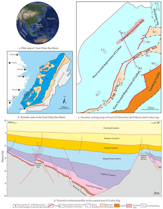
Figure 1.
Location of the Lishui Sag and its wells, as well as the tectonic evolution profile in the study area.
2.2. Basement Lithology
The Pre-Cenozoic basement of the East China Sea Basin belongs to the South China block, and the main rock types of the basement of the East China Sea Basin are consistent with the Mesozoic granitic intrusive rocks and Proterozoic metamorphic rocks that are widely exposed in coastal areas. The outcrop area reveals that the granite formation gradually migrated from west to east [22,23,24,25]. Triassic granites are mainly distributed in the eastern part of Hunan, Early Jurassic granites are mainly distributed in the western part of Jiangxi, Middle Jurassic granites are mainly distributed in the central and eastern part of Jiangxi, Late Jurassic granites are mainly distributed in the western part of Fujian, and Cretaceous granites are mainly distributed in the eastern coastal area of Fujian [19,26,27]. The Lishui Sag contains 10 bore holes, which reveal a crystalline and metamorphic basement (approximately 1000 m in depth), and there is no chronological pattern in the relationship between the ages of the vertical and lateral lithological successions of the basement.
Based on the international classification scheme of igneous rocks proposed by the Igneous Rock Classification Committee of the International Union of Geosciences [28] and the classification scheme for metamorphic rocks proposed by the Metamorphic Rock Identification Manual [29], 13 lithologies were identified by consensus: four kinds of deep intrusive rocks [granodiorite (3.2%), monzonitic granite (37.0%), syenite granite (0.8%), and quartz diorite (4.0%)]; one shallow intrusive rock [diorite porphyrite (0.4%)]; five regional metamorphic rocks [biotite plagioclase gneiss (40.4%), biotite quartz gneiss (1.6%), two-mica gneiss (0.8%), biotite schist (0.8%), and two-mica quartz biotite schist (0.8%)]; and three dynamic metamorphic rocks [fragmented gneiss (1.6%), fragmented granite (3.6%), and early mylonite (0.8%)]. The monzonite granite was formed in the Jurassic–Cretaceous period, while the biotite plagioclase gneiss was formed in the late Proterozoic period. Among the drilled wells, three wells revealed gneiss, two wells revealed cataclastic rocks, one well revealed mylonite, and eight wells revealed intrusive rocks [30].
3. Samples and Test Methods
3.1. Samples
The experimental samples were collected from wells L1 (gneiss) and W2 (granite) in the Lingfeng buried hill zone of Lishui Sag. A total of 3.38 m of rock core, 26 wall core samples, and 86 cut samples were collected. The samples included 26 porosity and permeability samples (17 gneiss samples, 3 granite samples, and 6 cataclastic granite samples); 4 gneiss nuclear magnetic resonance (NMR) samples; and one gneiss overburden pore permeability sample. The samples included 86 whole-rock principal element samples: 53 gneiss samples from well L1 and 33 granite samples from well W2, all collected from detritus. One gneiss sample for fission-track dating was obtained from the core. In addition, 26 Jurassic–Cretaceous granite samples for porosity and permeability testing along with 4 NMR samples were collected from the Xiapu area in eastern Fujian for analysis and comparison. The NMR sample information of well L1 is shown in Table 1, and the specific information of field samples can be found in reference [31].

Table 1.
NMR sample information of well L1.
3.2. NMR Analysis
NMR analyses were completed at the Key Laboratory of Mineral Resources Evaluation in Northeast Asia, Ministry of Natural Resources, Jilin University. The NMR experiments used plunger samples, which were pre-treated by complete saturation (i.e., 100% water saturation). A MicroMR12-025V NMR analyzer (Shanghai Niumai Company, Shanghai, China) was used to record NMR T2 spectra, and the NMR experiments were conducted in accordance with the “Conventional Core Analysis Method” in the oil and gas industry (SY/T5336-2006) [32] and “Laboratory Measurement Specification for Nuclear Magnetic Resonance Parameters of Rock Samples” (SY/T6490-2014) [33]. A total of 4 gneiss from well L1 and 4 granite samples from the Xiapu area in eastern Fujian were analyzed.
3.3. Porosity and Permeability
Helium injection tests of porosity and permeability were completed in the Rock Physics Laboratory of Jilin University using an AP608 instrument at a temperature of 20 °C. The test procedures were in accordance with the “Conventional Core Analysis Method” in the oil and gas industry (SY/T5336-2006) [32]. The permeability and porosity were measured for 51 samples from wells L1, L2, W2, W3, and also terrestrial granite.
3.4. Whole-Rock Major and Trace Element Compositions
The whole-rock major and trace element compositions were analyzed at the Key Laboratory of Mineral Resources Evaluation in Northeast Asia, Ministry of Natural Resources, Jilin University. Fresh rock samples, which were selected based on the identified petrographic characteristics, were washed with distilled water, dried, crushed to 200 mesh, and analyzed using an X-ray fluorescence (XRF) spectrometer with a relative error of 1%–3%. A total of 53 gneiss samples from well L1 and 38 granite samples from well W2 were analyzed.
3.5. Fission-Track Dating
Apatite single crystals were selected for fission-track dating in the laboratory of the Hebei Regional Geological and Mineral Survey Institute. Sample preparation and testing were completed in the Key Laboratory of Mineral Resources Evaluation in Northeast Asia, Ministry of Natural Resources, Jilin University. Laser ablation inductively coupled plasma mass spectrometry was used for the analysis of 238U in apatite. The laser source was a New Wave UP213 Nd:YAG solid-state laser, and the mass spectrometer was an Agilent 7900 quadrupole plasma mass spectrometer. One gneiss sample from well L1 was analyzed, and the thermal history was simulated based on the isothermal annealing model of Ketcham to reveal the basement uplift and burial history. Time–temperature inversion was carried out using HeFTy 1.9.1 software according to the obtained apatite fission-track age and length distribution parameters. Apatite had annealing characteristics, whereby the length distribution would shorten with the increase in temperature. Therefore, the combination of fission-track age and length distribution parameters could quantitatively recover the temperature–time trajectory of rock mass. The initial temperature of the simulation was set as the surface temperature, and the initial time was the age of the formation of the sample. The time–temperature inversion curve was fitted using a Monte Carlo algorithm with 10,000 fittings and an initial track length of 16.3 μm. The maximum diameter of the fission-track etched parallel to the C-axis of the crystal was 1.65 μm.
3.6. Fracture Interpretation Based on Imaging Logging
The imaging logging data used for fracture interpretation were derived from CNOOC (China) Shanghai Branch, and the images were provided by a Schlumberger CWLS log ASCII Standard-VERSION 2.0 electric imaging instrument. Generally, fractures appear as sinusoidal curves in the images. The sine curve was fitted at any three points on the fracture trajectory, and the dip angle of the fracture was calculated according to the distance between the peak and trough of the apparent sinusoidal strip on the imaging map. The fracture trend was obtained according to the orientation of the apparent sinusoidal strip trough, and the average inclination and dip angle were calculated for irregular-shaped fractures [34,35]. In this research, high-resistance fractures with a high filling degree and low-resistance fractures with a low filling degree were identified using imaging techniques, and the results were confirmed by the core data; this indicated that the fracture identification results were credible.
3.7. Chemical Index of Alteration (CIA)
The chemical index of alteration (CIA) was calculated as follows:
CIA = Al2O3/(Al2O3 + CaO* + Na2O + K2O) × 100%.
The mole fraction of each component is adopted in the formula of CIA, and CaO* is the mole fraction of the CaO in the silicate. The formula CaO* = (CaO) (10/3) × P2O5, is generally used for the calculation and correction of the CaO. In this study, the method proposed by [36] was used to correct the CaO. During the chemical weathering of the upper crust, feldspar becomes the main parent rock mineral, and alkali metals such as Na, K, and Ca are lost in the form of ions and form clay minerals (e.g., kaolinite, montmorillonite, and illite). During this process, the mole fraction of Al2O3, i.e., the main component of the weathering products, will change with the intensity of chemical weathering. Therefore, the CIA of granite can be used as an index to reflect the weathering degree of the source area [37,38].
4. Characteristics of the Reservoir Space in the Basement Weathering Crust
A total of 3.38 m of core samples, including 18 sidewall core samples and 243 cutting samples, were obtained from the basement of Lishui Sag. According to the genetic and morphological classification schemes of the reservoir space [39], the reservoir spaces in the study area were primarily classified as secondary fractures and alteration micropores.
4.1. Fracture Characteristics
The fractures were subdivided into tensile structural fractures, shear structural fractures, weathering micro-fractures, and alteration fractures (Table 2). Tensile structural fractures are consistent with the direction of the maximum stress and are produced when the rock is subjected to shear stress; their occurrence varies, their geometry is jagged, and their fracture plane is irregular. The core samples from well L1 indicate a fracture width in the range of tens of micrometers to several millimeters, the degree of filling was high, and the filling material was clay. The presence of fractures indicates that the rock underwent fragmentation, and the fracture surface density was 45–87 m/m2 (Figure 2a).

Table 2.
Void space types and characteristics of the Pre-Cenozoic basement in Lishui Sag.
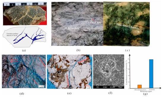
Figure 2.
Reservoir space types and characteristics of the Pre-Cenozoic basement in Lishui Sag. Notes: (a). L1, 2589.85–2589.90 m, Gneiss, tensile tectonic fracture; (b). L1, 2590.00–2590.04 m, Gneiss, shear tectonic fracture; (c). W2, 3624.0 m, Granite, shear tectonic fracture; (d). L1, 2756 m, Gneiss, weathering fractures, solution fractures and solution micropores develop; (e). L1, 2526–2528 m, Gneiss, weathering fractures and dissolution fractures develop; (f). W2, 3620.0 m, Granite feldspar is dissolved to form solution holes; (g). L1 Statistical table of the contribution of buried hill belt reservoir space to porosity.
Shear structural fractures are found in rocks subjected to shear stress and are usually conjugated with a high dip angle, straight fracture surface, and high extension. The core samples from well L1 indicate a shear fracture width of several micrometers to tens of micrometers. The apparent length reached tens of centimeters, and the fracture surface density was 17–30 m/m2. Scratches and steps were also seen on the surfaces of shear structural fractures, proving that the fault comprises left lateral movement (Figure 2b). The sample from well W2 also revealed a shear fracture with a relatively flat fracture surface (Figure 2c).
Weathering fractures are caused by stress release, as well as both physical and chemical weathering when rocks are uplifted near the surface. Stress release often results in layered joints. A rock cut by more than three sets of joints can produce annular joints during physical and chemical weathering. Rocks near the surface generate abundant weathered micro-fractures under the effects of meteoric water dissolution, temperature changes, and biological processes. Macroscopic weathering fractures are common in outcrops and are difficult to identify due to the lack of drilling cores and the fact that cores are taken from the bedrock and fracture zones. In this study, alkaline feldspar was found to develop rich weathered micro-fractures in thin sections; these micro-fractures came together into a network structure, had irregular surfaces with widths of a few microns to ten microns, and had a fracture surface density of up to thousands of m/m2 (Figure 2d,e).
Alteration fractures are formed by dissolution along the fracture wall under the action of CO2-containing atmospheric water, formation water, or deep fluid, resulting in the widening of the fracture. The alteration fractures have random directions, good connectivity, wavy fracture surfaces, and widths of up to 20 µm (Figure 2d,e).
4.2. Characteristics of Alteration Pores
The secondary pores developed in the study area are mainly alteration micropores, which are micropores produced by the dissolution of minerals in rocks (mica, amphibole, feldspar, etc.) by atmospheric water, formation fluids, or deep fluids. The pore diameters of the alteration micropores range from several micrometers to tens of micrometers (Figure 2f), and most are distributed along fractures and have irregular shapes.
By analyzing the porosity of the image surface and including both the pores and the fractures, 53 samples of gneiss from well L1 and 10 samples of granite from well W2 were obtained. For the gneiss samples, the contribution of fractures to total porosity was 90%, whereas the contribution of solution pores to total porosity was only 10% (Figure 2g). For the granite samples, the contributions of fractures and solution pores to total porosity were 85% and 15%, respectively. Thus, the gneiss and granite reservoirs belong to fracture-type reservoirs.
5. Reservoir Physical Characteristics
5.1. Porosity and Permeability
Porosity and permeability tests were conducted for four wells. Given the limited number of granite samples, the analysis was conducted using samples of similar age and lithology from the basin edge outcrop area. The porosity of Proterozoic gneiss in well L1 was 0.55%–3.80% with a geometric mean of 1.14%, and the permeability was 0.007–0.040 mD with a geometric mean of 0.016 mD. These values indicate a reservoir with low porosity and ultra-low permeability. The porosity of the Proterozoic gneiss in well L2 was 1.30%–1.99% with a geometric mean of 1.62%, and the permeability was 0.300–0.600 mD with a geometric mean of 0.472 mD. These values indicate a low-porosity and low-permeability reservoir. The porosity of fractured granite in well W3 was 15.90%–20.80% with a geometric mean of 17.79%. The permeability was 2.300–19.000 mD with a mean of 9.860 mD, indicating a medium-porosity and medium-permeability reservoir. The porosity of granite in well W2 was 0.20%–1.50% with a geometric mean of 0.58%, and the permeability was 0.010–11.900 mD with a geometric mean of 0.106 mD, indicating a reservoir with extremely low porosity and low permeability. The porosity of outcrop granite was 0.76%–10.00% with a geometric mean of 3.71%, and the permeability was 0.004–10.910 mD with a geometric mean of 0.065 mD, indicating a low-porosity and ultra-low-permeability reservoir.
According to the classification criteria for oil and gas reservoirs (SY/T6285-2011) [40], the fractured granite reservoir meets the standard for an “excellent” reservoir, whereas the granite reservoir of well W2 and the gneiss reservoir of well L1 are “insignificant” reservoirs. The reservoirs were classified using the “Evaluating Methods of Oil and Gas Reservoirs: SY/T6285-2011” standard. The granite reservoir of Xiapu-Fuding on the edge of the basin in Fujian meets the requirements of a “fair” reservoir (Figure 3). Therefore, the physical properties of the granite reservoir are better than those of the gneiss reservoir, and fragmentation can significantly improve the physical properties of the reservoir.
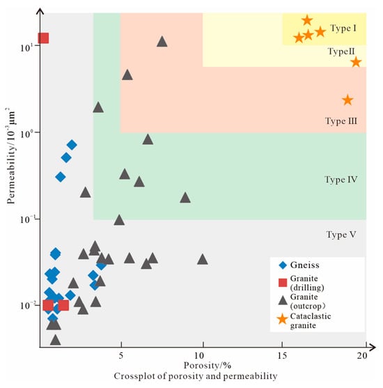
Figure 3.
Petrophysical characteristics of reservoirs in the Pre-Cenozoic basement of Lishui Sag.
5.2. Pore Diameter
The NMR T2 spectra were obtained for four samples from well L1. The samples from 2565.24, 2589.49, and 2590.91 m showed unimodal spectra with relaxation times less than 1 ms, indicating small pore diameters that may correspond to alteration micropores. In contrast, the sample from 2590.17 m produced a trimodal spectrum with a relaxation time of less than 10 ms, also indicating a reservoir dominated by small pores such as alteration micropores (Figure 4a).
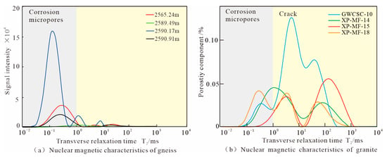
Figure 4.
Pore diameter characteristics of the Pre-Cenozoic basement of Lishui Sag and its adjacent areas from well L1.
Based on the NMR T2 spectra measured for the outcrop samples, the relaxation time of the granite samples ranged from 0.1 to 1000 ms, indicating a wide range of pore diameters. The spectra of most of the samples were polymodal. The spectra of samples XP-MF-14 and XP-MF-15 are bimodal, the spectrum of sample XP-MF-18 is trimodal, and the spectrum of sample GWCSC-10 is unimodal. For all four samples, the largest contribution to porosity was made by pores with relaxation times greater than 1 ms. For reservoirs with a large pore diameter, the reservoir space should be primarily fracture micropores (Figure 4b).
6. Zoning of Basement Weathering Crust Reservoirs
When basement rocks are exposed at or near the surface, weathering occurs from the top to bottom, resulting in significant zonation. The parameters that reflect the weathering degree include the chemical index of alteration (CIA), loss on ignition (LOI), fracture density, and clay mineral content. LOI reflects the structural water content in rocks. Altered rocks are usually rich in clay minerals, which contain abundant structural water. Stronger chemical weathering corresponds to a greater clay content and a greater LOI. CIA also reflects the degree of chemical weathering, with large CIA values indicating severe weathering. Both LOI and CIA are obtained through the test of the major element, both can reflect the degree of weathering of the rock. Physical weathering easily leads to fracturing, and the fracture density is positively correlated with the degree of physical weathering. According to the characteristics of chemical and physical weathering in the study area, the weathering crust could be divided into the soil zone, weathering and dissolution zone, weathering fracture zone, and bedrock zone. Gneiss and granite are developed in the study area; the vertical zoning characteristics are introduced below.
6.1. Proterozoic Gneiss in the Lingfeng Buried Hill Zone
Based on well L1, the depth of the buried hill section ranges from 2496.0 to 2980.0 m (a total of 484.0 m), and gneiss is the main lithology. The vertical zonation was characterized according to the LOI and CIA values of 53 samples, the surface porosity and fracture areal rate of 49 samples, and the fracture density of 15 samples. The soil zone and weathering and dissolution zone are located at depths of 2496.0–2512.0 m, the weathering fracture zone extends from 2512.0 to 2638.0 m, and the bedrock zone, in which the fracture zone was developed, was found below 2638.0 m.
For the soil zone and weathering and dissolution zone, LOI ranged from 2.35% to 4.66% with a geometric mean of 3.09%, and CIA ranged from 62.22% to 69.52% with a geometric mean of 65.74% (Figure 5). The fracture density identified by imaging logging was 13.0 m/m2. Due to the insufficient number of samples from the soil zone and weathering and dissolution zone, the surface porosity and fracture areal rate could not be obtained in these layers. Based on the thin-section cuttings, mica was dissolved and transformed into chlorite, and the sericitization of feldspar also occurred; however, the original appearance of the rock remained relatively clear, and the degree of chemical weathering was strong-to-medium, overall. Considering that it was difficult to distinguish the soil zone from mud in cuttings and identify them separately due to the low thickness of these layers, the soil zone and weathering and dissolution zone were not distinguished in well L1.
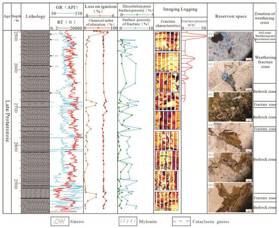
Figure 5.
Vertical zonation characteristics of the weathering crust reservoir of the late Proterozoic gneiss from well L1 in the Lingfeng buried hill zone of Lishui Sag. Notes: (P1) well L1, 2512–2514 m, weathering fracture zone, alteration pores of plagioclase; (P2) well L1, 2512–2514 m, weathering fracture zone, biotite chloritization forms alteration pores; (P3) well L1, 2534–2536 m, weathering fracture zone, dark mineral alteration forms alteration pores; (P4) well L1, 2560–2562 m, weathering fracture zone, dark minerals with a few developed fractures; (P5) well L1, 2598–2600 m, weathering fracture zone, alteration pores are hardly developed; (P6) well L1, 2662–2664 m, bedrock zone, alteration pores are not developed.
In the weathering fracture zone, the LOI ranged from 0.35% to 1.05% with a geometric mean of 0.65%, and CIA ranged from 56.59% to 58.97% with a geometric mean of 57.72%. The fracture areal rate ranged from 1.1% to 5.5% with a geometric mean of 3.3%. The fracture density ranged from 5.0 to 50.0 m/m2. The fracture surface density ranged from 5.0 to 50.0 m/m2, with most values lying between 15.0 and 30.0 m/m2; the geometric mean was 13.5 m/m2. The surface porosity ranged from 0.1% to 0.7% with a geometric mean of 0.2%. These data indicate that the rocks in the weathering fracture zone were significantly physically weathered but weakly chemically weathered (Figure 5). Imaging logging showed fracture development. A few alteration micropores were observed in the thin section in feldspar and mica, and the degree of dissolution decreased with increasing depth (Figure 5, P1–P5).
In the bedrock zone, LOI ranged from 0.09% to 2.31% with a geometric mean of 0.50%, and CIA ranged from 54.95% to 69.03% with a geometric mean of 59.41%. The fracture areal rate ranged from 0.1% to 6.2% with a geometric mean of 2.2%. The surface porosity ranged from 0.1% to 1.4% with a geometric mean of 0.2%. The fracture density ranged from 8.0 to 9.0 m/m2 with a geometric mean of 8.5 m/m2. Only a few alteration micropores were developed in the rocks of the bedrock zone (Figure 5, P6), indicating that the rocks were weakly affected by chemical weathering. The interval with high LOI, large CIA, and high fracture areal rate corresponded to the excavation-damaged zone in the bedrock zone (Figure 5). The LOI of the excavation-damaged zone ranged from 0.45% to 2.31% with a geometric mean of 1.43%, and the CIA ranged from 54.95% to 65.62% with a geometric mean of 61.26%. The fracture areal rate ranged from 2.3% to 6.2% with a geometric mean of 3.9%. The surface porosity ranged from 0.1% to 1.4% with a geometric mean of 0.3%. These results indicate that the excavation-damaged zone was the zone of reservoir development in the bedrock zone.
6.2. Jurassic Granite in the Xianqiao Structural Zone
The buried hill section from well W2 ranged from 3597.9 to 3635.0 m in depth (a total of 37.1 m). Monzogranite and granodiorite were the main lithology. Only 38 samples were obtained for this well for CIA and imaging logging analysis. Resistivity logging (Rd), density logging (DEN), and acoustic logging (DT) data were also collected, as shown in Figure 6. The results show that the soil zone was located at depths of 3597.9–3598.2 m, the weathering and dissolution zone extended from 3598.2 to 3620.5 m, the weathering fracture zone was located from 3620.5 to 3635.5 m, and the bedrock zone was not revealed.
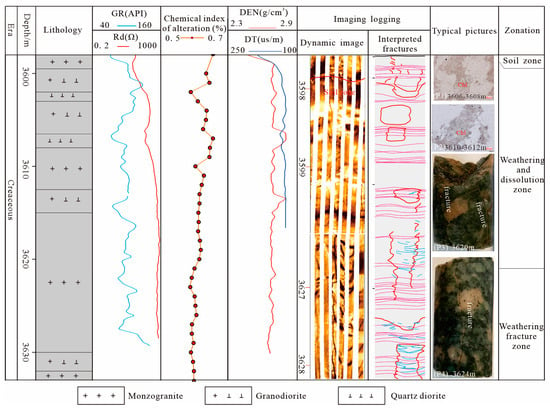
Figure 6.
Vertical zonation characteristics of Cretaceous granite weathering crust reservoirs in well W2 of the Xianqiao structural zone in Lishui Sag. Notes: The purple fractures represent low-angle fractures, the red fractures represent high-angle fractures, and the blue fractures represent weathering fractures.
For the soil zone, CIA ranged from 58.90% to 63.55%, Rd ranged from 40.80 to 43.26 Ω·m, and DEN was 2.46–2.51 g/cm3 with a geometric mean of 2.48 g/cm3. DT ranged from 240.01 to 244.99 μs/m with a geometric mean of 242.91 μs/m. This layer was greatly affected by chemical weathering. The low-resistivity interval based on imaging logging showed patchy areas of high resistivity, which can be interpreted as gravel in the soil layer. This section was comprehensively interpreted as the soil layer (Figure 6).
In the weathering and dissolution zone, CIA was 54.84%–61.91% with a geometric mean of 59.54%, Rd was 30.07–868.57 Ω·m with a geometric mean of 287.57 Ω·m, DEN was 2.54–2.80 g/cm3 with a geometric mean of 2.70 g/cm3, and DT was 163.65–235.03 μs/m with a geometric mean of 171.5 μs/m. This section was characterized by moderate chemical weathering. Imaging logging and analysis of wall core samples showed developed fractures, and thin-section cuttings exhibited a certain degree of feldspar dissolution and transformation into clay minerals such as kaolinite and chlorite. The results indicate moderate chemical weathering and strong physical weathering in the weathering dissolution zone (Figure 6).
In the weathering fracture zone, CIA was 50.46%–60.61% with a geometric mean of 57.65%, Rd was 596.30–744.70 Ω·m with a geometric mean of 660.42 Ω·m, DEN was 2.65–2.71 g/cm3 with a geometric mean of 2.68 g/cm3, and DT was 163.65–235.03 μs/m with a geometric mean of 171.5 μs/m. The acoustic logging data were invalid, and the imaging logging data and analysis of wall core samples showed fracture development. The whole rock was affected by tectonic action to form macro-structural fractures, and the quartz and feldspars were subjected to physical weathering to form microscopic weathering fractures. The results indicate low chemical weathering and moderate physical weathering in the weathering fracture zone (Figure 6).
The degree of chemical weathering is based on the classification method of reference [31] and the classification scheme summarized by wells in the study area. Overall, the soil zone and the weathering and dissolution zone of the basement weathering crust in the Lingfeng buried hill and Xianqiao structural belt in Lishui Sag were thin and difficult to distinguish, indicating weak chemical weathering. The thickness of the weathering fracture zone reached 122 m, indicating that the basement of the study area has the conditions necessary to form high-quality fracture-type reservoirs.
7. Formation Stages of Basement Fractures and the Main Factors Controlling Fracture Formation
The main factors that control the occurrence of fractures in granite and gneiss are mainly the mechanical properties of the rock and the stress field. This paper focuses on the relationship between the stress field and fractures.
7.1. Characteristics of the Regional Stress Field and Formation Stages of Tectonic Fractures
In this paper, fracture formation stages are analyzed according to the matching relationship between the regional tectonic stress field and fracture strike revealed by imaging logging.
7.1.1. Characteristics of the Regional Stress Field
The tectonic stress field in Lishui Sag can be divided into three stages from the Jurassic to Neogene periods: (1) the alternating stage of the NNW–SSE compression stress field and the NWW–SEE extensional stress field from the Middle Jurassic to the Eocene [41,42,43,44,45,46,47]; (2) the stage of the NW–SE extensional stress field and the NW–SE compression stress field from the Oligocene to the Miocene [48,49,50,51,52]; and (3) the NNW–SSE extensional stress field and the nearly east–west compression stress field from the end of the Miocene to the Pliocene [53,54,55,56,57]. The relationship between the stress field and fracture strike is shown in Figure 6.
7.1.2. Formation Stages of Tectonic Fractures
According to the fracture characteristics revealed by the analysis of core samples and imaging logging (only the data for wells L1 and W2 are complete) along with the characteristics of the regional tectonic stress field and the uplift and burial history of the buried hill, we analyzed the fracture formation stages. We identified four primary stages of structural fracture formation in well L1. The first stage of fractures is shear fractures formed during the Yandang movement in the Late Cretaceous period. These are high-angle fractures with good continuity that appear as a nearly upright, low-resistance line on the imaging log data. The apparent length is relatively large, with an average inclination angle of 50° and a nearly upright NNW–SSE strike. The second stage of fractures is tensile fractures formed during the Paleocene rifted period. These fractures have medium-to-low angles with an average inclination angle of 25° and a dominant NE–SW strike. The third stage of fractures is shear fractures formed during the Huagang movement at the end of the Oligocene epoch. These fractures show low resistance, good ductility, high angle, and take the form of a nearly vertical line with an average inclination angle of 50° and an NW–SE strike. The fourth stage of fractures is shear fractures formed during the Longjing movement. These fractures exhibit low resistance and high angle with an average inclination angle of 70° and a dominant NWW–SEE strike (Figure 7).
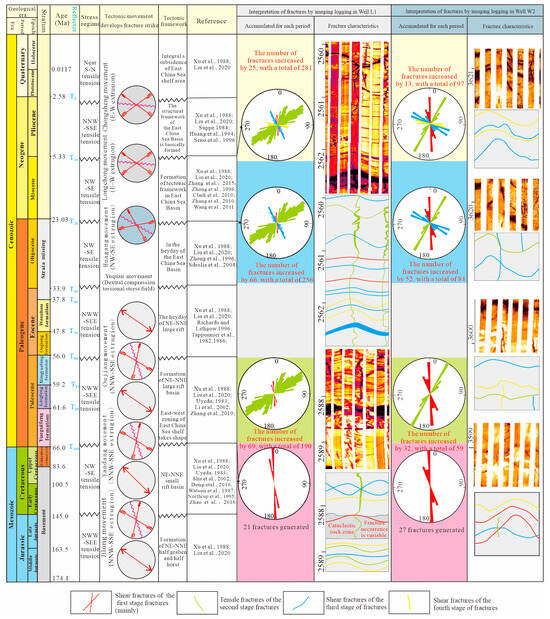
Figure 7.
Formation stages of fractures in the weathering crust of the Pre-Cenozoic basement in Lishui Sag. Notes: The formation stages of tectonic fractures were determined based on the regional tectonic stress field, fracture strike revealed by imaging logging, and the uplift and burial history of the buried hill [41,42,43,44,45,46,47,48,50,51,52,53,54,55,56,57].
Four main stages of structural fractures were identified in well W2. The first stage is shear fractures formed during the Yandang movement. These NNW–SSE-striking fractures have flat surfaces and low angles. The second stage of fractures is tensile fractures formed during the Paleocene epoch. These NE–SW-striking fractures show tooth-shaped surfaces and low or intermediate angles. The third stage of fractures is shear fractures formed during the Huagang movement. These fractures strike NW–SE and have flat fracture surfaces and high angles (inclination angles up to 85°). The fourth stage of fractures is shear fractures formed during the Longjing movement. These fractures strike NWW–SEE and show flat fracture surfaces and intermediate to high angles (Figure 7).
7.2. Differences in Tectonic Fractures
From the perspective of the formation stages of basement tectonic fractures, the Lingfeng burial hill zone and Xianqiao structural zone are consistent. However, significant differences were observed in the proportion of structural fractures in each stage. The tectonic fractures in well L1 are extensional fractures of the second stage that mainly formed in the Paleocene epoch, accounting for 61% of the total number of fractures. Shear tectonic fractures from the third stage that were generated during the Huagang movement in the late Oligocene epoch were the secondary contributors, accounting for approximately 23% of the total number of fractures. The percentage of the total number of fractures from the other two stages was only 16%. The tectonic fractures in well W2 were mainly tensile fractures of the second Paleocene epoch, accounting for 33% of the total fractures. The shear fractures in the first stage of the Yandang movement accounted for 28%, while the contributions of fractures in the third and fourth stages were 26% and 13%, respectively. Therefore, the Xianqiao structural zone and Lingfeng buried hill zone showed differences in the main stage of fracture formation.
Based on the interpretation of imaging logging data, the average fracture line density of gneiss in well L1 was 1.4 per meter, and that of granite in well W2 was 2.5 per meter. The porosity and permeability of well W3 were significantly higher than those of wells L1 and W2, indicating differences in the degree of fracture formation among different lithologies.
7.3. Main Factors Controlling Differential Fracture Formation
Basement differential fracture formation refers to the different formation processes of structural fractures (e.g., the different contributions of fractures in different stages and the different fracture densities among different lithologies). From the perspective of fracture genesis, the comprehensive effect of the regional stress field and the rock’s mechanical properties are key to differential fracture formation. Due to the limitations in the precision of paleo-regional investigations of the stress field, it is difficult to clarify the different stress fields in wells L1 and W2 in Lishui Sag. In this study, we focused on the effects of rock mechanical properties on differential fracture formation. The rock mineral contents and confining pressures affect the rock’s mechanical properties, which in turn affect the ease of fracture formation. The content of dark minerals determines the fracture ability of rocks. Due to their strong compressive resistance, dark minerals are dominated by ductile deformation under stress, making it difficult to produce fractures. The dark minerals in granite are mainly biotite. Under certain confining pressures, the tri-axial compressive strength increases with increasing biotite content. However, for a constant biotite content and confining pressure of 20 Mpa, the tri-axial compressive strength of rock is higher than that at a confining pressure of 0 Mpa; thus, the compressive strength of rock increases with increasing confining pressure under the same biotite content (Figure 8). In addition, different temperature and pressure conditions will lead to changes in the rock’s mechanical properties, resulting in different degrees of fracture ability under the same stress condition. Because the breakdown pressure of rocks in the burial stage is significantly higher than that in the state without confining pressure, rocks near the surface are more likely to form fractures under the action of tectonic stress. Fractures are also significantly more likely to form in the cooling stage than in the heating stage [58,59]; thus, the basement uplift stage is more conducive to the formation of fractures. Differential fracture formation is apparent when the stress causing the same tectonic movement is applied to rocks with different burial depths at different structural positions. Considering fracture formation under different temperature and pressure conditions, we discuss the characteristics of differential fracture formation between wells L1 and W2.
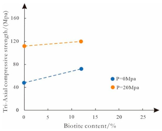
Figure 8.
Compressive strength of rocks with different biotite contents [4].
For well L1 in the Lingfeng buried hill zone, the first stage of fractures formed during the Yandang movement, which was in a state of uplift and cooling, but the formation temperature of the top surface of the basement was approximately 30 °C, while the formation temperature of the surface was approximately 20 °C. According to a formation temperature gradient of 3.5 °C/100 m, the burial depth was approximately 286 m, which was not conducive to fracture formation, and only a few fractures formed. The second stage of fracture formation was the main stage of fracture formation and occurred when the basement was not covered by overlying strata. This was the most favorable environment for fracture formation, and tensile fractures were produced under NE–SE compression stress. The third stage of fractures formed during the Huagang movement when the basement was once again uplifted and cooled, creating a favorable environment for fracture formation. Shear fractures were produced under NW–SE compressive stress. During the Longjing movement in the fourth fracture-forming stage, the basement was again buried and heated under increasing confining pressure. These conditions were not conducive to fracture formation, and only a few faults were formed. The scratches and steps identified in the core should belong to this stage (Figure 2b and Figure 9).
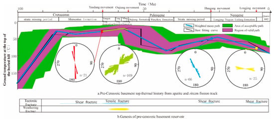
Figure 9.
Formation and evolution of fractures in the late Proterozoic gneiss of well L1 in the Lingfeng buried hill of Lishui Sag.
For well W2 in the Xianqiao structural zone, the first stage of fractures formed during the Yandang movement. This stage was characterized by burial and heating, which was not conducive to fracture formation. The second stage of fracture formation occurred during the extensional background of the Paleocene epoch when the basement was further buried and heated, making the rifting environment even more unfavorable. In the third stage of fracture formation, the basement underwent a process of uplift and cooling. However, the burial depth remained large, which was not conducive to fracture formation. The temperature and pressure conditions in the fourth stage of fracture formation were similar to those in the third stage. Therefore, the temperature and pressure environment of well W2 was generally poor for fracture formation (Figure 10).
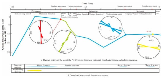
Figure 10.
Formation and evolution of fractures in the Jurassic granite of well W2 in the Xianqiao structural zone of Lishui Sag.
In general, there were significant differences in the exposure time and burial process of the basement between the Lingfeng burial hill zone and Xianqiao structural zone. The differences in the mechanical properties of the same lithology at different burial depths led to significant differences in the characteristics of fracture formation in these two tectonic zones under different stages of stress. According to the fracture characteristics derived from imaging logging of the Lingfeng burial hill zone and the Xianqiao structural zone, the inclination angles of the fractures were mostly low to intermediate, the direction of minimum principal stress was vertical, and the difference between the maximum and minimum principal stresses was significantly affected by the burial depth. The burial depth of well L1 was less than that of well W2 in all four fracture stages. Under the same tectonic stress in the same area, the difference between the maximum and minimum principal stresses was smaller in well L1 than in well W2, making well L1 more conducive to fracture formation. The stress environment in the basement of the Lingfeng buried hill zone, as well as the coupling between the uplifted and exposed basement histories, were better for fracture formation than those in the Xianqiao structural zone.
7.4. Distribution and Exploration Significance of Buried Hill Fractures
The weathering crust of the buried hill in this area can be divided into the soil layer, weathering dissolution zone, weathering fracture zone, and bedrock zone (Figure 11a), and the reservoir space is mainly structural fractures. The soil layer is relatively thin, and bioclasts were observed under a microscope (Figure 11b-I), indicating the existence of biological weathering. The rock had a high shale content along with serious calcareous cementation. The resistivity of gneiss in the soil layer was 100.88 Ω·m, DT was 185.53 μs/m, and DEN was 2.75 g/cm3. The resistivity of granite in the soil layer was 43.21 Ω·m, DT was 241.76 μs/m, and DEN was 2.49 g/cm3, indicating poor physical properties of the reservoir. Weathering and structural fractures were developed in the weathering dissolution zone (Figure 11b-II). The granite resistivity of this layer was 289.41 Ω·m, DT was 171.40 μs/m, and DEN was 2.70 g/cm3. Although the reservoir’s physical properties were good, the thickness was not large. In the fracture zone, structural fractures (including derived fractures) and a small number of weathering fractures were developed. The resistivity of the gneiss in this layer was 436.10 Ω·m, DT was 182.19 μs/m, and DEN was 2.79 g/cm3. The resistivity of granite was 659.5 Ω·m, DT was 145.20 μs/m, and DEN was 2.68 g/cm3. This reservoir showed good properties along with a large thickness. A small number of structural fractures were developed in the bedrock zone. The resistivity of gneiss in this layer was 1189.05 Ω·m, DT was 176.55 μs/m, and DEN was 2.82 g/cm3, indicating poor physical properties of the reservoir. Later fractures cut the existing fractures, forming a fracture network with good connectivity. Among the four tectonic fractures, the second-stage fractures were the most developed and formed a cataclastic band. The distribution of cataclastic rocks was strip-shaped with an NE–SW strike and cut through the bedrock zone; thus, the bedrock zone may also allow the development of favorable reservoirs. Overall, if horizontal wells are used to reveal the basement weathering reservoirs in this area, the well trajectory should be designed along the NW–SE direction (Figure 11a).
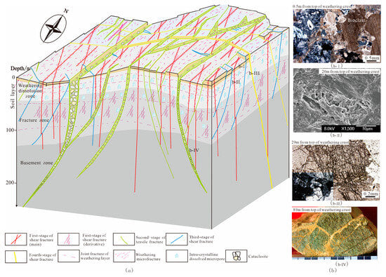
Figure 11.
Reservoir model of Pre-Cenozoic basement weathering crust in Lishui Sag.Notes: (a) Distribution pattern of buried hill reservoir; (b) Typical photographs; (b-I) Well W3, 1873 m, soil layer characteristics; (b-II) Well W2, 3620 m, Granite, feldspar alteration pores; (b-III) Well W1, 2279 m, Granite, feldspar shear fractures; (b-IV) Well L1, 2589.85 m, Cataclastic gneiss.
According to the temperature and pressure conditions for tectonic fracture formation, the Lingfeng buried hill zone is more favorable for fracture formation than the Xianqiao structural zone. Based on imaging logging data, the average linear density of gneiss in well L1 was 1.4 per meter, while that of granite in well W2 was 2.5 per meter. Considering that the temperature and pressure environment in well W2 was less favorable for fracture formation than that in well L1, we can conclude that granite produces more fractures under unfavorable conditions than gneiss under favorable conditions. We speculate that the granite distributed in the Lingfeng buried hill zone under a favorable environment for fracture formation is the most promising for high-quality reservoirs. Therefore, the granite in the Lingfeng buried hill zone, particularly the area of cataclastic granite, is favorable for exploring the basement weathering reservoirs in the Lishui Sag.
8. Conclusions
- (1)
- Secondary fractures (tensile tectonic fractures, shear tectonic fractures, weathering fractures, and alteration fractures) and secondary pores (intragranular alteration pores) are developed in the Pre-Cenozoic basement of Lishui Sag. Tensile tectonic fractures are the main type of fracture reservoir space. The reservoirs are characterized by low porosity, low permeability, and small pore diameter, and the physical properties of granite reservoirs are better than those of gneiss reservoirs.
- (2)
- Pre-Cenozoic basement reservoirs in Lishui Sag are dominated by low porosity and permeability, and the physical properties of granite reservoirs are better than those of gneiss reservoirs. Fragmentation can significantly improve the physical properties of rocks. The pore diameter of gneiss is smaller than that of granite. The weathering crust can be divided vertically into the soil layer, weathering dissolution zone, weathering fracture zone, and bedrock zone. The thickness of the weathering fracture zone can reach 122 m, providing good conditions for fracture reservoir formation.
- (3)
- There are four stages of tectonic fractures in the study area: Yandang movement shear fractures, Paleocene tensile tectonic fractures, Huagang movement shear fractures, and Longjing movement shear fractures. The Lingfeng buried hill zone and Xianqiao structural zone show differences in the main stage of basement fracture formation. The main factors controlling differential fracture formation are the coupling between the uplifted and exposed basement histories, the tectonic stress field, and lithology. Considering the thermal history of the Lingfeng buried hill zone and the Xianqiao structural zone, the granite of the Lingfeng buried hill zone is a favorable area for the formation of basement fracture reservoirs in the Lishui Sag.
Author Contributions
Writing—original draft preparation, J.L.; writing—review and editing, H.T. All authors have read and agreed to the published version of the manuscript.
Funding
This work was supported by the Key Science and Technology Project of Seven-year Action Plan of CNOOC (grant No. CCL2020SHPS018RSI) and Key Research and Development Program of Jilin Province (grant No. 20230203107SF).
Data Availability Statement
Data are contained within the article.
Conflicts of Interest
Jinshui Liu received Seven-year Action Plan funding support from CNOOC. The funding sponsors had no role in the design of the study; in the collection, analyses, or interpretation of data; in the writing of the manuscript, and in the decision to publish the results.
References
- Cuong, T.X.; Warren, J.K. Bach ho field, a fractured granitic basement reservoir, Cuu long basin, offshore se Vietnam: A “buried-hill” play. J. Pet. Geol. 2009, 32, 129–155. [Google Scholar] [CrossRef]
- Newton, R.C.; Touret, J.L.R.; Aranovich, L.Y. Fluids and H2O activity at the onset of granulite facies metamorphism. J. Precambrian Res. 2014, 253, 17–25. [Google Scholar] [CrossRef]
- Xie, Y.H. Gas resources and accumulation model of BZ19-6 Archean buried-hill large-scale gas reservoir in Bozhong Sag, Bohai Bay Basin. J. Pet. Geol. Exp. 2020, 42, 858–866. [Google Scholar] [CrossRef]
- Zhou, X.H.; Wang, Q.B.; Feng, C.; Ye, T.; Liu, X.J.; Hao, Y.W.; Zhou, L. Formation conditions and geological significance of large Archean buried hill reservoirs in Bohai Sea. J. Earth Sci. 2022, 47, 1534–1548. [Google Scholar] [CrossRef]
- Wang, X.; Zhou, X.H.; Xu, G.S.; Liu, P.B.; Gao, K.S.; Guan, D.Y. Characteristics and controlling factors of reservoirs in Penglai 9-1 large-scale oilfield in buried granite hills, Bohai Sea. J. Oil Gas Geology 2015, 36, 262–270. [Google Scholar] [CrossRef]
- Xu, S.L.; You, L.; Mao, X.L.; Zhong, J.; Wu, S.J. Reservoir Characteristics and Controlling Factors of Granite Buried Hill in Songnan Low Uplift, Qiongdongnan Basin. J. Earth Sci. 2019, 44, 2717–2728. [Google Scholar] [CrossRef]
- Xue, Y.A.; Wang, Q.; Niu, C.M.; Miao, Q.H.; Liu, M.X.; Yin, J. Hydrocarbon charging and accumulation of BZ 19-6 gas condensate field in deep buried hills of Bozhong Depression, Bohai Sea. J. Oil Gas Geol. 2020, 41, 891–902. [Google Scholar] [CrossRef]
- Dai, X.; Tang, H.; Li, H.; Zhang, Y.; Xu, P.; Wang, P.; Song, G.; Du, X. Characteristics and formation mechanism of the fractures in Archaean buried hill: A case study in the BZ19-6 Block, Bohai Bay Basin, China. Geol. J. 2021, 56, 2240–2257. [Google Scholar] [CrossRef]
- Hou, M.C.; Cao, H.Y.; Li, H.Y.; Chen, A.Q.; Wei, A.J.; Chen, Y.; Ye, T. Characteristics and controlling factors of deep buried-hill reservoirs in the BZ19-6 structural belt, Bohai Sea area. J. Nat. Gas Ind. 2019, 39, 33–44. [Google Scholar] [CrossRef]
- Hu, Z.W.; Xu, C.G.; Yang, B.; Huang, Z.; Su, W. Reservoir forming mechanism of Penglai 9-1 granite buried-hills and its oil geology significance in Bohai Sea. J. Acta Pet. Sin. 2017, 38, 274–285. [Google Scholar] [CrossRef]
- Novikov, V.M.; Boeva, N.M.; Bortnikov, N.S.; Zhukhlistov, A.P.; Krupskaya, V.V.; Bushueva, E.B. Chai Mat Kaolin–Bauxite Deposit (South Vietnam): Typomorphic Features of Kaolinite and Formation Mechanism of the Zonal Profile of the Bauxite-Bearing Weathering Crust of Granites. J. Geol. Ore Depos. 2018, 60, 513–526. [Google Scholar] [CrossRef]
- Ceccato, A.; Viola, G.; Tartaglia, G.; Antonellini, M. In–situ quantification of mechanical and permeability properties on outcrop analogues of offshore fractured and weathered crystalline basement: Examples from the Rolvsnes granodiorite, Bømlo, Norway. J. Mar. Pet. Geol. 2021, 124, 104859. [Google Scholar] [CrossRef]
- Liu, Z.; Zhu, M.L.; Liu, H.M.; Li, X.K.; Liang, C.Z.; Gong, J.Q.; Zhang, P.F. Formation mechanism and distribution characteristics of granite weathering crust reservoir: A case study of the western segment of the northern belt of Dongying sag. J. Acta Pet. Sin. 2021, 42, 163–175. [Google Scholar]
- Xi, S.L.; Zheng, C.B.; Xia, R.Y. Geochemical model of compaction released water karst in the ordovician of Ordos Basin. J. Acta Sedimentol. Sin. 2005, 23, 354–360. [Google Scholar]
- Zhang, J.T.; Jin, X.H.; Li, S.J.; Li, W.; Sun, Y.P. Types and origin of pore-fillings from the 5th member of the Ordovician Majiagou Formation in Ordos Basin. J. Oil Gas Geol. 2016, 37, 684–690. [Google Scholar] [CrossRef]
- Xia, Y.; Deng, H.C.; Wang, Y.Y.; He, J.H.; Jie, X.H.; Teng, J. Development characteristics and formation stages of natural fractures of the Triassic Leikoupo Formation in Pengzhou area of Western Sichuan Basin. J. Mar. Orig. Pet. Geol. 2021, 26, 81–89. [Google Scholar] [CrossRef]
- Dong, M.; Guo, W.; Zhang, L.Y.; Wu, Z.H.; Ma, L.C.; Dong, H.; Yang, Y.H. Characteristics of paleotectonic stress field and fractures of WufengLongmaxi Formation in Luzhou area, southern Sichuan Basin. J. Lithol. Reserv. 2022, 34, 43–51. [Google Scholar] [CrossRef]
- Luo, T.; Guo, X.W.; Shu, Z.G.; Bao, H.Y.; He, S.; Tan, Z.J.; Xiao, Z.H. Fluid source and formation time of fracture veins of Wufeng Formation and Longmaxi Formation in the south of Jiaoshiba area, Sichuan Basin. J. Acta Pet. Sin. 2021, 42, 611–622. [Google Scholar] [CrossRef]
- Feng, X.J.; Cai, D.S.; Wang, C.X.; Gao, L. The meso-cenozoic tectonic evolution in east China sea shelf basin. J. China Offshore Oil Gas 2003, 17, 35–39, (In Chinese with English Abstract). [Google Scholar]
- Zhu, W.L.; Mi, L.J.; Zhang, H.H. Atlas of Oil and Gas Basins, China Sea; Petroleum Industry Pressing: Beijing, China, 2010; pp. 68–72. [Google Scholar]
- Suo, Y.H.; Li, S.Z.; Zhao, S.J.; Somerville, I.D.; Yu, S.; Dai, L.M.; Xu, L.Q.; Cao, X.Z.; Wang, P.C. Continental margin basins in East Asia: Tectonic implications of the Meso-Cenozoic East China Sea pull-apart basins. Geol. J. 2015, 50, 139–156. [Google Scholar] [CrossRef]
- Wang, Q.; Wyman, D.A.; Li, Z.X.; Bao, Z.W.; Zhao, Z.W.; Zhao, Z.H.; Wang, Y.X.; Jian, P.; Yang, Y.H.; Chen, L.L. Petrology, geochronology and geochemistry of ca. 780Ma A-type granites in South China: Petrogenesis and implications for crustal growth during the breakup of the supercontinent Rodinia. J. Precambrian Res. 2010, 178, 185–208. [Google Scholar] [CrossRef]
- Li, Z.X.; Li, X.H.; Chung, S.L.; Lo, C.H.; Xu, X.S.; Li, W.X. Magmatic switch-on and switch-off along the South China continental margin since the Permian: Transition from an Andean-type to a Western Pacific-type plate boundary. J. Tectonophys. 2012, 532–535, 271–290. [Google Scholar] [CrossRef]
- Wan, T.F.; Zhao, Q.L. The genesis of tectono-magmatism in eastern China. J. Sci. Sin. (Terrae) 2012, 42, 155–163, (In Chinese with English Abstract). [Google Scholar] [CrossRef]
- Li, J.H.; Zhang, Y.Q.; Dong, S.W.; Johnston, S.T. Cretaceous tectonic evolution of South China: A preliminary synthesis. J. Earth-Sci. Rev. 2014, 134, 98–136. [Google Scholar] [CrossRef]
- Li, W.X.; Zhou, X.M. Late Mesozoic subduction zone of southeastern China. Geol. J. China Univ. 1999, 5, 45–50, (In Chinese with English Abstract). [Google Scholar]
- Zhou, X.M.; Li, W.X. Origin of Late Mesozoic igneous rocks in Southeastern China: Implications for lithosphere subduction and underplating of mafic magmas. J. Tectonophys. 2000, 326, 269–287. [Google Scholar] [CrossRef]
- Bas, M.J.; Streckeisen, A.L. The IUGS systematics of igneous rocks. J. Geol. Soc. 1991, 148, 825–833. [Google Scholar] [CrossRef]
- Chen, M.Y.; Jin, W.; Zheng, C.Q. Identification Manual of Metamorphic Rocks; Geological Publishing House: Beijing, China, 2009; pp. 26–31. [Google Scholar]
- Wu, H.C.; Zhang, T.; Tang, H.F.; Lu, B.L.; Dong, Z. Integrated Identification of Lithology Using Seismic and Magnetic Anomaly Data for Granite and Gneiss Basement: A Case Study of the LiShui Depression in the East China Sea Basin. J. Miner. 2023, 13, 507. [Google Scholar] [CrossRef]
- Hu, J.S.; Jiang, Y.M.; Tang, H.F.; Ma, W.R.; Tao, P.; Sun, N.Y. Quantitative characterization of vertical zonation of Mesozoic granite weathering reservoirs in the coastal area of eastern Fujian Province, China. J. Pet. Sci. 2023, 20, 2664–2682. [Google Scholar] [CrossRef]
- SY/T5336-2006; Practice for Core Analysis. The Standardization Administration of the People’s Republic of China: Beijing, China, 2006.
- SY/T6490-2014; Specification for Measurement of Rock NMR Parameter in Laboratory. The Standardization Administration of the People’s Republic of China: Beijing, China, 2014.
- Lai, J.; Wang, G.W.; Sun, S.M.; Jiang, C.; Zhou, L.; Zheng, X.H. Research advances in logging recognition and evaluation method of fractures in tight sandstone reservoirs. J. Prog. Geophys. 2015, 30, 1712–1724, (In Chinese with English Abstract). [Google Scholar]
- Huang, J.X.; Peng, S.M.; Wang, X.J.; Xiao, K. Applications of imaging logging data in the research of fracture and ground stress. J. Acta Pet. Sin. 2006, 27, 65–69. [Google Scholar] [CrossRef]
- Mclennan, S.M. Weathering and global denudation. J. Geol. 1993, 101, 295–303. [Google Scholar] [CrossRef]
- Shao, J.Q.; Yang, S.Y. Does chemical index of alteration (CIA) reflect silicate weathering and monsoonal climate in the Changjiang River basin? J. Chin. Sci. Bull. 2012, 57, 933–942. [Google Scholar] [CrossRef]
- Xu, C.G.; Shao, L.Y. Limiting factors in utilization of chemical index of alteration of mudstones to quantify the degree of weathering in provenance. J. Palaeogeogr. 2018, 20, 515–522, (In Chinese with English Abstract). [Google Scholar] [CrossRef]
- Tang, H.F.; Tian, Z.W.; Gao, Y.F.; Dai, X.J. Review of volcanic reservoir geology in China. J. Earth-Sci. Rev. 2022, 232, 104158. [Google Scholar] [CrossRef]
- SY/T 6285-2011; Evaluating methods of oil and gas reservoirs. The Standardization Administration of the People’s Republic of China: Beijing, China, 2011.
- Uyeda, S. Comparative Subductology. Int. Union Geol. Sci. 1983, 6, 19–24. [Google Scholar] [CrossRef]
- Tapponnier, P.; Peltzer, G.; Armijo, R. On the mechanics of the collision between India and Asia. J. Geol. Soc. Lond. Spec. Publ. 1986, 19, 113–157. [Google Scholar] [CrossRef]
- Watson, M.P.; Hayward, A.B.; Parkinson, D.N. Plate tectonic history, basin development and petroleum source rock deposition onshore China. J. Mar. Pet. Geol. 1987, 4, 205–225. [Google Scholar] [CrossRef]
- Northrup, C.J.; Royden, L.H.; Burchfiel, B.C. Motion of the Pacific plate relative to Eurasia and its potential relation to Cenozoic extension along the eastern margin of Eurasia. J. Geol. 1995, 23, 719–722. [Google Scholar] [CrossRef]
- Li, T.D.; Mo, J. Tectonic framework of the west circum-Pacific tectonic tract and the geological evolution of the East China Sea. J. Mar. Geol. Quat. Geol. 2002, 22, 1–6. [Google Scholar] [CrossRef]
- Shu, L.S.; Zhou, X.M. Late Mesozoic tectonism of southeast China. J. Geol. Rev. 2002, 48, 249–260. [Google Scholar] [CrossRef]
- Zhang, K.X.; Wang, G.C.; Ji, J.L.; Song, B.W.; Zhang, J.Y.; Liang, Y.P.; Luo, M.S.; Kou, X.H.; Wang, Y.M.; Xu, D.; et al. Paleogene-Neogene stratigraphic realm and sedimentary sequence of the Qinghai-Tibet Plateau and their response to uplift of the plateau. J. Sci. China (Earth Sci.) 2010, 53, 1271–1294. [Google Scholar] [CrossRef]
- Zhong, D.L.; Ding, L. Rising process of the Qinghai-Xizang (Tibet) Plateau and its mechanism. J. Sci. China Ser. D 1996, 39, 369–379. [Google Scholar]
- Sdrolias, M.; Roest, W.R.; Müller, R.D. An expression of Philippine Sea plate rotation: The Parece Vela and Shikoku Basins. J. Tectonophys. 2004, 394, 69–86. [Google Scholar] [CrossRef]
- Clark, M.K.; Farley, K.A.; Zheng, D.; Wang, Z.; Duvall, A.R. Early Cenozoic faulting of the northern Tibetan Plateau margin from apatite (U–Th)/He ages. J. Earth Planet. Sci. Lett. 2010, 296, 78–88. [Google Scholar] [CrossRef]
- Wang, G.C.; Cao, K.; Zhang, K.X.; Wang, A.; Liu, C.; Meng, Y.N.; Yadong, X.U. Spatio-temporal framework of tectonic uplift stages of the Tibetan Plateau in Cenozoic. J. Sci. China (Earth Sci.) 2011, 54, 29–44. [Google Scholar] [CrossRef]
- Zhang, G.H.; Zhang, J.P. A discussion on the tectonic inversion and its genetic mechanism in the East China Sea Shelf Basin. J. Earth Sci. Front. 2015, 22, 260–270. [Google Scholar] [CrossRef]
- Suppe, J. Kinematics of arc-continent collision, flipping of subduction, and back-arc spreading near Taiwan. J. Mem. Geol Soc China 1984, 6, 21–33. [Google Scholar]
- Xu, W.L.; Le, J.Y. Tectonic movement and evolution of the East China Sea. J. Mar. Geol. Quat. Geol. 1988, 8, 9–21, (In Chinese with English Abstract). [Google Scholar]
- Seno, T.; Stein, S.; Gripp, A.E. A model for the motion of the Philippine Sea Plate consistent with NUVEL-1 and geological data. J. Geophys. Res. Solid Earth 1993, 98, 17941–17948. [Google Scholar] [CrossRef]
- Huang, P.H.; Su, W.J.; Chen, J.B. Seismicity and stress field in Okinawa Trough and Ryukyu regions. J. Acta Seismol. Sin. 1994, 7, 513–520. [Google Scholar] [CrossRef]
- Liu, J.S.; Xu, H.Z.; Jiang, Y.M.; Wang, J.; He, X.J. Mesozoic and Cenozoic basin structure and tectonic evolution in the East China Sea basin. J. Acta Geol. Sin. 2020, 94, 675–691, (In Chinese with English Abstract). [Google Scholar]
- Browning, J.; Meredith, P.; Gudmundsson, A. Cooling-dominated cracking in thermally stressed volcanic rocks. J. Geophys. Res. Lett. 2016, 43, 8417–8425. [Google Scholar] [CrossRef]
- Wu, J.W.; Chen, S.P. Effect of Heating and Cooling on Thermal Cracking of Granite under Unconstrained Conditions. Chin. J. Undergr. Space Eng. 2019, 15, 108–115, (In Chinese with English Abstract). [Google Scholar]
Disclaimer/Publisher’s Note: The statements, opinions and data contained in all publications are solely those of the individual author(s) and contributor(s) and not of MDPI and/or the editor(s). MDPI and/or the editor(s) disclaim responsibility for any injury to people or property resulting from any ideas, methods, instructions or products referred to in the content. |
© 2024 by the authors. Licensee MDPI, Basel, Switzerland. This article is an open access article distributed under the terms and conditions of the Creative Commons Attribution (CC BY) license (https://creativecommons.org/licenses/by/4.0/).