Abstract
This research quantifies the health risks associated with exposure to heavy metals in the Matjhabeng Local Municipality, a gold mining region in South Africa, utilising a deterministic source–pathway–receptor approach. This study uniquely integrates both non-carcinogenic and carcinogenic risk assessments across multiple heavy metals, providing a comprehensive perspective on health impacts in mining-impacted communities. The study measured concentrations of arsenic (As), cadmium (Cd), lead (Pb), cobalt (Co), chromium (Cr), copper (Cu), iron (Fe), nickel (Ni), selenium (Se), and zinc (Zn) in soil samples, with mean values found to be 3.2 mg/kg, 2.5 mg/kg, 45 mg/kg, 17 mg/kg, and 25 mg/kg for As, Cd, Pb, Co, and Cr, respectively. The deterministic assessment revealed minimal non-carcinogenic risks for ingestion across all demographics (HQ < 1), while significant dermal risks were identified for Cd, Pb, Co, and Cr (HQ > 1), particularly for the adult group. The inhalation pathway emerged as a critical exposure route, with HQ values ranging from 5 to 15 and chronic hazard index values significantly exceeding safe limits (CHI > 5). The carcinogenic risk through inhalation notably surpassed the acceptable thresholds set by the United States Environmental Protection Agency (1 × 10⁻⁴ to 1 × 10⁻⁶), with a calculated lifetime cancer risk far exceeding the limit for As, Cd, Cr, Co, and Ni for both adults and juveniles. These findings underscore the urgent need for targeted risk mitigation strategies in the community to address the significant health risks posed by airborne heavy metal exposure.
1. Introduction
Gold mining in South Africa began in earnest in 1886 with operations concentrated along the Witwatersrand Basin, marking a significant period in the nation’s industrial history [1,2]. By the late 18th century, the mining landscape had transformed dramatically due to the depletion of easily accessible ore and the resultant need for advanced extraction technologies [3,4]. This shift prompted the exploration and development of new mining areas beyond the central Witwatersrand, including regions like the Free State, the Far West Rand, and Evander, driven by escalating costs and the decreasing yield of traditional mines [3,5]. In 1946, the discovery of gold in the Free State province led to the development of the Matjhabeng Local Municipality, now a notable historical mining district. This area, including the towns of Welkom, Virginia, and Odendaalsrus, became integral to supporting the expanding mining operations. The extensive mining activities in this region have resulted in substantial gold mine tailings (including legacy sites), which are a major environmental concern due to their significant and ongoing contribution to soil pollution [6,7,8].
Soils act as major reservoirs for heavy metals discharged into the environment, primarily from mine tailings and ongoing mining operations [9]. The accumulation of these metals can persistently impair soil quality, altering properties such as texture and nutrient availability, with significant long-term ecological consequences [9,10,11]. In particular, the soils of the Witwatersrand goldfields around the Gauteng province have been the subject of extensive research, revealing levels of heavy metals that not only surpass local baseline soil values but also exceed multiple soil quality guidelines [12,13,14,15,16]. These soils are predominantly acidic, with average pH values ranging from 4.5 to 5.5, which can enhance the mobility and bioavailability of toxic metals such as arsenic and lead. Additionally, the organic matter content in these soils is generally low, often less than 2%, which further affects the retention and availability of these metals. The combination of acidic conditions and low organic matter significantly increases the risk of heavy metal uptake by plants and their subsequent entry into the food chain, posing heightened health risks to local communities. Despite extensive research on the soils of the Witwatersrand goldfields around the Gauteng province, revealing levels of heavy metals that not only surpass local baseline soil values but also exceed multiple soil quality guidelines [12,13,14,15,16], there remains a noticeable lack of comprehensive health risk studies specifically for the Free State, particularly within the Matjhabeng mining area.
This study addresses this gap by employing a refined source–pathway–receptor approach and adhering to the prescribed United States Environmental Protection Agency (USEPA) standard health risk assessment protocols [17]. The steps used to calculate the health risks upon exposure to heavy metals in the area included hazard identification, exposure and dose–response evaluation, toxicity assessment, and risk characterisation, providing a thorough framework for understanding the health implications of heavy metal exposure in the Matjhabeng mining area. A deterministic approach was chosen for calculating human health risks due to its straightforward application and utility in providing precise, specific estimates of risks, based on predefined exposure scenarios. This method simplifies complex environmental exposures into single average or representative values for factors such as concentration, exposure duration, and frequency. However, the limitations of using deterministic methods for calculating health risks include a lack of variability and uncertainty analyses, leading to underestimation or overestimation of actual risks. Deterministic methods do not account for the variability in individual sensitivities and exposures that occur in an actual population, nor do they typically address the cumulative uncertainty inherent in each step of the risk assessment process. This can result in less comprehensive risk management decisions, as the method assumes uniform exposure and response across all individuals. Our novel contribution lies in the detailed mapping and quantitative analysis of soil contamination levels across the Matjhabeng mining area, coupled with a thorough evaluation of both carcinogenic and non-carcinogenic risks, utilising a deterministic methodology. This approach enhances the precision of risk estimates and provides new insights into the spatial distribution of heavy metal contamination, enabling targeted mitigation strategies.
This study is among the first to map the spatial distribution of heavy metals in the Matjhabeng mining area and to correlate these findings with health risk assessments, providing a model for other regions with similar environmental challenges. By enhancing existing human health risk assessment methods, this approach aimed at developing more efficient and cost-effective strategies for managing soil pollution. Ultimately, the insights gained could guide the implementation of robust management practices designed to safeguard public health and improve the overall well-being of communities residing in mining-impacted areas.
2. Materials and Methods
2.1. Study Area and Sources of Heavy Metal Contamination in Soils and Transfer Pathways
The study was conducted in the Matjhabeng mining area, located within the Lejweleputswa District Municipality in the north-eastern part of the Free State province, South Africa. The Matjhabeng mining area is part of the extensive Witwatersrand Basin, a region with a long history of gold mining. Covering an area of 5156 km2, Matjhabeng mining area has a population of 406,461, yielding a density of 83.18 people per km2 [18]. The geology of Matjhabeng mining area is characterised by formations from the Ventersdorp Supergroup, Witwatersrand Supergroup, and Karoo Supergroup [19]. The topography of the area is predominantly flat, sitting at an elevation of about 1435 m above sea level, and features rolling plains interspersed with low hills, including the notable Koppie Alleen.
Seasonal wind conditions are a significant factor in the area, particularly during the months of August to October. During this period, frequent windstorms are capable of mobilising dust particles smaller than or equal to 20 µm, which often contain heavy metals from the gold mine tailings. These dust episodes play a crucial role in the dispersal of contaminants, posing both non-carcinogenic and carcinogenic risks to the local population through inhalation and ingestion [20]. Wind and Weather Statistics from Welkom Airport (2011–2018) [21] indicated that winds predominantly blow from the north/northeast (NNE) towards the south/southwest (SSW), with a 12.1% frequency during this time [21].
Gold mining remains the principal economic activity in Matjhabeng mining area, with tailings from these operations being primary sources of soil contamination. Additionally, various land uses, including residential developments, industrial sites such as breweries, wastewater treatment facilities, abattoirs, and agricultural enterprises, contribute to heavy metal pollution in the soil [22,23]. The Matjhabeng mining area experiences diverse anthropogenic activities that lead to diffused pollution sources and contribute to soil contamination. This contamination can be transported by runoff water during rainfall from mine tailings and other anthropogenic sources. Moreover, wind, rainwater infiltration, and percolation also facilitate the transfer of heavy metals to the soils, enhancing the spread of these contaminants [24,25]. Events such as tailings dam leaks or collapses pose additional risks of soil contamination [26].
2.2. Sampling Sites
In determining the locations for sample collection, the methodology employed was designed to mirror the site selection procedures outlined by Belle et al. [23,27]. Sampling sites were strategically chosen based on the proximity to mines and mine tailings, as well as the presence of significant anthropogenic activities such as industrial operations and agricultural practices. The patterns of prevailing winds were also factored into the site selection to assess potential pathways for airborne dispersion of contaminants.
A total of fifteen sampling sites were established across six towns within the Matjhabeng mining area, including Welkom, Virginia, Allanridge, Hennenman, Odendaalsrus, and Bronville, with an additional section in Bultfontein (refer to Figure 1). In the heart of Matjhabeng mining area, seven sites—labelled S1 through S7—were concentrated in zones heavily impacted by mining activities and the presence of tailings. In Virginia, three sites (S8, S9, and S10) were identified about 5–7 km from the mining and tailings zones, representing areas slightly removed from direct mining influence.
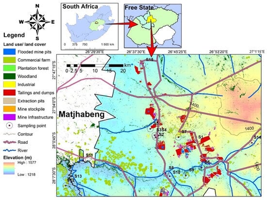
Figure 1.
Study area of the Matjhabeng Local Municipality, showing the fifteen sampling sites.
Further afield, three additional sites—S11, S12, and S13—were set up to encompass parts of Welkom and the town of Bultfontein, positioned approximately 30–37 km from the nearest mines and tailings, capturing a broader environmental impact scope. These locations were specifically chosen along the trajectory of the prevailing wind direction to better understand the transport of pollutants from the source areas.
For comparative purposes, two control sites, S14 and S15, were established against the predominant wind direction. Site S14 was in Hennenman, approximately 10–12 km east of the primary mining and tailing zones, within a region predominantly used for agriculture, including crop farming and livestock rearing. Site S15 was situated to the north, around 10–12 km away from the nearest mining and tailings sites, offering additional insights into the dispersion of contaminants relative to wind patterns.
2.3. Soil Sample Collection and Preparation
Soil samples were systematically gathered from the fifteen designated sites within the study area, adhering to a refined sampling protocol adapted from Mahlangeni et al. [28]. At each site, approximately 500 g of soil was extracted from a depth of 15 cm and secured in individually labelled zip-seal polyethylene bags to prevent contamination. The soil samples were transported to the laboratory facilities at the Central University of Technology in Bloemfontein, Free State, for initial pretreatment processes, where the samples were first dried in an oven at 40 °C for 48 h to remove moisture. Subsequently, they were finely ground with a porcelain mortar and pestle to achieve a consistent particle size and then sieved through a 2 mm stainless steel sieve with a silicon handler to ensure uniform granularity [29]. After processing, the soil samples were placed in zip-sealed plastic bags and stored under controlled conditions until they were ready for further analytical procedures.
2.4. Measurement of Heavy Metals in Soil
The analysis of heavy metal concentrations in the soil samples focused on ten metals—As, cadmium (Cd), lead (Pb), Co, Cr, Cu, iron (Fe), Ni, selenium (Se), and Zn—which are commonly associated with mining activities. These determinations were carried out using inductively coupled plasma optical emission spectrometry (ICP–OES) at the School of Physics and Chemistry, University of KwaZulu-Natal, Westville campus.
Prior to the ICP–OES analysis, the soil samples underwent a rigorous preparation process involving a modified open vessel digestion method in nitric acid (HNO3), adapted from protocols established by Wong [29]. Specifically, each pretreated powdered soil sample, weighing 0.25 g, was placed into a 100 mL beaker. To these samples, 10 mL of concentrated HNO3 was added. The samples were then carefully covered with a watch glass to ensure complete dissolution of the soil and full recovery of the heavy metals while also preventing the loss of any volatile elements. This mixture was digested on a hot plate located under a fume hood to ensure the safety and containment of potentially harmful vapours.
Following digestion, the solutions were filtered using Whatman No. 1 filter paper into a 25 mL volumetric flask, diluted with double-distilled water, and subsequently stored in polyethylene bottles until they were analysed.
2.5. Data Analysis
In this study, a comprehensive human health risk assessment was conducted to evaluate the potential health risks associated with exposure to heavy metals in the soils of the Matjhabeng mining area. This assessment utilised a methodological approach that integrates the source–pathway–receptor process with the established protocols outlined by the USEPA [17] and the South African Framework for the Management of Contaminated Land [30]. The assessment process encompassed several critical steps: hazard identification; exposure and dose–response evaluation; toxicity assessment, which included the characterisation of the toxicity of the contaminants; and risk characterisation, involving the quantitative estimation of the risk to human health.
The analysis specifically calculated the health risks associated with both carcinogenic and non-carcinogenic contaminants present in the environment. This dual focus allowed for a more detailed understanding of the varied impacts that these contaminants may have on public health within the study area.
To validate the analytical procedure, we used certified reference materials (CRMs) D081–540 for soil (D081–540, Golden, CO, USA). All samples were analysed in triplicate (n = 3), and standards were also prepared to validate the digestion method.
2.5.1. Hazard Identification and Potential Sources of Heavy Metals in Matjhabeng Mining Area
The hazard identification phase in this study involved pinpointing chemicals within the environment that could potentially pose health risks to humans exposed to elevated levels of contamination, as well as the potential sources of these heavy metals in the Matjhabeng mining area. In the Matjhabeng mining area, these chemicals specifically included toxic heavy metals present in the soil, which are known to have adverse health effects. The primary hazards identified were high concentrations of particularly hazardous metals such as As, Cd, and Pb [22]. Additionally, other metals including Co, Cr, Cu, Fe, Ni, Se, and Zn were also detected and evaluated due to their potential to contribute to health risks in local communities [22]. On the other hand, the potential sources of these heavy metals in the Matjhabeng mining area could largely be attributed to both the point sources and non-point sources arising from various sectors, such as mining and mine tailings, industries, and agricultural activities, which release pollutants into the environment [22].
2.5.2. Exposure Assessment and Pathways through Which Individuals Are Exposed to Heavy Metals in the Environment
The exposure assessment conducted in this study aimed at quantifying the concentrations of heavy metals to which the local population in the Matjhabeng mining area has been exposed to throughout their lives. This assessment also specifies the pathways (oral, dermal, and inhalation) through which individuals are exposed to heavy metals in the environment. The primary routes of exposure to these heavy metals in the environment include ingestion, inhalation, and dermal absorption [14]. Residents in the Matjhabeng mining area may encounter heavy metals through several mechanisms: inhaling dust particles laden with heavy metals, consuming contaminated soil, vegetables, fruit, and food crops, and through skin contact with contaminated soil and dust.
To evaluate the extent of exposure, the average daily intake (ADI) of heavy metals was calculated. The ADI represents the estimated amount of heavy metals ingested, inhaled, or absorbed through the skin per day, normalised to body weight (mg/kg/day). This calculation helps to determine the potential health risks associated with long-term exposure to these contaminants [14,31]. The specific formulas used for calculating the ADI [14] included considerations for different exposure scenarios tailored to the lifestyle and environmental conditions of the Matjhabeng mining community.
Ingestion of heavy metals is calculated using the following equation:
where ADIing is the average daily intake of heavy metals ingested from soil in mg/kg/day, C is the concentration of heavy metals in mg/kg in soil, IR in mg/kg/day is the ingestion rate, EF in days/year is the exposure frequency, ED is the exposure duration in years, CF is the conversion factor in mg/kg, BW is the body weight of the exposed individual in kilograms, and AT is the time period over which the dose is averaged in days.
Inhalation of heavy metals is calculated using the following equation:
where ADIinh is the average daily intake of heavy metals inhaled from soil in mg/kg/day, CS is the concentration of heavy metals in soil in mg/kg, IRair is the inhalation rate in m3/day, EF is the exposure frequency in days per year, ED is the exposure duration in years, BW is the body weight of the exposed individual in kilograms, AT is the time period over which the dose is averaged in a day, and PEF is the particulate emission factor in m3/kg.
Dermal contact with heavy metals is calculated using the following equation:
where ADIdems is the exposure dose through dermal contact of heavy metals from soil in mg/kg/day, CS is the concentration of heavy metals in soil in mg/kg, SA is exposed skin area in cm2, FE is the fraction of the dermal exposure ratio to soil, AF is the soil adherence factor in mg/cm2, and ABS is the fraction of the applied dose absorbed across the skin. EF, ED, CF, BW, AT, and PEF are defined as in the previous equations. The exposure parameters used to calculate the health risk assessment are presented in Table 1 and were obtained from the South African Framework for the Protection of Contaminated Land [30], as well as Kamunda et al. [14].

Table 1.
Exposure parameters used for the health risk assessment through different exposure pathways for soil.
2.5.3. Characterisation of Risk on Receptors of Pollution
Risk characterisation is a crucial phase that synthesises data from hazard identification, exposure assessment, and dose–response analysis to elucidate the impact of heavy metals on human health within the contaminated environment of the Matjhabeng mining area. This integrative approach provides a comprehensive overview of the potential health risks posed by heavy metals, aiding in the formulation of conclusive insights into the extent of public health threats [14,17,30]. Here, an estimation of the risk is quantified to determine the probability of occurrence of a potential adverse effect from exposure of heavy metals on human health.
The findings from this phase are carefully structured to convey how the local population has been impacted by the pollution. Specifically, the risk characterisation assesses both the carcinogenic and non-carcinogenic risks to which the residents have been exposed. These assessments help delineate the severity of the health risks and guide subsequent public health interventions and policymaking aimed at mitigating these risks [14,17,30].
- Non-carcinogenic risk
The assessment of non-carcinogenic risks from heavy metals involves comparing the exposure levels or ADI of these metals across various exposure pathways to established toxicity thresholds, known as reference doses (RfDs). This comparison is crucial in determining the potential health risks from non-carcinogenic effects due to exposure to contaminated soils. If the ratio of ADI of a particular heavy metal is equal to or less than the RfD, then the risk upon exposure of the heavy metals to human health will be minimal, but when ADI is above the RfD, it may pose a human health risk.
To quantify these risks, the HQ is calculated for each heavy metal—As, Cd, Pb, Co, Cr, Cu, Fe, Ni, Se, and Zn. The HQ is a critical metric that indicates the ratio of the potential exposure to the substance to the level at which no adverse effects are expected. If the HQ exceeds 1, it suggests a potential risk of non-carcinogenic effects on human health from the exposure to the respective heavy metal. The HQ, which is a measure of the ratio of the concentration of ADI and the RfD, was computed in the following manner [32,33]:
where HQ is the hazard quotient, ADI is the average daily intake of heavy metals through the different exposure pathways per day, and RfD is the reference dose.
- Chronic hazard index
The chronic hazard index (CHI) is utilised to assess the combined non-carcinogenic health risks associated with simultaneous exposure to multiple heavy metals within a given sample [7]. This index is calculated by summing the HQ for each detected heavy metal in the soil samples—specifically As, Cd, Pb, Co, Cr, Cu, Fe, Ni, Se, and Zn—at each sampling site.
The CHI provides a cumulative measure of potential health risks, reflecting the aggregate exposure level relative to the toxicity thresholds for each metal. A higher CHI value indicates a greater likelihood of adverse health effects, underscoring the importance of considering combined exposures in risk assessments. The following formula was used to calculate the CHI, as described by Singh and Kumar [34], and facilitates this comprehensive evaluation of risk factors and their potential impact on human health.
CHI is the chronic hazard index for exposure to heavy metals, 1 through I, I represents the HQ of each heavy metal, and HQ is the hazard quotient for the ith heavy metal.
The HQ and CHI values obtained for the different heavy metals were interpreted as follows: HQ and CHI values of less than one (<1) represented no risk of pollutants but values greater than one (>1) indicated a high risk of pollutants with long-term health effects [33,34,35].
- Carcinogenic health risk
Carcinogenic health risk refers to the probability of an individual developing cancer as a result of lifetime exposure to carcinogenic heavy metals. According to the USEPA [17], there is no safe level of exposure to carcinogens; any amount, however small, carries a risk of cancer. This principle underscores the serious nature of even minimal exposure to carcinogenic metals.
To quantitatively assess this risk, the excess lifetime cancer risk was calculated. This involved estimating the probability that an individual will develop cancer over their lifetime due to exposure to specific carcinogenic metals such as As, Cd, Pb, Co, and Cr. The calculation of this risk was based on a formula that incorporates estimated exposure levels and the known carcinogenic potency of each metal [36].
Carcinogenic risk is defined as the probability of an individual developing cancer due to exposure to a carcinogenic heavy metal. The ADI, measured in mg/kg/day, quantifies the daily intake of a heavy metal that can be ingested, inhaled, or absorbed through the skin per kilogram of body weight. The cancer slope factor (CSF), also expressed in mg/kg/day, indicates the likelihood of cancer per unit of chemical intake, quantifying the potency of the carcinogenic heavy metal.
In this study, the assessment of carcinogenic risks was limited to those heavy metals detected in soil samples that also had an established CSF value. The resulting carcinogenic risk levels were categorised as follows:
- A cancer risk below 1 × 10⁻⁶ indicates negligible carcinogenic risks to human health, implying it is not considered a significant health threat.
- A cancer risk within the range of 1 × 10⁻⁶ to 1 × 10⁻⁴ is deemed acceptable, aligning with general health risk standards.
- A cancer risk exceeding 1 × 10⁻⁴ is considered unacceptable, representing a substantial risk for the development of cancer [37].
Both the RfD and CSF values were utilised to calculate the potential non-carcinogenic and carcinogenic risks associated with exposure to heavy metals for both adults and juveniles. These parameters were sourced from recognised studies and guidelines [7,14,30]. The specific RfD values obtained for each metal were as follows: As = 0.003 mg/kg, Cd = 0.0005 mg/kg, Cr = 0.003 mg/kg, Co = 0.02 mg/kg, Cu = 0.037 mg/kg, Pb = 0.0036 mg/kg, Zn = 0.3 mg/kg, Ni = 0.02 mg/kg, and Fe = 0.7 mg/kg.
3. Results
3.1. Quality Assurance
The concentrations and measured values for certified metals are displayed in Table 2. The calibration curves were carefully examined and demonstrated remarkable linearity, displaying an R-squared coefficient of greater than 0.995. The meticulous comparison of the certified concentrations and measured values for certified heavy metals revealed a high level of congruence between the measured values and the certified values, signifying a robust analytical method.
Table 2.
Comparison of experimental values in mg/kg (dry mass) [mean (SD), n = 3] with values for the certified reference materials (elements in soil—D081-540).
3.2. Soil Contamination by Heavy Metals
In this study, all targeted heavy metals were detected in the soil samples. The concentrations followed an increasing order: Fe > Zn > Cu > Ni > Co > Pb > Cr > Se > Cd > As (Figure 2a–d). These concentrations were evaluated against the established background levels of heavy metals in South African soils as reported by Herselman [38], which are Cr (71.9), Cd (0.1), Pb (21.7), Ni (38.7), Zn (45.2), Cu (29.5), and Co (18). For As and Se, the composition estimates of the upper continental crust by Rudnick and Gao [39] were used: As (4.8) and Se (0.09). Additionally, the soil quality guidelines from the Canadian Council of Ministers of the Environment [40] were employed as a comparative measure for Cu (63), Cr (64), Co (50), Pb (140), Cd (10), As (12), Ni (50), Zn (200), and Se (1), which are intended to safeguard environmental and human health.
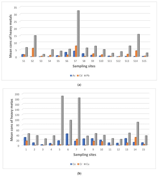
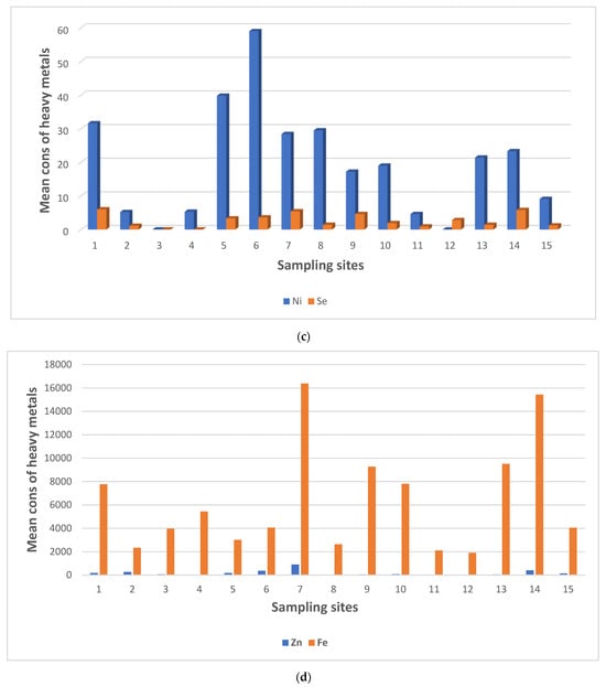
Figure 2.
(a) Mean concentrations (mg/kg) of As, Cd, and Pb in soils from the 15 sampling sites in the Matjhabeng area. (b) Mean concentrations (mg/kg) of Co, Cr, and Cu in soils from the 15 sampling sites in the Matjhabeng area. (c) Mean concentrations (mg/kg) of Ni and Se in soils from the 15 sampling sites in the Matjhabeng area. (d) Mean concentrations (mg/kg) of Zn and Fe in soils from the 15 sampling sites in Matjhabeng.
Analysis of compliance levels with these benchmarks showed that As, Pb, Cr, and Ni generally adhered to background values, with exceptions noted at one site for Pb (S7) and two sites for Ni (S5, S6) which exceeded national soil standards. Contrarily, Cd, Cu, and Se exhibited 100% non-compliance, indicating widespread exceedance of acceptable levels. Zinc also displayed high levels of non-compliance, except in two instances (S4 and S12) where it did not surpass the background concentrations. Notably, Fe showed exceptionally high concentrations, ranging from 1912 mg/kg to 16,390 mg/kg, although no specific background values for Fe in South African soils were available for comparison.
Comparing these findings against the CCME soil quality guidelines [40] revealed broad compliance for As, Cd, Pb, Co, and Cr, with 100% of the samples falling within acceptable limits. However, non-compliance was observed for Zn and Cu in several samples (Zn in S2, S6, S7, S14, and S15; Cu in S5, S6, S7, and S14), indicating exceedance of the CCME guidelines. All samples for Se demonstrated 100% non-compliance with the CCME guidelines, underscoring a significant environmental concern [40].
3.3. Spatial Distribution of Heavy Metals in Soils
The spatial distribution of heavy metals in the soils of the Matjhabeng mining area was analysed and depicted through detailed maps, providing a visual representation of contamination levels across various sampling sites. These maps, showcased in Figure 3, specifically highlight the distribution of significant environmental pollutants, including Cu, Cd, Cr, Pb, As, and Zn, which are known for their potential adverse environmental impacts [34,41,42]. Additional maps were also created for Fe and Se, which were particularly prevalent in the study area.
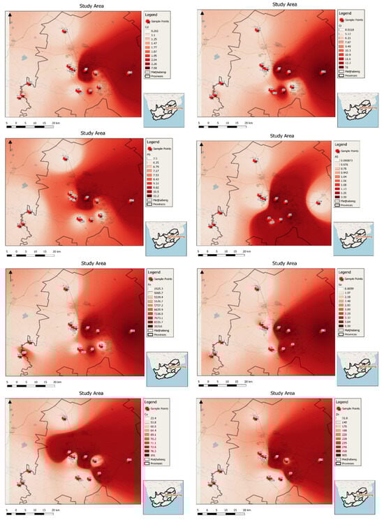
Figure 3.
Spatial distribution for the different heavy metals in soils to denote the level of contamination of the heavy metals in soils within the 15 sampling sites in the Matjhabeng case study area.
The analysis revealed uneven contamination across the sampling sites. The central sites, particularly S1 and S7, displayed the highest levels of contamination for Cd, Cr, Pb, Fe, and Se, reflecting their proximity to multiple mining tailings and active mining operations. Conversely, peripheral sites such as S2, S3, and S4, though still within the vicinity of numerous mine tailings, showed comparatively lower contamination levels.
Variations in contamination were also noted for Cu, Zn, and As. Sites S1, S6, and S7, located close to dense mining activity, exhibited higher contamination levels, whereas sites S2, S3, S4, and S5 showed reduced levels of these metals. The contamination generally decreased further away from the central mining areas. Sites S8, S9, and S10, situated on the eastern side beyond the dense mine tailing zones, demonstrated significantly lower contamination levels, a trend that continued for sites S11, S12, and S13, which are the furthest from the mining centres.
The control sites, positioned on the western side opposite the mining areas, presented interesting contrasts. Site S14, near the Rietspruit Dam—which receives runoff from the Sand River contaminated by mining activities—unexpectedly showed high levels of contamination due to the dam’s frequent overflow, which affects nearby soil. In contrast, control site S15, located to the north and more distant from the mine tailings, registered the least contamination.
3.4. Risk Characterisation on Receptors
3.4.1. Non-Carcinogenic Risk
The non-carcinogenic risk associated with exposure to individual heavy metals was quantified by calculating the HQ for each of the ten heavy metals detected in the soil samples. The HQ provides a measure of risk by comparing the estimated ADI of each metal, obtained through various exposure routes, to its respective RfD. The details of these calculations are outlined in Table 3. The study recorded high ADI values, above the RfD, for all the measured heavy metals in both the juvenile and adult groups when considering the inhalation pathway. The only exceptions were Fe and Se, which did not have an RfD value. This indicates a potential risk to human health from exposure to these heavy metals in inhaled air.
Table 3.
Average daily intake values of heavy metals in mg/kg per day for adults and juveniles of soil for each exposure pathway.
For both adults and juveniles, the ADI values were found to be highest for the inhalation pathway, indicating a greater potential risk from airborne exposure to heavy metals. This was followed by the dermal pathway and, lastly, the ingestion pathway, suggesting that skin contact and ingestion of contaminated soil or dust also contributed to the overall non-carcinogenic risk, albeit to a lesser extent.
The assessment of non-carcinogenic risks is facilitated through the calculation of HQ values, which compare the potential exposure to a safe threshold level. HQ values of less than 1 indicate no significant risk to the health of the local community, while values exceeding 1 may indicate potential for non-carcinogenic effects. According to the study results (Table 4), both adult and juvenile groups showed HQ values below 1 (HQ < 1) for the ingestion pathway, suggesting negligible risk from consuming contaminated soil or dust.
Table 4.
Hazard quotient values for the different exposure routes for adults and juveniles.
Similarly, for the dermal exposure pathway, HQ values remained below 1 for both adults and juveniles, except for Cd, Pb, Co, and Cr in adults, and Co alone in juveniles, where the HQ values exceeded the safe threshold, indicating a potential risk.
Conversely, HQ values for the inhalation pathway were above 1 for both adults and juveniles, highlighting this route as a significant concern for non-carcinogenic effects due to airborne heavy metals in the Matjhabeng mining area. The results underscored that inhalation is the primary pathway contributing to non-carcinogenic risk, followed by dermal contact, while ingestion posed the least risk.
Additionally, the CHI values, which aggregated the HQ values across all pathways, were significantly greater than 1 for both adults and juveniles. These elevated CHI values suggest a substantial non-cancerous health risk from the pervasive heavy metal pollution in the soils of the Matjhabeng mining area, impacting both adult and juvenile residents.
3.4.2. Carcinogenic Risk
This study evaluated the carcinogenic risks posed by exposure to heavy metals, specifically As, Cd, Pb, Cr, and Ni. The analysis focused on cancer risk values resulting from the intake of these metals through the ingestion, inhalation, and dermal pathways for both adults and juveniles. The findings, detailed in Table 5, revealed that the cancer risk values for ingestion were less than 1 × 10⁻⁶, except Co and Ni for the adult and juvenile pathways, respectively, indicating that the carcinogenic risks associated with these pathways are negligible and do not pose a significant health risk.
Table 5.
Carcinogenic risk values for both the adult and juvenile populations.
Conversely, the cancer risk associated with the inhalation of these metals presented a more concerning scenario. Both adults and juveniles in the Matjhabeng mining area exhibited cancer risk values that exceeded the tolerable risk threshold of 1 × 10⁻⁴, as established by the USEPA [17]. This elevated risk underscores the significant potential for health impacts due to inhalation exposure to these carcinogenic metals in the Matjhabeng mining area.
4. Discussion
This study utilised the source–pathway–receptor approach to comprehensively assess the health risks posed by heavy metals in contaminated soils within the Matjhabeng mining area. Non-compliance levels were registered for Cd, Cu, Se, and Zn; depicted mean values were above soil quality limits in the current study. Similarly, in the gold mining sites of Maldon, Victoria, in Australia, soil samples revealed elevated levels of As and toxic heavy metals, including C, Co, Cr, Cu, Hg, Mn, Ni, Pb, and Zn [43]. These levels exceeded the established topsoil standards in Maldon, Victoria, in Australia, as well as the health investigation levels outlined by the National Environmental Protection Measures and the Department of Environment and Conservation of the State of Western Australia [43]. Of particular concern are arsenic and mercury, which were identified as highly toxic to both human health and aquatic ecosystems [43]. Additionally, in the vicinity of a tailings pond in Guangdong, China, high concentrations of heavy metals in the tailings led to the transfer of heavy metals to the surrounding soils, resulting in elevated levels of Pb, Zn, Cu, Cd, Ni, and As in the paddy soil near the tailings dam, surpassing Chinese soil quality standards [44].
Furthermore, the research identified significant non-carcinogenic risks by focusing on ten heavy metals—As, Cd, Pb, Co, Cr, Cu, Fe, Ni, Se, and Zn—particularly through the inhalation pathway. The elevated HQ >1 values for this pathway highlighted substantial risks to both adults and juveniles in the community, suggesting that inhalation of contaminated dust could lead to various health issues [7]. Moreover, the CHI values obtained for all the exposure pathways were notably high. These CHI values, which aggregated the HQ values across all pathways, were significantly greater than 1, with values for Co reaching 5.51 × 10⁶ for adults and 2.57 × 10⁶ for juveniles, respectively. The non-carcinogenic risk values for Cd were 4.84 × 10⁴ for adults and 2.26 × 10⁴ for the juvenile group, thus indicating severe non-carcinogenic risks from such heavy metals. This suggests that direct ingestion of soil, inhalation of dust, and dermal contact with contaminated soil could expose the community to significant health risks. This is particularly concerning for heavy metals such as As, Cd, Pb, Co, Cr, Cu, Ni, and Zn [14].
The findings from the current study align with those from other studies in similar contexts. For instance, research performed in the Carletonville area of the West Wits Line Goldfield in the Witwatersrand Basin highlighted significant health risks due to heavy metal contamination in soils [14]. Findings from this study revealed notably high hazard index values of 2.13 for adults and 43.8 for children, indicating a considerable non-carcinogenic risk to the inhabitants [14], which underscores the persistent risk of exposure to such heavy metals in mining-impacted regions. Similarly, human health risks from exposure to six different metals—As, Cr, Cu, Ni, Pb, and Zn—were assessed in soils in Andhra Pradesh, India, with results showing high hazard index values for Pb in adults and for Cr and Pb in children that exceeded the recommended limit of HI = 1, indicating a non-carcinogenic risk of exposure to these heavy metals by the local community [45].
On the other hand, in the Matjhabeng mining area, research has shown that inhaling contaminated soil particles containing As, Cd, Pb, Cr, and Ni poses a significant risk of cancer. Both adults and juveniles in the area have been found to have cancer risk values that exceed the established tolerable risk threshold of 1 × 10⁻⁴ set by the USEPA [17]. The adult group showed extremely high values of up to 5.8 × 10² for Cr, while the juveniles exhibited values of up to 8.112 × 100 for Cd. This confirms the potential for residents to develop cancer from lifetime exposure to these elements. Comparable high carcinogenic risk values were documented in Krugersdorp, in the West Rand area of the Gauteng province, with values exceeding the USEPA [17] threshold of 1 × 10⁻⁴ for acceptable cancer risk, reaching values as high as 3 × 10⁻² for As and 4 × 10⁻² for Ni among juveniles. In adults, these values stood at 5 × 10⁻³ and 4 × 10⁻³, respectively, indicating a substantial risk [7]. In addition, a study conducted in Xinjiang, China, revealed that the risk of developing cancer was high for children (77.52%), females (69.09%), and males (65.63%). The study also found that exposure to heavy metals from within industrial and coal sources posed higher health risks that exceeded acceptable levels for children by 2.35 and 1.20 times, with chromium (Cr) being the primary contributing element [46]. This underlines the necessity to address the carcinogenic risks associated with chromium emissions from coal and to control chromium emissions from industrial sources in the area under study [46]. Contrary to the current study, researchers found that exposure to individual heavy metals by the local community in Central China’s Southeastern Hubei polymetallic mining region did not appear to pose a risk of causing cancer or other non-cancerous health problems in the study area [47]. However, the combined health risks from all the heavy metals exceeded safe levels for children. These increased risks were linked to industrial activities, natural sources, mining, and metallurgy-related activities, and were mainly concentrated near mining sites and industrial areas in the local region.
While Cu, Zn, and Ni are essential nutrients critical for biological growth, excessive levels can lead to toxicity and adverse health effects. For instance, excessive Zn intake can cause abdominal pain, nausea, vomiting, lethargy, anaemia, and dizziness [48]. In the Matjhabeng mining area, the presence of these metals can be attributed to both natural and anthropogenic sources:
- The geology of the Matjhabeng mining area includes mineral-rich deposits that are naturally prone to containing higher concentrations of heavy metals such as Cu, Zn, and Ni. These metals are often mobilised through weathering processes from parent materials such as sulphide-bearing mineral deposits, which are abundant in this mining region.
- The predominant anthropogenic source of these metals in the Matjhabeng mining area is historical and ongoing mining activities. Gold mining, in particular, has led to substantial disturbances in the natural metal deposits, leading to elevated concentrations of these metals in the soil. This includes practices such as the excavation of earth, processing of ores, and disposal of mine tailings, which significantly increase the bioavailability of these metals in surface soils [14].
- These findings correlate with studies from other mining-impacted regions. For instance, research conducted in the West Rand area of Johannesburg has documented similar increases in soil contamination due to gold mining activities, particularly with elements such as As, Pb, and Hg, which share common extraction and processing pathways with Cu, Zn, and Ni. Another study in the Dunkwa-on-Offin district in Ghana found that soil and water bodies near gold processing facilities exhibited elevated levels of heavy metals, directly linking these anomalies to mining and associated waste management practices [49].
In this current study, it is concluded that the concentrations of heavy metals from various sources, along with the pathways and exposure factors, contribute to the risks of the local community developing non-cancerous and cancerous effects from the heavy-metal-contaminated mining soils. However, the findings underscored that the pathway emerged as a critical factor contributing to non-carcinogenic and carcinogenic risks within the study area.
This comparison not only underscores the significant impact of mining on heavy metal contamination but also emphasises the need for robust management practices to mitigate environmental and public health risks in such areas. The persistence of elevated levels of essential yet potentially toxic metals in the environment calls for integrated approaches that address both natural occurrences and anthropogenic contributions to metal dispersion. In conclusion, the heavy metal pollution in the soils of the Matjhabeng mining area poses significant health risks, emphasising the urgent need for targeted mitigation strategies to manage and reduce these risks in mining-impacted communities.
5. Conclusions
This research utilised the source–pathway–receptor approach to thoroughly assess the health risks posed by heavy metals in soils within the Matjhabeng mining area. Our study highlights the critical role of the inhalation pathway as the predominant route of exposure, significantly affecting both non-carcinogenic and carcinogenic health risks to the local population. Notably, the inhalation exposure to As, Cd, Pb, Cr, and Ni presented marked risks, with HQ values exceeding 1 for both adults and juveniles. This indicates a considerable risk of non-cancerous health effects among residents. Furthermore, the elevated cancer risk from these metals suggests a serious potential for developing respiratory and other cancers.
Therefore, the source concentrations of the heavy metals, the pathways, and the exposure factors together contribute to the risks of the local community experiencing non-cancerous and cancerous effects from the heavy-metal-contaminated mining soils in the study area. However, the findings underscored that the transfer pathway emerged as a critical factor contributing to the local community’s non-carcinogenic risk and cancer risk within the study area.
Innovatively, this study contributes to the existing literature by quantitatively linking the extent of heavy metal exposure to specific health risks and by pinpointing the most hazardous exposure pathways. Our approach enhances the understanding of spatial variability and the specific exposure risks associated with different heavy metals, providing a comprehensive model that can be replicated in other mining-affected regions. This represents a significant advancement in environmental health research, combining detailed local data with broad application potential.
However, it is important to acknowledge that the deterministic approach employed in this study, while providing specific risk estimates, does not account for the variability in individual exposures and sensitivities. This limitation may result in either underestimation or overestimation of the actual risk levels, as it fails to incorporate probabilistic elements that reflect the range of possible exposures and outcomes. Such a limitation underscores the need for a cautious interpretation of the results and suggests a potential area for future research to employ probabilistic methods to capture a broader spectrum of risk scenarios.
Our findings underscore the urgent need for community awareness and intervention strategies to mitigate these risks. Protective measures, such as the use of masks when outdoors, are recommended to decrease the inhalation of contaminated dust. Moreover, the study advocates for the implementation of sustainable environmental management practices. One promising approach is phytoremediation, which involves using plants to stabilise or reduce soil contamination. This method provides a cost-effective solution and promotes ecological restoration, potentially reversing some of the damage caused by historical mining activities.
Ultimately, this research calls for a collaborative effort between mining companies, local authorities, and the community to adopt and implement environmentally acceptable and responsible strategies that will safeguard public health and ensure the environmental integrity of the Matjhabeng mining area. By doing so, we can jointly contribute novel methodologies and insights that significantly impact both scientific research and community health management in mining regions.
Author Contributions
G.N.B. contributed to the conception, laboratory analysis, design, analysis, and interpretation of the data, writing, reviewing, and editing of the manuscript, and approving the final submitted version of the manuscript for publication; P.J.O. contributed to reviewing and editing the manuscript and approved the final submitted version of the manuscript for publication; Y.S. contributed to writing, reviewing, and editing the manuscript. All authors have read and agreed to the published version of the manuscript.
Funding
This research was funded by the National Research Foundation (NRF), grant number UID: 107624, and the Central University of Technology Free State, Post Graduate Research Support.
Data Availability Statement
The authors declare that the data supporting the findings of this study are available within the paper. Should any raw data files be needed in another format, they are available from the corresponding author upon reasonable request.
Conflicts of Interest
The authors declare that there are no conflicts of interest.
References
- Manzi, M.S.D.; Hein, K.A.A.; Durheim, R.; King, N. Seismic attribute analysis to enhance detection of thin gold-bearing reefs: South Deep gold mine, Witwatersrand basin, South Africa. Appl. Geophys. 2013, 98, 212–228. [Google Scholar] [CrossRef]
- Neingo, P.N.; Tholana, T. Trends in productivity in the South African gold mining industry. J. S. Afr. Inst. Min. Metall. 2016, 116, 283–290. [Google Scholar] [CrossRef]
- Durand, J.F. The impact of gold mining on the Witwatersrand on the rivers and karst system of Gauteng and Northwest Province, South Africa. J. Afr. Earth Sci. 2012, 68, 24–43. [Google Scholar] [CrossRef]
- South African History Online. Discovery of the Gold in 1884. 2016. Available online: https://www.sahistory.org.za/article/discovery-gold-1884 (accessed on 25 September 2023).
- Minerals Council South Africa. Mining in South Africa. Gold. 2023. Available online: https://www.mineralscouncil.org.za/sa-mining/gold (accessed on 25 September 2023).
- Ebenebe, P.C.; Shale, K.; Sedibe, M.; Tikilili, P.; Achilonu, M.C. South African mine effluents: Heavy metal pollution and impact on the ecosystem. Int. J. Chem. Sci. 2017, 15, 198. Available online: https://core.ac.uk/download/pdf/222967782.pdf (accessed on 20 September 2023).
- Ngole-Jeme, V.M.; Fantke, P. Ecological and human health risks associated with abandoned gold mine tailings contaminated soil. PLoS ONE 2017, 12, e0172517. [Google Scholar] [CrossRef]
- Mabaso, S.M. Legacy gold mine sites & dumps in the Witwatersrand: Challenges and required action. Nat. Resour. 2023, 14, 65–77. [Google Scholar] [CrossRef]
- Masindi, V.; Muedi, K.L. Environmental contamination by heavy metals. In Heavy Metals; Saleh, H.M., Sayed, R., Eds.; IntechOpen: London, UK, 2018; pp. 167–169. [Google Scholar] [CrossRef]
- Ali, H.; Khan, E.; Sajad, M.A. Phytoremediation of heavy metals—Concepts and applications. Chemosphere 2013, 91, 869–881. [Google Scholar] [CrossRef]
- Ngure, V.; Davies, T.; Kinuthia, G.; Sitati, N.; Shisia, S.; Oyoo-Okoth, E. Concentration levels of potential harmful elements from gold mining in Lake Victoria Region, Kenya: Environmental and health implications. J. Geochem. Explor. 2014, 144 Pt C, 511–516. [Google Scholar] [CrossRef]
- Rösner, T.; Van Schalkwyk, A. The environmental impact of gold mine tailings footprints in the Johannesburg region, South Africa. Bull. Eng. Geol. Environ. 2000, 59, 137–148. [Google Scholar] [CrossRef]
- Aucamp, P.; Van Schalkwyk, A. Trace element pollution of soils by abandoned gold mine tailings, near Potchefstroom, South Africa. Bull. Eng. Geol. Environ. 2003, 62, 123–134. [Google Scholar] [CrossRef]
- Kamunda, C.; Mathuthu, M.; Madhuku, M. Health risk assessment of heavy metals in soils from Witwatersrand gold mining basin, South Africa. Int. J. Environ. Res. Public Health 2016, 13, 663. [Google Scholar] [CrossRef] [PubMed]
- Olobatoke, R.Y.; Mathuthu, M. Heavy metal concentration in soil in the tailing dam vicinity of an old gold mine in Johannesburg, South Africa. Can. J. Soil Sci. 2016, 96, 299–304. [Google Scholar] [CrossRef]
- Okereafor, G.; Makhatha, M.; Mekuto, L.; Mavumengwana, V. Evaluation of trace elemental levels as pollution indicators in an abandoned gold mine dump in Ekurhuleni Area, South Africa. In Trace Metals in the Environment—New Approaches and Recent Advances; Murillo-Tovar, M.A., Saldarriaga-Noreña, H., Saeid, A., Eds.; IntechOpen: London, UK, 2021; pp. 167–169. [Google Scholar] [CrossRef]
- United States Environmental Protection Agency. Conducting a Human Health Risk Assessment. 2022. Available online: https://www.epa.gov/risk/conducting-human-health-risk-assessment#tab-1 (accessed on 16 September 2023).
- Statistics South Africa. Statistics by Place/Local Municipality: Matjhabeng. 2016. Available online: https://www.statssa.gov.za/?page_id=993&id=matjhabeng-municipality (accessed on 16 September 2023).
- Green Door Environmental. Proposed Establishment of a Bioenergy Facility and Related Infrastructure at Harmony Gold Mine in Welkom, Matjhabeng Local Municipality, Free State Province. Draft Scoping Report and Application: Prepared for Harmony Gold Mining Company Limited. 2013. Available online: https://sahris.sahra.org.za/sites/default/files/additionaldocs/Draft%20Scoping%20Report%2028%20Feb%202013.pdf (accessed on 16 September 2023).
- Maseki, J.; Annegarn, H.J.; Spiers, G. Health risk posed by enriched heavy metals (As, Cd, and Cr) in airborne particles from Witwatersrand gold tailings. J. S. Afr. Inst. Min. Metall. 2017, 117, 663–669. Available online: https://www.saimm.co.za/Journal/v117n07p663.pdf (accessed on 21 September 2023). [CrossRef]
- Wind and Weather Statistics/Welkom Airport. 2018. Available online: https://www.windfinder.com/report/welkom (accessed on 16 September 2023).
- Belle, G.N. Contamination of Water, Soil, and Plants by Contaminants from Gold Mine Tailings in Matjhabeng Local Municipality, South Africa. Ph.D. Thesis, Central University of Technology, Bloemfontein, South Africa, 2021. [Google Scholar]
- Belle, G.N.; Oberholster, P.J.; Fossey, A.; Esterhuizen, L.; Moodley, R. Using pollution indices to develop a risk classification tool for gold mining contaminated soils. J. Environ. Sci. Health A Tox. Hazard Subst. Environ. Eng. 2022, 57, 1047–1057. [Google Scholar] [CrossRef]
- Chen, F.; Wang, S.; Mou, S.; Azimuddin, I.; Zhang, D.; Pan, X.; Al-Misned, F.A.; Mortuza, M.G. Physiological responses and accumulation of heavy metals and arsenic of Medicago sativa L. growing on acidic copper mine tailings in arid lands. J. Geochem. Explor. 2015, 157, 27–35. [Google Scholar] [CrossRef]
- Wahl, J.J.; Maboeta, M.S.; Eijsackers, H.J.P.; Van Rensburg, L. Soil ecological risk assessments of selected South African soils and derivation of soil quality standards. SATNT 2013, 32, 830. [Google Scholar] [CrossRef][Green Version]
- Lin, S.-Q.; Wang, G.-J.; Liu, W.-L.; Zhao, B.; Shen, Y.-M.; Wang, M.-L.; Li, X.-S. Regional distribution and causes of global mine tailings dam failures. Metals 2022, 12, 905. [Google Scholar] [CrossRef]
- Belle, G.; Schoeman, Y.; Oberholster, P. Potential toxic element pollution in surface water and its implications for aquatic and human health: Source—Pathway—Receptor model. Water 2023, 15, 3100. [Google Scholar] [CrossRef]
- Mahlangeni, N.T.; Moodley, R.; Jonnalagadda, S.B. Heavy metal distribution in Laportea peduncularis and growth soil from the eastern parts of KwaZulu-Natal, South Africa. Environ. Monit. Assess. 2016, 188, 76. [Google Scholar] [CrossRef]
- Wong, C.S.C.; Li, Z. Analysis of heavy metal contaminated soils. Pract. Period. J. Hazard. Toxic. Radioact. Waste 2003, 7, 12–18. [Google Scholar] [CrossRef]
- Department of Environmental Affairs. Framework for the Management of Contaminated Land. South Africa; 2010. Available online: http://sawic.environment.gov.za/documents/562.pdf (accessed on 30 September 2023).
- Lim, H.-S.; Lee, J.-S.; Chon, H.-T.; Sager, M. Heavy metal contamination and health risk assessment in the vicinity of the abandoned Songcheon Au–Ag mine in Korea. J. Geochem. Explor. 2008, 96, 223–230. [Google Scholar] [CrossRef]
- Chen, L.; Zhou, S.; Shi, Y.; Wang, C.; Li, B.; Li, Y.; Wu, S. Heavy metals in food crops, soil, and water in the Lihe River Watershed of the Taihu region and their potential health risks when ingested. Sci. Total Environ. 2018, 615, 141–149. [Google Scholar] [CrossRef] [PubMed]
- Gu, Q.; Yu, T.; Yang, Z.; Ji, J.; Hou, Q.; Wang, L.; Wei, X.; Zhang, Q. Prediction and risk assessment of five heavy metals in maize and peanut: A case study of Guangxi, China. Environ. Toxicol. Pharmacol. 2019, 70. [Google Scholar] [CrossRef] [PubMed]
- Singh, U.K.; Kumar, B. Pathways of heavy metals contamination and associated human health risk in Ajay River basin, India. Chemosphere 2017, 174, 183–199. [Google Scholar] [CrossRef]
- Xu, Z.; Hu, W.; Williams, G.; Clements, A.C.; Kan, H.; Tong, S. Air pollution, temperature and pediatric influenza in Brisbane, Australia. Environ. Int. 2013, 59, 384–388. [Google Scholar] [CrossRef]
- Adimalla, N.; Wang, H. Distribution, contamination, and health risk assessment of heavy metals in surface soils from northern Telangana, India. Arab. J. Geosci. 2018, 11, 684. [Google Scholar] [CrossRef]
- Fan, S.; Wang, X. Analysis and assessment of heavy metals pollution in soils around a Pb and Zn smelter in Baoji City, Northwest China. Hum. Ecol. Risk Assess. 2017, 23, 1099–1120. [Google Scholar] [CrossRef]
- Herselman, J.E. The Concentration of Selected Trace Metals in South African Soils. Ph.D. Thesis, Stellenbosch University, Stellenbosch, South Africa, 2007. Available online: http://hdl.handle.net/10019.1/1390 (accessed on 30 September 2023).
- Rudnick, R.L.; Gao, S. 3.01 – Composition of the continental crust. Treatise Geochem. 2003, 3, 1–64. [Google Scholar] [CrossRef]
- Canadian Council of Ministers of the Environment. Soil quality guidelines for the protection of environmental and human health: Summary tables. In Canadian Environmental Quality Guidelines; National Guidelines and Standard Office 351 Boul, St Joseph Gatineau: Outaouais, QC, Canada, 1999; Available online: https://ccme.ca/en/current-activities/canadian-environmental-quality-guidelines (accessed on 10 January 2024).
- Wu, J.; Teng, Y.; Lu, S.; Wang, Y.; Jiao, X. Evaluation of soil contamination indices in a mining area of Jiangxi, China. PLoS ONE 2014, 9, e112917. [Google Scholar] [CrossRef]
- Rakontondrabe, F.; Ngoupayou, J.R.N.; Mfonka, Z.; Rasolomanana, E.H.; Abolo, A.J.N.; Ako, A.A. Water quality assessment in the Bétaré-Oya gold mining area (East-Cameroon): Multivariate statistical analysis approach. Sci. Total Environ. 2018, 610–611, 831–844. [Google Scholar] [CrossRef]
- Abraham, J.; Dowling, K.; Florentine, S. Assessment of potentially toxic metal contamination in the soils of a legacy mine site in Central Victoria, Australia. Chemosphere 2018, 192, 122–132. [Google Scholar] [CrossRef] [PubMed]
- Liang, Y.; Yi, X.; Dang, Z.; Wang, Q.; Luo, H.; Tang, J. Heavy metal contamination and health risk assessment in the vicinity of a tailing pond in Guangdong, China. Int. J. Environ. Res. Public Health 2017, 14, 1557. [Google Scholar] [CrossRef] [PubMed]
- Aradhi, K.K.; Dasari, B.M.; Banothu, D.; Manavalan, S. Spatial distribution, sources and health risk assessment of heavy metals in topsoil around oil and natural gas drilling sites, Andhra Pradesh, India. Sci. Rep. 2023, 13, 10614. [Google Scholar] [CrossRef] [PubMed]
- Ye, P.; Abliz, A.; Sun, X.; Aisaiduli, H. Human health risk assessment of heavy metal–contaminated soil based on Monte Carlo simulation. Sci. Rep. 2023, 13, 7033. [Google Scholar] [CrossRef]
- Li, Y.; Liu, S.; Zhan, C.; Lui, H.; Zhang, J.; Guo, J.; Fang, L.; Wang, Y. Source-based health risk assessment of heavy metal contamination in soil: A case study from a polymetallic mining region in Southeastern Hubei, Central China. Environ. Geochem. Health 2024, 46, 12. [Google Scholar] [CrossRef]
- Plum, L.M.; Rink, L.; Haase, H. The essential toxin: Impact of zinc on human health. Int. J. Environ. Res. Public Health 2010, 7, 1342–1365. [Google Scholar] [CrossRef]
- Kpan, J.D.A.; Opoku, B.K.; Gloria, A. Heavy Metal Pollution in Soil and Water in Some Selected Towns in Dunkwa-on-Offin District in the Central Region of Ghana as a Result of Small-Scale Gold Mining. J. Agric. Chem. Environ. 2014, 3, 40–47. [Google Scholar] [CrossRef]


Disclaimer/Publisher’s Note: The statements, opinions and data contained in all publications are solely those of the individual author(s) and contributor(s) and not of MDPI and/or the editor(s). MDPI and/or the editor(s) disclaim responsibility for any injury to people or property resulting from any ideas, methods, instructions or products referred to in the content. |
© 2024 by the authors. Licensee MDPI, Basel, Switzerland. This article is an open access article distributed under the terms and conditions of the Creative Commons Attribution (CC BY) license (https://creativecommons.org/licenses/by/4.0/).