Article

Distribution, Sources, and Ecological Risk Assessment of Potentially Toxic Elements in Surface Sediments of Dongzhai Harbor, Hainan Island, China

1
School of Earth Sciences, China University of Geosciences, Wuhan 430074, China
2
Hainan Geological Survey Institute, Haikou 570206, China
3
Hainan Key Laboratory of Marine Geological Resources and Environment, Haikou 570206, China
4
School of Marine Sciences and Engineering, Hainan University, Haikou 570228, China
5
Haikou Marine Geological Survey Center, China Geological Survey, Haikou 571127, China
*
Author to whom correspondence should be addressed.
Minerals 2025, 15(4), 349; https://doi.org/10.3390/min15040349
Submission received: 24 January 2025 / Revised: 20 March 2025 / Accepted: 23 March 2025 / Published: 27 March 2025

Abstract

:
The mangrove wetland ecosystem functions as a natural purifier and a significant repository for pollutants, effectively facilitating the transfer and transformation of contaminants into sediments. This study focuses on the Dongzhai Harbor wetland on Hainan Island, aiming to investigate the spatial distribution patterns, pollution status, potential sources, and ecological risk levels of potentially toxic elements (PTEs) (Cu, Pb, Zn, Cr, Cd, Ni, and As) in the surface sediments of the region. The sediment quality in the study area generally complies with Marine Sediment Quality Standards. Results from the contamination factor (CF), pollution load index (PLI), geoaccumulation index (Igeo), and potential ecological risk index (RI) indicate that Zn, Cr, Ni, Pb, and Cu are primarily derived from natural sources. In contrast, Cd and As exhibit mild to moderate pollution levels, likely influenced by natural and anthropogenic activities. Cd is identified as the primary potentially toxic element pollutant and ecological risk factor in the study area, presenting a low ecological risk level. The mean range of effects-median quotient (M-ERM-Q) and hazard quotient (HQ) of the sediment toxicological profiles indicate that there is some risk of toxicity from PTEs in the sediments of the study area. This research provides valuable references for pollution prevention and control in the Dongzhai Harbor mangrove wetland.

1. Introduction

With the rapid advancement of urbanization and industrialization, along with a significant increase in population, the ecological environment is facing unprecedented pressure. The continuous influx of PTEs is increasingly impacting nearshore coastal and wetland ecosystems [1,2,3], exacerbating the exposure risk for coastal ecosystems and adversely affecting aquatic organisms [4,5]. PTEs in sediments are highly sensitive to human activities, and the contents of specific elements often reflect regional pollution and environmental quality characteristics [6]. Terrestrial materials transported by rivers undergo a series of complex physical, chemical, and biological processes due to the interaction of runoff and tidal movements. This results in the migration and transformation of these materials in estuarine areas, leading to the continuous influx of heavy metal elements into coastal bays and their subsequent transport to offshore regions, further diminishing the resilience of the ecosystem [7,8].
Hainan Island, a prominent tourism hub, has experienced economic growth driven by coastal development and the shipping industry. Several studies have assessed heavy metal contamination across various regions of Hainan Island, including mangroves [9], the eastern coast [10], the eastern continental shelf [11], the northeastern part of the island [12], the Nandu River [13], the Beibu Gulf [14], bays [15], and lagoons [16]. Dongzhai Harbor, designated as a comprehensive national nature reserve, primarily aims to protect the mangrove wetlands and the associated coastal and marine ecosystems at the northern edge of the tropics. Recently, this area has garnered increasing attention [17,18,19]. Liu et al. [17] reported an upward trend in the content of Cu, Cd, and Zn in the surface sediments of Dongzhai Harbor, primarily attributed to aquaculture wastewater and domestic pollution. Guo et al. [18] revealed that aquaculture activities have led to moderate contamination of As in the surface sediments. Additionally, Zhang et al. [19] found that the pollution levels of Cd and Hg are influenced by agricultural practices. In contrast, there is a relative scarcity of research on the high-resolution sediment pollution characteristics and source analysis in Dongzhai Harbor, underscoring the urgent need for more comprehensive studies in this area.
Various indices, including the contamination factor (CF) [9,20], pollution load index (PLI) [21,22], and geoaccumulation index (Igeo) [16,23], have been widely utilized to assess levels of heavy metal pollution. Potential ecological risk index (RI) [20,24], mean effect range-median quotient (M-ERM-Q), and hazard quotient (HQ) were used to discriminate the potential ecological risk and potential toxicity risk in the study area. These indices are often employed alongside multivariate statistical analyses to explore correlations among PTEs and identify their sources. This study focuses on Dongzhai Harbor in Hainan Island, where the contents of PTEs (Cu, Pb, Zn, Cr, Cd, Ni, and As) were measured in 64 surface sediment samples. The primary objectives of this research are as follows: (1) to determine the content of PTEs in surface sediments and their spatial distribution patterns; (2) to assess the level of heavy metal pollution using the CF and PLI indices; (3) to investigate the potential sources of PTEs through multivariate statistical analysis; and (4) RI, M-ERM-Q, and HQ were used to assess the potential ecological risk and toxicity risk of PTEs. This study aims to provide a comprehensive assessment of the ecological quality of Dongzhai Harbor, thereby offering scientific support for the environmental protection of mangrove wetlands.

2. Study Area

Dongzhai Harbor is situated in the northeastern part of Hainan Island (110°54′–110°64′ E, 19°90′–20°02′ N) and is characterized by a subtropical monsoon climate, with an average annual temperature typically ranging from 22.8 to 25.8 °C [11]. The average annual precipitation is approximately 1684.5 mm [25]. As a semi-enclosed bay lagoon, Dongzhai Harbor features a convoluted coastline with numerous bays and exhibits significant tidal effects, with an average annual tidal range of about 0.95 m [18]. The eastern tidal creek predominates during high tide, while the western tidal creek is favored during low tide. Furthermore, Dongzhai Harbor is nourished by five freshwater rivers: the Nanyang River, Zhuqi River, Sanjiang River, Yanfengdong River, and Yanfengxi River, resulting in an annual runoff volume of up to 700 million cubic meters. During high tide, the water flow within the creeks is abundant, submerging the intertidal flats; conversely, during low tide, the flats emerge, forming fragmented marshy landscapes.

3. Materials and Methods

3.1. Sediment Collection and Analysis

A total of 64 sampling stations were established in the Dongzhai Harbor lagoon area on Hainan Island, effectively covering the entire region. Surface sediments were collected using box samplers (Figure 1c). The surface sediment samples (0–2 cm) were placed in clean polyethylene self-sealing bags and stored at 4 °C for preservation.
For sediment grain size analysis, an appropriate amount of the sample was treated with 15% hydrogen peroxide (H2O2) and 10% hydrochloric acid (HCl), followed by heating at 60 °C until the reaction was complete. The supernatant was then centrifuged and discarded until no further bubbling occurred. This process was repeated until the solution reached neutrality. Subsequently, 1 mL of 0.5 mol/dm3 sodium hexametaphosphate [(NaPO3)6] was added, and the mixture was subjected to ultrasonic agitation to prepare the solution for analysis. The grain size distribution was measured using a Mastersizer 2000 laser particle size analyzer (Malvern Panalytical, UK), which has a measurement range of 0.02 to 2000 μm and a particle size resolution of 0.25 Φ. The relative error for repeat measurements was less than 3%.
Geochemical analysis was conducted as follows: an appropriate amount of samples were taken and mixed, oven-dried at 105 °C, and pulverized to pass through a 200-mesh sieve. The analytical procedures were conducted as follows: accurately weighed aliquots were subjected to acid digestion using a mixture of HF, HNO3, and HClO4 in Teflon vessels, followed by fluoride removal and extraction with HCl. The digested solutions were then diluted to volume for subsequent analysis. The content of Cu, Zn, Cd, and Pb were determined using an inductively coupled plasma mass spectrometer (Varian 820 ICP-MS). As was quantified using atomic fluorescence spectroscopy (AFS), while Al and Cr were analyzed using X-ray fluorescence spectroscopy (XRF). Ni was measured using inductively coupled plasma optical emission spectrometry (ICP-OES). Quality control was ensured through the use of twelve national first-class standard soil materials (GSS1–GSS12). The results show that the analytical errors are within an acceptable range, indicating that this method has good accuracy.

3.2. Pollution Assessment

The levels of heavy metal pollution were evaluated by CF, Igeo, PLI, and RI. In order to correctly evaluate the degree of heavy metal contamination, the background values were all averaged from the elemental content of deep soil in Hainan [26]. The values for Cu, Pb, Zn, Cr, Ni, Cd, and As were 20.0, 29.20, 58.9, 65.2, 29.9, 0.06, and 5.50 mg/kg, respectively. The planar distribution of PTEs was plotted using kriging interpolation in Surfer 23 software, and multivariate statistical methods such as Pearson correlation analysis and hierarchical cluster analysis were carried out using SPSS 26.0 and Origin 2024.
The Igeo reflects the degree of contamination of each heavy metal element in the sediment [16,23], which was calculated as follows:
  I geo = log 2 ( C i 1.5 × B i )
where Ci is the heavy metal content in the sediment, Bi is the heavy metal background value content, the correction factor k is 1.5, and Igeo is divided into seven categories according to the degree of enrichment: no contamination (Igeo ≤ 0), mildly contaminated (0 < Igeo ≤ 1), mildly to moderately contaminated (1 < Igeo ≤ 2), moderately to heavily contaminated (2 < Igeo ≤ 3), heavily contaminated (3 < Igeo < 4), heavily to very strong pollution (4 < Igeo ≤ 5), and very strong pollution (Igeo > 5).
The CF was used to assess the contamination status of single heavy metal elements [9,20] and the PLI was used to assess the combined contamination level of the overall heavy metal elements in the sediment [21,22], and it is calculated by the following formula:
CF = C sample C background
PLI = C F 1 × C F 2 × C F 3 × × C F n n
where Csample and Cbackground are the measured and background values of PTEs, respectively. The pollution level was divided into four categories: low pollution (CF < 1); moderate pollution (1 ≤ CF < 3); high pollution (3 ≤ CF < 6); and very heavy pollution (CF ≥ 6); and the pollution loading index (PLI) was classified as no pollution (PLI < 1) and pollution (PLI ≥ 1).
The RI comprehensively considered the comprehensive impacts and toxicological effects of heavy metal elements in sediments on the ecological environment [20,24], which was calculated by the following formula:
E r i = T r i × C f i = T r i × C i / C n i
RI = i = 1 n E r i
where C i , C n i , C f i , and T r i are the measured value, background value, contamination factor, and toxic response factor of heavy metal i, respectively, and E r i is a single potential ecological risk index, and RI is a comprehensive potential ecological risk index. The toxic-response factors of Cu, Pb, Zn, Cr, Cd, Ni, and As are 5, 5, 1, 2, 30, 5, and 10, respectively. The categorization levels are as follows: low ecological risk ( E r i < 40); moderate ecological risk (40 ≤ E r i < 80); considerable ecological risk (80 ≤ E r i < 160); high ecological risk (160 ≤ E r i < 320); and extremely high ecological risk ( E r i ≥ 320). RI can be categorized into four grades: low ecological risk (RI < 150); moderate ecological risk (150 ≤ RI < 300); high ecological risk (300 ≤ RI < 600); and extremely high ecological risk (RI ≥ 600).
The potential health risks are characterized through the mean effect range-median quotient (M-ERM-Q) and hazard quotient (HQ) to quantitatively assess the potential ecotoxicity of PTEs in sediments and their relative toxic potential to the surrounding environment and associated biota [27], which was calculated by the following formula:
HQ = SCC / SQG
M - E R M - Q = i = 1 n ( C i / E R M i ) / n
where SCC and SQG denote the sediment contaminant content and sediment quality guidelines, respectively. The SQG values were determined based on the effect range-low (ERL) level according to the methodology established by Long et al. (1995) [28]. Ci represents the measured content of metal i in the sediment samples, ERMi denotes the effect range-median value for metal i, and n indicates the number of analyzed metals. The hazard quotient (HQ) was classified into four toxicity probability levels: HQ < 0.1 indicates negligible adverse effects; 0.1 ≤ HQ < 1 suggests potential biological effects; 1 ≤ HQ < 10 represents moderate biological effects; and HQ ≥ 10 signifies high biological effects. The mean effect range-median quotient (M-ERM-Q) was categorized into four toxicity probability levels based on established sediment quality criteria: M-ERM-Q < 0.1 corresponds to a 9% probability of toxicity; 0.11 ≤ M-ERM-Q < 0.5 indicates a 21% probability of toxicity; 0.51 ≤ M-ERM-Q < 1.5 suggests a 49% probability of toxicity; and M-ERM-Q ≥ 1.51 represents a 76% probability of toxicity [27,28].

4. Results and Discussion
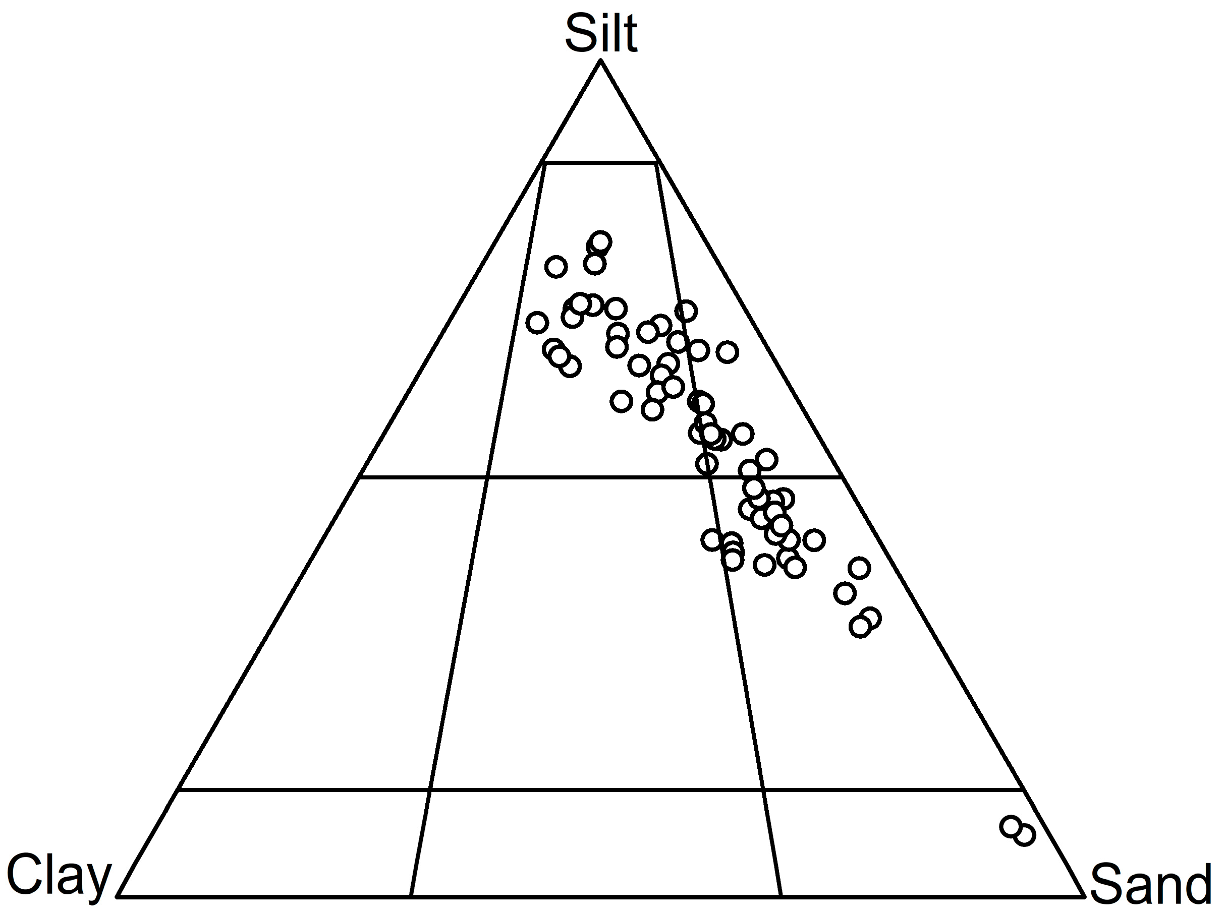
4.1. Sediment Type

The surface sediments in the study area are primarily composed of three types: sand, silt, and clay, which constitute 34.06%, 54.22%, and 11.72% of the total sediment composition, respectively. Notably, silt predominates in the sediment composition of the study area (Figure 2).

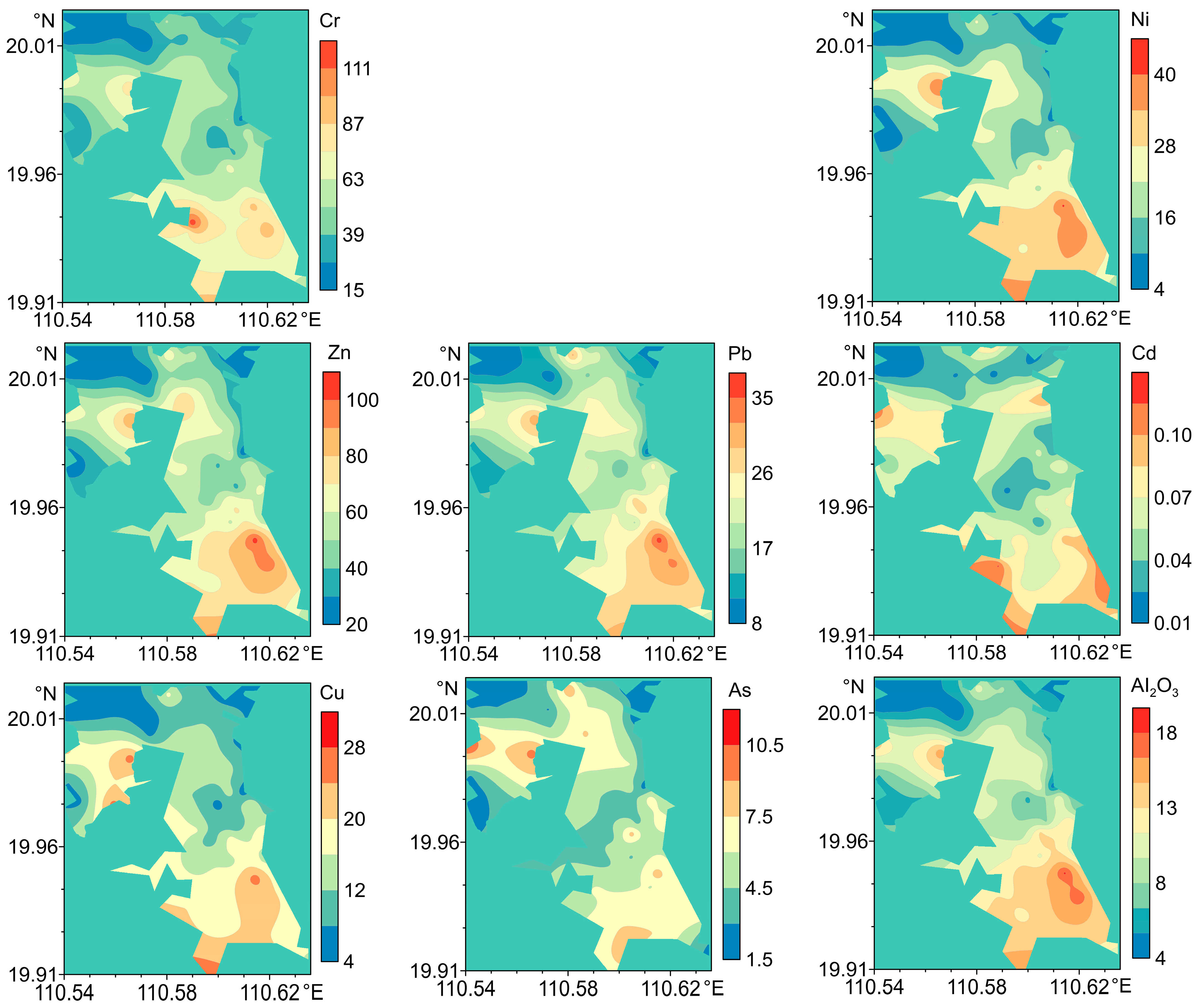
4.2. Content and Distributions of PTEs

The content of PTEs in the surface sediments of Dongzhai Harbor varies as follows (Table 1): Cu ranges from 4.85 to 36.33 mg/kg (mean: 14.07 mg/kg), Pb ranges from 8.84 to 36.61 mg/kg (mean: 20.63 mg/kg), Zn ranges from 20.3 to 113.9 mg/kg (mean: 55.01 mg/kg), Cr ranges from 18 to 119.9 mg/kg (mean: 53.24 mg/kg), Cd ranges from 0.018 to 0.155 mg/kg (mean: 0.066 mg/kg), Ni ranges from 4.96 to 52.06 mg/kg (mean: 20.03 mg/kg), and As ranges from 1.97 to 11.56 mg/kg (mean: 5.18 mg/kg). The average content of PTEs in the sediments, in descending order, are Zn > Cr > Pb > Ni > Cu > As > Cd. Only the contents of Cr (approximately 10.93% exceedance) and Cu (approximately 1.56% exceedance) exceeded MSQ I standards; all other elements remained within the limits established by the Marine Sediment Quality Standards [29].
When comparing the content of PTEs in the study area to the background values of deep soil sediments in Hainan, the average content of Cu, Pb, Cr, and Ni are significantly lower than those reported by He et al. [26]. The content of Zn and As are close to the background levels; however, the levels of Cd exhibit an increasing trend. The contents of PTEs in the sediments of the study area are comparable to those found in the Qizhou Islands and the eastern continental shelf of Hainan [11,12]. The average contents of all elements are considerably lower than those in the Gulf of Tonkin [14] but slightly higher than those in the Nandu River region [13]. Anzali coastal wetland and Khnifiss Lagoon National Park (Morocco) sediments contained much higher levels of Cd and As than the elements in the study area [30,31]. Overall, the pollution characteristics of elements in different regions exhibit significant variations, primarily influenced by local predominant economic activities (such as industry, agriculture, and urbanization) and natural conditions (such as geological background and hydrological features). The average contents of most heavy metal elements in the study area are lower than those in other regions of Hainan Province, indicating minimal influence from anthropogenic activities.
Table 1. Summary of PTEs in the surface sediments of the Dongzhai Harbor and other representative areas (unit: mg/kg).
LocationsCuPbZnCrCdNiAsReferences
Dongzhai Harbor14.0720.6355.0153.240.06620.035.18This study
4.85–36.338.84–36.6120.3–113.918–119.90.018–0.1554.96–52.061.97–11.56
The eastern continental shelf of Hainan Island29.419.281.457.30.1925.67.6[11]
Nandu River9.3216,630.129.10.0814.53.73[13]
Qizhou Island11.3121.0255.3847.450.09121.55NA[12]
Beibu Bay58.2627.9967.2853.650.16NA9.53[14]
Khnifiss Lagoon National
Park (Morocco)
12.512.141.052.20.3525.912.6[31]
Anzali coastal wetland47.0220.93112.64104.850.7852.3718.28[30]
Deep soil sediments in Hainan2029.258.965.20.0629.95.5[26]
ERM2702184103709.651.60.71[28]
ERL3446.7150811.220.90.15[28]
MSQ I≤35≤60≤150≤80≤0.5≤60≤20[29]
MSQ II≤100≤130≤350≤150≤1.5NA≤65
MSQ I = Marine Sediment Quality I; MSQ II = Marine Sediment Quality II; NA = not available.
The spatial distribution of PTEs in surface sediments is essential for assessing pollution levels and identifying potential sources. As illustrated in Figure 3, the distribution of various heavy metal elements within the study area demonstrates a consistent pattern. The northern channel of the study area connects to the open sea, facilitating the exchange of water between open water bodies, which results in a certain degree of dilution and dispersion of PTEs. In contrast, areas with high content are predominantly found in the northwest and southeast regions of the study area. This distribution is associated with the limited water exchange capabilities and hydrodynamic conditions within the bay. These regions serve as major shipping routes and sites of frequent aquaculture activities, contributing to the accumulation of PTEs.

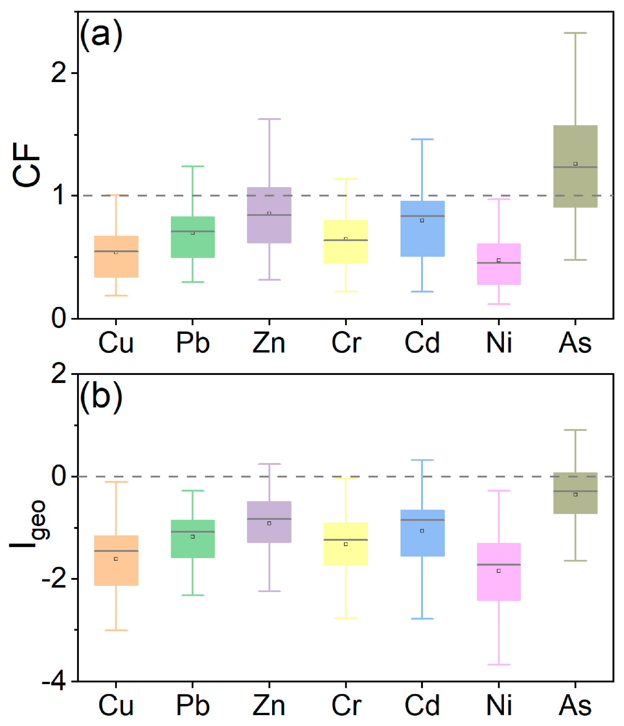
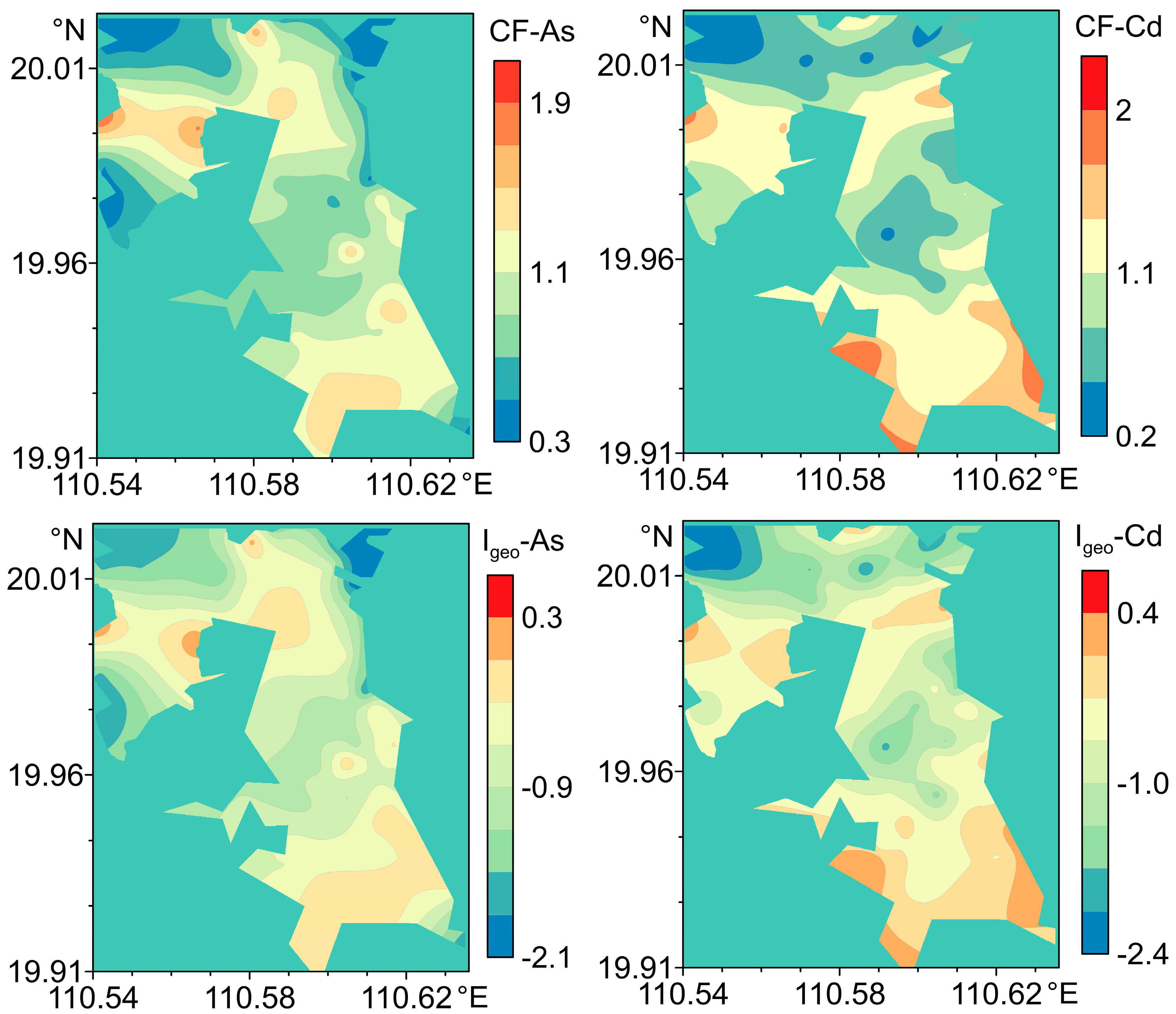
4.3. Contamination Factor

The average CF values in the study area are ranked as follows: As > Zn > Cd > Pb > Cr > Cu > Ni (Figure 4a). The CF averages for Cu (0.54), Pb (0.70), Zn (0.86), Cr (0.65), Cd (0.80), and Ni (0.48) are all less than 1, indicating that sediments are not contaminated by these heavy metal elements. In contrast, As (1.26) has an average value exceeding 1, suggesting that the study area is experiencing mild to moderate pollution from As, significantly influenced by anthropogenic inputs. The PLI values in the study area range from 0.31 to 1.61, with 26.56% of sampling sites exhibiting a PLI ≥ 1, which exceeds baseline levels of pollutants. This indicates that the overall pollution level in the study area is relatively low (Figure 5).

4.4. Geoaccumulation Index

The Igeo values were ranked as follows: As > Zn > Cd > Pb > Cr > Cu > Ni (Figure 4b). This ranking is largely consistent with the observations made for the CF values. The average Igeo values for Cu (−1.62), Pb (−1.17), Zn (−0.91), Cr (−1.32), Cd (−1.06), Ni (−1.85), and As (−0.35) were all below zero. The Igeo values exhibited significant variation among the different elements, with the maximum Igeo values for Cd and As being 0.73 and 0.49, respectively. These values indicate light contamination of Cd and As in localized areas (Figure 5). Overall, the elements mentioned are primarily attributed to natural sources, with minimal evidence of anthropogenic pollution. The distribution pattern of Igeo values for heavy metal elements closely resembles that of the CF values (Figure 5).

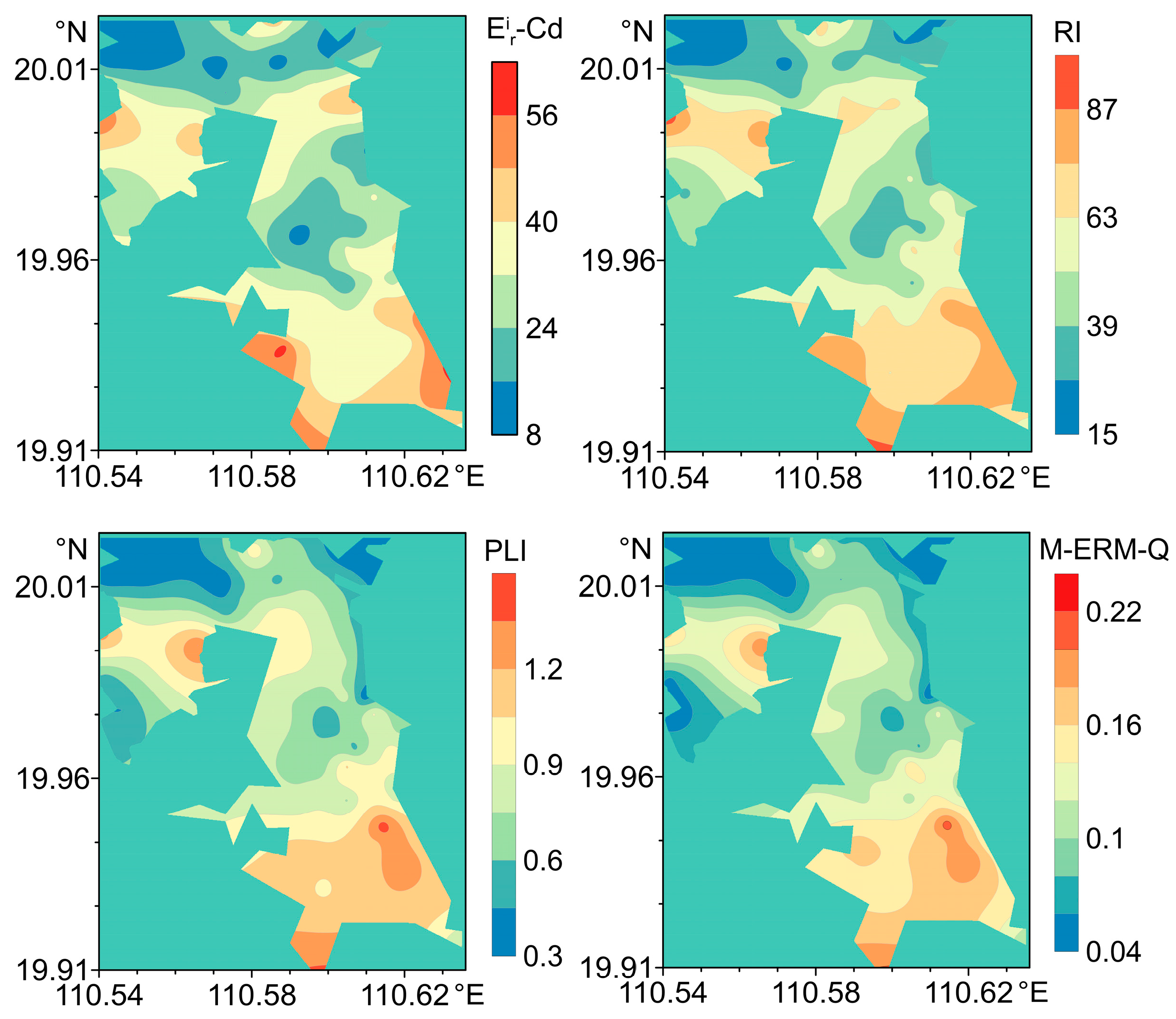
4.5. Ecological Risk Assessment

The results of the ecological risk assessment for heavy metal elements in the study area are presented in Table 2. The content of the PTEs, ranked from highest to lowest, are as follows: Cd > As > Pb > Cu > Ni > Cr > Zn. The average contents of the PTEs are below 40, indicating a relatively low ecological risk. The RI values range from 19.01 to 112.46, with an average of 54.15. Approximately 21.88% of the sampling sites exhibit a moderate ecological risk for Cd. Based on the RI results, the overall ecological risk level in the study area is low (Figure 6). The potential ecological risk values and the potential ecological risk index indicate that the increase in RI is primarily attributed to contributions from specific PTEs, likely resulting from particular human activities and natural conditions.

4.6. Health Risk Assessment

A quantitative assessment of health risk levels associated with PTEs in sediments was conducted to elucidate their potential toxic effects on the environment and biota. The hazard quotient values and their mean content for each element were as follows: Cu (0.14–1.07, mean 0.41), Pb (0.19–0.78, mean 0.44), Zn (0.14–0.76, mean 0.37), Cr (0.22–1.48, mean 0.66), Cd (0.02–0.14, mean 0.06), Ni (0.24–2.49, mean 0.96), and As (0.03–0.44, mean 0.22). Based on the mean HQ values, the risk levels of the seven elements in descending order were as follows: Ni > Cr > As > Pb > Cu > Zn > Cd. The HQ values for most elements ranged between 0.1 and 1, with only Cr, Ni, Cu, and As exceeding 1 at specific sampling stations. Furthermore, the mean effect range-median quotient results indicated that 46.88% of the sampling sites exhibited M-ERM-Q values below 0.1, while 53.12% of the sites showed values between 0.11 and 0.5 (Figure 6). The mean M-ERM-Q value was 0.11, corresponding to a 21% probability of toxicity risk, suggesting that the overall heavy metal toxicity risk in the study area remains within acceptable limits. The spatial distribution analysis revealed that higher M-ERM-Q values were predominantly concentrated in the southeastern region of the study area, consistent with the spatial patterns of the risk index and pollution load index. This spatial correspondence indicates that the potential ecological and toxicological risks in the study area are closely associated with the spatial distribution and contamination levels of Cd. Although some PTEs exhibited relatively high HQ values at specific sampling stations, the overall potential ecological and toxicological risks of most elements in the study area remain at relatively low levels, suggesting minimal significant toxic effects on biota.

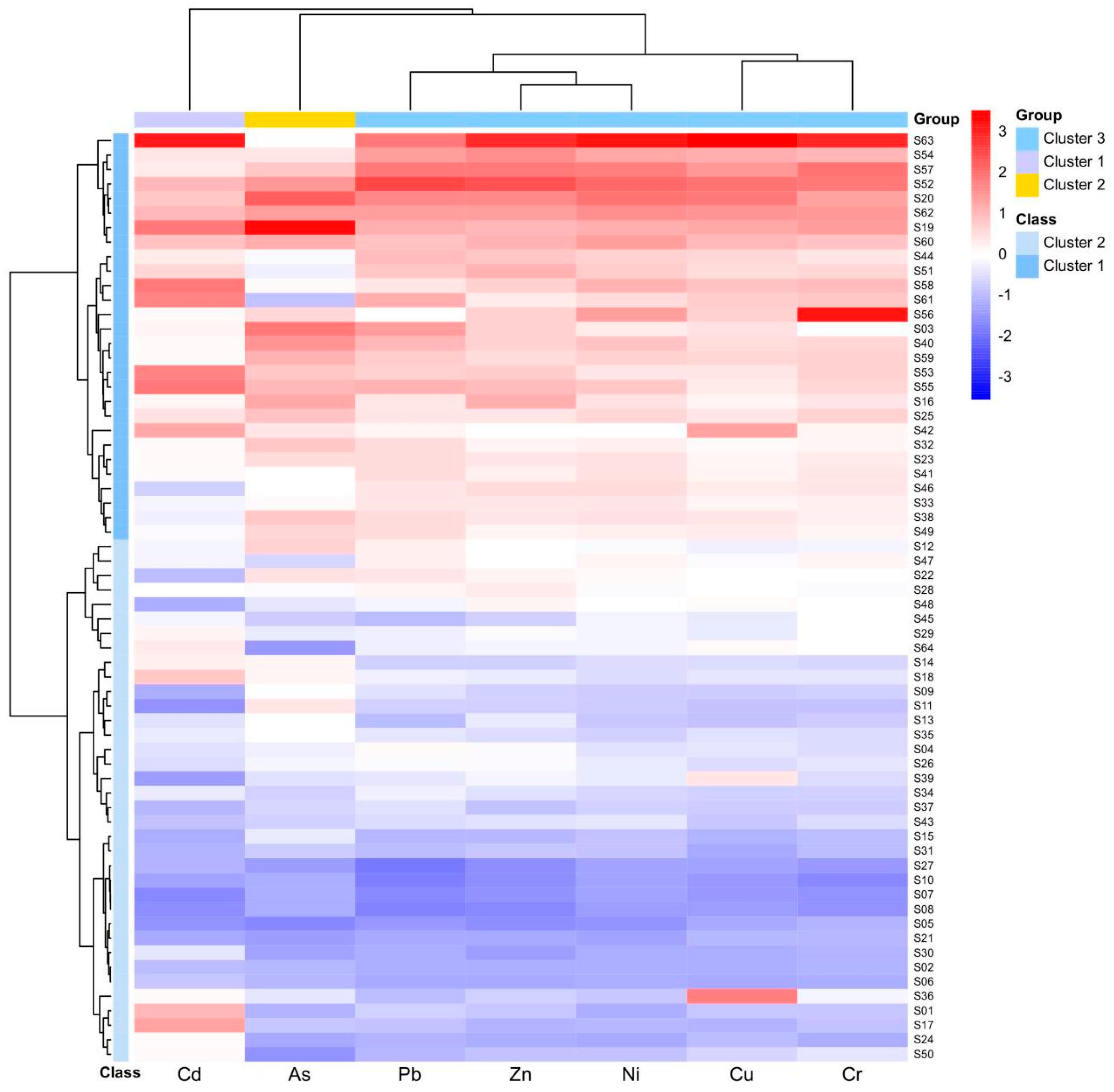
4.7. Sources of PTEs

4.7.1. Pearson Correlation Analysis

To investigate the sources and control mechanisms of PTEs in detail, a Pearson correlation analysis was conducted. The results of this analysis for Al2O3, heavy metal elements, and sediment components are presented in Table 3. Previous studies have indicated that fine sediments are significant carriers of PTEs [32,33,34,35]. The lack of a significant correlation between the elements and sediment components suggests that sediment type has a minimal impact on the enrichment of heavy metal elements in this region [19]. Except As and Cd, all other elements demonstrated significant correlations with Al2O3. Additionally, these elements exhibited significant correlations with one another, indicating that they may share similar sources [18,36]. According to the results from the CF and Igeo assessments, Cu, Pb, Cr, Ni, and Zn are primarily attributed to natural contributions. However, some sampling sites exhibited mild pollution from Cd, suggesting that these elements are influenced by both natural and anthropogenic activities. In contrast, the correlation between As and Al2O3 was relatively low, potentially affected by multiple sources. Previous research has indicated that the discharge of aquaculture wastewater often leads to increased content of As [18,37]. The southeastern region of the study area exhibited the highest content of PTEs, indicating that this area is subjected to pollution from local wastewater discharge and river inputs. Anthropogenic activities such as agriculture and aquaculture have exacerbated the accumulation of these heavy metal elements [12,27]. Rivers serve as conduits for urban sewage and aquaculture wastewater, continuously transporting these pollutants to the southeastern part of the study area [5,38].

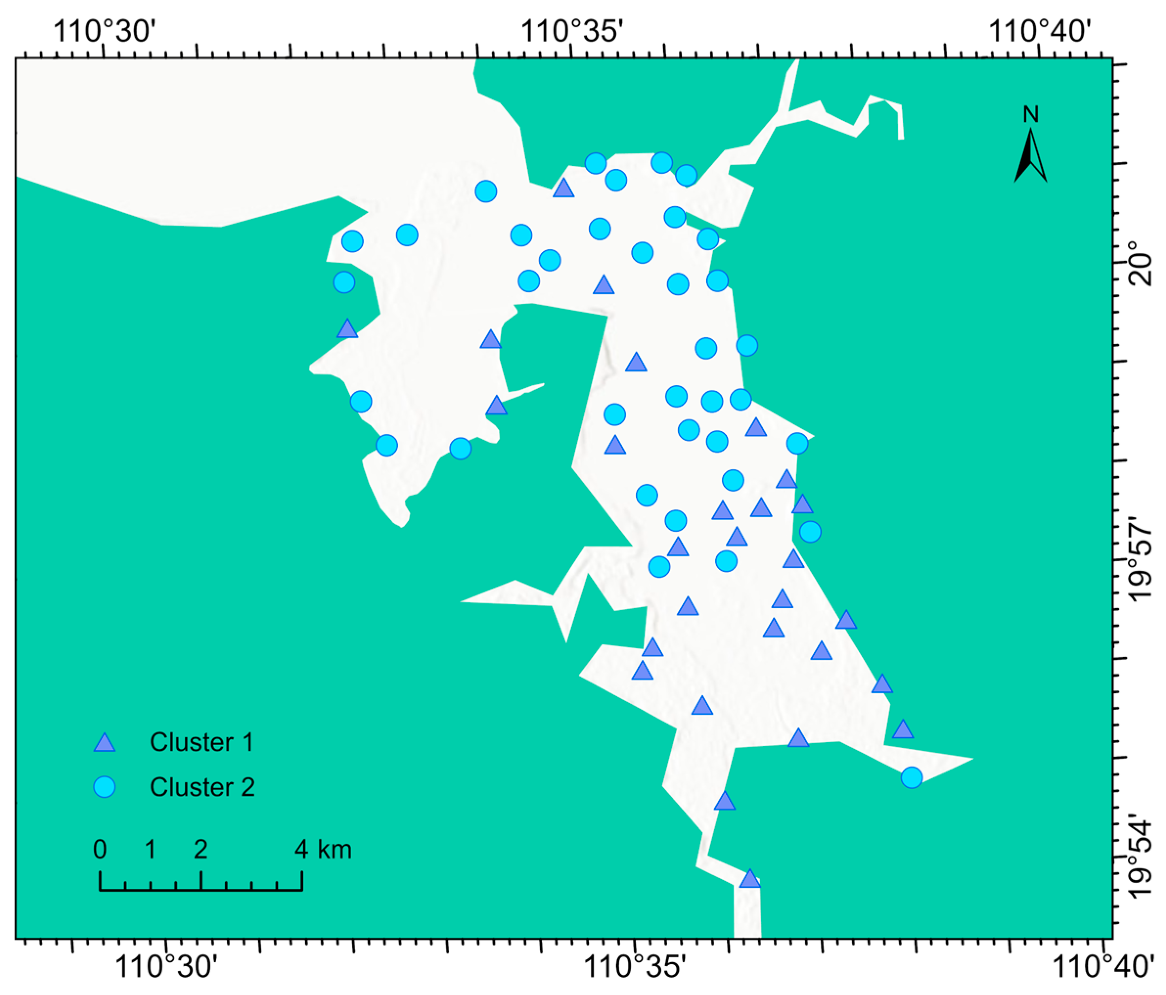
4.7.2. Hierarchical Cluster Analysis

Hierarchical cluster analysis (HCA) was employed to effectively discriminate the contamination characteristics of various elements and their inter-site correlations (Figure 7). The horizontal dendrogram classified the seven elements into three primary clusters, with their contamination characteristics and sources as follows: Cluster 1 was predominantly characterized by Cd, with previous studies identifying phosphate fertilizer application as a key factor contributing to Cd enrichment [12,39]. Therefore, Cluster 1 is primarily attributed to agricultural pollution in the study area [40]. Cluster 2 was mainly associated with As contamination. Spatial distribution analysis suggests that As enrichment is primarily influenced by fishing vessel activities in the navigation channels and aquaculture operations within the harbor [41]. Additionally, some studies have indicated that local As enrichment may result from geological factors, such as the release of arsenic from arsenic-rich minerals into the environment [40]. Thus, As in Cluster 2 is likely influenced by both aquaculture activities and geological factors. Cluster 3 primarily consisted of Pb, Zn, Ni, Cu, and Cr. Based on the evaluation results of the contamination factor and geo-accumulation index, the pollution in Cluster 3 is mainly attributed to parent material weathering in the region.
Vertical cluster analysis further divided the sampling sites in the study area into two regions with distinct contamination characteristics (Figure 8). Cluster 1 included 28 sites, with contamination hotspots primarily concentrated along the coast and in the southwestern part of the study area, showing a decreasing trend from the estuary to offshore areas [42,43]. This distribution pattern indicates that coastal human activities, such as agriculture and aquaculture, play a crucial role in heavy metal inputs. Cluster 2 comprised 36 sites with relatively lower pollution levels, showing no significant heavy metal enrichment. This suggests that the area is less affected by anthropogenic disturbances, with heavy metal content mainly controlled by natural background values. In conclusion, heavy metal enrichment in the study area is closely related to human activities, particularly aquaculture and agricultural practices, which significantly contribute to Cd and As pollution. Additionally, parent material weathering also influences the distribution of elements such as Pb, Zn, Ni, Cu, and Cr to some extent.

5. Conclusions

The results of this study offer comprehensive insights into the spatial distribution, pollution status, sources, and ecological risks associated with PTEs in the surface sediments of Dongzhai Harbor, Hainan. This research examined the pollution characteristics and sources of PTEs (Cr, Ni, Cu, Zn, As, Cd, Pb) in the surface sediments from the southeastern region of Hainan Island. The findings indicate that most elements generally comply with Marine Sediment Quality Standards, except Cr and Cu, which exceeded Class I standards at certain sampling sites. Cd and As typically exhibit elevated levels of pollution and accumulation, primarily concentrated in the southern part of the study area. This suggests that the pollutants are predominantly influenced by localized point sources, such as aquaculture and domestic wastewater. Overall, the study area is classified as having a low level of ecological risk, with Cd identified as the primary heavy metal pollutant and ecological risk factor. It is recommended that control and management measures for both point and non-point source pollution be enhanced to improve sediment quality in coastal areas. This study provides valuable references for pollution prevention and control in Dongzhai Harbor.

Author Contributions

G.Z. conceived and designed the experiments and analyzed the data; J.F. and J.W. implemented and processed the analysis results; G.Z., J.F., G.X., B.M., J.Z., M.R. and J.W. prepared the figures in the manuscript. W.L. supervised the findings of this work. All authors discussed the results and contributed to the final manuscript. All authors have read and agreed to the published version of the manuscript.

Funding

This research was jointly supported by the Hainan Province’s Key Research and Development Projects (ZDYF2024SHFZ071), Hainan Provincial Natural Science Foundation of China (421MS0813, 423RC556), and Innovative Research Projects for Postgraduates in Hainan Province (Qhys2024-189).

Data Availability Statement

Data are available on request from the authors.

Conflicts of Interest

The authors declare no conflict of interest.

References

  1. Fan, Y.; Chen, X.; Chen, Z.; Zhou, X.; Lu, X.; Liu, J. Pollution characteristics and source analysis of heavy metals in surface sediments of Luoyuan Bay, Fujian. Environ. Res. 2022, 203, 111911. [Google Scholar] [CrossRef] [PubMed]
  2. Xu, F.; Tian, X.; Yin, F.; Zhao, Y.; Yin, X. Heavy metals in the surface sediments of the northern portion of the South China Sea shelf: Distribution, contamination, and sources. Environ. Sci. Pollut. Res. 2016, 23, 8940–8950. [Google Scholar] [CrossRef]
  3. Pan, K.; Wang, W.-X. Trace metal contamination in estuarine and coastal environments in China. Sci. Total. Environ. 2012, 421-422, 3–16. [Google Scholar] [CrossRef] [PubMed]
  4. Qiu, Y.-W.; Yu, K.-F.; Zhang, G.; Wang, W.-X. Accumulation and partitioning of seven trace metals in mangroves and sediment cores from three estuarine wetlands of Hainan Island, China. J. Hazard. Mater. 2011, 190, 631–638. [Google Scholar] [CrossRef]
  5. Yi, S.; Song, Z.; Lin, J.; Liu, W.; Li, B. Distribution, sources and influencing factors of heavy metals in the Ledong Sea, South China Sea. Mar. Pollut. Bull. 2024, 202, 116396. [Google Scholar] [CrossRef]
  6. Wang, M.; Chen, Q.; Cui, J.; Yu, Z.; Wang, W.; Sun, Z.; Chen, Q. Distribution, ecological risk, and sediment-influencing mechanisms of heavy metals in surface sediments along the intertidal gradient in typical mangroves in Hainan, China. Mar. Pollut. Bull. 2024, 206, 116677. [Google Scholar] [CrossRef]
  7. Xu, F.; Hu, B.; Zhao, J.; Liu, X.; Xu, K.; Xiong, Z.; Wang, F.; Ding, X.; Li, Q.; Guo, J. Provenance and weathering of sediments in the deep basin of the northern South China Sea during the last 38 kyr. Mar. Geol. 2021, 440, 106602. [Google Scholar] [CrossRef]
  8. Xu, F.; Zhang, X.; Xu, J.; Sun, Z.; Yuan, S.; Liu, X. Sea level and low-latitude climate control on sedimentary provenance and paleoenvironmental evolution in the central Okinawa Trough since 19 cal. ka BP. Palaeogeogr. Palaeoclim. Palaeoecol. 2025, 658, 112621. [Google Scholar] [CrossRef]
  9. Li, P.; Li, X.; Bai, J.; Meng, Y.; Diao, X.; Pan, K.; Zhu, X.; Lin, G. Effects of land use on the heavy metal pollution in mangrove sediments: Study on a whole island scale in Hainan, China. Sci. Total. Environ. 2022, 824, 153856. [Google Scholar] [CrossRef]
  10. Zhang, J.; Wang, D.R.; Jennerjahn, T.; Dsikowitzky, L. Land–sea interactions at the east coast of Hainan Island, South China Sea: A synthesis. Cont. Shelf Res. 2013, 57, 132–142. [Google Scholar] [CrossRef]
  11. Xu, F.; Tian, X.; Yin, X.; Yan, H.; Yin, F.; Liu, Z. Trace metals in the surface sediments of the eastern continental shelf of Hainan Island: Sources and contamination. Mar. Pollut. Bull. 2015, 99, 276–283. [Google Scholar] [CrossRef] [PubMed]
  12. Fan, J.; Zhang, L.; Wang, A.; Meng, X.; Xu, C.; Wang, X.; Wang, S.; Huang, W.; Xu, F. Distribution, sources, and contamination evaluation of heavy metals in surface sediments of the Qizhou Island sea area in Hainan, China. Mar. Pollut. Bull. 2024, 208, 116933. [Google Scholar] [CrossRef]
  13. Sun, Y.; Yang, J.; Gong, J.; Duan, Z. Contamination and source of metals in surface sediments from the Nandu River of Hainan Island, China. Mar. Pollut. Bull. 2022, 182, 114037. [Google Scholar] [CrossRef] [PubMed]
  14. Dou, Y.; Li, J.; Zhao, J.; Hu, B.; Yang, S. Distribution, enrichment and source of heavy metals in surface sediments of the eastern Beibu Bay, South China Sea. Mar. Pollut. Bull. 2013, 67, 137–145. [Google Scholar] [CrossRef]
  15. Zhang, L.; Ni, Z.; Cui, L.; Li, J.; He, J.; Jiang, Z.; Huang, X. Heavy metal accumulation and ecological risk on four seagrass species in South China. Mar. Pollut. Bull. 2021, 173, 113153. [Google Scholar] [CrossRef] [PubMed]
  16. Hao, Z.; Qian, J.; Zheng, F.; Lin, B.; Xu, M.; Feng, W.; Zou, X. Human-influenced changes in pollution status and potential risk of sediment heavy metals in Xincun Bay, a typical lagoon of Hainan, China. Mar. Pollut. Bull. 2024, 199, 115949. [Google Scholar] [CrossRef]
  17. Liu, B.; Xia, P.; Du, J.; Luo, X.; Zhai, R.; Lin, J. Sedimentary records of environmental evolution in Dongzhai Port mangrove swamps (South China) over the last hundred years: Insights from corrections of grain-size effects. Environ. Pollut. 2024, 343, 123179. [Google Scholar] [CrossRef]
  18. Guo, Y.; Ke, X.; Zhang, J.; He, X.; Li, Q.; Zhang, Y. Distribution, Risk Assessment and Source of Heavy Metals in Mangrove Wetland Sediments of Dongzhai Harbor, South China. Int. J. Environ. Res. Public Health 2023, 20, 1090. [Google Scholar] [CrossRef]
  19. Zhang, G.; Chen, S.; Long, R.; Ma, B.; Chang, Y.; Mao, C. Distribution of Heavy Metals in Surface Sediments of a Tropical Mangrove Wetlands in Hainan, China, and Their Biological Effectiveness. Minerals 2023, 13, 1476. [Google Scholar] [CrossRef]
  20. Håkanson, L. An ecological risk index for aquatic pollution control. A sedimentological approach. Water Res. 1980, 14, 975–1001. [Google Scholar] [CrossRef]
  21. Tomlinson, D.L.; Wilson, J.G.; Harris, C.R.; Jeffrey, D.W. Problems in the assessment of heavy-metal levels in estuaries and the formation of a pollution index. Helgoländer Meeresunters. 1980, 33, 566–575. [Google Scholar] [CrossRef]
  22. Al-Hashim, M.H.; El-Sorogy, A.S.; Al Qaisi, S.; Alharbi, T. Contamination and ecological risk of heavy metals in Al-Uqair coastal sediments, Saudi Arabia. Mar. Pollut. Bull. 2021, 171, 112748. [Google Scholar] [CrossRef] [PubMed]
  23. Zhuang, Q.; Li, G.; Liu, Z. Distribution, source and pollution level of heavy metals in river sediments from South China. CATENA 2018, 170, 386–396. [Google Scholar] [CrossRef]
  24. Wang, F.; Guan, Q.; Tian, J.; Lin, J.; Yang, Y.; Yang, L.; Pan, N. Contamination characteristics, source apportionment, and health risk assessment of heavy metals in agricultural soil in the Hexi Corridor. CATENA 2020, 191, 104573. [Google Scholar] [CrossRef]
  25. Hu, B.; Cui, R.; Li, J.; Wei, H.; Zhao, J.; Bai, F.; Song, W.; Ding, X. Occurrence and distribution of heavy metals in surface sediments of the Changhua River Estuary and adjacent shelf (Hainan Island). Mar. Pollut. Bull. 2013, 76, 400–405. [Google Scholar] [CrossRef]
  26. He, Y.S.; Zhang, G.C.; Xue, G.C.; Guo, Y.P. Handbook of Soil Geochemistry on Hainan Island; China University of Geosciences Press: Wuhan, China, 2021. [Google Scholar]
  27. Cai, P.; Cai, G.; Yang, J.; Li, X.; Lin, J.; Li, S.; Zhao, L. Distribution, risk assessment, and quantitative source apportionment of heavy metals in surface sediments from the shelf of the northern South China Sea. Mar. Pollut. Bull. 2023, 187, 114589. [Google Scholar] [CrossRef]
  28. Long, E.R.; Macdonald, D.D.; Smith, S.L.; Calder, F.D. Incidence of adverse biological effects within ranges of chemical concentrations in marine and estuarine sediments. Environ. Manag. 1995, 19, 81–97. [Google Scholar] [CrossRef]
  29. GB 18668-2002; The PeoplE’s Republic of China National Standards—Marine Sediment Quality. CSBTS: Beijing, China, 2002.
  30. Zarei, S.; Karbassi, A.; Sadrinasab, M.; Sarang, A. Investigating heavy metal pollution in Anzali coastal wetland sediments: A statistical approach to source identification. Mar. Pollut. Bull. 2023, 194, 115376. [Google Scholar] [CrossRef]
  31. Tnoumi, A.; Angelone, M.; Armiento, G.; Caprioli, R.; Crovato, C.; De Cassan, M.; Montereali, M.R.; Nardi, E.; Parrella, L.; Proposito, M.; et al. Heavy metal content and potential ecological risk assessment of sediments from Khnifiss Lagoon National Park (Morocco). Environ. Monit. Assess. 2022, 194, 356. [Google Scholar] [CrossRef]
  32. Duodu, G.O.; Goonetilleke, A.; Ayoko, G.A. Comparison of pollution indices for the assessment of heavy metal in Brisbane River sediment. Environ. Pollut. 2016, 219, 1077–1091. [Google Scholar] [CrossRef]
  33. Ip, C.C.; Li, X.-D.; Zhang, G.; Wai, O.W.; Li, Y.-S. Trace metal distribution in sediments of the Pearl River Estuary and the surrounding coastal area, South China. Environ. Pollut. 2007, 147, 311–323. [Google Scholar] [CrossRef] [PubMed]
  34. Zhang, L.; Ye, X.; Feng, H.; Jing, Y.; Ouyang, T.; Yu, X.; Liang, R.; Gao, C.; Chen, W. Heavy metal contamination in western Xiamen Bay sediments and its vicinity, China. Mar. Pollut. Bull. 2007, 54, 974–982. [Google Scholar] [CrossRef] [PubMed]
  35. Lin, S.; Hsieh, I.-J.; Huang, K.-M.; Wang, C.-H. Influence of the Yangtze River and grain size on the spatial variations of heavy metals and organic carbon in the East China Sea continental shelf sediments. Chem. Geol. 2002, 182, 377–394. [Google Scholar] [CrossRef]
  36. Liang, J.; Liu, J.; Xu, G.; Chen, B. Distribution and transport of heavy metals in surface sediments of the Zhejiang nearshore area, East China Sea: Sedimentary environmental effects. Mar. Pollut. Bull. 2019, 146, 542–551. [Google Scholar] [CrossRef]
  37. Xiao, H.; Shahab, A.; Ye, F.; Wei, G.; Li, J.; Deng, L. Source-specific ecological risk assessment and quantitative source apportionment of heavy metals in surface sediments of Pearl River Estuary, China. Mar. Pollut. Bull. 2022, 179, 113726. [Google Scholar] [CrossRef]
  38. Jaskuła, J.; Sojka, M. Assessment of spatial distribution of sediment contamination with heavy metals in the two biggest rivers in Poland. CATENA 2022, 211, 105959. [Google Scholar] [CrossRef]
  39. Xu, F.; Hu, B.; Dou, Y.; Liu, X.; Wan, S.; Xu, Z.; Tian, X.; Liu, Z.; Yin, X.; Li, A. Sediment provenance and paleoenvironmental changes in the northwestern shelf mud area of the South China Sea since the mid-Holocene. Cont. Shelf Res. 2017, 144, 21–30. [Google Scholar] [CrossRef]
  40. Shetty, B.R.; Pai, B.J.; Salmataj, S.A.; Naik, N. Assessment of Carcinogenic and non-carcinogenic risk indices of heavy metal exposure in different age groups using Monte Carlo Simulation Approach. Sci. Rep. 2024, 14, 30319. [Google Scholar] [CrossRef]
  41. Jian, L.; Zhang, Y.; Luo, Y.; Liu, S.; Zheng, X. Distribution and human health risk assessment of trace elements in the bivalve Polymesoda erosa from mangroves on Hainan Island, China. J. Food Compos. Anal. 2024, 132, 106302. [Google Scholar] [CrossRef]
  42. Liu, Y.; Ji, C.; Fu, B.; He, L.; Fu, Q.; Shen, M.; Zhao, Z. Factors influencing the accumulation of Pd in mangrove wetland sediments in Dongzhai Harbor, Hainan, China. J. Coast. Conserv. 2019, 23, 1039–1045. [Google Scholar] [CrossRef]
  43. Zhang, G.; Xue, G.; Ruan, M.; He, Y.; Lin, D.; Du, S. Phosphorus Species, Influencing and Release Risks Assessment in Mangrove Wetland Sediments of Dongzhai Harbor on Hainan Island, China. Sustainability 2022, 14, 14344. [Google Scholar] [CrossRef]
Figure 1. (ac) The geographical location of the study area.
Minerals 15 00349 g001
Figure 2. Ternary diagram of sediment particle-size characteristics of the Dongzhai Harbor.
Minerals 15 00349 g002
Figure 3. Spatial distributions of the contents for PTEs (unit: mg/kg) and Al2O3 (unit: %) in the surface sediments of the Dongzhai Harbor.
Minerals 15 00349 g003
Figure 4. (a) CF and (b) Igeo of PTEs in the surface sediments of the Dongzhai Harbor.
Minerals 15 00349 g004
Figure 5. Spatial distributions of the CF and Igeo values for As and Cd in the surface sediments of the Dongzhai Harbor.
Minerals 15 00349 g005
Figure 6. The spatial distribution of E r i values for Cd, PLI, RI, and M-ERM-Q on the surface sediments of the Dongzhai Harbor.
Minerals 15 00349 g006
Figure 7. Hierarchical cluster analysis of PTEs in the surface sediments of the Dongzhai Harbor.
Minerals 15 00349 g007
Figure 8. Spatial distribution of clusters extracted from the hierarchical cluster analysis of PTEs in the surface sediments of the Dongzhai Harbor.
Minerals 15 00349 g008
Table 2. E r i and RI of PTEs in surface sediments of the Dongzhai Harbor.
Parameters E r i RI
CuPbZnCrCdNiAs
Max9.086.271.933.6874.408.7121.01112.46
Min1.211.510.340.558.660.833.5819.01
Mean3.523.530.931.6331.763.359.4254.15
Table 3. Pearson correlation coefficients of PTEs, Al2O3, and sediment components in the surface sediments of the Dongzhai Harbor.
VariablesAl2O3CuPbZnCrCdNiAsSandSilt
Cu0.880 **
Pb0.963 **0.844 **
Zn0.963 **0.894 **0.955 **
Cr0.913 **0.882 **0.847 **0.908 **
Cd0.675 **0.706 **0.659 **0.671 **0.684 **
Ni0.964 **0.901 **0.923 **0.969 **0.951 **0.670 **
As0.692 **0.629 **0.760 **0.732 **0.643 **0.463 **0.711 **
Sand0.0650.0050.0780.0840.061−0.0350.1030.163
Silt−0.0220.043−0.048−0.052−0.0150.07−0.053−0.137−0.974 **
Clay−0.177−0.159−0.145−0.151−0.186−0.092−0.221−0.181−0.683 **0.499 **
** Correlation is significant at the 0.01 level (two-tailed). * Correlation is significant at the 0.05 level (two-tailed).
Disclaimer/Publisher’s Note: The statements, opinions and data contained in all publications are solely those of the individual author(s) and contributor(s) and not of MDPI and/or the editor(s). MDPI and/or the editor(s) disclaim responsibility for any injury to people or property resulting from any ideas, methods, instructions or products referred to in the content.

