Investigation of Development Applications: A GIS Based Spatiotemporal Analysis in the City of Sydney Area 2004–2022
Abstract
1. Introduction
1.1. Problem Statement
1.2. Research Aim and Objectives
- What is the spatiotemporal distribution of developments?
- Is there a spatiotemporal pattern of development spending?
- Is there a pattern of evolution in different categories of proposed development use?
- How do assessment times vary between DAs?
- DA hot and cold spots
- DA assessment time patterns
- DA estimated cost
- DA proposed usage patterns
2. Literature Review
2.1. The Need for Better Informed Development
2.2. Current Development Assessment Authorities in Sydney
2.3. Current Development Types in Sydney
2.3.1. Exempt Developments and Complying Developments
2.3.2. Major Projects
2.3.3. Development Applications
2.4. COVID-19 and Development
2.5. Development Investigation with GIS
3. Methodology
3.1. Study Extent
3.2. Study Period
3.3. Data Sources
3.3.1. Background Data
3.3.2. Development Data
3.3.3. Local Environmental Plan (LEP) Land Zoning Data
3.4. Data Preparation
3.4.1. Data Cleaning
3.4.2. New Fields
3.4.3. DA by Application Type
3.4.4. DA by Proposed Usage
3.4.5. Suburb and Property Boundaries
3.4.6. Unique Counting of DAs
3.5. Data Analysis
3.5.1. General Charts and Maps
3.5.2. Spatial Autocorrelation and Hot Spot Analysis
3.5.3. Space Time Cube
4. Results
4.1. DA Numbers and Locations
4.1.1. DA Numbers
4.1.2. DA Locations
4.2. DA Estimated Value
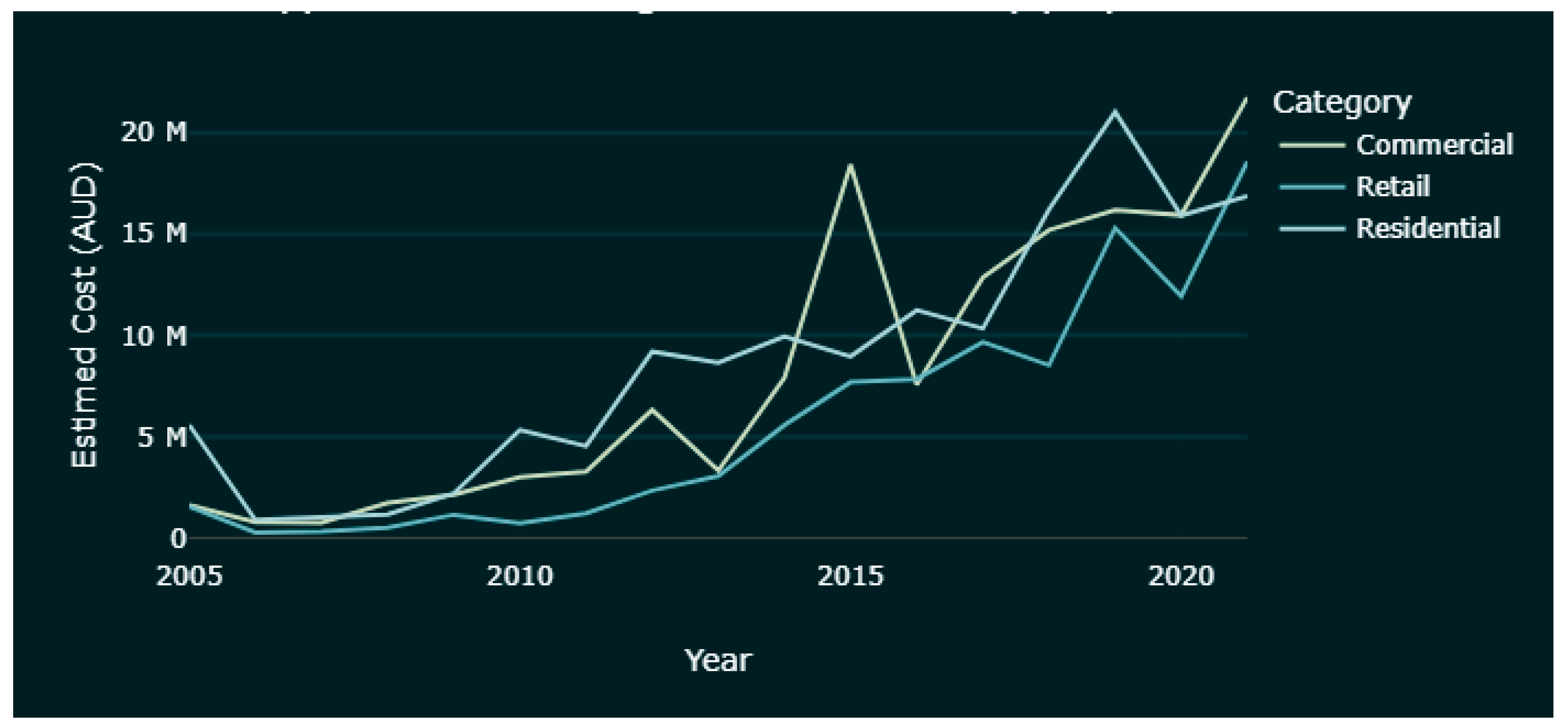
4.2.1. Overview
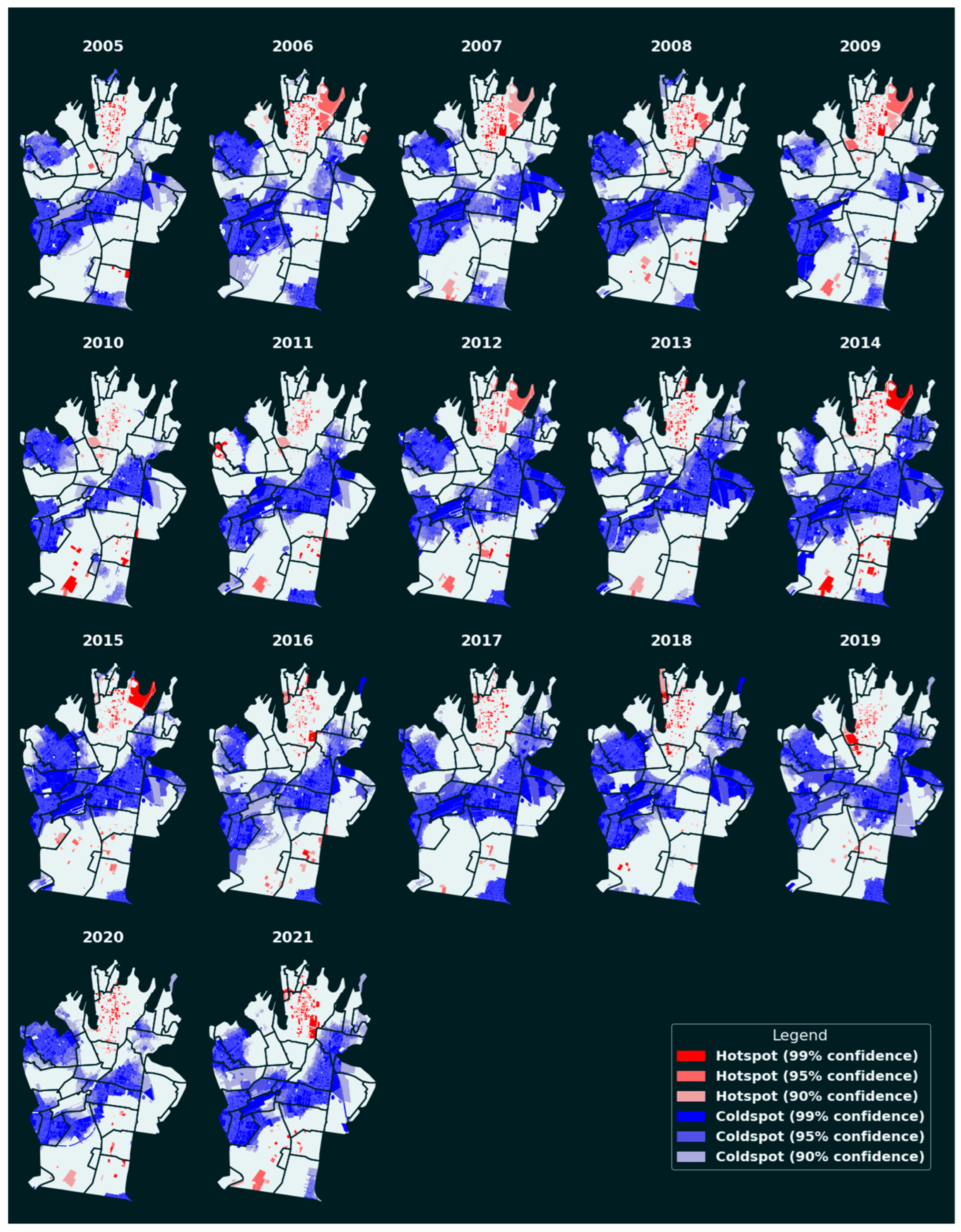
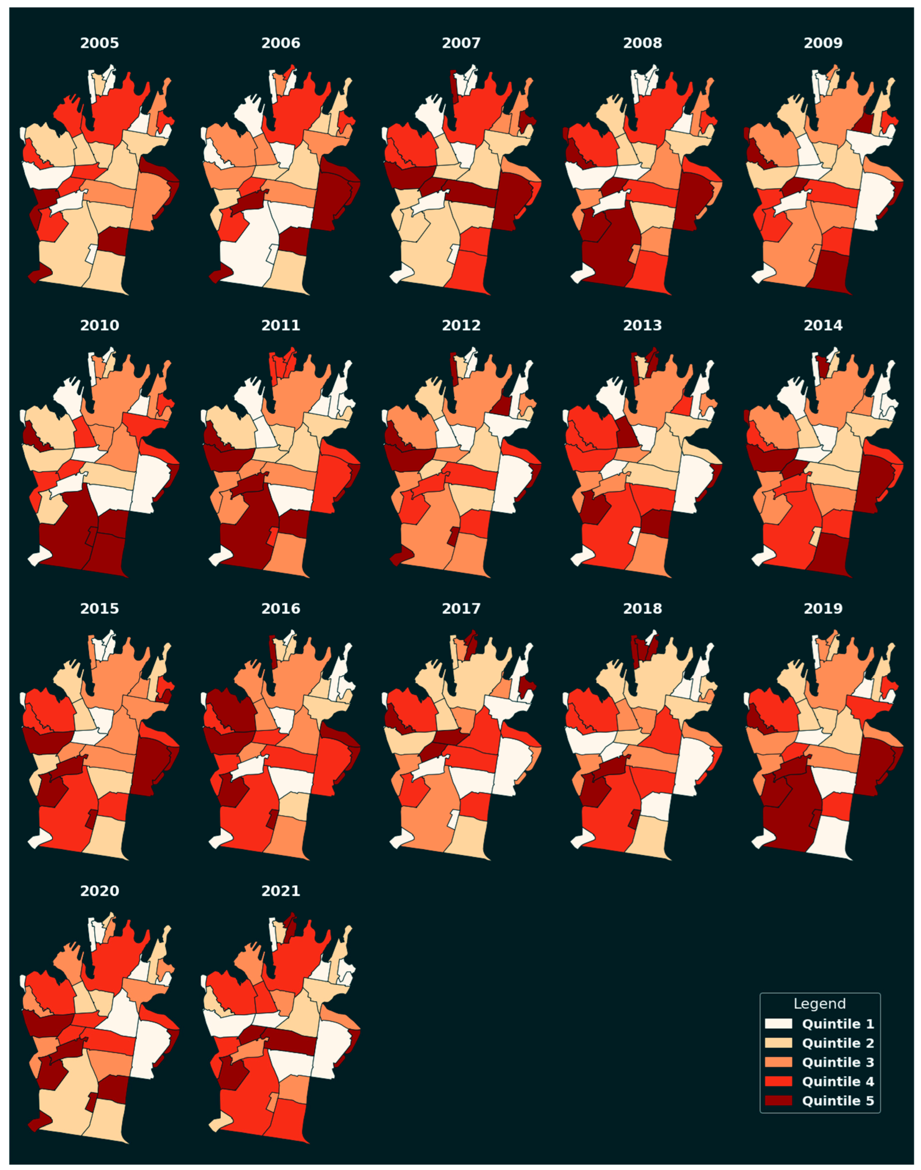
4.2.2. Investment Hot and Cold Spots
4.3. Approved DA Usage
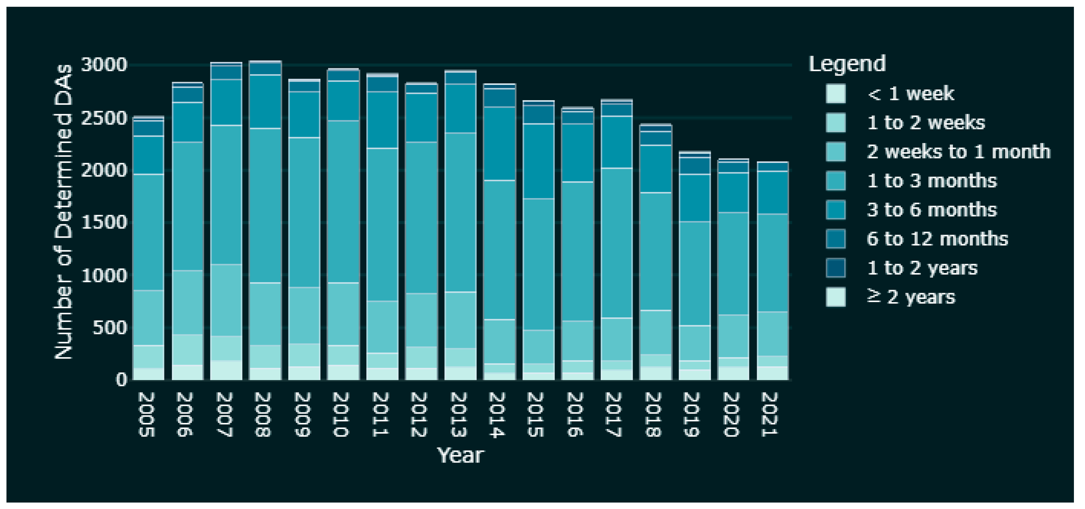
4.4. DA Assessment Time
4.5. DA Dashboard
5. Discussion
5.1. Development as a Sign of Socioeconomic Activity
5.2. DA Processing as a Constraint on Socioeconomic Progress
5.3. Evolving Uses as an Indicator of Changing Community Needs
5.4. Limitations
5.4.1. Improving Data Availability
5.4.2. Property Boundary Data Availability
5.4.3. Existing and Proposed Land Usage
6. Conclusions
6.1. Further Applications
6.1.1. Broader Time Scale Investigation
6.1.2. Building Height Compliance and Other Detailed Investigations
6.1.3. Other Development Data
6.1.4. Wider Geographical Area
6.2. Recommendations
Author Contributions
Funding
Data Availability Statement
Conflicts of Interest
References
- Searle, G.H. Population growth and development: An outcome of Sydney’s metropolitan governance. Aust. Plan. 2020, 56, 65–72. [Google Scholar] [CrossRef]
- Greater Sydney Commission. Past, Present and Future. Available online: https://www.greater.sydney/content/past-present-and-future (accessed on 11 June 2022).
- Australian Bureau of Statistics. Regional Population. Available online: https://www.abs.gov.au/statistics/people/population/regional-population/latest-release#capital-cities (accessed on 11 June 2022).
- Greater Cities Commission. A Metropolis of Three Cities. Available online: https://greatercities.au/metropolis-of-three-cities (accessed on 11 June 2022).
- City of Sydney. City of Sydney Notification of Planning and Development Applications Development Control Plan 2005. Available online: https://www.cityofsydney.nsw.gov.au/development-control-plans/notification-planning-development-applications-dcp-2005 (accessed on 16 August 2021).
- Smith, S. The NSW Planning System: Proposed Reforms. Available online: https://www.parliament.nsw.gov.au/researchpapers/Pages/the-nsw-planning-system-proposed-reforms.aspx (accessed on 17 August 2021).
- The World Bank. Defining the Planning Framework. Available online: https://urban-regeneration.worldbank.org/node/50 (accessed on 18 July 2021).
- NSW Government. New Portal Makes Planning System Easier. Available online: https://www.planningportal.nsw.gov.au/news/new-portal-makes-planning-system-easier (accessed on 14 August 2021).
- CSIRO. Launch of the NSW Spatial Digital Twin: Better Planning, Design and Management of Australian Citie. Available online: https://research.csiro.au/icv/nsw-digital-twin/ (accessed on 15 August 2021).
- Hawken, S.; Han, H.; Pettit, C. (Eds.) Open Cities|Open Data: Collaborative Cities in the Information Era; Palgrave Macmillan: London, UK; Springer: Singapore, 2020. [Google Scholar]
- Jacobs, J. The Death and Life of Great American Cities; Vintage Books: New York, NY, USA, 1992. [Google Scholar]
- Thompson, S.; Maginn, P.J. Planning Australia: An Overview of Urban and Regional Planning, 2nd ed.; Cambridge University Press: Cambridge, NY, USA, 2012. [Google Scholar]
- World Green Building Council. New Report: The Building and Construction Sector Can Reach Net Zero Carbon Emissions by 2050. Available online: https://www.worldgbc.org/news-media/WorldGBC-embodied-carbon-report-published (accessed on 17 August 2021).
- Bauer, K.L. Reforms to the NSW Planning System & Introduction of a New Assessment Process for State Significant Development: A Case Study. Available online: https://papers.ssrn.com/sol3/papers.cfm?abstract_id=1021485 (accessed on 17 August 2021).
- McFarland, P. The best planning system in Australia or a system in need of review? An analysis of the New South Wales planning system. Plan. Perspect. 2011, 26, 403–422. [Google Scholar] [CrossRef]
- City of Sydney. Committee Details. Available online: https://meetings.cityofsydney.nsw.gov.au/mgCommitteeDetails.aspx?ID=139 (accessed on 25 July 2021).
- NSW Government. Development Assessment Exempt Development. Available online: https://www.planningportal.nsw.gov.au/development-assessment/exempt-development (accessed on 1 April 2021).
- NSW Government. Planning Approval Pathways: Complying Development. Available online: https://pp.planningportal.nsw.gov.au/onlinecdc (accessed on 25 July 2021).
- NSW Government. State Significant Development. Available online: https://www.planning.nsw.gov.au/Assess-and-Regulate/Development-Assessment/Planning-Approval-Pathways/State-Significant-Development (accessed on 25 July 2021).
- NSW Government. Major Project Assessments. Available online: http://majorprojects.planning.nsw.gov.au/page/ (accessed on 25 July 2021).
- Ruming, K. Facilitating faster approval: Council reflections on the changing NSW planning and development assessment process. In Proceedings of the 4th State of Australian Cities Conference, Perth, Australia, 24–27 November 2009. [Google Scholar]
- NSW Government. Part 3A Development. Available online: https://www.planning.nsw.gov.au/Assess-and-Regulate/Development-Assessment/Planning-Approval-Pathways/Part-3a-Development (accessed on 25 July 2021).
- NSW Government. Major Projects. Available online: https://www.planningportal.nsw.gov.au/major-projects/ (accessed on 24 March 2021).
- NSW Government. Local Development. Available online: https://www.planning.nsw.gov.au/Assess-and-Regulate/Development-Assessment/Planning-Approval-Pathways/Local-Development (accessed on 25 July 2021).
- City of Sydney. Development Application Search Results. Available online: https://online2.cityofsydney.nsw.gov.au/DA/IndividualApplication?tpklapappl=1454583 (accessed on 24 July 2021).
- City of Sydney. On Exhibition—All Applications. Available online: https://online2.cityofsydney.nsw.gov.au/DA/OnExhibitions (accessed on 24 July 2021).
- City of Sydney. City Monitor Reports. Available online: https://www.cityofsydney.nsw.gov.au/surveys-case-studies-reports/city-monitor-reports (accessed on 24 July 2021).
- City of Sydney. Development Monitoring. Available online: https://cityofsydney.maps.arcgis.com/apps/webappviewer/index.html?id=ab67ecb8c37f4ae38ac77066e02b03fe (accessed on 24 July 2021).
- World Heath Organisation. WHO Director-General’s Opening Remarks at the Media Briefing on COVID-19—11 March 2020. Available online: https://www.who.int/dg/speeches/detail/who-director-general-s-opening-remarks-at-the-media-briefing-on-covid-19---11-march-2020 (accessed on 6 October 2020).
- Albani, M. There Is No Returning to Normal after COVID-19. But There is a Path Forward. Available online: https://www.weforum.org/agenda/2020/04/covid-19-three-horizons-framework/ (accessed on 6 October 2020).
- Greater Sydney Commision. City-Shaping Impacts of COVID-19: Towards a Resilient Greater Sydney. Available online: https://greatercities.au/thought-leadership/city-shaping-impacts-of-covid-19 (accessed on 11 June 2022).
- United Nations. Policy Brief: COVID-19 in an Urban World; United Nations: New York, NY, USA, 2020.
- Maginn, P.J.; Mortimer, G. How COVID All but Killed the Australian CBD; The University of Western Australia: Crawley, Australia, 2020. [Google Scholar]
- Australian Government Centre for Population. Insights from Australia’s First Population Statement. Available online: https://population.gov.au/publications/publications-population-statement.html (accessed on 18 August 2021).
- O’Sullivan, M. COVID-19 to Reshape Sydney in ‘Biggest Way’ since Spanish Flu as Population Stalls. Available online: https://www.smh.com.au/national/nsw/covid-19-to-reshape-sydney-in-biggest-way-since-spanish-flu-as-population-stalls-20201011-p56412.html (accessed on 18 August 2021).
- Thakur, P.; Rawnsley, T. COVID-19 Impacts Both Cities and Regional Population Growth. Available online: https://newsroom.kpmg.com.au/covid-19-impacts-cities-regional-population-growth/ (accessed on 18 August 2021).
- Sharifi, A.; Khavarian-Garmsir, A.R. The COVID-19 pandemic: Impacts on cities and major lessons for urban planning, design, and management. Sci. Total Environ. 2020, 749, 142391. [Google Scholar] [CrossRef] [PubMed]
- Malczewski, J.; Rinner, C. Multicriteria Decision Analysis in Geographic Information Science; Springer Science & Business Media: New York, NY, USA, 2015. [Google Scholar]
- Malczewski, J. GIS-based land-use suitability analysis: A critical overview. Prog. Plan. 2004, 62, 3–65. [Google Scholar] [CrossRef]
- Environment, N.D.o.P.a. Online Portal Speeds Up Planning in NSW. Available online: https://pp.planningportal.nsw.gov.au/news/online-portal-speeds-planning-nsw (accessed on 18 August 2021).
- Manandhar, R.; Odeh, I.; Ancev, T. Assessment of Spatial-Temporal Expansion of Built-up and Residential-Commercial Dwellings with Some Economic Implications: A Case Study in the Lower Hunter of Eastern Australia. Land 2014, 3, 239–259. [Google Scholar] [CrossRef]
- Liu, Y.; Wang, L.; Long, H. Spatio-temporal analysis of land-use conversion in the eastern coastal China during 1996–2005. J. Geogr. Sci. 2008, 18, 274–282. [Google Scholar] [CrossRef]
- Liu, Y.; Lu, S.; Chen, Y. Spatio-temporal change of urban–rural equalized development patterns in China and its driving factors. J. Rural Stud. 2013, 32, 320–330. [Google Scholar] [CrossRef]
- Li, Y.; Long, H.; Liu, Y. Spatio-temporal pattern of China’s rural development: A rurality index perspective. J. Rural Stud. 2015, 38, 12–26. [Google Scholar] [CrossRef]
- Unpingco, J. Python Programming for Data Analysis, 1st ed.; Springer International Publishing: Cham, Switzerland, 2021. [Google Scholar]
- City of Sydney. City of Sydney Community Profile. Available online: https://profile.id.com.au/sydney (accessed on 11 June 2022).
- Australian Bureau of Statistics. Population Estimates and Components by LGA, 2020 to 2021; Australian Bureau of Statistics: Canberra, Australia, 2022.
- City of Sydney. Historic Council Boundaries. Available online: https://cityofsydney.maps.arcgis.com/apps/MapSeries/index.html?appid=8cf4c625fd924e38a14d40e8ff1960a0 (accessed on 31 July 2021).
- Department of Industry, Science and Resources. NSW Suburb/Locality Boundaries—Geoscape Administrative Boundaries; Department of Industry, Science and Resources: Canberra, Australia, 2021.
- City of Sydney. Property Boundaries; City of Sydney: Sydney, Australia, 2021. [Google Scholar]
- City of Sydney. Find a Development Application or a Footway Usage Application. Available online: https://online2.cityofsydney.nsw.gov.au/DA (accessed on 24 March 2021).
- Department of Planning. Land Use Matrix—August 2020—NSW Department of Planning; The New South Wales Department of Planning and Environment: Parramatta, Australia, 2020.
- Griffith, D.A. Spatial Autocorrelation. Available online: https://citeseerx.ist.psu.edu/viewdoc/download?doi=10.1.1.104.7898&rep=rep1&type=pdf (accessed on 19 August 2021).
- Waters, N. Tobler’s First Law of Geography. Int. Encycl. Geogr. People Earth Environ. Technol. 2017, 1–13. [Google Scholar] [CrossRef]
- Kraak, M.-J. The space-time cube revisited from a geovisualization perspective. In Proceedings of the 21st International Cartographic Conference, Durban, South Africa, 10–16 August 2003. [Google Scholar]
- Lenntorp, B. Time-Geography—At the End of Its Beginning. GeoJournal 1999, 48, 155–158. [Google Scholar] [CrossRef]
- ESRI. How Create Spaces Time Cube Works. Available online: https://pro.arcgis.com/en/pro-app/latest/tool-reference/space-time-pattern-mining/learnmorecreatecube.htm (accessed on 6 August 2021).
- Australian Bureau of Statistics. Australian Statistical Geography Standard (ASGS) Edition 3. Available online: https://www.abs.gov.au/statistics/standards/australian-statistical-geography-standard-asgs-edition-3/jul2021-jun2026 (accessed on 6 August 2021).
- Parliament of Australia. COVID-19: A Chronology of State and Territory Government Announcements (up until 30 June 2020). Available online: https://www.aph.gov.au/About_Parliament/Parliamentary_Departments/Parliamentary_Library/pubs/rp/rp2021/Chronologies/COVID-19StateTerritoryGovernmentAnnouncements (accessed on 12 August 2021).
- Brown, J. Behind Sydney’s Award-Winning Urban Renewal of the Green Square Project. Available online: https://www.commercialrealestate.com.au/news/behind-sydneys-award-winning-urban-renewal-of-the-green-square-project-1026014/ (accessed on 14 August 2021).
- NSW Government. ePlanning Spatial Viewer. Available online: https://www.planningportal.nsw.gov.au/spatialviewer/#/find-a-property/address (accessed on 19 August 2021).
- City of Sydney. Guide to Records of Development and Building. Available online: https://archives.cityofsydney.nsw.gov.au/nodes/view/1903971#idx2824233 (accessed on 24 July 2021).
- Brisbane City Council. Developmenti. Available online: https://developmenti.brisbane.qld.gov.au/Home/MapSearch (accessed on 24 July 2021).
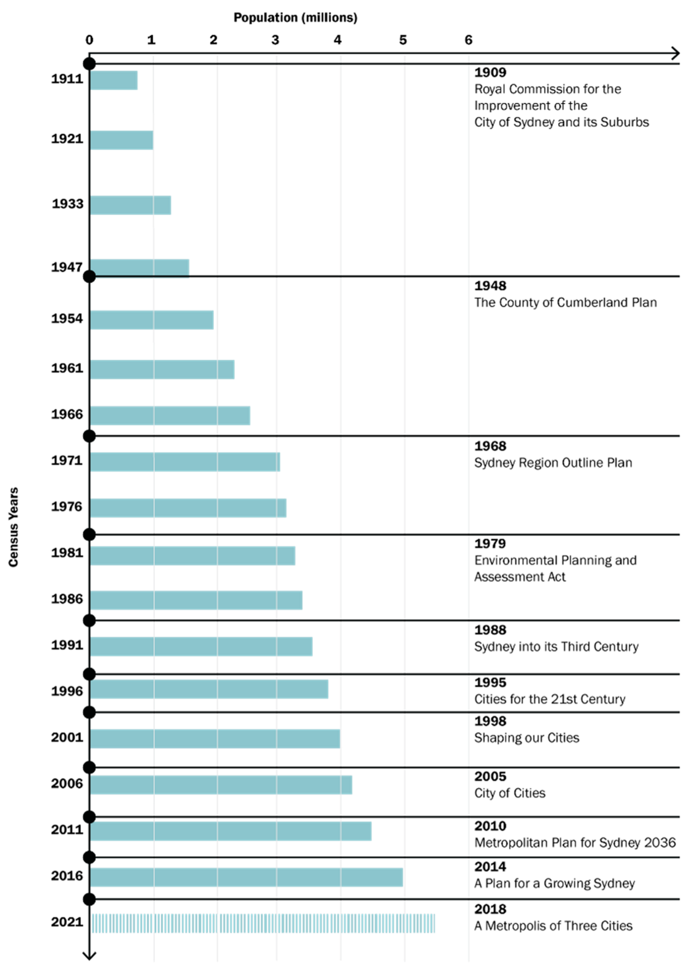

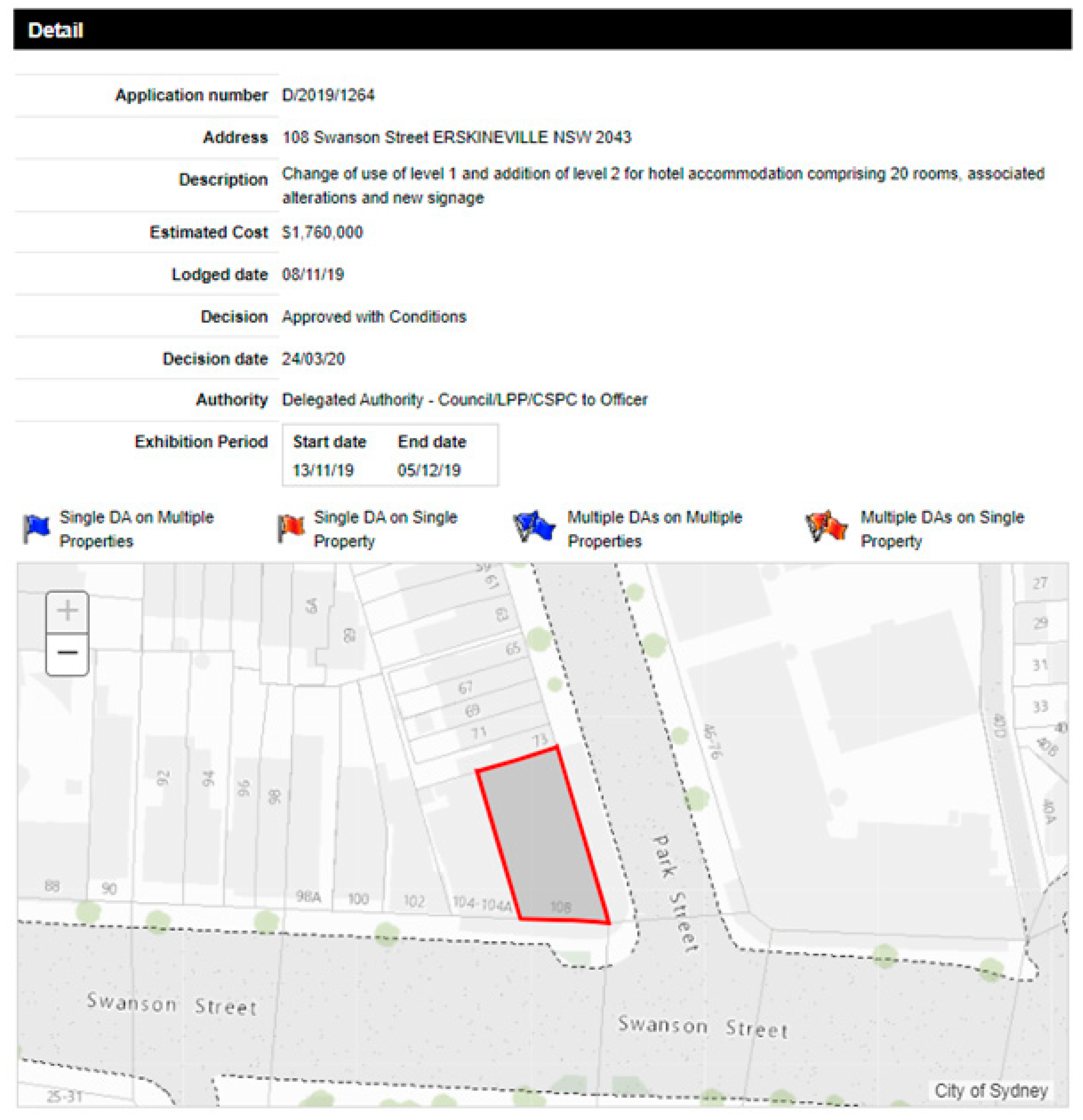


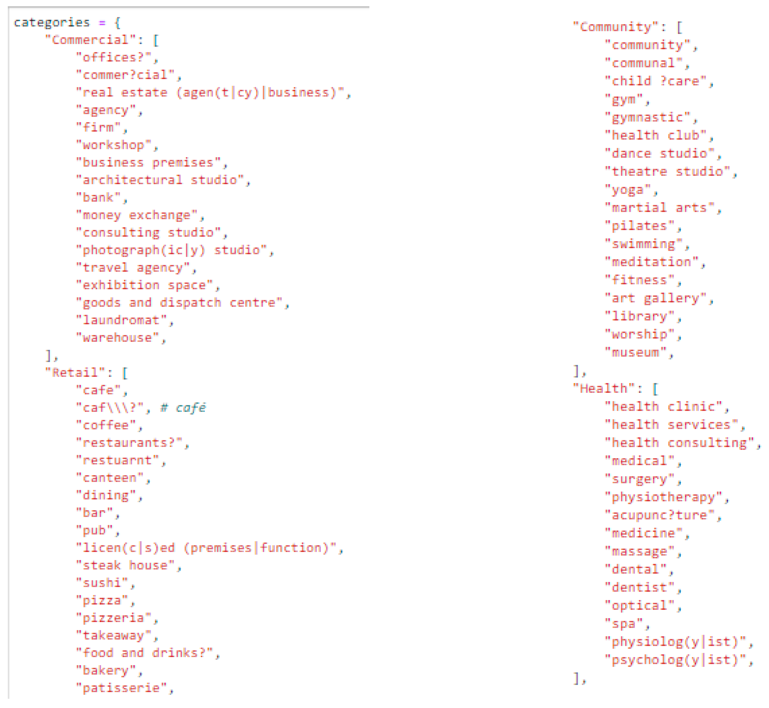
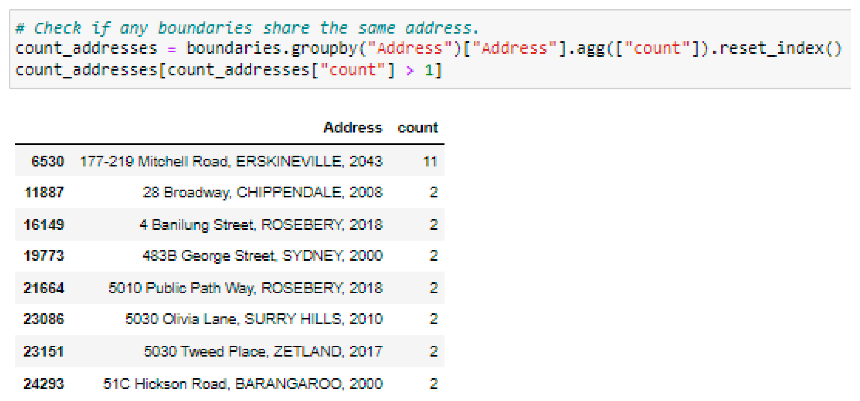
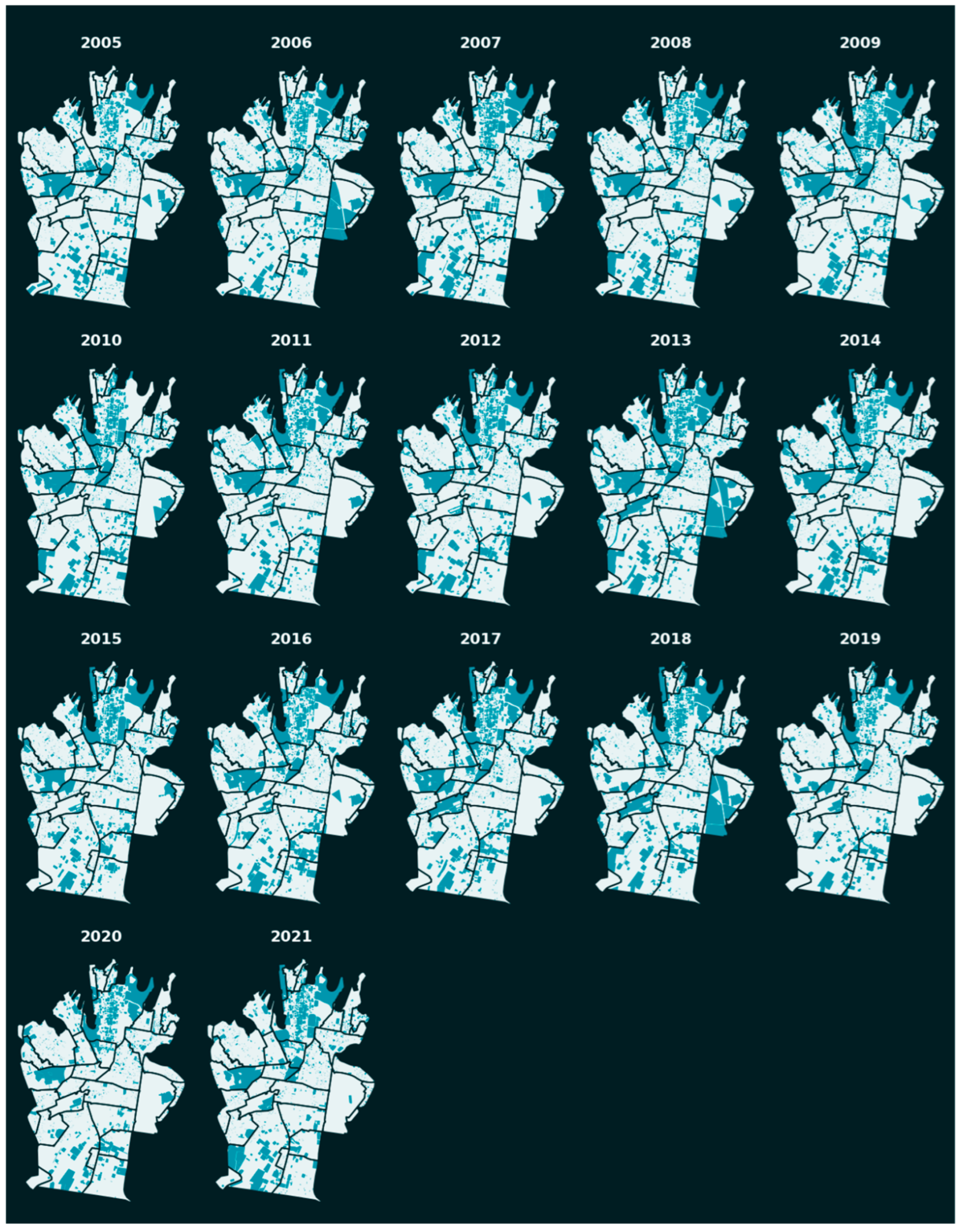


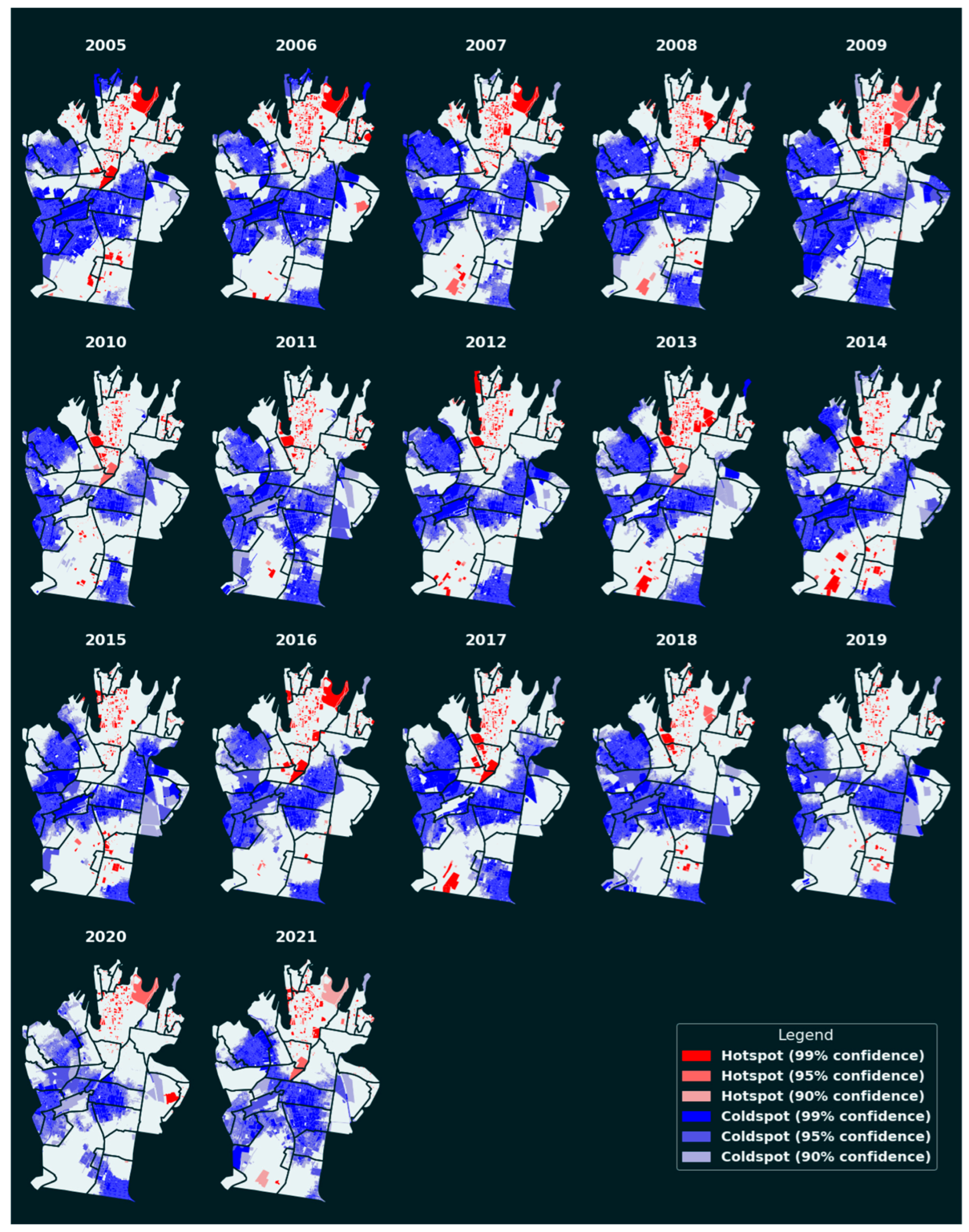


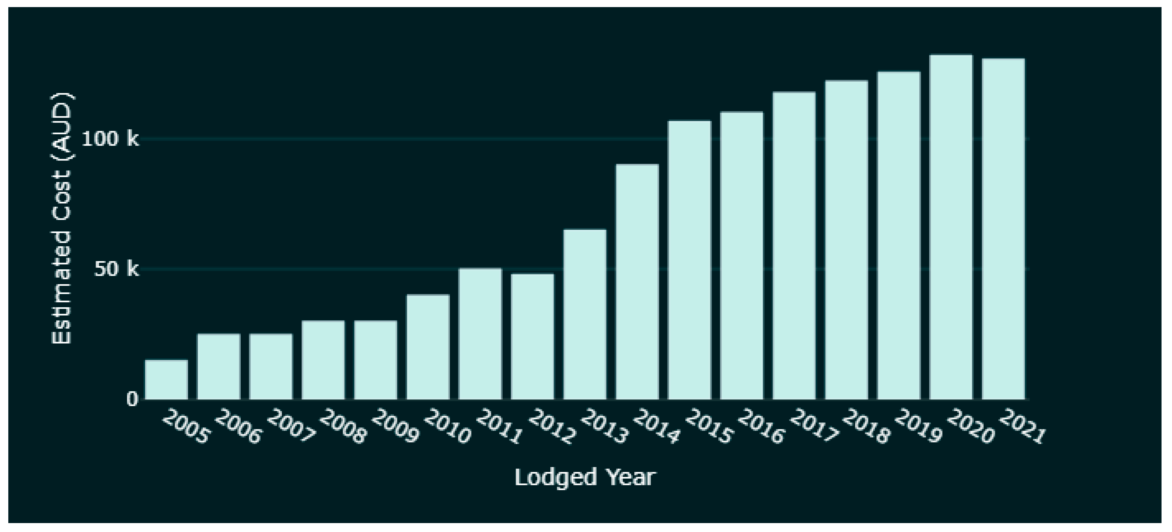

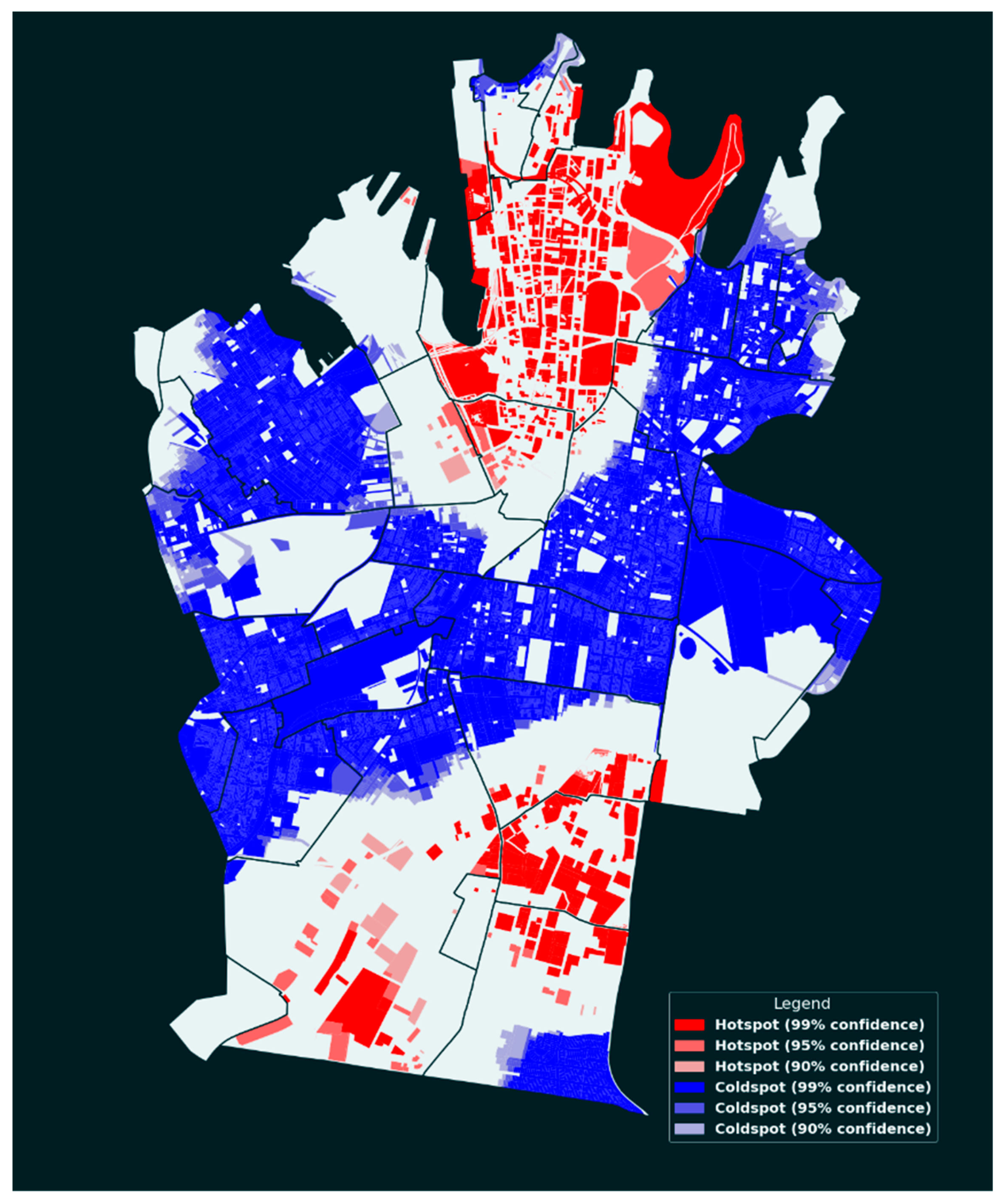







| Research Question | Tool | Method |
|---|---|---|
| What is the spatiotemporal distribution of developments? | Python | Bar charts, linear charts, location mapping, hot and cold spot analysis, space time cube |
| Is there a spatiotemporal pattern of development spending? | Python | Bar charts, pie charts, linear charts, scatter plots, hot and cold spot analysis, quintile distribution mapping |
| Is there a pattern of evolution in different categories of proposed development use? | Python | Bar charts, pie charts |
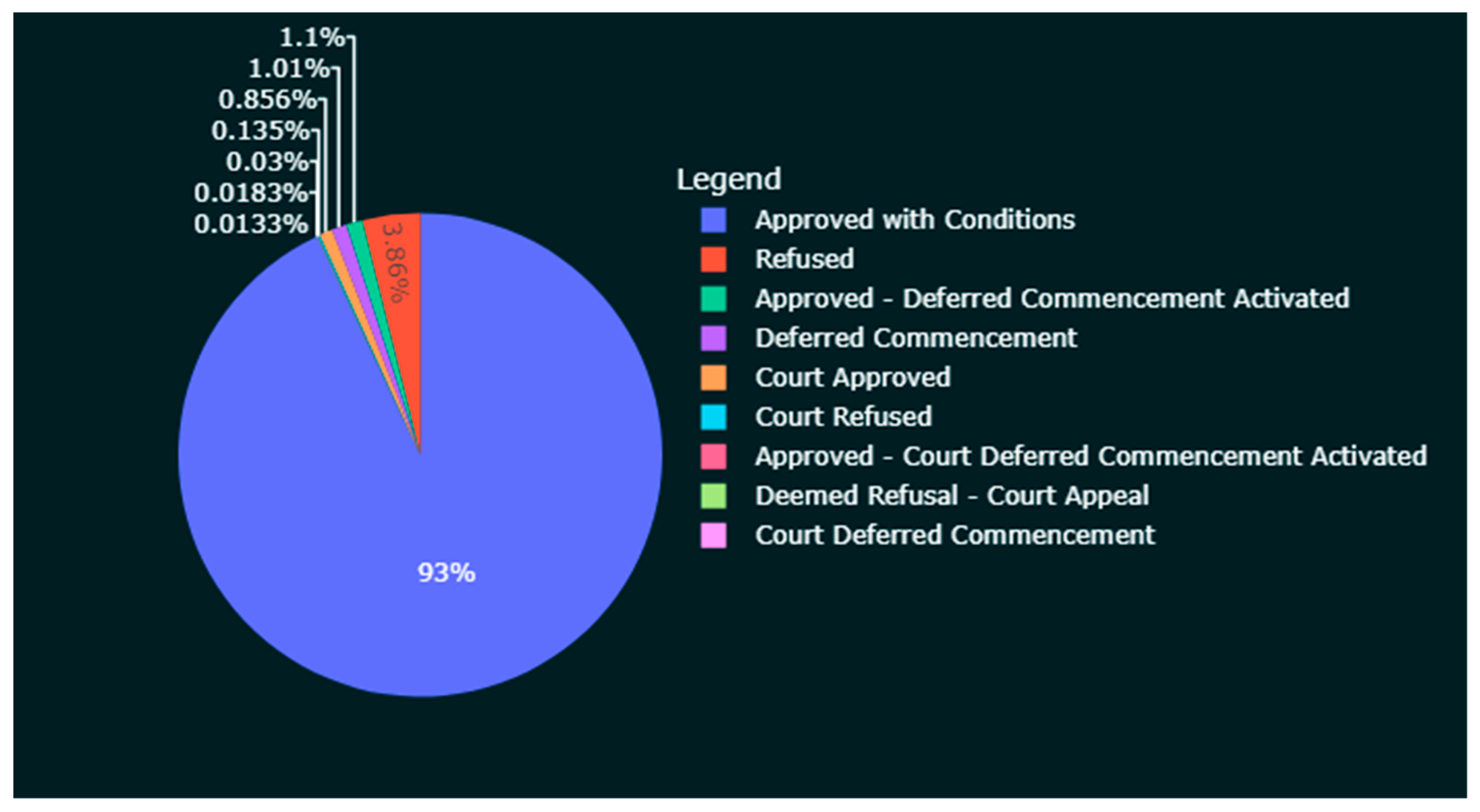
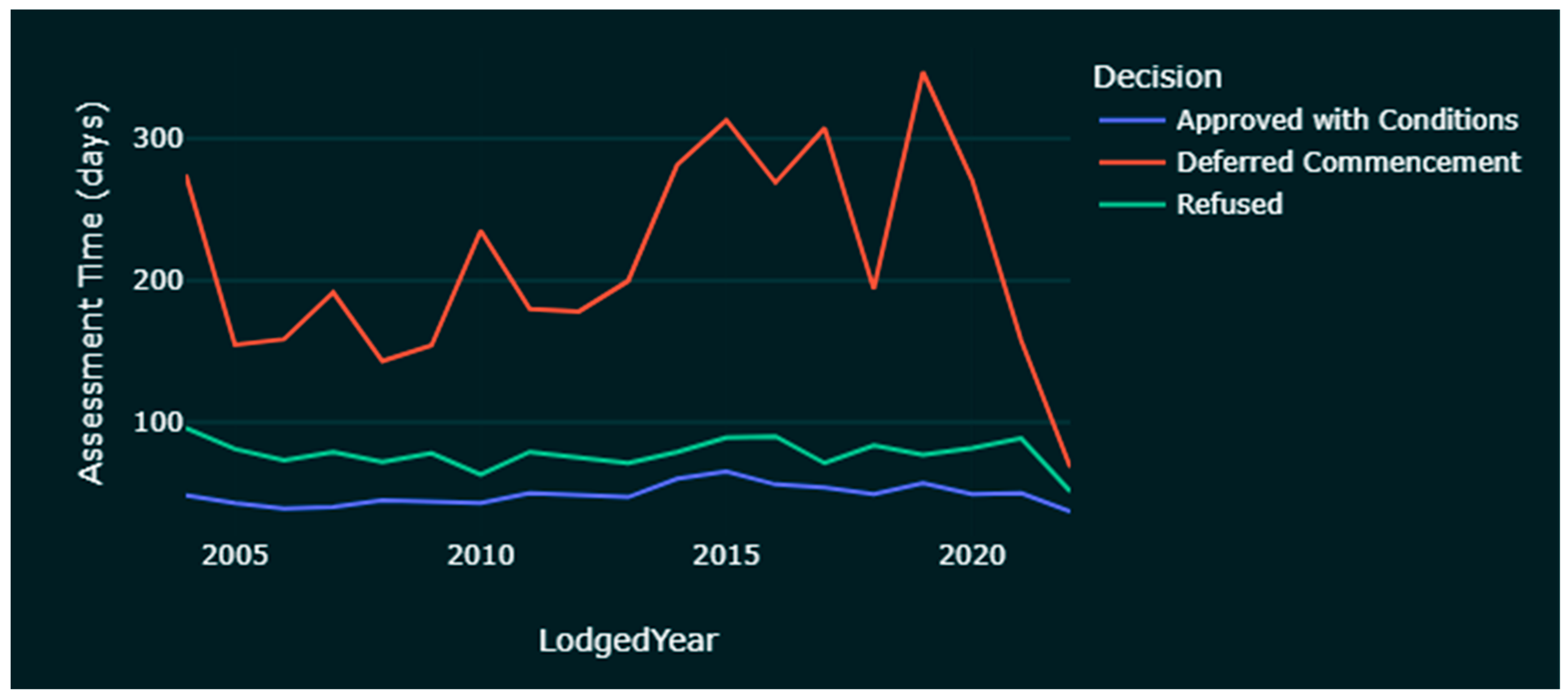
| How do assessment times vary between DAs? | Python | Pie charts, scatter plots, bar charts |
| Description | Data Type | Source | Processing Required |
|---|---|---|---|
| LGA boundary | Shapefile | CoS Data Hub | Import into QGIS and styled |
| NSW suburb/locality boundaries [49] | Shapefile | Data.gov.au | Processed |
| Planning consent authorities | Shapefile | CoS Data Hub | Import into QGIS and styled |
| Property boundaries [50] | Shapefile | CoS Data Hub | Import into QGIS to be joined with other data |
| Background map | WMS | Mapbox | Design in Mapbox and linked into QGIS |
| Field Name | Description | Sample Value | Comments |
|---|---|---|---|
| App Number | DA number Development type/lodgement year/development number/subsequent development series number | D/2021/267 DU/2002/952/A | Can be used to identify related applications. |
| Address | Full address | 84–110 Castlereagh Street\rSYDNEY NSW 2000 | Needs cleaning up of the ‘\r’ string. Sometimes, geocoding can have an issue processing addresses with a hyphen between numbers |
| Street | Street address | Castlereagh Street | Not used as it overlaps with ‘Address’ field |
| Suburb | Suburb | ALEXANDRIA | Allows quick sorting of DAs into different suburbs for comparison |
| Description | Brief summary of DA | Demolition of the former Ryvita Factory and construction of a new, mixed use development comprising nine (9) interlinked buildings and the transfer of land at 19–25 Lyons Road, Camperdown to Council for community purposes. | Contains key information about the DA but needs to be extracted |
| Lodged Date | Date of lodgement | 23 March 2021 | Used to calculate the whole decision timeframe |
| Exhibition Closed Date | Date of exhibition closure | 16 December 2004 | Not used |
| Decision | Description of decision | ‘Approved with Conditions’, ‘Refused’ | Used to understand if the DA is approved or not |
| Officer | Names of DA officers | Names not to be shown | Not used |
| Est Cost | Estimated cost of DA | $3,919,948 | Needs to be cleaned up and converted to numbers |
| Decision Date | Date of decision | 13 September 2005 | Used to calculate the whole decision timeframe |
| On Exhibition | If the DA is still on exhibition | Empty or ‘Yes’ | Used to exclude DAs where no decision is made yet |
Publisher’s Note: MDPI stays neutral with regard to jurisdictional claims in published maps and institutional affiliations. |
© 2022 by the authors. Licensee MDPI, Basel, Switzerland. This article is an open access article distributed under the terms and conditions of the Creative Commons Attribution (CC BY) license (https://creativecommons.org/licenses/by/4.0/).
Share and Cite
Zhu, Z.; Shirowzhan, S.; Pettit, C.J. Investigation of Development Applications: A GIS Based Spatiotemporal Analysis in the City of Sydney Area 2004–2022. Buildings 2022, 12, 1601. https://doi.org/10.3390/buildings12101601
Zhu Z, Shirowzhan S, Pettit CJ. Investigation of Development Applications: A GIS Based Spatiotemporal Analysis in the City of Sydney Area 2004–2022. Buildings. 2022; 12(10):1601. https://doi.org/10.3390/buildings12101601
Chicago/Turabian StyleZhu, Zhiyu, Sara Shirowzhan, and Christopher James Pettit. 2022. "Investigation of Development Applications: A GIS Based Spatiotemporal Analysis in the City of Sydney Area 2004–2022" Buildings 12, no. 10: 1601. https://doi.org/10.3390/buildings12101601
APA StyleZhu, Z., Shirowzhan, S., & Pettit, C. J. (2022). Investigation of Development Applications: A GIS Based Spatiotemporal Analysis in the City of Sydney Area 2004–2022. Buildings, 12(10), 1601. https://doi.org/10.3390/buildings12101601


