Architectural Survey, Diagnostic, and Constructive Analysis Strategies for Monumental Preservation of Cultural Heritage and Sustainable Management of Tourism
Abstract
:1. Introduction
1.1. Definition of the Conceptual Framework of the Research
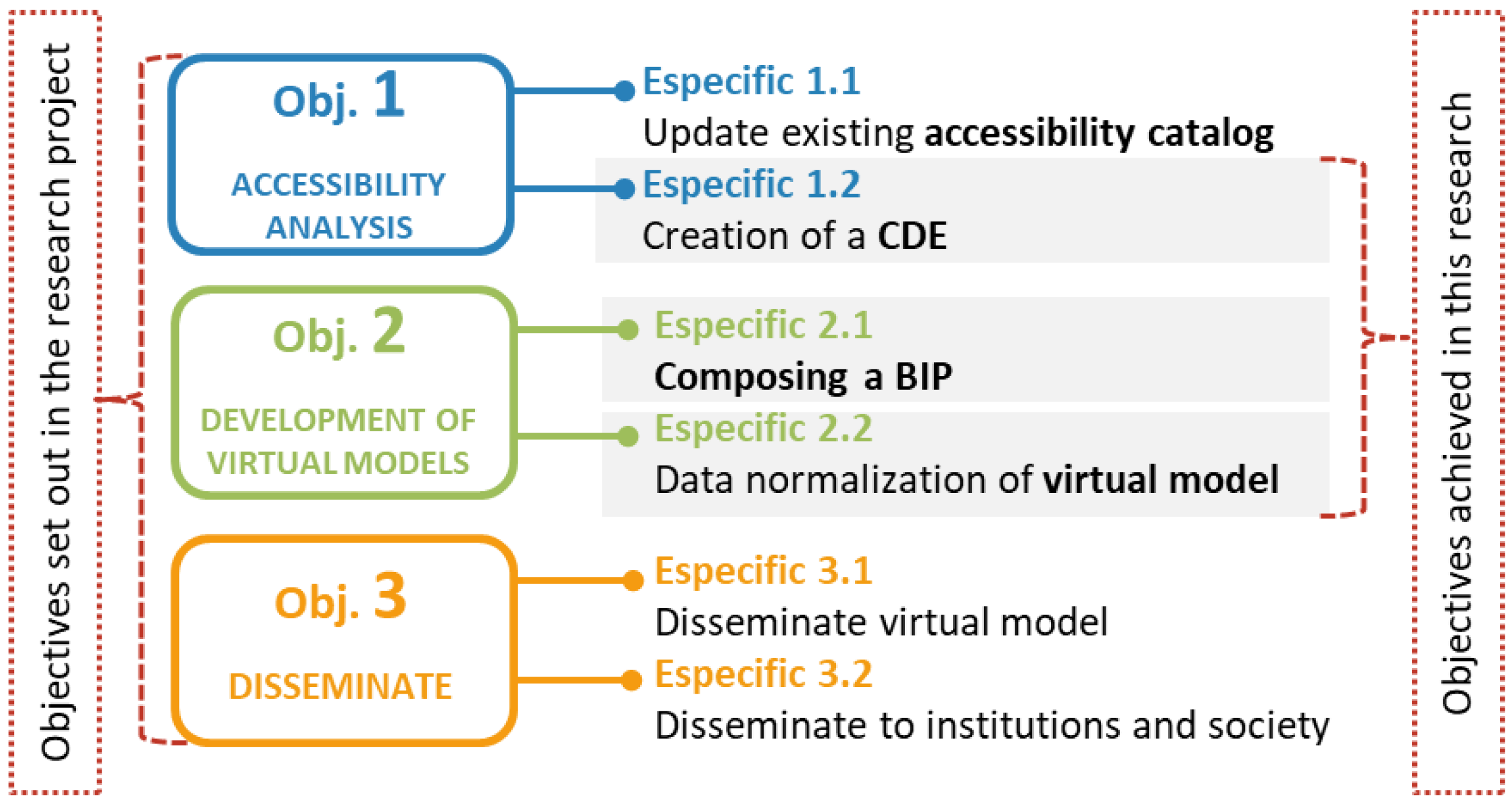
- To draw up a gradient of accessibility in the Archaeological Heritage of Public Buildings from the Roman period within the city of Mérida including, for the first time, all of the buildings, buried buildings, areas closed to the public, and those in danger of ruin or destruction.
- Elaborate a methodology for the creation and development of virtual 6D models of the most vulnerable architectural heritage due to its high tourist impact for its virtual reconstruction.
- Transmit to society, the scientific community, and institutions that the virtualisation of heritage is necessary for the comprehension of a more efficient and sustainable tourism.
- 1.2
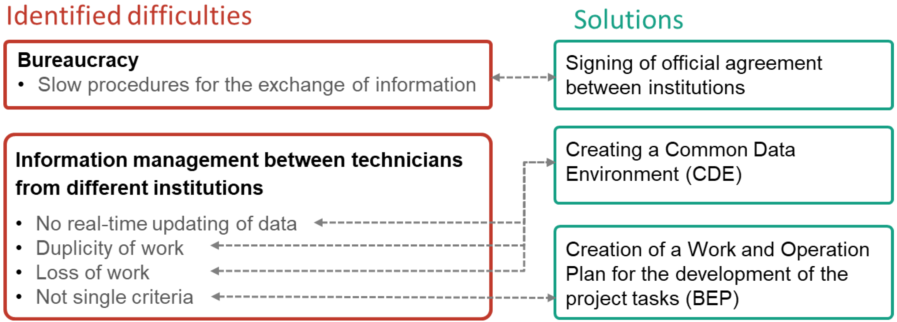
- The creation of a HBIM Common Data Environment between the University of Extremadura and the Consortium of Mérida for the real-time consultation of models and information related to heritage.
- 2.1
- The integration of a BIP (BIM implementation plan) at both institutions as a BIM implementation guide for virtual reconstructions.
- 2.2
- The creation of 6D models of the specific settlements with three types of highly accurate non-invasive techniques complementing the historical and archaeological work of the team.
1.2. Research Team
1.3. Definition of the Project Context: The City of Merida as a Pilot Site for the Research
1.4. Collaboration between Institutions
1.5. Applicability
2. Background and Related Works
3. Materials and Methods
- The study and analysis of the impact of tourism on the city of Mérida and its effect on archaeological heritage.
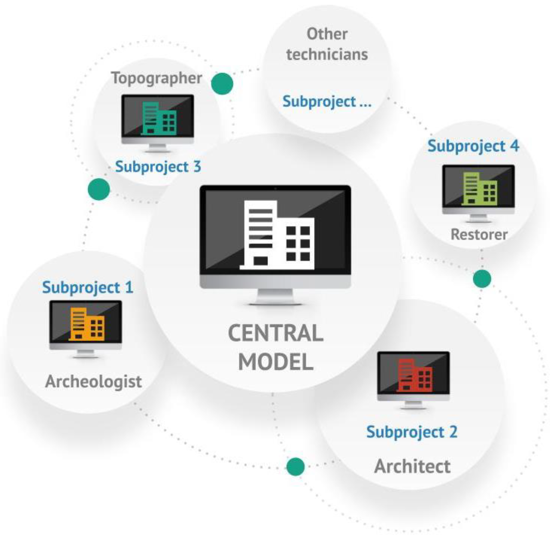
- The creation of a Common Data Environment between the University of Extremadura and the Consorcio of Mérida that favours communication between the specialists involved in heritage management.
- The protocolisation of the use of non-invasive techniques in tourism development projects in the city of Mérida, in order to adapt them to both on-site and virtual visits.
3.1. Phase 1: Previous Analysis of the City as a Tourist Attraction
Analysis of Data on Tourism Activity in Mérida
3.2. Phase 2: Definition of a Collaborative Protocol within an ECD (Common Data Environment) That Will Be Developed throughout the Project
3.2.1. Creation of a SERVER COMMON to Both Collaborating Entities, So That Any Progress in the Research Can Be Transmitted in Real-Time to Any Member of the Research Team
- Server Structure
3.2.2. Drawing up a Work and Operation Plan for the Development of the Project’s Tasks
- Establishing a strategy
- Selection and configuration of the tools to be used
- To describe the storage of the model in the programme as well as the delivery format of the model;
- To establish the model or part of the model for each discipline;
- To mark what minimum information the model should have;
- To describe the quality control model;
- To establish the coordinates of the project.
- Data management system
- The structure of the work folders and files. A template was established describing the structure of each of the folders where all the project data will be stored (Table 3);
- The standardised nomenclature for the folders and files;
- The print style;
- Input data collection: Data collection was classified by themes or disciplines. All data must be geo-referenced and sufficiently defined to be able to develop the model.
- Protocolisation of the formats for data exchange.
- Communication methods and use of standardised tools.
3.3. Phase 3: Use of Non-Invasive Technologies and Instrumentation for Heritage Management
- Preservation of buried archaeological features using GPR
- Prior calibration of the equipment, using the test bench built at the Polytechnic School of Cáceres, which consists of an enclosed area in which different strata of soil (sandy, slate, and granite) were distributed and different objects of known dimensions and locations and depths (pipes, cables, walls, etc.) were buried.
- In each settlement of interest, surveys were carried out in orthogonal directions to each other, in order to have a grid of radargrams that would allow us to carry out an adequate interpretation of these and to elaborate a model of the subsoil structure at each site. For a better visualisation of the radargrams, different filters were used during processing to improve the signal-to-noise ratio: the band-pass filter, gain filter, and background subtraction filter (Figure 8).
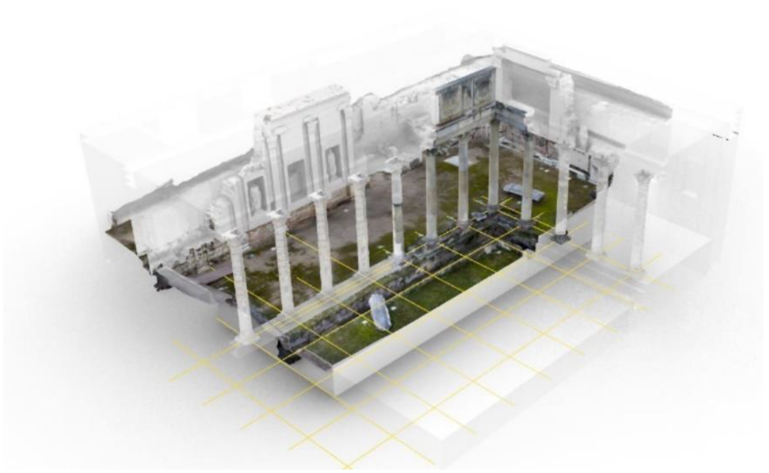
- Data collection through the use of UAV and RPAS technologies
- -
- Inspection of the study area: Where the morphology and geometry of the settlement or topography (if the buildings are underground) is studied.
- -
- Support and ground control points: In order to take valid photographs for the purpose of a 3D survey with drones, GCP and “Check Points” (support and ground control points) are needed to guide the work to a single reference system. To achieve the accuracy and precision, we require a digital reconstruction work such as the one we wish to tackle, for which we will need a differential GPS or RTK system.
- -
- Drone flight planning and execution: Drone flights must be carefully planned by taking into account the number of flight lines, the speed of the drone, the flight height, and the percentage of overlapping images, among other things.
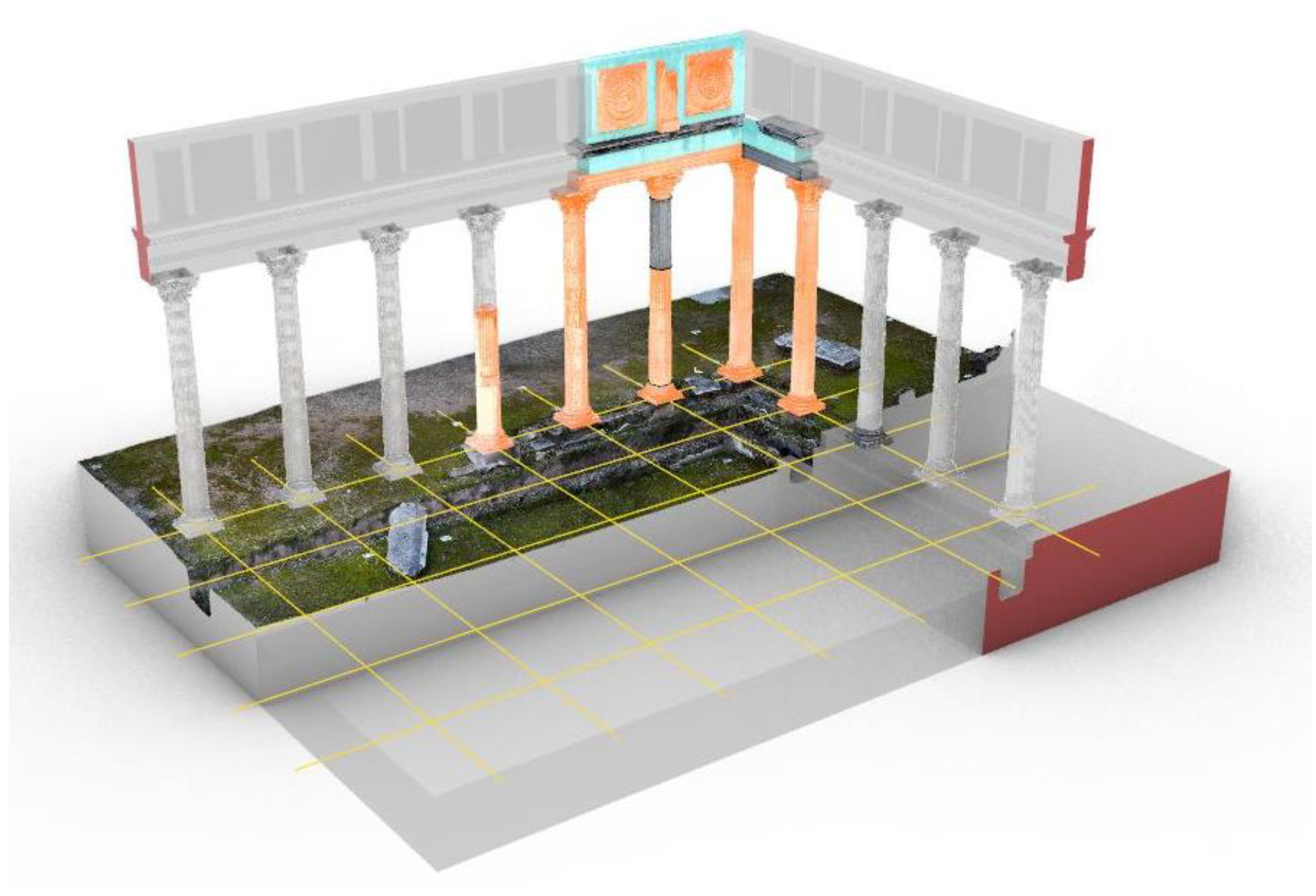
- Creation of the virtual model
- Virtual tour with the use of VR and VRA technologies
4. Results
5. Discussion and Conclusions
Author Contributions
Funding
Data Availability Statement
Acknowledgments
Conflicts of Interest
References
- Sánchez, M.S.O.; García, Y.G.; Ramos Vecino, N. Informe sobre Turismo Urbano. Cáceres y Mérida; Extremadura University: Extremadura, Spain, 2021; p. 126. [Google Scholar]
- Nieto-Julián, J.E.; Lara, L.; Moyano, J. Implementation of a TeamWork-HBIM for the Management and Sustainability of Architectural Heritage. Sustainability 2021, 13, 2161. [Google Scholar] [CrossRef]
- Pelegrín Naranjo, L.; Pelegrín Entenza, N.; Vázquez Pérez, A. An Analysis of Tourism Demand as a Projection from the Destination towards a Sustainable Future: The Case of Trinidad. Sustainability 2022, 14, 5639. [Google Scholar] [CrossRef]
- Ruiz Lanuza, A.; Pulido Fernández, J.I. El impacto del turismo en los Sitios Patrimonio de la Humanidad. Una revisión de las publicaciones científicas de la base de datos Scopus. Pasos Rev. Tur. Patrim. Cult. 2015, 13, 1247–1264. [Google Scholar] [CrossRef]
- Stoica, G.D.; Andreiana, V.-A.; Duica, M.C.; Stefan, M.-C.; Susanu, I.O.; Coman, M.D.; Iancu, D. Perspectives for the Development of Sustainable Cultural Tourism. Sustainability 2022, 14, 5678. [Google Scholar] [CrossRef]
- Roinioti, E.; Pandia, E.; Konstantakis, M.; Skarpelos, Y. Gamification in Tourism: A Design Framework for the TRIPMENTOR Project. Digital 2022, 2, 191–205. [Google Scholar] [CrossRef]
- Jurlin, K. Were Culture and Heritage Important for the Resilience of Tourism in the COVID-19 Pandemic? J. Risk Financ. Manag. 2022, 15, 205. [Google Scholar] [CrossRef]
- Cruz Franco, P.A.; Rueda Marquez de la Plata, A. Tad3lab Models Library. Available online: https://sketchfab.com/TAD3LAB/models (accessed on 6 September 2021).
- Parrinello, S. The virtual reconstruction of the historic districts of Shanghai European identity in traditional Chinese architecture. Disegnarecon 2020, 13, 18.1–18.13. [Google Scholar] [CrossRef]
- Cruz Franco, P.A.; Rueda Marquez de la Plata, A.; Cortés Pérez, J.P. Veinte Siglos de Patrimonio de Extremadura en ocho Puentes. Documentación Digital de las Obras Públicas; Junta de Extremadura; Consejería de Economía e Infraestructuras y Universidad de Extremadura: Extremadura, Spain, 2018; Volume 1, p. 208. [Google Scholar]
- Rodriguez Sánchez, C. Levantamiento y Propuesta de Accesibilidad en el Jardín Histórico de la ARGUIJUELA de ARRIBA (Cáceres); Universidad de Extremadura: Caceres, Spain, 2021. [Google Scholar]
- Cruz Franco, P.A.; Rueda Márquez de la Plata, A. Documentación y estudio de un “agregado” en la Ciudad de Cáceres: Análisis fotogramétrico y gráfico. In Proceedings of the Congreso Internacional sobre Documentación, Conservación y Reutilización del Patrimonio Arquitectónico, Madrid, Spain, 18–21 October 2017. [Google Scholar]
- Saura-Gómez, P.; Spairani-Berrio, Y.; Huesca-Tortosa, J.A.; Spairani-Berrio, S.; Rizo-Maestre, C. Advances in the Restoration of Buildings with LIDAR Technology and 3D Reconstruction: Forged and Vaults of the Refectory of Santo Domingo de Orihuela (16th Century). Appl. Sci. 2021, 11, 8541. [Google Scholar] [CrossRef]
- Cruz Franco, P.A.; Rueda Márquez de la Plata, A.; Cruz Franco, J. From the Point Cloud to BIM Methodology for the Ideal Reconstruction of a Lost Bastion of the Cáceres Wall. Appl. Sci. 2020, 10, 6609. [Google Scholar] [CrossRef]
- Ramos Sánchez, J.A. Utilización de la Metodología BIM en la gestión del patrimonio arqueológico. In Caso de Estudio el Recinto Arqueológico de los llamados Columbarios de Merida; Universidad de Extremadura: Caceres, Spain, 2021. [Google Scholar]
- Demetrescu, E.; Ferdani, D. From Field Archaeology to Virtual Reconstruction: A Five Steps Method Using the Extended Matrix. Appl. Sci. 2021, 11, 5206. [Google Scholar] [CrossRef]
- Gisbert Santaballa, A.G. La arqueología virtual como herramienta didáctica y motivadora. Tecnol. Cienc. Educ. 2019, 13, 119–147. [Google Scholar] [CrossRef]
- Monterroso-Checa, A.R.-V.A.; Gasparini, M.; Hornero, A.; Iraci, B.; Martín-alaverano, R.; Moreno-Escribano, J.C.; Muñoz-Cádiz, J.; Murillo-Fragero, J.I.; Obregón-Romero, R.; Vargas, N.; et al. A heritage science workflow to preserve and narrate a rural archeological landscape using virtual reality: The cerro del castillo of belmez and its surrounding environment (Cordoba, Spain). Appl. Sci. 2020, 10, 8659. [Google Scholar] [CrossRef]
- Parrinello, S.; Dell’Amico, A. Experience of Documentation for the Accessibility of Widespread Cultural Heritage. Heritage 2019, 2, 1032–1044. [Google Scholar] [CrossRef] [Green Version]
- Parrinello, S.; Morandotti, M.; Valenti, G.; Piveta, M.; Basso, A.; Inzerillo, A.; Lo Turco, M.; Picchio, F.; Santagati, C. Digital & Documentation: Databases and Models for the Enhancement of Heritage; Parrinello, S., Ed.; Edizioni dell’Università degli Studi di Pavia: Pavia, Italy, 2019; Volume 1. [Google Scholar]
- Paris, L.; Rossi, M.L.; Cipriani, G. Modeling as a Critical Process of Knowledge: Survey of Buildings in a State of Ruin. ISPRS Int. J. Geo-Inf. 2022, 11, 172. [Google Scholar] [CrossRef]
- Ramos Sánchez, J.A.; Cruz Franco, P.A.; Rueda Márquez de la Plata, A. Achieving Universal Accessibility through Remote Virtualization and Digitization of Complex Archaeological Features: A Graphic and Constructive Study of the Columbarios of Merida. Remote Sens. 2022, 14, 3319. [Google Scholar] [CrossRef]
- Intignano, M.; Biancardo, S.A.; Oreto, C.; Viscione, N.; Veropalumbo, R.; Russo, F.; Ausiello, G.; Dell’Acqua, G. A Scan-to-BIM Methodology Applied to Stone Pavements in Archaeological Sites. Heritage 2021, 4, 3032–3049. [Google Scholar] [CrossRef]
- Parrinello, S.; Francesca, P.; Dell’Amico, A.; De Marco, R. Prometheus. protocols for information models libraries tested on heritage of upper kama sites. msca rise 2018. In II Simposio UID di Internazionalizzazione Della Ricerca. Patrimoni Culturali, Architettura, Paesaggio e Design tra Ricerca e Sperimentazione Didattica; DIDA: Firenze, Italy, 2019. [Google Scholar]
- Parrinello, S.; Picchio, F. Integration and Comparison of Close-Range Sfm Methodologies for the Analysis and the Development of the Historical City Center of Bethlehem. ISPRS Int. Arch. Photogramm. Remote Sens. Spat. Inf. Sci. 2019, XLII-2/W9, 589–595. [Google Scholar] [CrossRef] [Green Version]
- Parrinello, S.; Picchio, F.; De Marco, R.; Dell’Amico, A. Documenting the Cultural Heritage Routes. The Creation of Informative Models of Historical Russian Churches on Upper Kama Region. ISPRS Int. Arch. Photogramm. Remote Sens. Spat. Inf. Sci. 2019, XLII-2/W15, 887–894. [Google Scholar] [CrossRef] [Green Version]
- Parrinello, S.; Porzilli, S. Rilievo Laser Scanner 3D per l’analisi morfologica e il monitoraggio strutturale di alcuni ambienti inseriti nel progetto di ampliamento del complesso museale degli Uffizi a Firenze. In Reuso 2016: Contributi per la Documentazione, Conservazione e Recupero del Patrimonio Architettonico e per la Tutela Paesaggistica; ReUso: Pavia, Italy, 2016. [Google Scholar]
- Pensieri, M.G.; Garau, M.; Barone, P.M. Drones as an Integral Part of Remote Sensing Technologies to Help Missing People. Drones 2020, 4, 15. [Google Scholar] [CrossRef]
- Blasco Senabre, J.; Varea, S.; Cotino Vila, F.; Ribera Lacomba, A.; García Puchol, O. Procesos de documentación arqueológica y generación de modelos virtuales. Virtual Archaeol. Rev. 2011, 2, 65–69. [Google Scholar] [CrossRef]
- Tsilimantou, E.; Delegou, E.T.; Nikitakos, I.A.; Ioannidis, C.; Moropoulou, A. GIS and BIM as Integrated Digital Environments for Modeling and Monitoring of Historic Buildings. Appl. Sci. 2020, 10, 1078. [Google Scholar] [CrossRef] [Green Version]
- Rueda Marquez de la Plata, A.; Cruz Franco, P.A.; Cruz Franco, J.; Gibello Bravo, V. Protocol Development for Point Clouds, Triangulated Meshes and Parametric Model Acquisition and Integration in an HBIM Workflow for Change Control and Management in a UNESCO’s World Heritage Site. Sensors 2021, 21, 1083. [Google Scholar] [CrossRef] [PubMed]
- Bruno, N.; Roncella, R. A Restoration Oriented Hbim System for Cultural Heritage Documentation: The Case Study of Parma Cathedral. ISPRS—Int. Arch. Photogramm. Remote Sens. Spat. Inf. Sci. 2018, XLII-2, 171–178. [Google Scholar] [CrossRef] [Green Version]
- Bruno, N.; Roncella, R. HBIM for Conservation: A New Proposal for Information Modeling. Remote Sens. 2019, 11, 1751. [Google Scholar] [CrossRef] [Green Version]
- Gómez Robles, L.; Quirosa García, V. Nuevas Tecnologías para Difundir el Patrimonio Cultural: Las Reconstrucciones Virtuales en España; erph_ Revista electrónica de Patrimonio Histórico: Granada, Spain, 2015. [Google Scholar]
- Stanley Price, N.P.E.A. La conservacion en Excavaciones Arqueológicas; ICCROM: Rome, Italy, 1984. [Google Scholar]
- Alfio, V.S.; Costantino, D.; Pepe, M. Influence of Image TIFF Format and JPEG Compression Level in the Accuracy of the 3D Model and Quality of the Orthophoto in UAV Photogrammetry. J. Imaging 2020, 6, 30. [Google Scholar] [CrossRef] [PubMed]
- Azmi, M.A.A.M.; Abbas, M.A.; Zainuddin, K.; Mustafar, M.A.; Zainal, M.Z.; Majid, Z.; Idris, K.M.; Ari, M.F.M.; Luh, L.C.; Aspuri, A. 3D Data Fusion Using Unmanned Aerial Vehicle (UAV) Photogrammetry and Terrestrial Laser Scanner (TLS). In Proceedings of the Second International Conference on the Future of ASEAN (ICoFA), Singapore, 13–15 May 2017; pp. 295–305. [Google Scholar]
- Murtiyoso, A.; Grussenmeyer, P. Documentation of heritage buildings using close-range UAV images: Dense matching issues, comparison and case studies. Photogramm. Rec. 2017, 32, 206–229. [Google Scholar] [CrossRef] [Green Version]
- Xu, Z.; Wu, L.; Shen, Y.; Li, F.; Wang, Q.; Wang, R. Tridimensional Reconstruction Applied to Cultural Heritage with the Use of Camera-Equipped UAV and Terrestrial Laser Scanner. Remote Sens. 2014, 6, 10413–10434. [Google Scholar] [CrossRef] [Green Version]
- Lee, U.-K. Tourism Using Virtual Reality: Media Richness and Information System Successes. Sustainability 2022, 14, 3975. [Google Scholar] [CrossRef]
- Lee, H.; Hwang, Y. Technology-Enhanced Education through VR-Making and Metaverse-Linking to Foster Teacher Readiness and Sustainable Learning. Sustainability 2022, 14, 4786. [Google Scholar] [CrossRef]
- Moreno Sánchez, P. Técnicas BIM Aplicadas a la Reconstrucción 3D del Yacimiento Arqueológico MLEIHA-6 (EAU); Universidad Politécnica de Madrid: Madrid, Spain, 2016. [Google Scholar]
- Abdelhafiz, A.; Hassan, T. Two points registration algorithm for terrestrial laser scanner point clouds. Surv. Rev. 2019, 51, 238–243. [Google Scholar] [CrossRef]
- McKay, P.J.B.A.H.D. A method for registration of 3-d shapes. IEEE Pattern Anal. Mach. Intell. 1992, 14, 239–256. [Google Scholar]
- Remondino, F.A.E.H.S. Modelado 3D basado en imágenes: Una revisión. Photogramm. Rec. 2006, 21, 269–291. [Google Scholar] [CrossRef]
- Rodríguez-Moreno, C.; Reinoso-Gordo, J.F.; Rivas-López, E.; Gómez-Blanco, A.; Ariza-López, F.J.; Ariza-López, I. From point cloud to BIM: An integrated workflow for documentation, research and modelling of architectural heritage. Surv. Rev. 2018, 50, 212–231. [Google Scholar] [CrossRef]
- Rodriguez-Martin, M.; Rodriguez-Gonzalvez, P. Suitability of Automatic Photogrammetric Reconstruction Configurations for Small Archaeological Remains. Sensors 2020, 20, 2936. [Google Scholar] [CrossRef]
- Banfi, F. The Evolution of Interactivity, Immersion and Interoperability in HBIM: Digital Model Uses, VR and AR for Built Cultural Heritage. ISPRS Int. J. Geo-Inf. 2021, 10, 685. [Google Scholar] [CrossRef]
- Guerrero Vega, J.M.; Pizzo, A. Análisis arquitectónico y aplicación de metodología BIM en el santuario extraurbano de Tusculum. Archeol. Calc. 2021, 32, 99–116. [Google Scholar] [CrossRef]
- Ayerbe Vélez, R.; Barrientos Vera, T.; Palma García, F. El Foro de Augusta Emerita. Génesis y Evolución de sus Recintos Monuentales; Consejo Superior de Investigaciones Cientificas: Mérida, Mexico, 2009. [Google Scholar]
- De Marco, R.; Parrinello, S. Management of Mesh Features in 3d Reality-Based Polygonal Models to Support Non-Invasive Structural Diagnosis and Emergency Analysis in the Context of Earthquake Heritage in Italy. Int. Arch. Photogramm. Remote Sens. Spat. Inf. Sci. 2021, XLVI-M-1-2021, 173–180. [Google Scholar] [CrossRef]



| Data Extracted from the National Statistics Institute (INE) | |
|---|---|
| Total tourists in the year 2018 | 287.208 |
| Foreign tourists | 65.161 (23%) |
| Spanish tourists | 222.047 (77%) |
| Number of overnight stays | 424.159 |
| Average stay in days | 1.48 |
| N° | Hito | Deliverable | Start Date | Delivery Date |
|---|---|---|---|---|
| F1 | Organisation of work and existing documentation | |||
| Diagnosis | .doc | - | - | |
| Project objective | .doc | - | - | |
| Development of BEP | .doc | - | - | |
| Historical-archaeological documentation | - | - | ||
| Preliminary graphic documentation | .dwg/.jpg | - | - | |
| F2 | Survey. BIM model | |||
| Data collection | .jpg | - | - | |
| Point cloud generation of the buildings | .rcp | - | - | |
| Point cloud generation of the topography | .rcs | - | - | |
| Modelling of archaeological remains | .rvt | - | - | |
| Modelling of the topography | .rvt | - | - | |
| Implementation of the qualitative information in the model. | .rvt | - | - | |
| Implementation of the pathology of the building. | .rvt | - | - | |
| Implementation of the archaeological information. | .rvt | - | - | |
| F3 | Dissemination | |||
| Images | .jpg | - | - | |
| Videos | .mp4 | - | - | |
| Virtual model online platform | - | - | ||
| File Nomenclature | Content |
|---|---|
| 01_ BUILDING_DOCUMENTATION.PREVIOUS 01.01_ INF.DOCUMENTATION_PDF/JPG 01.02_PRELIMINARY-SURVEYING-PREVIOUS_CAD | It shall contain all of the necessary background information |
| 02_ BUILDING_CAPTURE.DATA | The measurements obtained in the field as well as the photographs classified by area and dates, will be posted. |
| 03_BUILDING_LIFTING 03.01_BUILDINGS 01_EDIF_NP_META 02_EDIF_NP_META.EXP 03_EDIF_NP.PROC_RECAP 04_EDIF_NP.PROC_RECAP.EXP 03.02_TOPOGRAPHY 01_TOPO_NP_META 02_TOPO_NP_META.EXP 03_TOPO_NP.PROC_RECAP 04_TOPO_NP.PROC _RECAP.EXP 05_ TOPO_CN-SUPERF_CIVIL3D | It will host the point cloud files. |
| 04_BUILDING_MODEL 04.01_RVT 04.02_RFA | The files generated with Revit, the families, and the drawings obtained will be included. |
| 05_BUILDING_PROYECTO 05.01_RVT 05.02_RFA 05.02_PLANS | The files generated with Revit, the families, and the drawings obtained will be included. |
| 06_BUILDING_VIRTUALIZACIÓN 06.01_PICTURES_LUM 06.02_VIDEOS_LUM 06.03_MODEL_ | It will contain all files related to the dissemination of the property. |
| 07_BUILDING_MEMORIA 07.01_MEMORY_DOC 07.02_BIBLIOGRAPHY_DOC 07.03_BEP_DOC | The report of the work will be included. |
| N° | Meeting Coordinator |
|---|---|
| Phase 1 | |
| Strategies, objectives and needs. | Management of the Consorcio |
| Documentation and preliminary studies | Documentation Department Coordinator BIM Manager |
| Phase 2 | |
| Data capture in the field | Documentation Department Coordinator BIM Manager |
| Survey | BIM Manager |
| Modelling | BIM Manager |
| Implementation of the qualitative information in the model | BIM Manager |
| Implementation of the pathology of the building. | Coordinator of the Conservation Department |
| Implementation of archaeological information. | Archaeologist |
| Phase 3 | |
| Virtual Tour with the use of VR and VRA | BIM Manager Coordinator of the Dissemination Department |
Publisher’s Note: MDPI stays neutral with regard to jurisdictional claims in published maps and institutional affiliations. |
© 2022 by the authors. Licensee MDPI, Basel, Switzerland. This article is an open access article distributed under the terms and conditions of the Creative Commons Attribution (CC BY) license (https://creativecommons.org/licenses/by/4.0/).
Share and Cite
Rueda Márquez de la Plata, A.; Cruz Franco, P.A.; Ramos Sánchez, J.A. Architectural Survey, Diagnostic, and Constructive Analysis Strategies for Monumental Preservation of Cultural Heritage and Sustainable Management of Tourism. Buildings 2022, 12, 1156. https://doi.org/10.3390/buildings12081156
Rueda Márquez de la Plata A, Cruz Franco PA, Ramos Sánchez JA. Architectural Survey, Diagnostic, and Constructive Analysis Strategies for Monumental Preservation of Cultural Heritage and Sustainable Management of Tourism. Buildings. 2022; 12(8):1156. https://doi.org/10.3390/buildings12081156
Chicago/Turabian StyleRueda Márquez de la Plata, Adela, Pablo Alejandro Cruz Franco, and Jorge Alberto Ramos Sánchez. 2022. "Architectural Survey, Diagnostic, and Constructive Analysis Strategies for Monumental Preservation of Cultural Heritage and Sustainable Management of Tourism" Buildings 12, no. 8: 1156. https://doi.org/10.3390/buildings12081156
APA StyleRueda Márquez de la Plata, A., Cruz Franco, P. A., & Ramos Sánchez, J. A. (2022). Architectural Survey, Diagnostic, and Constructive Analysis Strategies for Monumental Preservation of Cultural Heritage and Sustainable Management of Tourism. Buildings, 12(8), 1156. https://doi.org/10.3390/buildings12081156


