1. Introduction
Urbanisation has been one of the most important drivers of global growth. More than half of the world’s population presently lives in cities, a number expected to rise to 70% by 2050 [
1]. While urbanisation is advancing the global economy, growing inequality inside cities has the potential to stymie growth [
2]. The international community of urban researchers, planners, and designers have recognised the importance of creating more inclusive cities and ensuring that all people benefit from well-planned urbanisation. The World Bank’s dual aims of eradicating extreme poverty and achieving shared prosperity put inclusion at the forefront [
3]. Similarly, The UN-Habitat has proposed a stand-alone goal for cities and urban development in the 2030 Agenda: Sustainable Development Goal 11 (SDG 11), “make cities and human settlements inclusive, safe, resilient and sustainable” [
4]. Despite worldwide recognition and commitment, building inclusive cities remains a big challenge in contemporary society. It is critical to recognise that the notion of inclusive cities encompasses a complex web of multiple spatial, social, and economic aspects in order to ensure that tomorrow’s cities offer opportunities and improved living conditions for all. Spatial inclusion necessitates the provision of affordable needs, including access to vital infrastructure and services, while social inclusion emphasises the need to guarantee the equal rights and participation of all, including the most marginalised [
5,
6]. The spatial and social components of urban inclusion inextricably underpin one another.
Today, one in three people live in residential areas with inadequate facilities and amenities in the developing world [
7]. In developed countries, non-car-based access to essential services for vulnerable and minority demographics can be limited, contributing to significant health, social, and economic issues in these communities [
8].
Designing better walking and wheelchair-friendly environments with good proximity (pedestrian accessibility) to key destinations has social equity benefits for older adults, women, and children. Better walking environments promote autonomous mobility for older people and members of the disability community, greatly improving their independence, mental health, and well-being [
9]. Walking environments which are perceived as safe promote the use of active transport modes for women [
10], school drop off trips made by women with young children, which they do up to four times as often as men [
11,
12], and the unaccompanied school trips of older children which contribute to the development of life-long active transport habits [
12].
However, existing approaches to accessibility modelling have significant limitations. Without accounting for topography, the accessibility model has been constrained to overly simplified and inaccurate circular catchment buffers or sophisticated network buffers generated using geoprocessing routines within geographical information systems, which can be expensive and require a high level of expertise to operate [
13]. For urban designers and policy makers, the significance of this research gap is exacerbated when prompting inclusive city schemes where specific micro-level elements such as a sidewalk slope and cul-de-sacs are to be considered [
14]. To facilitate accessible journeys for all, we argue there is a desperate need to establish a multi-criteria evaluation approach for strategic urban renewal and transformation in the coming decades to promote inclusive, active, and healthy urban communities.
This article highlights both the challenges and opportunities of urban accessibility in regards to health, an ageing population, and an inclusive community, demonstrating key features that have been neglected in the fast urbanisation era. By summarising the prevailing accessibility modelling strategies and applications, we propose a user-friendly analysis and digital design tool, PedestrianCatch, that is immediately relevant to the urban planning and urban design communities, health planners, the disability community, and will be increasingly relevant to the broader community as populations age. We use two case studies, a gated community in Chaoyang, Beijing, China, and an urban renewal project in Maribyrnong, Australia, to test the multi-criteria catchment design and analysis tool. The case studies demonstrate the feasibility, flexibility, and relevance of the approach for evaluating multiple urban design scenarios in radically different contexts. The implementation and adoption of the tool by planners addressing the physical inclusivity of the urban form could potentially contribute to more walkable and accessible communities for all.
2. Accessibility Matters: Challenges and Opportunities
2.1. Accessibility and Health
Physical inactivity is the fourth largest contributor to the global burden of disease [
15] and is a vital consideration when designing future cities. In Australia, overweight and obesity are expected to cost more than AUD 55 billion annually [
16] and has surpassed smoking as the top cause of premature death and illness [
17]. Apart from a considerable discussion and comparison of Australian, European, and US city morphologies in relation to obesity levels [
18,
19], there is also a growing concern about obesity in developing nations experiencing fast urbanisation. For example, China is experiencing a major increase in automobile ownership concurrent with fast urbanisation, and the change from traditional walkable Chinese urbanism to car-dominated urban forms is directly related to rising obesity levels [
20]. Obesity levels are increasing as a result of changing lifestyles (e.g., diet) and, in a large part, due to car use in increasingly inaccessible metropolitan areas [
21,
22].
As cities transform to accommodate population growth and rapid urbanisation [
23], whether through urban densification or lateral expansion, walking and cycling access to destinations such as health services, public open spaces, jobs, education, retail, and public transportation is critical for developing less car-dominated cities. There is a strong association between the built environment’s urban design qualities and residents’ physical activity, with well-connected, accessible street networks supporting walking for transportation and enjoyment [
24,
25]. Cities that encourage walking have been found to decrease the prevalence of non-communicable diseases such as cardiovascular disease, obesity, and type 2 diabetes [
26,
27].
One of the most critical elements affecting walking is proximity to services or points of interest (POI). Residents’ tendency to walk rather than drive is significantly improved if parks, stores, and, notably, public transportation hubs are located within a short walking distance of their residences [
28]. Therefore, we need to design our future cities to be inclusive and promote physical exercise to all citizens with innovative strategies of urban design centred on closeness and accessibility.
2.2. Accessibility and Ageing Population
Population ageing has become one of the most important social trends of the 21st century. In almost every country in the world, the balance of senior citizens is increasing [
1]. The share of Australia’s population over the age of 65 is expected to nearly double in the next 50 years [
2], and there are similar projections for China [
29]. Labour and financial markets, demand for goods and services such as housing, transport, social security, and family structures, and intergenerational relations are all substantially impacted by this demographic adjustment, presenting a rising number of social, economic, and public health challenges [
30]. Particularly in China, the world’s largest and most populous developing economy, the pressure on elder care needs is exacerbated and accelerated by the emergence of the “421 family”, an outcome of the one-child policy, formed in the 1980s. China’s 421 families consist of four grandparents, two parents, and one child, who must support all six older adults in the foreseen future [
31].
Mobility independence is particularly important for elderly citizen health and well-being. Empirical studies demonstrated a significant link between built environment characteristics such as proximity to specific destinations and mobility promotion in older individuals [
9]. Therefore, it is critical that we offer this ageing population comfortable walking access to shops, good food, public transportation, recreation facilities, and public open space, particularly green spaces such as parks and gardens. Additionally, it is crucial to evaluate topographical barriers to walkability (steep inclines, stairs, and ramps) because, in addition to distance, these factors can significantly impact their degree of accessibility and negatively correlate with physical activity in older adult individuals [
32].
2.3. Accessibility and Inclusive City
The 2030 Agenda of the United Nations SDG highlights the importance of including considerations of disability and minority groups in urban developments. Most cities still present major barriers to inclusion and engagement for the world’s one billion people living with disabilities, ranging from inaccessible infrastructure and a lack of user-sensitive facilities to limited access to essential public services. In the scope of the new urban agenda, inclusion and accessibility are prerequisites for the development of fully connected and sustainable cities [
33].
Individuals with mobility limitations confront many disadvantages when navigating cities and seeking services. The UN Convention on the
Rights of Persons with Disabilities report states that “disability results from the interaction between persons with impairments and attitudinal and environmental barriers that hinder their full and effective participation in society on an equal basis with others” [
34]. Members of the disability community have a right to maximise their autonomy in the community, and this should be enabled to the maximum practical extent [
35].
Urban design solutions that aid people with mobility impairments to regain their independence of movement and access to community services, facilities, and friends could potentially alleviate issues of social isolation, improve well-being, and decrease public healthcare cost impairments.
3. Current Approaches to Pedestrian Accessibility Modelling
Numerous approaches to spatial network analysis and pedestrian modelling have evolved over the last three decades, with significant contributions by Kansky [
36], Pushrarev and Zupan [
37], Hillier [
38], Batty [
39], and Torrens [
40], as summarised by Sevtsuk and Mekonnen [
41]. Significant improvements in computer hardware mean sophisticated pedestrian modelling, computationally unfeasible ten years ago, is becoming available to urban designers [
42].
A critical aspect affecting walking that is important to model, particularly when considering walking for transportation, is the proximity to services or “points of interest”. People have been shown to be willing to walk between approximately five and ten minutes to stores and public transportation, respectively [
37]. Until recently, modelling access to services such as schools and transport nodes was limited [
43] to ‘Euclidean buffers’ (circular catchments), which are an as-the-crow-flies distance from services being the most common approach [
13]. The approach of drawing a circle of an 800 m radius to represent 10 min walk at 1.3 m/s [
37,
44] to approximate a pedestrian catchment for a chosen node is still widely used in urban design and planning practice. Despite criticism of the inaccuracy, these overestimated catchment areas are incomplete accounts of street networks and barriers such as rivers or railroad tracks [
43]. The approach also fails to consider physical environmental aspects that influence walking, such as gradients, perceived safety, and climatic conditions [
10], or allow ‘what if’ scenario testing. The development of proprietary GIS software with additional network accessibility (ESRI™ Arc Map with Network-Analyst™ plugin) has dramatically improved accessibility catchment modelling [
13] with a vector distance-based Service Area Approach or ‘ped-sheds’. This method can produce more accurate and useful accessibility analysis, but can be prohibitively expensive and require high-end GIS software and specialist staff [
45].
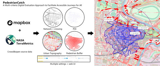
4. A Multi-Criteria Digital Evaluation Approach
4.1. Tool Development Aims
The discussion above indicates that there is an increasing need to improve pedestrian accessibility for the health of the whole population, especially older individuals, and to deepen our knowledge of accessibility for those with mobility limitations. New evaluation and pedestrian modelling tools are required to solve the aforementioned challenges and problems.
The novel approach and techniques discussed in this article intend to provide a tool that meets five criteria:
- User-friendly and inclusive
To develop an open-access, user-friendly interactive web-based application that overcomes the expense and steep learning curves associated with many of the aforementioned pedestrian modelling systems.
- Modelling dynamic catchments (spatio-temporal)
Combine the benefits of pedestrian access mapping with other dynamic factors within precinct catchment regions, such as varying wait times at crossing locations and depicting pedestrian flow over time.
- Designed for those with mobility disabilities (speeds and gradients)
Allow individuals with mobility impairments, disability communities, and urban planners to model and comprehend accessibility in their neighbourhood, while also offering tools for designing and advocating for more accessible urban programmes. The tool must be capable of accounting for differences in walking speeds across individuals with varying degrees of mobility and assessing slopes to identify topographical obstacles for those with mobility limitations.
- Flexible in terms of data input and approximation (including missing footpath data)
Being able make use of government network data sets from sources such as AURIN, as well as open sources for non-academic users and people from other regions of the globe. Where local expertise might help enhance the quality of the data, the tool per se should be able to utilise an editable and repairable data source (crowd-sourced). Due to the fact that many cities lack footpath data, the tool should also be capable of simulating pathways in the absence of accessible data while using existing data.
- Suitable for iterative scenario testing throughout design
To be able to rapidly test what-if scenarios for both greyfield and greenfield sites to enable researchers, planners, and urban designers to modify neighbourhood walkability to improve access to points of interest and generate comparable metrics for decision-making progress.
4.2. Tool Development and Multi-Criteria Digital Evaluation Approach
To accomplish these goals, we developed PedestrianCatch (
www.PedestrianCatch.com, accessed on 10 July 2022), an online accessibility mapping tool that simulates urban pedestrian catchments focusing on walkability for mobility-challenged individuals [
46,
47,
48]. Pedestrian access is calculated in the tool using large numbers of intelligent agents to measure the pedestrian catchments for a central node (start marker). The agents make basic decisions in moving away from the central node (e.g., a school), at walking speed, interacting with the streets, traffic, and crossings, measuring and mapping all the possible journeys that can be walked in a specified time (e.g., 10 min). The analysis, an animated isochrone with a catchment area analytics output, is suitable for comparative scenario studies and for stakeholder engagement as it highlights pedestrian access barriers and allows users to propose and rapidly test design options or interventions.
4.2.1. Executing the PedestrianCatch Scenario
The PedestrianCatch interface simplifies the process of modelling catchments by providing live, animated feedback. PedestrianCatch is developed in JavaScript as a browser-based client that queries an Enterprise JavaBeans webserver for scenario solutions. The normal, behind-the-scenes action happens when a scenario starts with requesting the OSM (OpenStreetMap) geo-referenced road network street segments or ‘ways’ for a chosen area. These paths are processed upon return and are transformed into discrete modelling segments. The server is in charge of creating a geo-referenced graph of path segments and modelling pedestrian agents on top of it. Each agent in the simulation is responsible for selecting which paths it should take and verifying whether a path has previously been travelled, while keeping track of its limitations, such as time. The user interface has been designed to be as simple and intuitive as possible without sacrificing essential functionality. When users first visit the website, they are welcomed with straightforward instructions and a Google Maps satellite background (
Figure 1). The user then picks a place for a scenario by entering a specific site name in the search box or navigating to a point on the map and then right-clicking. A gold-coloured node ‘start’ place marker is presented at a central default point on the route network, and the pedestrian ways around the specified site are automatically requested, downloaded, and displayed.
Following that, the start marker may be moved to a specific point of interest on the street network (e.g., a train station). After entering the maximum duration time in minutes, for example, 5 or 10 min, the scenario can be executed by pressing the ‘Start’ button. The programme then radiates out virtual pedestrian agents or “walkers” from the specified start point, travelling at a default speed of 1.33 m/s. The walkers are animated as they explore each conceivable route from the starting point to the furthest destination they can reach, leaving clickable ‘breadcrumbs’ in their footpaths. When these ‘breadcrumbs’ are clicked, the elapsed time and distance to that location are shown.
4.2.2. Visualisation and Result Analysis
Convex hull isochrones or network buffers (based on a selected simulation mode) are displayed at every two-minute interval during the animated simulation. These visualisation layers may be clicked to check the amount of time elapsed and the area covered. At the end of the scenario animation, a final isochrone or buffer zone is inserted at the appropriate termination time interval. Again, this isochrone or buffer area may be queried to get the time and total area or “catchment” region for the selected destination (
Figure 2). A maximum theoretical as-the-crow-flies Euclidean buffer circle is also added, centred on the start point with a radius based on distance (without taking into account the real way network) for the selected speed. It may be clicked to see the distance and area to allow the catchment efficiency or Pedestrian Catchment Area Ratio calculation, as defined by Schlossberg [
46].
As found in the previous study by White and Badland [
45,
47,
48], an essential feature of accessibility modelling that is not presently incorporated in other modelling methodologies is the traffic light cycle’s impact on the time taken to cross major roads and streets. This functionality was implemented in PedestrianCatch in two ways. First, crossing ways may be explicitly stated in a GeoJSON network dataset file which can be imported into PedestrianCatch with a specific wait time. Second, PedestrianCatch may automatically offset the way of the centrelines of the main highways to construct footpaths on each side, omitting the original centreline and substituting an interpolated crossing with a default wait time of 30 s (
Figure 3).
Based on previous work by White and Badland et al. [
45] and feedback from the industry stakeholders, it was clear that visualising pedestrian movement is a key component for understanding accessibility modelling, especially for non-experts. The scenario testing conducted by PedestrianCatch is depicted with animated pedestrian locations which mimic the walking movement over time (
Figure 4). The animated 2-min convex hull isochrones or buffer zones further help to explain the final resulting catchment (accessible) area.
The results of the requested scenarios present various analyses that are displayed to the user. The tool creates a variety of interrogatable points and shapes. Each of the ‘breadcrumbs’ left by a walker may be clicked to see the distance from the starting location and the time taken to get to that point. Each convex hull polygon or buffer zone may be pressed to check out the exact time consumption and total area.
The data generated may also be exported by clicking the export buttons. The scenario can be exported as a KML file (Keyhole Markup Language), an XML-based file format for displaying geographic data in an Earth browser such as Google Earth or Google Maps. The data from the road network may also be stored as a GeoJSON file.
4.2.3. Towards an Inclusive Community: Designing for People with Mobility Impairments
To address mobility issues for older adults and people with mobility impairments, the tool was designed with a graphical user interface that contains a slider with multiple preset speed values, ranging between 0.5 m/s to 10 m/s. This flexibility means that a user can test scenarios using a “typical” walking speed (1.33 m/s is used in the old style Euclidean buffers), speeds based on research on average speeds of a particular demographic, assisted/unassisted wheelchair speeds, or even cyclist speeds. Individuals can also use their own typical walking speeds based on data captured by pedometer/health smartphone applications such as Google Fit™, Samsung’s S Health™, or Apple Health™.
To account for topographic obstacles, PedestrianCatch calculates estimated slopes using open-source elevation data in combination with OSM data. To facilitate this computation, desired OSM paths are divided into straight-line segments of a maximum of 20 m. The elevation data for each of these paths’ endpoints is then obtained to calculate the gradient (increase over run) for the whole network. This gradient is then stored as a variable within the way and displayed on-screen as a colour range from flat as white to an increasing gradient as increasingly red-hued.
The steepest gradient that walkers may traverse can then be specified in the graphical user interface, allowing for the modelling of mobility-impaired accessibility. The gradient may be set as a ratio (for example, 1:14) or as an angle (for example, 5.25°) (
Figure 5 and
Figure 6). Road segments that surpass the prescribed gradient are highlighted in bright red with a thicker line style and are removed from the visualised scenario since they are impassible to walkers.
A catchment scenario can then be run with the chosen walker speed and topographic gradient threshold. A simulation is executed to determine the maximum distance convex hull or network buffers with the given walking speed for the specified duration. The convex hull is comparable to a secondary ‘maximum’ convex hull that considers the route network, but ignores slopes and crossing delays. A similar technique applies to the network buffer mode too. These polygons and buffers may be clicked to provide additional information such as time, distance, and area for the user (
Figure 7).
4.2.4. Testing What-If Scenarios
If users desire to test their own customised route network, they may simply drag and drop their own customised GeoJSON file into PedestrianCatch. This enables urban planners to examine the current urban fabric of a grey field site for accessibility and impediments, but also to propose and test the effect of prospective urban interventions.
Likewise, a planner or urban designer may be involved in the design of a new urban development on a greenfield site, and PedestrianCatch can be implemented to evaluate multiple design options, providing clients and community members with visual feedback on each option’s accessibility as well as metrics suitable for numeric comparative analysis.
It should be noted that OSM maps must not be edited to test what-if scenarios as this would corrupt the integrity of the OSM dataset.
5. Case Studies in Beijing and Melbourne
To test the applicability of this technology, we applied the PedestrianCatch tool and the proposed digital evaluation approach in two different urban contexts where accessibility for ageing and disability populations are seriously challenged: Beijing, the biggest city in north China and one of the most populous cities around the globe, is experiencing critical mobility problems due to a lack of barrier-free facilities and the wide existence of impermeable gated communities; Melbourne, ranked as one of the most liveable cities of the world, also suffers from compromised walking infrastructure arrangements in suburban locations due to entrenched car-dependent development patterns and the location of the majority of open space on the sloping banks of waterways. Despite the differences in these urban contexts, both cities have seen severe challenges for people with mobility impairment, older adults, and children in terms of access to essential services (open space) due to topographic conditions. Common scenarios, such as parents pushing prams, children riding bikes, or grandparents walking grandchildren to school, are all negatively impacted by long walking distances or steep gradients. Urban designers have a growing need for tools and appropriate accessibility modelling approaches that allow the assessment of street networks and gradients, and a need to identify both distance and topographical barriers to the design of inclusive urban environments for their communities, too.
5.1. Accessibility Evaluation in JiuLongHuaYuan, Chaoyang, Beijing
As one of the pilot cities for China’s fast urbanisation, gated communities have grown rapidly in the Beijing metropolitan region in the past few decades. Until February 2020, there were roughly 10,300 privately secured gated communities [
49]. Based on theories from community openness evaluations, current gated compounds in the Beijing urban area may be classed into four categories on a continuum from closed to open: an enclosed or fully-gated community, a semi-enclosed community, a semi-open community, and an open community [
50]. From the 1950s to the 1990s, enclosed communities with guarded gates and fences were widely built. These communities’ block edges are relatively long, ranging from 60 to 400 m; however, the number of gates on each side of the block is frequently limited to one or two [
51], and accessibility issues for specific demographics are often overlooked, posing a significant barrier to facilitate the inclusive walking community. Compared to the enclosed community, the other three types have smaller blocks with more gates and higher openness, yet still lack essential pedestrian infrastructures for the older adults and people who have mobility impairments.
The JiuLong HuaYuan neighbourhood is located at the very core of the Beijing CBD precinct and is considered one of the largest residential blocks in the surrounding area. The whole compound is primarily residential, accommodating 2333 households in total, and contains other building types such as office buildings and commercial buildings. As a typical gated community, JiuLong HuaYuan has relatively low permeability that inhibits pedestrian through-travel to both internal and external public facilities. The longest block side is around 400 m with merely five main gates in its perimeter. The road has a steep slope near the south entrance.
To thoroughly investigate the site and test the potential applicable renewal scheme, a simulation was conducted using PedestrianCatch. The starting point is positioned near the southern garden, one of the most popular spots for local residents. The first scenario uses default settings with a 1.33 m/s agent travelling speed and does not consider the gradient (topography). This approach intends to evaluate the pure network arrangements and pedestrian connectivity within 10 min. The result indicates that the total pedestrian accessible area is 1046,236 m
2 at 10 min and 319,264 m
2 for 6 min using the convex hull method. The visualised catchment also reveals that the access to the southwestern area is relatively limited, and the eastern regions are more reachable than the west pre-six minutes due to the position of the gates and the overall sidewalk layout (
Figure 8).
When taking urban topography into account, the trend is amplified. The convex hull again expands eastward as the steep infrastructure (coloured in red) severely undermines the overall accessibility (
Figure 9). By also lowering the walking speed to 0.80 m/s (the typical average speed for older adults and people with light mobility impairment), we can also observe a significant drop in the pedestrian accessible area to 327,915 m
2 at 10 min and 107,065 m
2 at 6 min (
Figure 10), indicating that the current permeability level is poor, preventing through-travel and making adjacent amenities exclusive for many local populations.
Essential infrastructure renewal and ‘ungating’ strategies can be used to mitigate this pressing concern. Although fully opened community development is often perceived as an ideal conceptual agenda in China regarding privacy, security concerns, and densified urban patterns, Beijing’s Jianwai SOHO neighbourhood is considered a relatively successful attempt at “ungating”. Designed by Riken Yamamoto and Field Shop, the superblock was split into nine smaller groups, and arterial roads and subsidiary streets were introduced to the site. The mixed road system and compound building type offer more mobility options that contribute to the community’s high level of vitality [
52,
53,
54]. While the full ungating approach applied in Jianwai SOHO cannot be implemented in every compound, this study argues that maximising openness and bringing in more accessible infrastructure would be greatly beneficial for a broader community. To test a similar/modified strategy applied at Jianwai SOHO and other open communities, we set up a new simulation scenario using revised road networks by connecting internal footpaths, extending cul-de-sacs, and setting new entrances and barrier-free infrastructure. The simulation result shows that the walkable area reaches 1,146,553 m
2 at 10 min and 364,517 m
2 at 6 min (
Figure 11), where the overall accessible areas are increased by 9.5% and 14% compared with the existing scenario (
Figure 8), and 56% and 91% when considering the gradient (
Figure 9).
5.2. Accessibility Evaluation in Footscray East, Maribyrnong, Melbourne
The City of Maribyrnong is a small, highly populated precinct on the banks of the Maribyrnong River in Melbourne’s inner west. With 40% of residents born outside of Australia, the city has the second most ethnically varied demographics in Victoria [
55]. The reorganisation of local manufacturing businesses and the removal of Commonwealth defence facilities from the region have resulted in changes in land use from industrial to mixed-use residential/business.
Unlike Beijing, the gated community strategy is rarely seen in the Melbourne urbanisation process. The proposed case study site is a typical block neighbourhood located at Footscray East, bounded by Footscray Park and Newell’s Paddock Urban Nature Park from the north and east (
Figure 12). In Footscray, population growth and ageing demographics combined with the conversion of industrial property to residential areas will put growing challenges on the precinct’s pedestrian infrastructure during the next few decades (
Figure 13). These two parks serve as essential leisure walking infrastructure and open public spaces that the local residents frequently visit. However, due to the undulating topography and limited pedestrian paths, free access to these areas is still challenging for people with mobility impairment.
In this scenario, we set the simulation ‘starter’ at the crossing of Lynch St and Moore St, which is the approximate centroid point of this block neighbourhood. Due to the topography, major pedestrian obstacles can be found near the primary entrance on Ballarat road. Ramps and the primary walking route within the two parks, Footscray and Newels Paddock, are also overly steep. The total walking coverage area is 823,023 m
2 at 10 min, with an ideal walking pattern on the west and south, given the permeable network layout in the residential neighbourhood, leaving most of the landscape and waterfront public spaces in both the north and east directions inaccessible (
Figure 14). To advocate the inclusive development scheme that accommodates the need for quality pedestrian infrastructure for all, we proposed a new scenario test by introducing new internal routes and ramps winding their way up to Ballarat road. The original network data were downloaded in GeoJSON format and edited on GIS platforms (
Figure 15). The result shows the walkable area hits 1,075,575 m
2 at 10 min with a 31% improvement compared to the previous scenario (
Figure 16). Most of the open public spaces along the river can be visited, even considering the speed declination of the people with impaired mobility (
Figure 17).
Through these two case studies, we could argue that the PedestrianCatch tool and proposed multi-criteria digital evaluation approach can be applied to test both existing and what-if scenarios under different urban contexts. This digital evaluation approach with a user-friendly simulation procedure can positively contribute to both pre-design and design processes, assisting urban designers, government officials, and local residents to better identify local accessibility challenges and test multiple design solutions.
6. Conclusions and Discussion
This paper has proposed a multi-criteria digital evaluation approach using the PedestrianCatch tool to facilitate accessible journeys delivering a more inclusive city. Responding to the pressing global need to increase city accessibility for health, ageing populations, and disability inclusiveness, this study develops an urgently needed walk-quality-focused online simulation tool for local governments, built environment professionals, and researchers to make more informed, integrated, and effective planning policy decisions. The online mapping tool can be applied in any urban context and enables the integration of data relating to the road network of specific local scenarios. The tool and the evaluation approach could also facilitate more informed understanding and participation in planning processes for the broader community.
The PedestrianCatch tool has proven effective and flexible, providing a platform for a diverse group of stakeholders to test a variety of urban scenarios for promoting an inclusive neighbourhood, in this case, parks and gated communities; however, it could also be applied to scenarios seeking to select the optimal location of new amenities, aged care facilities, housing for disability communities or medical facilities, and impacts of potential urban interventions to increasing catchments. As the walkable proximity to services or points of interest is a key factor in encouraging an inclusive and active community, PedestrianCatch provides a user-friendly tool for assessing accessibility that can be used particularly for improving life quality for older adults and people with mobility impairments. The unique use of animated agents as indicative walkers to visualise the pedestrian catchment is one of its key strengths as an urban design advocacy tool for a wide-ranging audience.
The ability to import network data in the GeoJSON format allows urban designers and planners to test what-if scenarios for future urban renewal schemes, from new pedestrian linkages and bridges, to highway downgrades and the lowering or raising of railway lines. The proposed evaluation approach may also be used to compare alternative street layout choices for future projects. This flexible procedure, coupled with freely-available crowd-sourced data in an online platform, enables tailor-made site-specific analysis to inform the re-design and adaption of urban infrastructures.
The two case studies in China and Australia demonstrate the feasibility and flexibility of the proposed evaluation approach for adapting radically different urban fabrics and conditions. In the Australian case study, mobility-compliant ramps added distances to pedestrian routes, but resolved the primary challenge of steep topography by making most of the waterfront all-age and ability accessible. Similarly, the ungating method applied in the Beijing case study may represent an additional civic expense and potentially cause more unpredicted security problems, however, the benefits gained from enhancing accessibility and permeability would arguably contribute not only to people with impairment, but also to wider populations with more significant social capital considering the emerging traffic and energy concerns.
Although the PededestrianCatch tool has proven useful in urban design research and practice (with over 20,000 uses worldwide), the tool is currently limited to the number of network accessibility factors. The tool does, however, provide an extensible platform to build upon and allow the integration of other crucial physical factors impeding active journeys, such as safety risks, air quality, and human thermal comfort in our future development. There is also a potential for PedestrianCatch to be developed as a smartphone app for both IOS or Android so it can be used by an even broader public user group. A smart-device version of the application suitable for tablets could be used in the field or on tablets in a community consultation environment.
The elevation data used for PedestrianCatch’s topographic analysis is currently too course to pick up detailed mobility barriers such as missing curb cuts, poorly maintained footpaths, or microscaled changes in grade or single steps. In future, it may be possible to add detailed survey data or fine-grain LiDAR topographic data for specific study areas. The tool’s interface could also potentially be further refined to be more inclusive for people with visual impairment through the development of an Accessibility Mode to allow for users of assistive technology, such as speech recognition software and screen readers.
In conclusion, the findings of this research are immediately significant to the urban planning and urban design community, as well as health planners and the disability community, and will become more relevant to the general public as the population ages. Our digital evaluation approach demonstrates how it may help to create more walkable and accessible communities for everyone and further contribute to the development of a more equal, healthy, and inclusive city.
Author Contributions
Conceptualisation, M.W. and X.H.; methodology, M.W. and X.H.; software, M.W. and X.H.; validation, X.H.; formal analysis, X.H.; investigation, X.H.; resources, M.W. and X.H.; data curation, X.H.; writing—original draft preparation, M.W. and X.H.; writing—review and editing, M.W. and N.L.; visualisation, X.H.; supervision, M.W.; project administration, X.H., M.W. and N.L.; and funding acquisition, X.H., M.W. and N.L. All authors have read and agreed to the published version of the manuscript.
Funding
This project is funded by the Australian Research Council Linkage Project [LP190100089], National key R&D programme “Science and Technology Winter Olympics” key project “Evacuation system and support technology for assisting physically challenged communities” [2020YFF0304900], the Beijing High-level Overseas Talents Support Funding, R&D Programme of Beijing Municipal Education Commission (KM202210009008), the NCUT Young Scholar Development Project, and The University Innovation and Entrepreneurship Training Programme [108051360022XN353] [108051360022XN370].
Data Availability Statement
All scenario tests conducted in this research can be reproduced along with accessible data on
www.pedestriancatch.com (accessed on 10 July 2022).
Acknowledgments
This research has built on prior work funded by the Australian Urban Research Infrastructure Network (AURIN) and The Australian National Data Service (ANDS). Preliminary research has been published in White M., Kimm G. PedCatch—inclusive pedestrian accessibility modelling using animated service area simulation with crowd-sourced network data. In: Healthy Future Cities. Beijing: China Architecture and Building Press; 2018. pp.190–202. We also appreciate Goeff Kimm and Tianyi Yang for their great contribution in developing and maintaining
www.pedestriancatch.com (accessed on 10 July 2022).
Conflicts of Interest
The authors declare no conflict of interest.
References
- United Nations. Ageing. Available online: https://www.un.org/en/global-issues/ageing (accessed on 10 July 2022).
- Taylor, M.; Buys, L. Ageing in Suburbia: Designing for Demographic Change in Australia and New Zealand. Archit. Des. 2014, 84, 54–59. [Google Scholar] [CrossRef]
- Inclusive Cities. Available online: https://www.worldbank.org/en/topic/inclusive-cities (accessed on 10 July 2022).
- Cities—United Nations Sustainable Development Action 2015. Available online: https://www.un.org/sustainabledevelopment/cities/ (accessed on 10 July 2022).
- Liang, D.; De Jong, M.; Schraven, D.; Wang, L. Mapping Key Features and Dimensions of the Inclusive City: A Systematic Bibliometric Analysis and Literature Study. Int. J. Sustain. Dev. World Ecol. 2022, 29, 60–79. [Google Scholar] [CrossRef]
- Liu, Z.; de Jong, M.; Li, F.; Brand, N.; Hertogh, M.; Dong, L. Towards Developing a New Model for Inclusive Cities in China—The Case of Xiong’an New Area. Sustainability 2020, 12, 6195. [Google Scholar] [CrossRef]
- Varma, S.; Gill, H. Development Strategies for Inclusive Cities. In Organizing and Managing in the Era of Globalization; SAGE: Thousand Oaks, CA, USA, 2010; pp. 368–387. [Google Scholar] [CrossRef]
- Dahiya, B.; Das, A. New Urban Agenda in Asia-Pacific: Governance for Sustainable and Inclusive Cities. In New Urban Agenda in Asia-Pacific; Springer: Berlin/Heidelberg, Germany, 2020; pp. 3–36. [Google Scholar]
- Rosso, A.L.; Auchincloss, A.H.; Michael, Y.L. The Urban Built Environment and Mobility in Older Adults: A Comprehensive Review. J. Aging Res. 2011, 2011, 816106. [Google Scholar] [CrossRef]
- Giles-Corti, B.; Wood, G.; Pikora, T.; Learnihan, V.; Bulsara, M.; Van Niel, K.; Timperio, A.; McCormack, G.; Villanueva, K. School Site and the Potential to Walk to School: The Impact of Street Connectivity and Traffic Exposure in School Neighborhoods. Health Place 2011, 17, 545–550. [Google Scholar] [CrossRef] [PubMed]
- Craig, L. Does Father Care Mean Fathers Share? A Comparison of How Mothers and Fathers in Intact Families Spend Time with Children. Gend. Soc. 2006, 20, 259–281. [Google Scholar] [CrossRef]
- WHO. Global Recommendations on Physical Activity for Health; World Health Organization: Geneva, Switzerland, 2010. [Google Scholar]
- Andersen, J.; Landex, A. GIS-Based Approaches to Catchment Area Analyses of Mass Transit. In Proceedings of the ESRI Users Group Conference, San Diego, CA, USA, 13–17 July 2009; ESRI: Redlands, CA, USA, 2009; pp. 1–13. [Google Scholar]
- Rodríguez, D.A.; Khattak, A.J.; Evenson, K.R. Can New Urbanism Encourage Physical Activity? Comparing a New Urbanist Neighborhood with Conventional Suburbs. J. Am. Plan. Assoc. 2006, 72, 43–54. [Google Scholar] [CrossRef]
- Beaglehole, R.; Bonita, R.; Horton, R.; Adams, C.; Alleyne, G.; Asaria, P.; Baugh, V.; Bekedam, H.; Billo, N.; Casswell, S.; et al. Priority Actions for the Non-Communicable Disease Crisis. Lancet 2012, 377, 1438–1447. [Google Scholar] [CrossRef]
- Colagiuri, S.; Lee, C.M.; Colagiuri, R.; Magliano, D.; Shaw, J.E.; Zimmet, P.Z.; Caterson, I.D. The Cost of Overweight and Obesity in Australia. Med. J. Aust. 2010, 192, 260–264. [Google Scholar] [CrossRef]
- Murray, C. Australia Leads on Key Health Measures. Available online: https://www.healthdata.org/news-release/australia-leads-key-health-measures (accessed on 10 July 2022).
- Litman, T. Transportation and Public Health. Annu. Rev. Public Health 2013, 34, 217–233. [Google Scholar] [CrossRef]
- Schlossberg, M.; Greene, J.; Phillips, P.P.; Johnson, B.; Parker, B. School Trips: Effects of Urban Form and Distance on Travel Mode. J. Am. Plan. Assoc. 2006, 72, 337–346. [Google Scholar] [CrossRef]
- Wang, H.; Zhai, F. Programme and Policy Options for Preventing Obesity in China. Obes. Rev. 2013, 14, 134–140. [Google Scholar] [CrossRef] [PubMed]
- Bell, A.C.; Ge, K.; Popkin, B.M. The Road to Obesity or the Path to Prevention: Motorized Transportation and Obesity in China. Obes. Res. 2002, 10, 277–283. [Google Scholar] [CrossRef] [PubMed]
- Alfonzo, M.; Guo, Z.; Lin, L.; Day, K. Walking, Obesity and Urban Design in Chinese Neighborhoods. Prev. Med. 2014, 69, 79–85. [Google Scholar] [CrossRef]
- Infrastructure Australia. State of Australian Cities 2012. Available online: https://www.infrastructureaustralia.gov.au/publications/state-australian-cities-2012 (accessed on 10 July 2022).
- Handy, S. Does the Built Environment Influence Physical Activity? Examining the Evidence. In Critical Assessment of the Literature of the Relationships Among Transportation, Land Use and Physical Activity; Transportation Research Board: Washington, DC, USA, 2005. [Google Scholar]
- Fox, K.R. At Least Five a Week: Evidence on the Impact of Physical Activity and Its Relationship to Health; HMSO: London, UK, 2004. [Google Scholar]
- Papas, M.A.; Alberg, A.J.; Ewing, R.; Helzlsouer, K.J.; Gary, T.L.; Klassen, A.C. The Built Environment and Obesity. Epidemiol. Rev. 2007, 29, 129–143. [Google Scholar] [CrossRef]
- Frumkin, H.; Frank, L.; Frank, L.D.; Jackson, R.J. Urban sprawl and public health: Designing, planning, and building for healthy communities; Island Press: Washington, DC, USA, 2004. [Google Scholar]
- Sugiyama, T.; Neuhaus, M.; Cole, R.; Giles-Corti, B.; Owen, N. Destination and Route Attributes Associated with Adults’ Walking: A Review. Med. Sci. Sports Exerc. 2012, 44, 1275–1286. [Google Scholar] [CrossRef]
- Feng, Z.; Liu, C.; Guan, X.; Mor, V. China’s Rapidly Aging Population Creates Policy Challenges in Shaping a Viable Long-Term Care System. Health Aff. 2012, 31, 2764–2773. [Google Scholar] [CrossRef]
- Centers for Disease Control and Prevention. Trends in Aging–United States and Worldwide. MMWR Morb. Mortal. Wkly. Rep. 2003, 52, 101–104. [Google Scholar]
- Liu, H.; Feng, Z.; Jiang, Q.; Feldman, M.W. Family Structure and Competing Demands from Aging Parents and Adult Children among Middle-Aged People in China. J. Fam. Issues 2020, 41, 235–261. [Google Scholar] [CrossRef]
- Hanibuchi, T.; Kawachi, I.; Nakaya, T.; Hirai, H.; Kondo, K. Neighborhood Built Environment and Physical Activity of Japanese Older Adults: Results from the Aichi Gerontological Evaluation Study (AGES). BMC Public Health 2011, 11, 657. [Google Scholar] [CrossRef]
- United Nations. Habitat III: Promoting Accessible and Inclusive Cities for All. Available online: https://www.un.org/en/desa/habitat-iii-promoting-accessible-and-inclusive-cities-all (accessed on 10 July 2022).
- United Nations. UN Convention on the Rights of Persons with Disabilities; United Nations: New York, NY, USA, 2006. [Google Scholar]
- Stuart, H. United Nations Convention on the Rights of Persons with Disabilities: A Roadmap for Change. Curr. Opin. Psychiatry 2012, 25, 365–369. [Google Scholar] [CrossRef] [PubMed]
- Kansky, K.J. Structure of Transportation Networks: Relationships Between Network Geometry and Regional Characteristics. Ph.D. Thesis, The University of Chicago, Chicago, IL, USA, 1963. [Google Scholar]
- Pushkarev, B.; Zupan, J.M. Urban Space for Pedestrians: A Report of the Regional Plan Association. C1975; MIT Press: Cambridge, MA, USA, 1975. [Google Scholar]
- Hillier, B. Space Is the Machine: A Configurational Theory of Architecture; Space Syntax: London, UK, 1996. [Google Scholar]
- Batty, M. Agent-Based Pedestrian Modeling. Environ. Plan. B Plan. Des. 2001, 28, 321–326. [Google Scholar] [CrossRef]
- Torrens, P.M. Cellular Automata and Multi-Agent Systems as Planning Support Tools. In Planning SUPPORT systems in Practice; Springer: Berlin/Heidelberg, Germany, 2003; pp. 205–222. [Google Scholar]
- Sevtsuk, A.; Mekonnen, M. Urban Network Analysis: A New Toolbox for Measuring City Form in Arcgis. In Proceedings of the 2012 Symposium on Simulation for Architecture and Urban Design, Orlando, FL, USA, 26–30 March 2012; Society for Computer Simulation International: Vista, CA, USA, 2012. [Google Scholar]
- Helbing, D. Agent-Based Simulations and Experiments to Study Emergent Social Behavior. In Social Self-Organization; Understanding Complex Systems; Springer: Berlin/Heidelberg, Germany, 2012; ISBN 978-3-642-24004-1. [Google Scholar]
- Sander, H.; Ghosh, D.; van Riper, D.; Manson, S. How Do You Measure Distance in Spatial Models? An Example Using Open-Space Valuation. Environ. Plan. B Plan. Des. 2010, 37, 874–894. [Google Scholar] [CrossRef]
- Hess, D.B. Walking to the Bus: Perceived versus Actual Walking Distance to Bus Stops for Older Adults. Transportation 2012, 39, 247–266. [Google Scholar] [CrossRef]
- Badland, H.; White, M.; MacAulay, G.; Eagleson, S.; Mavoa, S.; Pettit, C.; Giles-Corti, B. Using Simple Agent-Based Modeling to Inform and Enhance Neighborhood Walkability. Int. J. Health Geogr. 2013, 12, 58. [Google Scholar] [CrossRef]
- White, M. Densification, Pedestrian Catchments and the Battle for Middle Earth. Can Agent Based Pedestrian Modelling Be Used to Inform Urban Morphology? In Proceedings of the 51st IFHP 2007 World Congress, Future of Cities—Impacts—Indicators—Implementations, Copenhagen, Denmark, 23–26 September 2007; International Federation for Housing and Planning: Copenhagen, Denmark, 2007. [Google Scholar]
- White, M.; Kimm, G. PedCatch—Inclusive Pedestrian Accessibility Modelling Using Animated Service Area Simulation with Crowd Sourced Network Data. In Healthy Future Cities; China Architecture and Building Press: Beijing, China, 2018; pp. 190–202, 487–501. [Google Scholar]
- Schlossberg, M. From Tiger to Audit Instruments: Measuring Neighborhood Walkability with Street Data Based on Geographic Information Systems. Transp. Res. Rec. J. Transp. Res. Board 2006, 1, 48–56. [Google Scholar] [CrossRef]
- Xu, W.; Huang, X.; Kimm, G. Tear Down the Fences: Developing ABM Informed Design Strategies for Ungating Closed Residential Communities-Developing ABM Informed Design Strategies for Ungating Closed Residential Communities. In Proceedings of the 26th CAADRIA Conference, Hong Kong, 29 March–1 April 2021. [Google Scholar]
- Normile, D. China Rethinks Cities. Science 2016, 352, 916–918. [Google Scholar] [CrossRef]
- Sun, G.; Webster, C.; Chiaradia, A. Ungating the City: A Permeability Perspective. Urban Stud. 2017, 55, 2586–2602. [Google Scholar] [CrossRef]
- Rowe, P.G.; Kan, H.Y. Urban Intensities—Contemporary Housing Types and Territories; Birkhauser Verlag GmbH: Basel, Switzerland, 2014; ISBN 978-3-03821-477-9. [Google Scholar]
- Huang, X.; White, M.; Burry, M. A pedestrian-centric design strategy: Melding reactive scripting with multi-agent simulation. In Proceedings of the Symposium on Simulation for Architecture and Urban Design, Toronto, ON, Canada, 22–24 May 2017; pp. 309–316. [Google Scholar]
- Huang, X. A Computational Design Approach for Enhancing Precinct Walkability. Ph.D. Thesis, The University of Melbourne, Melbourne, VIC, Australia, 2019. [Google Scholar]
- Annual Report. Available online: https://www.maribyrnong.vic.gov.au/About-us/Our-plans-and-performance/Annual-report (accessed on 10 July 2022).
Figure 1.
Screen capture of PedestrianCatch greeting screen showing simple instructions with Google Maps background and graphic user interface.
Figure 1.
Screen capture of PedestrianCatch greeting screen showing simple instructions with Google Maps background and graphic user interface.
Figure 2.
Screen capture of PedestrianCatch example of simulation run on Ormond Station in Glen Eira, Victoria, Australia, using default settings in convex hull display mode.
Figure 2.
Screen capture of PedestrianCatch example of simulation run on Ormond Station in Glen Eira, Victoria, Australia, using default settings in convex hull display mode.
Figure 3.
Screen capture of PedestrianCatch displaying approximated ways offset to simulate footpaths and crossings around Myer, Melbourne.
Figure 3.
Screen capture of PedestrianCatch displaying approximated ways offset to simulate footpaths and crossings around Myer, Melbourne.
Figure 4.
Sequence of screen captures of Melbourne CBD PedestrianCatch simulation animation.
Figure 4.
Sequence of screen captures of Melbourne CBD PedestrianCatch simulation animation.
Figure 5.
Screen capture of PedestrianCatch displaying topographic analysis of gradients with maximum gradient set to 1:14. (red colour indicates inaccessible road segments).
Figure 5.
Screen capture of PedestrianCatch displaying topographic analysis of gradients with maximum gradient set to 1:14. (red colour indicates inaccessible road segments).
Figure 6.
Screen capture of PedestrianCatch displaying topographic analysis of gradients with maximum gradient set to 1:20. (red colour indicates inaccessible road segments).
Figure 6.
Screen capture of PedestrianCatch displaying topographic analysis of gradients with maximum gradient set to 1:20. (red colour indicates inaccessible road segments).
Figure 7.
Screen capture of PedestrianCatch showing catchment simulation for Melbourne CBD with accessible buffer zone reduced by the steep gradient.
Figure 7.
Screen capture of PedestrianCatch showing catchment simulation for Melbourne CBD with accessible buffer zone reduced by the steep gradient.
Figure 8.
Screen capture of PedestrianCatch showing catchment simulation for JiuLong HuaYuan neighbourhood with default settings.
Figure 8.
Screen capture of PedestrianCatch showing catchment simulation for JiuLong HuaYuan neighbourhood with default settings.
Figure 9.
Screen capture of PedestrianCatch showing catchment simulation for JiuLong HuaYuan neighbourhood with convex hull reduced by the steep gradient.
Figure 9.
Screen capture of PedestrianCatch showing catchment simulation for JiuLong HuaYuan neighbourhood with convex hull reduced by the steep gradient.
Figure 10.
Screen capture of PedestrianCatch showing catchment simulation for JiuLong HuaYuan neighbourhood with slowed speed setting for people with mobility impairment.
Figure 10.
Screen capture of PedestrianCatch showing catchment simulation for JiuLong HuaYuan neighbourhood with slowed speed setting for people with mobility impairment.
Figure 11.
Screen capture of PedestrianCatch showing catchment simulation for JiuLong HuaYuan neighbourhood with revised street network and barrier-free infrastructures.
Figure 11.
Screen capture of PedestrianCatch showing catchment simulation for JiuLong HuaYuan neighbourhood with revised street network and barrier-free infrastructures.
Figure 12.
Screen capture of PedestrianCatch showing the topography and footpath condition in East Footscray, Melbourne.
Figure 12.
Screen capture of PedestrianCatch showing the topography and footpath condition in East Footscray, Melbourne.
Figure 13.
A steep ramp spotted in Cranwell Garden, which is ubiquitous amongst Footscray, makes this place less accessible not only for wheelchair users and seniors, but also for cyclists and leisure walkers.
Figure 13.
A steep ramp spotted in Cranwell Garden, which is ubiquitous amongst Footscray, makes this place less accessible not only for wheelchair users and seniors, but also for cyclists and leisure walkers.
Figure 14.
Screen capture of PedestrianCatch showing catchment simulation for East Footscray neighbourhood with buffer zone reduced by the hilly topography around the gardens.
Figure 14.
Screen capture of PedestrianCatch showing catchment simulation for East Footscray neighbourhood with buffer zone reduced by the hilly topography around the gardens.
Figure 15.
Screen capture of QGIS showing how new zigzag footpaths can be easily added to the existing road network.
Figure 15.
Screen capture of QGIS showing how new zigzag footpaths can be easily added to the existing road network.
Figure 16.
Screen capture of PedestrianCatch showing catchment simulation for East Footscray neighbourhood with revised road networks.
Figure 16.
Screen capture of PedestrianCatch showing catchment simulation for East Footscray neighbourhood with revised road networks.
Figure 17.
PedestrianCatch catchment simulation for East Footscray neighbourhood with slowed speed setting for people with mobility impairment using revised road networks, providing intuitive visual feedback of how accessible area increased compared to the original condition.
Figure 17.
PedestrianCatch catchment simulation for East Footscray neighbourhood with slowed speed setting for people with mobility impairment using revised road networks, providing intuitive visual feedback of how accessible area increased compared to the original condition.
| Publisher’s Note: MDPI stays neutral with regard to jurisdictional claims in published maps and institutional affiliations. |
© 2022 by the authors. Licensee MDPI, Basel, Switzerland. This article is an open access article distributed under the terms and conditions of the Creative Commons Attribution (CC BY) license (https://creativecommons.org/licenses/by/4.0/).


