Article

A Study on Whether a ‘Maze’-like Layout Contributes to the Improvement of Wind Environments in Traditional Coastal Villages—A Validation Study Based on Numerical Simulation

1
School of Environment Science and Engineering, Tianjin University, Tianjin 300072, China
2
School of Architecture, Tianjin University, Tianjin 300072, China
3
School of Humanities and Arts, Hainan College of Economics and Business, Haikou 571127, China
*
Author to whom correspondence should be addressed.
Buildings 2024, 14(9), 2805; https://doi.org/10.3390/buildings14092805
Submission received: 29 July 2024 / Revised: 3 September 2024 / Accepted: 4 September 2024 / Published: 6 September 2024
(This article belongs to the Special Issue Ventilation and Air Quality in Buildings)

Abstract

:
The coastal regions of Fujian, characterized by a subtropical maritime monsoon climate, experience a high frequency of windy days throughout the year, which significantly impacts residents’ lives. Local traditional villages, through long-term practical exploration, have developed a unique “maze-like” spatial layout adapted to withstand harsh wind conditions. This study aims to quantitatively analyze the climatic adaptability advantages of this traditional layout, providing theoretical support for the protection of historical cultural heritage and guidance for modern village construction. The methodology includes field wind measurement for data acquisition, construction of current and regularized divergent models, and comparative numerical simulations under scenarios of strong winter winds and typhoons. The results indicate that wind speeds within traditional villages are generally lower. The layout’s nonlinear roads and clusters of buildings form multiple buffer zones that effectively reduce wind speeds. In contrast, areas in the divergent model experience excessively high wind speeds, impacting outdoor activity safety and comfort. The traditional “maze-like” layout encapsulates the climate adaptation wisdom of ancestors, enhancing wind environment regulation, thermal comfort, and disaster resilience. This layout concept merits promotion and innovative application in the new era to construct livable, green, and sustainable human environments.

1. Introduction

Understanding wind environments is crucial in building and urban design, as wind patterns significantly influence the comfort, safety, and sustainability of built environments. In coastal and wind-prone areas, the management of wind flow is particularly important to prevent structural damage, reduce heat loss or gain, and ensure human comfort. Traditional village layouts have been noted for their potential to enhance wind environments by influencing airflow patterns around buildings and public spaces. This study focuses on analyzing the impact of such traditional village layouts on wind environments through numerical simulations, aiming to validate their effectiveness in modern contexts.
Wind affects urban and rural settlements in multiple ways, influencing not only the microclimate and air quality but also the energy efficiency and structural stability of buildings. The effects of wind can be both beneficial and detrimental, depending on the design and orientation of the structures. For instance, strategic urban planning can leverage wind to improve ventilation and reduce pollution in dense cities, while poor planning can exacerbate wind-related issues, such as drafts, wind tunnels, and cold air pooling [1].
Historically, various strategies have been employed to mitigate wind effects, such as the use of windbreaks, strategic building placement, and specific architectural forms adapted to local wind conditions [2]. In coastal regions, where strong winds are more frequent, traditional settlements often feature narrow alleys and irregular layouts to reduce wind speed at ground level and protect structures from wind damage [3].
Building orientation and layout are key factors in wind mitigation, influencing how wind interacts with structures and open spaces. Several studies have highlighted the importance of aligning buildings and arranging them in a way that minimizes wind exposure and promotes ventilation [4]. For example, north–south orientations are often preferred in many regions to take advantage of prevailing winds for cooling while minimizing exposure to cold winds [5].
The relationship between architectural design and wind comfort has been extensively studied, showing that both the macro-scale layout of urban areas and the micro-scale design of individual buildings play a crucial role [6]. Urban morphology, building height, street width, and the orientation of buildings significantly affect wind flow and its impact on pedestrian comfort and building energy use [7].
Research on traditional layouts, particularly in coastal or wind-prone areas, has shown that specific patterns can be highly effective in managing wind flow [8,9]. Computational fluid dynamics (CFD) has been used to analyze the impacts of different layouts on wind environments. Multiple studies conducted in places like Lianjiang County in Fuzhou, China; southern Shaanxi, China; and Tsushima Island, Japan have found that residential layouts significantly influence wind environments. Staggered and dispersed layouts create a wind reduction effect, enhancing thermal comfort [10,11,12]. Studies have documented that traditional structures, characterized by irregular pathways and varied building heights, can reduce wind speed and turbulence, enhancing thermal comfort in both outdoor and indoor environments [13]. For example, the compact and complex street networks of Mediterranean villages have been found to moderate strong winds, providing more comfortable conditions for inhabitants [14].
Such studies suggest that traditional “maze-like” layouts might offer valuable insights for contemporary urban design, especially in regions facing similar climatic challenges. However, there is still a need for empirical data to confirm these findings and understand the underlying mechanisms through which these layouts affect wind flow [15].
While there is substantial literature on urban wind environments and traditional layouts, there is a notable gap in detailed studies on the effectiveness of traditional village layouts in modern contexts. Existing research primarily focuses on either historical analyses [16] or contemporary urban environments [17], with limited attention paid to how these layouts could be adapted or implemented in today’s urban planning [18]. This paper aims to fill these gaps by using numerical simulations to provide empirical data on the impact of “maze-like” village layouts on wind environments.
The primary objective of this study is to evaluate whether traditional “maze-like” layouts can be effectively applied in contemporary urban design to manage wind environments. This research hypothesizes that such layouts can reduce wind speeds at pedestrian levels and enhance thermal comfort, similar to their historical use in traditional coastal villages. Through numerical simulations and data analysis, the study seeks to validate these hypotheses and provide a framework for future urban planning practices.
The findings of this study could have significant implications for urban planning and architectural design, particularly in coastal and wind-prone regions. By understanding how traditional layouts can influence wind environments, urban planners and architects could develop more effective strategies to improve thermal comfort and reduce energy consumption in cities. Furthermore, this research could inform policy decisions and practical implementations in urban development, promoting sustainable and resilient design practices.

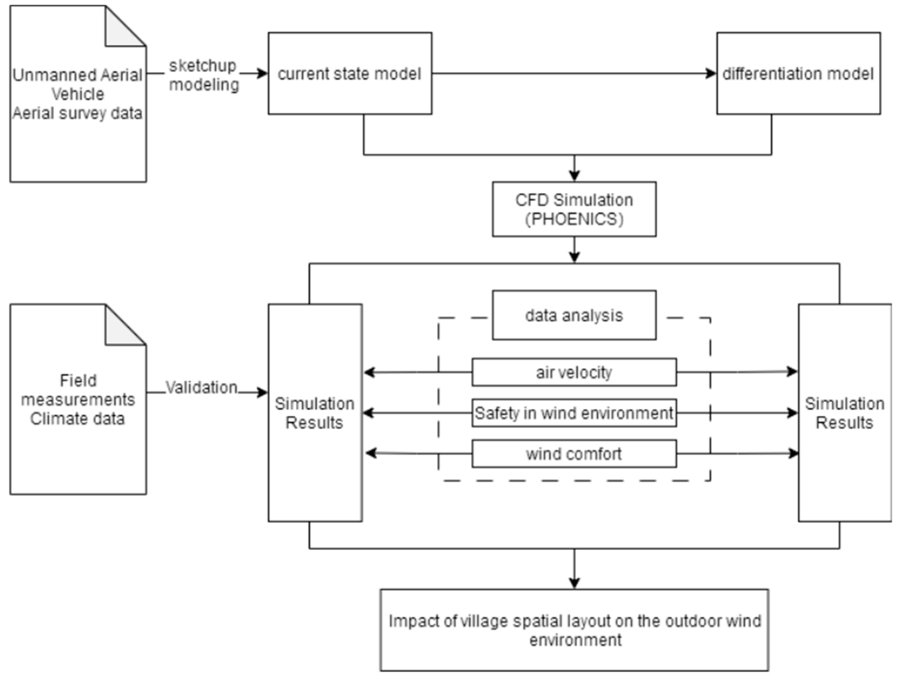
2. Materials and Methods

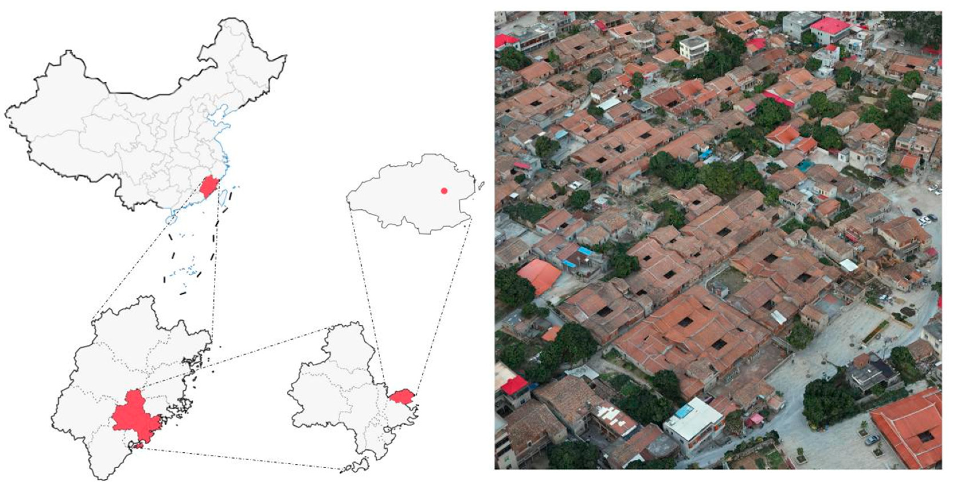
2.1. Objects of Study

Fujian Province, located in the eastern coastal region of China, is characterized by its numerous islands and plains, with a relatively flat terrain and low surface roughness, resulting in generally higher wind speeds by 2–4 m/s, compared to inland areas. Meteorological statistics indicate that Fujian is affected by 3–7 typhoons annually, with the typhoon season concentrated between July and September. The increasing frequency of severe typhoons poses significant threats to residential and architectural safety in the region. The traditional villages of Fujian are renowned for their unique spatial layouts and architectural features, reflecting the area’s rich cultural heritage and historical value. These village layouts often demonstrate a respect for nature and ecology, emphasizing the belief that humans are an inseparable part of nature [19]. The spatial distribution of traditional Fujian villages is cohesive, with a clear emphasis on aggregation [20].
In this study, Tukeng Village, located in the middle of Houlong Town, Quangang District, Quanzhou City, Fujian Province, was selected as the research object, and it is situated on the south coast of Meizhou Bay in the subtropical monsoon climate zone along the coast of Fujian Province, with four distinct seasons and abundant rainfall. Its history dates back to around the year 1404. In 2003, Tukeng Village was designated as a Fujian Provincial Historic and Cultural Village due to its well-preserved ancient residential buildings from the Ming and Qing dynasties, and it was listed as one of China’s Historic and Cultural Villages in the sixth batch in February 2014.
The traditional village of Tukeng is built with a compact architectural layout. Most residential buildings face southeast, with the predominant form being the southern Fujian-style courtyard houses constructed of wood, featuring two-entry three-bay and five-bay two-entry layouts, and built using red brick and granite materials. The spatial organization is clearly ordered, centered around ancestral halls and clan buildings, creating a hierarchical progression from the core to the periphery (Figure 1).
Due to the monsoon climate, significant wind-related environmental issues exist locally, with strong winds disrupting normal daily activities. The persistent windy conditions adversely affect residents’ mental health, directly impacting the ventilation and comfort of outdoor spaces [21,22,23,24], and are closely related to the spread of diseases and health issues [25,26,27]. Research has shown that differences in architectural layout and spatial arrangements can result in substantial variations in simulated and measured comfort assessments [28,29,30].
In response to these challenges, many traditional villages in the area have undertaken beneficial explorations and innovations in site selection and architectural layout, resulting in unique settlement forms. Through thousands of years of historical evolution, the residential settlements along the Fujian coast have developed architectural forms adapted to the climate, characterized by smaller openings in individual buildings and compact courtyard spaces. In terms of architectural layout, unlike the traditional Chinese settlements, which pursue a “regular and orderly” grid layout [31], most adopt a staggered, clustered grouping model. The streets are winding and feature “T”-shaped and “Y”-shaped intersections, presenting an “irregular” maze-like layout. This seemingly “disorderly” arrangement scientifically utilizes the arrangement of building clusters to mitigate wind effects, enhancing thermal comfort. It is an adaptation to the unique coastal wind conditions.
The research scope includes the village’s core area and its surrounding traditional architecture, particularly focusing on its typical “maze-like” structure. The objective is to explore the differences in the effects of traditional and regularized architectural layouts on the wind environment through CFD numerical simulation methods.

2.2. Research Methodology

2.2.1. CFD Simulation

Computational fluid dynamics (CFD) is a technique that employs numerical methods to solve the kinematic and physical equations of fluids, facilitating the simulation of systems involving fluid flow, heat transfer, and related phenomena. The fundamental principle of CFD software involves numerically approximating and solving a set of partial differential equations—such as the continuity equation, Navier–Stokes equations, and energy equation—on a discretized grid within the computational domain. This process includes steps such as preprocessing, iterative solving, and postprocessing to achieve numerical simulation and analysis of fluid issues [32].
Popular CFD softwares include ANSYS Fluent, PHOENICS, OpenFOAM, COMSOL Multiphysics, and Simcenter STAR-CCM+, each with distinctive features and extensively applied in fields such as aerospace, automotive, energy, and environmental engineering [33,34,35,36,37,38,39,40]. In the realm of building environments, CFD is utilized to simulate airflows both inside and outside buildings and to analyze indoor thermal comfort, providing optimization solutions for architectural design [40,41,42]. Overall, the CFD software provides a powerful simulation tool for architectural environment research, with its reliability extensively validated by numerous studies, making it fully suitable for research in building environments.

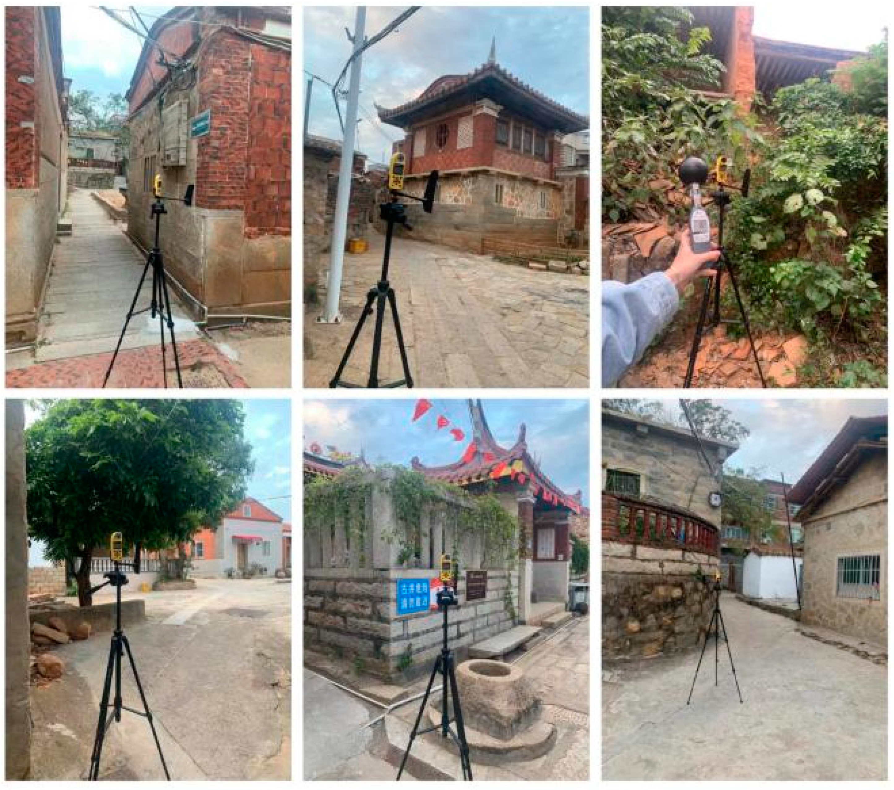
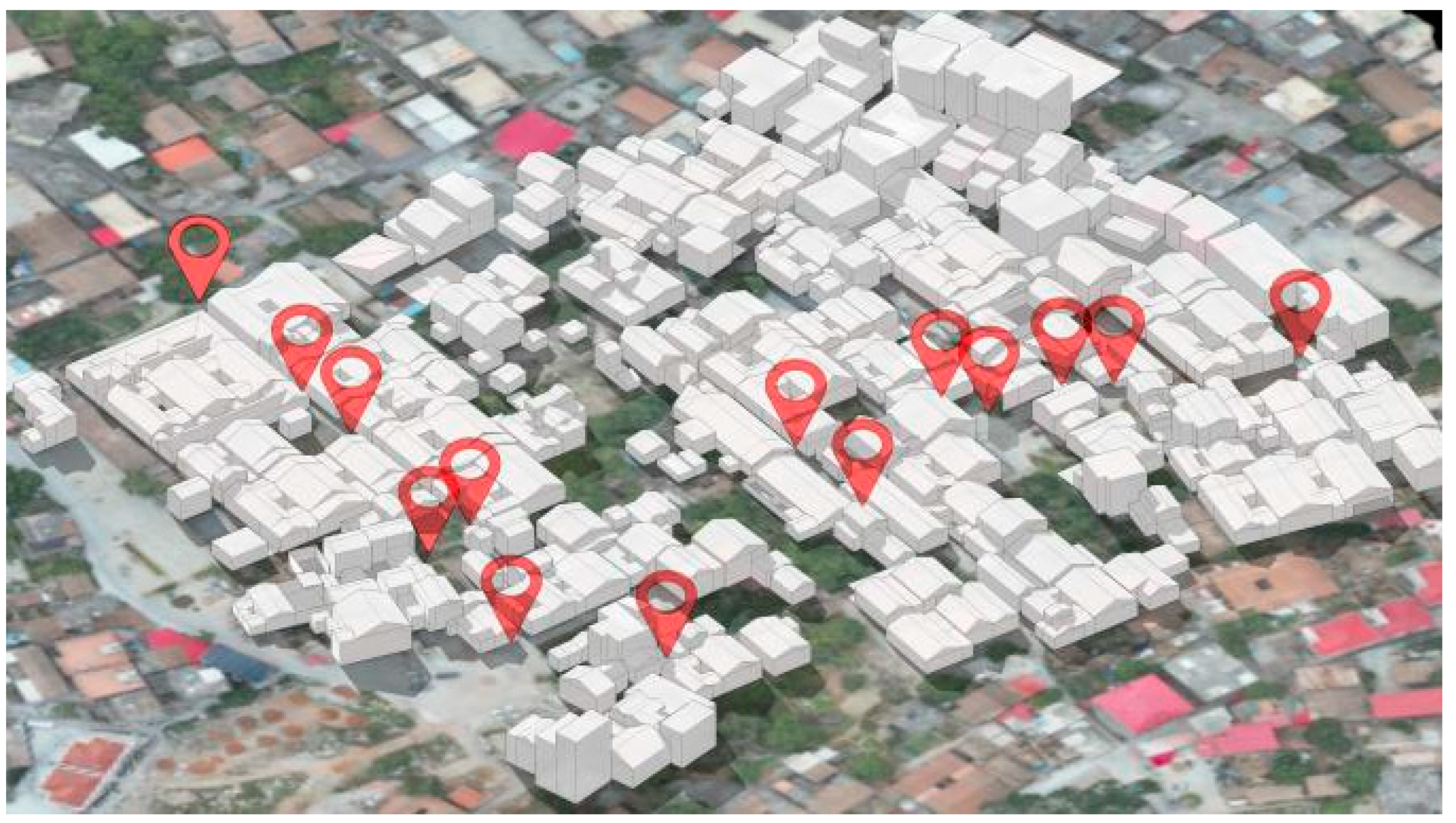
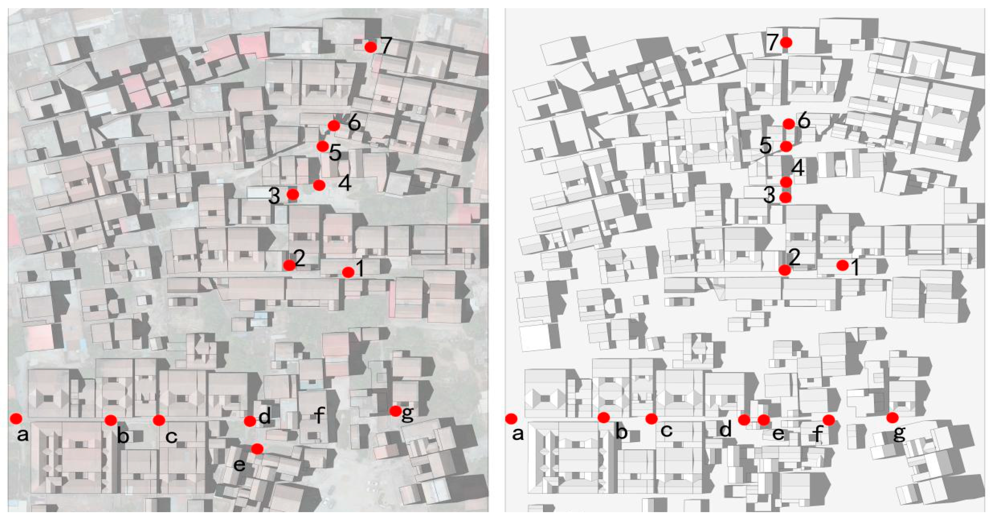
2.2.2. Field Measurements and Alienation Modeling
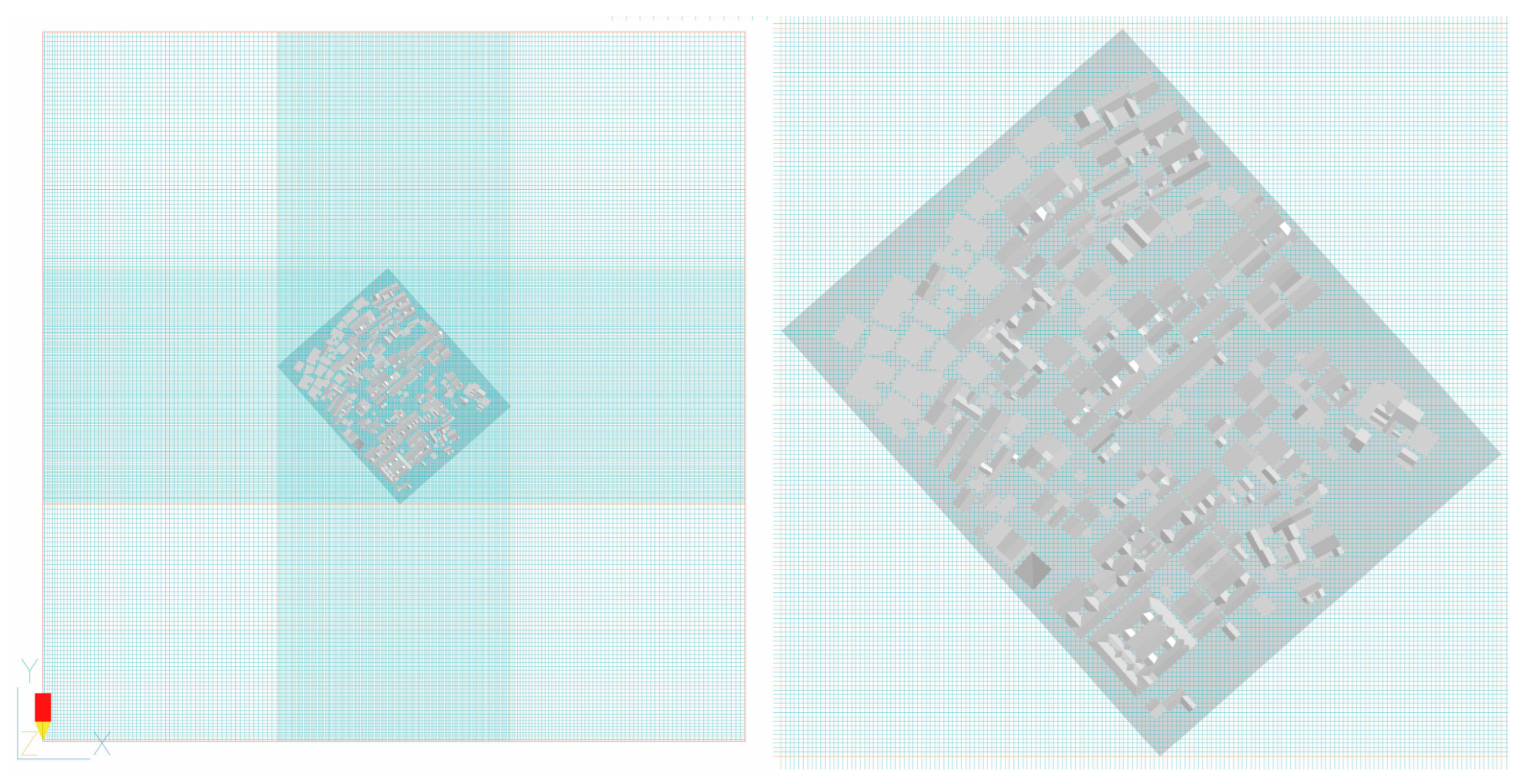
This study employed a combined approach of field monitoring and software simulation to investigate the impact of architectural layouts on site wind environments.
Multiple points at the target site were monitored using the Kestrel NK5500 handheld weather station, a device manufactured in the USA known for its precision in environmental monitoring. The NK5500 boasts an accuracy of ±0.3 m/s for wind speed measurements, ensuring high reliability in data collection. Data collection occurred daily from 09:00 to 17:00.
Due to the limited number of instruments, the mobile measurement mode was used. First, the instrument was left to stand for 5 min to ensure that it was in a stable condition. After that, six readings were taken at one-minute intervals at each measurement point, and the average value was taken as the measurement result of that point. One round of data collection was completed every hour, and nine rounds of sampling were repeated throughout the day in total. The instrument was operated in strict accordance with the relevant technical specifications and was placed at a height of 1.5 m from the ground, away from objects that might obscure the data to avoid affecting the data collection. All raw data were recorded on the spot and photographed for subsequent processing and analysis (Figure 2). The monitoring points were strategically arranged along two main roads that ran perpendicular and parallel to the primary orientation of the village buildings. The vertical points were numbered from 1 to 7, and the horizontal points were lettered from a to g. This arrangement was designed to comprehensively capture variations in wind speed caused by the distribution of buildings, thereby providing empirical support for evaluating the wind environment regulation effects of the “maze-like” architectural layout. The layout of the monitoring points considered the ventilation paths within the village and the gaps between buildings to ensure accurate recording of wind conditions.
In addition, the study utilized a DJI RTK350 drone for oblique aerial photography to generate a triangular mesh model for use as a reference in modeling. Based on the spatial data obtained, the site’s three-dimensional model was simplified and reconstructed using the SketchUp 2019 software (Figure 3). The model was then imported into PHOENICS for numerical simulation, and the results were compared with those from field monitoring to validate the reliability of the model and software settings.
In this study, we developed a “divergent model” by maintaining the original structures of individual buildings but reorganizing them into a more standardized order. Alienation modeling, a method used here, involves crafting a modified version of the existing spatial arrangement to evaluate the theoretical effects of changes in structure and layout. Specifically, this study reconfigured the traditional, irregular layout of a village into a more systematic pattern, enabling a comparative computational fluid dynamics (CFD) simulation of wind dynamics under both conventional and modified conditions. This approach provided valuable insights into how various architectural layouts influence the management of environmental forces, such as wind. The divergent model was created by transforming the traditional village’s nonlinear roads and layout into a regularized format. This was achieved by straightening the two main roads while keeping the original building positions intact, thereby enhancing wind circulation. This model served to assess the potential impacts on the overall wind environment resulting from modifications in road layouts without altering the building structures.
The data points in the divergent model corresponded to those of the field measurements, ensuring consistency and comparability in the data when comparing traditional and divergent models. This setup allowed for a direct comparison of wind environment differences between the two layouts under the same external wind conditions, thereby quantifying the specific impacts of architectural layout adjustments on wind speed and direction distribution within the village (Figure 4).
Subsequently, numerical simulations were carried out by importing the two models into the PHOENICS 2016 software and setting the same environmental boundary conditions. The results of the two simulations were compared to analyze the effects of the changes in building layout on the wind speed distribution and wind flow field at the site (Figure 5).

3. Simulation

3.1. Software Settings

In this study, the outdoor wind environments of different building layouts were analyzed by numerical simulation using the PHOENICS software. Using the RNGk-εturbulence model in the PHOENICS software, the simulation using Equations (1) and (2) are shown below:
( ρ k ) t + ( ρ k u i ) x i = x j ( α k η e f f k x j ) + G k + ρ ε
( ρ ε ) t + ( ρ ε ν i ) x i = x j ( α ε η Δ f ε x j ) + C 1 s * ε k G k C 2 s ρ ε 2 k
where the turbulent kinetic energy is denoted by k, and the turbulent dissipation rate is denoted by ε.
This study employed the PRESTO discretization scheme and the built-in PARSOL function to establish models for simulating velocity–pressure coupling. To enhance computational accuracy, a fine-scale mesh was used. The PHOENICS’ automatic convergence detection feature ensured a reasonable convergence of simulation results, with a convergence precision set at 10−5 [43].
After converting the existing village layout model and the regularized divergent model into the STL format, they were imported into PHOENICS. The simulation parameters were set based on the actual dimensions of the study area, with the height of the computational domain being three times that of the tallest building and the width being five times the planar dimensions (Figure 6).
Then, setting uniform environmental boundary conditions, numerical simulations were performed on the two layout models under two different operational conditions: winter and typhoon. For the winter condition, meteorological data from the Quanzhou area was used, drawing on the “Design Standard for Heating, Ventilation and Air Conditioning of Civil Buildings” (GB50736-2012, China), “China Weather Network”, “China Meteorological Network”, and “China Meteorological Data Network”. The average winter wind speed in Quanzhou was 6.13 m/s, with a prevailing wind direction from the northeast. The typhoon condition was based on data from the National Solar Radiation Database (NSRDB) recorded during Typhoon Meranti from 14–15 September 2016, using an east–northeast (ENE) wind direction with an initial wind speed set at 16.2 m/s, reflecting the average wind speed near the typhoon center. The iteration number for the inflow boundary conditions was set at 2000, with a ground roughness value of 0.2.

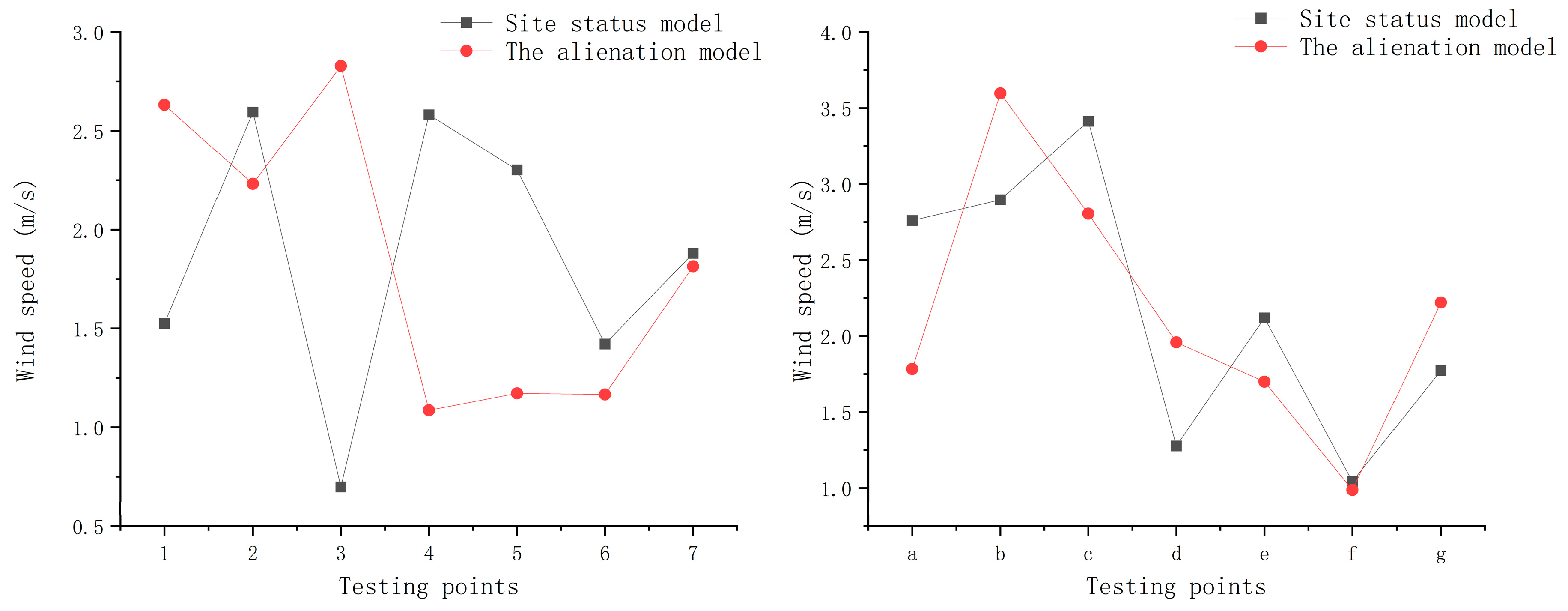
3.2. Reliability Verification of Simulation Results

An analysis of the field-measured data and simulation results revealed a high correlation between the two, as indicated by an R2 value of 0.8045. This indicates that the simulated wind speeds can explain 80.45% of the variance in observed wind speeds. Such a high R2 value indicates a strong linear relationship between the simulated and measured data, suggesting that the wind speeds simulated by PHOENICS closely match the actual field measurements. The linear regression equation was given by Y = 0.1422506X + 0.4078 (Table 1).
Furthermore, the p-value was less than 0.006, confirming that the linear regression analysis was statistically significant (Table 2). Additionally, the normal distribution of residuals, as shown in the histogram (as depicted in Figure 7b), indicated a good fit of the model. These results support the use of the PHOENICS model to simulate the wind environment in outdoor spaces and further validate the effectiveness of CFD simulation data in analyzing the spatial dynamics of traditional village squares.

4. Results

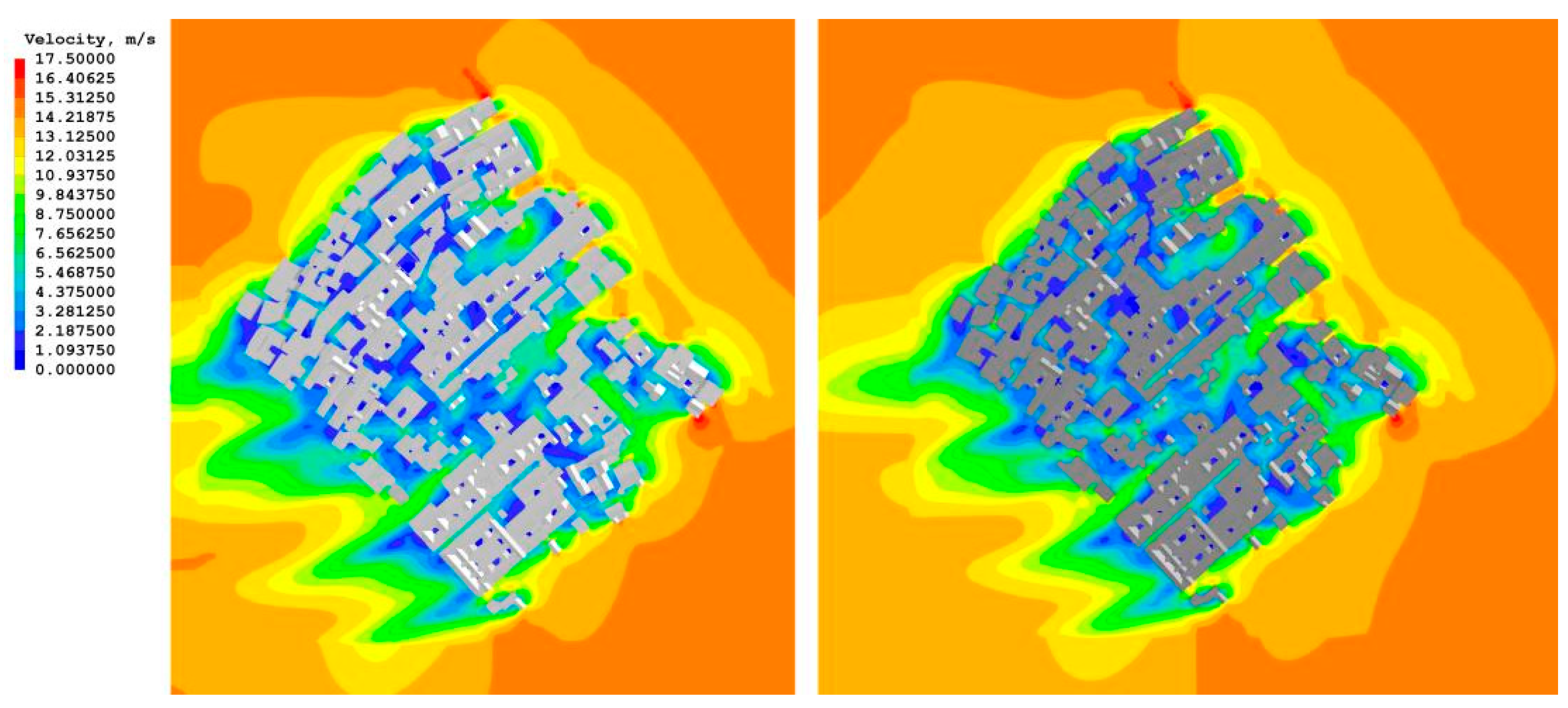
4.1. Differences in the Impacts of Different Village Patterns on the Wind Environment under Winter Conditions

In this study, climate statistics from the Quanzhou Meteorological Network were used to select the most common wind direction and average wind speed during winter as initial conditions for numerical simulations, given the village’s proximity to the sea and its frequent exposure to strong winds in the winter. Proper architectural layout is crucial for modulating wind speeds and enhancing the comfort of outdoor activities for residents.
When evaluating wind comfort, this study primarily adhered to the “Green Building Evaluation Standard” (GB/T 50378-2019), which specifies that the wind speed at 1.5 m above the ground in pedestrian areas around buildings should be less than 5 m per second [44].
Wind speed contours indicate that in the current model, most areas within the village experience low wind speeds, primarily ranging from 0.7 to 2.6 m/s, demonstrating that the layout effectively reduces wind speeds, creating a more comfortable outdoor environment. The nonlinear layout of buildings and roads plays a key role in naturally blocking and slowing down wind, especially in densely built areas. In contrast, the wind speed contours of the divergent model show significant increases in some open areas and along straightened roads, reaching 3.6 to 5.8 m/s, reflecting that spaces designed to enhance wind circulation under conditions of strong winter winds may instead reduce outdoor comfort and safety due to excessively high wind speeds (Figure 8).
By comparing wind speeds at the same numbered monitoring points under different layouts, further insights into the environmental differences between the two models were revealed. Internal monitoring points (1, 3, and 7) experienced significantly higher wind speeds in the divergent model, indicating that straightened roads enhanced air circulation in these areas. However, for points located within building clusters (4, 5, and 6), wind speeds actually decreased in the divergent model, likely due to the straightened road layout creating new wind barriers formed by the surrounding buildings, which impeded airflow. Additionally, significant increases in wind speeds at edge points (b and h) in the divergent model reflect the effect of unobstructed straight roads on accelerating wind speeds, which could lead to decreased comfort in the winter (Figure 9).
These differences primarily stem from changes in road and building layouts. The current model shows a greater advantage in maintaining winter wind comfort, highlighting the wisdom of traditional village layouts in adapting to specific geographical and climatic conditions. The nonlinear roads and irregular building arrangements effectively act as natural wind barriers, enhancing residents’ comfort through a diversified wind environment. In contrast, the divergent model, with its regularized road layouts to enhance air circulation, may result in excessively high wind speeds in the absence of sufficient natural or artificial wind barriers, which is detrimental to winter residential comfort. Therefore, the current model demonstrates a significant advantage in maintaining winter comfort, underscoring the traditional village layout’s adaptation to specific geographic and climatic conditions. Future village planning and design in the region should fully consider these factors to ensure that the improved environment promotes ventilation while maintaining necessary residential comfort.

4.2. Differences in the Impacts of Different Village Patterns on the Wind Environment under Typhoon Conditions

By analyzing wind speed contours and data from various monitoring points, the differences in typhoon resistance between the two layouts are revealed, and the reasons for these differences are further explored. In the wind speed contour of the current model, the village’s central area exhibits lower wind speeds, predominantly in shades of blue to green, generally below 3 m/s. This indicates that the nonlinear roads and compact building layout effectively reduce wind speeds. In contrast, the divergent model’s wind speed contour in the same central area shows higher wind speeds, transitioning from yellow to red, often exceeding 5 m/s. This significant difference clearly demonstrates that the straightened road layouts greatly accelerate wind flow. While this increases air circulation, it also raises risks under typhoon conditions, as the faster wind speeds can be more hazardous (Figure 10).
Specifically focusing on wind speeds at designated monitoring points, for example, at monitoring point 7, the wind speed in the current model was recorded at 2.46 m/s, whereas in the divergent model, it reached 6.33 m/s. This significant increase indicates that in traditional layouts, numerous obstacles and non-linear roads effectively reduce wind speed, enhancing risk prevention capabilities. Similarly, at monitoring point a, the wind speed in the current model was 5.99 m/s, increasing to 6.34 m/s in the divergent model. These data further confirm the impact of straightened roads on accelerating wind speeds (Figure 11).
The primary cause of these differences in wind speed is the contrasting road and building layouts between the two models. The current model utilizes non-linear roads and irregular building layouts to create multiple buffer zones, effectively dispersing wind speeds and mitigating direct impacts on buildings and residents. Although the divergent model simplifies the village’s spatial structure and increases wind speeds in certain areas, excessively high wind speeds during typhoons may pose safety risks, particularly for areas directly facing main roads.
Comprehensive analysis shows that traditional non-linear architectural and road layouts provide more effective wind protection measures in regions prone to typhoons. Compared to the divergent model, the current model offers significant advantages in enhancing the safety of residents’ outdoor activities. This layout serves as a natural wind barrier for the village, making it an ideal choice adapted to the region’s specific climatic conditions. Therefore, the protection and planning of traditional villages should consider this aspect to avoid overlooking the value of traditional wisdom during modernization efforts.

5. Discussion

This research has rigorously demonstrated how the “maze-like” village layouts, traditionally employed in coastal Fujian, significantly moderate wind speeds, thereby enhancing the wind comfort and safety of these environments. The use of computational fluid dynamics (CFD) simulations to compare the traditional layouts with the reorganized, “divergent model” layouts provided a quantifiable insight into the effectiveness of non-linear and complex spatial configurations in wind speed reduction and environmental control.
Practical implications: The results of this study have profound implications for urban and rural planning disciplines, especially in areas frequently subjected to high winds or adverse weather conditions. By adopting design principles derived from traditional layouts, modern urban developments can potentially replicate the climatic adaptability observed in Fujian villages. This suggests an opportunity for sustainable urban planning that integrates traditional wisdom with contemporary design needs, promoting environments that are both livable and resilient.
Policy and planning recommendations: Given the findings, there is a compelling case for policymakers and urban planners to incorporate traditional design strategies into contemporary planning guidelines. This integration can help in achieving lower wind speeds and better thermal comfort in new developments, particularly in regions vulnerable to climatic extremes. Additionally, this study underscores the need for planning policies to consider local climatic conditions and historical data when approving new construction projects, ensuring that new structures contribute positively to the existing climatic adaptations.
Educational and research implications: These findings also suggest the need for architectural and urban planning education to embrace a curriculum that includes the study of traditional climatic adaptation strategies. Further research could extend these findings by exploring how traditional architectural wisdom can be adapted for modern applications, not just locally but globally, potentially influencing international standards in sustainable development.

6. Conclusions

The findings from this study clearly establish that the superior performance of traditional “maze-like” layouts of Fujian villages hold distinct advantages under specific natural conditions, particularly in coastal areas prone to strong winds and typhoons, compared to more regularized urban configurations. These traditional designs, evolved over centuries, not only fulfill aesthetic and cultural values but also demonstrate significant environmental benefits by enhancing safety and comfort in harsh climatic conditions.
Summarizing the benefits: The traditional layouts of Fujian villages, with their intricate road networks and strategically placed buildings, have been shown to provide natural wind barriers that significantly reduce wind speeds within these settlements. This research supports the preservation of such layouts as a crucial element of cultural heritage and as a practical strategy for sustainable development.
Recommendations for future work: Future investigations should look to apply these findings in a variety of geographical and climatic settings to assess their universality and adaptability. Additionally, incorporating factors such as vegetation, seasonal variations, and the integration of modern technologies like green infrastructure could provide a more comprehensive understanding of how traditional and contemporary design elements can be fused to enhance urban resilience.
This study not only reaffirms the value of traditional architectural knowledge but also paves the way for its integration into modern practices, potentially guiding the development of more sustainable and resilient urban spaces worldwide.

Author Contributions

Conceptualization, X.S. and Y.W.; methodology, Y.W. and T.H.; software, T.H. and J.X.; validation, X.S., Y.W., and T.H.; formal analysis, X.S., Y.W., and T.H.; investigation, X.S. and Y.W.; resources, X.S.; data curation, X.S. and T.H.; writing—original draft preparation, X.S. and J.X.; writing—review and editing, X.S., Y.W., and T.H.; visualization, J.X.; supervision, Y.W., T.H. and J.X.; project administration, X.S.; funding acquisition, X.S. All authors have read and agreed to the published version of the manuscript.

Funding

This work was supported by the National Key R&D Program of the Ministry of Science and Technology, China, on ‘National Quality Infrastructure (NQI)’ (Grant No. 2023YFF0613101); the Ministry of Education, Humanities, and Social Science research youth fund projects [20YJCZH009]; the Fujian young and middle-aged teacher education research projects [JAT210303]; the key research funds for Fujian Province public-interest scientific institution in China [2020R1002006]; and the general project for Fujian Province natural science foundation in China [2023J01894].

Data Availability Statement

Data are contained within the article.

Conflicts of Interest

The authors declare no conflicts of interest.

References

  1. Huang, J.; Li, X.; Zheng, Y.; Wang, W. Wind environments in urban and rural areas: A comprehensive review. J. Wind. Eng. Ind. Aerodyn. 2020, 197, 104112. [Google Scholar]
  2. Lee, D.; Lim, H.C. Historical approaches to mitigating wind effects in urban areas. Build. Environ. 2019, 147, 512–522. [Google Scholar]
  3. Zhang, Y.; Xu, X.; Wang, F. Urban form and wind environment: An analysis of traditional Chinese coastal villages. Sustain. Cities Soc. 2018, 39, 147–156. [Google Scholar]
  4. Gandemer, J. Architectural design and wind comfort: A review. Environ. Model. Softw. 2005, 20, 891–903. [Google Scholar]
  5. He, J.; Yan, D.; Lam, K. Building orientation and urban ventilation: Insights from recent studies. Energy Build. 2022, 244, 111051. [Google Scholar]
  6. Oke, T.R.; Mills, G.; Christen, A.; Voogt, J.A. Urban Climates; Cambridge University Press: Cambridge, UK, 2017. [Google Scholar]
  7. Blocken, B.; Stathopoulos, T.; Carmeliet, J. Wind environmental conditions in passages between two long narrow perpendicular buildings. J. Wind. Eng. Ind. Aerodyn. 2004, 92, 849–873. [Google Scholar] [CrossRef]
  8. Fang, H.; Ji, X.; Chu, Y.; Nie, L.; Wang, J. Study on Skywell Shape in Huizhou Traditional Architecture Based on Outdoor Wind Environment Simulation. Sustainability 2023, 15, 8270. [Google Scholar] [CrossRef]
  9. Xiao, T.; Sheng, L.; Zhang, S.; Zheng, L.; Shui, T. Thermal Comfort Improvement Strategies for Outdoor Spaces in Traditional Villages Based on ENVI-Met: Shimengao Village in Chizhou City. Sustainability 2023, 15, 11785. [Google Scholar] [CrossRef]
  10. Yao, X.; Han, S.; Dewancker, B. Wind Environment Simulation Accuracy in Traditional Villages with Complex Layouts Based on CFD. Int. J. Environ. Res. Public Health 2021, 18, 8644. [Google Scholar] [CrossRef]
  11. Hashimoto, T.; Watanabe, S. Outdoor Thermal Environment of a Traditional Settlement with a Group of Wooden Storehouses in Summer Daytime at Tsushima Island, Japan. J. Hum. Environ. Syst. 2021, 23, 59–70. [Google Scholar] [CrossRef]
  12. Chen, H.; Zhang, X. Research and Simulation of Traditional Settlement Wind and Heat Environment Based on Computer Intelligent Computing Technology. Comput. Intell. Neurosci. 2022, 2022, 3715730. [Google Scholar] [CrossRef] [PubMed]
  13. Nakamura, Y.; Oke, T.R. Wind, temperature, and stability conditions in an east-west urban street canyon. Atmos. Environ. 1988, 22, 2691–2700. [Google Scholar] [CrossRef]
  14. Badrinarayanan, G.; Jothinathan, R.; Natarajan, T. Mitigating wind impact in urban areas: Insights from traditional layouts. Urban Clim. 2019, 28, 100469. [Google Scholar]
  15. Yuan, C.; Ng, E.; Norford, L.K. A semi-empirical model for studying the effect of urban morphology on average wind conditions in and above a city. Bound.-Layer Meteorol. 2021, 141, 471–490. [Google Scholar]
  16. Li, X.; Zhao, P.; Liu, Z. Analysis of Traditional Village Layouts and Their Impact on Modern Urban Wind Environments. J. Urban Plan. Dev. 2022, 148, 34–47. [Google Scholar]
  17. Wang, H.; Cheng, Y.; Zhang, W. Urban Wind Environment Analysis: From Traditional to Modern Contexts. Sustainability 2021, 13, 8163. [Google Scholar]
  18. Kim, S.; Lee, J.; Park, S. The Adaptation of Traditional Village Layouts in Contemporary Urban Planning: A Review of Current Practices. Buildings 2023, 13, 1204. [Google Scholar]
  19. Wang, Y.-Q. Spatial Layout and Architectural Features of Ancient Dangcheng Village in the North of Fujian Province. J. Yichun Coll. 2012, 34, 56–62. [Google Scholar]
  20. Ma, Y.; Zhang, Q.; Huang, L. Spatial Distribution Characteristics and Influencing Factors of Traditional Villages in Fujian Province, China. Humanit. Soc. Sci. Commun. 2023, 10, 883. [Google Scholar] [CrossRef]
  21. Jian, Z. Impact of Turbulence Intensity on the Air Flow around Human Body and Thermal Comfort. Build. Energy Effic. 2012, 40, 24–30. [Google Scholar]
  22. Rahimi, M.U.M.; Syamsiyah, N.R.; Nugroho, M.S.P. The Effect of Wind Speed on the Thermal Sensation in the Siti Walidah Building (Non-AC Area). J. Adv. Res. Fluid Mech. Therm. Sci. 2021, 78, 45–52. [Google Scholar]
  23. Hou, Y. Effect of Wind Speed on Human Thermal Sensation and Thermal Comfort. In Proceedings of the International Conference on Building Simulation and Environmental Engineering, Hangzhou, China, 14–15 April 2018; p. 030012. [Google Scholar]
  24. Byrne, S.; Huang, Y.J.; Ritschard, R.L.; Foley, D.M. The impact of wind induced ventilation on residential cooling load and human comfort. ASHRAE Trans. 1986, 92, 793–803. [Google Scholar]
  25. Coccia, M. The Effects of Atmospheric Stability with Low Wind Speed and of Air Pollution on the Accelerated Transmission Dynamics of COVID-19. Int. J. Environ. Stud. 2021, 78, 1–27. [Google Scholar] [CrossRef]
  26. Maneerat, P.; Nakjai, P.; Niwitpong, S.-A. Estimation Methods for the Ratio of Medians of Three-Parameter Lognormal Distributions Containing Zero Values and Their Application to Wind Speed Data from Northern Thailand. PeerJ 2022, 10, e14194. [Google Scholar] [CrossRef] [PubMed]
  27. Avino, P.; De Lisio, V.; Grassi, M.; Lucchetta, M.C.; Messina, B.; Monaco, G.; Petraccia, L.; Quartieri, G.; Rosentzwig, R.; Russo, M.V.; et al. Influence of Air Pollution on Chronic Obstructive Respiratory Diseases: Comparison between City (ROME) and Hillcountry Environments and Climates. Ann. Chim. 2004, 94, 629–636. [Google Scholar] [CrossRef]
  28. Yasa, E. The Interaction of Wind Velocity and Air Gap Width on the Thermal Comfort in Naturally Ventilated Buildings with Multiple Skin Facade. Asian J. Therm. Eng. 2022, 9, 213–266. [Google Scholar] [CrossRef]
  29. Chen, X. Evaluation, Simulation, and Empirical Study of Community Microclimate Comfort. Appl. Comput. Electromagn. 2023, 26, 126–136. [Google Scholar] [CrossRef]
  30. Liang-mei, H. Diurnal Variation Patterns of Microclimate and Their Effects on Human Comfort Degree in Nanjing City. Chin. J. Ecol. 2008, 27, 1535–1541. [Google Scholar]
  31. Miao, Y.; Chiou, S.-C. Study on the Wind Environment of the Architecture Communities: Traditional Typical Min Nan Human Settlements’ Case. Math. Probl. Eng. 2013, 2013, 467076. [Google Scholar] [CrossRef]
  32. Afzal, A.; Ansari, Z.; Faizabadi, A.R.; Ramis, M.K. Parallelization Strategies for Computational Fluid Dynamics Software: State of the Art Review. Arch. Comput. Methods Eng. 2017, 24, 337–363. [Google Scholar] [CrossRef]
  33. Pérez-Vigueras, D.; Colín-Ocampo, J.; Blanco-Ortega, A.; Campos-Amezcua, R.; Mazón-Valadez, C.; Rodríguez-Reyes, V.I.; Landa-Damas, S.J. Fluid Film Bearings and CFD Modeling: A Review. Machines 2023, 11, 1030. [Google Scholar] [CrossRef]
  34. Romanova, D.; Egiit, M. Modeling of Snow Avalanche Dynamics Using Open Source Software OpenFOAM. Int. J. Environ. Sci. Technol. 2021, 18, 543–556. [Google Scholar]
  35. Bai, X.; Geng, M.; Liu, S.; Tang, B.; Wang, L.; Wu, J. Research on Ventilation and Noise Reduction of Indoor Substation Based on COMSOL Multiphysics. In Proceedings of the 2022 IEEE 5th International Electrical and Energy Conference (CIEEC), Nanjing, China, 27 May 2022; pp. 3330–3335. [Google Scholar]
  36. Hoelle, S.; Dengler, F.; Zimmermann, S.; Hinrichsen, O. 3D Thermal Simulation of Lithium-Ion Battery Thermal Runaway in Autoclave Calorimetry: Development and Comparison of Modeling Approaches. J. Electrochem. Soc. 2023, 170, 010509. [Google Scholar] [CrossRef]
  37. Marcantoni, L.F.G.; Tamagno, J.; Elaskar, S. High Speed Flow Simulation Using OPENFOAM. Mec. Comput. 2012, 31, 2939–2959. [Google Scholar]
  38. Martínez-Vázquez, J.M.; Cortés-Campos, M.D.L.; Hortelano-Capetillo, J.G.; Vargas-Ramírez, M. Simulation of a Tube and Shell Heat Exchanger with COMSOL-Multiphysics®. J. Therm. Eng. 2022, 17, 17–22. [Google Scholar] [CrossRef]
  39. Khodabakhshi Soureshjani, M.; Zytner, R.G. Developing a Robust Bioventing Model. Math. Comput. Appl. 2023, 28, 76. [Google Scholar] [CrossRef]
  40. Choo, S.; Schnabel, M.A.; Nakapan, W.; Kim, M.J.; Roudavski, S.; Yuan, F.; Huang, S.; Xiao, T. Formation of a High-Rise Typology Using Wind Tunnel Testing and CFD Simulation. In Proceedings of the World Congress on Civil, Structural, and Environmental Engineering (CSEE), Prague, Czech Republic, 30–31 March 2016; pp. 128–134. [Google Scholar]
  41. Yu, L.; Liu, J.; Tao, J. Optimizing Design Layout of a Riverside Residential Settlement in Terms of the Thermal Comfort. Landsc. Res. Plan. 2019, 4, 87. [Google Scholar] [CrossRef]
  42. Wu, Z.; Li, B.; Shi, F.; Xiao, Z.; Hong, X. Analysis of the Impact of Layout Mode on the Wind Environment of Dormitories in Coastal Universities in Southern Fujian Province. Buildings 2023, 13, 3030. [Google Scholar] [CrossRef]
  43. Chu, C.-R.; Su, Z.-Y. Natural Ventilation Design for Underground Parking Garages. Build. Environ. 2023, 227, 109784. [Google Scholar] [CrossRef]
  44. Ministry of Housing and Urban-Rural Development of the People’s Republic of China. Assessment Standard for Green Building (GB/T 50378-2019); China Architecture & Building Press: Beijing, China, 2019. [Google Scholar]
Figure 1. Location and building forms of Tukeng Village. (The red area marked in the figure indicates the location of the study subject).
Buildings 14 02805 g001
Figure 2. On-site measurement photos.
Buildings 14 02805 g002
Figure 3. Schematic of 3D modeling and measured point locations.
Buildings 14 02805 g003
Figure 4. Measured points for the status quo model (left) and the alienation model (right). (The red points marked in the figure represent the locations of on-site measurements and simulation result readings).
Buildings 14 02805 g004
Figure 5. Research framework.
Buildings 14 02805 g005
Figure 6. The PHOENICS software grid setup diagram.
Buildings 14 02805 g006
Figure 7. (a) Linear regression plot of measured and CFD-simulated values. (b) Histogram of the regression standardized residual.
Buildings 14 02805 g007
Figure 8. Current situation model (left), divergent model (right). Wind speed clouds for winter conditions.
Buildings 14 02805 g008
Figure 9. Wind speed at each measurement point under winter conditions.
Buildings 14 02805 g009
Figure 10. Current situation model (left), divergent model (right). Wind speed clouds for typhoon conditions.
Buildings 14 02805 g010
Figure 11. Wind speed at each measurement point under typhoon conditions.
Buildings 14 02805 g011
Table 1. Model summary b.
ModelRR2Adjusted R2Std. Error of the EstimateDurbin–Watson
10.895 a0.8010.7610.0961.437
a. Predictors (constant): simulated wind speed. b. Dependent variable: measured wind speed.
Table 2. ANOVA a.
Table 2. ANOVA a.
ModelSum of SquaresdfMean SquaredFSig.
1Regression0.18410.18420.1470.006 b
Residual0.04650.009
Total0.2306
a. Dependent variable: measured wind speed. b. Predictors (constant): simulated wind speed.
Disclaimer/Publisher’s Note: The statements, opinions and data contained in all publications are solely those of the individual author(s) and contributor(s) and not of MDPI and/or the editor(s). MDPI and/or the editor(s) disclaim responsibility for any injury to people or property resulting from any ideas, methods, instructions or products referred to in the content.

