Article

Challenges Facing the Use of Remote Sensing Technologies in the Construction Industry: A Review

by
Abdulmohsen S. Almohsen
Department of Civil Engineering, College of Engineering, King Saud University, P.O. Box 800, Riyadh 11421, Saudi Arabia
Buildings 2024, 14(9), 2861; https://doi.org/10.3390/buildings14092861
Submission received: 6 May 2024 / Revised: 26 August 2024 / Accepted: 2 September 2024 / Published: 10 September 2024

Abstract

:
Remote sensing is essential in construction management by providing valuable information and insights throughout the project lifecycle. Due to the rapid advancement of remote sensing technologies, their use has been increasingly adopted in the architecture, engineering, and construction industries. This review paper aims to advance the understanding, knowledge base, and practical implementation of remote sensing technologies in the construction industry. It may help support the development of robust methodologies, address challenges, and pave the way for the effective integration of remote sensing into construction management processes. This paper presents the results of a comprehensive literature review, focusing on the challenges faced in using remote sensing technologies in construction management. One hundred and seventeen papers were collected from eight relevant journals, indexed in Web of Science, and then categorized by challenge type. The results of 44 exemplary studies were reported in the three types of remote sensing platforms (satellite, airborne, and ground-based remote sensing). The paper provides construction professionals with a deeper understanding of remote sensing technologies and their applications in construction management. The challenges of using remote sensing in construction were collected and classified into eleven challenges. According to the number of collected documents, the critical challenges were shadow, spatial, and temporal resolution issues. The findings emphasize the use of unmanned airborne systems (UASs) and satellite remote sensing, which have become increasingly common and valuable for tasks such as preconstruction planning, progress tracking, safety monitoring, and environmental management. This knowledge allows for informed decision-making regarding integrating remote sensing into construction projects, leading to more efficient and practical project planning, design, and execution.

1. Introduction

Remote sensing is the art and science of acquiring information about an object or a phenomenon from a distance above the ground by measuring emitted or reflected radiation from the object or phenomenon being observed. Remote sensing uses various technologies to make observations and measurements [1]. Remote sensing plays a crucial role in various construction industry activities by enhancing efficiency, accuracy, and safety. Unoccupied airborne systems (UASs), or drones, have become essential for tasks such as preconstruction planning, material tracking, project progress tracking, safety, as-built documentation, and building inspections, making UAS-based airborne imaging routine for many construction management tasks [1]. Satellite remote sensing also supports smart city development by providing spatial datasets for urban planning, dynamic monitoring, and emergency measures [2]. Automated site data acquisition using remote sensing technologies, including GPS (Global Positioning System), UWB (Ultra-Wideband), RFID (Radio Frequency Identification), WSN (Wireless Sensor Network), and digital imaging, integrated with Building Information Modeling (BIM) improves the efficiency of construction operations and progress reporting [3]. Geographic Information Systems (GISs) are employed in the preliminary stages of construction for spatial positioning, environmental issue resolution, and data management, thereby reducing costs and improving project quality [4]. UASs equipped with low-altitude remote sensing capabilities offer intelligent monitoring of construction safety and progress, achieving high accuracy in detecting various site targets [5]. These UASs also facilitate the remote monitoring of construction sites, enhancing resource utilization and safety compliance, and did so especially during the pandemic [6]. Satellite remote sensing enables frequent monitoring of large-scale construction projects, with optical images capturing different construction stages and radar images providing alerts under adverse conditions [7]. The integration of real-time location sensing (RTLS) and physiological status monitoring (PSM) technologies through data fusion further enhances the monitoring of construction workers’ location and health [8]. Overall, remote sensing technologies significantly contribute to the advancement and efficiency of various construction industry activities. Remote sensing provides valuable data and insights throughout the construction lifecycle, supporting informed decision-making, efficient project management, and sustainable development. It enhances accuracy, reduces costs, improves safety, and minimizes the environmental footprint of construction activities. The most common uses for these remotely sensed data are preconstruction planning [9] and linear construction progress tracking [8,10]. Traditionally, progress monitoring and tracking of spatially distributed linear construction projects such as roadways and railroads is a challenging task because it involves physically traveling to the job site or relying on secondhand information (e.g., information from a superintendent) or even thirdhand information (e.g., information from a foreman). Fortunately, remote sensing provides an alternative means to monitor and track many construction projects because of its excellent ground coverage capability, saving human and capital resources. This also makes remote sensing a valuable tool for collecting data for construction-related research [1]. More specifically, construction companies have reported significant cost reductions and productivity increases in the following aspects: (1) communication and collaboration—65% more effective; (2) measurement—61% more accurate; (3) safety—55% safer; and (4) data-to-information insights—53% faster [1].
The field of remote sensing technology has witnessed continuous advancements, driven by the emergence of portable devices such as satellites and drones. These innovative technologies have revolutionized data acquisition capabilities, resulting in remarkable progress in the field. The research gap highlighted in the paper pertains to the contrast between the explored benefits of remote sensing technology in the construction industry and the challenges that hinder its widespread adoption despite these advancements. While numerous studies have delved into the advantages and potential applications of remote sensing in construction, a notable gap exists between the theoretical benefits and the practical impediments that prevent its ubiquitous integration within the field. This gap underscores the need for further research and analysis to bridge the divide between the recognized potential of remote sensing technology and the existing barriers that inhibit its extensive adoption in construction practices. Therefore, the primary objective of this paper is to identify and examine these challenges comprehensively. Furthermore, this study proposes potential strategies and solutions to overcome these obstacles, aiming to facilitate the effective utilization of remote sensing technology in the construction industry. Additionally, this paper offers valuable insights and recommendations for future research endeavors in this domain. Comprehending the challenges and limitations of remote sensing technologies, such as shadow, spatial, and temporal resolution issues, enables construction:
  • The primary goal of categorizing and classifying remote sensing technologies is to categorize and classify the diverse types of remote sensing technologies (such as satellite, airborne, and ground-based systems) employed within the construction industry, developing a comprehensive understanding of diverse remote sensing methodologies through categorization and classification.
  • The paper aims to identify and analyze the specific challenges associated with each type of remote sensing technology utilized in construction. By scrutinizing the obstacles and limitations faced by satellite, airborne, and ground-based remote sensing technologies, this review intends to illuminate the practical difficulties construction professionals encounter when integrating these technologies into their projects.
  • To propose solutions and future research directions, another objective is to propose potential solutions and suggest future research directions to tackle the challenges identified for each type of remote sensing technology by offering actionable insights to empower construction professionals to enhance the utilization and efficacy of remote sensing technologies in their projects.
This paper presents the results of a comprehensive literature review of the challenges faced by these technologies in the construction industry in recent years. One hundred and seventeen research papers were collected from 21 journals indexed in the Web of Science. This paper summarizes the findings of these challenges in the construction industry and reviews solutions for some of those challenges and benefits for each study identified. By clearly understanding the capabilities and limitations of each type of remote sensing technology (satellite, airborne, and ground-based), construction professionals can make informed decisions regarding the selection and utilization of these technologies. Moreover, understanding these challenges is vital for developing strategies to overcome them. Insight into the hurdles and limitations faced by satellite, airborne, and ground-based remote sensing would allow construction professionals to anticipate and proactively address potential difficulties. This knowledge would enhance project planning and execution, improve resource allocation, and minimize the risks and uncertainties associated with remote sensing technology implementation in construction projects. It would also enhance the accuracy and effectiveness of data acquisition, monitoring, and analysis processes in construction projects. By addressing specific challenges related to shadow, spatial, and temporal resolution issues, construction professionals can develop strategies to enhance data quality and accuracy. The suggested research directions would encourage further exploration and innovation in the field, leading to improved methodologies, tools, and techniques for remote sensing in construction. Ultimately, these advancements would contribute to more efficient project planning, design, and execution, resulting in cost savings, improved safety, and enhanced overall project outcomes.
The rest of this paper is organized as follows. The Background section briefly introduces the different components of remote sensor systems. The Data Collection section documents the reviewed literature’s selection and collection process and the literature metadata, including the year of publication and author region. The Results section presents an overview of the research topics, sensing technologies, and target structure types and then reports each exemplary literature’s methodology, benefits, and limitations in detail. Finally, the Conclusions section summarizes the findings of all the reviewed literature and provides recommendations for future research work.
By categorizing and classifying diverse remote sensing technologies like satellite, airborne, and ground-based systems, construction professionals can comprehensively understand these methodologies. This understanding enables them to select the most suitable technology for their projects. In addition, understanding these challenges equips construction professionals to proactively address issues, leading to smoother implementation of remote sensing technologies. This proactive approach enhances project management and resource allocation and minimizes risks associated with technology adoption.

2. Background

Remote sensing systems can be classified based on various factors, such as energy source and platform.

2.1. Remote Sensing Imaging Mechanism

Regarding classification based on energy sources, there are two types of remote sensing, passive and active remote sensing, as pointed out by Zhang et al. [1]. Passive remote sensing systems rely on natural or ambient energy sources, such as sunlight or thermal radiation, to illuminate the target and measure the reflected or emitted energy, as shown in Figure 1a. Therefore, most passive sensors use an optical lens to concentrate radiation (like sunlight) that is reflected or emitted by the phenomena or objects under observation onto a detector (like silicon or film). A camera is a passive sensor used to capture aerial images, for example. On the other hand, active sensors generate their own electromagnetic energy source to illuminate the items or phenomena under observation. They then identify and quantify the radiation reflected or backscattered from the phenomenon or objects. The active sensors most typically used are light detection and ranging (LiDAR) and radio detection and range (RADAR). Notably, a hybrid data collection system can be created by combining numerous sensors (active and passive) on a remote sensing platform [1]. On the other hand, passive remote sensing systems measure the reflected or backscattered energy, as shown in Figure 1b.

2.2. Remote Sensing Platform

Based on the platform, the system can be classified into satellite-based, airborne-based, and ground-based remote sensing [11]. Satellite-based remote sensing systems use satellites orbiting the Earth to acquire data over large areas. They provide global coverage and can have various sensors onboard, such as optical, thermal, and microwave sensors. Several types of satellites are used in remote sensing, including Landsat, Sentinel-2, MODIS, Landsat-8 Operational Land Imager (OLI), WorldView-3, and Sentinel-1. Wickramasinghe et al. [8] stated that IKONOS or QuickBird provide only four-band images, whereas Worldview-3 can provide over eight-band images. The emergence of a new generation of multispectral sensors on Landsat 8 and Sentinel-2 satellite platforms provides unprecedented opportunities to gain earth observation data. Its Operational Land Imager includes nine bands with a spatial resolution of 30 m and a temporal resolution of 16 days [12]. The spectral attributes of its multispectral instruments are similar to those of SPOT (Satellite pour l’Observation de la Terre) and Landsat series satellite sensors [13]. Moreover, ongoing interactive comparison work between the Landsat-8 with the operational land imager sensor and Sentinel-2 with multispectral instruments [14]. Mandanici and Bitelli [15] demonstrated a strong correlation between the sensors with 30 m spatial resolution by comparing surface reflectance (SR) data within corresponding spectral bands across five small scenes in Australia, Bolivia, China, Iraq, and Italy. Chastain et al. [16] conducted a comparison of the top-of-atmosphere reflectance measurements obtained from the Landsat-8 with its operational land imager and Sentinel-2 with its multispectral instrument sensor at a spatial resolution of 30 m, which revealed that the root-mean-square deviation of the top-of-atmosphere reflectance values for the corresponding spectral bands ranged from 0.0128 to 0.0398. On the other hand, airborne remote sensing systems are mounted on aircraft, helicopters, or drones. They offer higher spatial resolution than satellites and can be used for regional or local-scale data acquisition. Several airborne types used in remote sensing are Airborne LiDAR (Light Detection and Ranging systems), Hyperspectral Imaging, Thermal Infrared Imaging, Digital Aerial Photography, Airborne Radar, and UAS. Ground-based remote sensing systems are deployed on the ground and include fixed or mobile sensors for specific applications like weather monitoring, environmental studies, or infrastructure monitoring. There are several ground-based types of remote sensing, including but not limited to weather stations, ground-based LiDAR, ground-based imaging systems, ground-penetrating radar (GPR), Seismic Monitoring Stations, Environmental Sensor Networks, and spectroradiometers.

2.3. Remote Sensing Techniques Applied for Construction Industry

Remote sensing time series image analysis has been widely applied to various applications, including vegetation dynamics, urban changes, disaster recovery, and other natural earth resource monitoring. Remote sensing has been applied in construction management for several decades. The use of remote sensing technologies in construction management began gaining traction in the late 20th century and has continued to evolve and expand. Zhang et al. [1] summarized the utilization of aerial imagery for the following construction tasks: preconstruction planning, material tracking, project progress tracking, safety, as-built documentation, and building/structure inspection. The specific application of remote sensing in construction management varies depending on project requirements, scale, and available technologies. However, integrating remote sensing data and analysis techniques has become increasingly common in the construction industry, facilitating improved planning, monitoring, and decision-making processes. Wickramasinghe et al. [8] applied remote sensing in monitoring the railway building project using the extremely high spatial resolution of these photographs from the Pleiades satellite imagery. In terms of technical application of civil engineering application. Ferrero et al. [17] proved the capability of remote sensing systems for obtaining a detailed three-dimensional model of rock slopes by satellite, airborne, and ground-based platforms such as Synthetic Aperture Radar Interferometry (InSAR), Light Detection and Ranging (LiDAR), and photogrammetry. In addition, the capacity of satellite remote sensing technology to deliver reliable assessments of the state of the landscape makes it appealing, particularly since it makes it possible to identify both gradual trends over time and sudden alterations. As a result, resource managers can monitor landscape dynamics over wide areas, including those to which access is restricted or dangerous, thanks to the satellite imaging used to detect and characterize change. This also makes it easier to extrapolate costly ground measurements or strategically deploy more costly resources for monitoring or management [18].
As for providing some applications of remote sensing in construction industry, remote sensing plays a crucial role in preconstruction planning by providing valuable data for various construction management tasks. UASs, commonly known as drones, have become essential for collecting remote sensing data, making aerial imaging routine for construction research [1]. GIS is also utilized in the preliminary stages of construction projects, offering new ways to solve environmental issues and improve project quality while reducing costs [4]. Additionally, satellite remote sensing technology has been instrumental in smart city development, aiding in urban planning, dynamic monitoring, and emergency measures, contributing to rapid progress and development in smart cities [2]. Aerial remote sensing has been extensively used in China for city construction, management, and planning, providing comprehensive data for urban development and thematic mapping [19]. Regarding material tracking, the technologies can assist in tracking and managing construction materials. For example, they can be used to monitor the delivery and movement of materials on-site, ensuring efficient logistics and inventory management. Moreover, remote sensing enables the monitoring and tracking of construction project progress. It provides a means to collect data on the spatial distribution of construction activities, allowing for the accurate assessment and visualization of project advancement [6,20]. Remote sensing techniques, particularly utilizing Unmanned Aircraft Systems (UASs), play a crucial role in the creation of accurate and detailed as-built documentation for construction projects. UASs, commonly known as drones, have become essential for collecting remote sensing data in construction management tasks, offering efficiency and precision [1]. These systems aid in the extraction of information from structures during construction, enabling the production of detailed 3D models and spatial databases for storing images and metric data [21,22]. RS techniques, particularly utilizing UAS and LiDAR technology, offer innovative solutions for building and structure inspection, especially in scenarios like earthquake damage assessment. UAS-based systems integrated with computer vision can automate inspections by collecting image data to estimate seismic structural parameters, such as building distances, plan shapes, and rooftop layouts [21]. Additionally, LiDAR-based observations combined with structural damage indicators enable quantitative assessment of earthquake-induced damage, showcasing promising results in analyzing affected buildings after earthquake events [21].
Several detailed steps are followed to use remote sensing effectively in the construction industry, as shown in Figure 2. For the project objective definition stage, the specific goals and objectives of using remote sensing in a construction project should be identified. The tasks to accomplish, such as site selection, monitoring progress, volume calculations, structural inspections, or environmental impact assessment, will be determined. The appropriate remote sensing data sources based on the project requirements will be selected in the data acquisition stage. This process may include satellite imagery, aerial photography, LiDAR data, thermal imagery, hyperspectral data, or a combination of these. Different factors like resolution, coverage area, temporal frequency, and cost shall be considered. Data Preprocessing: Preprocess the acquired remote sensing data, which will be processed to enhance their quality and suitability for analysis. Software tools like ENVI 5.6, ArcGIS Pro 2.8, or Quantum GIS (QGIS 3.16) can assist in these preprocessing steps. Regarding the image interpretation and analysis stage, image interpretation and analysis will be performed to extract meaningful information for construction projects. Image classification is a fundamental technique in remote sensing analysis. It involves categorizing pixels or image objects into different classes or land cover types. Classification algorithms, such as Maximum Likelihood, Support Vector Machines (SVM), Random Forest, and Convolutional Neural Networks (CNN), are commonly used to automate the process. These algorithms learn patterns and spectral characteristics from training samples to classify unseen pixels or objects in the image. Reports, maps, and visualizations will be generated in the reporting and visualization stage to effectively communicate the remote sensing findings. The accuracy of the remote sensing analysis will be validated by ground-truthing or comparing the results with field measurements or existing ground-based data. The accuracy of the derived products, such as volume calculations or structural inspections, will be assessed by cross-referencing with ground-truthed data or established surveying techniques.

3. Data Collection

This section details the method of collecting data and bibliographic metadata that is followed in this paper.

3.1. Method of Collection

Although numerous studies have been conducted on remote sensing, only those directly focusing on construction applications are considered and presented in this paper. The literature review encompasses articles published between 2010 and 2024, sourced from reputable databases such as Web of Science, ASCE, MDPI, Transportation Research Record, and Elsevier’s ScienceDirect. The search utilized keywords such as ‘remote sensing’, ‘construction management’, and ‘challenges’ to identify relevant articles focusing on the challenges associated with the use of remote sensing technologies in the construction industry to ensure the relevance criteria. In order to uphold the quality and credibility of the sources, only peer-reviewed journal articles written in English were included. Moreover, articles included clear methodologies and results related to remote sensing challenges in construction. On the other hand, the exclusion criteria used in the data collection were non-academic sources, articles that were outdated and no longer relevant to current technologies or challenges, and articles focusing solely on theoretical aspects without practical implications for construction professionals. This approach ensured a comprehensive analysis of the challenges by incorporating both qualitative and quantitative studies. By employing these rigorous inclusion criteria, the review paper presents a thorough examination of the challenges encountered in utilizing remote sensing technologies within the construction industry.

3.2. Bibliographic Metadata

Most of the journal names with a number of collected papers are shown in Table 1, where journal papers from remote sensing journals and remote sensing environmental journals represent 40% and 20% of the collected papers, as shown in Table 1.

4. Results

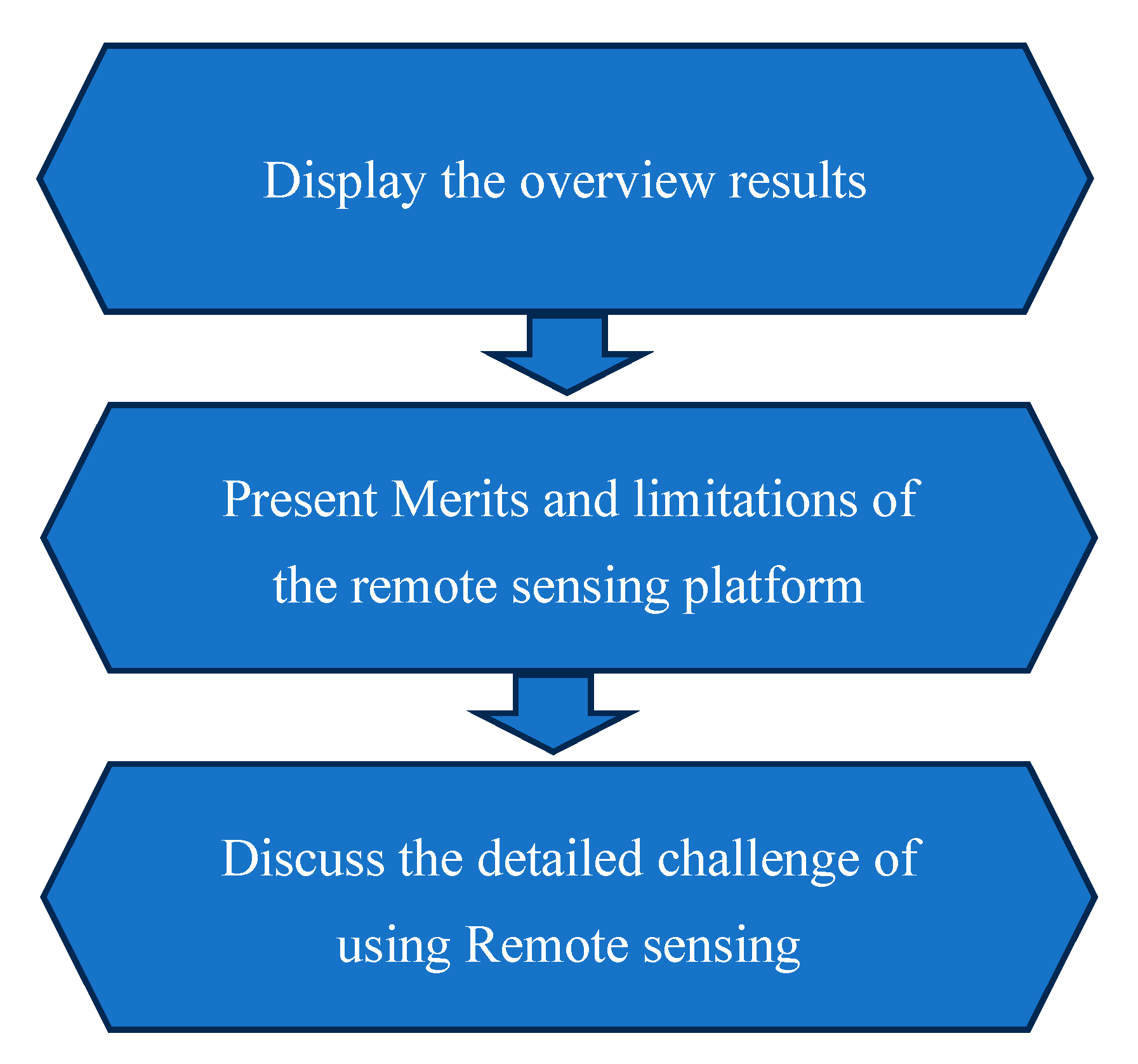
All collected papers were classified based on the challenges they faced. The primary purpose of this review paper is to assist in advancing the understanding, knowledge base, and practical implementation of remote sensing technologies in the construction industry. It may help support the development of robust methodologies, address challenges, and pave the way for the effective integration of remote sensing into construction management processes. The structure of the Results section is shown in Figure 3 and comprises three main components, which display the overview results of the collected paper regarding the frequency of challenge types and the frequency of application of the construction types. Then, the merits and limitations of each remote sensing system platform are summarized. After that, the details of the challenges are discussed.

4.1. Overview

The papers reviewed the challenges facing remote sensing in construction engineering and are distributed according to the type of sensors, the platforms used, and the construction application type.
Based on the scientific papers from the previous literature, Figure 4 shows the percentages of usage of the remote sensing platforms. The use of satellite-based remote sensing in this technology represents more than half of the collected research, followed by aircraft platforms of airborne-based and ground-based remote sensing at 33.33% and 10.53%, respectively.

4.2. Merits and Limitations of Each Remote Sensing Type

This section aims to provide an overview and understanding of the strengths and weaknesses of each platform. This information is crucial for researchers, practitioners, and decision-makers considering using remote sensing technologies for their specific applications. Different remote sensing platforms have their own merits and limitations, as shown in Table 2.
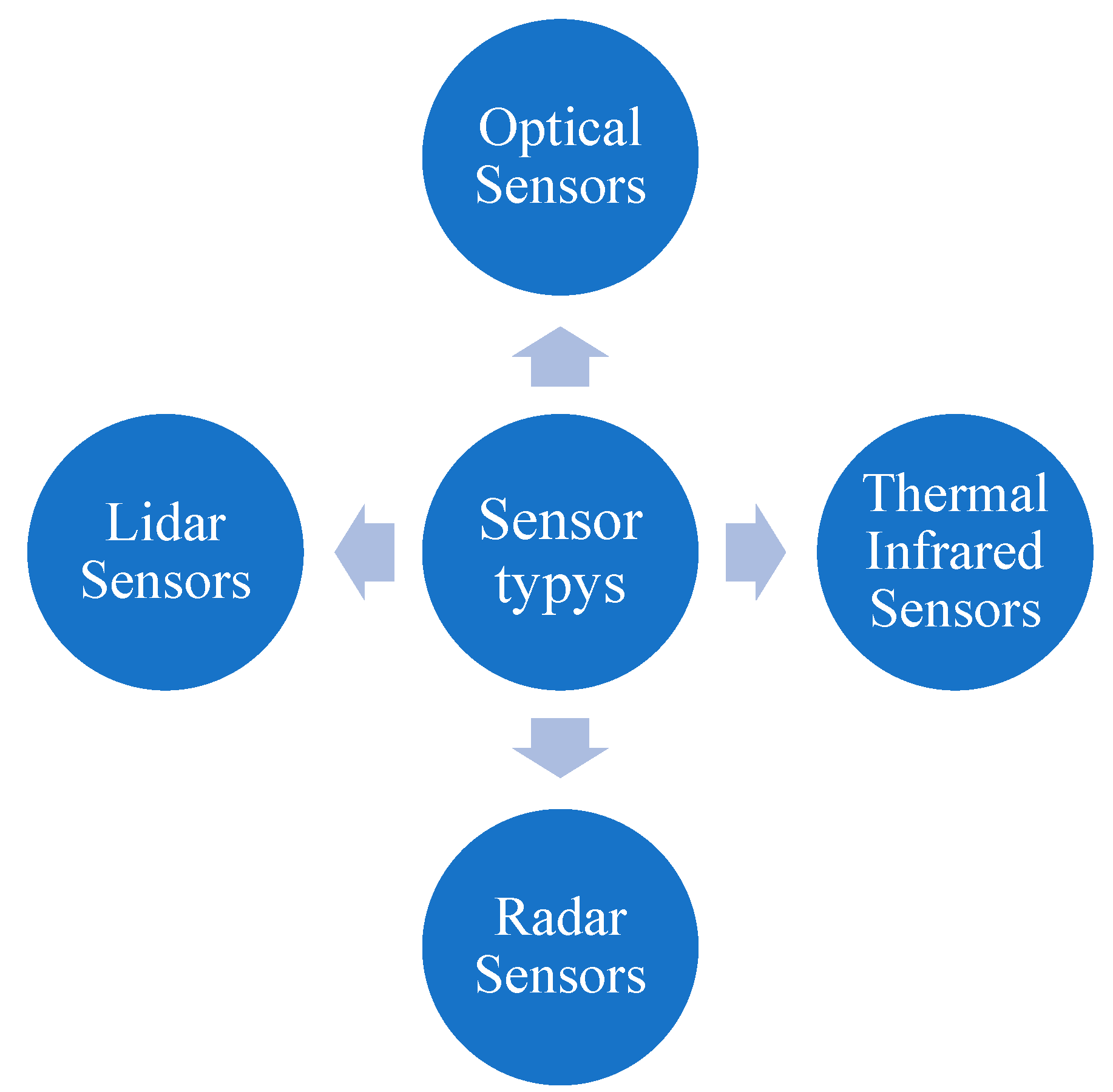
It is important to note that these merits and limitations can vary depending on specific sensor configurations, technologies, and applications within each platform. The commonly used sensors are optical, thermal infrared, Radar, and Lidar sensors, as shown in Figure 5. Therefore, different remote sensors used in remote sensing have their own merits and limitations, as shown in Table 3.

4.3. Challenge of Using Remote Sensing in Construction Management

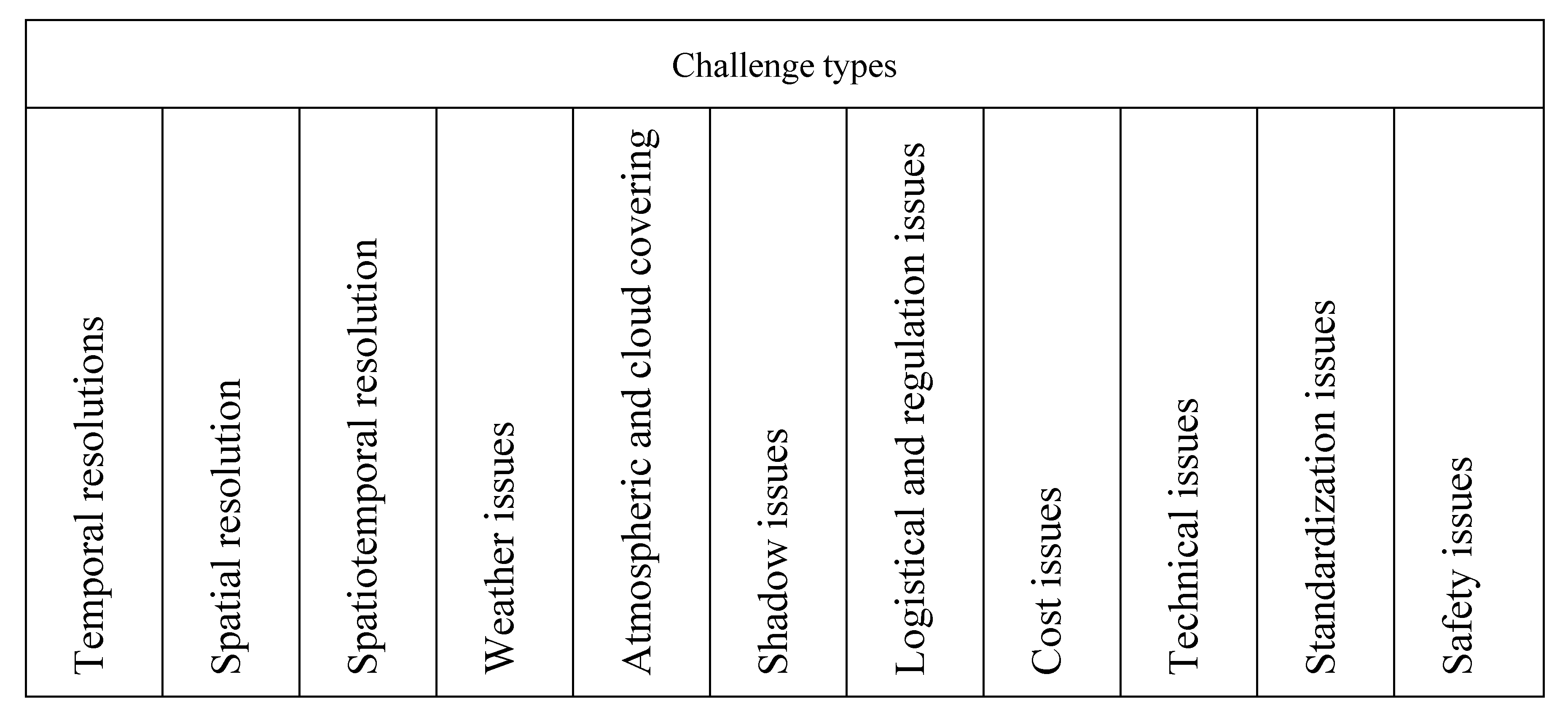
This section deals with the challenge of utilizing remote sensing in construction management in detail. We address and discuss some of these issues. The section is divided into five subsections depending on the challenge types shown in Figure 6.
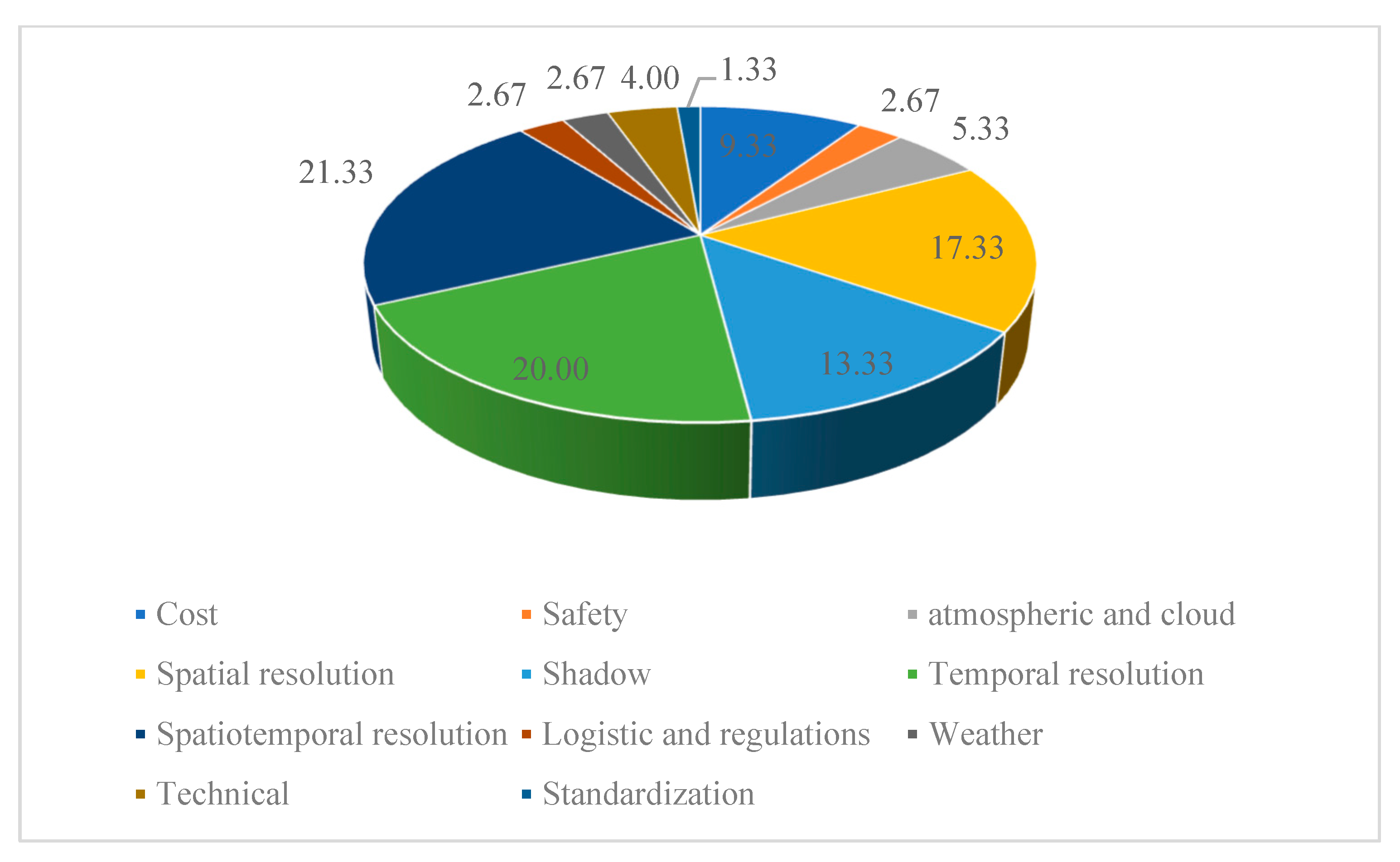
Concerning the project types examined in the reviewed literature, as shown by 44 peer-reviewed articles, they are mostly concentrated on temporal resolution, spatial resolution, and shadow issues and buildings (20%, 17.33, and 13.33%, respectively). These results are depicted in Figure 7.

4.3.1. Temporal Resolutions

Low temporal resolutions have detrimental effects on the analysis of different civil engineering problems. For example, several studies have considered the influence of temporal resolution on rockfall inventories but either used monthly or less-frequent surveys [53], consisted primarily of spatially independent rockfalls [54], or were able to detect minimal volume changes [55,56]. Corbari et al. [57] developed a model to provide estimates continuously in time data using satellite land surface temperature. Their model is utilized in hydrological applications. These models can then overcome the limitations of the instantaneous estimates during the satellite overpass.
For the enhancement of temporal resolution, a sensitivity analysis performed by van Duynhoven and Dragićević [58] was used to explore LSTM (long short-term memory) response to changing geospatial data characteristics to evaluate the impact of increasing temporal resolution. It is hypothesized that coarser temporal resolutions impede a method’s performance. They evaluated the effectiveness of data-driven approaches such as LSTM for land cover change applications where the amount of change is typically small or occurs at slow rates over long periods. In addition, Feng et al. [59] developed a model to quantify the spatial and temporal changes of environmental impacts during and after road construction in China using different spatial zones. They pointed out that a long time series of remotely sensed data is key in capturing some aspects of ecosystem changes caused by roads. They developed a new general approach, using remote sensing data across different times for change detection and quantifying the environmental impacts of road construction.
On the other hand, due to the low temporal resolution of the remote sensing systems based on the satellite and manned aircraft platforms, these platforms are less effective for managing nonlinear, local construction projects such as residential and commercial buildings or industrial structures [1]. Therefore, Wickramasinghe et al. [8] addressed this issue and stated that the accuracy of co-registering multi-temporal images is crucial for detecting changes. The smaller the size of the monitoring object, the higher the co-registration accuracy required.

4.3.2. Spatial Resolution

Spatial resolution indicates the smallest object that can be resolved from the aerial imagery. Spectral resolution is the ability of a sensor to distinguish between wavelength intervals in the electromagnetic spectrum (bands in aerial imagery).
Several investigations have examined reasonably high-spatial-resolution ground-based LiDAR and photogrammetric rockfall monitoring systems, which enable the identification of rockfalls more minor than 1 m3. For instance, 78 terrestrial LiDAR scans of a rock slope supported by a receding glacier were carried out by [60].
Satellite land surface temperature (LST) has a limit in spatial resolution. It is mainly between 1000 m for MODIS data and 100 m for LANDSAT data, which is lower than the range for visible near-infrared bands. Therefore, disaggregation techniques are needed to recover high-spatial-resolution information [57,61]. In contrast, several satellite data from passive or active sensors are available for the retrieval of superficial soil moisture with a pixel resolution of a few centimeters [62,63]. Chen et al. [64] utilized remote sensing techniques to identify and assess waste in urban construction. They pointed out that the traditional method faced difficulties in extracting and identifying information related to urban construction waste by using the traditional single spectral feature analysis method due to the problem of spectral confusion with construction waste. In addition, the composition of construction waste is complex, and its spectral features are also complex. To address the issue, they utilized multisource remote sensing image resources with high spatial and temporal resolution.
Corbari et al. [57] improved the pixel-wise image accuracy to estimate the evapotranspiration and soil moisture estimates using remotely sensed land surface temperature as well as calibrated soil and vegetation parameters of an energy–water balance model using the thermodynamic equilibrium temperature. They evaluated the effect of the irrigation distribution on the pixel-wise correctness of land surface temperature estimates. In addition, the thermal infrared data is a way to improve the spatial resolution of pixel disaggregation. Pixel disaggregation in remote sensing refers to the process of breaking down mixed pixels, which contain a combination of different land cover types, into their components for more accurate classification and analysis of remote sensing images. Various methods have been proposed to address this issue, such as using super-pixel algorithms combined with clustering techniques. This method determines the soil moisture [62,63].
Regarding the spatial resolution of airborne-based remote sensing, aerial imagery has limitations on spectral resolution. Most aerial imagery has three bands (the visible bands) or four spectral bands (thermal infrared and the visible bands). In contrast, satellite images have more bands or higher spectral resolution. For example, one of the famous satellite imaging programs, Landsat-8, has a spectral resolution of 11 bands. To leverage the strengths of UAV and satellite imagery, researchers have proposed various methods for fusing these data sources to improve their utility in applications such as classification. One approach is to use deep convolutional neural networks (DCNNs) for land cover classification based on fused image/LiDAR data [65]. Additionally, a novel fusion method has been proposed for pansharpening using Chinese Gaofen satellite data and drone data [66]. Deep learning approaches, specifically, convolutional neural networks (CNNs), have also been applied to UAV-based remote sensing image analysis for crop/plant classification [67]. Furthermore, a multi-modal fusion-based earth data classification (MMF-EDC) model has been developed, which combines histogram of gradients (HOG), local binary patterns (LBP), and residual network (ResNet) models for dynamic scene classification [68]. Many remote sensors, such as LiDAR, have recently become commercially available in miniaturized forms suitable for operation on UASs [1,23].
The fusion of spatial and spectral information from remote sensing data enables the differentiation and classification of various materials and objects, such as construction waste, with enhanced accuracy and reliability [69]. This integration of spatial and spectral features allows for the precise identification and mapping of specific targets of interest, leveraging the strengths of hyperspectral sensors and lidar scanners in synergistic classification approaches [69]. Therefore, leveraging the spatial–spectral integration capabilities of remote sensing data can significantly enhance the identification and monitoring of construction waste, thereby enabling more effective waste management practices in the construction industry. Studies have shown that the fusion of data from heterogeneous sensors, including multispectral, thermal infrared, and synthetic aperture radar (SAR), can improve the sensitivity to changes in the spatial geometry of construction waste sites [70]. Additionally, the use of high-resolution UAV multispectral and thermal remote sensing, along with satellite sensors like Landsat and Sentinel-2, allows for the extraction of key indicators such as the Normalized Difference Vegetation Index (NDVI) and Land Surface Temperature (LST) to characterize waste sites and monitor environmental impacts over time [71].

4.3.3. Spatiotemporal Resolution

Obtaining suitable remote sensing data with the required spatial and temporal resolution can be challenging. Data availability may be limited, especially for specific study areas or periods. High-quality data can also be costly [72]. Therefore, remote sensing spatiotemporal fusion models have been developed to merge high-spatial-resolution data with high-temporal-resolution data to produce high-spatiotemporal-resolution data.
Butcher et al. [73] examined the impacts of low spatial resolution relative to the temporal resolution on long-term slope monitoring results in assessment changes in a rock slope in Majes. They used automatically recorded images collected daily combined with multi-epoch structure-from-motion photogrammetric processing approaches. In addition, structure-from-motion is a computer vision technique to reconstruct three-dimensional structures from a series of two-dimensional images or video footage. It is commonly applied in photogrammetry, remote sensing, computer graphics, and other fields where 3D modeling is required [73].
Wickramasinghe et al. [8] stated that airborne-based remote sensing provides a view of the spatiotemporal changes of the Earth’s surface for general land-cover and land-use classes and detailed attributes at each geographical location based on a combination of better temporal resolutions. Employing such very-high-resolution (VHR) images to monitor activities such as highway or railway construction is promisingly feasible. The spatiotemporal pattern has been identified as a suitable parameter for land use, land cover mapping, and change detection. There is inconsistency between the spatial and temporal resolutions. According to le Maire et al., due to technological and budget constraints, airborne-based remote sensors must compromise among spatial resolution, temporal resolution, and repeat periods, presenting complex spatiotemporal heterogeneity [74]. In addition, Sun et al. [75] utilized high spatial and temporal resolutions to help improve the accuracy of the estimation of crop planting acreage and contribute to the formulation and management of agricultural policies. Using a spatial and temporal adaptive reflectance fusion model, they employed three sensor datasets to obtain one normalized difference vegetation index time series dataset with a 5.8 m spatial resolution.

4.3.4. Weather Issues

According to the Federal Aviation Administration (FAA) (2016), appropriate circumstances include sunshine, no fog, no wind shear or gusts, and no rain. Drone crashes and significant effects on unmanned airborne operations might result from strong winds. Furthermore, strong winds might degrade the quality of aerial photo collection, resulting in hazy photos that are unusable for processing. As a general rule of thumb, small unmanned airborne systems can fly in winds that are two-thirds of their maximum speed. However, winds between 16 and 48 km/h (10 and 30 mi/h) can be used to fly the majority of commercial UASs. Although water-resistant or water-proof small unmanned airborne systems are already available, avoiding flying during wet or snowy weather is also advised since water can harm various mechanical, electrical, or photographic components (FAA 2016). Additionally, it is advised to forego flying when it is cloudy to prevent collisions from poor visibility.

4.3.5. Atmospheric and Cloud Covering

Several studies have dealt with atmospheric and cloud-cover issues. This issue is notable for satellite-based remote sensing.
Many studies have stated the detrimental effects of atmospheric issues on the use of remote sensing. For example, remote sensing images often suffer from missing information problems such as dead pixels and thick cloud cover because of the satellite sensor working conditions and the atmospheric environment [76]. Kadhim and Mourshed [77] presented the issue of point-cloud sparsity and data misalignment. Elevation data-based methods may suffer from point-cloud sparsity and misalignment, necessitating data preprocessing to address these issues. Park et al. [72] explained that the Earth’s atmosphere can interfere with remote sensing measurements, causing distortions and errors in the data. Atmospheric conditions, such as clouds, aerosols, and atmospheric scattering, can affect the accuracy and reliability of remote sensing data. On the other hand, Corbari et al. [57] displayed the effect of the cloud issue and provided a developed model to overcome this issue based on visible and thermal infrared satellite images and instantaneous estimates at the time of the satellite overpass.

4.3.6. Shadow Issues

The issue is made more difficult by shadow effects. Shadow effects in satellite images pose challenges in various applications such as classification, change detection, image interpretation, object detection, and recognition [78]. Shadows can hinder the precision of information extraction and change identification, affecting the accuracy of subsequent image applications [79,80]. Existing shadow-detection methods still face issues of shadow omission and nonshadow misclassification in high-resolution multispectral satellite remote sensing images [81]. To address these problems, novel algorithms and approaches have been proposed, including the use of different color spaces, thresholding methods, and morphological techniques [82]. These methods aim to highlight shadow areas, create shadow masks, and remove shadows from satellite images. Additionally, supervised machine learning models like Support Vector Machines (SVM) and statistical models like CRF have been utilized for shadow detection and removal. These effects can be disregarded when working with moderate- and high-quality photos but not very-high-resolution images [8]. It might be challenging to precisely extract an object’s footprints from very-high-resolution photos when it appears displaced or distorted. Because shadow effects vary depending on the sun elevation and sensor viewing angle, they further complicate the study [8].
Kadhim and Mourshed [77] provided a developed method to address these challenges; the proposed algorithm mainly consists of a shadow-detection algorithm, utilizing graph theory and morphological fuzzy processing, simulating artificial-shadow simulation, and determining the Jaccard similarity coefficient. A refined version of the shadow-detection algorithm was applied to identify the actual shadow regions of buildings in VHR satellite images. Then, graph theory and morphological fuzzy processing techniques were utilized to identify the buildings’ 2D footprint geometries. After that, artificial shadow regions were simulated using the identified building footprints and solar information in the image metadata at predefined height increments. The difference between the actual and simulated shadow regions at each height increment was computed using the Jaccard similarity coefficient. The estimated building height corresponds to the height of the simulated shadow region that yields the maximum value for the Jaccard index.
Liu et al. [83] introduced the challenges of shadows for UAS images. Shadows are formed in UAV images due to imaging and lighting directions. Shadows can lead to the loss of color and texture details in the shadowed regions, affecting the quality of the images and subsequent image processing tasks. In addition, the UAS remote sensing images often have complex surface features and multiple shadows, which pose difficulties in accurately detecting and compensating for shadows. Existing methods designed for simple scenes may result in color distortion or texture information loss in the shadow compensation process. To address these challenges, they developed a shadow removal algorithm based on color and texture equalization compensation of local homogeneous regions. The algorithm includes block-based image splitting, shadow detection, and homogeneous region extraction. The UAS imagery was divided into blocks using a sliding window approach. A new shadow detection index (SDI) was introduced, and threshold segmentation was applied to identify the shadow mask. Homogeneous regions were extracted using LiDAR intensity and elevation information. The information on nonshadow objects within the homogeneous regions was utilized to restore the missed information in the shadow objects. The proposed algorithm aims to effectively detect and compensate for shadows in UAS remote sensing images, considering the color and texture details and preserving the surface feature information in nonshadow regions. The algorithm’s results demonstrate its effectiveness in both subjective and objective evaluations.
Xie et al. [84] presented the challenges of complex environments and shadow issues with complex shadow shapes. Remote sensing imagery captures the complex environment of urban areas, including various factors such as different sun azimuth and altitude angles, satellite azimuth and altitude angles, and terrain variations. These factors can affect the accuracy of building height estimation. In densely built areas, the shadows of buildings can adhere to each other, making it difficult to accurately determine the height of individual buildings based on their shadows. The traditional method of using shadow length to calculate building height faces challenges when dealing with complex shapes of building shadows. To address these challenges, they proposed a multi-scene building height estimation method based on shadows in high-resolution imagery. The proposed method includes shadow analysis, multi-scene classification, regularization extraction, and calculation of the shadow length. The characteristics of building shadows, such as shape, distribution density, and regional terrain differences, are analyzed to understand the scene and improve height estimation accuracy. The building scenes are divided into three types: ordinary scenes, dense scenes, and complex terrain scenes. This classification helps in establishing specific height estimation models for different scenarios. A regularized building shadow extraction method is proposed to address the problem of shadow adhesion in dense areas. This method effectively separates overlapping shadows and provides more-accurate height estimation. A method combining the fishnet and Pauta criterion was proposed to calculate shadow length and overcome the challenges posed by complex shadow shapes. This approach provides more reliable data for building-height estimation.
Yu et al. [85] utilized Landsat-8 thermal infrared sensor data to study the influence of building shadows on the land surface temperature. The main challenges were the extraction of building shadows and connecting the building’s shadow to the land surface temperature at the pixel scale. They combined remote sensing data, spatial analysis techniques, and quantitative modeling to address the challenges of extracting and analyzing building shadows and land surface temperature data.
Dong et al. [86] highlighted several difficulties related to inclination and shadow issues in remote sensing in building extraction from remote sensing imagery:
  • Obstruction by tall trees: Tall trees can obstruct buildings in the images, leading to incomplete or inaccurate data.
  • Sensor observation angle: The observation angle of the sensor can cause anomalies in the shape of buildings, making it challenging to extract accurate information.
  • Diversity of building materials and structures: The wide variety of exterior building materials and structures makes it difficult to develop consistent building extraction models.
Dong et al. [86] proposed utilizing shadow information as a valuable cue for building detection and feature description. Shadows between buildings can provide vital information for accurately identifying and describing buildings in remote sensing images. The paper also discusses the advantages and disadvantages of various building-shadow-detection methods and provides an overview of datasets and evaluation metrics commonly used in building-shadow studies.

4.3.7. Logistical and Regulation Issues

These issues were identified by Wickramasinghe et al. [8] as follows: The remotely sensed data were obtained upon request from the relevant progress monitoring authorities and were obtained from either airborne- or ground-based platforms. Every building site should have a capture device; such monitoring should receive extra attention. Drone surveying flights in some metropolitan regions are severely prohibited without specific security approval.
Zhang et al. [1] noted that most governments use regulations to restrict the use of unmanned aerial vehicles. Any unmanned aircraft used for commercial purposes in the US must be registered with the FAA, adhere to Part 107 laws and regulations, and be flown by a licensed remote pilot (FAA, 2016). The following are some of the FAA’s operating requirements: (1) never fly near manned aircraft; (2) never fly higher than 400 feet above the ground, or if you do, stay within 400 feet of a structure; (3) minimum weather visibility of three miles from the control station; (4) never operate from a moving aircraft; (5) never operate from a moving vehicle unless it is over a sparsely populated area; (6) only operate during the day; and (7) may not operate over any people who are not directly involved in the operation, under a covered structure, or inside a covered stationary vehicle. Additionally, using UASs for high-resolution spatial data acquisition can aid in monitoring construction progress and detecting unauthorized activities, thereby supporting regulatory compliance [3]. Furthermore, implementing a service-oriented framework for monitoring construction progress and evaluating effects using remote sensing technology can streamline data acquisition processes and improve decision-making in modern agricultural parks [87].

4.3.8. Cost Issues

Cost issues pose several challenges for utilizing remote sensing technologies in the construction industry. The cost issues related to using remote sensing in construction projects can be mitigated through various solutions proposed in the literature. One approach involves the integration of real-time location systems (RTLSs) like GPS and UWB with other sensing technologies such as RFID, WSN, and digital imaging to improve automated data acquisition efficiency [3]. One of the key challenges is the need for automated site data acquisition, which can be labor-intensive and not reliable enough for various construction purposes [88]. Another challenge is the development and application of various types of drones and sensors, which can open up new data collection and analysis possibilities but also come with their own costs [89]. Additionally, the abundance of UAS-based sensing systems available today makes it difficult to identify the best option for construction projects, and the associated risk factors of UAS operations at construction sites need to be considered [90]. Finally, the adoption of remote sensing technologies in construction practices may face barriers such as increased liability and legal challenges, which can impact the overall cost effectiveness of implementation [91].
The cost issues related to the utilization of satellite images are addressed in several papers. One of the main hurdles is the interpretation of the image data, which requires advanced deep learning techniques for accurate analysis [92]. Another challenge is the appropriate adjustment of costs to reflect project location. Traditional methods, such as the nearest neighbor (NN) method, may not accurately account for economic conditions. However, a proposed method using nighttime light satellite imagery (NLSI) shows promise in effectively estimating location adjustment factors and improving cost estimates for construction projects [93]. Additionally, the use of Construction IT (CIT) technologies, such as 4D modeling and 3D design, presents challenges in terms of integrating these technologies into existing work practices and addressing mismatches between individual reasoning and CIT features [94]. Overall, these papers highlight the need for advanced techniques and careful consideration of contextual factors when using satellite image technologies in the construction industry.
Unmanned aerial vehicles are a financially viable aerial data-collecting platform for construction management [95]. According to research, the two main factors influencing the decision to use unmanned aerial vehicles in construction are cost savings and time efficiency [96]. Numerous studies have demonstrated that unmanned aerial vehicle platforms are a competitive substitute for conventional, more expensive ground-based surveying techniques, even though they are more economical [23]. For example, a recent study [24] investigated the applicability of UASs to scan pavement surface distress conditions and found that the results were accurate to 4 mm. [1]. The hardware for unmanned aerial vehicles may not be more expensive than conventional survey equipment like transits, theodolites, and total stations. On the other hand, unmanned aerial vehicles can cut survey times from two weeks to thirty minutes, saving a 99.5% decrease in time and, eventually, labor expenses). A construction company can save $50,000 to $60,000 annually on survey work by utilizing UASs). Aerial-based surveys can save all costs by between 40% and 90% when compared to those for manned aircraft, contingent upon the technical characteristics of the aerial images (e.g., spatial resolution) and the physical environment (e.g., size) of the study site [1,97].

4.3.9. Technical Issues

The technical issues in using remote sensing in construction projects are being addressed through innovative solutions proposed in the research papers. These solutions comprise the implementation of intelligent monitoring devices like wireless cement sensors with the Enhanced Pillar Algorithm (EPA) for efficient strain monitoring [98], the integration of real-time location systems (RTLSs) with other sensing technologies for automated data acquisition [3], the examination of UAV-based sensing systems for construction management and civil engineering applications [87], the application of remote sensing technology for eco-environment monitoring and ecological restoration estimates in construction projects [99], and the proposal of a technical process for monitoring soil erosion caused by construction projects using remote sensing images [100].
The use of remote sensing technologies in the construction industry presents several technical challenges. These challenges include data heterogeneity, regulatory and legal concerns, technical limitations, data processing challenges, and training and expertise [94]. For example, Wang et al. [101] indicated a lack of techniques to analyze mathematical semantics. There is a lack of methods to directly manage and analyze the mathematical semantics of remote sensing indices. This limitation hinders effective knowledge management and analysis. In addition, there is also limited literature on the integration of RFID sensors and unmanned aircraft for construction research [102,103], making its applications primarily focused on tracking construction materials’ location and quantity information [1]. Schnebele et al. [11] addressed ample spatial coverage: Remote sensing techniques offer the advantage of covering large areas, but this can also present challenges regarding data acquisition, storage, and processing. Managing and analyzing vast amounts of remote sensing data can be complex and time-consuming.
Integrating observations from different sources such as LiDAR scans, UASs, handheld cameras, and BIM through resource description framework (RDF) graphs can help overcome data heterogeneity issues and enable holistic analysis of construction sites [88]. Camera-based and laser-based UAV sensing systems have been explored in the context of construction management and civil engineering, but risk factors associated with UAS operations at construction sites need to be considered [90]. Remote monitoring systems using UASs can enhance resource utilization, citizen service quality, and construction progress tracking, but data security during transmission is a risk that needs to be addressed [6]. Automated site data acquisition, including remote sensing technologies, can improve the efficiency of construction operation tracking, but further research is needed on fusion-based data capturing and processing [3].

4.3.10. Standardization Issues

Standardization issues in utilizing remote sensing for construction projects can be addressed through various solutions proposed in the research papers. One key solution involves intensifying and standardizing project management processes, establishing centralized management platforms that cover all project aspects from initiation to acceptance and payment [3]. Additionally, the fusion of data from different digital sensors, such as cameras, laser scanners, and radar systems, can significantly improve the quality of geometric and radiometric data, providing more comprehensive information for construction projects [104].
Unmanned airborne systems and sensor manufacturers need to come up with their own data formats and processing procedures, introducing many issues, which include excessive processing burden, lack of standardization, lack of interoperability, and lack of integration with data and information systems such as BIM [1].

4.3.11. Safety Issues

Various innovative solutions have been proposed to address safety issues in construction projects using remote sensing. One approach involves the development of smart wearable devices equipped with sensors to monitor workers’ health and safety in real-time, detecting falls and abnormal health conditions while providing immediate aid notifications [5]. Additionally, the integration of unmanned aerial vehicles (UASs) for construction safety monitoring has shown promising results, with systems achieving high accuracy in detecting construction site targets and behaviors, leading to improved safety and progress monitoring [3]. Furthermore, incorporating UASs into safety management systems has facilitated hazard identification and corrective actions, contributing to Safety-I and Safety-II practices in everyday operations and highlighting resilience mechanisms and areas for improvement in safety protocols [105]. In addition, the adoption and learning of IoT technologies for safety improvement in the construction sector faces barriers such as the large investment required, concerns about technical support availability, and the lack of information on the effectiveness of health and safety technology [106]. The risk of data security during transmission is also a concern, requiring the development of secure architectures that consider the limited processing capabilities of UAV agents and the distributed nature of the system [6]. Additionally, the use of wearable Internet of Things (WIoT) devices for safety and health monitoring raises privacy and security concerns regarding the collection, transmission, and processing of construction safety and health data [107]. Therefore, addressing these challenges is crucial to ensure the safe and secure implementation of remote sensing technologies in the construction industry. The integration of unmanned aerial systems in construction poses safety difficulties due to its complexity and the possibility of accidents and injuries [108]. Lithium-polymer (Li-Po) batteries are the most-often-used battery type for UASs. Li-Po battery use, charging, and discharging can be risky, though, as there is a chance of fire or explosion. Li-Po battery usage requires extra caution from UAS operators. [1].

5. Practical Implications

These findings have several practical implications for construction professionals. For example, construction companies have reported significant cost reductions and productivity increases through remote sensing technologies. Communication and collaboration become effective, measurements are accurate, safety is improved, and data insights are obtained faster. Construction professionals can leverage these benefits by adopting remote sensing in their projects. In addition, remote sensing technologies contribute to sustainable development in the construction industry. They minimize the environmental footprint of construction activities by providing accurate data for environmental management and reducing unnecessary physical travel to job sites. Construction professionals can align their projects with sustainability goals by incorporating remote sensing into their practices.
Comprehending the challenges and limitations of remote sensing technologies, such as shadow, spatial, and temporal resolution issues, enables construction professionals to make informed decisions when selecting and utilizing these technologies in their projects. In addition, awareness of the challenges related to remote sensing technology implementation allows for better resource allocation, ensuring that resources are utilized effectively and efficiently throughout the project lifecycle. Understanding the hurdles and limitations of satellite, airborne, and ground-based remote sensing technologies helps construction professionals anticipate and proactively address potential difficulties, thereby minimizing risks and uncertainties associated with technology implementation. Moreover, the suggested research directions from this review encourage further exploration and innovation in the field of remote sensing in construction, leading to improved methodologies, tools, and techniques.
Several specific areas need further research to address these challenges. For example, we need an investigation focused on developing advanced algorithms or techniques to mitigate shadow effects in remote sensing data, especially in complex urban environments or areas with significant topographic variations. Moreover, we need an exploration into new technologies or processes that can enhance the spatial resolution of remote sensing data, especially for the detailed monitoring and analysis of construction sites and structures, and to research developing automated data processing and analysis techniques for remote sensing data in construction applications to streamline data interpretation, improve efficiency, and facilitate timely decision-making.

6. Recommendation for Future Research

Further research can focus on developing algorithms or techniques to improve the resolution and accuracy of remote sensing data in shadowed areas. This research could involve exploring advanced image processing methods or integrating multiple data sources to enhance shadow detection and removal. Further research can focus on developing effective methodologies for integrating remote sensing data with BIM models. This integration can enhance the accuracy of construction planning, progress tracking, and facility management, requiring investigations into data interoperability, automatic feature extraction, and seamless data exchange between remote sensing and BIM platforms. Moreover, further research can focus on addressing the cost-effectiveness and scalability challenges associated with the adoption of remote sensing technologies in the construction industry. This may involve investigating cost reduction strategies, exploring the use of affordable sensors or platforms, and assessing the scalability of remote sensing solutions for large-scale construction projects.

7. Conclusions

Remote sensing technologies offer significant advantages and contribute to the advancement of the construction industry. They enhance accuracy, reduce costs, improve safety, and minimize the environmental impact of construction activities. This literature review identified several challenges faced by remote sensing technologies in construction. These challenges include resolution limitations, temporal and spatial constraints, data collection and integration issues, and the need for skilled personnel. However, solutions have been proposed to address these challenges, such as integrating remote sensing with other technologies like GPS, RFID, and BIM models. The benefits of remote sensing in construction include improved communication and collaboration, more accurate measurements, enhanced safety, and faster data analysis. The results highlight the growing significance and widespread adoption of UASs and satellite remote sensing in construction activities. These technologies are increasingly valuable for preconstruction preparation, tracking project progress, ensuring safety, and managing environmental concerns. The findings highlight the importance of further research and development in remote sensing applications for the construction industry. Future work should address the remaining challenges and explore innovative approaches to maximize the potential of remote sensing technologies in construction operations.

Funding

The author would like to acknowledge the Researcher Supporting Project number (RSP2024R282), King Saud University, Riyadh, Saudi Arabia.

Data Availability Statement

The raw data supporting the findings of this paper are available on request from the corresponding author.

Conflicts of Interest

The author declares no conflicts of interest.

References

  1. Zhang, S.; Bogus, S.M.; Lippitt, C.D.; Kamat, V.; Lee, S. Implementing Remote-Sensing Methodologies for Construction Research: An Unoccupied Airborne System Perspective. J. Constr. Eng. Manag. 2022, 148, 03122005. [Google Scholar] [CrossRef]
  2. Sun, B. Application of satellite remote sensing in the construction and comprehensive management of smart cities. In Advances in Civil Engineering and Environmental Engineering; CRC Press: Boca Raton, FL, USA, 2023. [Google Scholar]
  3. Moselhi, O.; Bardareh, H.; Zhu, Z. Automated data acquisition in construction with remote sensing technologies. Appl. Sci. 2020, 10, 2846. [Google Scholar] [CrossRef]
  4. Kushwaha, P.; Dubey, S. Application of remote sensing in civil engineering. Southeast Asian J. Case Rep. Rev. 2023, 9, 74–76. [Google Scholar] [CrossRef]
  5. Liang, H.; Cho, J.; Seo, S. Construction Site Multi-Category Target Detection System Based on UAV Low-Altitude Remote Sensing. Remote Sens. 2023, 15, 1560. [Google Scholar] [CrossRef]
  6. Beevi, L.S.; Muthusundari, S.; Sakthi, D.V.; Subhashini, G. Blockchain-Based Remote Construction Monitoring Using UAV in SITL Simulation. In Proceedings of Third International Conference on Sustainable Expert Systems: ICSES 2022; Lecture Notes in Networks and Systems; Springer Nature Singapore: Singapore, 2022. [Google Scholar]
  7. Vu, T.-T.; Wickramasinghe, D.; Ahmed, M.; Maul, T. Remote Sensing Monitoring Large-Scale Repetitive Construction Projects. In Proceedings of the 35th EARSeL Symposium—European Remote Sensing: Progress, Challenges and Opportunities, Stockholm, Sweden, 15–18 June 2015. [Google Scholar]
  8. Wickramasinghe, D.C.; Vu, T.T.; Maul, T. Satellite remote-sensing monitoring of a railway construction project. Int. J. Remote Sens. 2018, 39, 1754–1769. [Google Scholar] [CrossRef]
  9. Aricak, B. Using remote sensing data to predict road fill areas and areas affected by fill erosion with planned forest road construction: A case study in Kastamonu Regional Forest Directorate (Turkey). Environ. Monit. Assess 2015, 187, 7. [Google Scholar] [CrossRef]
  10. Behnam, A.; Wickramasinghe, D.C.; Ghaffar, M.A.A.; Vu, T.T.; Tang, Y.H.; Isa, H.B.M. Automated progress monitoring system for linear infrastructure projects using satellite remote sensing. Autom. Constr. 2016, 68, 114–127. [Google Scholar] [CrossRef]
  11. Schnebele, E.; Tanyu, B.F.; Cervone, G.; Waters, N. Review of remote sensing methodologies for pavement management and assessment. Eur. Transp. Res. Rev. 2015, 7, 2. [Google Scholar] [CrossRef]
  12. Zhang, H.; Zhang, Y.; Gao, T.; Lan, S.; Tong, F.; Li, M. Landsat 8 and Sentinel-2 Fused Dataset for High Spatial-Temporal Resolution Monitoring of Farmland in China’s Diverse Latitudes. Remote. Sens. 2023, 15, 2951. [Google Scholar] [CrossRef]
  13. Drusch, M.; Del Bello, U.; Carlier, S.; Colin, O.; Fernandez, V.; Gascon, F.; Hoersch, B.; Isola, C.; Laberinti, P.; Martimort, P.; et al. Sentinel-2: ESA’s Optical High-Resolution Mission for GMES Operational Services. Remote Sens. Environ. 2012, 120, 25–36. [Google Scholar] [CrossRef]
  14. Claverie, M.; Ju, J.; Masek, J.G.; Dungan, J.L.; Vermote, E.F.; Roger, J.-C.; Skakun, S.V.; Justice, C. The Harmonized Landsat and Sentinel-2 surface reflectance data set. Remote. Sens. Environ. 2018, 219, 145–161. [Google Scholar] [CrossRef]
  15. Mandanici, E.; Bitelli, G. Preliminary comparison of sentinel-2 and landsat 8 imagery for a combined use. Remote. Sens. 2016, 8, 1014. [Google Scholar] [CrossRef]
  16. Chastain, R.; Housman, I.; Goldstein, J.; Finco, M.; Tenneson, K. Empirical cross sensor comparison of Sentinel-2A and 2B MSI, Landsat-8 OLI, and Landsat-7 ETM+ top of atmosphere spectral characteristics over the conterminous United States. Remote Sens. Environ. 2019, 221, 274–285. [Google Scholar] [CrossRef]
  17. Ferrero, A.M.; Forlani, G.; Roncella, R.; Voyat, H.I. Advanced geostructural survey methods applied to rock mass characterization. Rock Mech. Rock Eng. 2009, 42, 631–665. [Google Scholar] [CrossRef]
  18. Kennedy, R.E.; Townsend, P.A.; Gross, J.E.; Cohen, W.B.; Bolstad, P.; Wang, Y.; Adams, P. Remote sensing change detection tools for natural resource managers: Understanding concepts and tradeoffs in the design of landscape monitoring projects. Remote Sens. Environ. 2009, 113, 1382–1396. [Google Scholar] [CrossRef]
  19. Jianzhong, S.; Zhimo, C.; Zhixiang, J.; Jing, R. Urban Construction Planning and Aerial Remote Sensing Information System of Shanghai. In Geosciences and Human Survival, Environment, Natural Hazards, Global Change; CRC Press: Boca Raton, FL, USA, 2023. [Google Scholar]
  20. Kaamin, M.; Fahmizam, M.A.F.; Jefri, A.S.; Sharom, M.H.; Kadir, M.A.A.; Nor, A.H.M.; Supar, K. Progress Monitoring at Construction Sites Using UAV Technology. IOP Conf. Ser. Earth Environ. Sci. 2023, 1140, 012025. [Google Scholar] [CrossRef]
  21. Hasan, A.; Qadir, A.; Nordeng, I.; Neubert, J. Construction Inspection through Spatial Database. In Proceedings of the 34th International Symposium on Automation and Robotics in Construction and Mining (ISARC 2017), Taipei, Taiwan, 28 June–1 July 2017. [Google Scholar]
  22. Vincke, S.; Bassier, M.; Hernandez, R.d.L.; Dejaeghere, I.; Carbonez, K.; Vergauwen, M. Remote sensing data as basis for the modelling and reassembly of dismantled heritage structures. Int. Arch. Photogramm. Remote Sens. Spat. Inf. Sci. —ISPRS Arch. 2019, 42, 1187–1194. [Google Scholar] [CrossRef]
  23. Zhang, S.; Lippitt, C.D.; Bogus, S.M.; Neville, P.R.H. Characterizing pavement surface distress conditions with hyper-spatial resolution natural color aerial photography. Remote Sens. 2016, 8, 392. [Google Scholar] [CrossRef]
  24. Zhang, S.; Lippitt, C.D.; Bogus, S.M.; Loerch, A.C.; Sturm, J.O. The accuracy of aerial triangulation products automatically generated from hyper-spatial resolution digital aerial photography. Remote. Sens. Lett. 2016, 7, 160–169. [Google Scholar] [CrossRef]
  25. Yao, S.; Li, L.; Cheng, G.; Zhang, B. Analyzing Long-Term High-Rise Building Areas Changes Using Deep Learning and Multisource Satellite Images. Remote. Sens. 2023, 15, 2427. [Google Scholar] [CrossRef]
  26. Wang, X.; Xing, Q.; An, D.; Meng, L.; Zheng, X.; Jiang, B.; Liu, H. Effects of spatial resolution on the satellite observation of floating macroalgae blooms. Water 2021, 13, 1761. [Google Scholar] [CrossRef]
  27. Roy, S.; Chakraborty, A. Single Image Super-resolution with a Switch Guided Hybrid Network for Satellite Images. arXiv 2020, arXiv:2011.14380. [Google Scholar]
  28. Liu, S.; Hodgson, M.E. Satellite image collection modeling for large area hazard emergency response. ISPRS J. Photogramm. Remote. Sens. 2016, 118, 13–21. [Google Scholar] [CrossRef]
  29. Sehgal, S.; Ahuja, L.; Hima Bindu, M. High Resolution Satellite Image Compression using DCT and EZW. In Proceedings of the International Conference on Sustainable Computing in Science, Technology and Management (SUSCOM), Amity University Rajasthan, Jaipur, India, 26–28 February 2019. Available online: https://ssrn.com/abstract=3350914 (accessed on 5 April 2024).
  30. Huang, C.-L.C.; Munasinghe, T. Exploring Various Applicable Techniques to Detect Smoke on the Satellite Images. In Proceedings of the 2020 IEEE International Conference on Big Data, Big Data 2020, Institute of Electrical and Electronics Engineers Inc., Virtual Conference, 10–13 December 2020; pp. 5703–5705. [Google Scholar] [CrossRef]
  31. Liu, S.; Hodgson, M.E. Optimizing large area coverage from multiple satellite-sensors. GIScience Remote Sens. 2013, 50, 652–666. [Google Scholar] [CrossRef]
  32. Reddy, G. Satellite Remote Sensing Sensors: Principles and Applications. In Geospatial Technologies in Land Resources Mapping, Monitoring and Management: An Overview; Springer: Berlin/Heidelberg, Germany, 2018. [Google Scholar]
  33. Singh, K.D.; Nansen, C. Advanced calibration to improve robustness of drone-acquired hyperspectral remote sensing data. In Proceedings of the 6th International Conference on Agro-Geoinformatics, Fairfax, VA, USA, 7–10 August 2017. [Google Scholar]
  34. Bolt, M.; Prather, J.C.; Horton, T.; Adams, M. Massively Deployable, Low-Cost Airborne Sensor Motes for Atmospheric Characterization. Wirel. Sens. Netw. 2020, 12, 99869. [Google Scholar] [CrossRef]
  35. Na Dong, L.; Tong, J.; Wang, C.Y. The Application of airborne remote sensing technology in land and resources. Appl. Mech. Mater. 2014, 644–650, 4360–4363. [Google Scholar] [CrossRef]
  36. Lee, K.; Noh, H.; Lim, J. Airborne relay-based regional positioning system. Sensors 2015, 15, 12682–12699. [Google Scholar] [CrossRef]
  37. Li, N.; Zhang, Y.; Shi, K.; Zhang, Y.; Sun, X.; Wang, W.; Qian, H.; Yang, H.; Niu, Y. Real-Timeand Continuous Tracking of Total Phosphorus Using a Ground-Based Hyperspectral Proximal Sensing System. Remote Sens. 2023, 15, 507. [Google Scholar] [CrossRef]
  38. Wu, P.; Shan, C.; Liu, C.; Xie, Y.; Wang, W.; Zhu, Q.; Zeng, X.; Liang, B. Ground-Based Remote Sensing of Atmospheric Water Vapor Using High-Resolution FTIR Spectrometry. Remote. Sens. 2023, 15, 3484. [Google Scholar] [CrossRef]
  39. Hoshiba, M. Real-Time Prediction of Impending Ground Shaking: Review of Wavefield-Based (Ground-Motion-Based) Method for Earthquake Early Warning. Front. Earth Sci. 2021, 9, 722784. [Google Scholar] [CrossRef]
  40. Sousa, D.; Small, C. WhichVegetation Index? Benchmarking Multispectral Metrics to Hyperspectral Mixture Models in Diverse Cropland. Remote. Sens. 2023, 15, 971. [Google Scholar] [CrossRef]
  41. Gu, L.; Shuai, Y.; Shao, C.; Xie, D.; Zhang, Q.; Li, Y.; Yang, J. Angle effect on typical optical remote sensing indices in vegetation monitoring. Remote. Sens. 2021, 13, 1699. [Google Scholar] [CrossRef]
  42. Silva, T.M.d.A.; Valente, D.S.M.; Pinto, F.d.A.d.C.; de Queiroz, D.M.; Santos, N.T. Sensor system for acquisition of vegetation indexes. Rev. Bras. Eng. Agric. Ambient. 2021, 25, 264–269. [Google Scholar] [CrossRef]
  43. O’sullivan, A.M.; Kurylyk, B.L. Limiting External Absorptivity of UAV-Based Uncooled Thermal Infrared Sensors Increases Water Temperature Measurement Accuracy. Remote. Sens. 2022, 14, 6356. [Google Scholar] [CrossRef]
  44. Marcq, S.; Delogu, E.; Chapelier, M.; Vidal, T.H.G. DirecTES: A Direct Method for Land and Sea Surface Temperature and Emissivity Separation for Thermal Infrared Sensors—Application to TRISHNA and ECOSTRESS. Remote. Sens. 2023, 15, 517. [Google Scholar] [CrossRef]
  45. Khan, Y.; Butt, M.A.; Khonina, S.N.; Kazanskiy, N.L. Thermal Sensor Based on Polydimethylsiloxane Polymer Deposited on Low-Index-Contrast Dielectric Photonic Crystal Structure. Photonics 2022, 9, 770. [Google Scholar] [CrossRef]
  46. Ren, H.; Ye, X.; Nie, J.; Meng, J.; Fan, W.; Qin, Q.; Liang, Y.; Liu, H. Retrieval of Land Surface Temperature, Emissivity, and Atmospheric Parameters from Hyperspectral Thermal Infrared Image Using a Feature-Band Linear-Format Hybrid Algorithm. IEEE Trans. Geosci. Remote Sens. 2021, 60, 4401015. [Google Scholar] [CrossRef]
  47. Michler, F.; Scheiner, B.; Reissland, T.; Weigel, R.; Koelpin, A. Micrometer Sensing with Microwaves: Precise Radar Systems for Innovative Measurement Applications. IEEE J. Microwaves 2021, 1, 202–217. [Google Scholar] [CrossRef]
  48. Berthold, P.; Michaelis, M.; Luettel, T.; Meissner, D.; Wuensche, H.-J. A Radar measurement model for extended object tracking in dynamic scenarios. In Proceedings of the 2019 IEEE Intelligent Vehicles Symposium (IV), Paris, France, 9–12 June 2019. [Google Scholar]
  49. Fioranelli, F.D.; Shah, S.A.D.; Li, H.; Shrestha, A.; Yang, S.D.; Le Kernec, D.J.L. Radar sensing for healthcare. Electron. Lett. 2019, 55, 1022–1024. [Google Scholar] [CrossRef]
  50. Rane, V.; Poojari, H.; Sharma, P.; Phansekar, S.; Pawar, P. LiDAR Based Self-Driving Car. Int. J. Res. Appl. Sci. Eng. 2022, 10, 261–270. [Google Scholar] [CrossRef]
  51. Dreissig, M.; Scheuble, D.; Piewak, F.; Boedecker, J. Survey on LiDAR Perception in Adverse Weather Conditions. In Proceedings of the 2023 IEEE Intelligent Vehicles Symposium (IV), Anchorage, AK, USA, 4–7 June 2023. [Google Scholar] [CrossRef]
  52. Vivek, C.; Kareti, V.; Atmuri, P.; Venkateshwarlu, S.C. Design and Implementation of LIDAR System for Distance Measurements. Int. J. Sci. Res. Eng. Manag. 2022, 6, 6060–6063. [Google Scholar] [CrossRef]
  53. van Veen, M.; Hutchinson, D.J.; Kromer, R.; Lato, M.; Edwards, T. Effects of of sampling interval on the frequency—Magnitude relationship of rockfalls detected from terrestrial laser scanning using semi-automated methods. Landslides 2017, 14, 1579–1592. [Google Scholar] [CrossRef]
  54. D’Amato, J.; Hantz, D.; Guerin, A.; Jaboyedoff, M.; Baillet, L.; Mariscal, A. Influence of meteorological factors on rockfall occurrence in a middle mountain limestone cliff. Nat. Hazards Earth Syst. Sci. 2016, 16, 719–735. [Google Scholar] [CrossRef]
  55. Williams, J.G.; Rosser, N.J.; Hardy, R.J.; Brain, M.J. The Importance of Monitoring Interval for Rockfall Magnitude-Frequency Estimation. J. Geophys. Res. Earth Surf. 2019, 124, 2841–2853. [Google Scholar] [CrossRef]
  56. Giacomini, A.; Thoeni, K.; Santise, M.; Diotri, F.; Booth, S.; Fityus, S.; Roncella, R. Temporal-spatial frequency rockfall data from open-pit highwalls using a low-cost monitoring system. Remote Sens. 2020, 12, 2459. [Google Scholar] [CrossRef]
  57. Corbari, C.; Ravazzani, G.; Mancini, M. A distributed thermodynamic model for energy and mass balance computation: FEST-EWB. Hydrol. Process. 2011, 25, 1443–1452. [Google Scholar] [CrossRef]
  58. van Duynhoven, A.; Dragićević, S. Analyzing the effects of temporal resolution and classification confidence for modeling land cover change with long short-term memory networks. Remote Sens. 2019, 11, 2784. [Google Scholar] [CrossRef]
  59. Feng, S.; Liu, S.; Jing, L.; Zhu, Y.; Yan, W.; Jiang, B.; Liu, M.; Lu, W.; Ning, Y.; Wang, Z.; et al. Quantification of the environmental impacts of highway construction using remote sensing approach. Remote. Sens. 2021, 13, 1340. [Google Scholar] [CrossRef]
  60. Hartmeyer, I.; Delleske, R.; Keuschnig, M.; Krautblatter, M.; Lang, A.; Schrott, L.; Otto, J.-C. Current glacier recession causes significant rockfall increase: The immediate paraglacial response of deglaciating cirque walls. Earth Surf. Dyn. 2020, 8, 729–751. [Google Scholar] [CrossRef]
  61. Kustas, W.P.; Norman, J.M.; Anderson, M.C.; French, A.N. Estimating subpixel surface temperatures and energy fluxes from the vegetation index-radiometric temperature relationship. Remote. Sens. Environ. 2003, 85, 429–440. [Google Scholar] [CrossRef]
  62. Merlin, O.; Al Bitar, A.; Walker, J.P.; Kerr, Y. An improved algorithm for disaggregating microwave-derived soil moisture based on red, near-infrared and thermal-infrared data. Remote. Sens. Environ. 2010, 114, 2305–2316. [Google Scholar] [CrossRef]
  63. Merlin, O.; Rudiger, C.; Al Bitar, A.; Richaume, P.; Walker, J.P.; Kerr, Y.H. Disaggregation of SMOS soil moisture in Southeastern Australia. IEEE Trans. Geosci. Remote. Sens. 2012, 50, 1556–1571. [Google Scholar] [CrossRef]
  64. Chen, Q.; Cheng, Q.; Wang, J.; Du, M.; Zhou, L.; Liu, Y. Identification and evaluation of urban construction waste with vhr remote sensing using multi-feature analysis and a hierarchical segmentation method. Remote. Sens. 2021, 13, 158. [Google Scholar] [CrossRef]
  65. Elamin, A.; El-Rabbany, A. UAV-Based Multi-Sensor Data Fusion for Urban Land Cover Mapping Using a Deep Convolutional Neural Network. Remote. Sens. 2022, 14, 4298. [Google Scholar] [CrossRef]
  66. Niu, L.; Xu, G.; Kaufmann, H.; Li, X. An advanced algorithm for fusing Gaofen multispectral satellite data with drone imagery. Int. J. Remote. Sens. 2022, 43, 3163–3189. [Google Scholar] [CrossRef]
  67. Bouguettaya, A.; Zarzour, H.; Kechida, A.; Taberkit, A.M. Deep learning techniques to classify agricultural crops through UAV imagery: A review. Neural Comput. Appl. 2022, 34, 9511–9536. [Google Scholar] [CrossRef]
  68. Althobaiti, A.; Alotaibi, A.A.; Abdel-Khalek, S.; Alsuhibany, S.A.; Mansour, R.F. Intelligent Deep Data Analytics Based Remote Sensing Scene Classification Model. Comput. Mater. Contin. 2022, 72, 1921–1938. [Google Scholar] [CrossRef]
  69. de Barros, B.M.; Barbosa, D.G.; Hackmann, C.L. Spectral Analysis of Marine Debris in Simulated and Observed Sentinel-2/MSI Images using Unsupervised Classification. arXiv 2023, arXiv:2306.15008. [Google Scholar]
  70. Papale, L.G.; Guerrisi, G.; De Santis, D.; Schiavon, G.; Del Frate, F. Satellite Data Potentialities in Solid Waste Landfill Monitoring: Review and Case Studies. Sensors 2023, 23, 3917. [Google Scholar] [CrossRef]
  71. Gao, S.; Liu, Y.; Cao, S.; Chen, Q.; Du, M.; Zhang, D.; Jia, J.; Zou, W. IUNet-IF: Identification of construction waste using unmanned aerial vehicle remote sensing and multi-layer deep learning methods. Int. J. Remote. Sens. 2022, 43, 7181–7212. [Google Scholar] [CrossRef]
  72. Park, Y.; Guldmann, J.-M.; Liu, D. Impacts of tree and building shades on the urban heat island: Combining remote sensing, 3D digital city and spatial regression approaches. Comput. Environ. Urban Syst. 2021, 88, 101655. [Google Scholar] [CrossRef]
  73. Butcher, B.; Walton, G.; Kromer, R.; Gonzales, E.; Ticona, J.; Minaya, A. High-Temporal-Resolution Rock Slope Monitoring Using Terrestrial Structure-from-Motion Photogrammetry in an Application with Spatial Resolution Limitations. Remote. Sens. 2023, 16, 66. [Google Scholar] [CrossRef]
  74. le Maire, G.; Dupuy, S.; Nouvellon, Y.; Loos, R.A.; Hakamada, R. Mapping t-rotation plantations at regional scale using MODIS time series: Case of eucalypt plantations in Brazil. Remote. Sens. Environ. 2014, 152, 136–149. [Google Scholar] [CrossRef]
  75. Sun, R.; Chen, S.; Su, H.; Mi, C.; Jin, N. The Effect of NDVI Time Series Density Derived from Spatiotemporal Fusion of Multisource Remote Sensing Data on Crop Classification Accuracy. ISPRS Int. J. Geo-Inf. 2019, 8, 502. [Google Scholar] [CrossRef]
  76. Zhang, X.; Zhang, J.; Tian, Y.; Li, Z.; Zhang, Y.; Xu, L.; Wang, S. Urban geological 3d modeling based on papery borehole log. ISPRS Int. J. Geo-Inf. 2020, 9, 389. [Google Scholar] [CrossRef]
  77. Kadhim, N.; Mourshed, M. A shadow-overlapping algorithm for estimating building heights from VHR satellite images. IEEE Geosci. Remote Sens. Lett. 2018, 15, 8–12. [Google Scholar] [CrossRef]
  78. Prabhakar, D.; Garg, P.K. Automatic shadow detection for high-resolution remote sensing data. Int. Arch. Photogramm. Remote Sens. Spat. Inf. Sci.—ISPRS Arch. 2022, XLVIII-4/W5-2022, 143–150. [Google Scholar] [CrossRef]
  79. Han, H.; Han, C.; Lan, T.; Huang, L.; Hu, C.; Xue, X. Automatic shadow detection for multispectral satellite remote sensing images in invariant color spaces. Appl. Sci. 2020, 10, 6467. [Google Scholar] [CrossRef]
  80. Mostafa, Y.; Nady, B. Study on shadow detection from high-resolution satellite images using color model. Sohag Eng. J. 2021, 1, 85–95. [Google Scholar] [CrossRef]
  81. Selvaraju, S.; Jancy, P.L.; Kumar, D.V.; Prabha, R.; Karthikeyan, C.; Babu, D.V. Support Vector Machine based Remote Sensing using Satellite Data Image. In Proceedings of the 2021 2nd International Conference on Smart Electronics and Communication, Trichy, India, 7–9 October 2021; IEEE: Piscataway, NJ, USA, 2021. [Google Scholar]
  82. Liasis, G.; Stavrou, S. Satellite images analysis for shadow detection and building height estimation. ISPRS J. Photogramm. Remote Sens. 2016, 119, 437–450. [Google Scholar] [CrossRef]
  83. Liu, X.; Yang, F.; Wei, H.; Gao, M. Shadow Removal from UAV Images Based on Color and Texture Equalization Compensation of Local Homogeneous Regions. Remote. Sens. 2022, 14, 2616. [Google Scholar] [CrossRef]
  84. Xie, Y.; Feng, D.; Xiong, S.; Zhu, J.; Liu, Y. Multi-scene building height estimation method based on shadow in high resolution imagery. Remote. Sens. 2021, 13, 2862. [Google Scholar] [CrossRef]
  85. Yu, K.; Chen, Y.; Wang, D.; Chen, Z.; Gong, A.; Li, J. Study of the seasonal effect of building shadows on urban land surface temperatures based on remote sensing data. Remote. Sens. 2019, 11, 497. [Google Scholar] [CrossRef]
  86. Dong, X.; Cao, J.; Zhao, W. A review of research on remote sensing images shadow detection and application to building extraction. Eur. J. Remote. Sens. 2023, 57, 2293163. [Google Scholar] [CrossRef]
  87. He, Y.; Ma, W.; Ma, Z.; Fu, W.; Chen, C.; Yang, C.-F.; Liu, Z. Using Unmanned aerial vehicle remote sensing and a monitoring information system to enhance the management of unauthorized structures. Appl. Sci. 2019, 9, 4954. [Google Scholar] [CrossRef]
  88. Bassier, M.; Vermandere, J.; De Winter, H. Linked building data for construction site monitoring: A test CASE. ISPRS Ann. Photogramm. Remote Sens. Spat. Inf. Sci. 2022, V-2-2022, 159–165. [Google Scholar] [CrossRef]
  89. Liang, H.; Lee, S.-C.; Bae, W.; Kim, J.; Seo, S. Towards UAVs in Construction: Advancements, Challenges, and Future Directions for Monitoring and Inspection. Drones 2023, 7, 20. [Google Scholar] [CrossRef]
  90. Guan, S.; Zhu, Z.; Wang, G. A Review on UAV-Based Remote Sensing Technologies for Construction and Civil Applications. Drones 2022, 6, 117. [Google Scholar] [CrossRef]
  91. Albeaino, G.; Gheisari, M. Trends, benefits, and barriers of unmanned aerial systems in the construction industry: A survey study in the United States. J. Inf. Technol. Constr. 2021, 26, 84–111. [Google Scholar] [CrossRef]
  92. Ashrapov, I.; Malakhov, D.; Marchenkov, A.; Lulin, A.; El-Ayyass, D. Automatic satellite building construction monitoring. arXiv 2022, arXiv:2209.15084. [Google Scholar] [CrossRef]
  93. Zhang, S. Assessing the Utility of Nighttime Light Satellite Imagery for Adjusting Cost Estimate by Project Location. Master’s Thesis, The University of New Mexico, Albuquerque, NM, USA, 2016. Available online: https://digitalrepository.unm.edu/geog_etds/30/ (accessed on 10 May 2024).
  94. olde Scholtenhuis, L.L.; Doree, A.; Hartmann, T. Challenges for Construction IT adoption on Project Level. In Proceedings of the 27th Annual ARCOM Conference 2011, Bristol, UK, 5–7 September 2011; Association of Researchers in Construction Management (ARCOM): Bristol, UK, 2011; pp. 443–452. [Google Scholar]
  95. Hammad, A.W.A.; da Costa, B.B.F.; Soares, C.A.P.; Haddad, A.N. The use of unmanned aerial vehicles for dynamic site layout planning in large-scale construction projects. Buildings 2021, 11, 602. [Google Scholar] [CrossRef]
  96. Zhou, S.; Gheisari, M. Unmanned aerial system applications in construction: A systematic review. Constr. Innov. 2018, 18, 453–468. [Google Scholar] [CrossRef]
  97. Tahar, K.N. Efficiency and cost comparison of UAV/Field survey. In Proceedings of the 2015 International Conference on Space Science and Communication (IconSpace), Langkawi, Malaysia, 10–12 August 2015. [Google Scholar]
  98. Venkatachalam, K.; Manoharan, H.; Kumar, J.S.; Reddy, P.; Sugumaran, R.; Raja, M. An effective construction monitoring system using sensor centered technologies. Int. J. Syst. Assur. Eng. Manag. 2021. [Google Scholar] [CrossRef]
  99. Cheng, J.X. Application of Remote Sensing Technology in Ecological Engineering—A Case Study of Phase I Tao River Water Diversion Project. E3S Web Conf. 2021, 276, 01033. [Google Scholar] [CrossRef]
  100. Qiu, T.; Lu, F.C.; Zhang, J.J.; Wang, R. Monitoring of soil erosion caused by construction projects using remote sensing images. IOP Conf. Ser. Earth Environ. Sci. 2021, 626, 012023. [Google Scholar] [CrossRef]
  101. Wang, C.; Shi, W.; Lv, H. Construction of Remote Sensing Indices Knowledge Graph (RSIKG) Based on Semantic Hierarchical Graph. Remote. Sens. 2024, 16, 158. [Google Scholar] [CrossRef]
  102. Kang, S.; Park, M.-W.; Suh, W. Feasibility study of the unmanned-aerial-vehicle radio-frequency identification system for localizing construction materials on large-scale open sites. Sens. Mater. 2019, 31, 1449–1465. [Google Scholar] [CrossRef]
  103. Won, D.; Chi, S.; Park, M.-W. UAV-RFID Integration for Construction Resource Localization. KSCE J. Civ. Eng. 2020, 24, 1683–1695. [Google Scholar] [CrossRef]
  104. Yu, M. Standardization Construction of Fire Information Communication Operation and Management Based on Remote Communication. J. Phys. Conf. Ser. 2020, 1570, 012048. [Google Scholar] [CrossRef]
  105. Mehata, K.M.; Shankar, S.K.; Karthikeyan, N.; Nandhinee, K.; Hedwig, P.R. IoT Based Safety and Health Monitoring for Construction Workers. In Proceedings of the 2019 1st International Conference on Innovations in Information and Communication Technology (ICIICT), Chennai, India, 25–26 April 2019. [Google Scholar]
  106. Rey-Merchán, M.D.C.; Delgado-Fernández, V.J.; López-Arquillos, A. Barriers to the Integration of IoT Safety Devices in Construction Environments. In Proceedings of the International Conference on Industrial Engineering and Industrial Management, Toledo, Spain, 7–8 July 2022; Springer International Publishing: Cham, Switzerland; pp. 191–196. [Google Scholar]
  107. Okonkwo, C.; Awolusi, I.; Nnaji, C. Privacy and security in the use of wearable internet of things for construction safety and health monitoring. IOP Conf. Ser. Earth Environ. Sci. 2022, 1101, 092004. [Google Scholar] [CrossRef]
  108. IJeelani, I.; Gheisari, M. Safety challenges of UAV integration in construction: Conceptual analysis and future research roadmap. Saf. Sci. 2021, 144, 105473. [Google Scholar] [CrossRef]
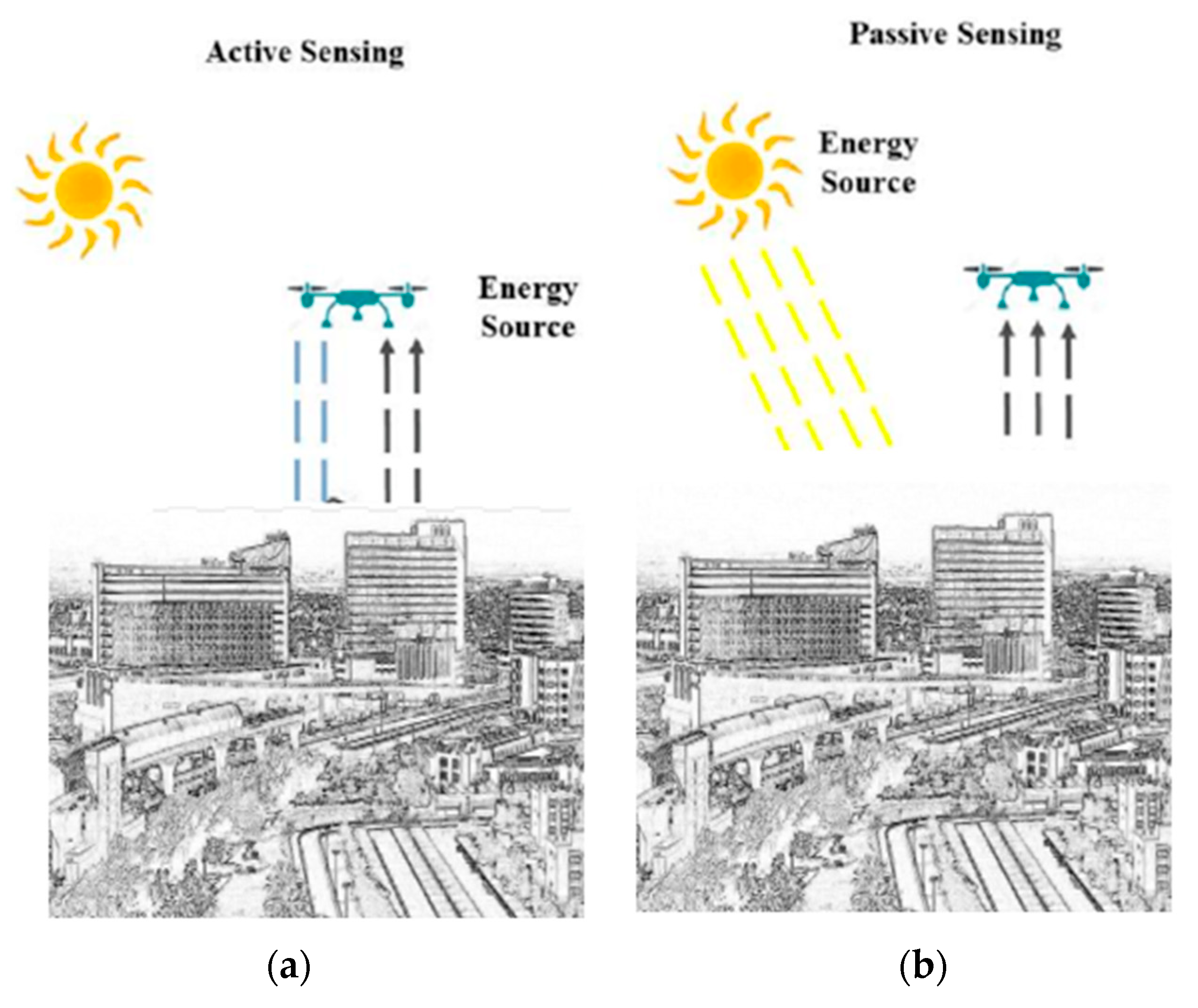
Figure 1. (a) Active remote sensing, (b) passive remote sensing.
Buildings 14 02861 g001
Figure 2. Steps of using remote sensing in construction industry.
Buildings 14 02861 g002
Figure 3. Flowchart of the results.
Buildings 14 02861 g003
Figure 4. Percentages of the platform remote sensing utilized in construction application.
Buildings 14 02861 g004
Figure 5. Sensor types of remote sensing.
Buildings 14 02861 g005
Figure 6. Types of challenges of utilizing remote sensing in construction management.
Buildings 14 02861 g006
Figure 7. Percentage distribution of challenge types.
Buildings 14 02861 g007
Table 1. Name of the journal with the frequency of collected paper.
Name of JournalNumber of Collected Paper
Remote sensing17
Remote sensing environmental12
IEEE5
AUG3
European journal of remote sensing3
International journal of remote sensing2
Table 2. General merits and limitations associated with each platform.
Platform TypesMeritsLimitations References
Satellite-Based Remote SensingLarge Coverage Area
Regular and Systematic Coverage
Multispectral and Hyperspectral Data
Long-Term Data Archives
Takes images of specific locations on a regular and periodic schedule
Spatial Resolution.
Limited Revisit Time
Cost and Accessibility
Atmospheric Effects
[1,23,24,25,26,27,28,29,30,31,32]
Airborne-Based Remote SensingHigh Spatial Resolution
Flexibility and On-Demand Deployment
Enhanced Data Accuracy
Limited Coverage Area
Weather Dependency
Higher Operational Costs
Restricted Flight Regulations
Limits on regularly and periodically taking images of specific locations and user-dependent
[1,25,26,33,34,35,36]
Ground-Based Remote SensingHigh Spatial Resolution
Real-Time Monitoring
Validation and Ground-Truthing
Cost-Effectiveness
Limited Coverage Area
Labor- and Time-Intensive
Accessibility and Permissions
Limited Mobility
[37,38,39]
Table 3. Merits and limitations of remote sensor types.
Remote Sensor TypesMeritsLimitations References
Optical Sensors (Visible, Near-Infrared, and Multispectral)
  • High spatial resolution is available, allowing for detailed mapping and analysis
  • Wide availability of data for various platforms
  • Cost-effective
  • Well-established spectral indices for vegetation monitoring and land cover classification
  • Susceptibility to atmospheric conditions
  • Limited penetration through dense vegetation or cloud cover
  • Inability to capture detailed surface features
  • Reliance on sunlight for illumination
[40,41,42]
Thermal Infrared Sensors
  • Ability to measure and map surface temperatures
  • Capability to detect thermal anomalies
  • Less affected by atmospheric conditions
  • Lower spatial resolution
  • Limited spectral information is available in thermal bands
  • Inability to capture detailed surface features or object identification
[43,44,45,46]
Radar Sensors (SAR—Synthetic Aperture Radar)
  • All-weather and day–night imaging capability due to active microwave sensing
  • Penetration through clouds, vegetation, and some types of terrain
  • High spatial resolution is available in some sensors
  • Ability to measure surface roughness and detect subtle surface deformations.
  • Generally lower spatial resolution comparatively
  • Complex data processing and interpretation
[47,48,49]
Lidar Sensors
  • High spatial resolution allows for precise three-dimensional (3D) terrain, structures, and vegetation mapping
  • Ability to capture detailed elevation information, facilitating topographic analysis and modeling
  • Effective at capturing vertical structure and vegetation height
  • Ability to penetrate forest canopies and provide details
  • Limited availability of data due to fewer satellite-based sensors
  • Higher cost
  • Limited coverage area
  • Sensitive to atmospheric conditions
[50,51,52]
Disclaimer/Publisher’s Note: The statements, opinions and data contained in all publications are solely those of the individual author(s) and contributor(s) and not of MDPI and/or the editor(s). MDPI and/or the editor(s) disclaim responsibility for any injury to people or property resulting from any ideas, methods, instructions or products referred to in the content.