Abstract
Just as Gothic cathedrals have long dominated the perception of medieval architecture, the spectacular drawings of the German lodges have shaped our view of the medieval design process. However, their towering importance has diverted scholarly attention from alternative drafting practices and reinforced the view of a homogeneous Gothic design practice based on quadrature. Historians generally accept that in the 16th century a new Renaissance graphic language challenged and ultimately replaced the Gothic tradition north of the Alps. However, this antagonistic narrative of one dominant practice superseding the other needs to be re-examined because hitherto neglected drawings for other types of buildings reveal that medieval drafting practice was more varied and open to new developments than is often believed. This paper will examine three rare sets of architectural drawings, together consisting of over thirty sheets, made for three stone sluices in the provinces of Utrecht and Holland between 1556 and 1563. They show that for technically demanding hydraulic works, drawings directed every step of the process, from enabling discussion of the most suitable design to guiding the stonemasons in the execution of the work. Moreover, they demonstrate that for such projects, Gothic masters did not adhere to tradition but engaged with new design methods, using scale, colour, and multiple views to convey all aspects of the project, thus indicating that changes in style and method were not always interrelated.
1. Introduction
Just as Gothic cathedrals dominate the perception of medieval architecture, the spectacular drawings of the German masons’ lodges have shaped our view of medieval drafting practices (Böker 2005; Böker et al. 2011, 2013; Bork 2011; Bork 2014). However, their towering importance has diverted scholarly attention from alternative ways of making drawings in the late Middle Ages and reinforced the view of a homogeneous Gothic design practice based on quadrature, which is the use of rotating squares to determine the proportions of the building (Bork 2011). Historians generally accept that a new Renaissance graphic language challenged and ultimately replaced the Gothic tradition north of the Alps in the second half of the 16th century (Bork 2011; Gerritsen 2006; Meischke 1988). This shift is often associated with the spread of the formal language of classical architecture, resting on the assumption that painter–architects had a pioneering role in the development of both architectural style and drawing techniques because master masons and carpenters preferred to stick to their traditions. However, such an antagonistic narrative of one dominant practice superseding the other needs re-examination because drawings for structures other than ecclesiastical buildings reveal that the medieval drafting practice was rather varied and open to new developments (Hurx 2018, 2020, 2023a, 2023b). This was particularly the case in the Low Countries—today’s Belgium and the Netherlands—where new, inventive ways of depicting buildings were introduced in the 16th century, which, in contrast to Italy, did not occur in a humanistic context but resulted from the growing importance of graphic aids in construction. This was in large part due to the increasing involvement of contractors because of the preference to put construction work into tender (Hurx 2018).This practice required more explicit and formal methods of communication than when patrons managed the work themselves because it reduced the amount of control they had over quality. Therefore, it necessitated more detailed descriptions of the work and legal documentation of builders’ responsibilities. Consequently, drawings and written documents were increasingly important as a means to communicate designs and guide the construction process.1
While the importance of drawings is corroborated by contemporary sources, the want of preserved architectural drawings before the late 16th century presents something of a paradox: if drawings were such crucial planning instruments, why are so few preserved? This issue is not unique to the Low Countries, as in many regions in Europe (including Italy), relatively few drawings from the building process survived from this period. Historians have long questioned the consequence of drawing in the making of architecture before the Renaissance. The study of the rich corpus of drawings that remains for the German masons’ lodges, which goes into hundreds of drawings by Hans Böker, has demonstrated that Gothic master masons were indeed prolific draftsmen (Böker 2005; Böker et al. 2011, 2013). His work is complemented by a recent inventory of drawings in Spanish archives by Javier Ibañez Fernández, which has also unearthed a vast number of architectural drawings, showing that the production of architectural drawings was common practice before 1600 (Ibáñez Fernández 2019. See also the article by Ibáñez Fernández in this special issue). Nevertheless, it is notable that projects from up to the 16th century are typically preserved only as plans or elevations and often do not depict the building in its entirety. In rarer cases, the elevation was matched with a partial plan, sometimes of superimposed planes showing the building at different levels. Examples of buildings documented with a full set of drawings, as is standard in our modern architectural practice, hardly exist.
This paper explores a neglected category of drawings for hydraulic works, particularly locks and sluices, offering fresh insights into developments in Netherlandish design practices during the 16th century. Civil engineering structures are rarely considered by architectural historians as they do not belong to the traditional remit of the discipline. Yet prominent masters were involved in their planning. Because they were technically demanding, hydraulic works presented tough design challenges and required careful preparation. They were often built in difficult conditions, in water, and frequently on muddy ground (Hurx 2022). Moreover, they had to be durable, as failure could cause disaster and lead to serious water management problems or the long-term disruption of shipping traffic. This paper considers three case studies of drawings for two locks and a sluice in the Provinces of Holland and Utrecht, which have gone largely unnoticed in architectural history. The first one, for the Vaartse Rijn in Utrecht, shows that drawings and three-dimensional models were vital tools for obtaining the latest insights into sluice building, while the second at Alphen aan den Rijn in Holland reveals that drawings were imperative in discussing alternative designs. The third case of a stone sluice in Holland at Halfweg will be analysed in more depth, as the exceptional set of 19 drawings provides an unprecedented insight into the consequence of drawings to the mid-16th-century design and building process. Furthermore, the context in which they were made can be understood from the accounts and minutes of the meetings of the water board, which have been preserved almost in their entirety and are supplemented by a considerable number of original supporting documents, such as letters, estimates, contracts, construction specifications, and receipts. It demonstrates that graphic aids directed virtually all steps in the process, from enabling discussion on the most suitable design to guiding the stonemasons in the execution of the work. In addition to shedding light on 16th-century drafting practices, this paper highlights a significant yet largely forgotten generation of architects in the Low Countries who worked roughly between 1540 and 1560, a transitional period from late Gothic architecture to the emerging Renaissance style.
2. Gothic Masters in the Renaissance
In the Low Countries, the first generation of full-scale buildings in the Renaissance idiom, or all’antica manner, as it was referred to in contemporary sources, dates from the 1530s (De Jonge 2007). With Antwerp as its main hub, the Netherlandish interpretation of antique vocabulary,—especially through the work of Cornelis II Floris—had a profound influence on the rest of Northern Europe from the 1550s onward (Ottenheym and De Jonge 2013). However, the Renaissance style did not immediately replace the Gothic style, nor did it disrupt the advanced structure of the building industry (Hurx 2018, pp. 366–75). Rather, both styles continued to exist side by side up to the 1550s, with Gothic architecture being referred to as the “modern manner” (as opposed to the “antique manner”). In the literature, designers who specialised in either the Gothic or Renaissance style have received more attention than the generation of masters active between 1540 and 1560. These masters were trained in the late Gothic tradition but often also created designs in the antique manner. They are overshadowed in historiography by their forebears, notably the great Gothic designers Rombout Keldermans (d. 1531), Dominicus De Waghemakere (d. 1542), and Lodewijk van Boghem (d. 1541), who created many of the monumental and extraordinary richly decorated late-Gothic buildings in the service of the church, cities, and nobility —e.g., the tower of Our Lady in Antwerp, Ghent Town Hall or the church of Saint-Nicolas-de-Tolentino in Brou. In the same vein, the masters of this “transitional generation” are eclipsed in the literature by their contemporaries such as Jacques Du Broeucq (d. 1584) and Cornelis II Floris (d. 1575), both of whom were pivotal in the reception of Renaissance architecture in the Low Countries. Contrary to the traditional art historical narrative, this forgotten group of master masons did not stubbornly cling to the past; instead, they were recognised by contemporaries as experts. Furthermore, they were receptive to new architectural developments. For instance, Philip Lammekens (d. 1548), who was master of the works of Our Lady in Antwerp, received major commissions for structures in both styles (Hurx 2018; Duverger 1964). And the court’s Master Mason of Brabant, Anthonis Mockaert, who designed the princely meat hall of Brussels in 1565, was praised by Hans Vredeman de Vries in his 1577 treatise ARCHITECTURA in the same breath as Du Broeucq and Cornelis II Floris for being “wise and ingenious masters/daring architects of these Low Countries” (…cloecke ende Ingenieuse Meesters/onvervaren Architecteurs deser Nederlanden…). Vredeman championed them for accommodating antique models to the “necessities and customs of this country” (Ottenheym and De Jonge 2007, pp. 93–96).2
The designers of the two locks and the sluice discussed in this article were also prominent master craftsmen: the lock at Utrecht was designed by the city architect of Utrecht, Heinric van Noort, while the two designs of the lock at Alphen aan den Rijn were made by the city architect of Amsterdam, Reynier Corneliszn, and the master carpenter of Saint-John’s in Gouda, Cornelis Fredericksz van Montfoort. The sluice at Halfweg was devised by his direct colleague, the master of the works at the same church, Cornelis Fredericxz van der Goude. Van Noort followed in his father’s footsteps, Willem van Noort, in 1556 as city architect of Utrecht (stadt architekt) (Dodt van Flensburg 1843, vol. 3, p. 230). In this capacity, he was responsible for the supervision of the works undertaken by the city, ranging from new projects to mere maintenance work. While not very much is known about his career, he is, like his father, documented to have made designs in the antique manner. For instance, he was paid retrospectively in 1577 for a drawing of one of the city gates, called the Tolsteegpoort (Dodt van Flensburg 1843, vol. 3, p. 249).3 This gate, which was built around 1557–59, had doric pilasters and rustica bands. Of the other three masters, relatively little known as well, and no designs in the antique manner are recorded. Cornelis Fredericxz van der Goude was clearly in high demand, being involved in several building projects of different natures throughout the region. In 1546, he was recognised by the Court of Holland as “one of the best masters in this art” (of making sluices).4 The study of their design practice reveals that they were also early adapters in taking on new design methods, using scale, colour, and multiple views to convey multiple aspects of the project, as well as making early use of three-dimensional architectural models.
3. The Consequence of Architectural Drawings in the Low Countries
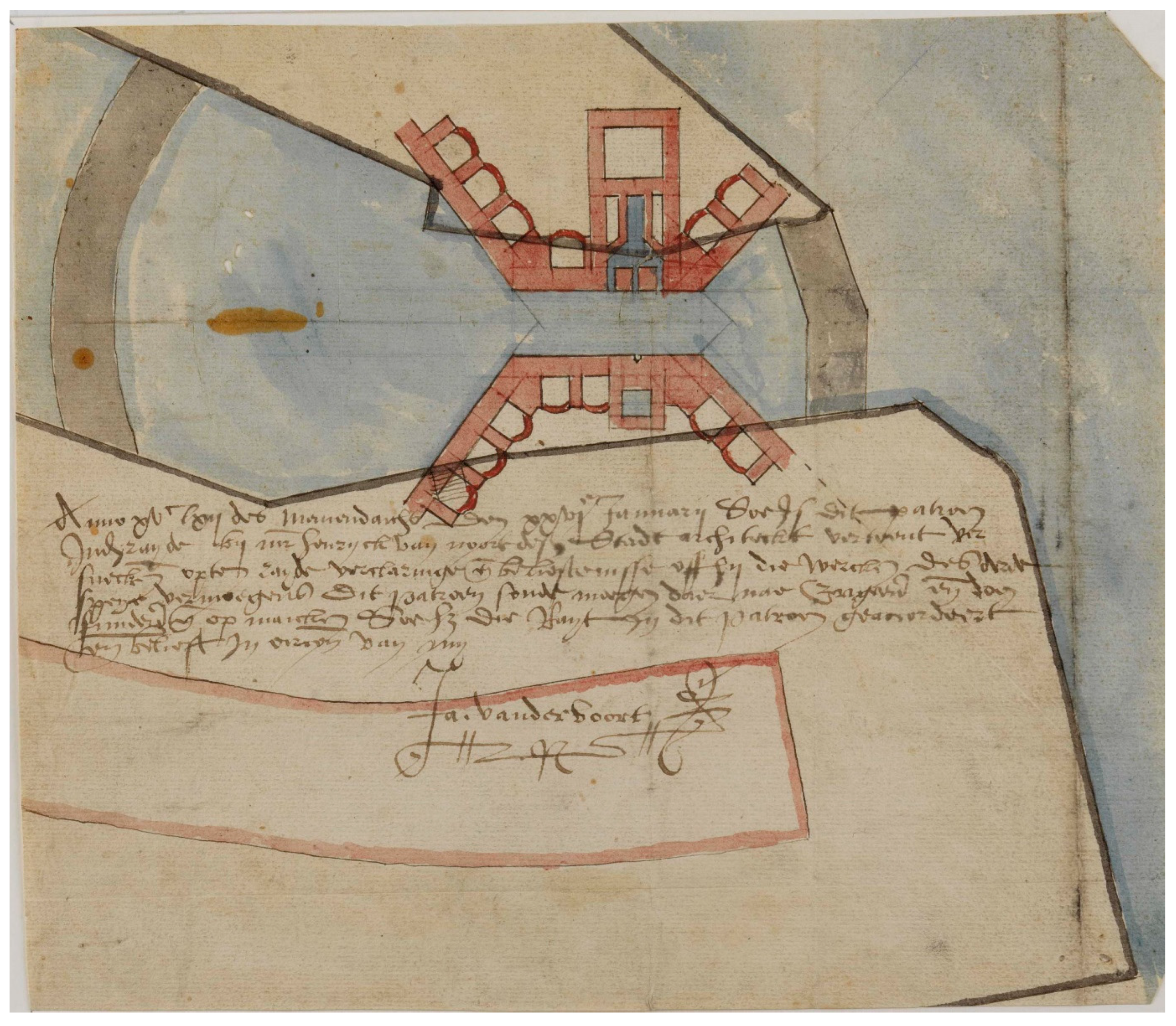
One way to approach the paradox of the lack of medieval drawings is to turn to archival references. Building accounts in the Low Countries contain many payments for drawings, which are usually called beworp or patroen (“pattern”) in Dutch or patron in French (Hurx 2018, pp. 241–44; Meischke 1988, pp. 140, 165–67). Several surviving drawings bear a note identifying them as a “pattern”. For instance, the second design for the lock at the Vaartse Rijn, several kilometres south of Utrecht—to be discussed below—made in 1562 by Heinric van Noort is indicated by the note as a patron (Figure 1). The first design by Van Noort, made a year earlier, in 1561, shows an alternative ground plan and uses different words to refer to it: chaerte, meaning “map”, and grontwerck, which can be literally translated as “groundwork”, or ground plan. A difficulty in interpreting written records is that such terms were used interchangeably to refer to designs in general, including drawings, stonecutters’ templates, and three-dimensional objects. Sometimes words such as beworp referred to written specifications, although the term generally used for such a document was bestek or ordonnantie (Hurx 2018, pp. 241–44). Another issue is that references to drawings only show up in the accounts when the maker was paid for them separately. Often, their production was included in the lump sum of contracted work or was covered by the allowance, usually called a pension, paid to a master craftsman or architect by his patron, which means that, frequently, only the exceptions are recorded.
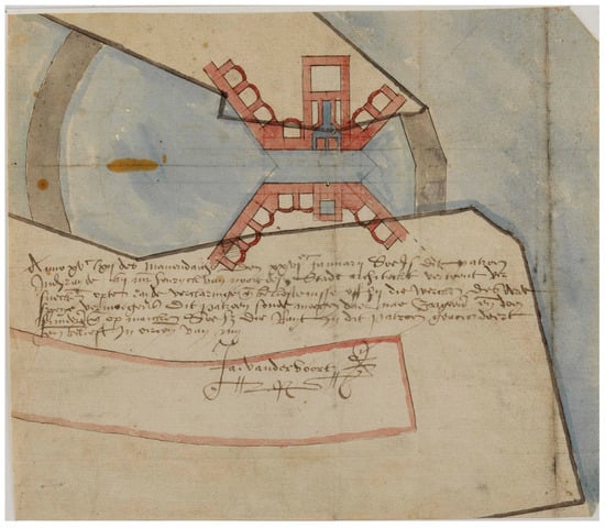
Figure 1.
Heinric van Noort, second design for the new lock for the Vaartse Rijn at Vreeswijk (near Utrecht), 1562, Utrechts Archief, Topografische Atlas, collectie Muller 1013, 5 (© Utrechts archief).
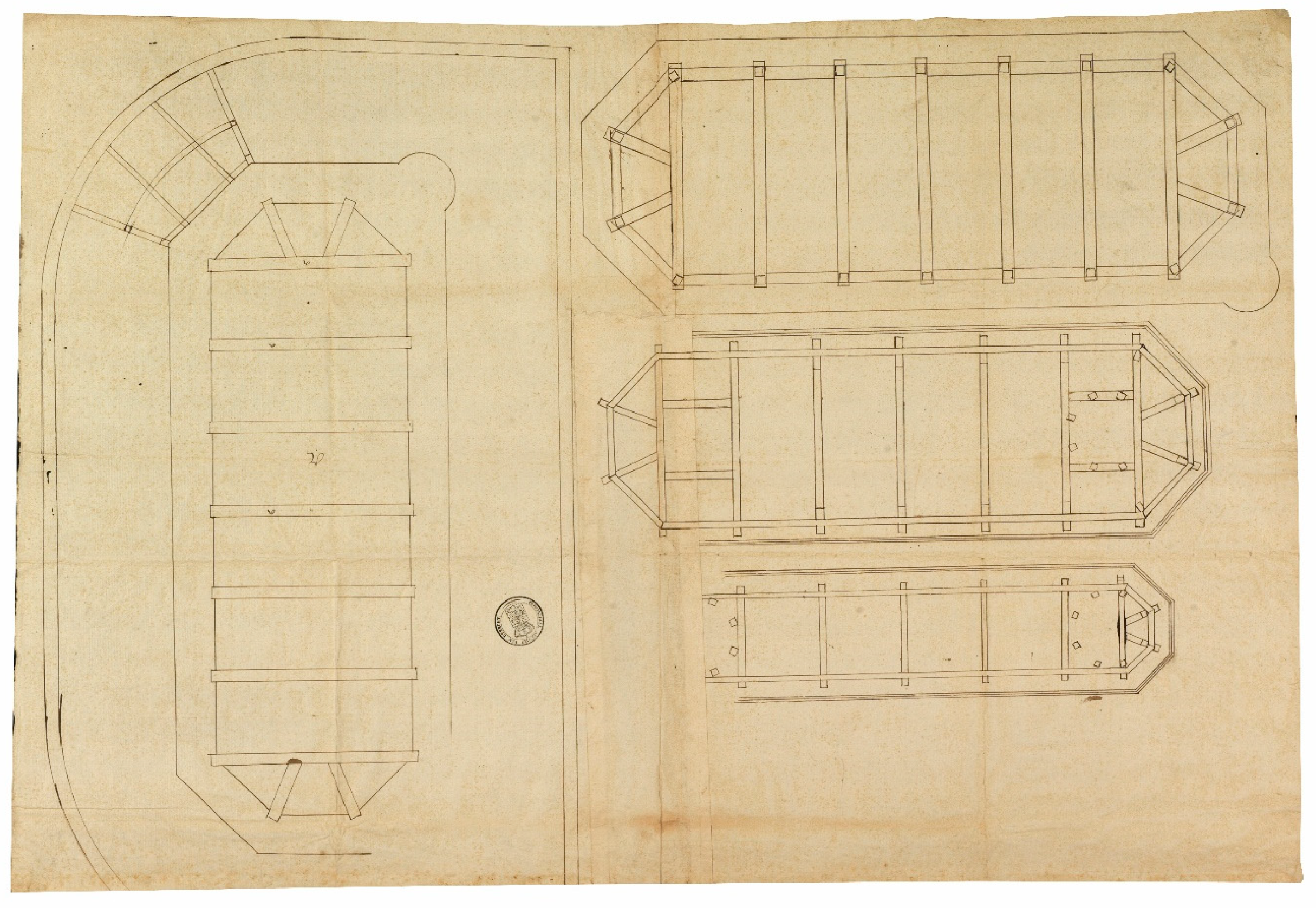
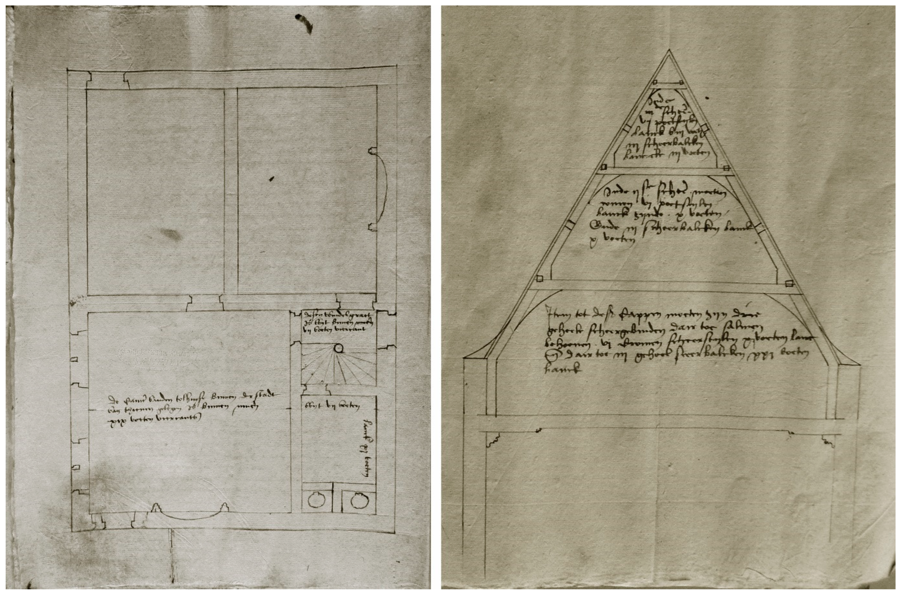
There are other historical accounts that provide an explicit acknowledgement of the key role of drawings in medieval practice in the Low Countries. One is a testimony in a court case in Utrecht in 1542 on guild regulations between a stonecutter and Heinric’s father, Willem van Noort, the city mason of Utrecht.5 I have discussed the details of this case elsewhere; what is important here is that multiple witnesses were asked questions about the making of architectural designs (Hurx 2018, pp. 42–44). Philip Lammekens, who was one of them, testified that without drawings (beworp oft patroon), no building could ever be erected.6 This contrasts sharply with the number of surviving drawings made before 1540 in the Low Countries, which is just over 30 (Hurx 2018). Most of them are presentation drawings that provide an attractive view of a project, usually meant to serve the discussion with the patron. Importantly, such drawings commonly lack the detailed information needed to communicate the design to the builders. Furthermore, usually, no more than a few drawings survive for a single project, making a full three-dimensional understanding difficult.7 One explanation for this in architectural history is that medieval builders did not need a full set of drawings because they understood the geometrical logic of the design, which could be replicated at the building yard and allowed building experts to understand the elevation from the plan (Gerbino and Johnston 2009, p. 24; Pacey 2007, pp. 59–65; Ackerman 2002, p. 31; Hecht 1979, pp. 381–82). This technique of “pulling out” the elevation from the plan was called Auszug in Germany and is best described for the design of pinnacles in Matthaüs Roriczer’s Büchlein van der Fialen Gerechtigkeit (Bork 2011, pp. 6–7; Lefèvre 2004; Coenen 1990; Shelby 1977, pp. 61–79). For the German masons’ lodges, examples of plans with superimposed planes abound, and while this drafting technique was certainly known in the Low Countries, other ways to convey the spatial arrangement of a building were preferred (Hurx 2018, p. 288; De Jonge 2014). An early instance is a drawing of the roof structure of the large corner towers of Vredenburg Castle in Utrecht made in 1532 (Figure 2). The draftsman, possibly Laureys Keldermans, the nephew of Rombout Keldermans, chose to show the construction in four uniform horizontal layers represented at the same scale and placed next to each other (Hurx 2023a, pp. 70–74, Hurx 2018, p. 289). Also, combinations of the plan and elevation existed. An early example is provided by three drawings that illustrate the building specifications for a renovation of the ducal toll house in Tienen made in 1546 by Pieter van Wyenhoven and Wouter de Cock, the court’s Master Mason and the Master Carpenter of Brabant. The lengthy text describes the work and is complemented by a floor plan, a plan of the beams supporting the first floor, and a section of a roof truss drawn to the same scale (Figure 3) (Hurx 2023a, p. 74).
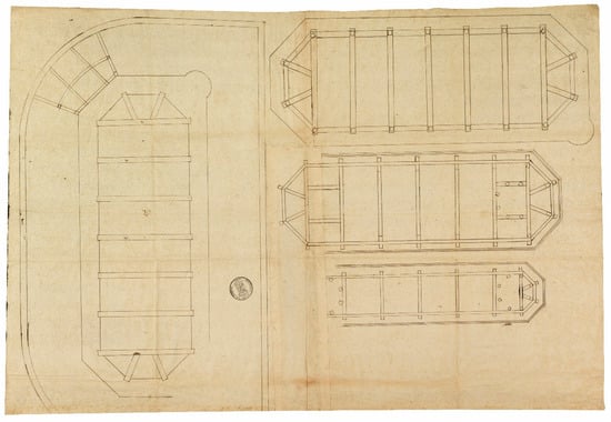
Figure 2.
Laureys Keldermans (attributed), drawing of the roof construction of the large corner towers on the field side of Vredenburg Castle in Utrecht, 1532, Het Utrechts Archief, 37 Financiële Instellingen, 46-3 (© Het Utrechts Archief).
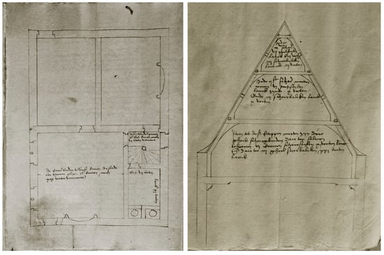
Figure 3.
Pieter van Wyenhoven and Wouter de Cock, illustrated building specifications for the renovation of the toll house of Tienen with annotated floor plan and section of the roof structure, 1546, Archives générales du Royaume, Brussels, Chambre des Comptes, Cartons, 131/1 (© author).
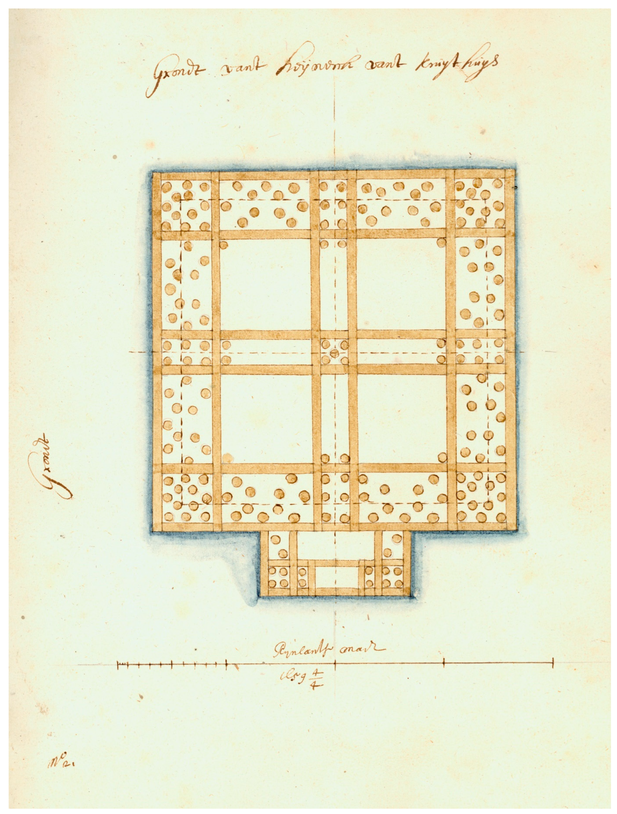
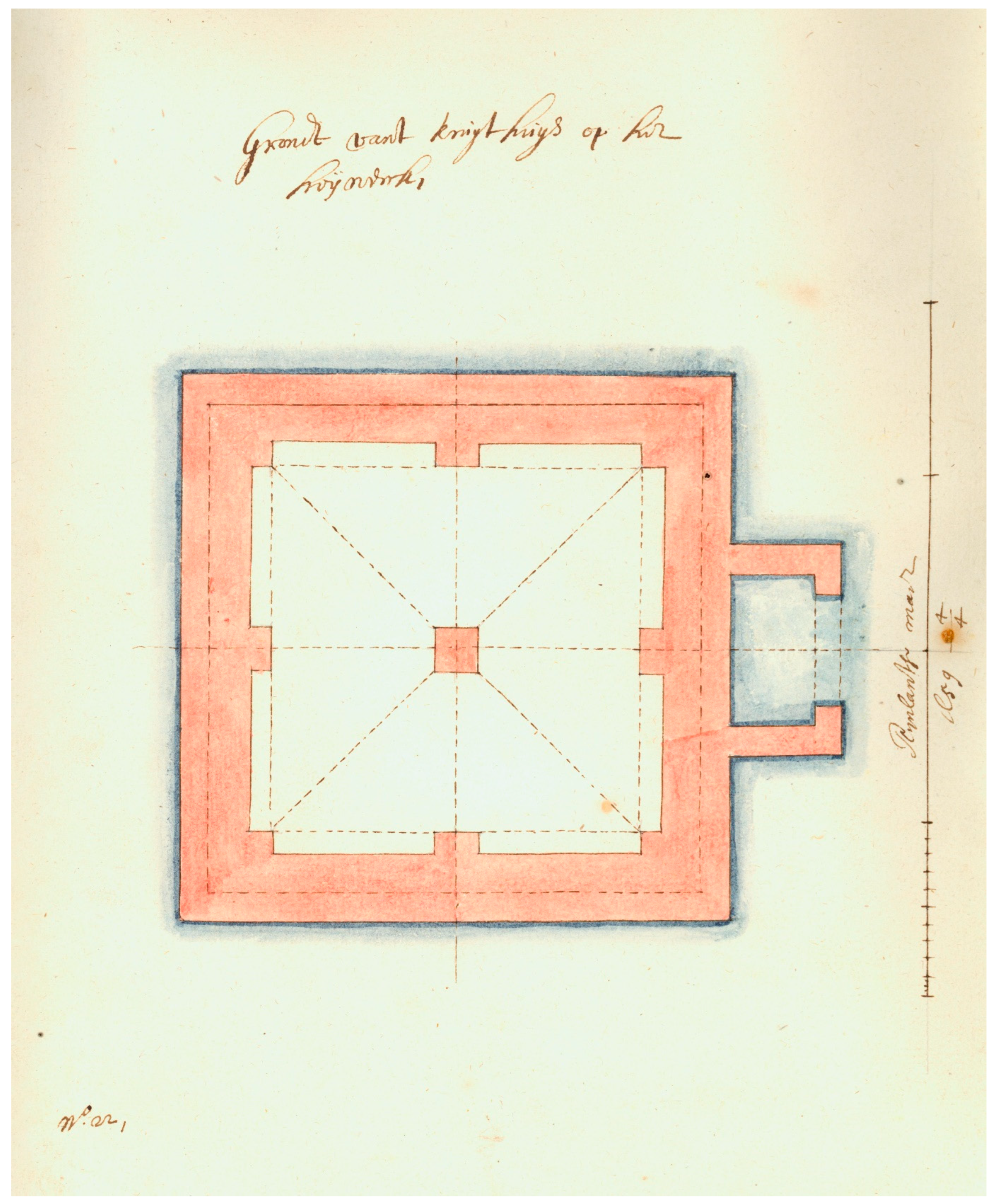
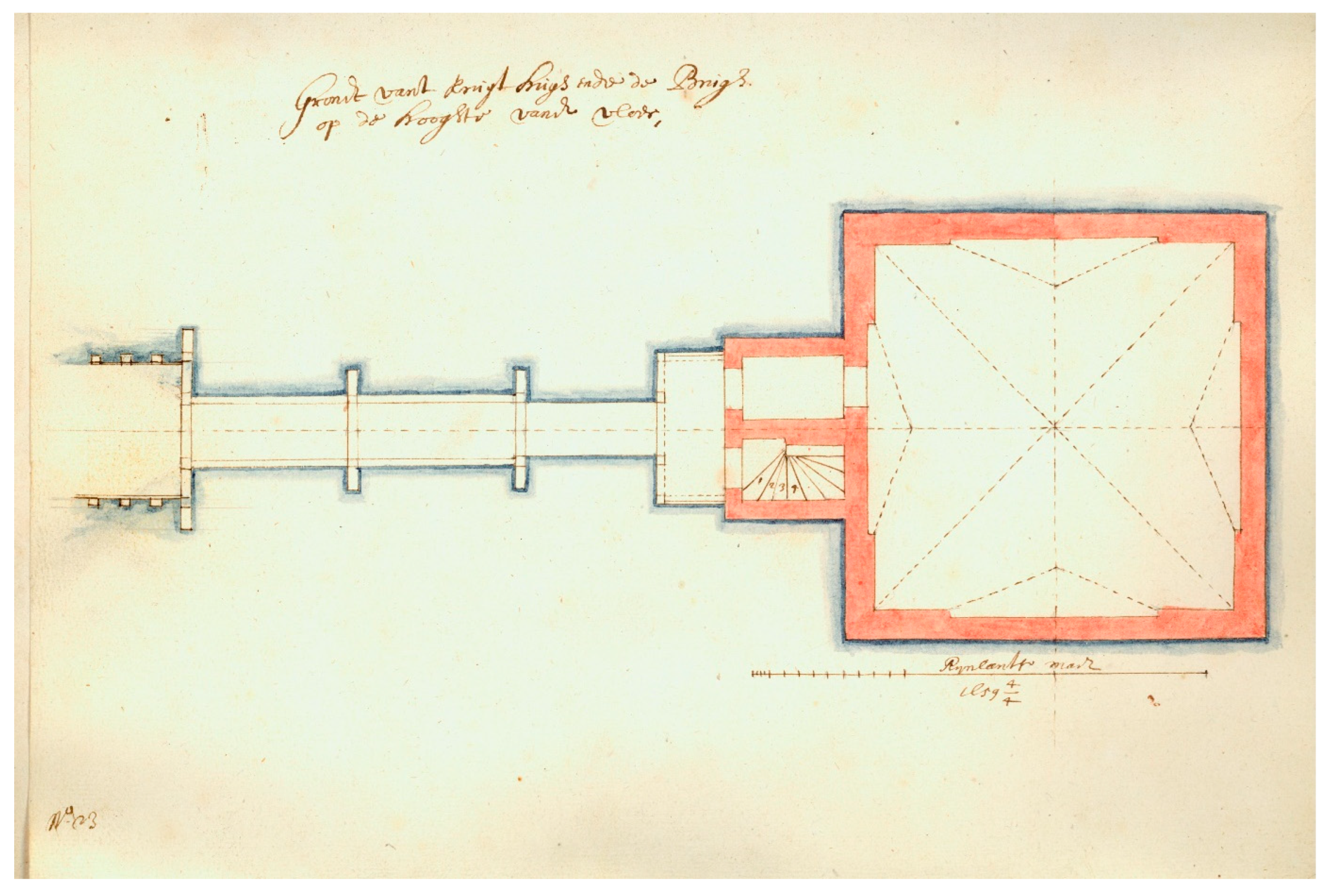
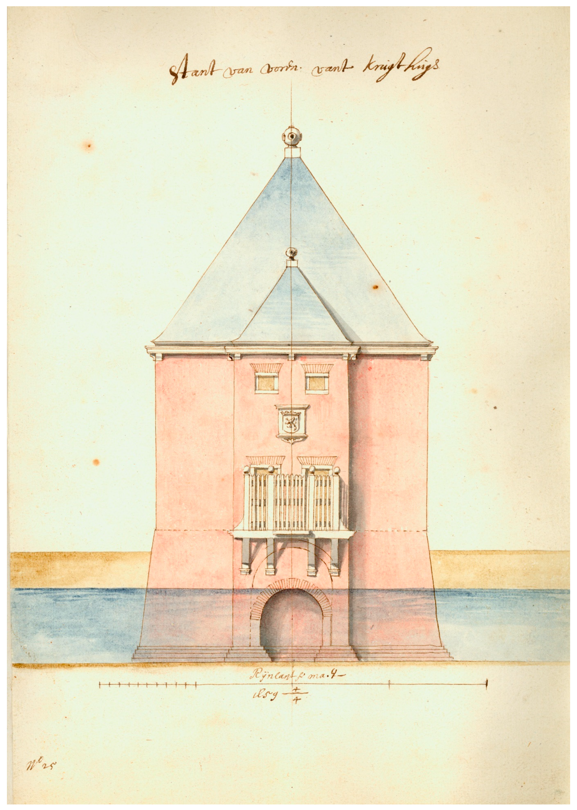
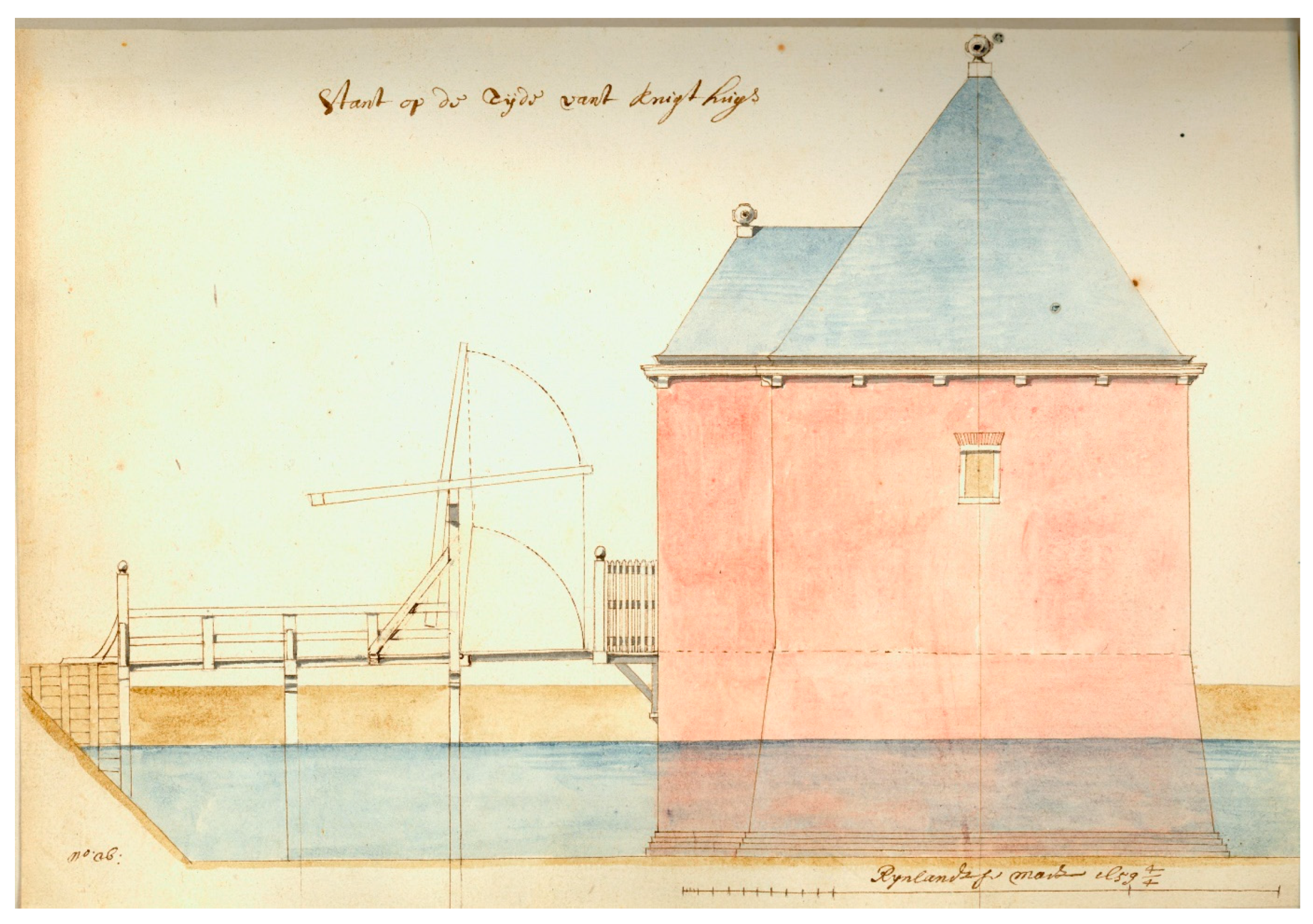
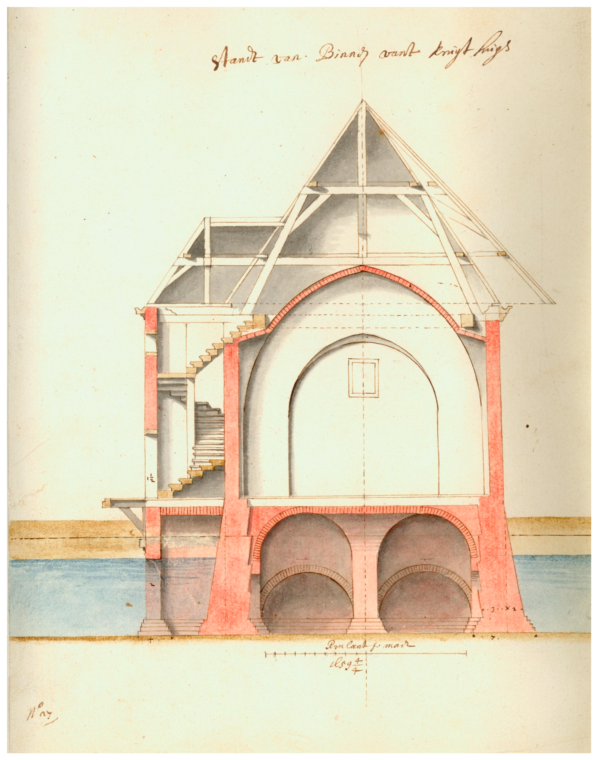
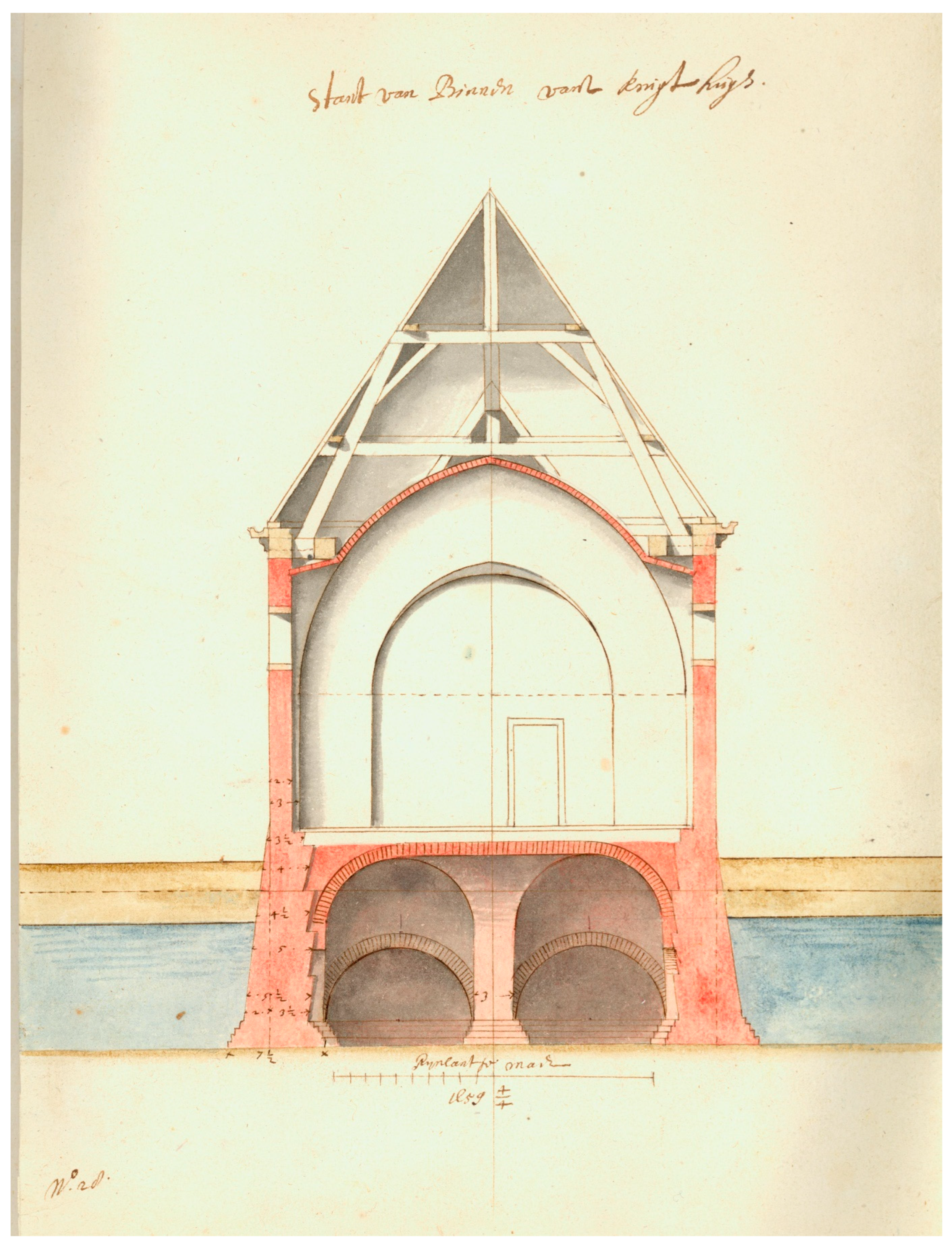
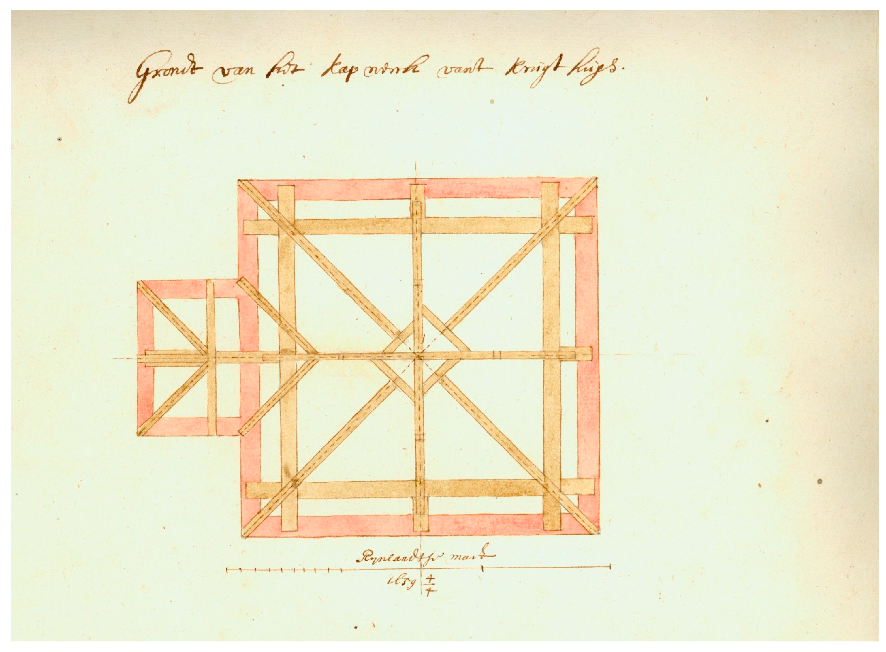
The lack of complete sets of drawings is not something specific to the Middle Ages. In fact, the number of surviving drawings does not increase significantly until the beginning of the 17th century (Gerritsen 2006). The earliest preserved examples in the Low Countries to depict the building in a comprehensive way, including technical details, date from around the middle of the 17th century. The most complete example is a set of drawings by the classicist painter–architect Pieter Post for the Kruithuis at the waterway the Delftse Schie several kilometres south of the town of Delft. This storage for gunpowder of the States General was constructed between 1659 and 1662, several years after the Delft Explosion in 1654, when the explosion of a gunpowder store left a large part of the city in ruins. Post’s earliest drawings for the project are lost, but 31 are kept together in a booklet made in spring 1659 (Pieter Post, Kruithuisboek, Stadsarchief Delft, 122,087. (https://hdl.handle.net/21.12115/NL-DtAD212048436, accessed on 21 September 2024). They include a general plan of the site, which shows a gatehouse, a guardhouse, a storehouse, and two powder houses. For each of these structures, plans at multiple levels, longitudinal and transverse sections, and elevations from multiple sides were drawn (Figure 4, Figure 5, Figure 6, Figure 7, Figure 8, Figure 9, Figure 10 and Figure 11). They were supplemented with technical drawings for the foundations and a plan of the roof structure of one of the powder houses, as well as a drawing for the mantelpiece of the gatehouse (Gerritsen 2006, pp. 114–20). The drawings were made during the planning phase as alternative solutions were depicted. After the final design was selected, Post was asked to prepare written specifications for the execution. His drawings show that few details were left to the imagination of the builders. A similarly extensive set of drawings made by Post between 1639 and 1655 is preserved for the country house of Vredenburg in Beemster (North Holland). He is also known to have made 50 drawings for the Weighhouse in Leiden. However only two survive (Gerritsen 2006, pp. 98–105). Post’s examples suggest that by this period, it was not uncommon to prepare a complete set of drawings for a new building.
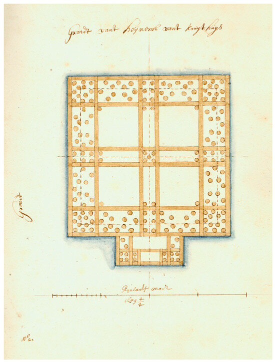
Figure 4.
Pieter Post, plan for the foundations of the powder house for the Kruithuis near Delft (Grondt vant Heijwerck vant Kruythuys), 1659, Stadsarchief Delft, obj. nr. 7888 (© Stadsarchief Delft).
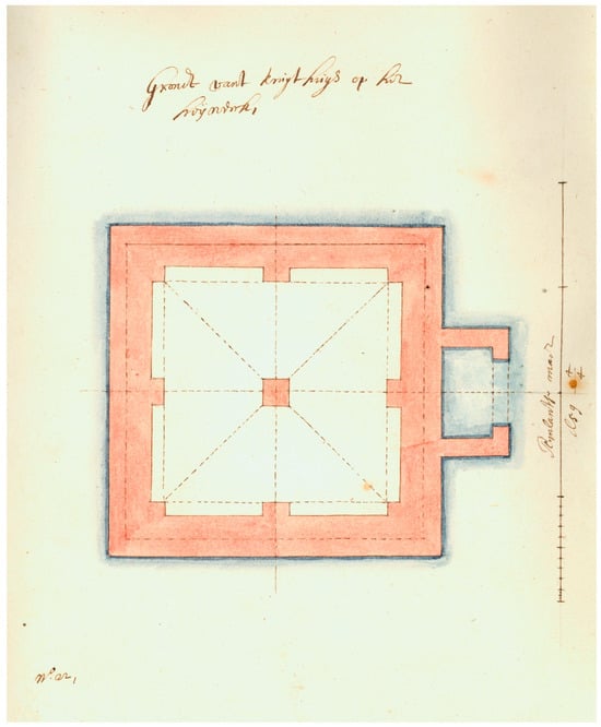
Figure 5.
Pieter Post, plan of the powder house at the level of the basement for the Kruithuis (Grondt vant kruythuys op het heijwerck), 1659, Stadsarchief Delft, beeldcollectie, obj. nr. 7889 (© Stadsarchief Delft).
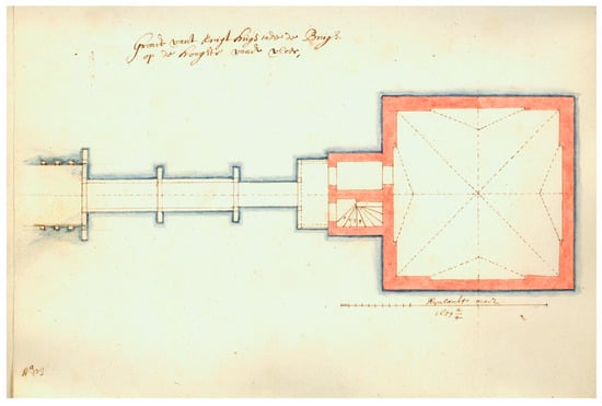
Figure 6.
Pieter Post, plan of the powder house with the bridge at floor level for the Kruithuis (Grondt vant Kruythuys ende de Brugh op de hooghte vande vloer), 1659, Stadsarchief Delft, beeldcollectie, obj. nr. 7890 (© Stadsarchief Delft).
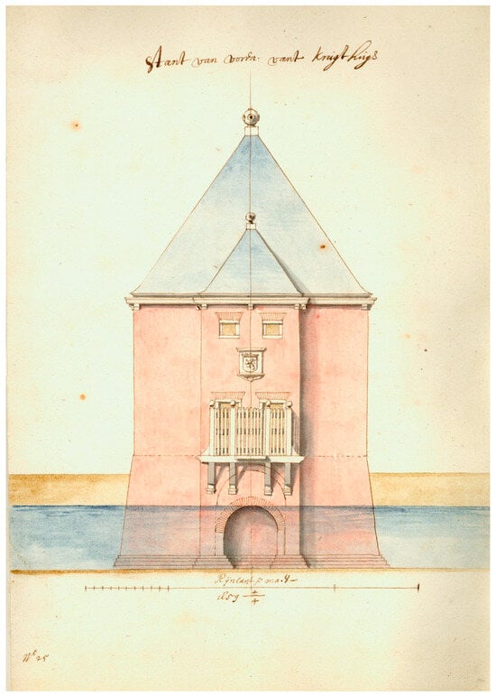
Figure 7.
Pieter Post, elevation of the front of the powder house for the Kruithuis (stant van voren vant kruythuys), 1659, Stadsarchief Delft, beeldcollectie, obj. nr. 7892 (© Stadsarchief Delft).
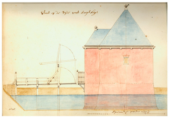
Figure 8.
Pieter Post, elevation of the side of the powder house for the Kruithuis (stant op de zijde vant kruythuys), 1659, Stadsarchief Delft, beeldcollectie, obj. nr. 7893 (© Stadsarchief Delft).
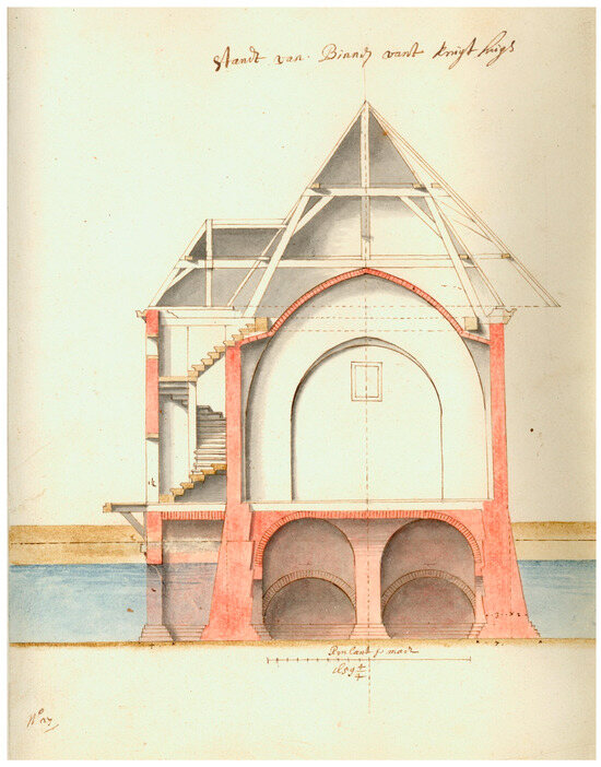
Figure 9.
Pieter Post, longitudinal section of the powder house for the Kruithuis (standt van Binnen vant kruythuys), 1659, Stadsarchief Delft, beeldcollectie, obj. nr. 7894 (© Stadsarchief Delft).
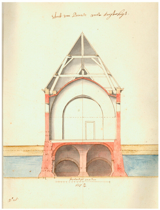
Figure 10.
Pieter Post, transversal section of the powder house for the Kruithuis (standt van Binnen vant kruythuys), 1659, Stadsarchief Delft, beeldcollectie, obj. nr. 7895 (© Stadsarchief Delft).
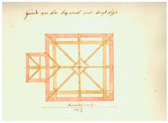
Figure 11.
Pieter Post, plan of the roof structure of the powder house for the Kruithuis (Grondt van het kapwerck vant kruythuys) 1659, Stadsarchief Delft, beeldcollectie, obj. nr. 7891 (© Stadsarchief Delft).
4. Drawings and Models for Stone Locks
While fire proved to be disastrous in Delft, the threat of water is even more omnipresent in the history of waterlogged Holland. Hydraulic works such as dikes, harbours, locks, and sluices were essential in the battle against water. The planning of these structures required great care, and it is, therefore, not surprising that large numbers of drawings survive for such works from the 16th century onwards. The distinction between the terms “lock” and “sluice” is somewhat confusing. Today, the term (pound) lock is commonly used for structures that allow vessels to pass, while sluice is applied to structures used for drainage purposes. However, in Dutch, a “sluis” can serve both purposes, although there exist different terms such as “spui” and “schutsluis” or “duikersluis” to distinguish between their different functions. This overlap in terminology also existed in English historical records up to the 17th century (Chisholm 2005). In this paper, the term “sluice” is used both for a channel with a gate used for drainage and for devices used for raising and lowering watercraft, while its coordinate term “lock” designates the latter only.
In the 16th century, sluice design experienced several innovations, including the introduction of new types of sluice gates and the application of more durable materials, such as stone and brick (Van Dam 2002). Medieval sluices were usually timbered, and while the first masonry examples had been constructed in Flanders already in the 14th century, masonry locks servicing larger ships became more common around 1550 (Van Dam 2002; Arends 1994). Developments were largely prompted by external factors. Improved designs were essential to accommodate increased traffic in combination with larger vessels, as well as to face an ecological crisis due to subsiding peatlands and the silting up of harbours, which required better water management (Van Dam 2002). In addition, sluices became used for military inundations, which was a typical defensive strategy in the 17th century in the Dutch Republic (Klinkert 2007).
The construction of new sluices involved multiple experts and usually included the extensive study of existing structures, often across a large geographic area. In this process, drawings and three-dimensional models were essential tools as is revealed by archival records of the construction of a series of masonry locks in the Vaartse Rijn near Utrecht. Between 1560 and 1562, Heinric van Noort and the city carpenter, Berent Stevensz, made multiple study trips to various locks in Holland, Flanders, and Brabant. During their visits they collected drawings of the latest designs. In 1560, Van Noort obtained a number of drawings of several locks and sluices (speyen en sluysen) in the city of Gouda (Dodt van Flensburg 1843, vol. 3, p. 234). After a couple of weeks, they returned from Antwerp with a wooden scale model of a lock with a moveable gate, which was discussed by the city council (Hurx and Ottenheym 2015; Dodt van Flensburg 1843, vol. 3, pp. 233–34). Two years later they visited new locks in the just-completed Willebroek Canal that connected Brussels with the Scheldt River, spending 5 days there and discussing the designs with the architect and master craftsmen. They took several drawings back to Utrecht as the materialised outcome of the composite visions of their research trips. These provided essential input for the production of a wooden model for the new lock in Utrecht that was made on their return (Hurx and Ottenheym 2015; Dodt van Flensburg 1843, vol. 3, pp. 234–35). It is notable that for this project, at least two wooden models were made. Three-dimensional models were still uncommon in the 16th century, and the planning of locks may even have propelled their use in architectural practice.
The two remaining drawings (Figure 1 and Figure 12), already mentioned above, show the lock in plan together with its immediate surroundings: the river Lek, which is a branch of the river Rhine, is depicted on the right, while the Vaartse Rijn, the canal to Utrecht, is on the left. On both drawings, dotted lines indicate the temporary dams necessary to create the building pit. Special attention is paid to the sluice gates and the way the masonry connects by means of buttresses with the main body of the river dike. The two designs differ in two respects: the first drawing from 1561 (Figure 12) shows a plan with two doors that slide horizontally, while the second one from 1562 (Figure 1) has only one door of a similar type. The second difference is that the second drawing depicts arches, shown here in section, that connect the buttresses: these are vaulted arches that were to reinforce the masonry.
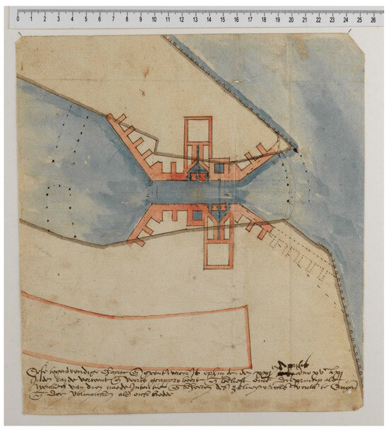
Figure 12.
Heinric van Noort, first design for the new lock for the Vaartse Rijn at Vreeswijk (near Utrecht), 1561, Utrechts Archief, Topografische Atlas, collectie Muller 1013, 5 (© Utrechts archief).
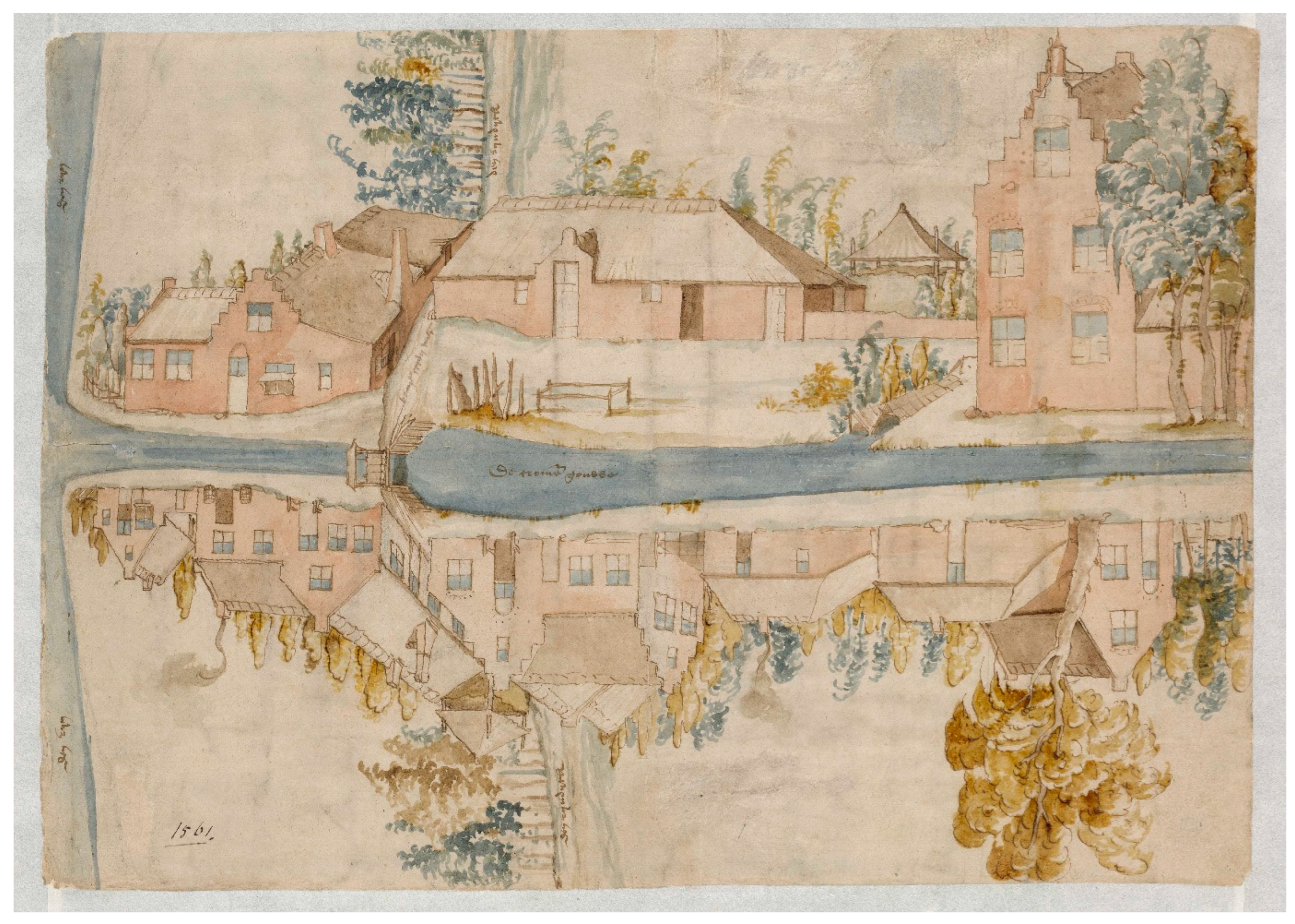
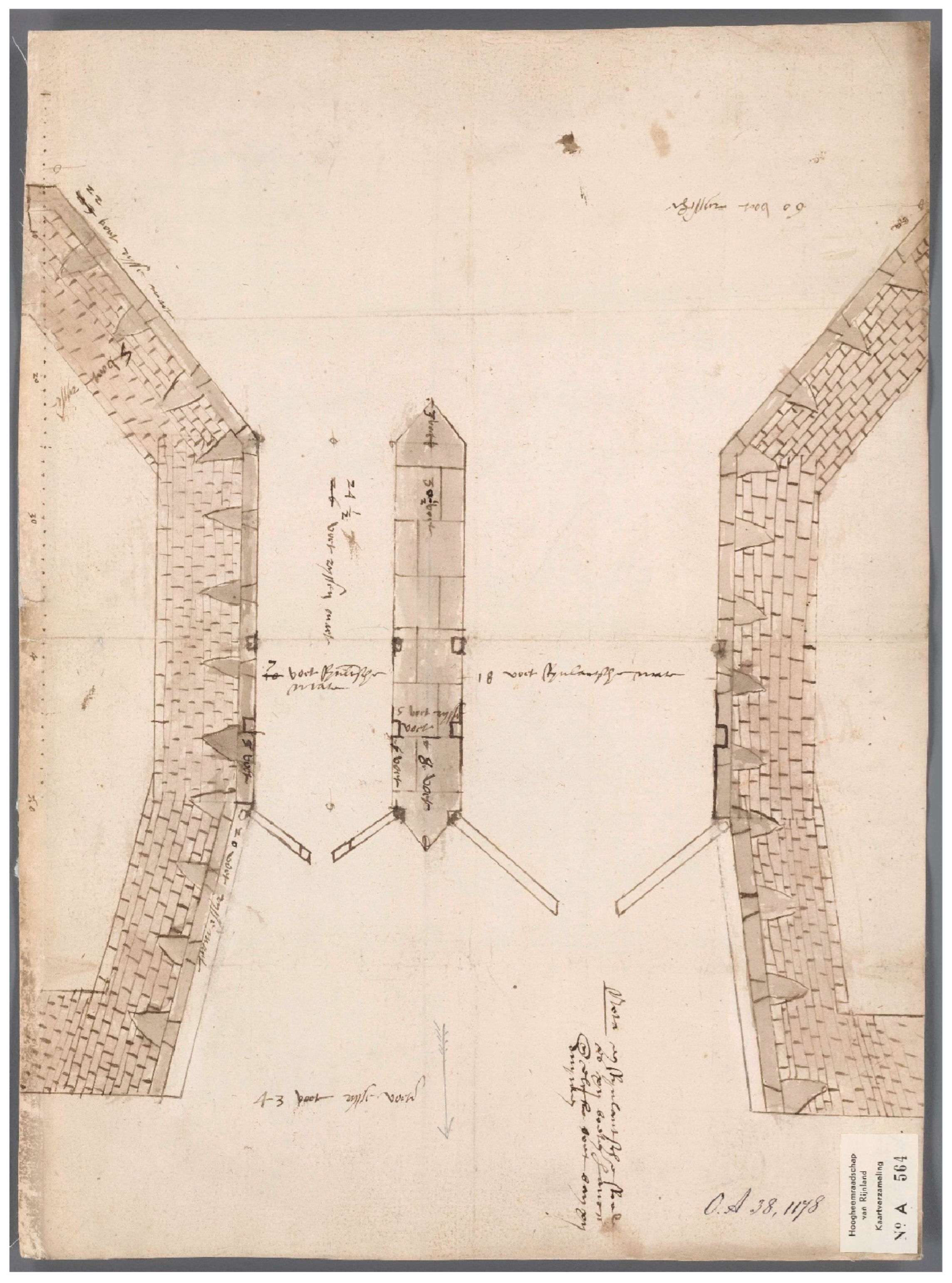
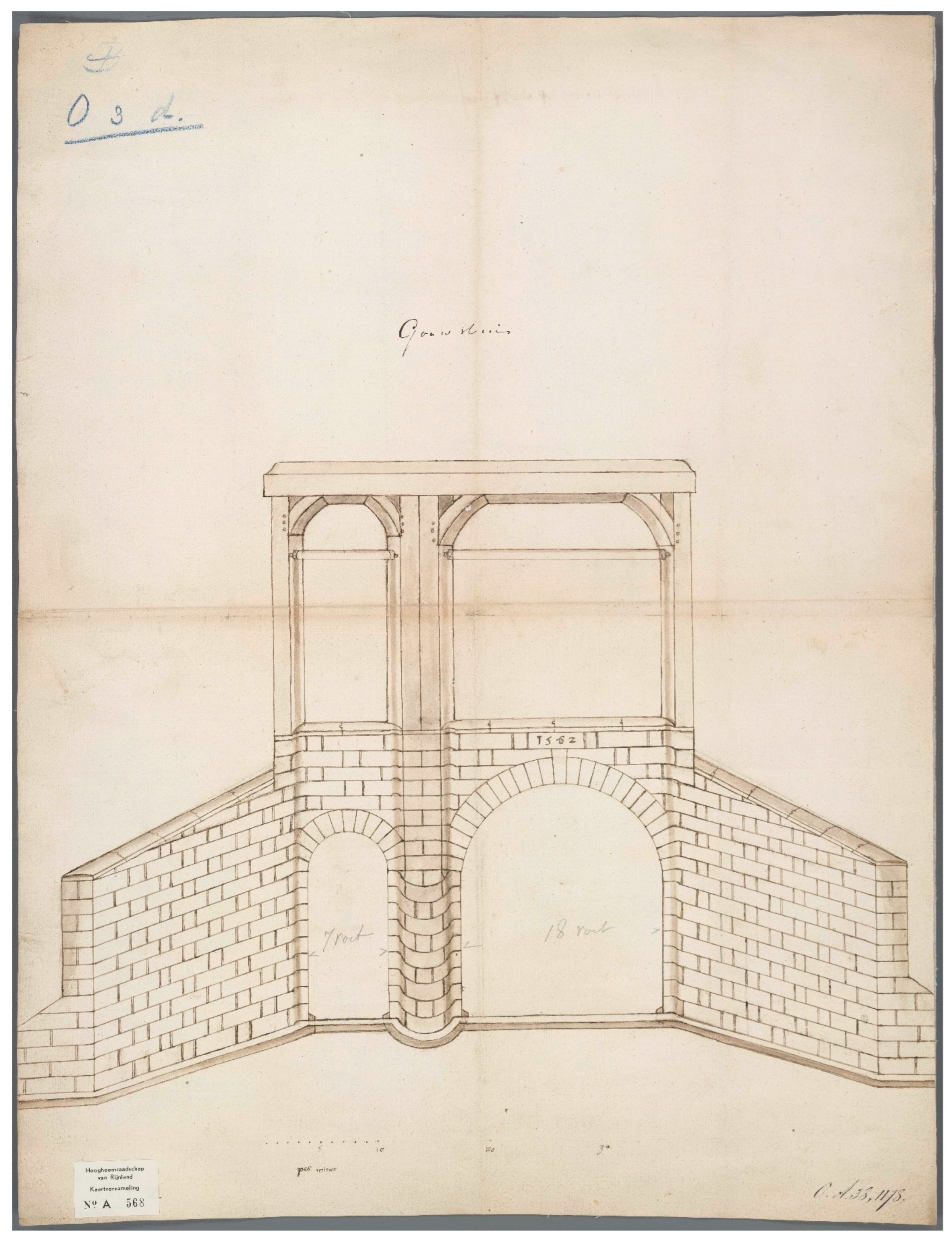
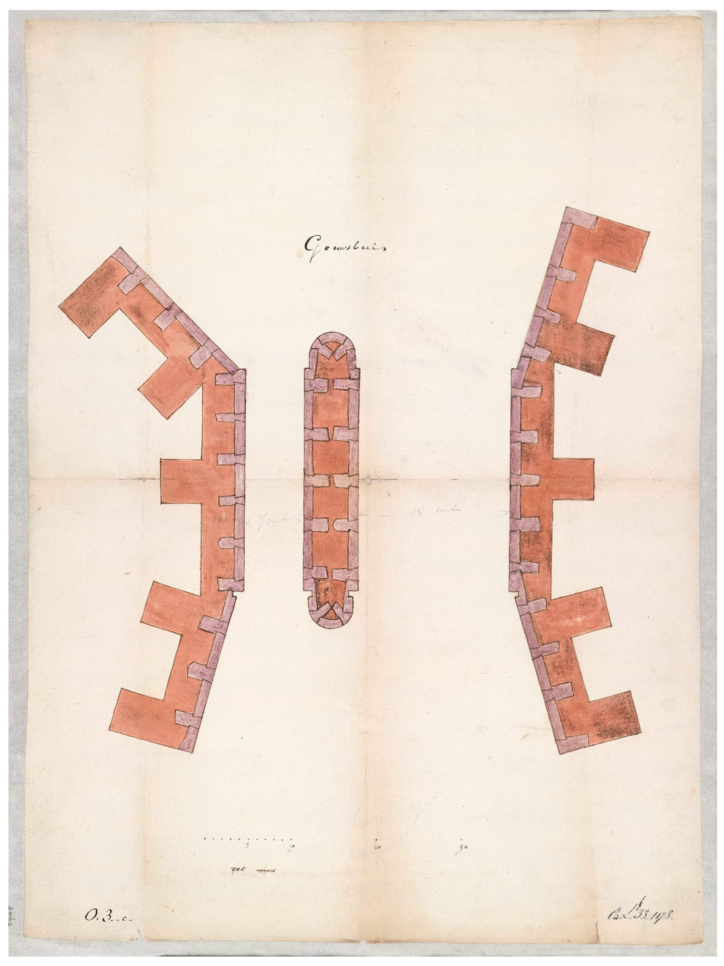
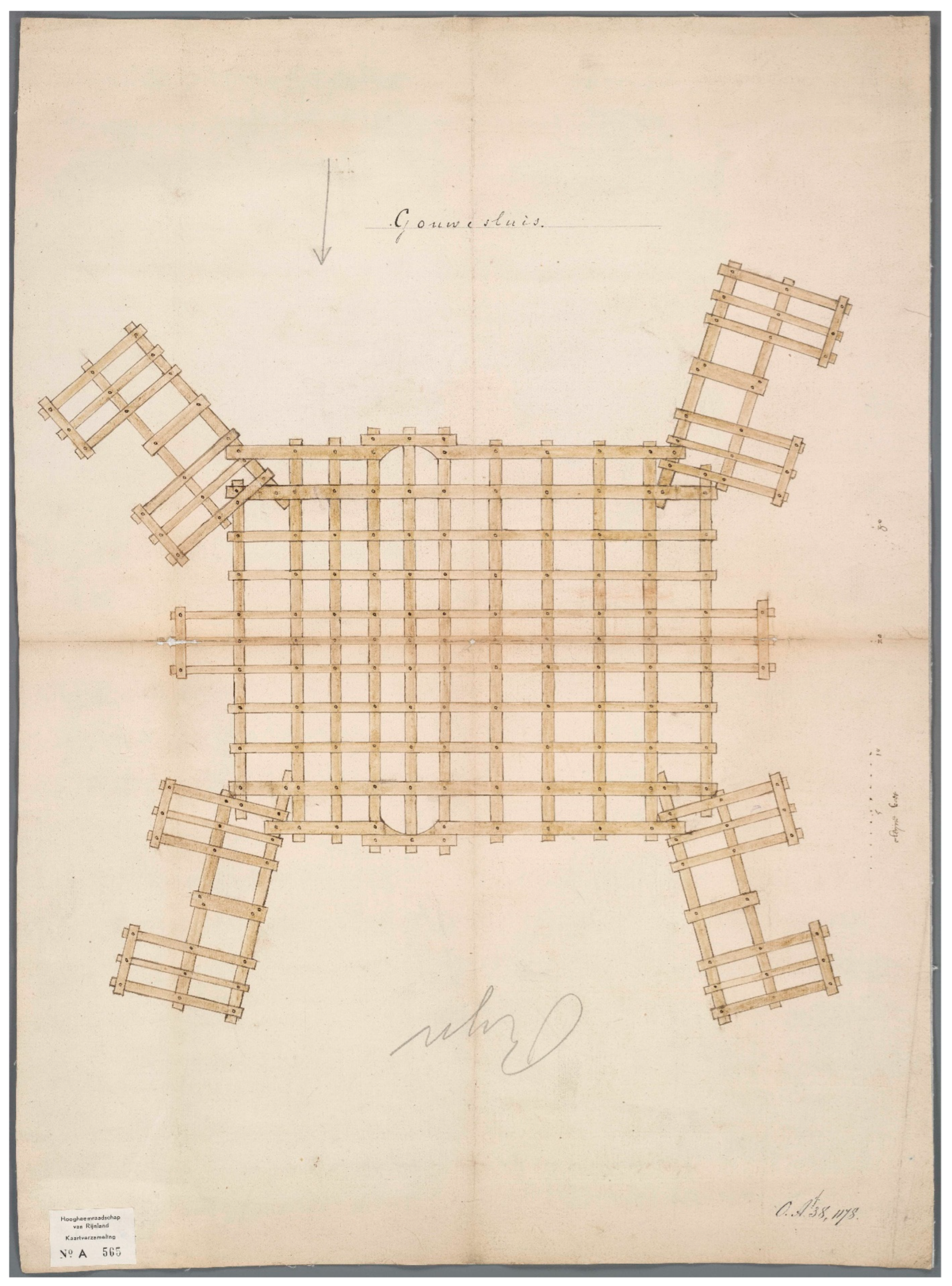
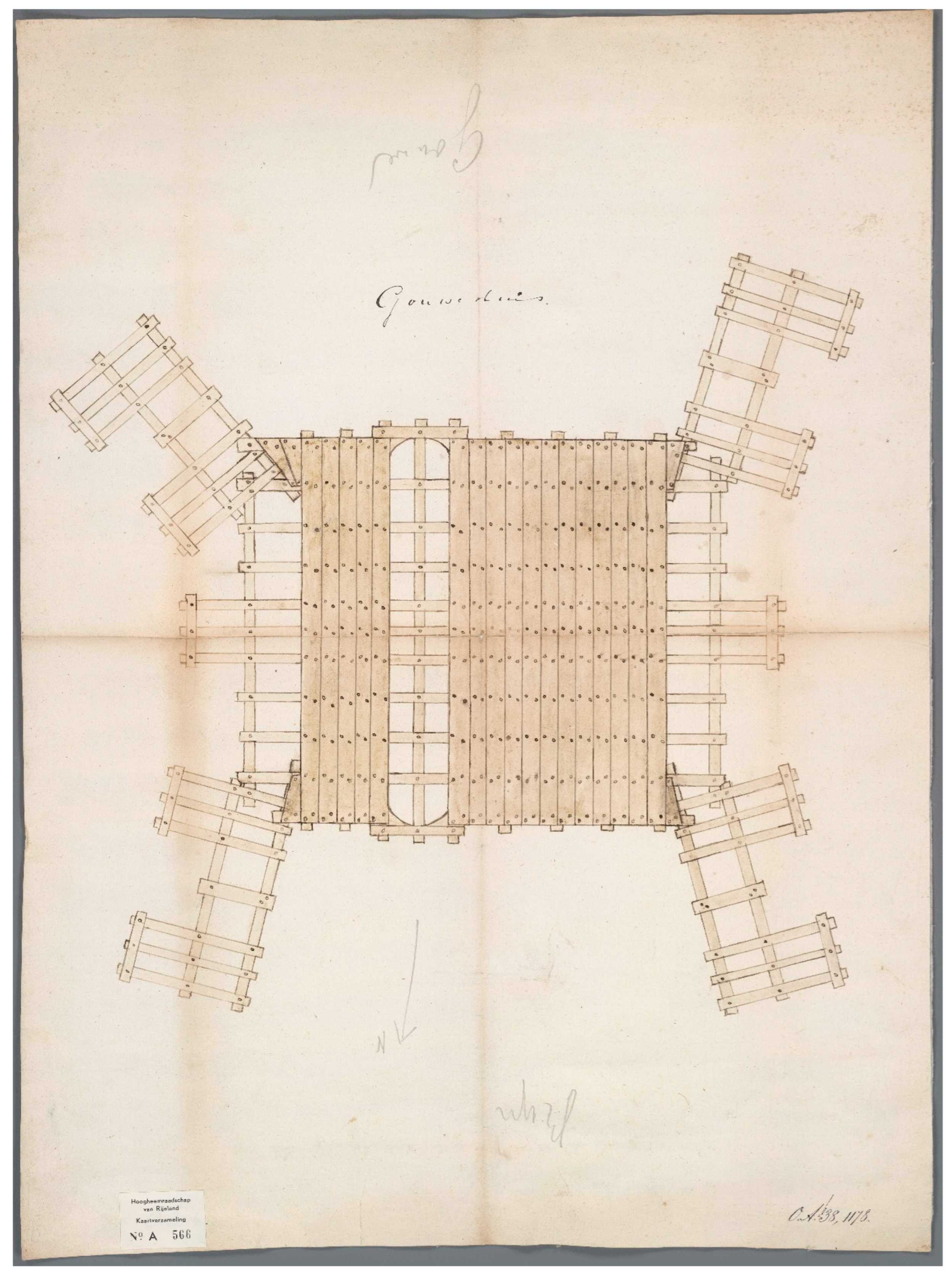
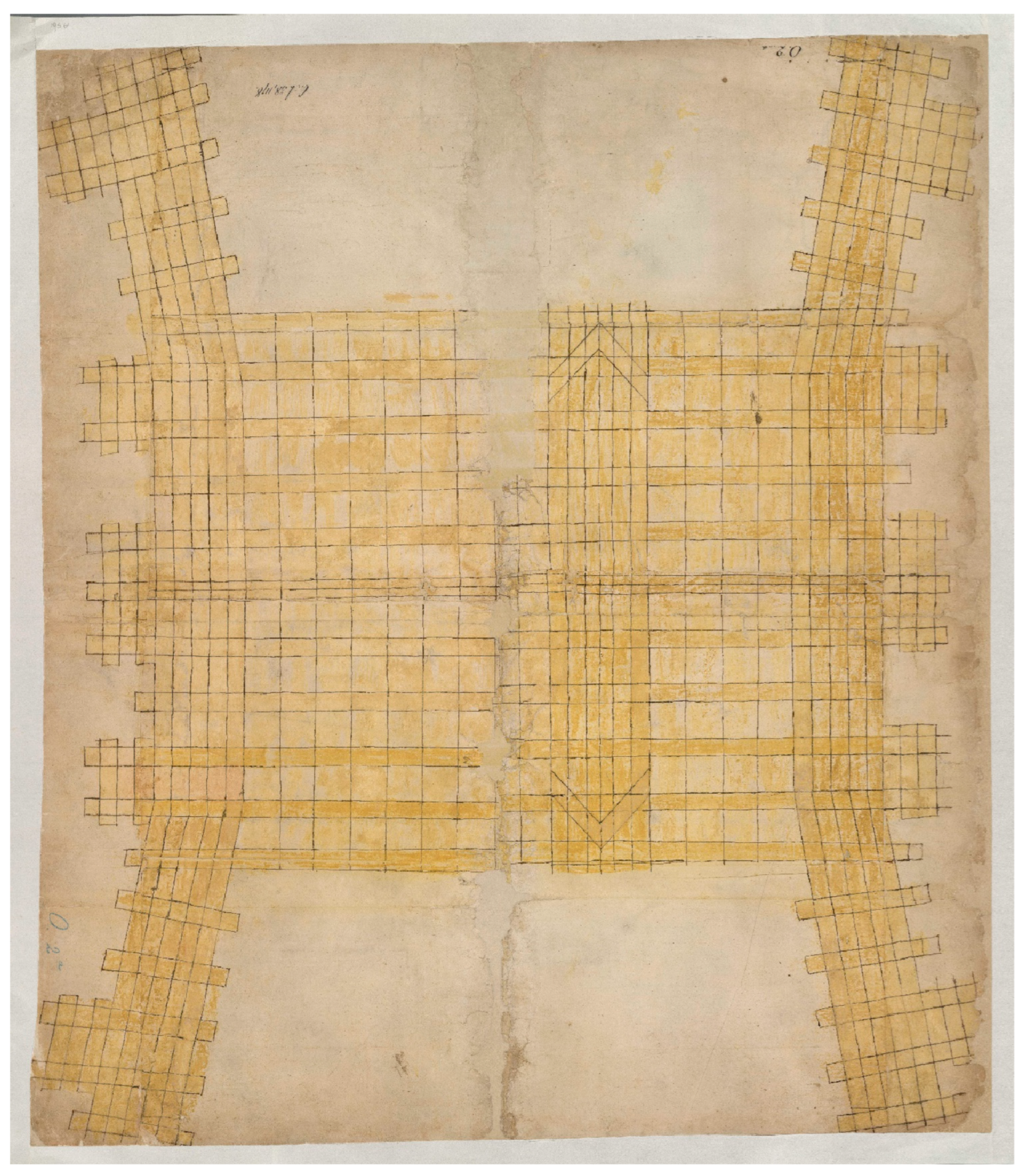
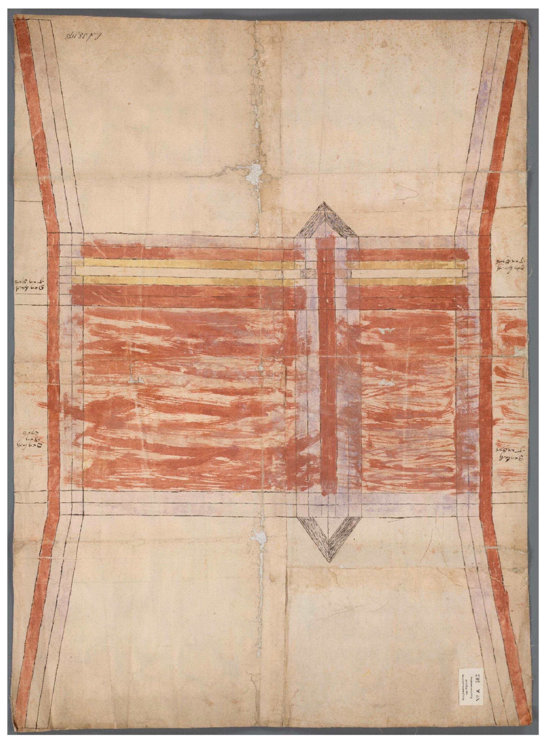
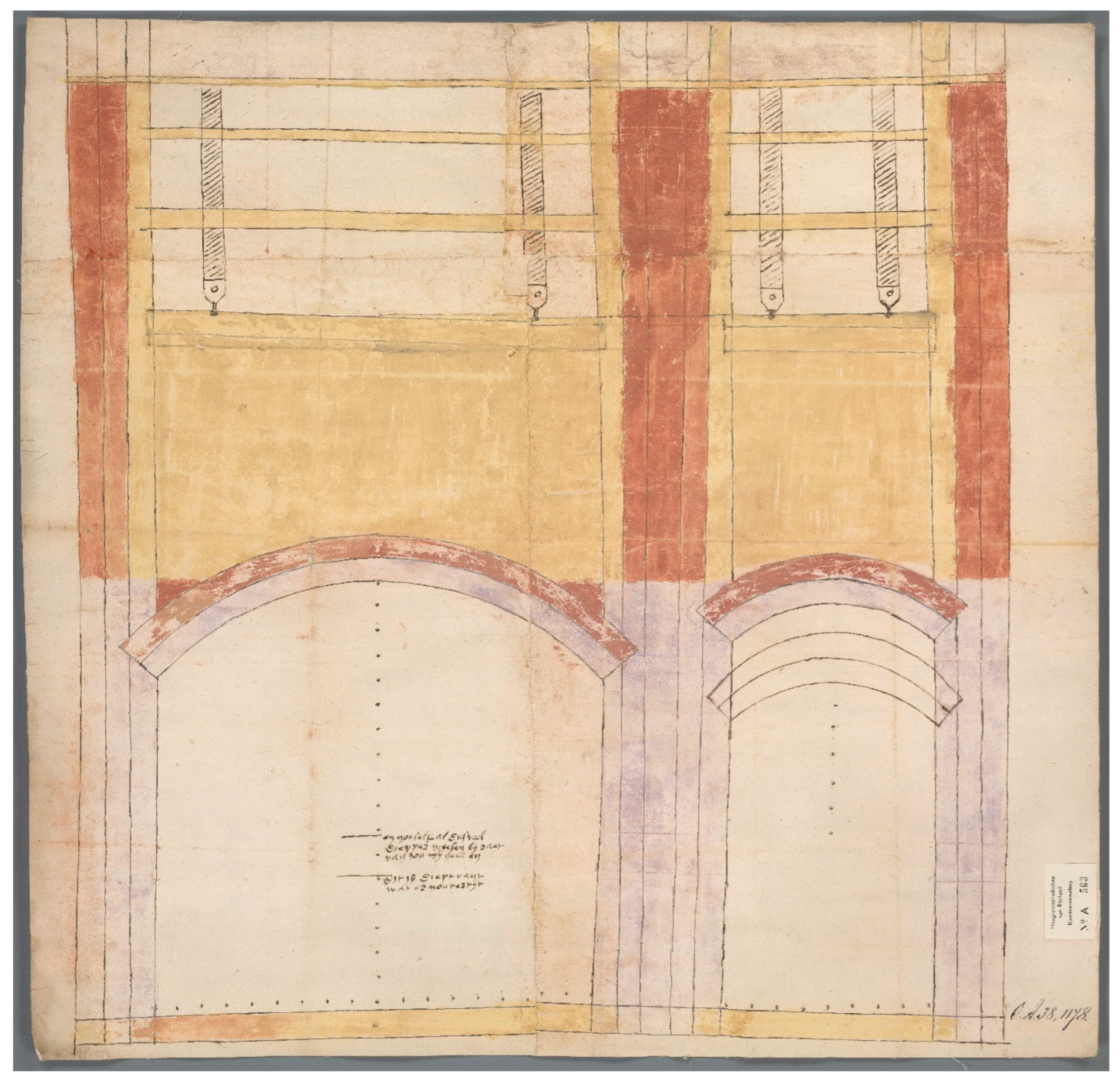
Another stone lock that was planned in the same years, for which a considerable number of drawings remain, is the Gouwsluis near Alphen aan den Rijn, north of Gouda. This new lock at the junction of the rivers Oude Rijn and Gouwe, two of the main shipping routes in Holland, was commissioned by the Rhineland Water Board (Hoogheemraadschap van Rijnland) to improve shipping traffic. This regional government body was responsible for protecting the land from flooding and regulating water levels in the polders, as well as for maintaining waterways in an area stretching from Haarlem and Amsterdam in the north to The Hague and Gouda in the south (Van Dam 2002). The drawings were made between 1562 and 1563 by multiple masters (Hurx 2022, pp. 291–97). One drawing provides a view of the existing lock in the Rhine dike with the elevations of the surrounding buildings in a flattened perspective (Figure 13): the buildings are shown laying on the ground, as seen from the Gouwe River. The other drawings depict three alternative designs for the lock. The first design, which was made in the summer of 1562 by the city architect of Amsterdam, Reynier Corneliszn, has mitre gates (Figure 14) (Hurx 2022, p. 292). An alternative design with sliding or guillotine gates, which was likely made by Cornelis Fredericksz van Montfoort, the master carpenter of Saint-John’s in Gouda (Figure 15, Figure 16, Figure 17 and Figure 18), was put forward in the autumn of the same year. These proposals were the product of a debate on the stability of the foundations and the durability of materials versus the cost of building. The Amsterdam city architect provided the first and, apparently, the most expensive design. In response, Van Montfoort’s design saved on the type of gates but also substituted most of the massive and heavy blue limestone blocks with a combination of bricks and hydraulic cement (Hurx 2022, pp. 294–95). He provided an elevation drawing showing the lock seen from the Old Rhine with the pier separating the two passageways and the wooden frames above for the guillotine gates and a floorplan on the same scale (Figure 15). Interestingly, the drawings demonstrate that Van Montfoort was familiar with Vitruvian terminology: the note on the back of the elevation refers to Die Orthigraphie (Orthografia), while the plan (Figure 16) is called Die Ichnographie of platten grondt (Ichnografia) (Hurx 2020, p. 115). Notwithstanding the reference to the Vitruvian mode of representation, the elevation is not a true orthogonal projection but has been drawn in perspective. In this context, it is noteworthy that the units on the scale bar of both the plan and elevation are labeled in Latin as pes minor. In addition to these drawings, he provided two technical drawings for the foundations, one of the regular grid of the pile foundation (Figure 17), and another with wooden planks atop the grid for the floor of the chamber (Figure 18). The drawing with the grid has a scale bar as well, but here the units are indicated in Dutch: cleyne voet. In response to the earlier proposals, a third design was made in the autumn of 1562 or early 1563 by an unknown draftsman. It exists of two plans, one for the foundations (Figure 19), and another one for the level of the pier (Figure 20), as well as an elevation of the Gouwe side (Figure 21). Like Van Montfoort’s design, it provided guillotine gates, but the bluish colour indicates that stone was used for the cladding of the pier and for the arches, while the red of the core pier and the upper parts suggests bricks. However, it seems that a cheaper alternative for the foundations was proposed (Hurx 2022, pp. 296–97). The drawing does not depict a grid in which the empty spaces were to be rammed in with piles, but it probably shows a “raft”, which is a platform of tightly joined plank boards supporting the entire masonry. The accounts of the water board confirm that in November 1562, it was decided to construct the lock without a pile foundation to save costs.
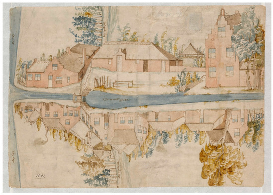
Figure 13.
Unknown draftsman, map or bird’s eye view of the existing lock, the Gouwsluis, in the Rhine dike at the junction of the rivers Oude Rijn and Gouwe at Alphen aan den Rijn, 1562. The elevations of the surrounding buildings are depicted in flattened perspective. Oud Archief van Rijnland, Leiden, Collectie Kaarten, A 560 (© Hoogheemraadschap van Rijnland, Leiden (NL-LdnHHR)).
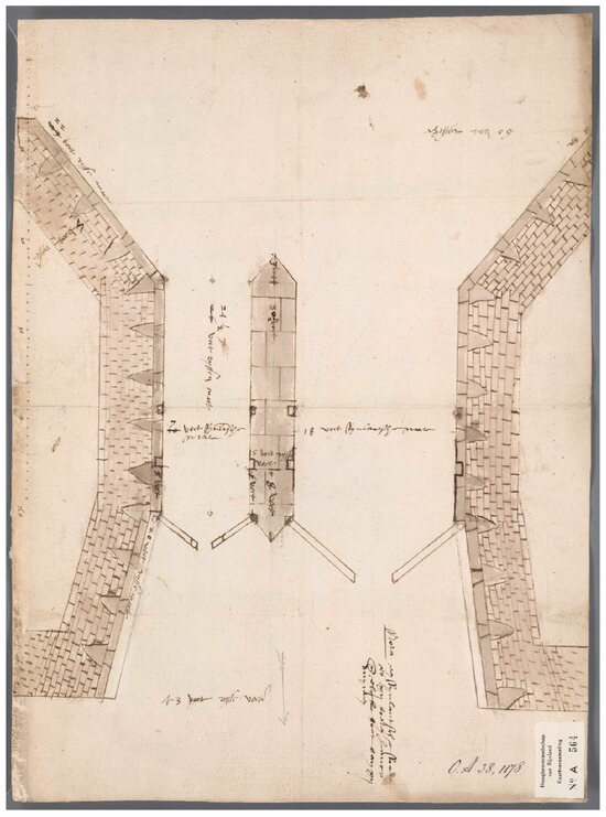
Figure 14.
Reynier Cornelisz, plan of the Gouwsluis at Alphen aan den Rijn, 1562. The north is at the bottom. The verso contains the note: Mr. Reyer stadsmetselaer tot Aemstelredam, Oud Archief van Rijnland, Leiden, Collectie Kaarten, A 564 (© NL-LdnHHR).
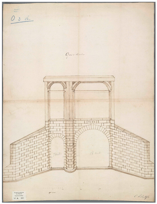
Figure 15.
Cornelis Fredericksz van Montfoort (attributed), elevation of the Gouwsluis seen from the Oude Rijn at the north, 1562. The verso contains the note: Die Orthigraphie ofte Recht opstaende bescrivinghe ende toninghe van de Sluyze tot Alphen, Oud Archief van Rijnland, Leiden, Collectie Kaarten, A 568 (© NL-LdnHHR).
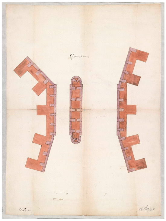
Figure 16.
Cornelis Fredericksz van Montfoort (attributed), plan of the Gouwsluis, 1562. The north is at the bottom. The verso contains the note: Die Ichnographie of platten grondt van de Sluyse in den Rijndijck leggende tot Alphen, Oud Archief van Rijnland, Leiden, Collectie kaarten, A 567 (© NL-LdnHHR).
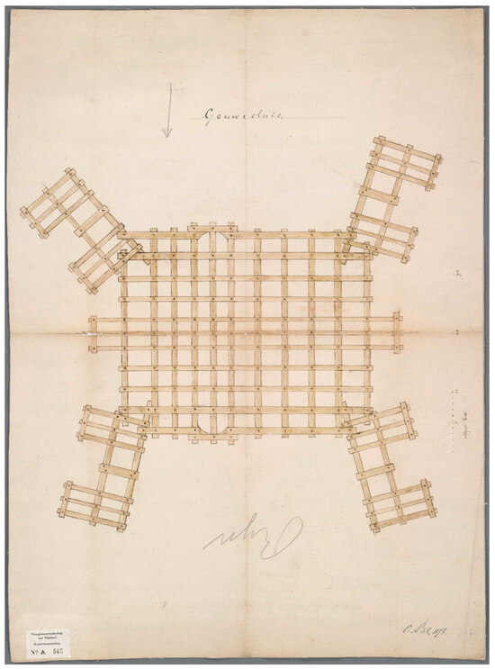
Figure 17.
Cornelis Fredericksz van Montfoort (attributed), plan of the foundations of the Gouwsluis, 1562. The verso contains the note: Het Slothout of den eersten Gront van de Goutsche Zluyse leggende tot Alphen in den Rijndijck, Oud Archief van Rijnland, Leiden, Collectie Kaarten, A 565 (© NL-LdnHHR).
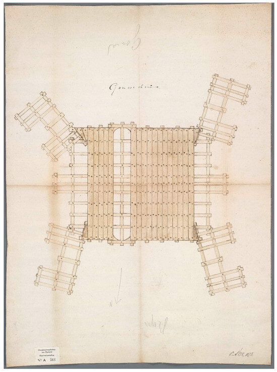
Figure 18.
Cornelis Fredericksz van Montfoort (attributed), plan of the floor of the sluice chamber of the Gouwsluis, 1562. The verso contains the note: Den Boedem of den Tweeden grondt van de Goutsche Zluyse leggende tot Alphen in den Rijndijck, Oud Archief van Rijnland, Leiden, Collectie Kaarten, A 566 (© NL-LdnHHR).
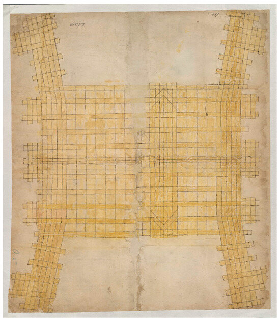
Figure 19.
Anonymous draftsman, plan of the foundations of the Gouwsluis, 1562–63. The north is at the top, Oud Archief van Rijnland, Leiden, Collectie Kaarten, A 561(© NL-LdnHHR).
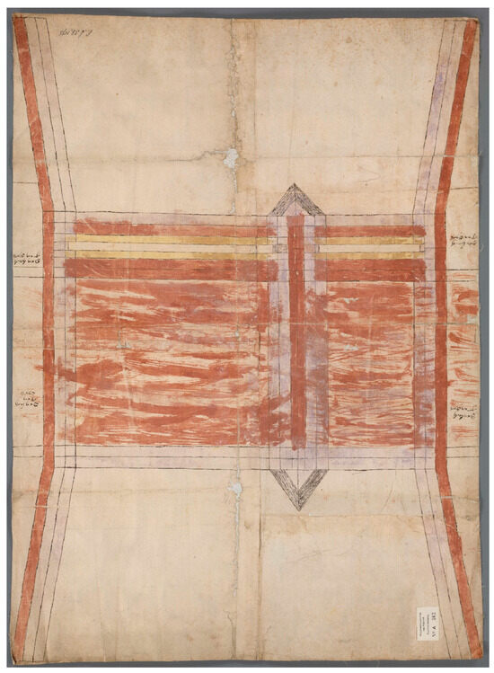
Figure 20.
Anonymous draftsman, plan of the level of the pier of the Gouwsluis, 1562–63, The north is at the top, Oud Archief van Rijnland, Leiden, Collectie Kaarten, A 562 (© NL-LdnHHR).
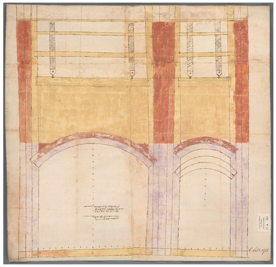
Figure 21.
Anonymous draftsman, elevation of the Gouwsluis seen from the south, 1562–63, Oud Archief van Rijnland, Leiden, Collectie Kaarten, A 563 (© NL-LdnHHR).
The drawings of the Vaartse lock and the Gouwsluis reveal that the design of locks was done with painstaking effort. Graphic aids and models were used to discuss alternative solutions and also served as a tool to instruct the builders. In these examples, multiple projections were combined at the same scale, and in the drawings by Reynier Corneliszn and Van Montfoort, scale bars are clearly marked. This may have facilitated their use at the building yard.
5. Building a Stone Sluice at Halfweg
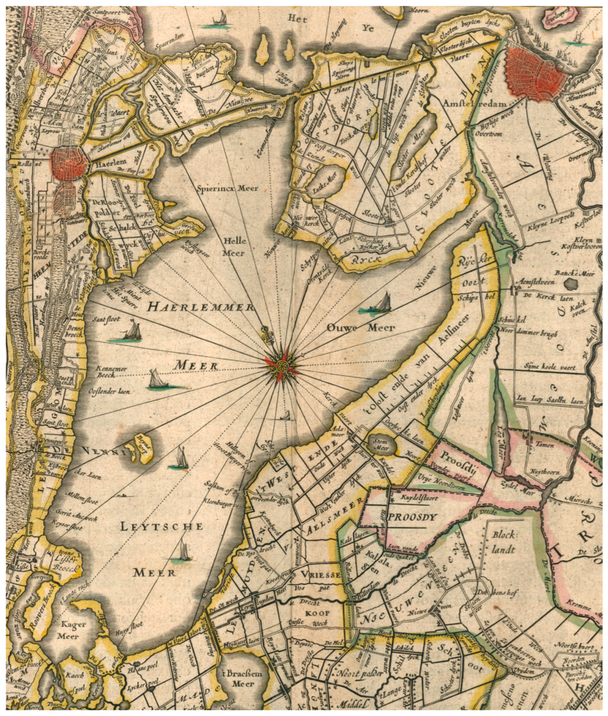
The design of the sluice at Halfweg, a few years earlier, did not arouse a debate as fierce as in Alphen aan den Rijn, but the surviving drawings provide an even better view of the use of graphic aids as a guide in the planning and building process. In early June 1556, the Rhineland Water Board discussed the construction of two discharge sluices in the Spaarndammer dike at Halfweg, which were to replace the existing sluice that was damaged beyond repair by a storm a few years earlier (Van Amstel-Horák 1994). The sluices at Halfweg, which derives its name from its location approximately halfway between Amsterdam and Haarlem, were to improve the drainage of water from the Spieringmeer, part of the Grote Haarlemmermeer, the largest lake in Holland, into the IJ, which was at that time was an extremity of the sea, called the Zuiderzee (Figure 22), and which, therefore, was subject to the tides. Halfweg was the main water outlet for the area administered by the water board. The sluice, which was constructed in the sea dike, was to keep water out from the sea at high tide and discharge excess water from the lake at low tide. The construction of the stone sluice was something of a novelty in the Rhineland, and the drawings, building specifications, accounts, and letters surviving in the archive of the water board testify to its careful planning (For the development of foundations techniques for sluices, see Hurx 2022; Van Dam 1994, 2002; Van Amstel-Horák 1994). On 18 June, 1556, 2 days after a board meeting in which the idea of a building stone sluice was first discussed, a messenger was sent to Cornelis Fredericxz (called vander Goude) in Gouda (this master is not to be confused with the master carpenter Cornelis Fredericksz van Montfoort mentioned above) (OAR, 1.1.1, inv. no. 9578, f. 495r.). He was master of the works of Saint John’s in Gouda, which was the largest ongoing ecclesiastical building project in the Northern Low Countries at that moment: the church was rebuilt with much ardour after a devastating fire in 1552. At Gouda, Fredericxz was responsible for an innovative plan that maximised the size of the stained-glass windows of the church through the use of tall gables (OAR, 1.1.1, inv. no. 4856). In 1556, he already had a long career behind him: one of his earliest mentions dates to 1526, when he assisted his brother Hubrecht Fredericxz, who supervised the laying of foundations of Schoonhoven Castle of Emperor Charles V (Nationaal Archief, The Hague, Grafelijkheidsrekenkamer, 5008, f. 156v.). Cornelis Fredericxz guided the works at several churches, and in 1531, he was consulted on the foundations in the reconstruction of the church tower in Culemborg (Van den Berg 1963, 2008). He was also involved in infrastructural and hydraulic works: for instance, in 1546–47, he built the lock called the Grote of Hondsbosscher Sluis in Zaandam, and in 1548, he built a sluice, called the Maaslandersluis, at Vlaardingen, and he contracted a stone bridge in Rotterdam while working at Halfweg (Thijssen 2001 p. 7; Van Amstel-Horák 1994, p. 63; OAR, 1.1.1, inv. no. 4856).
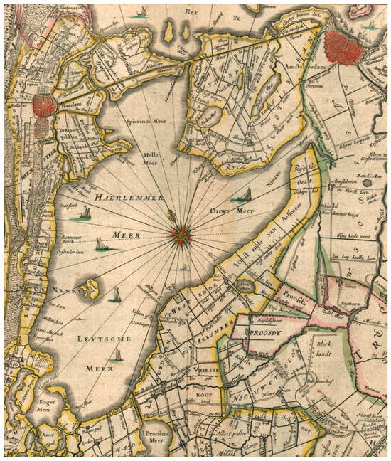
Figure 22.
Joan Blaeu, detail of the map of Rhineland and Amstelland showing the Spieringmeer as the northern part of the Grote Haarlemmermeer with the dike at Halfweg—halfway Amsterdam and Haarlem—separating the lake from the sea, the IJ, in: Atlas Maior, Amsterdam 1664–65, vol. 3, second part, p. 41 (© Wikimedia Commons).
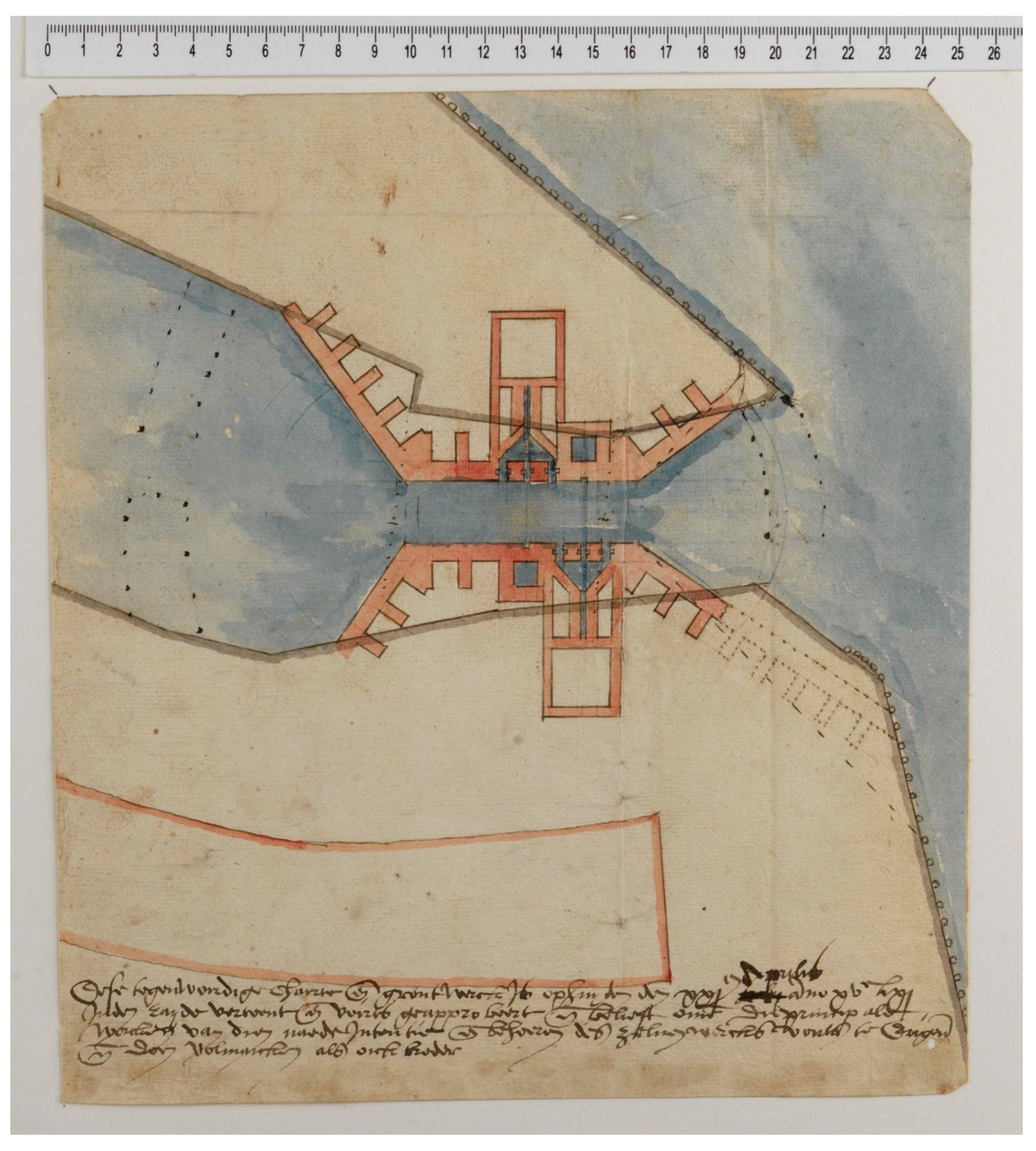
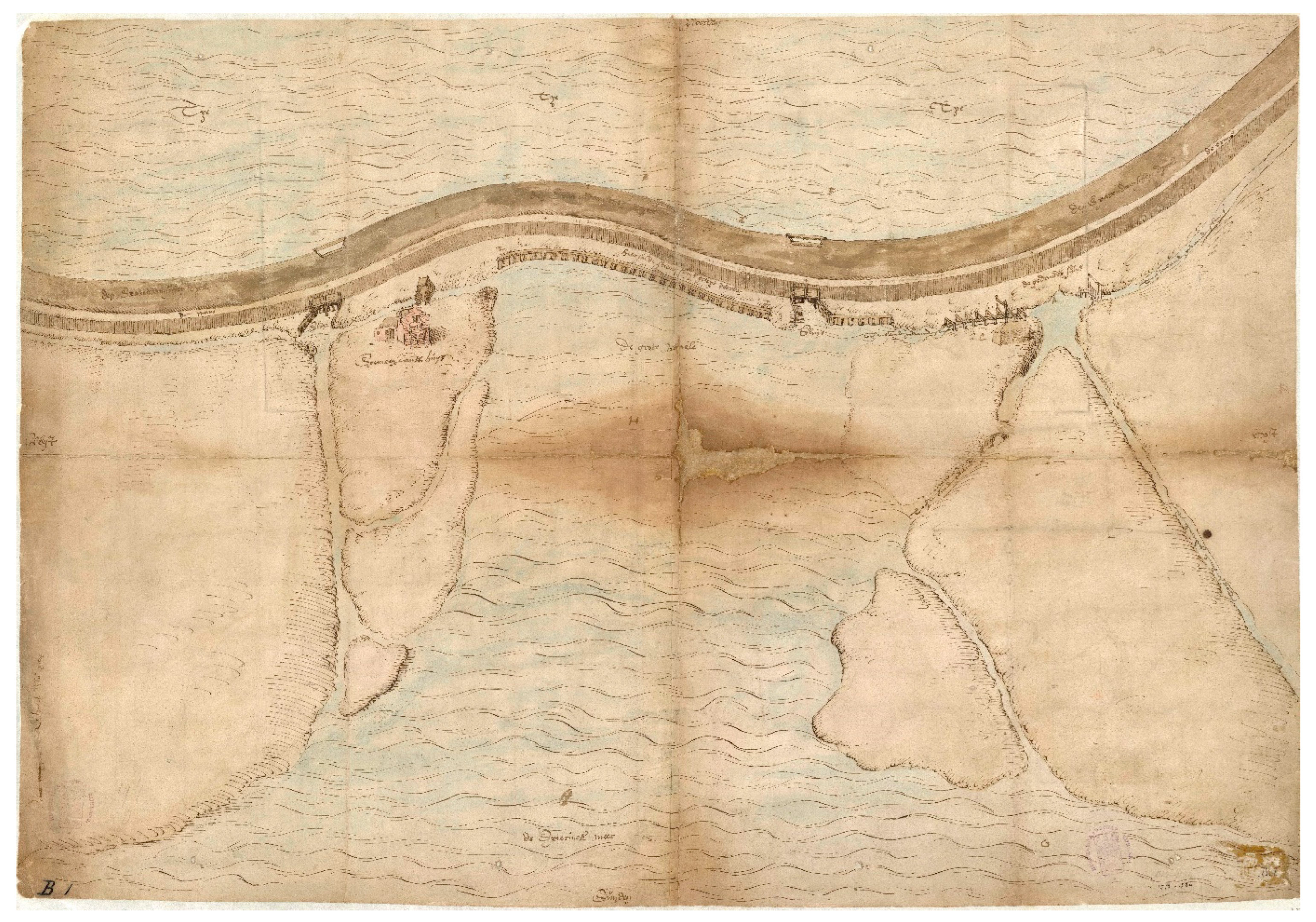
At the board’s request, Fredericxz immediately travelled to The Hague for instructions, after which, on 20 June, 1556, he continued his journey to Halfweg in the company of the water board’s receiver. Here, he investigated the ground conditions to see if the site was fit to construct a stone sluice. He set to work energetically and made a report and cost estimate, together with a ground plan (grondt) and an elevation (pouirtracture) of the new sluice, which he presented to the water board once back in The Hague.8 The payment for a “map” (charte) in the accounts may refer to a ground plan as it is the same word used for Van Noort’s first drawing discussed above. However, in this case, it could also designate a true map, because a map, or, perhaps better, a bird’s eye view of the area survives (Figure 23). This document, which carries the note Chaerte, shows the dike with the IJ above (north) and the Spieringmeer and its outlet called the Grote Waele below (south). On the right, indicated by the letter A, is the damaged sluice that was closed off in 1555, while in the centre, a newly planned timbered sluice is depicted (Diebels 1986, pp. 20–21). In between this sluice and the little building on the left, the “Gemeenlandshuis”, which is the water board’s local office building, a note indicates the future position of the stone sluice: “Here will come the stone sluice” (Hier sal de steenen sluys geleyt werden). Possibly, this drawing can be identified with the map made by Fredericxz during this first visit to the site, even though he made another map (cairte) in the spring of 1557, and also a painter, Bouwen Roeloffs, was paid for a map (cairte) of the dike and its surroundings in July of that year9 However, by that time, the digging of the building pit had already begun, and a masons’ lodge had been built next to the water board’s office. As these elements lack in the surviving map, it must have been made earlier, before April 1557 (OAR, 1.1.1, inv. no. 9578, f. 579r.).
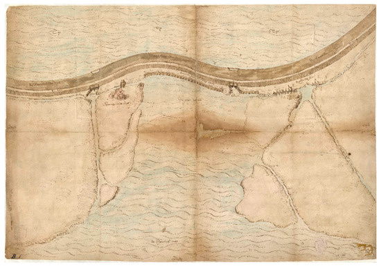
Figure 23.
Cornelis Fredericxz vander Goude (attributed), map or bird’s eye view of the area where the stone sluice was to be built in the Spaarndammerdijk at Halfweg, 1556–57, Oud Archief van Rijnland, Leiden, Collectie Kaarten, A 846 (© NL-LdnHHR).
The sluice designed by Fredericxz was made of Bentheimer sandstone (from Bentheim and Gildehaus, now in North Rhine-Westphalia, Germany) and bricks. It had barrel-vaulted sluice chambers with two pairs of mitre gates, measuring about 70 feet long and 20 feet wide (about 22 m and 6.3 m, according to the Rhineland foot of 31.4 cm). Its design closely resembled the Grote of Hondsbosscher Sluis in Zaandam, which Fredericxz had made 10 years earlier. Before the decision on the construction of the stone sluice was taken, multiple master masons and carpenters were invited in July 1556 to provide a rough estimate of the costs (Van Amstel-Horák 1994, p. 63). The water board proposed that it should not exceed 1.5 times the cost of a timbered sluice, and all experts optimistically confirmed that this was a reasonable estimate.10 While, in this case, no motivation for the preference for a stone sluice is provided, other resolutions by the water board show that durability was the main concern as timbered sluices had an expected lifespan of only about 25 years (OAR, 1.1.1, inv. no. 21, f. 49r.).
On 9 October, 1556, Fredericxz was officially appointed as master of the works by the water board. His contract stipulated that he was to direct the works onsite. During the time of construction, he and his wife were allowed to use the Gemeenlandshuis as lodgings (OAR, 1.1.1, inv. no. 4856; See Van Amstel-Horák 1994). The start of the works was set for the new building season in March 1557. Meanwhile, over the winter, preparations were being made: the construction of the dams for the building pit was contracted out, and stone and bricks were procured.
With the start of the new building season, a messenger was sent to Gouda on 1 March, 1557 to ask Fredericxz to begin with the works at Halfweg. Two weeks later, a timber masons’ lodge was erected next to the local office building, the Gemeenlandshuis (OAR, 1.1.1, inv. no. 9578, f. 501r. and f. 563r.). However, a serious problem soon arose: in early May, it was discovered that one of the dams of the building pit was slowly subsiding. Fortunately, the Spaarndammer dike had not been opened yet, so there was no risk of flooding the hinterland, but several experts were consulted. They advised to postpone the work until the start of the next building season of 1558: if the dams survived the autumn and winter storms, it would be safe to breach the dike (OAR, 1.1.1, inv. no. 21, f. 24r.-v). The cutting of stone and timber could continue uninterruptedly. The preparations proceeded smoothly: In July 1557, a cabinet maker provided the wooden stonecutters’ templates for the stones of the arches of the barrel vaults of the sluice chambers.11 By December, the stones and planks for the floor of the sluice chamber were finished (OAR, 1.1.1, inv. no. 21, f. 24r.-v). In early spring 1558, the work recommenced, and construction proceeded rapidly since most materials had been fully prepared in the previous year. By the end of April, the water in the building pit had been drained, and the exact position of the ground plan was determined. Fredericxz proposed to either adjust the sluice’s original position slightly in the direction of the IJ or to extend the foundations. Two master carpenters were asked to evaluate the soundness of his adjustments, after which they prepared the building site by leveling the pit 7 feet below the waterline using ropes to mark out the ground plan (OAR, 1.1.1, inv. no. 9578, f. 447v). In May 1558, the piles of the foundations supporting the heavy blue limestone sills, which were to prevent the doors from collapsing under the pressure of the incoming seawater, were rammed in. The construction of the masonry was also done at a high pace: in the 1st week of August, the timber for the centring for the vaults of the sluice chambers was supplied (OAR, 1.1.1, inv. no. 9578, f. 243r). Two months later, in early October, the sluice was complete and members of the water board and four master carpenters inspected the sluice to check that it was properly finished (OAR, 1.1.1, inv. no. 9578, ff. 436v.-437r., f. 439r.-v.; Van Amstel-Horák 1994, p. 68).
6. Drawings for Halfweg
The 19 preserved drawings for the sluice at Halfweg reflect the sluice’s meticulous planning process. They were also made in response to particular problems that arose during construction. It seems likely Cornelis Fredericxz made the entire set himself. As discussed above, he received multiple payments in 1556 and 1557 for plans and elevations, and he also is recorded to have made the stonecutters’ templates (OAR, 1.1.1, inv. no. 9578, ff. 603r.-604r., ff. 610v.-611v). The making of drawings and templates continued well into the building process; even up to his death in 1560, he provided templates and drawings for the copings of the blue limestone that were put on top of the balustrades of the sluice.
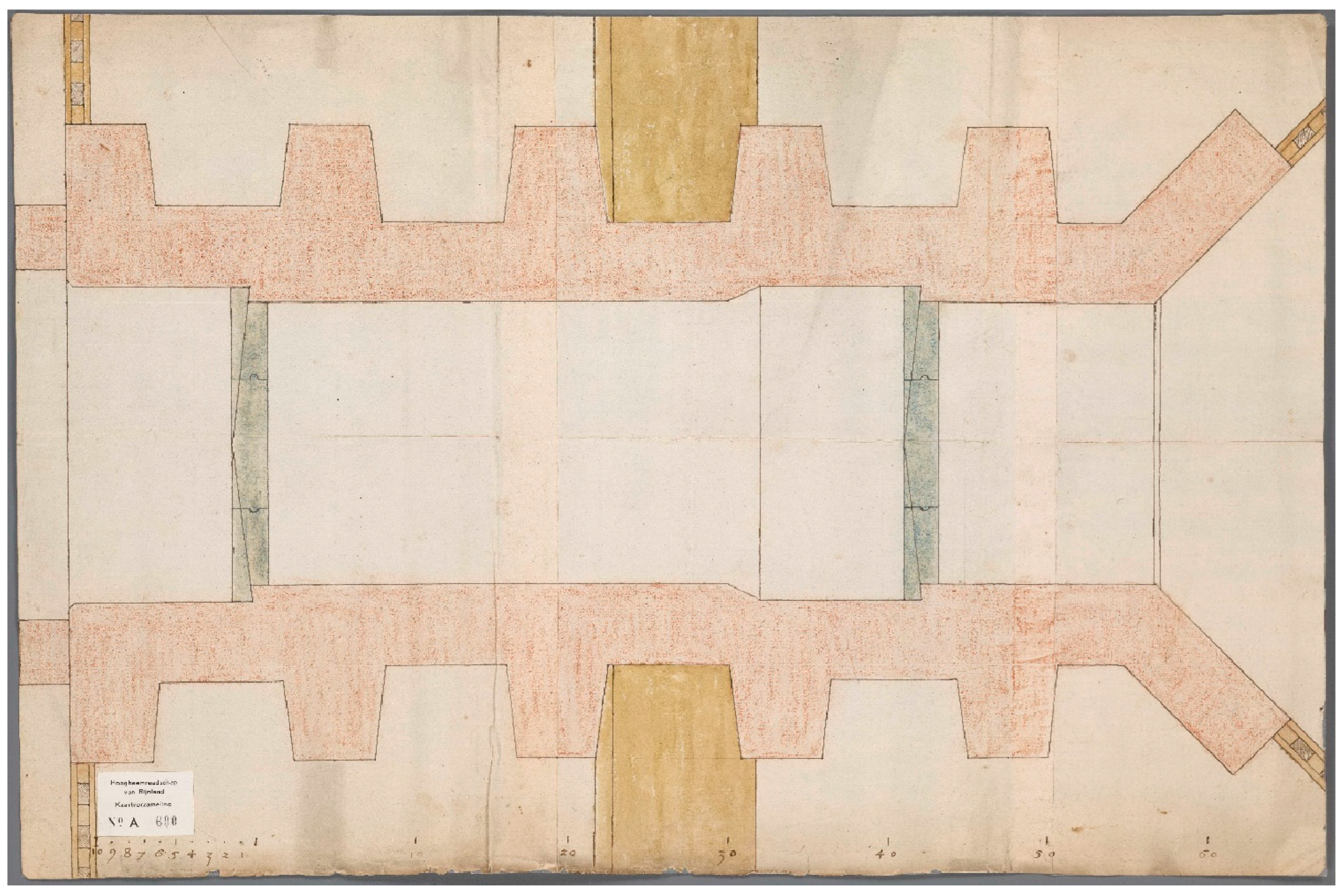
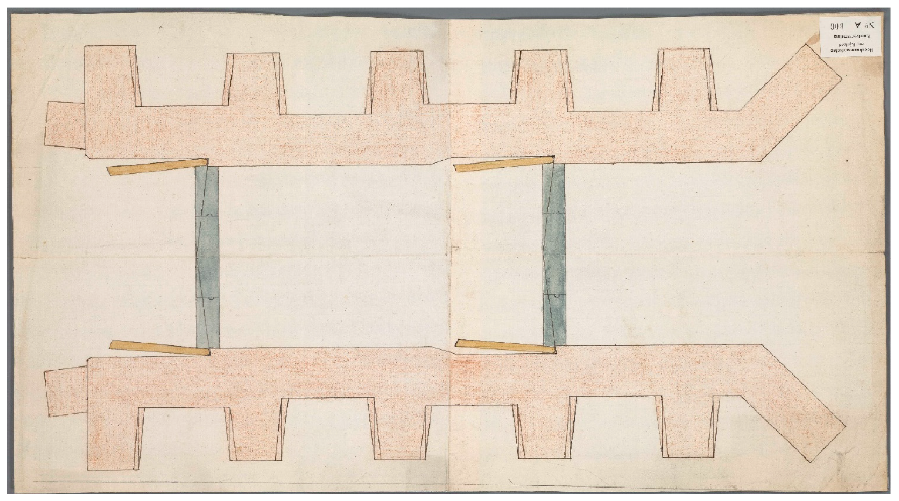
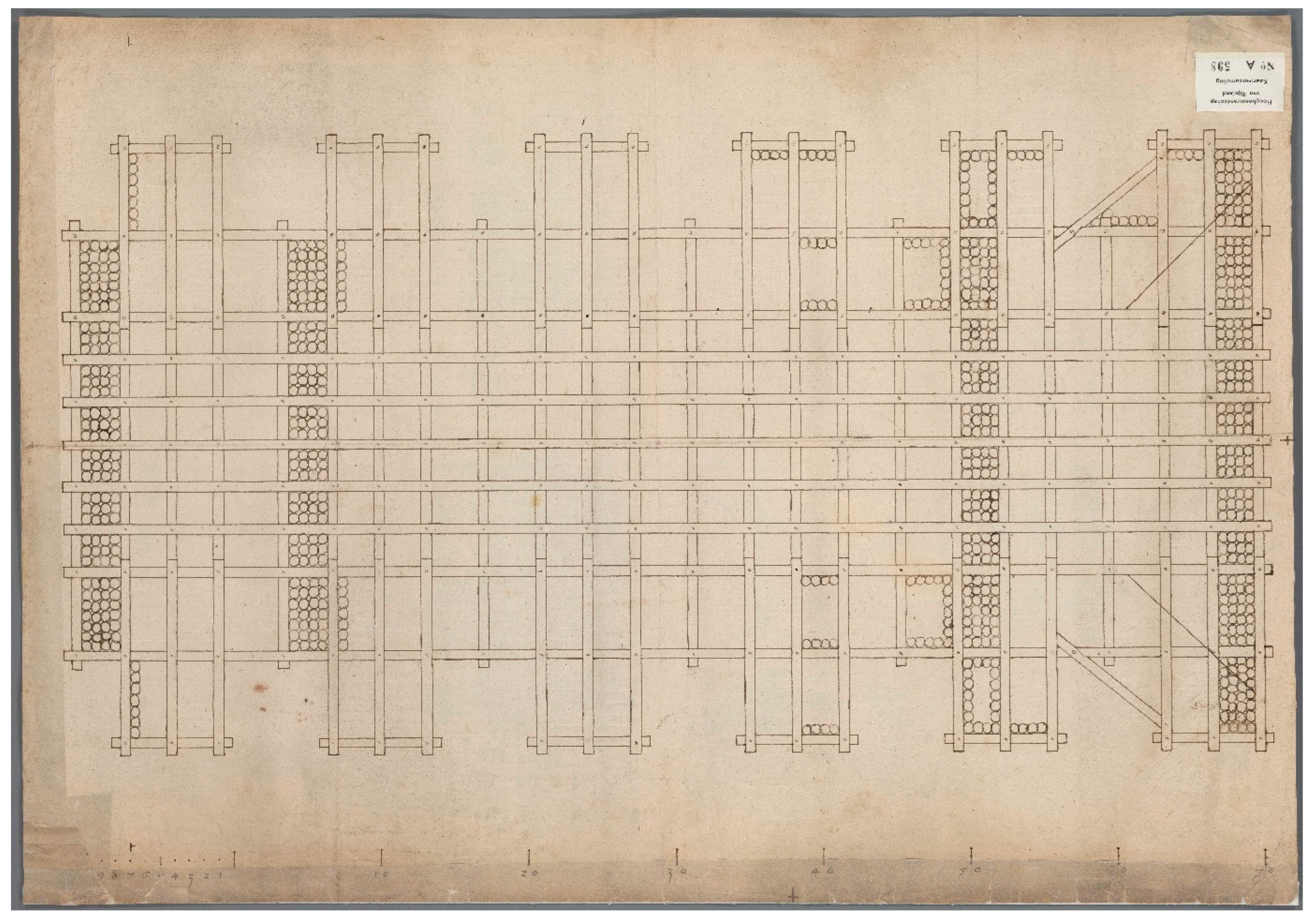
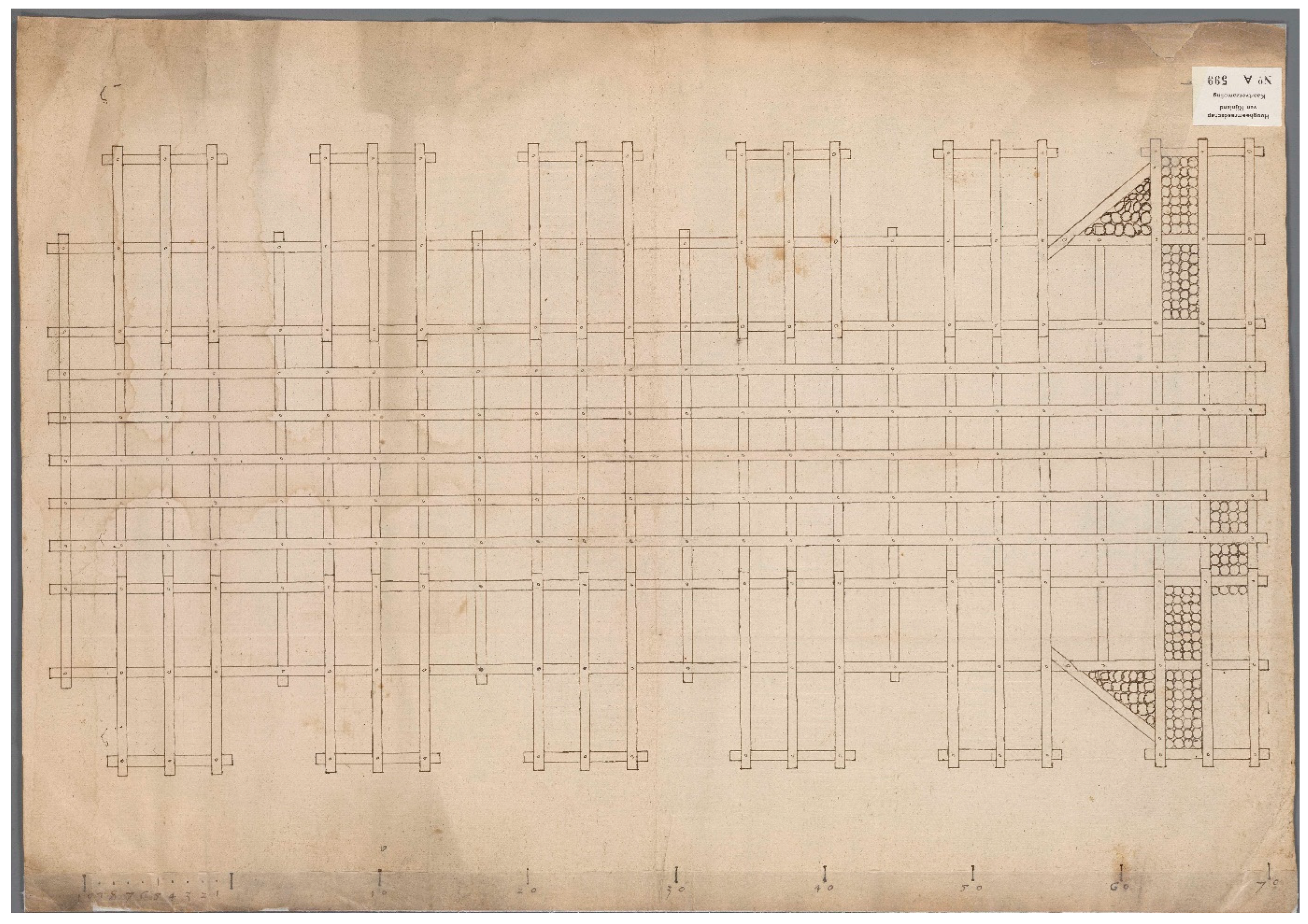
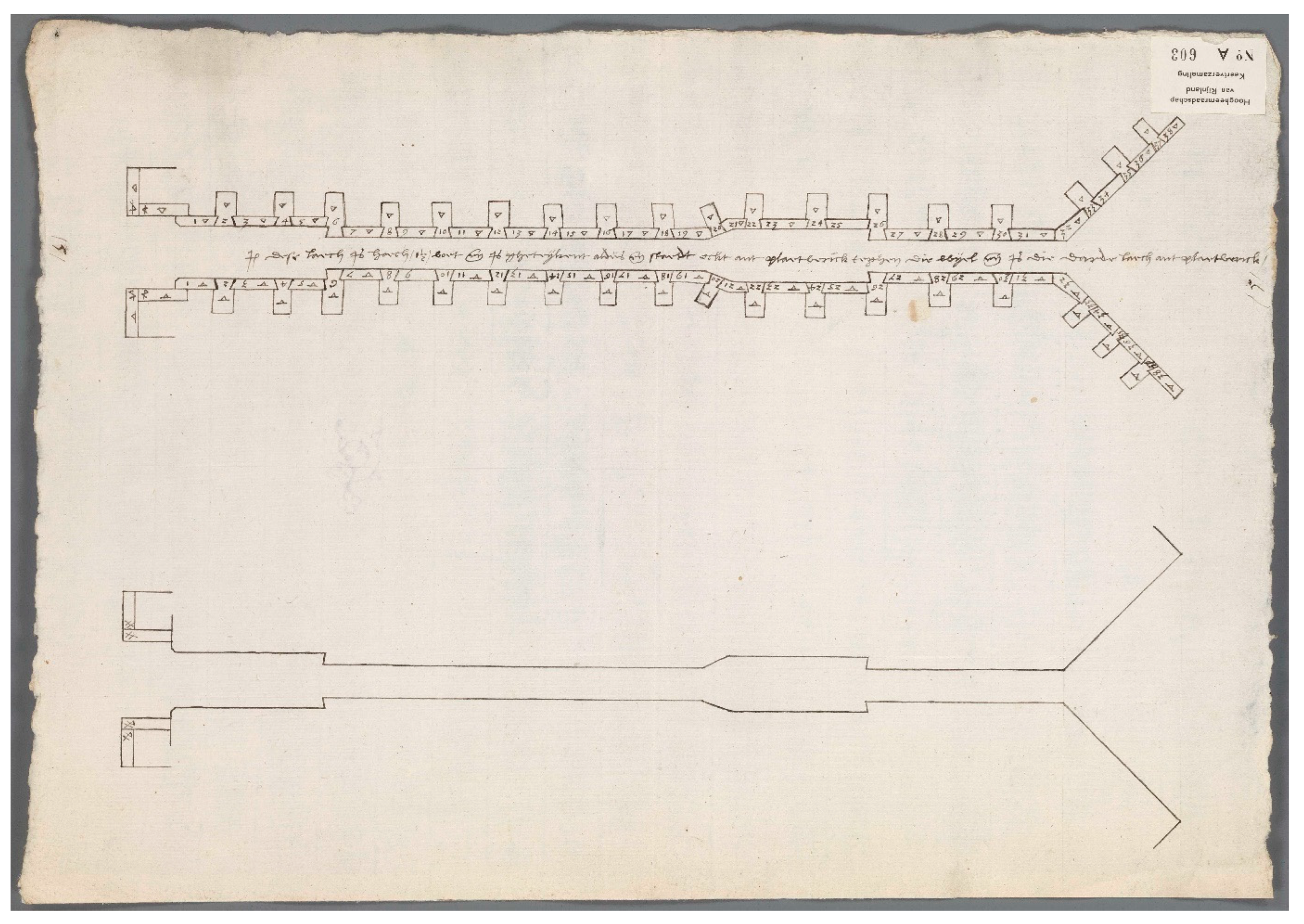
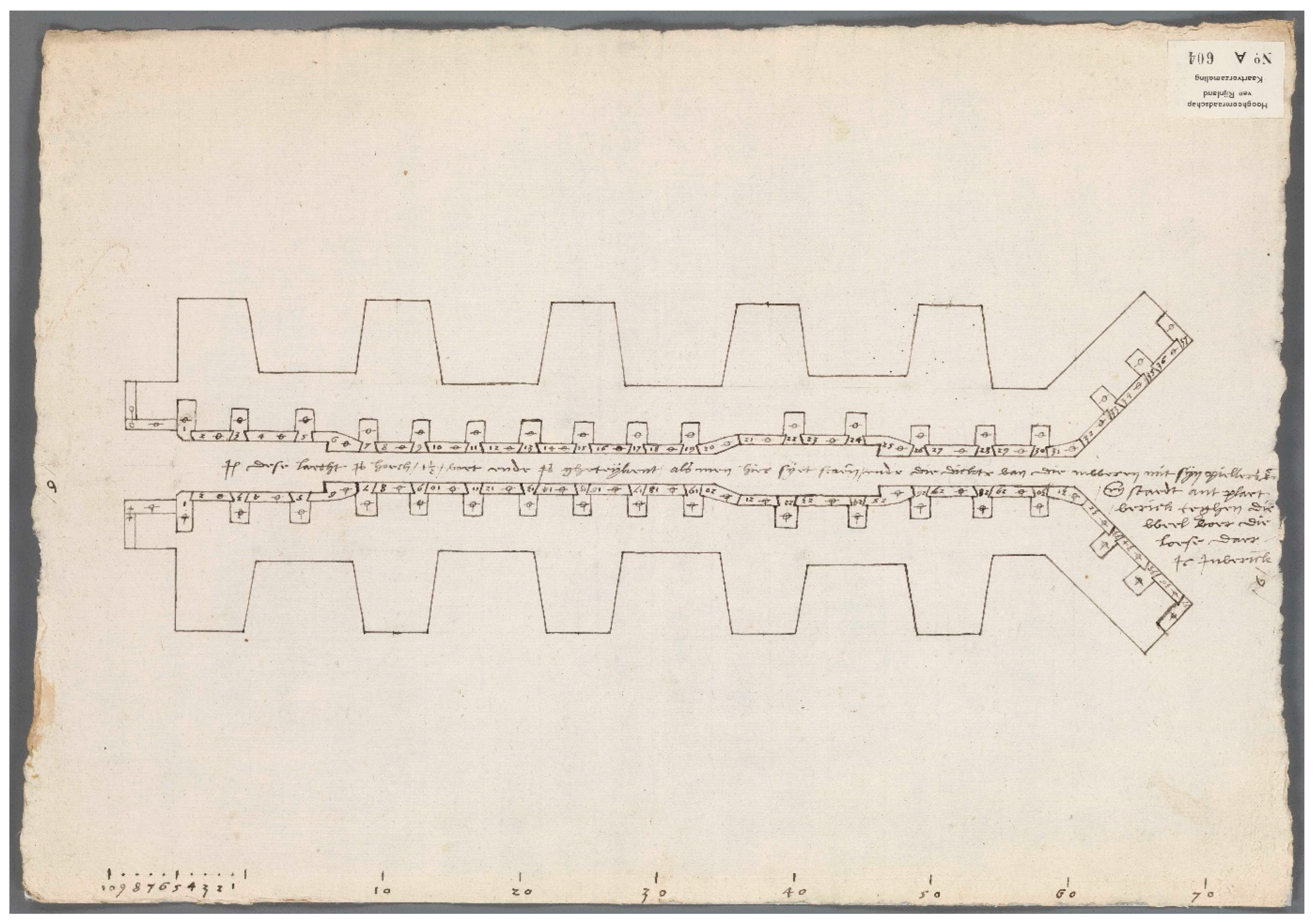
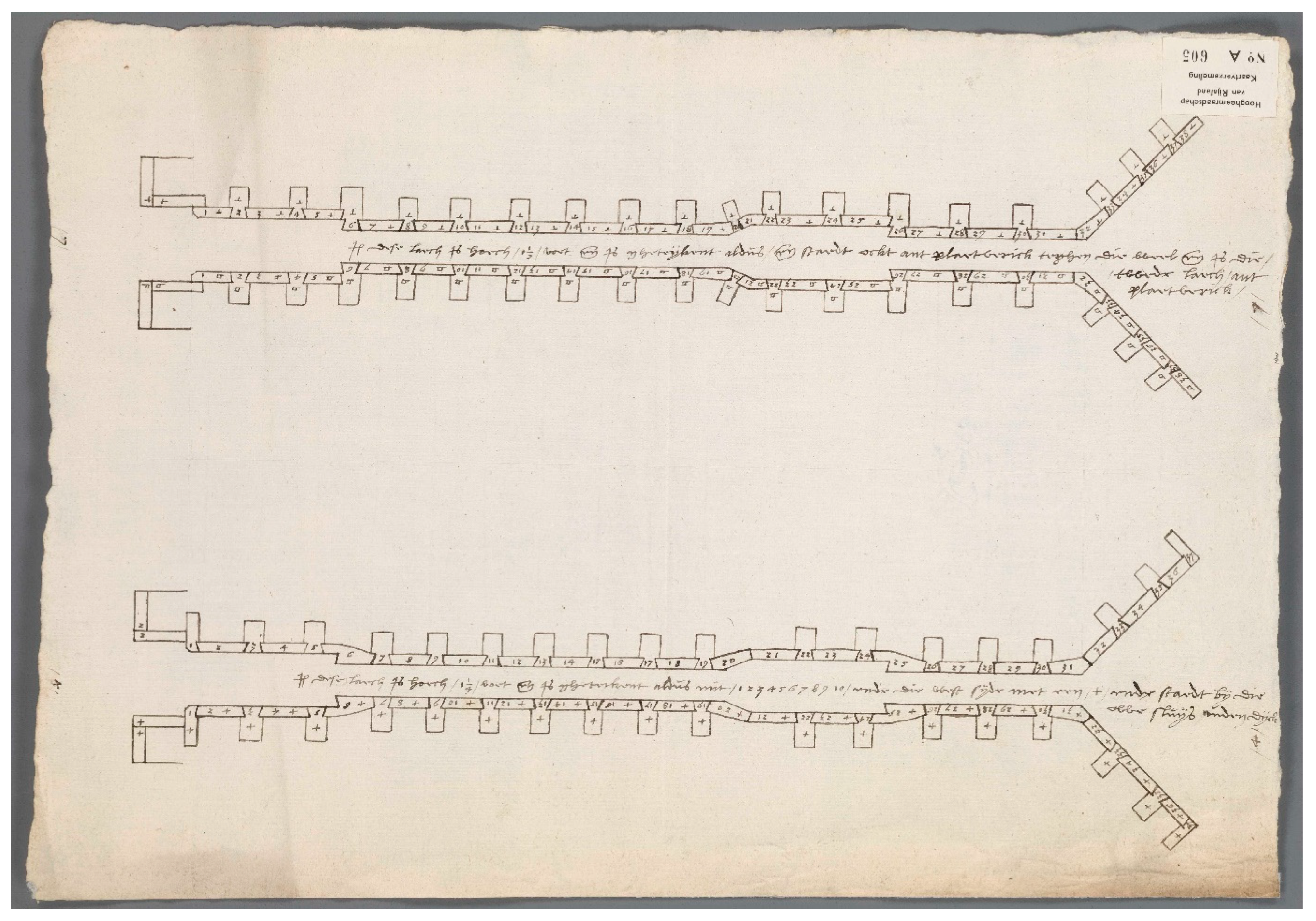
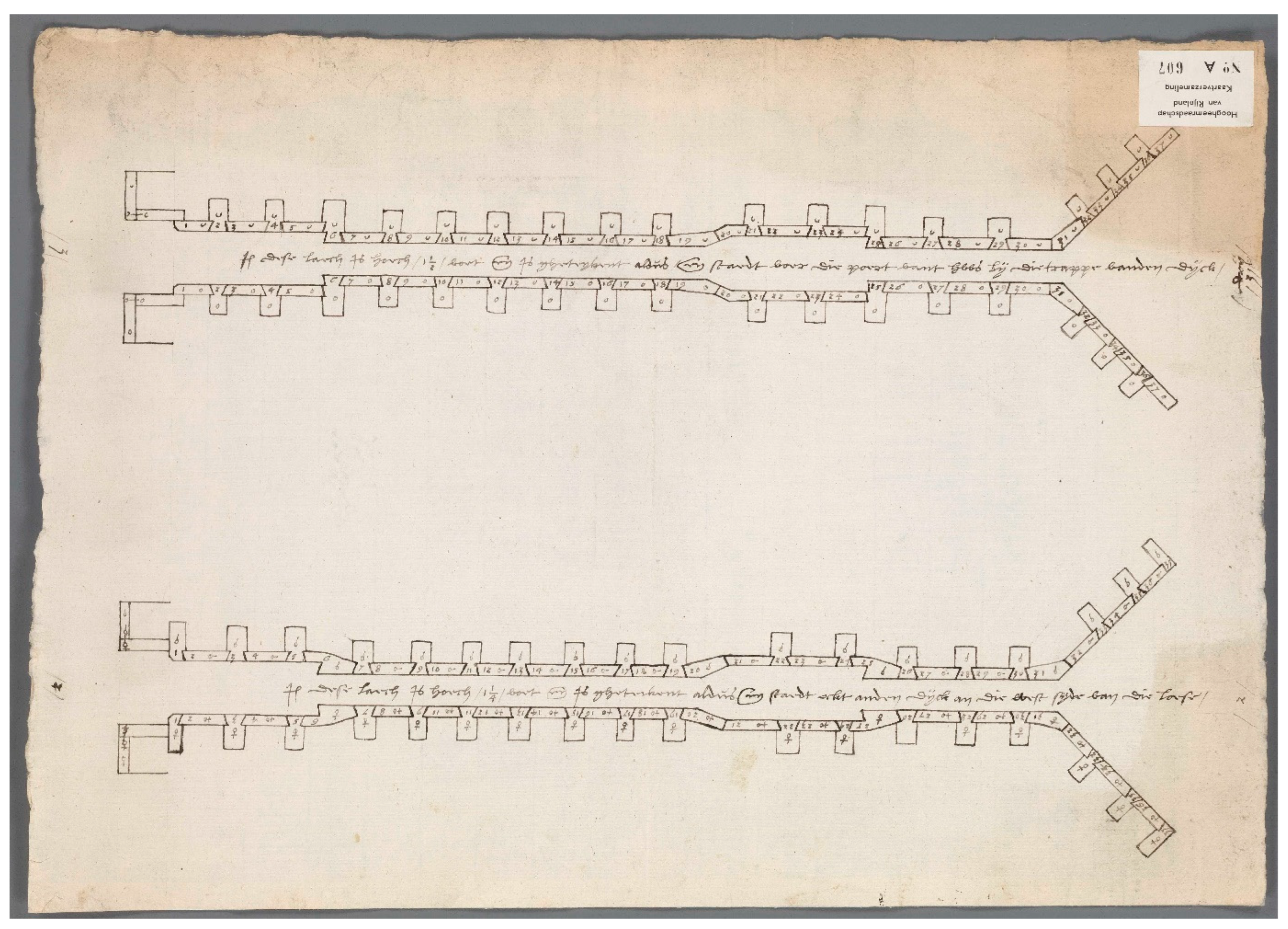
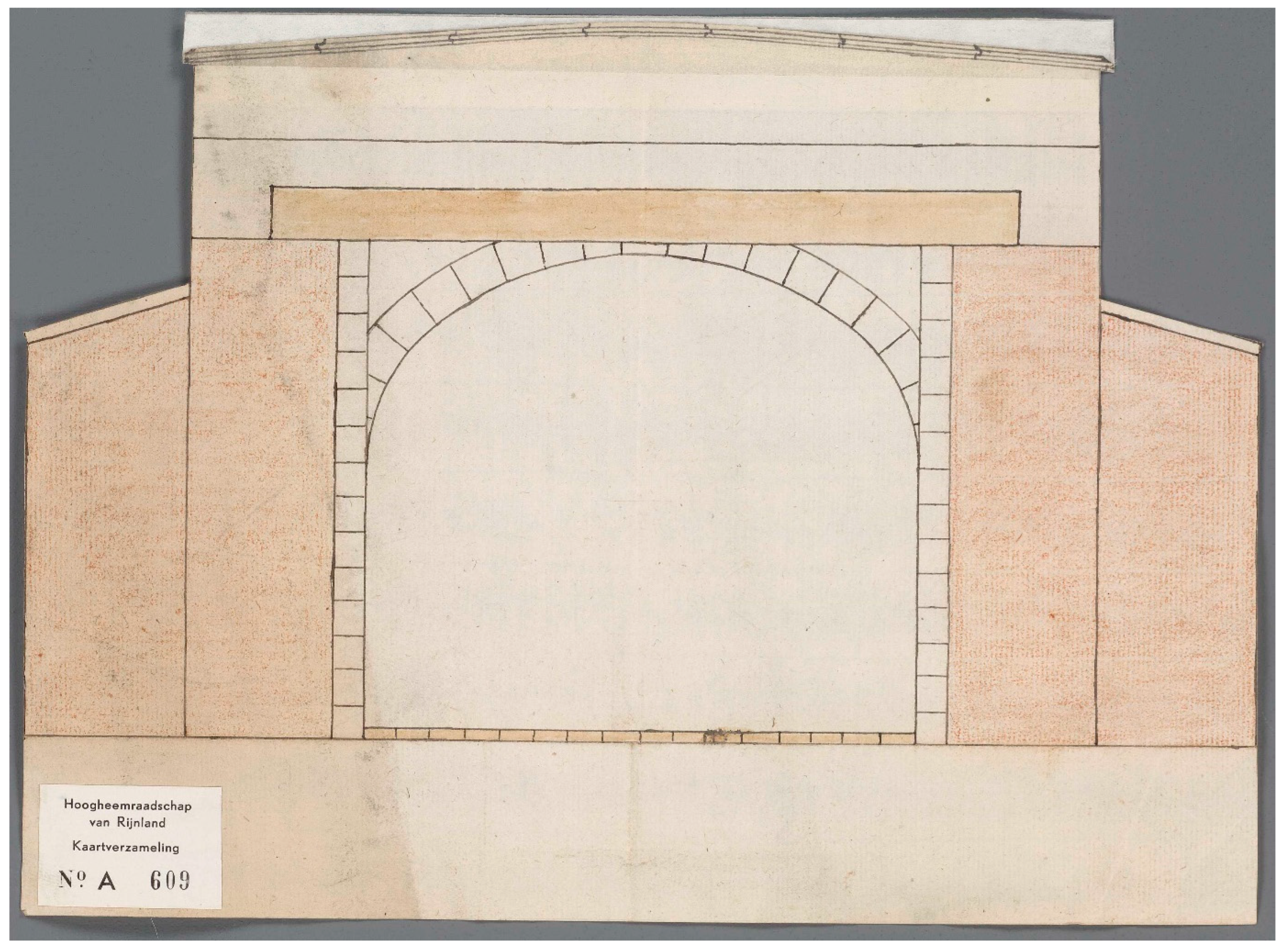
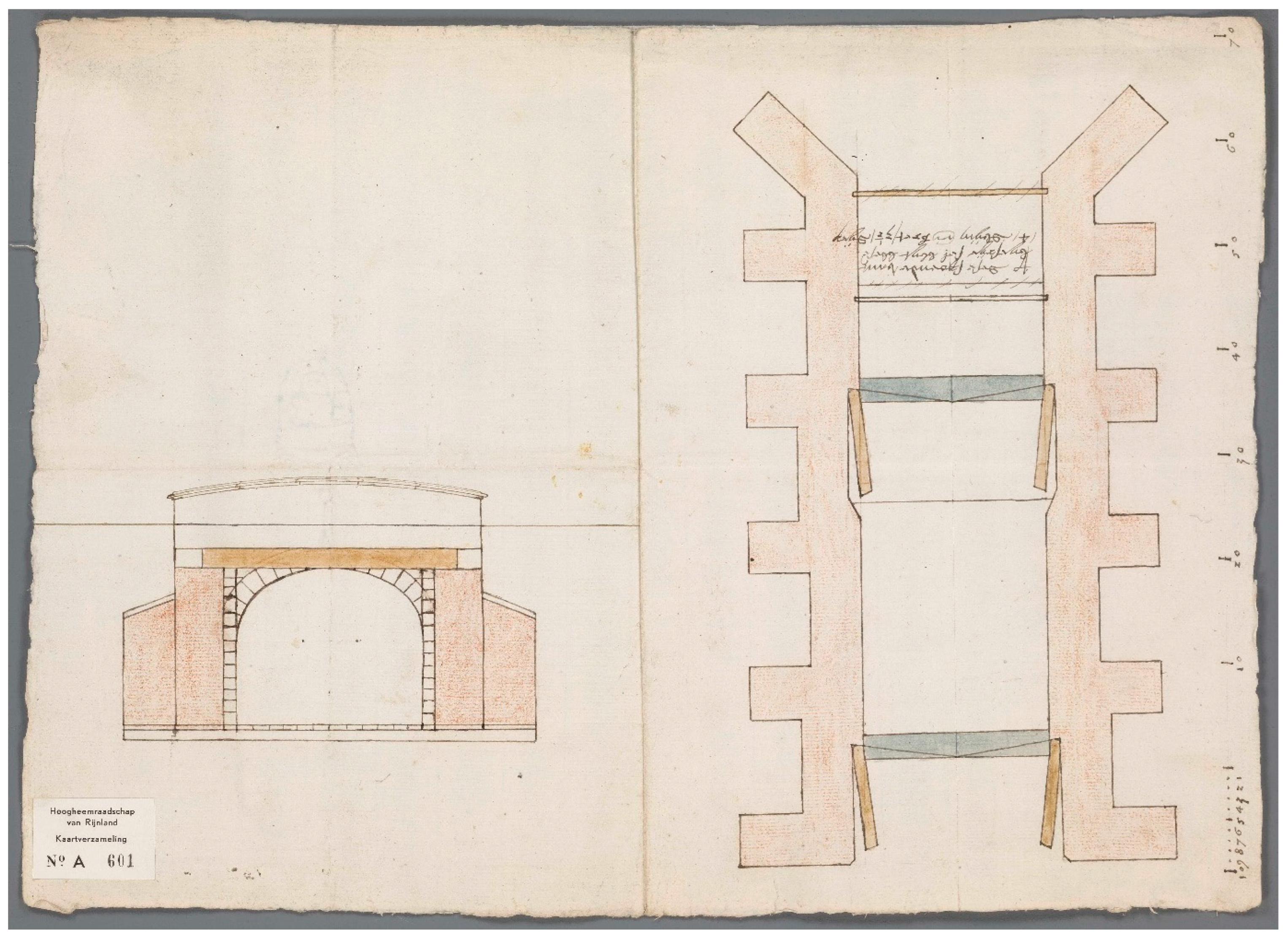
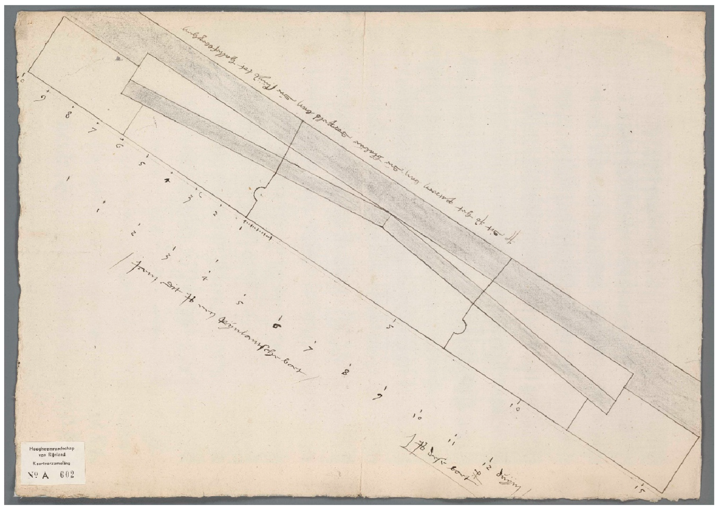
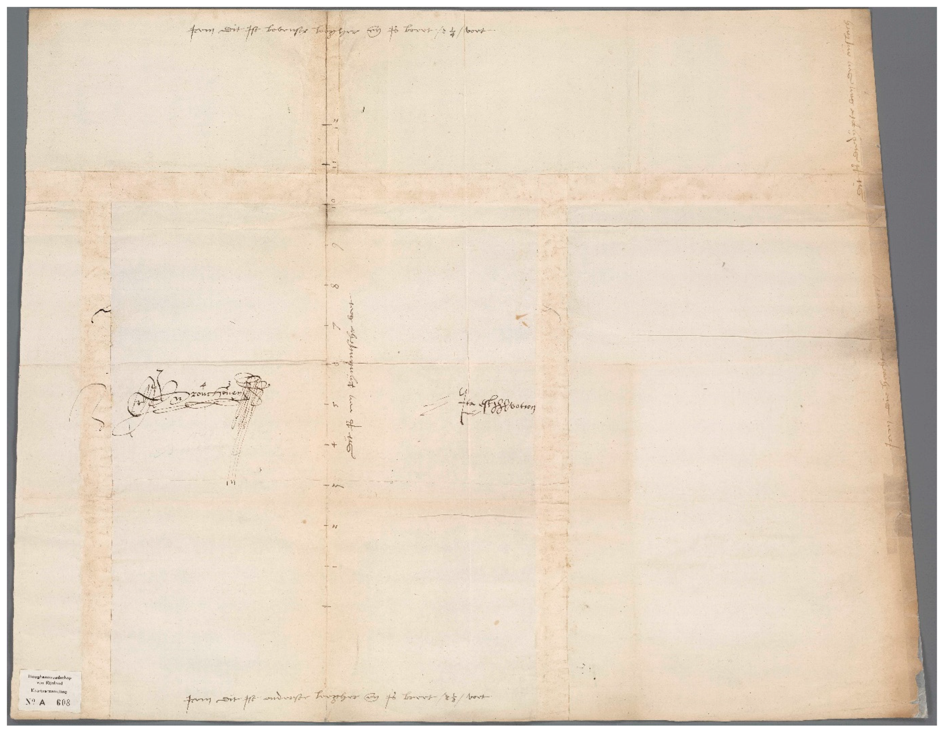
The preserved set of drawings includes the map discussed above, three sheets showing the layout of the entire sluice (Figure 24, Figure 25 and Figure 26), two plans for the foundations (Figure 27 and Figure 28), and four sheets with schematic plans that provide an overview of the position of the stone blocks with their respective assembly marks (Figure 29, Figure 30, Figure 31 and Figure 32). Corresponding to the schematic plans with assembly marks, there are also two sheets that depict the arches of the sluice vaults in elevation (Figure 33 and Figure 34). In addition, there are four drawings depicting the elevation of the sluice (Figure 35, Figure 36, Figure 37 and Figure 38), and one sheet that provides a plan and section of the elevation drawn at the same scale (Figure 39). Finally, two detailed drawings survive for the blue limestone sills of the sluice gates (Figure 40 and Figure 41) (Diebels 1986).
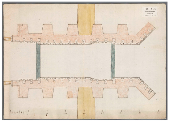
Figure 24.
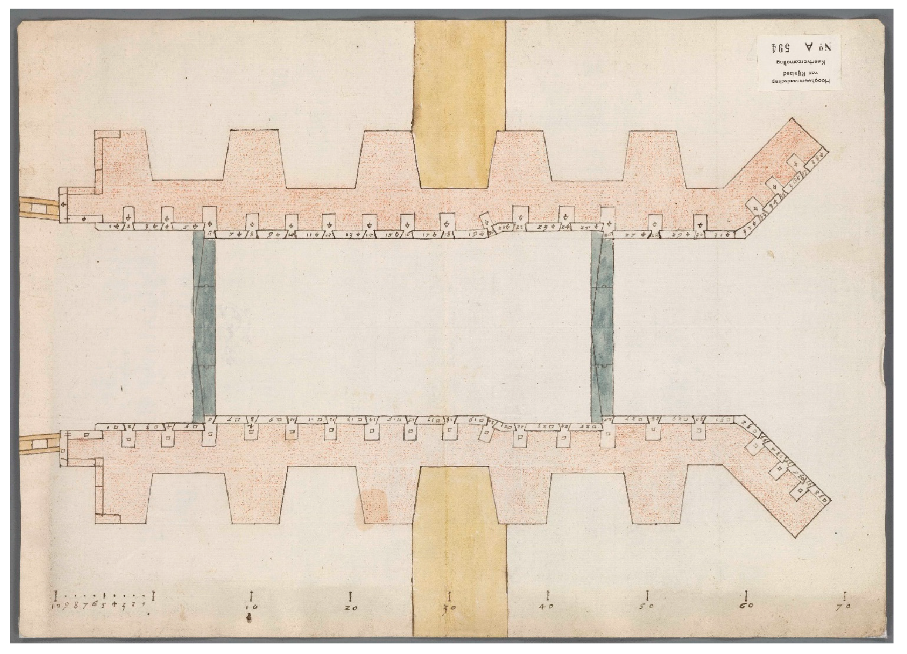
Cornelis Fredericxz vander Goude, final plan of the stone sluice at Halfweg with indicated stonecutters marks and Arabic numbering for the Bentheimer sandstone blocks of the first course, 1557, Oud Archief van Rijnland, Leiden, Collectie Kaarten, A 594 (© NL-LdnHHR).
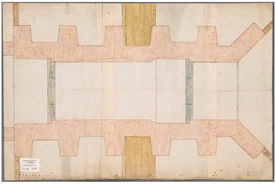
Figure 25.
Cornelis Fredericxz vander Goude, plan of the stone sluice at Halfweg, 1556–57, Oud Archief van Rijnland, Leiden, Collectie Kaarten, A 600 (© NL-LdnHHR).
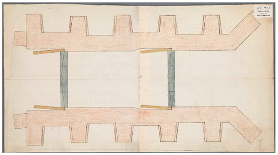
Figure 26.
Cornelis Fredericxz vander Goude, plan of the stone sluice at Halfweg with alternative shapes for the buttresses, 1556–57, Oud Archief van Rijnland, Leiden, Collectie Kaarten, A 606 (© NL-LdnHHR).
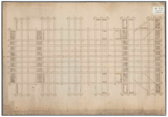
Figure 27.
Cornelis Fredericxz vander Goude, plan of the foundations of the Westsluis, 1556–57, Oud Archief van Rijnland, Leiden, Collectie Kaarten, A 598 (© NL-LdnHHR).
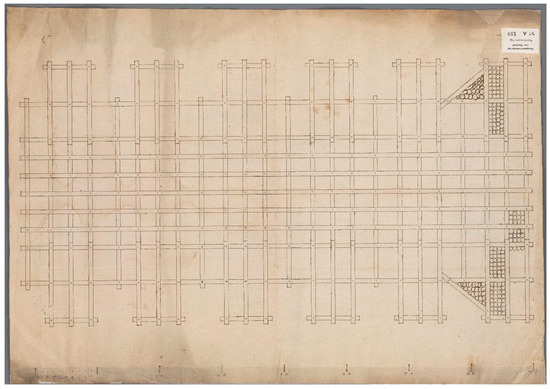
Figure 28.
Cornelis Fredericxz vander Goude, plan of the foundations of the stone sluice at Halfweg, 1556–57. (Oud Archief van Rijnland, Leiden, Collectie Kaarten, A 599 (© NL-LdnHHR).
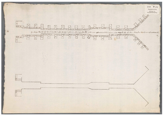
Figure 29.
Cornelis Fredericxz vander Goude, two schematic plans that provide an overview of the position of the Bentheimer sandstone blocks with their respective assembly marks, the upper plan is for the fifth course, 1557, Oud Archief van Rijnland, Leiden, Collectie Kaarten, A 603 (© NL-LdnHHR).
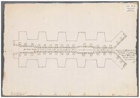
Figure 30.
Cornelis Fredericxz vander Goude, schematic plan of the sluice that provides an overview of the position of the Bentheimer sandstone blocks for the sixth course with their respective assembly marks, 1557, Oud Archief van Rijnland, Leiden, Collectie Kaarten, A 604 (© NL-LdnHHR).
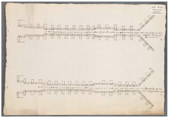
Figure 31.
Cornelis Fredericxz vander Goude, two schematic plans that provide an overview of the position of the Bentheimer sandstone blocks with their respective assembly marks, the upper plan is for the seventh, the lower one for the fourth course, 1557, Oud Archief van Rijnland, Leiden, Collectie Kaarten, A 605 (© NL-LdnHHR).
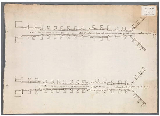
Figure 32.
Cornelis Fredericxz vander Goude, two schematic plans that provide an overview of the position of the Bentheimer sandstone blocks with their respective assembly marks, the upper plan is for the third, the lower one for the second course, 1557, Oud Archief van Rijnland, Leiden, Collectie Kaarten, A 607 (© NL-LdnHHR).
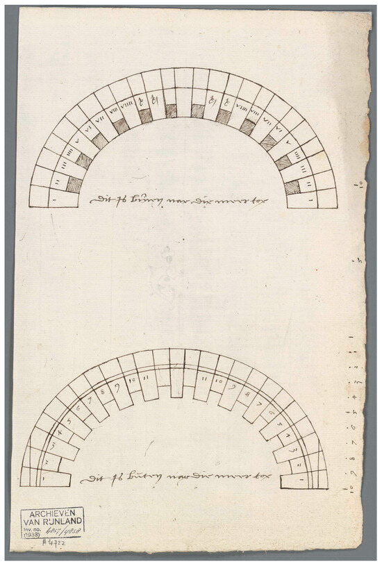
Figure 33.
Cornelis Fredericxz vander Goude, elevation of the stone arches the vaults of the sluice chamber on the lakeside, 1557, Oud Archief van Rijnland, Leiden, Collectie Kaarten, A 4724 (© NL-LdnHHR).
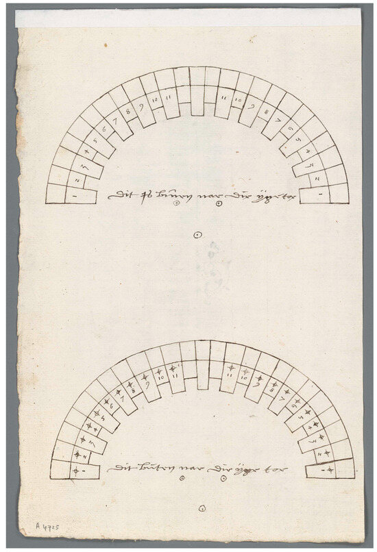
Figure 34.
Cornelis Fredericxz vander Goude, elevation of the stone arches of the vaults of the sluice chamber on the seaside, 1557, Oud Archief van Rijnland, Leiden, Collectie Kaarten, A 4725 (© NL-LdnHHR).
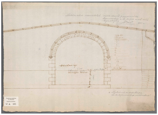
Figure 35.
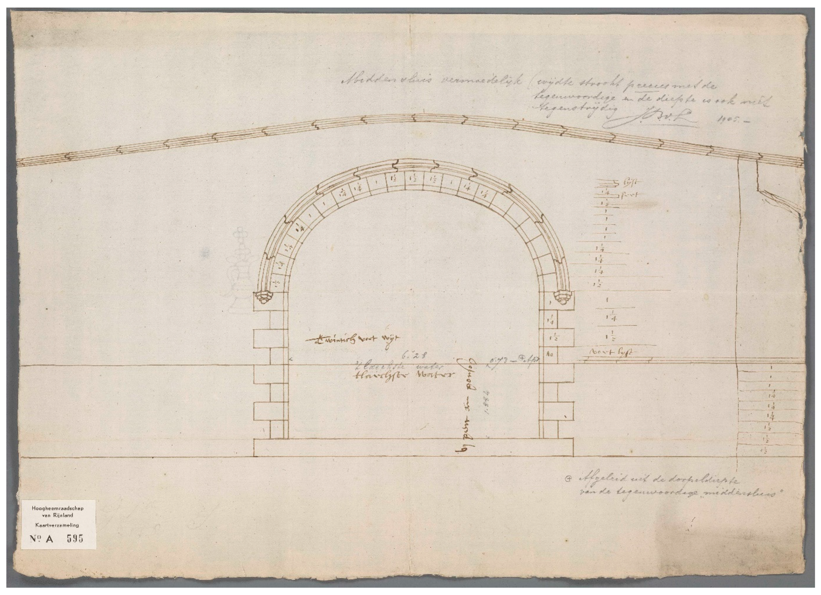
Cornelis Fredericxz vander Goude, elevation of the sluice opening on the north side facing the IJ. The water level at low tide is indicated by a horizontal line and the height of the blocks of each layer of sandstone, as well as the blocks of the arch, are provided, 1556 (?), Oud Archief van Rijnland, Leiden, Collectie Kaarten, A 595 (© NL-LdnHHR).
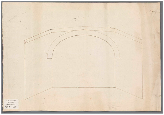
Figure 36.
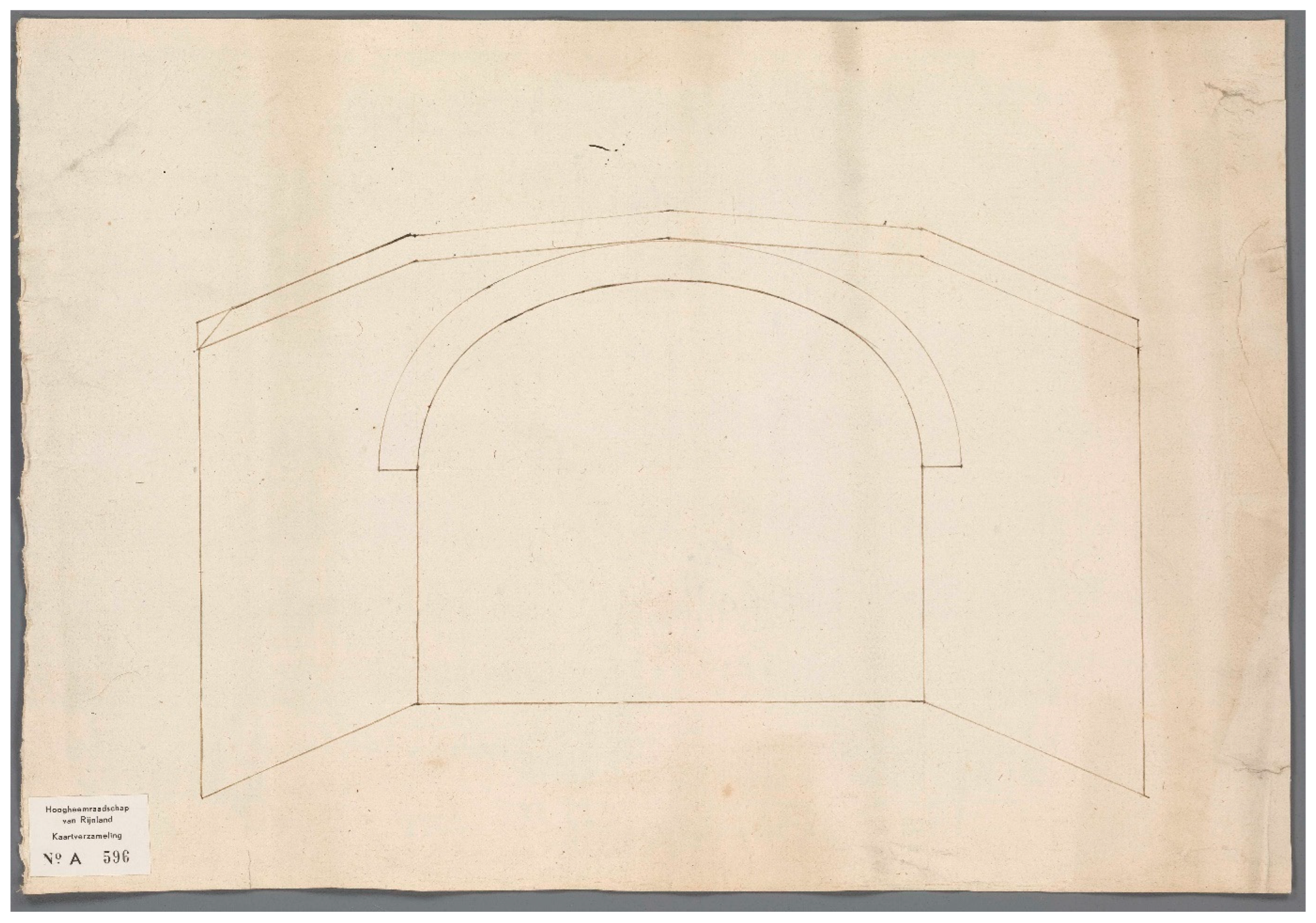
Cornelis Fredericxz vander Goude, schematic elevation of the sluice opening on the lakeside with its oblique buttresses, 1556–57, Oud Archief van Rijnland, Leiden, Collectie Kaarten, A 596 (© NL-LdnHHR).

Figure 37.
Cornelis Fredericxz vander Goude, elevation of the north side facing the IJ, 1556 (?), Oud Archief van Rijnland, Leiden, Collectie Kaarten, A 597(© NL-LdnHHR).
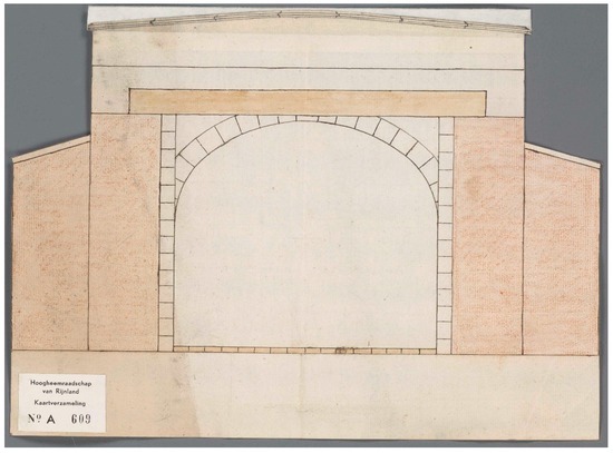
Figure 38.
Cornelis Fredericxz vander Goude, cut-out with the cross-section of the sluice at the point where the gates are mounted. The two lower extensions are the buttresses, 1556–57, Oud Archief van Rijnland, Leiden, Collectie Kaarten, A 609 (© NL-LdnHHR).
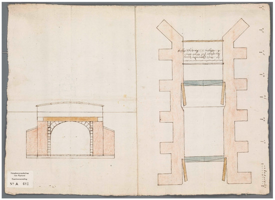
Figure 39.
Cornelis Fredericxz vander Goude, plan and section of the stone sluice, 1556, Oud Archief van Rijnland, Leiden, Collectie Kaarten, A 601 (© NL-LdnHHR).
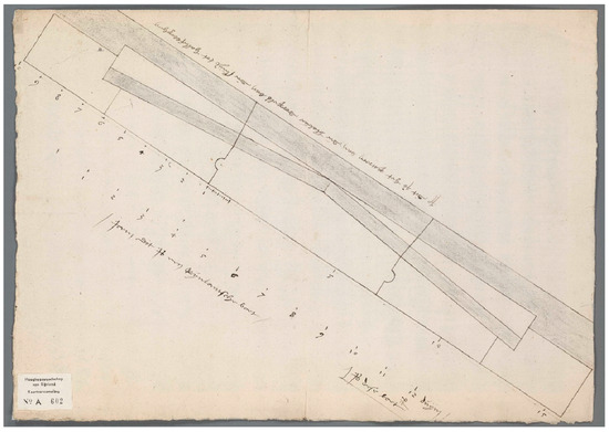
Figure 40.
Cornelis Fredericxz vander Goude, plan of the blue limestone sill of the sluice gates, 1557, Oud Archief van Rijnland, Leiden, Collectie Kaarten, A 602 (© NL-LdnHHR).
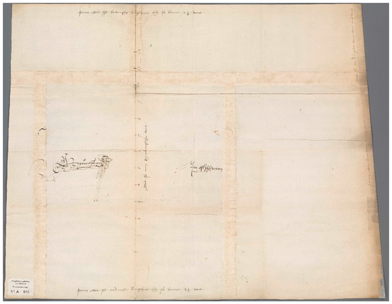
Figure 41.
Cornelis Fredericxz vander Goude, section of the top part of the blue limestone sill, 1557, Oud Archief van Rijnland, Leiden, Collectie Kaarten, A 608 (© NL-LdnHHR).
The drawings share two important features. All plans, apart from three schematic plans with the assembly marks (folios A 603, 605, and 607; Figure 29, Figure 31, and Figure 32) and one full plan (A 606, Figure 26), carry a scale bar based on units of 10 Rhineland foot (31.4 cm). This also applies to the drawing combining plan and section (A 601, Figure 39) and the elevations of the blocks of the arches. Scale bars are also indicated on the plan and section of the sill (Figure 40 and Figure 41). The first has a scale bar with units of 10 Rhineland feet next to the three large blocks of the sill, with one unit divided into feet, and one foot of which is further subdivided into 12 thumbs. Another bar of 12 thumbs is depicted on a 1:1 scale as explained by a note on the drawing. As each region or city in the Low Countries had its own measurements, this indication ensured the right dimensions were applied since the blocks were cut far away from the building site at quarries near Namur in the Southern Low Countries. A similar 1:1 scale bar of a single Rhineland foot divided into 12 thumbs is depicted on the section of the sill.
A second interesting characteristic shared by multiple drawings is that colour is used to indicate the different materials. Red is used for brick, grey for blue limestone, and ochre for wood, while Bentheimer sandstone—which has a sandy white–yellow colour when freshly extracted from the quarry—is left blank.
The layout of the entire sluice is depicted by four plans—one of which (A 601, Figure 39) is combined with a section of the elevation—that show its masonry body of brick along with the blue limestone sills. They look very similar, but small differences can be observed. For instance, drawings A 601 (Figure 39) and A 606 (Figure 26) include the mitre gates, while A 594 (Figure 24) and A 600 (Figure 25) show the sills only. Vice versa, A 594 and A 600 depict the wooden breakwaters, made of piles and planks, that are connected to the sluice’s heads, while they are absent from the other two plans. A 594 also depicts the blocks of Bentheimer sandstone with their respective markings. Interestingly, the four plans also provide slightly different designs for the buttresses and the position of the mitre gates: The combined plan and section (A 601) depicts buttresses with a rectangular plan, while A 606 visualises a search for the right shape by showing a rectangle and of two trapezia overlapping each other. The other two plans have trapezium-shaped buttresses. All plans have diagonal buttresses for the sluice’s head end on the lakeside, but they show slightly different solutions for the buttresses of the sluice’s head end facing the sea: A 601 has no buttresses at all, A 594 and A 600 have buttresses in line with the wall as reinforcement, while those of A 606 are placed at a slight diagonal.
The position of the mitre gates also deserved further analysis: the first gates (voordueren), on the seaside, are all in the same position, just before the second lateral buttresses. However, in A 601 and A 606, the distance between the two gates is smaller. Here, the second gates (achterdeuren) are situated at the fourth buttress counted from the seaside, while on the other two drawings, they are placed before the fifth buttress. These minor differences probably stem from the wish to improve the anchoring of the sluice to the body of the dike and to enhance the flues of the water running through the sluice chamber. Considering these optimisations, the drawing with the rectangular buttresses A 601 was likely made first and can possibly be identified with the ground plan and elevation that Fredericxz made upon his first inspection of the site in June 1556. It was likely followed by the drawing showing the adjustments for the buttresses A 606, and as A 594 and A 600 are close in design, they were probably made later when much of the design was settled. This sequence is supported by the fact that A 594 has numbered stone blocks and must have been drawn at the end of the building season in 1557, when the cutting of the stone was finished, and the blocks were stored near the sluice to be used during the new building season in the spring of 1558, as will be discussed below. At this stage, the design of the sluice was largely finalised.
The four plans of the sluice are accompanied by two plans for the pile foundations (Figure 27 and Figure 28). They show a regular grid that follows the general outline of the sluice. The building specifications that accompanied the foundation plans explain that all of the grid’s squares, called “spaces or holes” (camers oft ghaten), were to be filled with alder piles measuring 24 feet (about 7.5 m) or longer. Extra care was to be given to the squares at the grid’s outer edges and to the squares that supported the limestone sills, in which the piles were to be driven extra tightly together (OAR, 1.1.1, inv. no. 9579d; Hurx 2022, p. 291). It is not clear why the two nearly identical drawings of the pile foundations were made, as the only obvious difference between them concerns the position of the piles. The plan provided on folio A 599 (Figure 28) shows only a few squares at the right that are filled in with piles, where they were to support the oblique buttresses that pointed towards the Spieringmeer in the south. By contrast, on A 598 (Figure 27), there are several squares that have piles only at their outer edges, while four strips of piles are drawn at the very extremities of the grid and at the spot where heavy blue limestone sills support the mitre gates. However, the sill of the second gates is not exactly at the right position because the piles suggest that the sill is perfectly aligned with the buttresses, while on the plans, the sill is placed just in front of them. It is unclear if the two plans were made before or after A 594 and A 600, but it is also possible that they were drawn when the exact position of the foundations was discussed in April 1558.
In addition to the plans, several elevation drawings were made. Folios A 595 (Figure 35) and A 597 (Figure 37) present the elevation of the north side facing the IJ. They resemble each other: The first drawing shows a sluice opening, while the second drawing displays the opening flanked by two wide masonry walls that are topped with copings. The three-centred arch of the sluice is decorated by a moulding that is supported by two Gothic corbels. None of the plans show that a wide brick wall was intended to surround the sluice’s opening. Therefore, this drawing could represent a plan that was rejected early on, possibly because of its high costs. A 595 contains a note explaining that the width of the sluice opening is 20 feet and indicates the water level at low tide by way of a horizontal line 6 feet above the bottom of the sluice chamber. This corresponds very well with the mention in the accounts that the plan of the sluice was set out in the building pit 7 feet below the waterline. Remarkably, the height of the stone blocks for each course and the sizes of the blocks of the arch are provided; the latter are probably measured according to the lower curvature of the arch. The blocks were not drawn to scale, since they are shown as equal in size, contrary to the notes that explain that there were three different sizes: 1 foot, 1.25 feet, and 1.5 feet high. On the right of the opening, there is a schematic representation of the height of the blocks from the bottom to the moulding at the top of the arch.
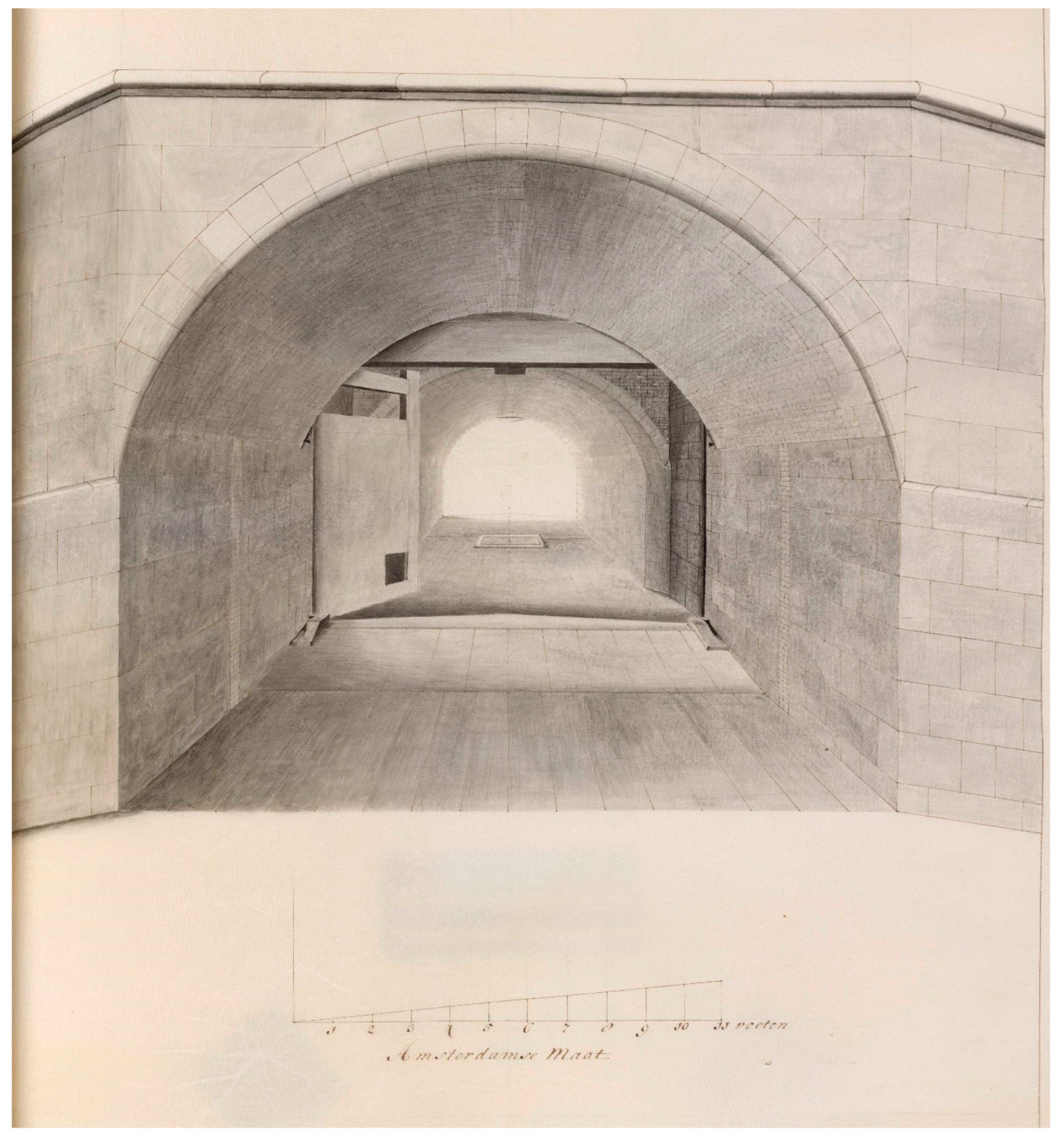
A 596 (Figure 36) provides a schematic elevation of the sluice’s lakeside with its oblique buttresses, the appearance of which is confirmed by an 18th-century perspective drawing for a large-scale renovation of the sluice, which, by that time, was known as the “West sluice”. The drawing was made in 1727 by Cornelis Velsen (Figure 42), an important hydraulic engineer in the service of the Rhineland Water Board.12 It provides a view into the sluice chamber from the south, showing the second mitre gates and the oblique buttresses. A noticeable difference between these two drawings and the elevations of the north side of the sluice is that the arch at the lakeside directly touches the copings at the top, while the top at the seaside is taller.
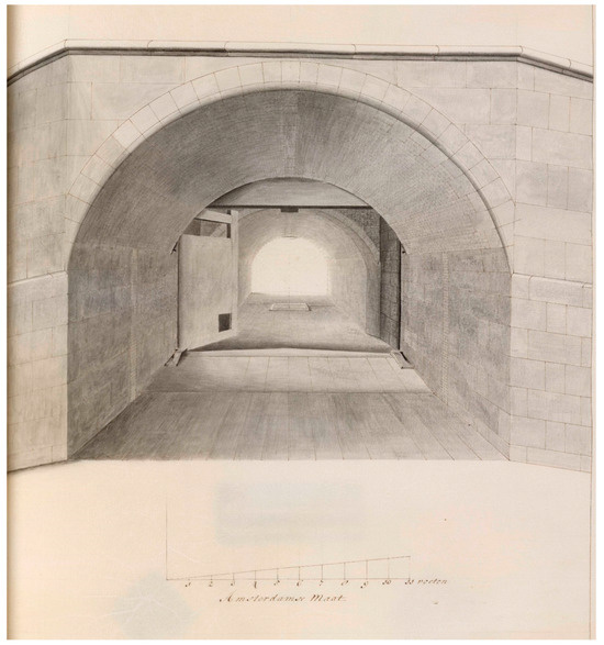
Figure 42.
Cornelis Velsen, view of the opening of the “West sluice” on the lakeside, in: Tekeningen, vande Rhynlands sluysen. gelegen by ‘t Huys te Zwaanenburg of vande reparatie aan dezelve gedaan inde jaaren 1725, 1726, en 1727, unpublished manuscript, fol. 9, 1727, Oud Archief van Rijnland, Leiden, Collectie Kaarten, A 4804 (© NL-LdnHHR).
A 601 (Figure 39) and A 609 (Figure 38) provide a cross-section of the structure at the point where the gates are mounted. A 609 is a cut-out, while the section on A 601 is combined with a plan on the same scale. This is a remarkable early example of a systematic orthographic combination of elevation and plan (Hurx 2020). Both drawings only show what lies on the surface of the projection: for example, the wooden upper beam is missing from the floor plan. Although the plan does not have a mark indicating where the section was taken, this can be deduced from its position with respect to the plan: the bottom of the section is exactly in line with the bottom sill of the gate. There was no vault there because it would have obstructed the movement of the gates (see Figure 42). When the gates closed, they slammed against the sill at the bottom and against a thick wooden cross-beam at the top, both of which were intended to prevent them from collapsing under the pressure of the water. The cross-beam is visible in both sections as an ochre horizontal beam that runs in front of the top of the arch. Also noticeable in both drawings are the two lower elements in red that flank the walls of the sluice, which are the sluice’s buttresses.
7. A Graphic Parts List for Stone
A distinct set of drawings within the whole set comprises the five plans of the sluice and the two folios with elevations of arches, in all of which the Bentheimer sandstone blocks are marked and numbered. These are unique, and no comparable drawings that comprehensively list all stone elements exist. We can be sure that these drawings were made by Fredericxz himself as a note on A 604 mentions that the stone was stocked in front of “the [masons’] lodge where I work” (die loese daer ic inverick). They are reminiscent of the illustrated lists of parts found in modern instruction manuals, which guide the user through the assembly of an object. Plan A 594 (Figure 24) shows that the stone cladding consisted of toothed blocks, with thin plates alternating with blocks fitted deeper into the brickwork. Each block received a number and a mark to distinguish the west and east walls of the sluice.13 Numbering started on the north side, and each course consisted of 39–40 blocks, including the two unnumbered parts for the buttresses of the sluice head facing the IJ. The blocks alternated per course, ensuring a well-bonded masonry. Notes written by Fredericxz specify the height of the blocks for each course, while the Arabic numerals placed at the edges of each sheet (Figure 29, Figure 30, Figure 31 and Figure 32) prescribe the order in which the seven courses had to be assembled.14 Only the first course, depicted in plan A 594, is not specified by a number.
While assembly marks were commonly used in the late Middle Ages in the Low Countries for architectural features in stone, such as cross-windows or columns, no comparable elaborate system of markings for an entire structure survives. The only contemporary and comparably methodical notation systems are those for timber roof structures, which usually provide numbers for each truss and combine them with pair marks where the truss’ components were put together. For timber roofs, no drawings survive that mark each of its components. Graphic aids that provide visual information on the components of a building or part of a building were obviously very useful as a mnemonic device, and, therefore, it seems likely that the drawings for Halfweg were not unique, although none survive. However, the systematic approach of Fredericxz seems also to have been born out of circumstances. The plans, together with the elevation for the sluice head of the north side that indicates the height of the blocks (A 595, Figure 35), reveal that the bonding of the stone blocks was of great consequence. Water ran through the sluice chamber with great force, and the joints had to fit perfectly to prevent water from infiltrating the masonry. However, that does not fully explain the careful preparation of so many drawings. The notes on the schematic plans provide an important clue for their making: they explain that the blocks for each course were systematically piled up near the sluice. For instance, the blocks of the course at the sixth level (A 604, Figure 30) were stored in front of the masons’ lodge, while other heaps of ready-made stone were stacked at the gate of the Gemeenlandshuis, at the dike near the old sluice, and in other locations. This was caused by the unforeseen halt in construction due to the subsiding dam of the building pit in May 1557. Consequently, all the stone cut in the summer of 1557 could only be assembled a year later and had to be stored for the winter. The drawings were meant to help sort the stone when the workmen returned.
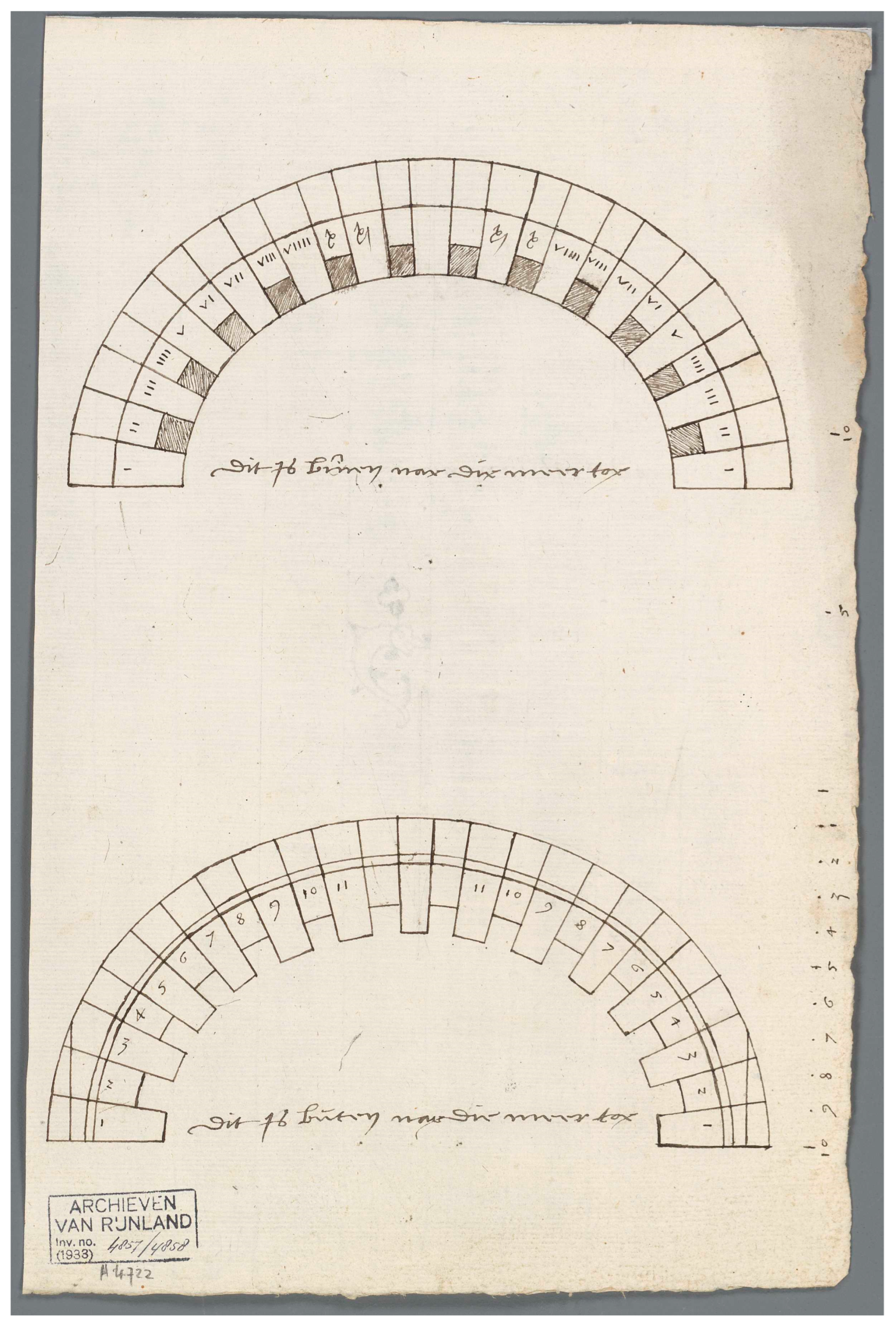
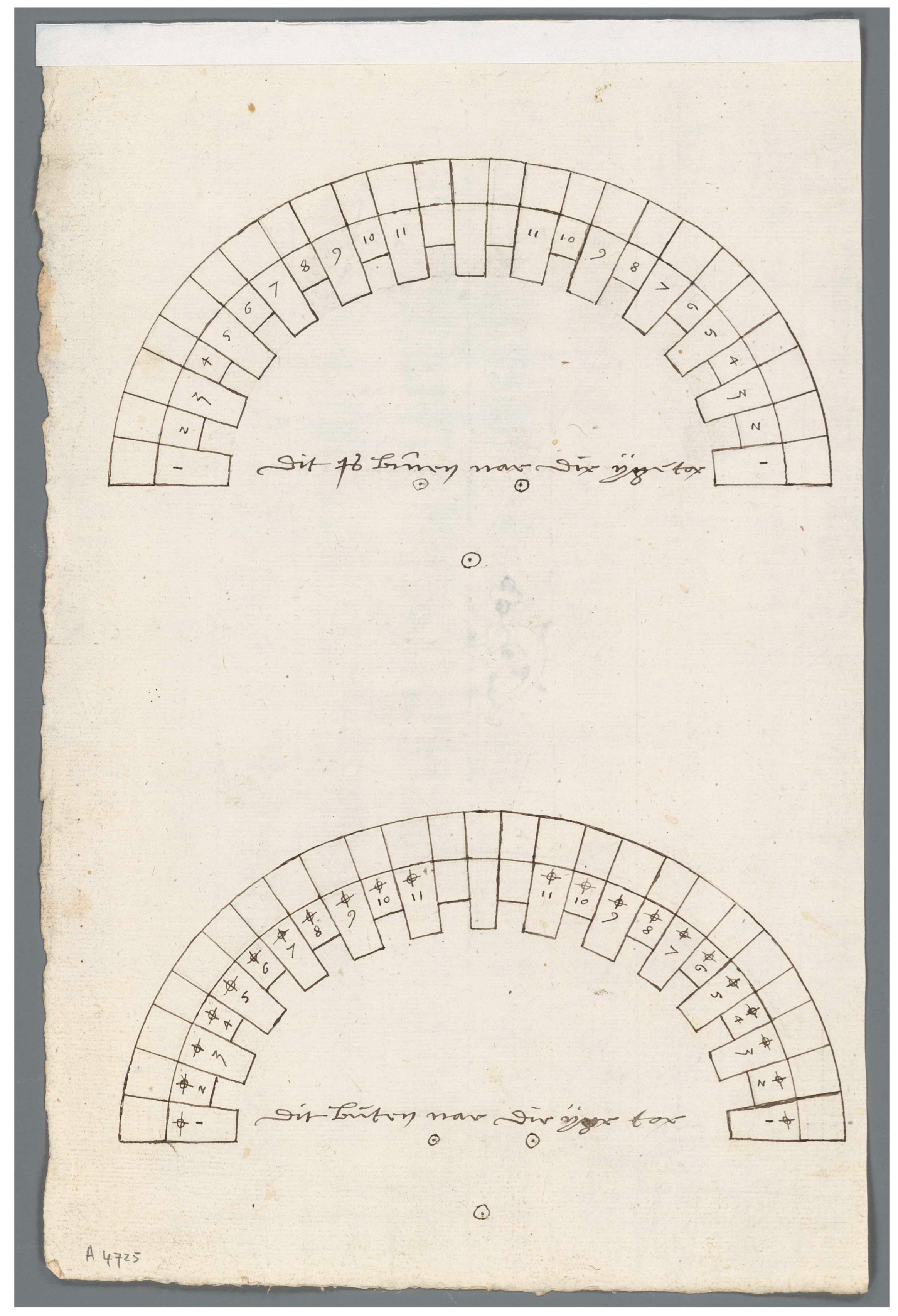
Similar drawings were made for the stone blocks for the arches of the barrel vaults of the sluice chamber. One sheet of paper (A 4724, Figure 33) depicts two three-centred arches—the three points of the compass are clearly visible—for the vault on the lakeside: below is the exterior arch (buten nae die meer toe) and above the interior arch (binnen nae die meer toe). The other drawing on folio A 4725 (Figure 34) depicts the corresponding arches at the other end of the sluice, facing the IJ. All the blocks were provided a number (1 to 11), except for the three blocks at the apex of the arch, which were probably made to fit to complete the arch once all the blocks had been placed on the centring. A distinction was made between Roman and Arabic numerals for the lakeside, while a mark was added to the exterior arch for the seaside to discriminate between the interior and exterior arches. The toothing of the blocks is not easily understood from the two drawings: it looks as if the arches are composed of an outer and an inner arch, but in reality, they depict two different sides of the same blocks: a frontal view in orthogonal projection is here awkwardly combined with a bottom view in some sort of perspectival projection. This can be understood from the perspective drawing by Velsen (Figure 42), which shows that the stone blocks were toothed with the bricks of the vault to provide a proper bonding. This means that the numbers on the drawing are indicated on the bottom of the blocks.
A remarkable feature of drawing A 4724 is its scale bar, which seems superfluous for the purpose of sorting the stone. It probably served the discussion on the vaults’ dimensions when the work reached the bottom level of the vaults. In July 1558, Fredericxz advised the water board that the walls from the bottom up had to be 7 feet high, and the arch 8 feet tall, while the barrel vault itself was to be 2.25 feet thick (OAR, 1.1.1, inv. no. 9578, f. 449r.-v.). In fact, the drawing shows that the distance between the bottom of the springer and the bottom of the keystone is exactly 8 feet. The board followed Fredericxz’s advice for the south sluice head, but he was instructed to make the vault at the other end 12–13 thumbs—the height of a stone block—lower.15 Unfortunately, no explanation for this finetuning is provided by the archival sources.
8. Detail Drawings
Two graphic aids remain for the blue limestone sill of the sluice gates: a plan showing the three blocks of the sill (Figure 40) and a section of the top part of the sill (Figure 41). The plan of the sill, which carries the note “pattern of the blue sills” (patroen van die blauwe dorpels), shows the sill from above. It is drawn diagonally on the sheet to make the most out of the space available. It clearly displays the tongue and groove joints that slot together the blocks. The v-shaped outline is where the sill supports the mitre gates when closed. It has been shaded to show that it has a chamfered edge, the exact angle of which is provided by the section. This cut-out shows the upper part of the sill and provides dimensions written on the paper: at the bottom, it had to be 2.5 feet wide, and at the top, 2.25 feet. Although the section looks like a true template that could be used to trace the shape on a block of stone, it is not: it is not proportioned according to the written dimensions. Rather, the section communicates a general idea of the shape, but the written dimensions had to be followed to cut the block of stone in the right outline.
The blue limestone sills were contracted out in Dordrecht, which was an important harbour town in Holland for goods transported on the river Meuse on 24 May, 1557. The stone merchant Michel Votron, from Namur —which is a town more than 300 km upstream of the Meuse in Hainaut— promised to deliver the blocks readymade at the harbour crane in Dordrecht (OAR, 1.1.1, inv. no. 9578, f. 611r. The contract still survives: OAR, 1.1.1, inv. no. 9579d). Federicxz and the receiver of the water board had travelled to Dordrecht to contract out the sills several times, but at the moment of signing the contract, the master was not present. Instead, 6 days earlier, Federicxz had sent a letter from Halfweg to the water board, specifying the exact length, width, and height of the sills (OAR, 1.1.1, inv. no. 9579d). The designs had been made months earlier, in January, when the drawings (pathroonen) and specifications (bestecken) by Fredericxz were discussed by the water board (OAR, 1.1.1, inv. no. 9578, f. 470r.).
Similar drawings of specific details were made at each building site in substantial quantities, but very few have survived as they were discarded after use. Fredericxz is documented to have made multiple templates both for masons working at the masons’ lodge in Halfweg, as well as for the stone merchants at the quarries near Namur.16 Wooden templates, called “berderen” (scantlings), were provided to stonecutters to outline moulding contours on blocks of stone. In this way, it was ensured that all similar blocks had identical shapes. Fredericxz probably made his templates on paper and then had a cabinet maker cut copies in wood because a cabinet maker is documented to have supplied templates for the stones of the arches at Halfweg: “after which master Cornelis had the stonemasons cut the stones of the arches”.17
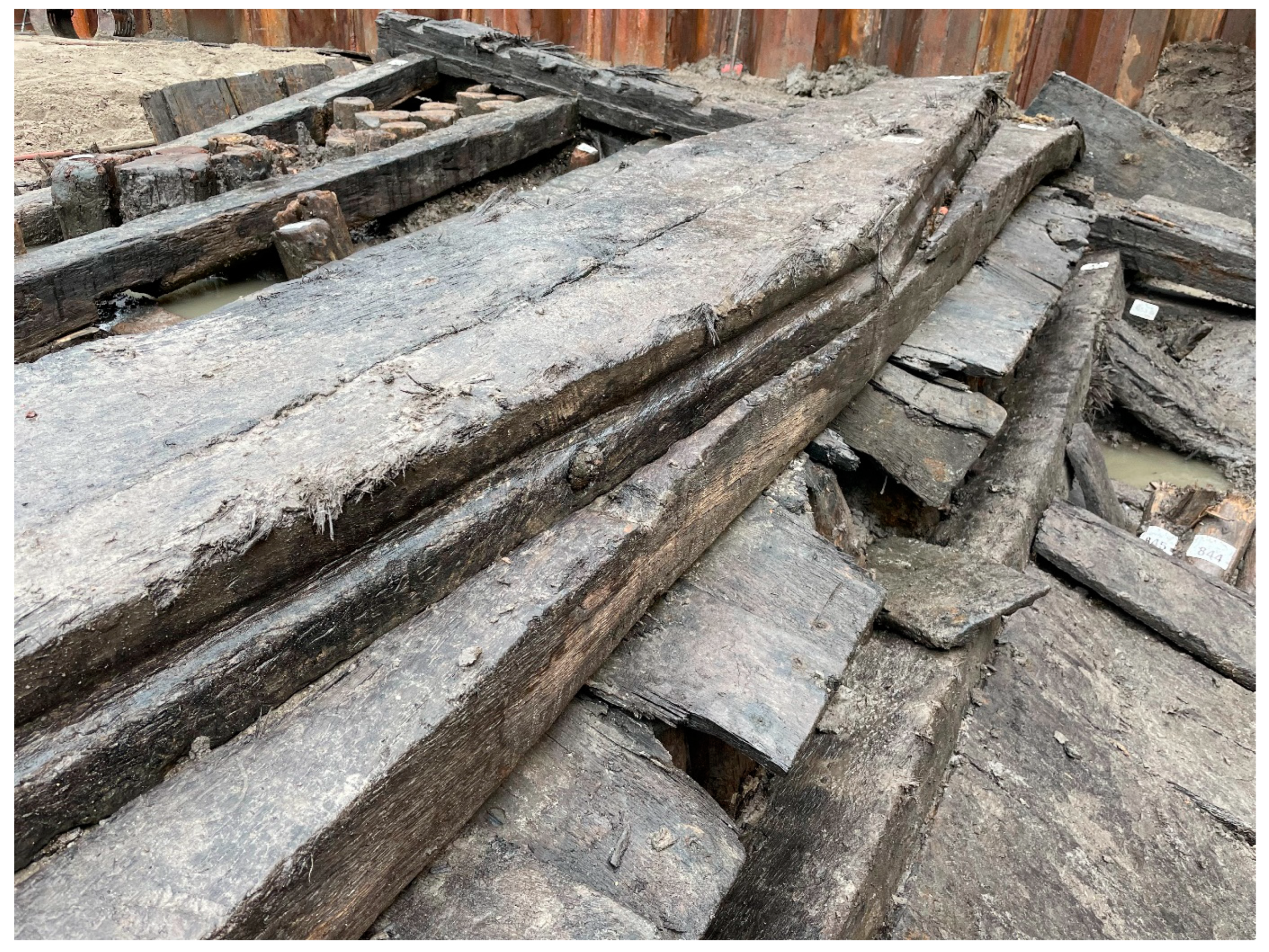
For intricate blocks or components, multiple drawings and templates were needed. This is also the case for the blue limestone sills. Due to their relatively complex shape—which were similar to the sills made of wood for the 16th-century lock at Monnickendam, excavated in 2021 (Figure 43)—it seems likely that, in addition to the plan and section of the sill, other drawings were provided to the stone merchant.18 It was important that the sill fitted perfectly with the doors to ensure good closure: In his letter on the dimensions of the sills, Fredericxz provided the measurements down to half a thumb, which is 1.3 cm—the length of the sill being over 7 m (OAR, 1.1.1, inv. no. 9579d).
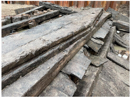
Figure 43.
V-shaped wooden sill for the sixteenth-century lock with mitre gates at Monnickendam, 1565–67, excavated in 2021. (© author).
9. Conclusions
This meticulous study of thirty drawings made for two locks and a sluice in the Netherlands in the mid-sixteenth century leads to several conclusions that have wider implications. The design and construction of such hydraulic works were highly complex; factors such as difficult soil conditions, the force and flows of water, the different types of gates, durability, and costs needed to be considered. Planning required painstaking effort and involved the making of a considerable quantity of drawings. Many more drawings were made than is often believed today, even well before the seventeenth century. They directed virtually every step of the design and building process: from gathering information and discussing the most suitable location and design to guiding the stonemasons in the execution of the work. Multiple types of drawings were produced: “maps” or bird’s eye views, plans, elevations, and full sections as well as technical detail drawings. A key observation is that, although the fully preserved accounts of the Rhineland Water Board document multiple payments for drawings related to the sluice in Halfweg, based on the written evidence, the large number of drawings that has been preserved is completely unexpected. This suggests that archival sources are not a reliable indicator for determining the extent of drafting, as they do not accurately reflect actual practice.
Another significant conclusion is that hydraulic works belonged to the realm of architecture. The designers involved in the construction of these three sluices were all prominent master craftsmen employed either by a major city (Utrecht, Amsterdam) or the church (St. John’s in Gouda). These masters worked on all sorts of buildings since a distinction between civil engineering and architecture did not exist at that time. Equally anachronistic is the differentiation, found in present-day literature, between master craftsmen trained in the Gothic tradition and “true” renaissance architects. In reality, the boundaries between the two categories were much more fluid and porous. The master craftsmen involved in the design of the three sluices were eager to pick up Vitruvian concepts. Just two decades after Pieter Coecke van Aelst published the first excerpt of his treatise in Dutch in Antwerp (1539), Reynier Corneliszn, the city architect of Amsterdam, signed one of his letters to the Rhineland Water Board with “architect”. Similarly, Heinric van Noort was called “stads architekt” in Utrecht. It is also telling that Van Montfoort used Vitruvian terminology for different types of projections and Latin to indicate the unit of length, although he did not apply the projections as systematically. This evidence demonstrates that these master masons and carpenters were early adopters of Renaissance concepts, even if they did not frequent the humanist circles of the Habsburg court in Brussels.
The drawings also show that masters trained in the Gothic style employed a variety of drafting methods. They engaged with new design techniques, using scale, colour, and multiple views to convey all aspects of a project. Another noteworthy novelty is the use of three-dimensional-models for the planning of sluices. As these mid-sixteenth-century examples belong to the earliest recorded wooden models in the Low Countries, hydraulic engineering may have encouraged their use in architectural practice, rather than the other way around. This indicates that changes in style and method were not always interrelated, and demonstrates that the Gothic roots of this generation of masters did not make them inherently traditional.
Funding
The research for this paper is funded by the European Union. Views and opinions expressed are however those of the author only and do not necessarily reflect those of the European Union or the European Research Council Executive Agency. Neither the European Union nor the granting authority can be held responsible for them. This work is supported by ERC grant URBAN-DELTA DOI: https://doi.org/10.3030/101124701, accessed on 21 September 2024.
Data Availability Statement
All data from archival sources in this study are available in public archives.
Acknowledgments
My thanks goes to Anthony Gerbino for his suggestions for the title of this paper.
Conflicts of Interest
The author declares no conflict of interest.
Notes
| 1 | A similar development can be discerned in 15th- and 16th-century Italy. Schlimme et al. (2014, p. 325). |
| 2 | Ottenheym and De Jonge (2007, pp. 93–96). Little is known about Mockaert, before he entered into the service of the Brabantine court in 1556, but he supplied stone for the Coudenberg Chapel in 1552. Archives générales du Royaume, Brussels, Chambre des Comptes, 4255, f. 180v. and Archives générales du Royaume, Brussels, Cartons, 132a. See also Roobaert (2004), 26. And in 1550 he was one of the expert advisors on the design of the Coudenberg Chapel, while also later he was consulted for the Antwerp Town Hall in 1564, for which he also had supplied pilasters two years earlier. Adriaenssens (1980, pp. 123–42) and Hurx (2023b, pp. 20–21). |
| 3 | Dodt van Flensburg (1843, vol. 3, p. 249). His father already provided a design in 1535 and in 1553, however works only began after a new drawing was made by Heinric. Dodt van Flensburg (1843, vol. 3, pp. 217 and 229). |
| 4 | … een van de beste Meesters in Hollandt van deze Conste te wesen die gelijcke wercken wel gemaict heeft… Thijssen (2001, p. 7). |
| 5 | Willem van Noort was appointed as stads-metselrie-meester in 1540. Dodt van Flensburg (1843, vol. 3: p. 220). |
| 6 | …overmidts dien datmen egheene sulcke wercken gemaken en can, ten sy datter yerst ennich beworp oft patroon af geordineert sij, daer na men die wercken mach (one cannot erect such a construction, unless there is devised some sort of design or pattern, after which the work can be made…). Hurx (2018, p. 43). |
| 7 | A typical category of combined drawings is that of sacrament houses. Such drawings have been preserved in the German world from the 15th and early 16th century in substantial numbers. Böker (2005, p. 25). Also in Britain the combination of plan and elevation was known, see: Gerbino and Johnston (2009, p. 30). |
| 8 | …omme te onderzoucken den grondt ende de bequaeme gelegenth. vandien ende alle tzelve by geschrifte gestelt mitsgaders noch aldaer gemaect ende ontworpen eende charte ende patroon daer naer men de voors. sluse zoude mog. funderen ende dat gedaen wesende miter zelve besoingne weder gereyst ind Hage. OAR, 1.1.1, inv. no. 9578, f. 463r.-v., and …ghemaect heeft een grondt ende besteck in pouirtracture van de zelfve sluse… OAR, 1.1.1, inv. no. 9578, ff. 603r.-604r. |
| 9 | In 1557, Fredericxz was paid for een cairte van die gheleghentheyt van de sluse in de groote wale… while also the painter Roeloffs received payment for a map in July 1557, which was referred to in almost the same words …cairte vande gelegentht. vande sluys inde grote waele met hoeren tochten ende aenwateringhen... OAR, 1.1.1, inv. no. 9578, f. 19r. and f. 610v. Possibly they worked together on the same map. See also Van Amstel-Horák (1994, p. 49); Diebels (1986, pp. 19–21). |
| 10 | OAR, 1.1.1, inv. no. 21, f. 18r. The initial the estimated cost of July 1556 was 6000 pounds (of 40 groats Flemish). OAR, 1.1.1, inv. no. 21, f. 19v. See also Van Amstel-Horák (1994, p. 62). |
| 11 | …berderen ende winckelhaicen dair Mr. Cornelis de boochstucken heeft doen nae houden… OAR, 1.1.1, inv. no. 9579d. See also OAR, 1.1.1, inv. no. 9578, f. 201v. |
| 12 | Cornelis Velsen, Tekeningen, vande Rhynlands sluysen. gelegen by 't Huys te Zwaanenburg. of vande reparatie aan dezelve gedaan inde jaaren 1725, 1726, en 1727, 1727. OAR, 1.1.1, inv. no. 30A Kaarten en technische tekeningen. See Van Amstel-Horák (1994, p. 69). |
| 13 | Folio A 605 explains that the west side is marked with a “+”: Item dese laech is hoech, 1 ¼, voet ende is gheteikent aldus mit, 1 2 3 4 5 6 7 8 9 10, ende die west sijde met een, +, ende staedt bij die owe sluijs anden dijck. |
| 14 | The height of each course seems not to correspond to sizes mentioned on the elevation drawing A 595. |
| 15 | …een lage steens lager wesen zoude dan twulfsel aen de meer zyde… 9. OAR, 1.1.1, inv. no. 9578, f. 451r. and f. 456v. |
| 16 | For instance, the blue limestone copings were contracted out following the templates of Fredericxz: navolgende de voors. barderen ofte patroonen. OAR, 1.1.1, inv. n0. 9581a. |
| 17 | …daer meester Cornelis de boochstucken heeft doen nae houden… OAR, 1.1.1, inv. no. 9578, f. 201v. |
| 18 | The archaeological excavation was done by Vestigia B.V., who gave me access to the site in 2021. My thanks goes to Jeroen Flamman who discussed the excavations with me. |
References
Primary (Written) Sources
Archives générales du Royaume, Brussels,.Cartons, 132a.Chambre des Comptes, 4255.Nationaal Archief, The Hague, Grafelijkheidsrekenkamer, 5008.Hoogheemraadschap van Rijnland, Leiden, Oud Archief van Rijnland, Leiden (OAR), 1.1.1,.inv. no. 21; 4856; 9578; 9579d; 9581a.inv. no. 30A, Kaarten en technische tekeningen.Secondary Sources
- Ackerman, James. 2002. The Origins of Architectural Drawing in the Middle Ages and Renaissance. In Origins, Imitation, Conventions: Representation in the Visual Arts. Edited by James Ackerman. Cambridge: MIT Press, pp. 27–65. [Google Scholar]
- Adriaenssens, R. 1980. Sur l’hôtel de ville d’Anvers et les apports des carrières wallonnes dans son édification. Bulletin de la Commission Royale des Monuments et des Sites 9: 123–42. [Google Scholar]
- Amstel-Horák, Marleen van. 1994. Nieuwbouw van twee sluizen in een benarde tijd: Halfweg 1556–1558. In Zeven eeuwen Rijnlandse uitwatering in Spaarndam en Halfweg. Van beveiliging naar beheersing. Edited by Ludy Giebels. Leiden: Uitgeverij Verloren, pp. 47–74. [Google Scholar]
- Arends, G. J. 1994. Sluizen en Stuwen. De ontwikkeling van de sluis-en stuwbouw in Nederland tot 1940. Utrecht: Matrijs. [Google Scholar]
- Berg, Bianca van den. 2008. De Sint-Janskerk in Gouda. Een oude stadskerk volgens een nieuw ruimtelijk plan. Hilversum: Uitgeverij Verloren. [Google Scholar]
- Berg, Herma van den. 1963. Hollandse en Nederrijnse invloeden in de XVde en XVIde eeuwse bouwplannen van de St. Maartenskerk te Tiel. Nederlands Kunsthistorisch Jaarboek (NKJ)/Netherlands Yearbook for History of Art 14: 1–25. Available online: http://www.jstor.org/stable/24705295 (accessed on 1 May 2024). [CrossRef]
- Böker, Johannes. 2005. Architektur der Gotik. Bestandskatalog der weltgrößten Sammlung an gotischen Baurissen (Legat Franz Jäger) im Kupferstichkabinett der Akademie der bildenden Künste Wien/Gothic Architecture. Catalogue of the World-Largest Collection of Gothic Architectural Drawings (bequest Franz Jäger) in the Collection of Prints and Drawings of the Academy of Fine Arts Vienna. Salzburg and Vienna: Verlag Anton Pustet Salzburg. [Google Scholar]
- Böker, Johannes, Anne-Christine Brehm, Julian Hanschke, and Jean-Sébastien Sauvé, eds. 2011. Architektur der Gotik. Ulm und Donauraum. Ein Bestandskatalog der mittelalterlichen Architekturzeichnungen aus Ulm, Schwaben und Donaugebiet. Salzburg and Vienna: Müry Salzmann. [Google Scholar]
- Böker, Johannes, Anne-Christine Brehm, Julian Hanschke, and Jean-Sébastien Sauvé, eds. 2013. Architektur der Gotik. Rheinlande. Salzburg: Müry Salzmann. [Google Scholar]
- Bork, Robert. 2011. The Geometry of Creation. Architectural Drawing and the Dynamics of Gothic Design. Farnham and Burlington: Routledge. [Google Scholar]
- Bork, Robert. 2014. Dynamic Unfolding and the Conventions of Procedure: Geometric Proportioning Strategies in Gothic Architectural Design. Architectural Histories 2: 1–20. [Google Scholar] [CrossRef]
- Chisholm, Michael. 2005. Locks, Sluices and Staunches: Confusing Terminology. Transactions—Newcomen Society for the Study of the History of Engineering and Technology 75: 305–16. [Google Scholar] [CrossRef]
- Coenen, Ulrich. 1990. Die spätgotischen Werkmeisterbücher in Deutschland. Untersuchung und Edition der Lehrschriften für Entwurf und Ausführung von Sakralbauten. Munich: Scaneg. [Google Scholar]
- Dam, Petra van. 1994. Spuien en heien. Innovatie en de rol van de stedelijke elite bij sluisbouw te Spaarndam in de 15de eeuw. In Zeven eeuwen Rijnlandse uitwatering in Spaarndam en Halfweg. Van beveiliging naar beheersing. Edited by Ludy Giebels. Leiden: Uitgeverij Verloren, pp. 47–74. [Google Scholar]
- Dam, Petra van. 2002. Ecological Challenges, Technological Innovations: The Modernization of Sluice Building in Holland, 1300–1600. Technology and Culture 43: 500–20. [Google Scholar]
- De Jonge, Krista. 2007. Part One. The First Reception of the Antique. In Unity and Discontinuity. Architectural Relations between the Southern and Northern Low Countries 1530–1700. Edited by Krista De Jonge and Konrad Ottenheym. Architectura Moderna 5. Turnhout: Brepols, pp. 15–86. [Google Scholar]
- De Jonge, Krista. 2014. Early Modern Netherlandish Artists on Proportion in Architecture, or ‘de questien der Simmetrien met redene der Geometrien’. Architectural Histories 2: 1–23. [Google Scholar] [CrossRef][Green Version]
- Diebels, P.G.M. 1986. Hoogheemraadschap van Rijnland Archieven. Beschrijving van de oudste kaarten, 1457–1580. Leiden: Unpublished inventory. [Google Scholar]
- Dodt van Flensburg, Johannes Jacobus. 1843. Archief voor kerkelijke en wereldsche geschiedenissen, inzonderheid van Utrecht. Utrecht: Van der Monde, vol. 3. [Google Scholar]
- Duverger, Jozef. 1964. De architect Philip Lammekens ca. 1493–1548. In Opus musivum, een bundel studies aangeboden aan Professor Doctor M.D. Ozinga ter gelegenheid van zijn zestigste verjaardag op 10 november 1962. Edited by Henri van der Wyck, Cornelis Boschma and Herma van den Berg. Assen: Van Gorcum & Comp, pp. 181–89. [Google Scholar]
- Gerbino, Anthony, and Stephen Johnston. 2009. Compass and Rule: Architecture as Mathematical Practice in England 1500–1750. New Haven and London: Yale University Press. [Google Scholar]
- Gerritsen, Elske. 2006. Zeventiende-eeuwse architectuurtekeningen. De tekening in de ontwerp-en bouwpraktijk in de Nederlandse Republiek. Zwolle: Waanders. [Google Scholar]
- Hecht, Konrad. 1979. Maß und Zahl in der gotischen Baukunst. Hildesheim and New York: Olms. [Google Scholar]
- Hurx, Merlijn. 2018. Architecture as Profession. The Origins of Architectural Practise in the Low Countries in the Fifteenth Century. Architectura Moderna 13. Turnhout: Brepols. [Google Scholar]
- Hurx, Merlijn. 2020. Inventing the ‘Standard View’: The Introduction of Multiple Views in the Low Countries in the Sixteenth Century. OASE 105: 109–19. [Google Scholar]
- Hurx, Merlijn. 2022. “Building on ‘Hollow Land”: Skill and Expertise in Foundation-Laying Practices in the Low Countries in the Fifteenth to Seventeenth Centuries. In Creating Place in Early Modern European Architecture. Edited by Elizabeth Merrill. Amsterdam: Amsterdam University Press, pp. 269–304. [Google Scholar]
- Hurx, Merlijn. 2023a. “Not as Beautiful as Those Made by Painters...”: Graphic Innovations in Carpenters’ Drawings in the Early Sixteenth Century in the Low Countries. In The Creation of Space and the Connection between Models and Drawings as Design Tools. Edited by Lex Bosman. Architectural Crossroads, 9. Turnhout: Brepols, pp. 63–81. [Google Scholar]
- Hurx, Merlijn. 2023b. Collaboration and Competition: Master Masons and Painters in the Production of Architectural Designs in the Low Countries in the 16th Century. Architectural Histories 11: 1–34. [Google Scholar] [CrossRef]
- Hurx, Merlijn, and Konrad Ottenheym. 2015. “To See its Form Considerably Better”. Architectural Models in the Low Countries, 1500–1700. In Les maquettes d’architecture: Fonction et évolution d’un instrument de conception et de réalisation. Edited by Sabine Frommel and Raphael Tassin. Paris and Rome: Picard/Campisano Editore, pp. 219–30. [Google Scholar]
- Ibáñez Fernández, Javier, ed. 2019. Trazas, Muestras y Modelos de Tradición Gótica en la Península Ibérica Entre los Siglos XIII y XVI. Cometa: Instituto Juan de Herrera. [Google Scholar]
- Klinkert, Wim. 2007. Water in oorlog: De rol van het water in de militaire geschiedenis van Holland na 1550. In Hollanders en Het Water: Twintig Eeuwen Strijd en Profijt. Edited by Eelco Beukers. Hilversum: Uitgeverij Verloren, pp. 451–504. [Google Scholar]
- Lefèvre, Wolfgang. 2004. The Emergence of Combined Orthographic Projections. In Picturing Machines 1400–1700. Edited by Wolfgang Lefèvre. Cambridge: MIT Press, pp. 209–44. [Google Scholar]
- Meischke, Ruud. 1988. Het architectonische ontwerp in de Nederlanden gedurende de late middeleeuwen en de zestiende eeuw. In De gotische bouwtraditie. Studies over opdrachtgevers en bouwmeesters in de Nederlanden. Edited by Ruud Meischke. Amersfoort: Bekking, pp. 127–207. [Google Scholar]
- Ottenheym, Konrad, and Krista De Jonge. 2007. Of Columns and Wooden Piles. The Foundations of Architectural Theory in the Low Countries 1560–1625. In Unity and Discontinuity. Architectural Relations between the Southern and Northern Low Countries 1530–1700. Edited by Krista De Jonge and Konrad Ottenheym. Architectura Moderna 5. Turnhout: Brepols, pp. 93–110. [Google Scholar]
- Ottenheym, Konrad, and Krista De Jonge, eds. 2013. The Low Countries at the Crossroads: Netherlandish Architecture as an Export Product in Early Modern Europe (1480–1680). Architectura Moderna 8. Turnhout: Brepols. [Google Scholar]
- Pacey, Arnold. 2007. Medieval Architectural Drawing. English Craftsmen’s Methods and Their Later Persistence (c. 1200–1700). Stroud: The History Press. [Google Scholar]
- Roobaert, E. 2004. Een prinselijke bruiloft in Brussel in 1565 en de schilderwerken in het paleis op de Coudenberg: Het profiel van de Brusselse schilder in de 16de eeuw: Archivalische gegevens. Oud Holland 117: 1–32. [Google Scholar] [CrossRef]
- Schlimme, Hermann, Dagmar Holste, and Jens Niebaum. 2014. Bauwissen im Italien der Frühen Neuzeit. In Wissensgeschichte der Architektur. Band III: Vom Mittelater bis zur Frühen Neuzeit. Edited by Jürgen Renn, Ernst-Wilhelm Osthues and Hermann Schlimme. Berlin: Max-Planck-Gesellschaft zur Förderung der Wissenschaften, pp. 97–367. [Google Scholar] [CrossRef]
- Shelby, Lon. 1977. Gothic Design Techniques. The Fifteenth-Century Design Booklets of Mathes Roriczer and Hanns Schmuttermayer. Carbondale and Edwardsville: Southern Illinois University Press. [Google Scholar]
- Thijssen, W. C. 2001. De Hondsbossche Steenen Schutsluis te Zaandam. Edam: Vrienden van de Hondsbossche. [Google Scholar]
Disclaimer/Publisher’s Note: The statements, opinions and data contained in all publications are solely those of the individual author(s) and contributor(s) and not of MDPI and/or the editor(s). MDPI and/or the editor(s) disclaim responsibility for any injury to people or property resulting from any ideas, methods, instructions or products referred to in the content. |
© 2024 by the author. Licensee MDPI, Basel, Switzerland. This article is an open access article distributed under the terms and conditions of the Creative Commons Attribution (CC BY) license (https://creativecommons.org/licenses/by/4.0/).

