Article

Grain Size Distribution and Provenance of Holocene Sand from the Sava River (Zagreb, Croatia)

Faculty of Mining, Geology and Petroleum Engineering, University of Zagreb, 10000 Zagreb, Croatia
*
Author to whom correspondence should be addressed.
Geosciences 2024, 14(7), 188; https://doi.org/10.3390/geosciences14070188
Submission received: 7 June 2024 / Revised: 4 July 2024 / Accepted: 11 July 2024 / Published: 13 July 2024

Abstract

:
This study involves an investigation into the grain size distribution and provenance of the sand deposited near Zagreb (Croatia) in the riverbed of the regionally important, almost 1000 km long Sava River, which connects several SE European countries. Recent research in the study area has mainly focused on the deposits forming the Zagreb alluvial aquifer system, rather on the Sava River sediment deposited in its riverbed, which is the focus of this study. The grain size distribution results obtained by dry sieving and laser granulometry showed a predominately fine and medium sand deposition at riverbanks and sand point bars. Medium sand increased downstream towards the east, within the artificially more channelized riverbed in the urban area. Fine sand prevailed 50 km further downstream in a more meandering low-relief area, near the city of Sisak and Lonjsko Polje Nature Park. Provenance analysis showed predominately carbonate sand in the western part of the city of Zagreb, originating from distant (Alpine) and local (Medvednica Mt. and Samobor Hills) sources. More siliciclastic sand was deposited in the Sava riverbed in the middle and eastern parts of Zagreb, originating mainly from the Medvednica Mt. The prevailing siliciclastic sand further downstream of the Sava River is probably sourced from the Kupa River tributary. Although various studies of the Zagreb alluvial aquifer system have been conducted so far, this study represents a novelty in its investigation into the grain size distribution of the Sava riverbed sand itself, setting the foundations for investigations in the future.

1. Introduction

Modern and ancient rivers are sedimentary environments with various amounts of sand, gravel and fine clasts deposited in riverbeds, bars, riverbanks and associated alluvial facies, differently distributed in braded and meandering rivers [1]. Depth and geometry, as well as the principal characteristics of sedimentary bodies [2] deposited in rivers depend on many facies-controlling factors, such as relief, climate, tectonics and sediment supply [3]. Grain size distribution along the river watercourse depends directly on water energy gradient and on sediment supply, with more finer clasts deposited as water energy vane due to meander development in low-relief areas [4]. Provenance of the clasts depends directly on the geological background of the drainage area, contributing to the mineralogic–petrographic composition of the sand deposits from the main river watercourse, as well as from its tributaries [5]. Research related to grain size distribution in modern rivers is often focused on a long watercourse and include contributions from the tributaries in a broad area [6]. Provenance studies from a broad area can show results on a larger scale, sometimes even including several provinces or states [7,8]. Modern rivers flowing partly through urban city areas are often channelized, and natural grain size distribution as well as the provenance of the clasts in their deposits is consequently under anthropogenic influence. Research results in confined areas can reflect these influences on the provenance of the sand grains from the surrounding area [9].
The Sava is a European river 946 km long, which flows from Slovenia in the west, throughout Croatia and its capital Zagreb, along the border with Bosnia and Herzegovina and finally enters the Danube in Belgrade (Serbia) as its right tributary. Its catchment area/drainage basin is about 95,835 km2, elongated along the N-W, and gently inclined towards the east. According to its hydrographic characteristics, it can be differentiated as: the Upper Sava River—from its source in the Julian Alps to the Sutla River tributary (in Slovenia), the Middle Sava River—from the Sutla River tributary to the Bosna River tributary (on the Croatia/Bosnia and Herzegovina state border), and the Lower Sava River—from the Bosna River tributary to the mouth in Danube (Serbia). This paper deals with the upper part of the Middle Sava River near the city of Zagreb, the capital of Croatia, aiming to present its granulometric and mineralogic–petrographic characteristics, as well as to interpret the provenance of the Holocene sand deposited in the riverbed. Recent research in the study area has mainly focused on the deposits forming the Zagreb alluvial aquifer system and its various aspects, rather on the Sava River sediment deposited in its riverbed. Various studies have been published, including those on the following topics: a conceptual model for groundwater status and risk assessment [10]; the identification of groundwater level decline [11]; the identification of River Sava temperature influence on groundwater temperature [12]; the relationship of the geological framework to the Quaternary aquifer system [13]; the influence of groundwater quality indicators on nitrate concentrations [14]; the application of the GIS Procedure for River Terrace extraction from LiDAR- based DEM [15]; and physical and chemical properties in relation to soil permeability in the area of the Velika Gorica well field [16].
The urban Zagreb City area developed mainly between the Medvednica Mt. and Sava River, and is bridged by several bridges and mainly channelized by embankments after a major flood in the year 1964. Natural grain size distribution in sandy sedimentary bodies as the parts of the previous river meanders is now confined only to several sites at the riverbanks, mainly near the bridges. Further downstream toward the Lonjsko Polje Nature Park area, the Sava River re-establishes its natural meanders and receives its major right tributary, the Kupa River. The provenance of sand grains in the Sava riverbed in the Zagreb City area is presumably sourced from the upstream area (the Upper Sava River in Slovenia) with some contributions from the Medvednica Mt. and Samobor Hills. This research is designed to investigate the main characteristics of grain size distribution and the provenance of these river sands for future urban planning and riverbed management purposes.

2. Materials and Methods

2.1. Geological Setting

The Pleistocene and Holocene deposits of the Zagreb alluvial aquifer system form the following lithostratigraphic units, summarized according to [17,18,19,20,21,22]: (1) the Pliocene to Lower Pleistocene unit—gravel, sand and clay; (2) the Middle to Upper Pleistocene unit—loess deposits and clayey silt, interlayered with sand and gravel, as well as peat and swamp deposits; and (3) the Holocene alluvial deposits of the Sava River—gravel, sand and silty clay. The surroundings of the Medvednica Mt. and Samobor Hills are mainly composed of various magmatic, metamorphic and sedimentary rocks of the Paleozoic, Mesozoic, and Cenozoic ages (see Figure 1) [23,24], also well documented by several studies, including those on the following topics: the mineralogical and petrological composition of the Sava River sediment [25]; the stratigraphy of Quaternary sediments [26,27]; lithological correlation and chronostratigraphic delimitation of Quaternary sediments southeast of Zagreb [28]; subsurface spreading and facies characteristics of Middle Pleistocene deposits west of Zagreb [29]; alternating lacustrine–marsh sedimentation and subaerial exposure phases during the Quaternary west of Zagreb [30]; and lithological composition and stratigraphy of Quaternary sediments east of Zagreb [31]. For the Holocene gravel from the Sava riverbed, a predominantly carbonate lithology of the Alpine provenance was determined [32], and well-correlated along the Sava River course near Zagreb and its surroundings. The mineralogical and petrological composition of the Sava River sediment [25] is the most relevant area of research for comparison with this study, since it is the only one dealing with riverbed sediment. Therefore, results will be further compared and discussed.

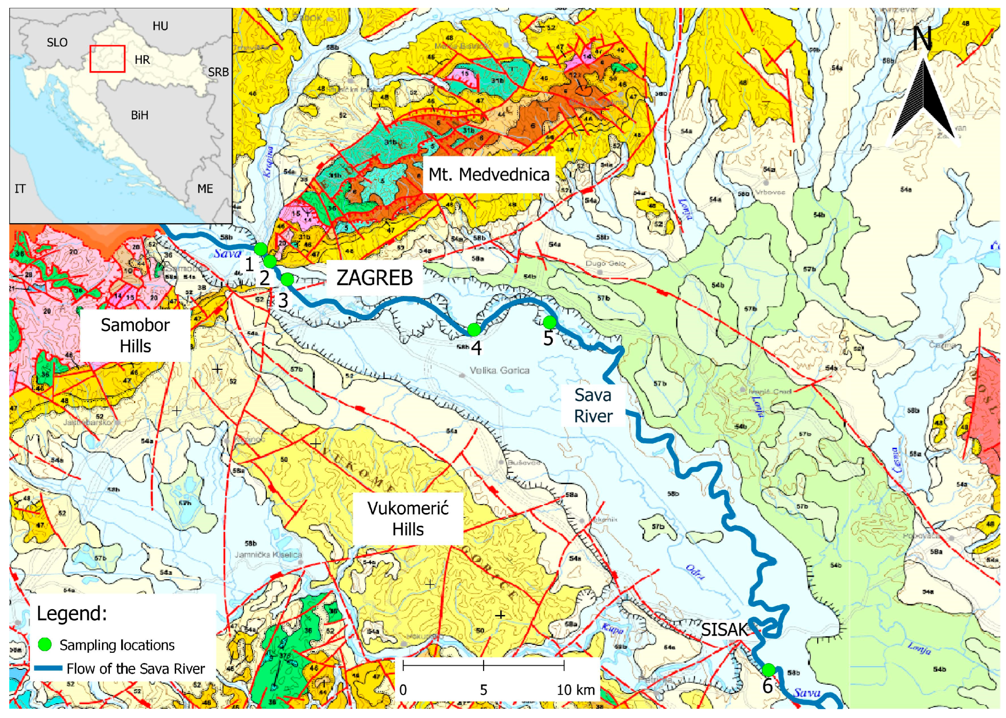
2.2. Field Work and Sampling

Several field and laboratory procedures were used to obtain reliable results of high quality. In the field, representative sites were chosen to sample riverbed sand, from the west towards the east of the city of Zagreb (see Figure 1, sites 1 to 5) along 30 km of traverse, as well as cca 50 km downstream near the city of Sisak, after the right tributary, the Kupa River, enters the Sava River (see Figure 1, site 6). Samples (see Table 1) were taken at the riverbanks (see Figure 2a–f) during low water levels and the low rain period in March and April 2022. Sampling sites in the urban Zagreb City area were chosen mainly under or near the main bridges because sand bodies suitable for sampling were exposed at these sites. Precautions for sampling non-lithified sediment [33] were considered, taking care that a suitable amount of the sample (cca 4 kg) was taken from the single sampling spot, and samples were packed and properly labelled and handled.
Sampling sites are shown in Figure 1. Samples were taken at riverbanks and from the inner (concave) sides of river meanders, reflecting the sedimentation at sandy point bars. In Table 1, the field marks and laboratory numbers of the samples, together with sampling sites’ geographic coordinates in HTRS96/TM, are presented. Chosen sampling sites represent similar riverbed environmental conditions, equally influenced by anthropogenic influence (channelized riverbed and bridge constructions). An exception is the site 6-Sisak, chosen for the comparison of grain size distribution deposited under different riverbed conditions, as well to compare the influence of the first right tributary to that of the provenance of the sand.
The following analytical procedures were performed on the collected samples: granulometric analysis by dry sieving (see Figure 3a), granulometric analysis by laser granulometry (see Figure 3d), magnetic separation (see Figure 3b) and heavy liquid separation [33,34,35,36,37,38,39]. Mineralogic composition in previously separated fractions was determined under a binocular stereoscopic lens (see Figure 3c). Main mineralogy was confirmed by X-ray powder diffraction analyses (XRD) performed on a powdered bulk sample. All analytical procedures were conducted in the Laboratory for Geological Materials (LaGeMa) at the Faculty of Mining, Geology and Petroleum Engineering, University of Zagreb.

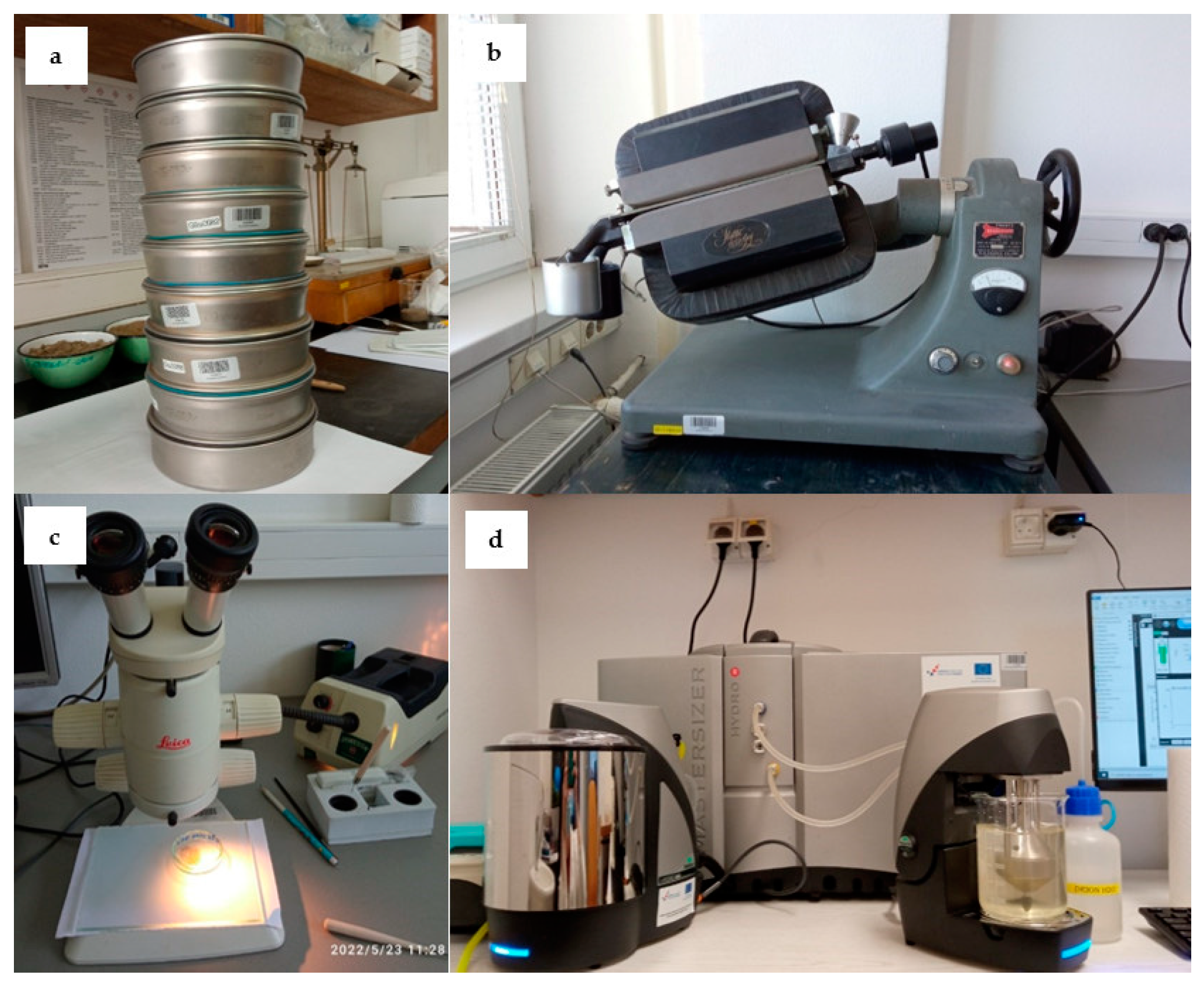
2.3. Grain Size Distribution Determined by Dry Sieving

Samples were dried in the air, reduced by quartering to approximately 100 g, sieved manually through the set of sieves (0.016–0.032–0.064–0.125–0.25–0.5–1.0–2.0 mm) and each fraction was weighed, with an accuracy of >99%. All procedures were performed according to [33].
The results of dry sieving granulometry were presented separately for each sample by histograms of grain size distribution, cumulative frequency of grain size and cumulative granulometric curve.
Standard granulometric parameters were read directly from a cumulative granulometric curve, or calculated from standard equations:
(1) Median (Md)—grain size value on a cumulative granulometric curve at the 50th percentile (at 50%);
(2) Mean (M)—average grain size value, calculated from grain size values at the 16th (Φ16), 50th (Φ50) and 84th (Φ84) percentile (Equation (1)):
M = Φ 16 + Φ 50 + Φ 84 3
where:
Φn—grain size at the nth percentile;
M—mean grain size.
(3) Mode is the value in the middle of the most represented class (class with the largest number of grains);
(4) Sorting (So) is the measure of standard deviation—width of the grain size distribution (Equation (2)). It shows the efficiency of the transporting media (river water) in separating various grain sizes.
S o = Φ 84 Φ 16 4 + Φ 95 Φ 5 6.6
where:
So—sorting coefficient;
Φn—grain size at the nth percentile.
(5) The asymmetry coefficient—Skewness (Sk) shows prevailing fractions in the sample (larger or smaller grains than the median value). It changes the cumulative granulometric curve toward the larger grains (Sk < 1) or toward the smaller grains (Sk > 1). It is calculated from Equation (3).
S k = Φ 16 + Φ 84 2 Φ 50 2 ( Φ 84 Φ 16 ) + Φ 5 + Φ 95 2 Φ 50 2 ( Φ 95 Φ 5 )
where:
Sk—coefficient of asymmetry;
Φn—grain size at the nth percentile.
All procedures were performed according to [33,34].

2.4. Grain Size Distribution Determined by Laser Granulometry

Laser diffraction is an efficient technique for analyzing grain size distribution in medium and fine sediments. It is rapid and non-destructive, applicable for a broad range of grain sizes, as well as highly automated. Laser granulometric analysis was performed with a Malvern Panalytical Mastersizer 3000 device (see Figure 3d), operating on the laser diffraction principle, giving the results in vol. % of the particles determined in the sample. Samples (10 g) were prepared by sieving (<2 mm), cleaning (soaking for 24 h in distilled water) and separating coalesced grains (treatment for 5 min in an ultrasonic bath). Particle shape were considered as predominately “non-spheric” by observation under a binocular magnifier lens and the device was setup accordingly. Finally, the predominant mineral composition was set up as “quartz grains” together with the belonging refractive index, absorption index and density. “Water” was set up as a dispersion medium parameter. Five consecutive measurements were made for each sample (with an error < 5%), and the average value was calculated. The device was cleaned after the measurement of each sample. The results are presented in the cumulative frequency of grain size curves.

2.5. Heavy Liquid Separation

To separate heavy and light mineral fractions from the samples, sodium polytungstate (SPT; s.g. = 2.89 g/cm3) was used. A fraction 0.5–0.25 mm obtained by dry sieving was taken for separation. Approximately 10 g of the sample was mixed in the cuvette with the 7 mL of SPT previously prepared with distilled water to s.g. = 2.7–2.8 g/cm3, centrifuged for 15 min, frozen for 24 h and finally separated in the funnels with the filter paper. All procedures were performed according to [33,34].

2.6. Magnetic Susceptibility Separation

Mineral grains (cca 10 g) in the samples were separated from the fraction 0.5–0.25 mm, based on their magnetic susceptibility, by an isodynamic magnetic separator designed by S. G. Frantz (see Figure 3b). Transverse and longitudinal channels in the separator were set up at 20°, and the current intensity varied from 0.4 A to 0.8 A and 1.2 A to obtain more precisely separated fractions for determination. All procedures were performed according to [33,34].

2.7. Mineralogic–Petrographic Composition

Mineral grains and rock fragments separated by magnetic separation and heavy liquid were observed by a binocular magnifier lens Leica MZ 75 (see Figure 3c) to determine predominant, subordinate and trace minerals and rock fragments, according to their physical characteristics (habitus, color, luster, cleavage). All procedures were performed according to [33].

2.8. X-ray Powder Diffraction Analysis (XRD)

X-ray powder diffraction analyses (XRD) were performed on a powdered bulk sample from all sites, to confirm main mineralogy, previously determined under a binocular stereoscopic lens. Analyses were made on a Panalytical Empyrean diffractometer with a PIXcel3D-Medipix3 1 × 1 line detector, under the following conditions: Cu–Kα radiation (Kα 1.541874 Å), U = 45 Kv, I = 40 mA, recording range 3–70° 2Θ, step 0.0131°, recording speed 0.041683 °/s and divergence of the primary beam 1/2°. The XRD patterns of the bulk sample were recorded after air drying. Recorded diffractograms were interpreted by High Score Plus 4.9 (2020) software, using the PDF-2 mineral database. All procedures were performed according to [33].

3. Results

The results of all the performed analyses (granulometric analysis by sieving and laser granulometry, as well as mineralogic–petrographic determination) are presented in graphics for each sampling site separately, from the west towards the east downstream of the Sava River. Minerals and rock fragments were determined as: (a) predominant; (b) subordinate; and (c) trace minerals/rock fragments. Microphotographs of some characteristic minerals were also taken.
The parameters read off and/or calculated from the cumulative granulometric curve for all samples are listed in Table 2.
The mineralogic–petrographic composition for all samples is shown in Supplementary File S1. The cumulative frequency of grain size distribution obtained by laser granulometry for all samples is presented in Supplementary File S2. Additional XRD analysis on the bulk sample was performed, which confirmed main mineralogy (calcite, dolomite, quartz, feldspar, plagioclase, muscovite). It was not possible to confirm all previously determined minerals, probably due to their small shares in a bulk sample. Interpreted XRD diffractograms are shown in Supplementary File S3.

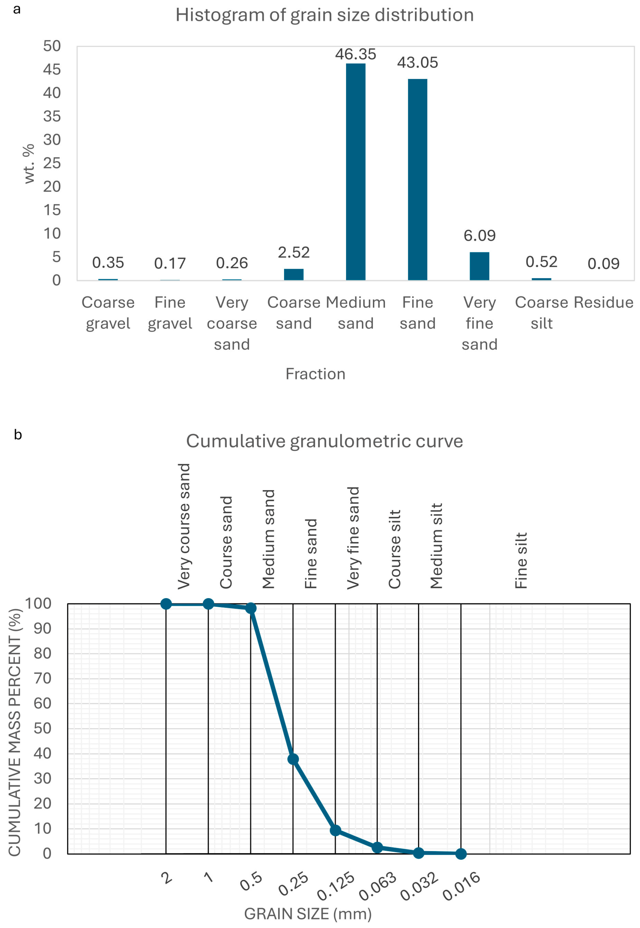
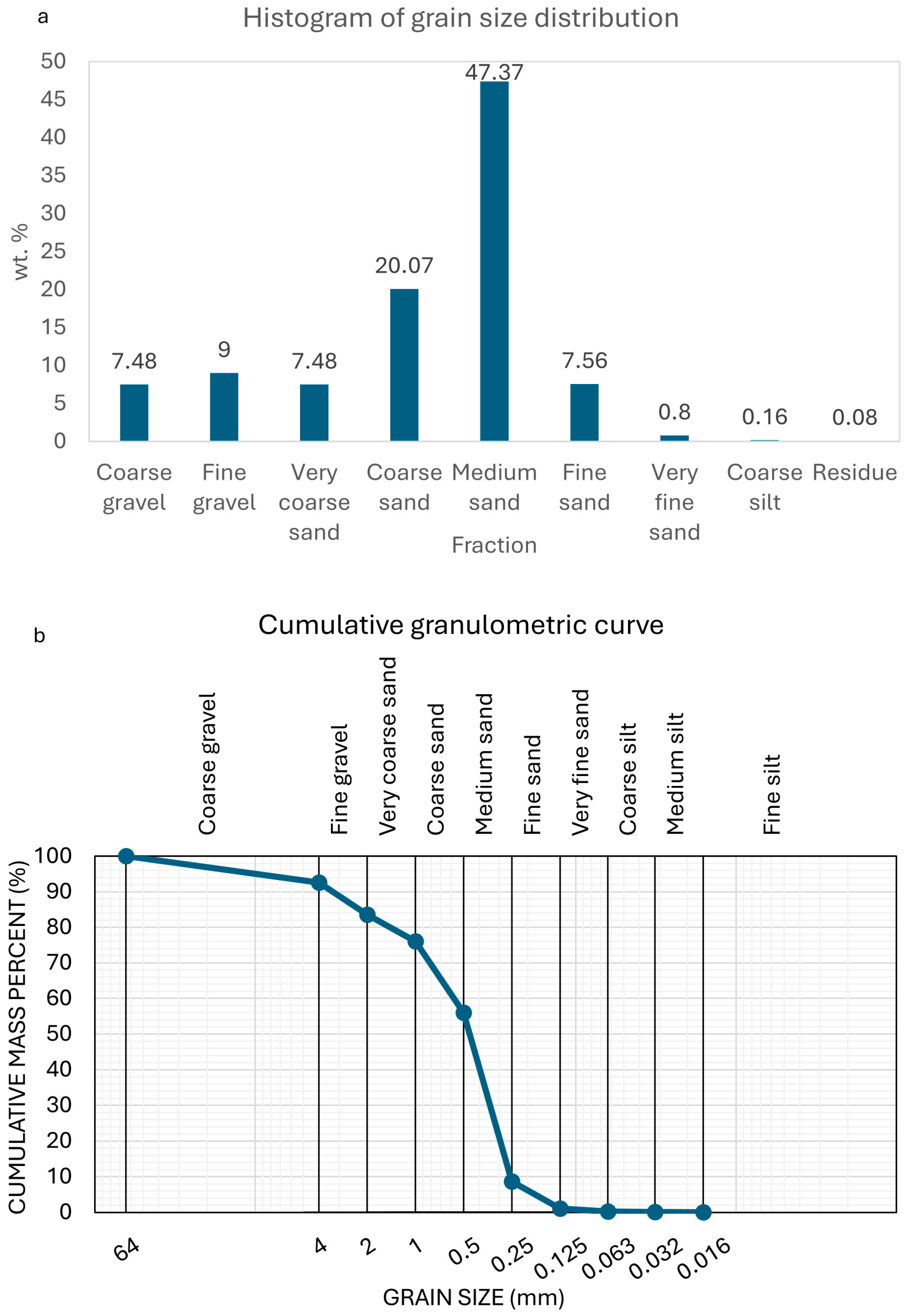
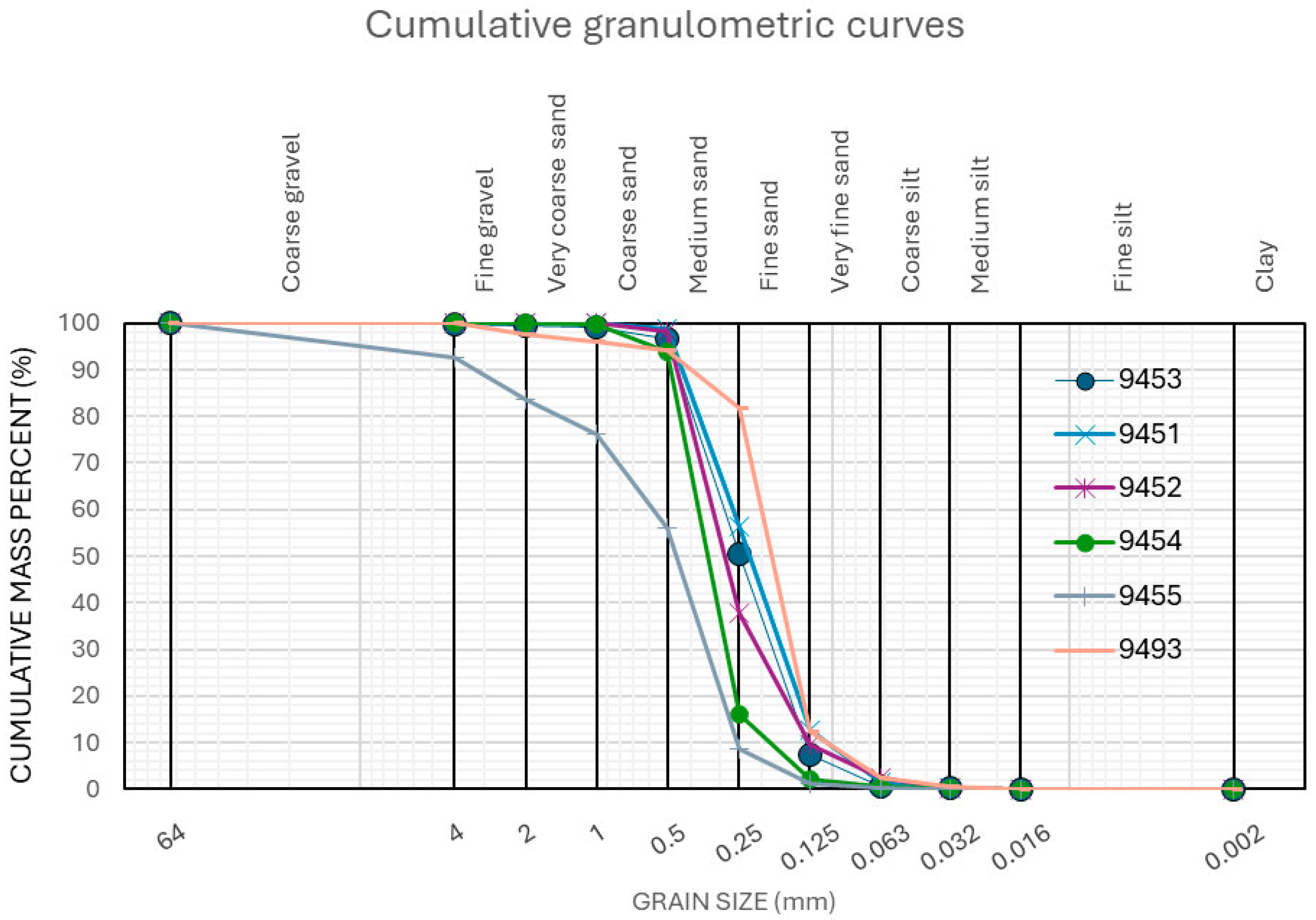
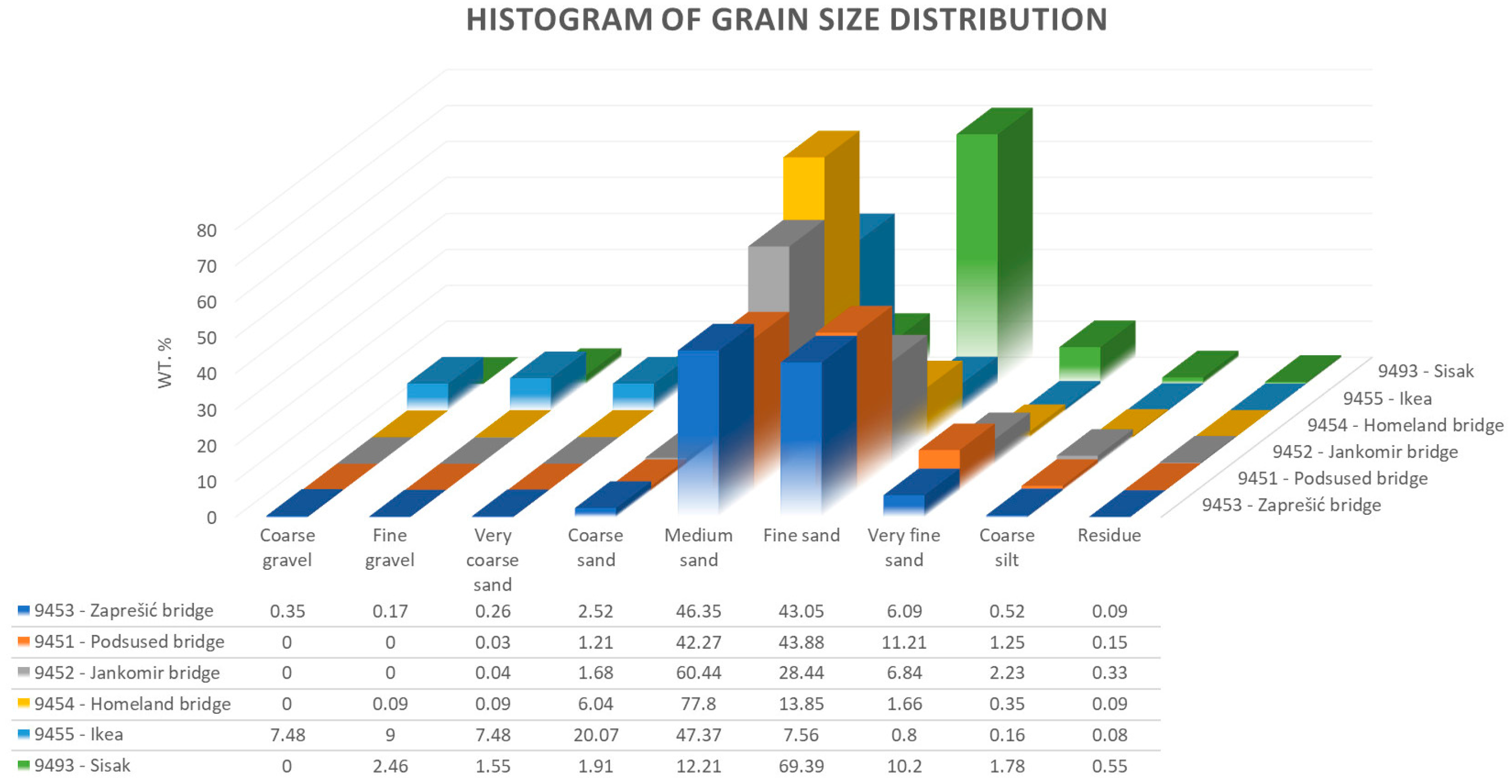
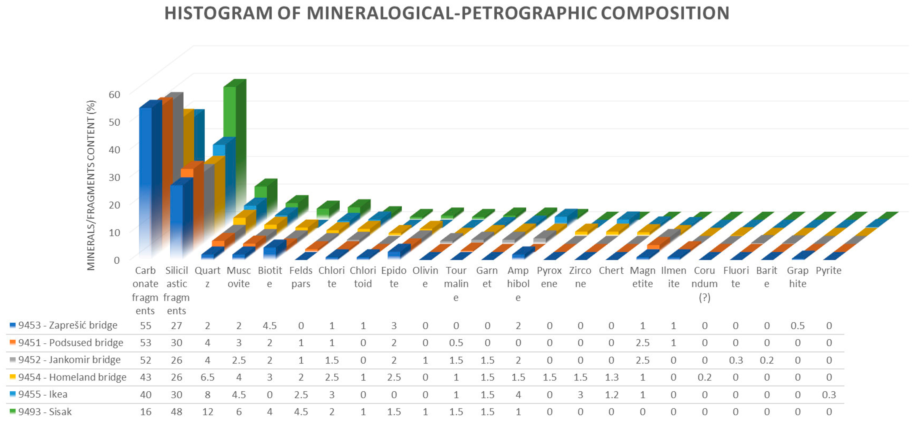
3.1. Sample 9453—Zaprešić Bridge

The weight of the sample separated by quartering from the original sample was 115.6 g, which was taken for sieving. The results are presented on a histogram of grain size distribution (see Figure 4a) and a cumulative granulometric curve (see Figure 4b).
Carbonates (limestone and dolomite fragments) are predominant, while sandstone/silt and magmatic rock fragments are subordinately present. Dolomite is present in heavy mineral fractions and calcite is predominant in light mineral fractions. Both carbonates are also found in nonmagnetic fractions. Biotite, muscovite, quartz, epidote, chloritoid and chlorite are subordinately present. Oxide minerals (magnetite and ilmenite) and graphite are found in traces in magnetic fractions.

3.2. Sample 9451—The Podsused Bridge

The weight of the sample separated by quartering from the original sample was 97.79 g, which was taken for sieving. The results are presented on a histogram of grain size distribution (see Figure 5a), and a cumulative granulometric curve (see Figure 5b).
Carbonates predominate, while sandstone/silt and magmatic rock fragments are subordinated. Among the carbonates, dolomite and siderite are present in heavy mineral fractions, and calcite predominate in light mineral fractions Silicates and oxides are found in traces: micas, epidote, tourmaline, magnetite and ilmenite in magnetic mineral fractions, and quartz in nonmagnetic mineral fractions.

3.3. Sample 9452—The Jankomir Bridge

The weight of the sample separated by quartering from the original sample was 110.39 g, which was taken for sieving. The results are presented on a histogram of grain size distribution (see Figure 6a) and a cumulative granulometric curve (see Figure 6b).
Carbonates still predominate as in the previous samples, while siliciclastic, magmatic and metamorphic rock fragments are subordinately present. Among the carbonates, calcite predominates in light mineral fractions and dolomite in heavy mineral fractions. Epidote, barite and garnet are found in heavy mineral fractions. Magnetite and ilmenite are found in magnetic fractions.

3.4. Sample 9454—The Homeland Bridge

The weight of the sample separated by quartering from the original sample was 114.3 g, which was taken for sieving. The results are presented on a histogram of grain size distribution (see Figure 7a) and a cumulative granulometric curve (see Figure 7b).
Sandstone/silt and effusive rock fragments are increased and carbonates are decreased compared with the previous samples. Quartz and Fe-minerals are mainly covered by a limonitic crust. Chlorite, epidote and garnet are found in heavy mineral fractions, while quartz and muscovite are found in light mineral fractions. Pyroxene and amphibole, as well as epidote, garnet, tourmaline and chlorite are found in magnetic fractions.

3.5. Sample 9455—Ikea

The weight of the sample separated by quartering from the original sample was 125.7 g, which was taken for sieving. The results are presented on a histogram of grain size distribution (see Figure 8a) and a cumulative granulometric curve (see Figure 8b).
Siliciclastic and magmatic rock fragments are further increased, while carbonates, especially dolomite, are decreased. Amphibole, chlorite and zircon are found in heavy mineral fractions, and quartz, feldspar and muscovite in light mineral fractions.

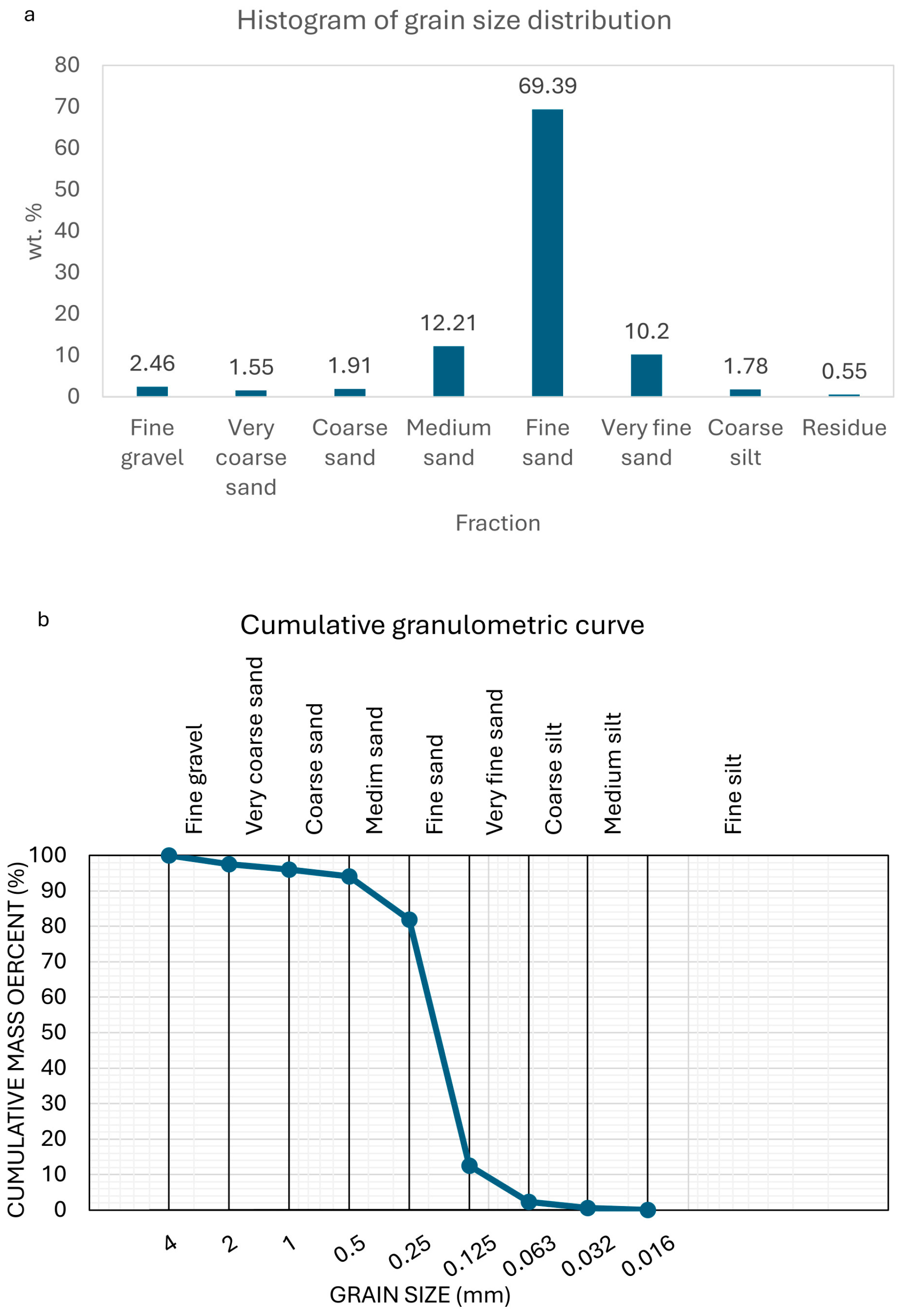
3.6. Sample 9493—Sisak

The weight of the sample separated by quartering from the original sample was 111.0 g, which was taken for sieving. The results are presented on a histogram of grain size distribution (see Figure 9a) and a cumulative granulometric curve (see Figure 9b).
Siliciclastic and magmatic rock fragments are significantly predominant, while carbonates are sharply decreased. Rock fragments and siliciclastic grains are well-rounded and more spheric. Amphibole and garnet are found in heavy mineral fractions. Tourmaline is found in magnetic fractions.
Microphotographs of selected mineral grains from all samples are shown in Figure 10a–i.
Grain size distribution in all the analyzed samples is presented on a jointed graph showing cumulative granulometric curves (see Figure 11). Similar shapes for the 9453, 9451, 9452 and 9454 curves, steepened at fine and medium sand sections of the curves, indicate similar grain size distributions. Apart from that, curve 9455 shows an increase in coarse sand and gravel, while curve 9493 shows an increase of fine sand fractions.
The jointed histogram showing the distribution of granulometric fractions (see Figure 12) more clearly presents the described similarities and differences of grain size distribution—the prevailing medium sand fraction at the 9452, 9454 and 9455 sites, as well as the predominance of fine sand at site 9493.

4. Discussion

4.1. Significance of Grain Size and Provenance Research

Numerous studies of sand deposits in rivers within various geological and geomorphological settings have been designed and conducted all over the world [41,42,43,44,45,46,47,48,49,50,51,52]. They have investigated modern [6] and ancient [41] river systems, from meandering to more channelized rivers as well as their transition [42,43]. Fluvial sandbar deposition [44], morphodynamics and sediment transport at grain scales [45,46], as well as numerous estimating, quantifying or predicting modelling studies and empirical assessments [47,48,49,50,51,52] of river deposits have been investigated and elaborated on.
Comparing to those mentioned, this study is somewhat limited to simple sedimentary research techniques for the grain size distribution and provenance of the Sava River sand in the urban area of the City of Zagreb, as well as its downstream area in the Lonjsko Polje Nature Park. However, several useful conclusions can arise from the discussion of the obtained results.

4.2. Grain Size Distribution and Provenance of Sand Grains in the Study Area

Grain size distribution obtained by dry sieving (see Figure 11 and Figure 12) shows that, upstream of the Sava River at the western sampling sites (9453 and 9451), cumulative medium sand/fine sand fractions are predominant at both sites (89.4 wt.% and 86.15 wt.%, respectively for sites), and very fine sand fraction is subordinately present (6.09 wt.% and 11.21 wt.%, respectively). Cumulative shares of other fractions, fine and coarse, are <2 wt.%. The prevailing hydrodynamic properties of the Sava riverbed in this area allows the deposition of medium and fine sand particles.
Downstream of the Sava River towards the east, at the sampling sites 9452, 9454 and 9455, medium sand fraction increase (60.44 wt.%, 77.8 wt.% and 47.37 wt.%, respectively for sites). Fine sand fractions are subordinated, while coarse sand fractions are almost insignificant at sites 9452 and 9454. Such grain size distribution, with an increase of medium sand deposition downstream, probably reflects a more channelized riverbed due to artificial flood-preventing banks, consequently creating higher hydrodynamic conditions at these sites. On the other hand, a slight increase of coarse sand and gravel fractions is documented at site 9455, probably due to the sampling procedure, where some pebbles were also sampled together with the sand. This is also clearly visible from the calculated sorting coefficient values (0.71 < So > 2 for 9455, comparing with So < 0.35 for 9452 and 9454—Table 2) Apart from this anomaly, for sample 9455, So, M and Sk parameters are similar to those of other samples in Table 2, predominately reflecting the deposition of medium and fine sand.
At the sampling site 9493, some 50 km downstream, fine sand fractions predominate (69.39 wt.%; Figure 12) due to the low hydrodynamic conditions of the Sava River. It flows there through a low-relief area and enters the Lonjsko Polje Nature Park, becoming a non-regulated and more meandering river which deposits fine sand material in sandy point bar alluvial facies [3; 4]. Also, the inflow of the Kupa River immediately upstream from the 9493 site possibly influenced grain size distribution, but this still needs to be investigated.
The results of laser granulometry presented on the cumulative frequency of grain size curves (see Supplementary File S2) showed similar grain size distribution as the results obtained by dry sieving. However, some discrepancies are also observed, due to a more precise detection limit for silt and clay particles by laser granulometry. Two peaks are clearly visible: a large peak at the medium to fine sand fraction (125–500 μm) matching the same peak obtained by the dry sieving method in all samples, and a small peak at the clay fraction (4–16 μm) in samples 9453 and 9454. A smaller peak at the clay fraction probably appeared due to sample treatment before measurement, when the soaking in water and ultrasonic disintegration of the sample resulted in the release of clay coatings around some grains. The laser granulometry method was used in this study to better distinguish silt and clay fractions, and to compare them for all samples. However, apart from the two mentioned minor peaks, other significant differences were not detected.
The provenance part of this research is discussed according to mineral–petrographic determinations from separated mineral fractions. It is also compared with described geological settings upstream from the Sava River, as well as in the surrounding areas (Medvednica Mt. and Samobor Hills), as possible sources of sand grains.
Mineral grains determined in heavy and light mineral fractions, as well as in fractions separated by magnetic susceptibility (see Supplementary File S1 and Figure 10), indicate provenance from several possible sources. The main mineralogy (calcite, dolomite, quartz, feldspar, plagioclase, muscovite), confirmed by XRD analysis, could mainly derive from the upstream sources, but local contributions should also be taken into account. Subordinately represented minerals (chlorite, chloritoid, epidote, olivine, tourmaline, amphibole, pyroxene) could be significantly sourced from the Medvednica Mt., where the assemblage of various magmatic and metamorphic rocks has been extensively investigated [53,54,55,56,57,58,59,60,61,62]. Among rock fragments, carbonate and siliciclastic sedimentary rock fragments prevail, followed by effusive rocks. Again, the provenance of these grains is probably twofold: upstream of the Sava River, as well as contributed to by local sources. On the other hand, the significant absence of ore minerals, well-described in the surroundings of the study area (historical mining sites and drainage areas at the Medvednica Mt. [63,64,65,66], and in the Samobor Hills [67,68,69,70,71]) could indicate somehow limited local transport by streams into the Sava River. However, this is highly speculative and needs confirmation by a broader study.
Several provenance studies [72,73,74] have investigated the Quaternary sand composition of Dolomite Alps provenance deposited in the Po and Modena Plains in northern Italy. Their results and conclusions show the evidence of relatively lower resistance of carbonate grains transported by rivers, compared with siliciclastic, volcanic and metamorphic grains, as well as evidence that the sand composition of some major rivers in the plains has not changed during the Holocene.
Compared with the results obtained for the Sava River, carbonate grain (calcite and dolomite) content decreases downstream of the Sava River, away from its source in the Alpine regions. Moreover, it decreases even at a minor scale, away from the local carbonate grain source areas, the Samobor Hills and SW Medvednica Mt. As for eventual changes of sand composition during the Holocene in Sava River deposits, these cannot be concluded from the obtained results and compared with northern Italy, simply because of the different sampling techniques used (surficial sampling of riverbed sand vs. deep borehole sampling).
Mineralogic–petrographic composition is relatively similar at all sampling sites but with slightly different shares of siliciclastic and carbonate grains downstream of the Sava River (see Figure 13; Supplementary File S1). Carbonates prevail upstream, at the 9453—the Zaprešić Bridge and 9451—the Podsused Bridge sites, followed by sandstone and silt rock clasts, as well as fragments of magmatic and metamorphic rocks, silicate minerals and some oxide minerals. Well-rounded carbonate grains indicate their probably distant upstream sources (from the Alpine regions in Slovenia), but more local sources (the Samobor Hills and SW part of the Medvednica Mt.—see Figure 1) are also highly probable. Various magmatic and metamorphic rock fragments indicate a local source area, mainly from the middle part of the Medvednica Mt. Downstream, at sites 9452—the Jankomir Bridge and 9454—the Homeland Bridge, carbonate grains still prevail but sandstone/silt rock clasts and magmatic/metamorphic rock fragments constantly increase towards the site 9455—Ikea. They significantly prevail over carbonates 50 km downstream at site 9493—Sisak. Considering the position of the 9493 site downstream of the right tributary (the Kupa River inflow in the Sava), the area upstream of the Kupa River (Banovina and Gorski Kotar regions) is highly probable as a significant source of these grains. The Kupa River in its lower part flows through magmatic–siliciclastic (Banovina) terrain [19,20,21,22], and in its upper part through carbonate karst (Gorski Kotar) terrain [23,24]. Carbonate sand originating from karst carbonates is mainly deposited upstream, and siliciclastic sand possibly contributes downstream, at the 9493—Sisak site, in the Sava River.
Determined mineralogic–petrographic composition can be compared with the results of a previous study in the same area [25]. That previous study determined carbonate grains as predominant for sandy deposits of the Sava River in the area near the Slovenia/Croatia border (the Krško Polje in Slovenia, Zaprešić and Rakitje areas in Croatia). This area mainly corresponds with two western sampling sites from our study (sites 9453—the Zaprešić Bridge and 9451—the Podsused Bridge), showing also prevailing carbonate grain content. At sites downstream in study [25], in the abandoned chute (Jarun) and small lakes formed in cut-off meanders of the Sava (Novo Čiče), carbonate content is decreased, as in our study at sites 9452—the Jankomir Bridge and 9454—the Homeland Bridge. Consequently, a predominant source of non-carbonate sand grains is probably the Medvednica Mt., which is in its middle part mainly composed of metamorphic (i.e., greenschists, as the most prominent), as well as magmatic and siliciclastic sedimentary rocks. Several streams flowing from the Medvednica into the Sava River contributed to the increase of non-carbonate grain content in the Sava riverbed sand. Further downstream (near Dugo Selo, corresponding to our 9455—Ikea site), non-carbonate components prevail over carbonates, as in our study.
In the previous study [25], sand from the Sava riverbed and associated with the Holocene alluvial sand lithofacies in the Zagreb Alluvial Plain have been also compared with the riverbed sand 250 km downstream of the Sava River, near Slavonski Šamac. A significant absence of carbonates (especially dolomite) has been found there, together with variable contents of minerals and fragments of metamorphic, magmatic and siliciclastic rocks. Several tributaries downstream of the Sava River, between Zagreb and Slavonski Šamac (rivers: Kupa, Una, Orljava, Vrbas and Bosna), significantly contributed to the determined content. Our study detected a significant decrease in carbonates and an increase in other components just 50 km downstream (at site 94943—Sisak), after the inflow of the first major tributary, the Kupa River. The reason for that result could be the intensive weathering and limited transport of fragile carbonate sand grains downstream, due to their low hardness.
In a more recent study [32], the morphometric and petrographic characteristics of gravel pebbles from the Sava River near Zagreb were described, approximately in the same area as in our study. Limestone pebbles were found as predominant along the Sava watercourse near Zagreb and its surroundings. Their shapes were determined as spherical to discoidal, pointing to several source areas, distant and local. Other determined lithotypes in gravel pebbles of the Sava River were, as follows: dolomites, effusive rocks, conglomerates, sandstones, cherts/quartz, tuffs, marls and shales. As the main sources of carbonate pebbles, the distant Alpine Provinces in Slovenia as well as the local area (the Samobor Hills and SW part of the Medvednica Mt.) were indicated [75,76,77,78]. The same sources could also be associated with the carbonate sand grains in our study, especially with an increased content of carbonates at the western sites (sites 9453—the Zaprešić Bridge and 9451—the Podsused Bridge). Generally, the determined prevailing carbonate sands in the western and more siliciclastic content downstream in the eastern part of the investigated area showed a similar pattern as the distribution of gravel pebbles in study [32], which was somehow expected and now confirmed.

4.3. Shortcomings and Prospects of This Study

Some considerations regarding this study should also be accentuated. The study area was relatively confined, focusing on the part of the Sava River watercourse mainly in the urban city area, with significantly regulated riverbeds influencing natural grain size distribution. This study focuses on sand, a middle-coarse sediment deposited in the riverbed at a moderate water energy, which prevails in the observed area. Planned exclusion of the coarse (gravel) and fine (silt and mud) fractions inevitably influenced the sampling strategy. Available sites with similar depositional conditions were selected, but with one site (9455—Ikea) slightly different (including some gravel pebbles), which also creates difficulties when comparing results. The reported provenance of the sand grains should be considered as a trend and guideline for further studies, which can include sampling in the tributaries.
The results of this study of grain distribution and provenance of the Sava River sand could be interesting for research and comparison of the Zagreb alluvial aquifer system deposits, as well as for urban planning and environmental protection studies along the observed traverse. A study of grain size distribution and provenance can be also extended along the waterway of the Sava River and the tributaries as a regional study, but the sampling strategy should be re-designed according to the study area.

5. Conclusions

Several conclusions can be drawn from this study:
-
Upstream, in the western part of the City of Zagreb, predominately carbonate sand of distant (Alpine) and local (Medvednica Mt. and Samobor Hills) provenance prevail. Downstream, in the middle and eastern part of the City of Zagreb area, more siliciclastic sand is deposited in the Sava riverbed, originating mainly from the Medvednica Mt.;
-
More prevailing siliciclastic sand further downstream of the Sava River, near the city of Sisak, can be considered as a contribution from the Kupa River tributary;
-
Moreover, grain size distribution of the Sava River sands near the city of Zagreb show predominately medium and fine sand deposition, with prevailing medium sand downstream, due to a more artificially channelized riverbed;
-
Further 50 km downstream, near the city of Sisak and entering the Lonjsko Polje Nature Park, fine sand deposition significantly prevails, influenced by the lower hydrodynamic conditions and possible fine sand contribution of the Kupa River tributary;
-
Although various studies of the Zagreb alluvial aquifer system have been conducted so far, this study represent a novelty in its investigation into the grain size distribution of the riverbed sand itself, setting the foundations for investigations in the future;
-
Possible shortcomings of this study include the sampling strategy and the provenance aspects, which can be improved in future studies by broadening the scope of the study to near tributaries, as well as on the streams entering the Sava River. Since these streams mainly flow from the Medvednica Mt. through the urban city area, anthropogenic influence should be also considered.

Supplementary Materials

The following supporting information can be downloaded at: https://www.mdpi.com/article/10.3390/geosciences14070188/s1, File S1: Summary of mineralogic–petrographic composition for all samples; File S2: Cumulative frequency of grain size distribution was obtained by laser granulometry for all samples; File S3: Interpreted diffractograms from XRD analysis for bulk samples.

Author Contributions

Conceptualization, U.B., M.B. and T.M.; methodology U.B. and M.B.; validation, U.B and T.M; investigation, U.B. and M.B.; writing—original draft preparation, U.B.; writing—review and editing, U.B., M.B. and T.M.; visualization, M.B. All authors have read and agreed to the published version of the manuscript.

Funding

This research received no external funding.

Data Availability Statement

No new data were created or analyzed in this study. Data sharing is not applicable to this article.

Acknowledgments

The authors thank the anonymous reviewers and editors for their generous and constructive comments that have improved this paper. This research was partially carried out in the projects “Mathematical researching in geology VIII&IX” (led by T. Malvić).

Conflicts of Interest

The authors declare no conflicts of interest.

References

  1. Collinson, J.D. Alluvial Sediments. In Sedimentary Environments and Facies, 2nd ed.; Reading, H.G., Ed.; Blackwell Scientific Publications: Oxford, UK, 1986; pp. 20–62. [Google Scholar]
  2. Stow, D.A.V. Sedimentary Rocks in the Field—A Colour Guide; Manson Publishing: London, UK, 2005; 320p. [Google Scholar]
  3. Reading, H.G. Sedimentary Environments and Facies, 2nd ed.; Blackwell Scientific Publications: Oxford, UK, 1986; 615p. [Google Scholar]
  4. Miall, A.D. The Geology of Fluvial Deposits: Sedimentary Petroleum Geology; Springer: Berlin/Heidelberg, Germany, 1996; 582p. [Google Scholar]
  5. Boggs, S., Jr. Principles of Sedimentology and Stratigraphy; Prentice Hall: New York, NY, USA, 2011; 600p. [Google Scholar]
  6. Etobro, I.A.A.; Ejeh, O.I.; Ovwamuedo, G.O. Fluvial sedimentology of the river Ethiope sediments, Niger Delta, Southern Nigeria. Rud.-Geološko-Naft. Zb. 2024, 39, 45–61. [Google Scholar] [CrossRef]
  7. Dill, H.G.; Klosa, D. Heavy-mineral-based provenance analysis of Mesozoic continental-marine sediments at the western edge of the Bohemian Massif, SE Germany: With special reference to Fe-Ti minerals and the crystal morphology of heavy minerals. Int. J. Earth Sci. 2011, 100, 1497–1513. [Google Scholar] [CrossRef]
  8. Kovačić, M.; Grizelj, A. Provenance of the Upper Miocene clastic material in the southwestern part of the Pannonian Basin. Geol. Carpathica 2006, 57, 495–510. [Google Scholar]
  9. Grizelj, A.; Peh, Z.; Tibljaš, D.; Kovačić, M.; Kurečić, T. Mineralogical and geochemical characteristics of Miocene pelitic sedimentary rocks from the south-western part of the Pannonian Basin System (Croatia): Implications for provenance studies. Geosci. Front. 2017, 811, 65–80. [Google Scholar] [CrossRef]
  10. Nakić, Z.; Ružičić, S.; Posavec, K.; Mileusnić, M.; Parlov, J.; Bačani, A.; Durn, G. Conceptual model for groundwater status and risk assessment–case study of the Zagreb aquifer system. Geol. Croat. 2013, 66, 55–77. [Google Scholar] [CrossRef]
  11. Vujević, M.; Posavec, K. Identification of groundwater level decline in Zagreb and Samobor-Zaprešić aquifers since the sixties of the twentieth century. Rud.-Geološko-Naft. Zb. 2018, 33, 55–64. Available online: https://hrcak.srce.hr/ojs/index.php/rgn/article/view/6776 (accessed on 25 April 2024). [CrossRef]
  12. Kapuralić, J.; Posavec, K.; Kurevija, T.; Macenić, M. Identification of River Sava temperature influence on groundwater temperature of the Zagreb and Samobor-Zaprešić aquifer as a part of shallow geothermal potential. Rud.-Geološko-Naft. Zb. 2018, 33, 59–69. Available online: https://hrcak.srce.hr/ojs/index.php/rgn/article/view/7575 (accessed on 25 April 2024). [CrossRef]
  13. Brkić, Ž. The relationship of the geological framework to the Quaternary aquifer system in the Sava River valley (Croatia). Geol. Croat. 2017, 70, 201–213. [Google Scholar] [CrossRef]
  14. Kovač, Z.; Nakić, Z.; Pavlić, K. Influence of groundwater quality indicators on nitrate concentrations in the Zagreb aquifer system. Geol. Croat. 2017, 70, 93–103. [Google Scholar] [CrossRef]
  15. Trenc, N.; Matoš, B.; Velić, J.; Perković, D. Application of GIS Procedure for River Terrace extraction from LiDAR- based DEM: Sava River Valley NW of Zagreb, Croatia. Rud.-Geološko-Naft. Zb. 2018, 34, 59–70. Available online: https://hrcak.srce.hr/ojs/index.php/rgn/article/view/7279 (accessed on 25 April 2024). [CrossRef]
  16. Ružičić, S.; Kovač, Z.; Tumara, D. Physical and chemical properties in relation with soil permeability in the area of Velika Gorica well field. Rud.-Geološko-Naft. Zb. 2018, 33, 73–82. [Google Scholar] [CrossRef]
  17. Šikić, K.; Basch, O.; Šimunić, A. Basic Geological Map of SFR Yugoslavia, 1:100,000, Geology of the Zagreb Sheet; Geological Institute Zagreb, Federal Geological Institute: Belgrade, Serbia, 1979; p. 81. (In Croatian) [Google Scholar]
  18. Basch, O. Basic Geological Map of SFR Yugoslavia, 1:100,000, Geology of the Ivanić-Grad Sheet; Geological Institute Zagreb, Federal Geological Institute: Belgrade, Serbia, 1983; p. 66. (In Croatian) [Google Scholar]
  19. Šikić, K.; Basch, O.; Šimunić, A. Basic Geological Map of SFR Yugoslavia, 1:100,000, Zagreb Sheet, L33; Geological Institute Zagreb, Federal Geological Institute: Belgrade, Serbia, 1977. (In Croatian) [Google Scholar]
  20. Basch, O. Basic Geological Map of SFR Yugoslavia, 1:100,000, Ivanić-Grad Sheet, L33-81; Geological Institute Zagreb, Federal Geological Institute: Belgrade, Serbia, 1983. (In Croatian) [Google Scholar]
  21. Pikija, M. Basic Geological Map of SFR Yugoslavia, 1:100,000, Geology of the Sisak Sheet; Geological Institute Zagreb, Federal Geological Institute: Belgrade, Serbia, 1987; p. 55. (In Croatian) [Google Scholar]
  22. Pikija, M. Basic Geological Map of SFR Yugoslavia, 1:100,000, Zagreb Sheet, L33-93; Geological Institute Zagreb, Federal Geological Institute: Belgrade, Serbia, 1987. (In Croatian) [Google Scholar]
  23. Geological Map of the Republic of Croatia at a Scale 1:300.000. Croatian Geological Survey, Zagreb. 2009. (In Croatian). Available online: http://webgis.hgi-cgs.hr/gk300/default.aspx (accessed on 25 April 2024.).
  24. Velić, I.; Vlahović, I. (Eds.) Guide to the Geological Map of the Republic of Croatia at a scale 1:300,000; Croatian Geological Survey: Zagreb, Croatia, 2009; p. 141. (In Croatian) [Google Scholar]
  25. Crnković, B.; Bušić, M. Mineralogical and petrological composition of the Sava River sediment. In Proceedings of the 30th Anniversary of the RGN Faculty (1939–1969), Zagreb, Croatia, 4 December 1970; pp. 133–140. (In Croatian). [Google Scholar]
  26. Šimunić, A.; Basch, O. The stratigraphy of Quaternary sediments in the Zagrebačko Posavlje. Geološki Vjesn. 1975, 28, 153–164. (In Croatian) [Google Scholar]
  27. Babić, Ž.; Čakarun, I.; Sokač, A.; Mraz, V.O. About the geology of Quaternary deposits of the Drava River basin. Geološki Vjesn. 1978, 30, 43–61. (In Croatian) [Google Scholar]
  28. Šimunić, A.; Novosel-Škorić, S.; Piljurović, L. Lithological correlation and chronostratigraphic delimitation of Quaternary sediments at the location Prevlaka southeast of Zagreb. Geološki Vjesn. 1988, 41, 167–179. (In Croatian) [Google Scholar]
  29. Velić, J.; Saftić, B. Subsurface Spreading and Facies Characteristics of Middle Pleistocene Deposits between Zaprešić and Samobor. Geološki Vjesn. 1991, 44, 69–82. [Google Scholar]
  30. Velić, J.; Durn, G. Alternating Lacustrine-Marsh Sedimentation and Subaerial Exposure Phases during Quaternary: Prečko, Zagreb, Croatia. Geol. Croat. 1993, 46, 71–90. [Google Scholar]
  31. Velić, J.; Saftić, B.; Malvić, T. Lithological Composition and Stratigraphy of Quaternary Sediments in the Area of the „Jakuševec“ Waste Depository (Zagreb, Northern Croatia). Geol. Croat. 1999, 52, 119–130. [Google Scholar] [CrossRef]
  32. Barudžija, U.; Velić, J.; Malvić, T.; Trenc, N.; Matovinović, N. Morphometric Characteristics, Shapes and Provenance of Holocene Pebbles from the Sava River Gravels (Zagreb, Croatia). Geosciences 2020, 10, 92. [Google Scholar] [CrossRef]
  33. Tucker, M.E. Techniques in Sedimentology; Blackwell Scientific Publications: Oxford, UK, 1988; 394p. [Google Scholar]
  34. Müller, G. Methods in Sedimentary Petrology. Sedimentary Petrology—Part 1; Schweizerbart: Stuttgart, Germany, 1967; p. 283. [Google Scholar]
  35. Edwards, A.C. Grain size and sorting in modern beach sands. J. Coast. Res. 2001, 17, 38–52. [Google Scholar]
  36. Wentworth, C.K. A scale of grade and class terms for clastic sediments. J. Geol. 1922, 30, 377–392. [Google Scholar] [CrossRef]
  37. Inman, D.L. Measures for describing the size distribution of sediments. J. Sediment. Petrol. 1952, 22, 125–145. [Google Scholar]
  38. McCommon, R.B. Efficiencies of percentile measures for describing the mean size and sorting of sedimentary particles. J. Geol. 1962, 70, 453–465. [Google Scholar] [CrossRef]
  39. Folk, R.L.; Ward, W.C. Brazos River bar: A study in the significance of grain size parameters. J. Sediment. Petrol. 1958, 27, 3–26. [Google Scholar] [CrossRef]
  40. Warr, L.N. IMA–CNMNC approved mineral symbols. Mineral. Mag. 2021, 85, 291–320. [Google Scholar] [CrossRef]
  41. Baiyegunhi, C.; Liu, K.; Gwavava, O. Grain size statistics and depositional pattern of the Ecca Group sandstones, Karoo Supergroup in the Eastern Cape Province, South Africa. Open Geosci. 2017, 9, 554–576. [Google Scholar] [CrossRef]
  42. Dill, H.G.; Buzatu, A.; Balaban, S.-I.; Ufer, K.; Techmer, A.; Schedlinsky, W.; Füssl, M. The transition of very coarse-grained meandering to straight fluvial drainage systems in a tectonized foreland-basement landscape during the Holocene (SE Germany)—A joint geomorphological-geological study. Geomorphology 2020, 370, 107364. [Google Scholar] [CrossRef]
  43. Dill, H.G.; Buzatu, A.; Balaban, S.-I. Straight to low-low sinuosity drainage systems in a Variscan-Type Orogen-Constraints from tectonics, lithology and climate. Minerals 2021, 11, 933. [Google Scholar] [CrossRef]
  44. Alexander, J.S.; McElroy, B.J.; Huzurbazar, S.; Murr, M.L. Elevation gaps in fluvial sandbar deposition and their implications for paleodepth estimation. Geology 2020, 48, 718–722. [Google Scholar] [CrossRef]
  45. Ganti, V.; Lamb, M.; McElroy, B. Quantitative bounds on morphodynamics and implications for reading the sedimentary record. Nat. Commun. 2014, 5, 3298. [Google Scholar] [CrossRef]
  46. Naqshband, S.; McElroy, B. Sediment transport at grain scale: A review, future research and morphological implications. In River Flow; Constantinescu, G., Hanes, D., Eds.; Taylor & Francis: London, UK, 2016; pp. 914–919. ISBN 978-1-138-02913-2. [Google Scholar]
  47. Straub, K.M.; Mohrig, D.; Buttles, J.; McElroy, B.; Pirmez, C. Quantifying the influence of channel sinuosity on the depositional mechanics of channelized turbidity currents: A laboratory study. Mar. Pet. Geol. 2011, 28, 744–760. [Google Scholar] [CrossRef]
  48. Ashley, T.C.; McElroy, B.; Buscombe, D.; Grams, P.E.; Kaplinski, M. Estimating bedload from suspended load and water discharge in sand bed rivers. Water Resour. Res. 2020, 56, e2019WR025883. [Google Scholar] [CrossRef]
  49. Dong, T.Y.; Nittrouer, J.A.; Czapiga, M.J.; Ma, H.; McElroy, B.; Il’icheva, E.; Pavlov, M.; Chalov, S.; Parker, G. Roles of bank material in setting bankfull hydraulic geometry as informed by the Selenga River Delta, Russia. Water Resour. Res. 2019, 55, 827–846. [Google Scholar] [CrossRef]
  50. Dong, T.Y.; Nittrouer, J.A.; McElroy, B.; Il’icheva, E.; Pavlov, M.; Ma, H.; Moodie, A.J.; Moreido, V.M. Predicting water and sediment partitioning in a delta channel network under varying discharge conditions. Water Resour. Res. 2020, 56, e2020WR027199. [Google Scholar] [CrossRef]
  51. Naqshband, S.; McElroy, B.; Mahon, R.C. Validating a universal model of particle transport lengths with laboratory measurements of suspended grain motions. Water Resour. Res. 2017, 53, 4106–4123. [Google Scholar] [CrossRef]
  52. Trampush, S.M.; Huzurbazar, S.; McElroy, B. Empirical assessment of theory for bankfull characteristics of alluvial channels. Water Resour. Res. 2014, 50, 9211–9220. [Google Scholar] [CrossRef]
  53. Vrkljan, M.; Garašić, V. Different geochemical signatures developed in some basic magmatic rocks of Mt. Kalnik (North Croatia). Rud.-Geološko-Naft. Zb. 2004, 16, 65–73. [Google Scholar]
  54. Lugović, B.; Šegvić, B.; Altherr, R. Petrology, geochemistry and tectonic significance of the orthogreenschists from the SW Zagorje-Mid-Transdanubian Zone (Medvednica Mts, Croatia). Ofioliti 2006, 39, 31–50. [Google Scholar]
  55. Lugović, B.; Slovenec, D.A.; Halamić, J.; Altherr, R. Petrology, geochemistry and geotectonic affinity of the Mesozoic ultramafic rocks from the southwesternmost Mid-Transdanubian Zone in Croatia. Geol. Carpathica 2007, 58, 511–530. [Google Scholar]
  56. Slovenec, D.A.; Lugović, B. Amphibole gabbroic rocks from the Mt. Medvednica ophiolite mélange (NW Croatia): Geochemistry and tectonic setting. Geol. Carpathica 2008, 59, 277–293. [Google Scholar]
  57. Slovenec, D.; Lugović, B. Geochemistry and tectono-magmatic affinity of mafic extrusive and dyke rocks from the ophiolite melange in the SW Zagorje-Mid-Transdanubian Zone (Mt. Medvednica, Croatia). Ofioliti 2009, 34, 63–80. [Google Scholar]
  58. Slovenec, D.A.; Lugović, B.; Meyer, H.-P.; Garapić-Šiftar, G. A tectono-magmatic correlation of basaltic rocks from ophiolite mélanges at the north-eastern tip of the Sava-Vardar suture Zone, Northern Croatia, constrained by geochemistry and petrology. Ofioliti 2011, 36, 77–100. [Google Scholar]
  59. Slovenec, D.; Lugović, B. Evidence of the spreading culmination in the Eastern Tethyan Repno oceanic domain assessed by the petrology and geochemistry of N-MORB extrusive rocks from the Mt. Medvednica ophiolite mélange (NW Croatia). Geol. Croat. 2012, 65, 435–446. [Google Scholar] [CrossRef]
  60. Lugović, B.; Slovenec, D.; Schuster, R.; Schwarz, W.H.; Horvat, M. Petrology, geochemistry and tectono-magmatic affinity of gabbroic olistoliths from the ophiolite mélange in the NW Dinaric-Vardar ophiolite zone (Mts. Kalnik and Ivanščica, North Croatia). Geol. Croat. 2015, 68, 25–49. [Google Scholar] [CrossRef]
  61. Šegvić, B.; Lugović, B.; Slovenec, D.A.; MeyerR, H.-P. Mineralogy, petrology and geochemistry of amphibolites from the Kalnik Mt. (Sava Unit, North Croatia): Implications for the evolution of north-westernmost part of the Dinaric- Vardar branch of Mesozoic Tethys. Ofioliti 2016, 41, 35–58. [Google Scholar] [CrossRef]
  62. Slovenec, D.; Šegvić, B. The first record of ultramafic cumulates from the Mt. Kalnik ophiolite mélange in the SW part of the Zagorje-Mid-Transdanubian Zone (NW Croatia): Mineralogy, petrology, geochemistry and tectono-magmatic affinity. Geol. Croat. 2018, 71, 185–197. [Google Scholar] [CrossRef]
  63. Šinkovec, B.; Palinkaš, L.; Durn, G. Ore occurrences on Mt. Medvednica. Geološki Vjesn. 1988, 41, 395–405, (In Croatian, with English Summary). [Google Scholar]
  64. Durn, G.; Miko, S.; Čović, M.; Barudžija, U.; Tadej, N.; Namjesnik-Dejanović, K.; Palinkaš, L. Distribution and behaviour of selected elements in soil developed over a historical Pb–Ag mining site at Sv. Jakob, Croatia. J. Geochem. Explor. 1999, 67, 361–376. [Google Scholar] [CrossRef]
  65. Halamić, J.; Peh, Z.; Bukovec, D.; Miko, S.; Galović, L. A factor model of the relationship between stream sediment geochemistry and adjacent drainage basin lithology, Medvednica Mt., Croatia. Geol. Croat. 2001, 54, 37–51. [Google Scholar] [CrossRef]
  66. Galović, L.; Peh, Z.; Halamić, J.; Bukovec, D. Geochemical atlas of the Medvednica Mt.: Natural distribution of geochemical elements in stream sediments. J. Maps 2012, 8, 478–483. [Google Scholar] [CrossRef]
  67. Šinkovec, B. Geologija ležišta željezne i bakrene rude u Rudama kraj Samobora. Geološki Vjesn. 1971, 24, 165–181. (In Croatian) [Google Scholar]
  68. Palinkaš, L.; Borojević Šoštarić, S.; Strmić Palinkaš, S.; Prochaska, W.; Spangenberg, J.; Cuna, S.; Šinkovec, B. Permian–polysulphide-siderite–barite–haematite deposit Rude in Samoborska Gora Mts., Zagorje–Mid–Transdanubian zone of the Internal Dinarides. Geol. Croat. 2010, 63, 93–115. [Google Scholar] [CrossRef]
  69. Strmić Palinkaš, S.; Palinkaš, L.A.; Kuzmanović, M.; Martinić, M.; Kampić, Š.; Dogančić, D.; Obhođaš, J. Environmental geochemistry of the polymetallic ore deposits: Case studies from the Rude and the Sv. Jakob historical mining sites, NW Croatia. Geol. Croat. 2013, 66, 129–142. [Google Scholar] [CrossRef]
  70. Bilić, Š.; Garašić, V. Petrological characteristics of clastic sedimentary rocks from the St. Barbara ore mine in Rude near Samobor. Rud.-Geološko-Naft. Zb. 2021, 36, 1. [Google Scholar] [CrossRef]
  71. Grizelj, A.; Bakrač, K.; Horvat, M.; Avanić, R.; Hećimović, I. Occurrence of vivianite in alluvial Quaternary sediments in the area of Sesvete (Zagreb, Croatia). Geol. Croat. 2017, 70, 41–52. [Google Scholar] [CrossRef]
  72. Picard, M.D.; McBride, E.F. Comparison of river and beach sand composition with source rocks, Dolomite Alps drainage basins, northeastern Italy. In Sedimentary Provenance and Petrogenesis: Perspectives from Petrography and Geochemistry; Arribas, J., Critelli, S., Johnsson, M.J., Eds.; GSA Special Paper 420; Geological Society of America: Boulder, CO, USA, 2007; Volume 381, pp. 1–12. [Google Scholar]
  73. Amorosi, A.; Colalongo, M.L.; Dinelli, E.; Lucchini, F.; Vaiani, S.C. Cyclic variations in sediment provenance from late Pleistocene deposits of the eastern Po Plain, Italy. In Sedimentary Provenance and Petrogenesis: Perspectives from Petrography and Geochemistry; Arribas, J., Critelli, S., Johnsson, M.J., Eds.; GSA Special Paper 420; Geological Society of America: Boulder, CO, USA, 2007; Volume 381, pp. 13–24. [Google Scholar]
  74. Lugli, S.; Marchetti Dori, S.; Fontana, D. Alluvial sand composition as a tool to unravel late Quaternary sedimentation of the Modena Plain, northern Italy. In Sedimentary Provenance and Petrogenesis: Perspectives from Petrography and Geochemistry; Arribas, J., Critelli, S., Johnsson, M.J., Eds.; GSA Special Paper 420; Geological Society of America: Boulder, CO, USA, 2007; Volume 381, pp. 57–72. [Google Scholar]
  75. Šikić, K. Overview of geological structure of the Medvednica Mt. In Geological Guide through Medvednica Mt.; Šikić, K., Ed.; Zagreb, Croatia, 1995; pp. 7–40. (In Croatian) [Google Scholar]
  76. Pavičić, I.; Dragičević, I.; Vlahović, T.; Grgasović, T. Fractal analysis of fracture systems in Upper Triassic Dolomites in Žumberak Mountain, Croatia. Rud.-Geološko-Naft. Zb. 2017, 32, 1–13. [Google Scholar] [CrossRef]
  77. Maričić, A.; Starčević, K.; Barudžija, U. Physical and mechanical properties of dolomites related to sedimentary and diagenetic features–case study of the Upper Triassic dolomites from Medvednica and Samobor Mts., NW Croatia. Rud.-Geološko-Naft. Zb. 2018, 33, 33–44. Available online: https://hrcak.srce.hr/ojs/index.php/rgn/article/view/6147 (accessed on 25 April 2024). [CrossRef]
  78. Sremac, J.; Velić, J.; Bošnjak, M.; Velić, I.; Kudrnovski, D.; Troskot-Čorbić, T. Depositional Model, Pebble Provenance and Possible Reservoir Potential of Cretaceous Conglomerates: Example from the Southern Slope of Medvednica Mt. (Northern Croatia). Geosciences 2018, 8, 456. [Google Scholar] [CrossRef]
Figure 1. Geology of the study area. Red box within inlet (upper left) represents research area shown in geological map. Recent flow of the Sava River is marked with the blue curve. Sampling sites (green dots 1–6): 1—Zaprešić Bridge; 2—Podsused Bridge; 3—Jankomir Bridge; 4—Homeland Bridge; 5—Ikea; 6—Sisak; modified after [23]. Legend for geology after [24]: 5—ortho-metamorphic rocks (Paleozoic to Triassic; Pz, ?T), 6—para-metamorphic rocks (Paleozoic to ?Triassic; Pz, ?T), 10—permanently clastic deposits (Carbonian, Permian; C, P), 12—magmatics: quartz diorites, granodiorites (? Permian; χ P), 14—siliciclastics–carbonates (Lower Triassic; T1), 15—carbonates (Middle Triassic; T2), 20—dolomites (Norian to Rhaetian; T32,1), 21—limestones and dolomites (Lower Jurassic; J1), 31b—ophiolitic magmatic rocks (Middle to Upper Jurassic; J2,3), 36—carbonate clastics and “Scaglia“ limestones (Upper Cretaceous; K2), 37β—basalts (Upper Cretaceous, Paleogene; K2, Pg), 44—clastics and carbonates with clastics (Ottnangian to Carpathian; M2,3), 46—Lithothamnium limestones and clastics with volcanic rocks (Badenian; M4), 47—carbonate clastics (Sarmatian to Pannonian; M5,6), 48—clastics and coal (Pontian; M7), 50—Paludina clastic beds (Dacian, Romanian; Pl), 52—clastics (Plio-Quaternary; Pl, Q), 54a—loess (Pleistocene, Q1), 57b—marsh deposits (Holocene; Q2), 58b—alluvial deposits (Holocene; Q2).
Geosciences 14 00188 g001
Figure 2. (af). Sampling sites at Sava riverbanks: (a) Site 1—Podsused Bridge (9451); (b) Site 2—Jankomir Bridge (9452); (c) Site 3—Zaprešić Bridge (9453); (d) Site 4—Homeland Bridge (9454); (e) Site 5—Ikea (9455); (f) Site 6—Sisak (9493).
Geosciences 14 00188 g002
Figure 3. (ad). Laboratory analytical methods used: (a) a setup of stacked laboratory sieves from 4 mm to 0.032 mm; (b) the Frantz isodynamic magnetic separator; (c) binocular stereoscopic magnifier Leica MZ 75; (d) the laser granulometry device Malvern Panalytical Ltd Mastersizer 3000, Malvern, UK. Available online: https://www.atascientific.com.au/principles-laser-diffraction/ (accessed on 25 April 2024).
Geosciences 14 00188 g003
Figure 4. (a,b) Histogram of grain size distribution (a) and a cumulative granulometric curve (b) for sample 9453—Zaprešić Bridge.
Geosciences 14 00188 g004
Figure 5. (a,b). Histogram of grain size distribution (a) and a cumulative granulometric curve (b) for sample 9451—the Podsused Bridge.
Geosciences 14 00188 g005
Figure 6. (a,b). Histogram of grain size distribution (a) and a cumulative granulometric curve (b) for sample 9452—the Jankomir Bridge.
Geosciences 14 00188 g006
Figure 7. (a,b). Histogram of grain size distribution (a) and a cumulative granulometric curve (b) for sample 9454—the Homeland Bridge.
Geosciences 14 00188 g007
Figure 8. (a,b) Histogram of grain size distribution (a) and a cumulative granulometric curve (b) for sample 9455—Ikea.
Geosciences 14 00188 g008
Figure 9. (a,b). Histogram of grain size distribution (a) and a cumulative granulometric curve (b) for sample 9493—Sisak.
Geosciences 14 00188 g009
Figure 10. Selected microphotographs of analyzed samples: (a) heavy mineral fraction—sample 9493, (b) light mineral fraction—sample 9451, (c) heavy mineral fraction—sample 9452, (d) magnetic fraction at 0.8 A—sample 9452, (e) magnetic fraction at 0.8 A—sample 9454, (f) magnetic fraction at 1.2 A—sample 9454, (g) heavy mineral fraction—sample 9455, (h) heavy mineral fraction—sample 9493, and (i) magnetic fraction at 1.2 A—sample 9493. The scale for all microphotographs is 0.2 mm. Abbreviations (after [40]): Dol—dolomite, Bt—biotite, Qz—quartz, Ms—muscovite, Cal—calcite, Chl—chlorite, Ep—epidote, Px—pyroxene, Zrn—zircon, Amp—amphibole, Grt—garnet and Tur—tourmaline.
Geosciences 14 00188 g010
Figure 11. Cumulative granulometric curves for all samples.
Geosciences 14 00188 g011
Figure 12. Histogram of grain size distribution for all samples.
Geosciences 14 00188 g012
Figure 13. Histogram of mineralogic–petrographic composition for all samples.
Geosciences 14 00188 g013
Table 1. List of all samples collected for this study with associated geographical coordinates for the sampling sites (in HTRS96/TM).
SamplesCoordinates in HTRS96/TM
Field MarkLab NumberEastingNorthing
1—Podsused Bridge9451448,079.935,075,186.58
2—Jankomir Bridge9452449,924.195,072,626.22
3—Zaprešić Bridge9453447,162.775,076,738.34
4—Homeland Bridge9454465,329.625,068,919.41
5—Ikea9455471,386.615,071,575.00
6—Sisak9493496,688.655,032,685.95
Table 2. Parameters measured and calculated from the cumulative granulometric curves for all samples.
ParameterSamples-Sites
945394519752975494559493
Φ50.11350.08780.08780.14360.215 0.094
Φ160.143750.1250.150.20.260.128
Md0.250.2250.25750.330.4250.18125
Φ840.4170.410.4170.4172.00.265
Φ950.460.450.4550.4554.50.615
Mode0.5–0.250.25–0.1250.5–0.250.5–0.250.5–0.250.25–0.125
M0.270250.2530.2750.3160.8950.191
So0.121 (<0.35)0.126 (<0.35)0.122 (<0.35)0.101 (<0.35)1.084 (<0.71; <2)0.113 (<0.35)
Sk0.217 (<1)0.270 (<1)0.135 (<1)0.198 (<1)0.856 (<1)0.44 (<1)
Disclaimer/Publisher’s Note: The statements, opinions and data contained in all publications are solely those of the individual author(s) and contributor(s) and not of MDPI and/or the editor(s). MDPI and/or the editor(s) disclaim responsibility for any injury to people or property resulting from any ideas, methods, instructions or products referred to in the content.

