Abstract
The geoconservation policies assumed by the Sicilian Region (Italy) induced to classify as geosites all the geodiversity preserved in the Sicilian natural reserves. In particular, two of these geosites present in the oriented natural reserve of the coastal lagoon of Cape Peloro (Messina, NE Sicily, Italy), denoted “Morpho–tectonic system of Cape Peloro–Lake Faro” and “Morpho–tectonic system of Cape Peloro–Lake Ganzirri”, were considered Global areal geosites on the base of their tectonic origin. Lacking an official scientific report of these sites, the present research was aimed to investigate the lagoon, in order to provide the (i) geological and structural framework, (ii) inventory, and (iii) quantitative assessment of geodiversity. The study geosites resulted to be originated during the post–Wurmian sea–level rise and the strong extensional tectonics affecting the Calabria–Peloritani Arc still active. Indeed, the lagoon depression hosting the Lakes Faro and Ganzirri, developed on low-relief coasts because of different systems of capable faults, NW–SE oriented in the Lake Faro and ENE–WSW oriented in the Lake Ganzirri. The quantitative assessment of geodiversity indicated high scores for the scientific value and the potential educational and touristic uses. On the basis of these results, it was possible to confirm the attribution of Lake Faro’s and Lake Ganzirri’s geodiversity to Global areal geosites, being the study morpho-structures key localities, providing indicators of representativeness, geological diversity, and rarity that ought to be protected as clear and unequivocal examples of the Earth’s geological history and evolution of the Quaternary tectonic coastal lagoons. Actual criticisms that could irreversibly affect the environmental equilibria have been evidenced. Possible actions for the redevelopment of the oriented natural reserve of the coastal lagoon of Cape Peloro and the extension of the geosites were also described.
1. Introduction
The correct planning and management of the scientific value and the potential educational, touristic, and environmental uses of geodiversity have become increasingly important issues for geoconservation purposes at an international scale. Evidence of this is clearly reflected in various national and supranational organizations established in the last few decades for geoconservation and protection purposes, with agreements, conventions, and initiatives. This modern issue sheds light on the importance of geological heritage conservation and the challenges associated with its preservation and management. The conservation and protection of geoheritage are crucial in maintaining the Earth’s natural legacy and fostering a profound relationship between humans and the natural biotic and abiotic components.
Among the geodiversity, the geosites and the geodiversity sites are specific geographical areas subject to different protection, based on their scientific value (SV) [1]. Indeed, the geosites having a high SV must be carefully managed and protected with priority for future generations, regardless of their potential educational (PEU) and touristic uses (PTU) and degradation risk (DR) [1]. Indeed, the evaluation of the PEU and PTU is not requested for the quantitative assessment of a geosite but is supplementary [1]. Differently, the geodiversity sites not having elevated SV, if provided with high PEU and PTU and preferably low DR, are available for geoeducation and geotourism purposes [1].
In recent years, new approaches have provided schemes for the inventory, and quantitative assessment of geodiversity. These had the purpose of evaluating the scientific, educational, and touristic values, and the degradation risk, for a better and efficient sustainable, protection, and management of the geodiversity [1]. Indeed, according to methods for the geodiversity inventory and assessment, the geodiversity in situ could be assigned to geosite or geodiversity site [1].
In Italy, a vital role in managing and preserving the geoheritage is played by the national governmental agency ISPRA, which stands for “Higher Institute for Protection and Research Environmental” [2]. The agency is responsible for regulating and monitoring environmental issues, such as air, water, and soil quality, as well as the preservation of natural resources and biodiversity. Regional authorities collaborate with this agency to guarantee that environmental regulations are being upheld and enforced throughout the country, ensuring a sustainable future for Italy’s geodiversity. However, this cooperation with the autonomous regions is carried out within specific regional regulatory frameworks.
At the regional scale, since the late 1990s, the Regional Administration of Sicily has been actively working to identify the geoheritage within its territory. To promote the establishment and management of these sites, the regional government formalized the regional law n. 25, 11 April 2012, outlining the “Rules for the recognition, cataloguing, and protection of geosites in Sicily” [3]. The Sicilian government agency ARTA, which stands for “Regional Department for Land and Environment”, was entrusted with the responsibility of establishing a Regional Catalog of Geosites of Sicily [3,4]. The catalog was based on a set of criteria and guidelines for the management and protection of geosites. To ensure that the identification and definition of a single geosite were based on sound scientific principles, a Centre of Documentation on Geosites and a Technical and Scientific Committee on Geosites were established [3,4]. The committee comprised delegates from the Regional Administration, the Regional Professional Order of Geologists, and the Academic Institutions. The committee was responsible for supervising the data analysis and definition of the single geosites. As a consequence, a significant action for the protection of the geodiversity was carried out, deciding to include all the geodiversity falling down in the Sicilian natural reserves in the Regional Catalog of the Geosites. In this catalog, the following information was provided for over two hundred geosites [3,4], as follows:
- Name of the geosite;
- Name of the reserve;
- Institution of the reserve;
- Municipality;
- Province;
- Type of scientific interest (geo–history, hydrogeology/hydrology, karst, geomorphology, mineralogy, palaeontology, sedimentology, speleology, stratigraphy, structural geology, and vulcanology);
- Grade of scientific interest (local, regional, national, and global);
- Geosite category (punctual, linear, areal, and section);
- Elements forming the geosite (single or multiple);
- Geosite geographic coordinates.
Most of them regarded underground karst forms [5] and cover an area extending 25.832 km2.
On the basis of the above, the geodiversity preserved in the areas of the Sicilian natural reserves and reported in the Regional Catalog of Geosites of Sicily, being a priori classified as geosite, could also correspond to a geodiversity site. The difference in the management of geosites and geodiversity sites stays in the priority of the protection actions. Within this framework, another emerging criticism was related to the absence for some of these Sicilian geosites of a scientific report or inventory supporting their attribution to geosites.
With this in mind, the geo-biodiversity, preserved for a long time in the natural oriented reserve of the “Cape Peloro Lagoon” at Messina (Sicily, southern Italy), was carefully investigated in order to provide the geological and structural framework, the inventory, and quantitative assessment of the two Global geosites of the Lake Faro (LF) and Lake Ganzirri (LG) established in the Cape Peloro coastal lagoon (CPCL) [3,4]. These activities were aimed to verify if, nowadays, it is scientifically sound to continue to consider the geodiversity of the LF and LG as Global geosites [3,4]. Moreover, considering that the Mediterranean coastal lagoons are also particularly important because of their historical, social, ecological, touristic, and economic relevance, particular attention was also devoted to establishing what initiatives could be carried out in the future to enhance the LFs and LGs scientific, potential education, and touristic values, reducing the degradation risk and protecting them by any possible “pharaonic” infrastructure (as the Messina bridge) that would irreversibly prejudice the integrity of these protected areas for their geodiversity and biodiversity for a long time.
2. Materials and Methods
2.1. The Geodiversity and Applied Method
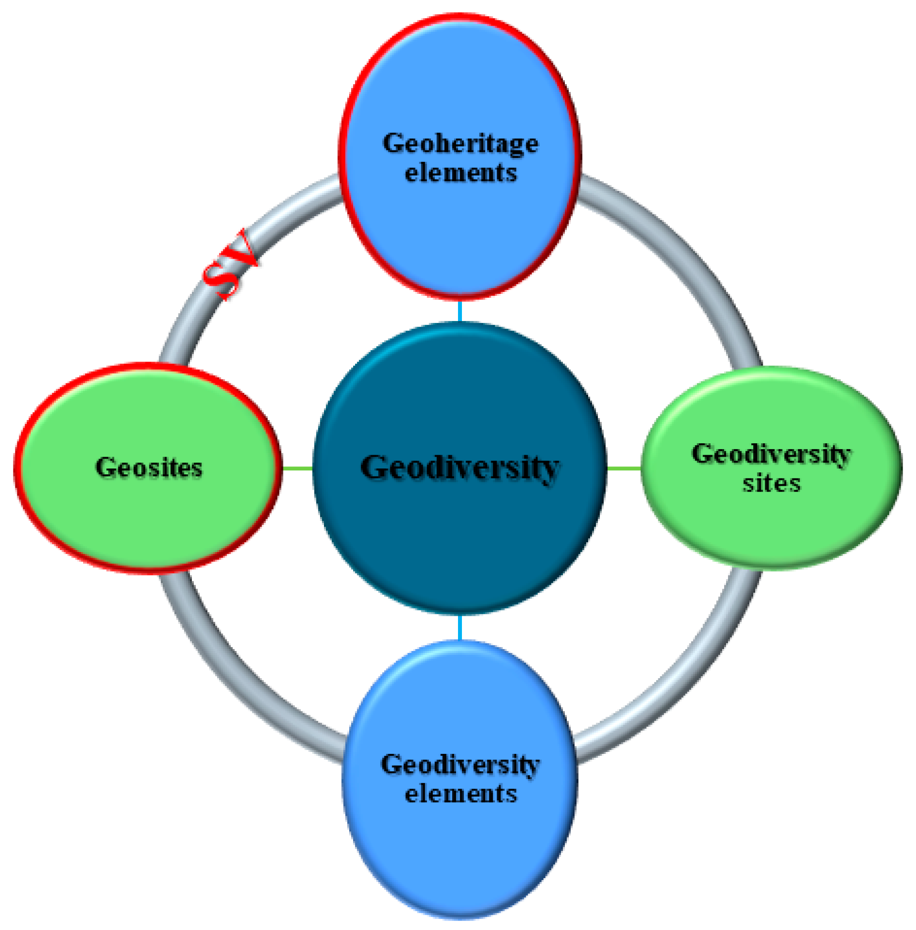
In the geoheritage framework, four different aspects of the geodiversity may be distinguished [1] (Figure 1):
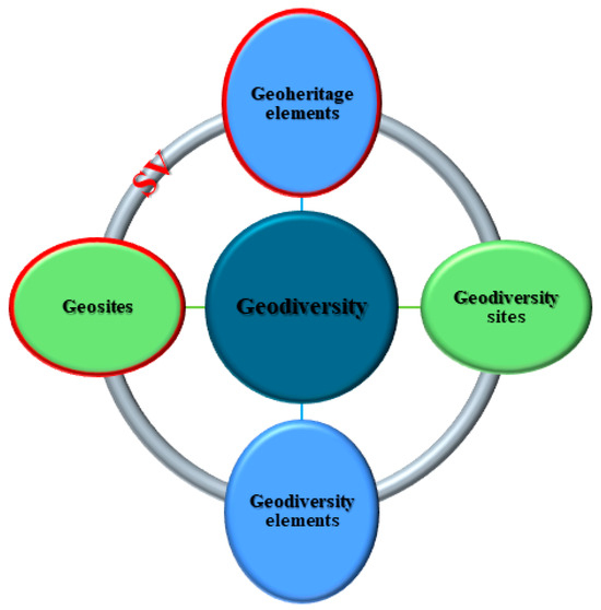
Figure 1.
Scheme of the Geodiversity [1]: Geosites and geodiversity sites (both in situ, green color). geoheritage elements and geodiversity elements (both ex situ, sky blue color). Geosites (in situ) and geoheritage elements (ex situ) must be provided with a high scientific value (SV).
- (1)
- Geosites;
- (2)
- Geodiversity sites;
- (3)
- Geoheritage elements;
- (4)
- Geodiversity elements.
The geosites and the geodiversity sites are specific geographical areas that include fossils, minerals, rocks, stratigraphic formations, morpho-structures, and landforms [6,7,8,9,10,11,12,13,14]. The geodiversity contained in the geosites must have significant geological and scientific importance, providing clear and unequivocal examples of the Earth’s geological history and evolution and also showing elements of rarity [1,6,7,8,9,10,11,12,13,14]. For this reason, geosites must be protected with priority with respect to geodiversity sites. Geosites may be important places for researchers, earth science memory, and geoconservation. Notwithstanding, if affected by a DR, these sites also if provided of high PEU or PTU values cannot be used for educational or touristic pourposes. In such cases, preservation and sustainable management will be the main priorities of the geoconservation actions. The main characteristic of a geosite is to be provided with high SV. Differently from the geosites, the geodiversity sites provided with high potential educational or touristic use values, but low DR, may be visited by stakeholders [1].
The geoconservation of geodiversity in situ [1,15,16,17,18,19,20,21,22,23,24] is mostly based on the knowledge of the geological background of the area and the scientific background reported in the literature [1].
The geodiversity inventory and quantitative assessment are basic activities carried out for geoconservation purposes. Various methods and approaches [1,25,26,27,28,29,30,31,32,33,34,35] were developed for distinguishing geosites from geodiversity sites. The authors focused on the method reported in Brilha [1].
The geodiversity inventory should mainly consider four aspects: (a) the topic, (b) the value, (c) the scale, and (d) the use [1]. The inventory of geosites, being based on significative scientific value, should evidence sites provided of geodiversity characterized by elevated representativeness, integrity, rarity, and scientific knowledge. Differently, the inventory of geodiversity sites, being useful for educational and touristic purposes, should evidence localities provided of elevated scenery, interpretative potential, accessibility, and safety conditions.
The geodiversity’s quantitative assessment is widely accepted for evaluating the scientific, educational, and touristic potential of the geosites and geodiversity sites, as well as the degradation risk.
The method for the geodiversity’s quantitative assessment evaluates the following four criteria: SV, PEU, PTU, and DR (Table 1).

Table 1.
The criteria SV, PEU, PTU, and DR (with scores) and related indicators (with percentages) used in Brihla [1].
Specific indicators are used for each criterion, namely SV, PEU, PTU, and DR (Table 1). These constitute seven, twelve, thirteen, and five indicators, respectively (Table 1). The score for each SV indicator can receive 1, 2, or 4 points, whereas the score for PEU, PTU, and DR indicators can receive 1, 2, 3, or 4 points. If there are no data available, the criterion is scored as 0 (Table 1).
The indicator sum, for each criterion and on the base of the ranking attributed to the indicators and related weights (%), is finally multiplied for factor 100 (Table 1). Three different categories (low, medium, or high; Brilha [1]), based on the score interval attributed to each criterium may be distinguished.
In particular, according to the adopted method, the geodiversity should be characterized by high SV with a score interval ranging from 301 to 400 (Table 2), or by moderate–low SV with a score interval ranging from 300 to 0, to be classified as geosites or geodiversity site, respectively.
Table 2.
Types of geodiversity in situ on the base of the SV.
More information on the method can be found in Brilha [1].
2.2. Classification of Coastal Lagoons
Coastal lagoons and lakes cover 13% of the coastlands worldwide [36]. These sites are significantly vulnerable to Global climate change, given that most of them developed on low–relief coasts. Along the Italian marine coasts, approximately 8300 km long, the coastal lagoons facing the Mediterranean Sea are numerous (as the Venice lagoon, the Cape Peloro and Marinello lagoons at Messina, the Salina Monaci lagoon at Taranto, the Fogliano and Caprolace lagoons at Latina, the Lesina lagoon at Foggia, the Miseno, and the Lucrino, Fusaro, and Patria lagoons at Naple).
According to Lankford [37] a coastal lagoon is defined as “a coastal zone depression below MHHW” (mean higher high water), “having permanent or ephemeral communication with the sea, but protected from the sea by some type of barrier”. Most coastal lagoons may be oriented parallel to the coast, such as the Sicilian Lake Ganzirri or the Latium Caprolace lagoon.
The classification of the coastal lagoons is based on the origin of the depression and barrier typology. Lankford [37] distinguished the following five classes:
- I.
- Differential Erosion;
- II.
- Differential Terrigenous Sedimentation;
- III.
- Barred Inner Shelf;
- IV.
- Organic;
- V.
- Tectonic–Volcanic.
The origin of most of the coastal lagoons depends on two or more basic classes, but the lagoons belonging to classes I–IV are the most diffused coastal bodies of brackish waters [37]. In the Italian coasts, most of the lagoons originated because of sedimentary processes, as in the case of Lake Patria [38].
Consequently, the tectonic coastal lagoons (class V [37]) are uncommon elements of geodiversity. Most of them originated by means of faults affecting high–relief coasts, bounded by discontinuous or continuous high–relief barriers due to uplifted blocks. In the Pacific Ocean, the Bahia Magdalena and Bahia Almejas are two examples of Mexican tectonic coastal lagoons with NW–SE trending narrow shapes. These lagoons are bounded by high-relief barrier islands controlled by a system of NW–SE trending normal faults, parallel to the lagoon lengths and the coast [37]. In the Mediterranean Sea, other two tectonic control coastal lagoons may be found in Morocco and Greece [39,40]. In particular, the Moroccan Lagoon Nador was developed on a low–relief coast with a NW–SE trending narrow shape and interpreted as due to the Neogene activity of fault systems oriented orthogonally with respect to the body of water length and coast [39].
3. Geological and Structural Setting
The CPCL is located in the low–relief coastal plain present on the NE edge of the Peloritani Mountains (Figure 2). The Peloritani chain is formed by a thrust pile (Figure 2) extending from Cape Peloro to the Taormina–Sant’Agata tectonic line [41,42,43,44]. The units are mainly composed of Variscan crystalline rocks [42,43,44,45,46,47,48,49,50] and some of them preserve remnants of Mesozoic–Cenozoic sedimentary covers [50]. Basements are made up of intrusive and metamorphic rocks showing high- to low-grade Variscan metamorphism, from the top to the base of the thrust pile [42]. An exception is represented by the Alì–Montagnareale Unit, being composed of a post-Varican sequence affected by Alpine anchimetamorphism [50] or by the Aspromonte and Mela Units, being devoid of sedimentary cover [41,42]. The thrust pile is sealed by thrust-top deposits, which are middle–upper Burdigalian in age [42]. The strong late Miocene post-orogenic uplift of the chain, which is still active, enhanced a significant erosion of the crystalline rocks and the consequent deposition of siliciclastic sediments [41].
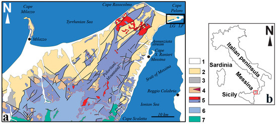
Figure 2.
(a) Geological and structural sketch map of the NE area of the Peloritani Mountains (NE Sicily) showing the localization of the CPCL (delimited by the black rectangle) with the Lake Faro (LF) and the Lake Ganzirri (LG) (areas in sky blue color). Legend: (1) Alluvial and coastal deposits (Holocene). (2) Miocene–Pleistocene sedimentary successions (including the Pleistocene Messina Fm.). (3) Floresta calcarenites (Langhian–upper Burdigalian) and Antisicilide Complex (lower Miocene–upper Cretaceous). (4) Stilo–Capo d’Orlando Fm. (Burdigalian). (5) Aspromonte Unit (a: Variscan metamorphic basement; b: Plutonic basement). (6) Mela Unit (Variscan metamorphic basement). (7) Mandanici–Piraino Unit (Variscan metamorphic basement and Mesozoic cover). (b) Localization of the geological and structural sketch map (red square). The map was modified after [51].
The CPCL faces the natural split–peninsula of Cape Peloro, a triangular-shaped coastal area bounded by two coasts: the E–W trending Tyrrhenian coast and the ENE–WSW trending Ionian coast (Figure 2). The CPCL represents the ending edge of the Strait of Messina [51,52] and its substrate is formed of Quaternary siliciclastic deposits represented by lower to middle Pleistocene deltaic–marine sediments (the Messina Fm.) and middle to upper Pleistocene marine terraces [53] (Figure 2). These latter also compose the hills surrounding the lagoon and the substrate of the Strait of Messina, as shown by offshore seismic profiles [54].
The CPCL
The CPCL is included in the densely populated coastal villages of Ganzirri and Torre Faro. The coastal lagoon mainly consists of brackish water basins with remnants of sand dunes. Nowadays, the existing basins are two, the coastal LF and LG. These are included in the lagoon and are officially considered a unique brackish environment with distinctive geological morpho-structures, flora, and fauna (a sanctuary for migratory birds and endemic mollusks).
The LF is a small brackish coastal lagoon with a sub-circular/octahedral shape. Its surface extends for about 263,600 m2 with a maximum depth of about 28 m on the eastern side of the lake. Two canals connect the brackish waters of the LF with the Ionian and Tyrrhenian Sea. Another canal connects the two lakes.
The LG is a narrow brackish coastal lagoon with an ENE–WSW trending elongated shape, parallel to the Ionian coast. The area is subdivided into two sub-basins covering a surface of about 338,400 m2. The LG shows a 7 m maximum depth and receives both underground and Sea waters, the latter are from two canals connected with the Ionian Sea.
Before the 1800, the lakes were not connected to the sea and a third lake, the Lake Margi (marsh), existed among the LF and LG. During the successive construction of the canals, the Lake Margi was infilled by the dug sediments and reclaimed. In the past, a salina extended in the western side of the LF and among the two sub-basins of the LG.
For the natural peculiarities and rarities, since 1979, the CPCL was included in the Special Protection Zones (Directive of the European Commission, 79/409/CEE [55]) and in 1992 in the Sites of Community Importance (Directive of the European Commission, 92/43/CEE of 21 May 1992 [56]) (Rete Natura 2000). In addition, the CPCL was also declared, according to declaratory provision 1342/88, “Heritage of ethnic–anthropological interest”, due to traditional working and productive activities related to aquaculture, specifically mussels, clams, and cockles farming.
The CPCL belongs to several different private owners, but after 2001, when it was also established as an Oriented Natural Reserve by the Regional Administration of Sicily, it was managed by the Metropolitan City of Messina [57].
Finally, since 2015, after the disposals of the Sicilian Region, the geodiversity contained in the CPCL was ascribed to two areal geosites (Figure 3), the only ones to be considered of Global interest in the insular territory of Messina. For their significant morpho–tectonic scientific value and uniqueness, the following geosites were denoted:
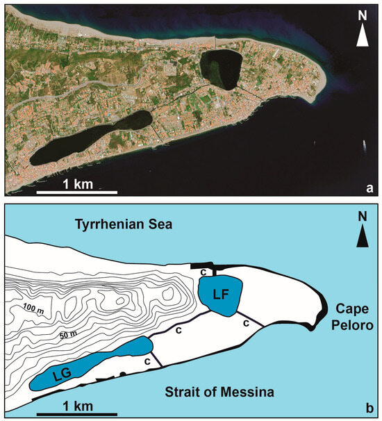
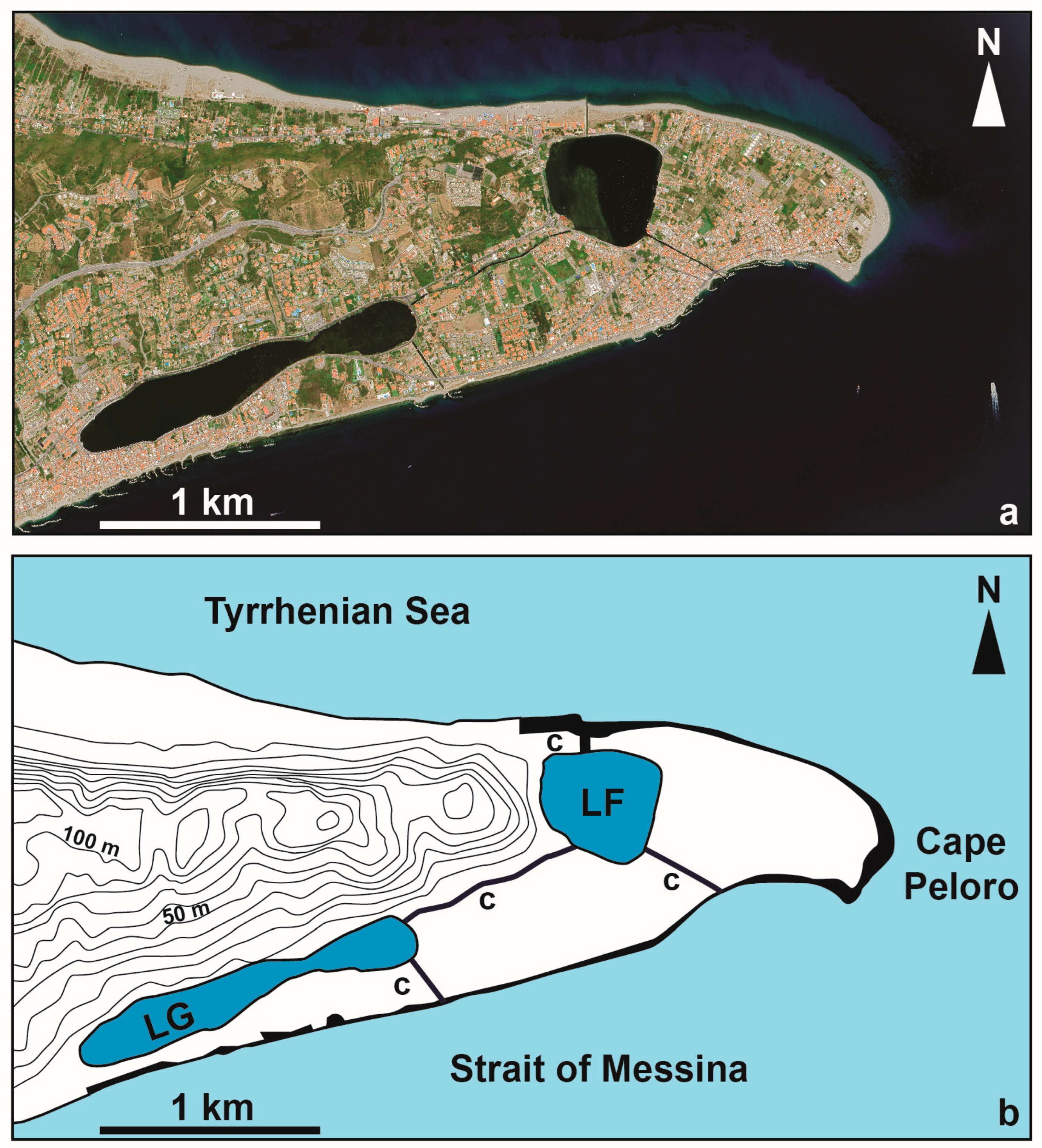
Figure 3.
CPCL. (a) Satellite image (Google Earth Pro, image date: 11 July 2023). (b) Map showing the CPCL zones of the reserve (LF and LG reported in the dark blue area) and pre-reserve (beach and c: canals reported in the black area).
- The “Morpho–tectonic system of Cape Peloro–Lake Faro”;
- The “Morpho–tectonic system of Cape Peloro–Lake Ganzirri”.
4. Results
4.1. CPCL Geodiversity: Geological and Structural Framework
Considering that the CPCL originated in the last 16,000 years B.P. [58], the main scientific value of both lakes concerns issues related to the Quaternary geology, including morpho-tectonics and capable faults. Indeed, the LF and the LG (Figure 4) developed within the lagoon during the post-Wurmian sea-level rise, and the associated strong extensional tectonics affecting the Calabria–Peloritani Arc since upper Pliocene–Pleistocene and still active [59,60,61,62,63,64,65,66,67,68,69,70,71,72,73,74,75,76].
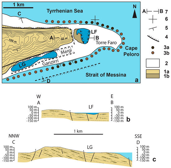
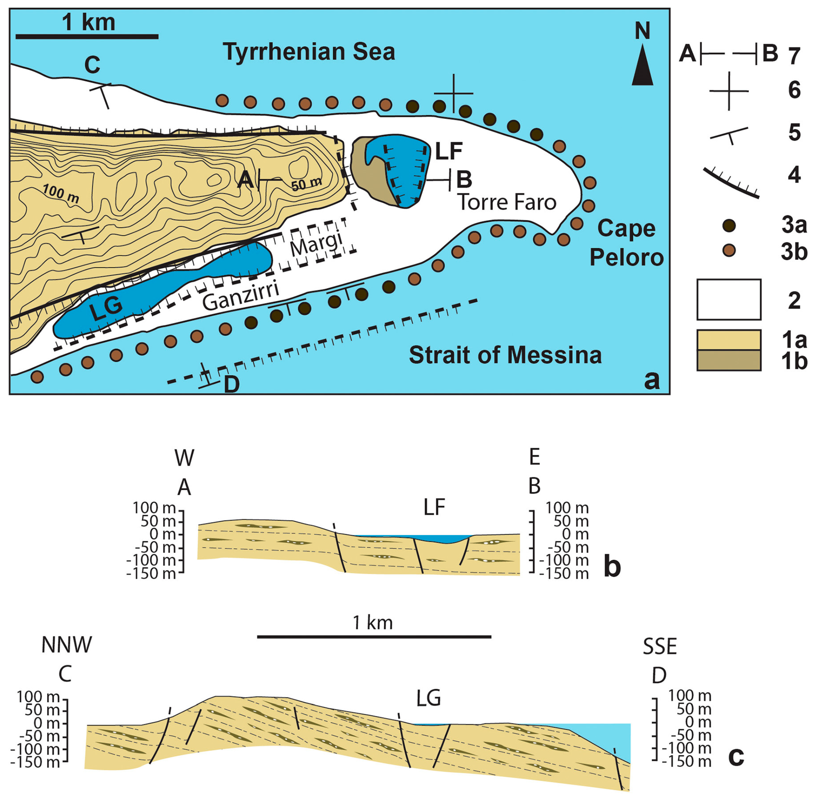
Figure 4.
(a) Geological sketch map of the Cape Peloro peninsula. (b) E–W trending geological cross-section of the LF (section A–B). (c) NNW–SSE trending geological cross-section of the LG (section C–D). A previous basin, interposed between the two lakes and reclaimed in the past, was present on the Margi area. For the localization of the sections, see Figure 4a. For the localization of the offshore and onshore faults, see [54,64]. Legend: 1a: Sands and gravels of the Messina Fm. (lower–middle Pleistocene) and marine terraces (upper Pleistocene). 1b: Sands and gravels of the Messina Fm. (lower–middle Pleistocene) covered by siliciclastic silty sands, in the platform of the LF. 2: Coastal deposits (Holocene). 3a: Beachrock (6 ka B.P.) on the sea bottom or exposed on the beach. 3b: Beachrock (6 ka B.P.) covered by modern marine sands and gravels. 4: Normal fault (traits in the hanging wall). 5: Horizontal bedding. 6: Dipping bedding. 7: Cross section.
The stratigraphy of the Cape Peloro coastal deposits, reconstructed in drilling, is characterized by siliciclastic sediments mainly composed of Holocene to modern grey sands and silty fine to medium sands [61].
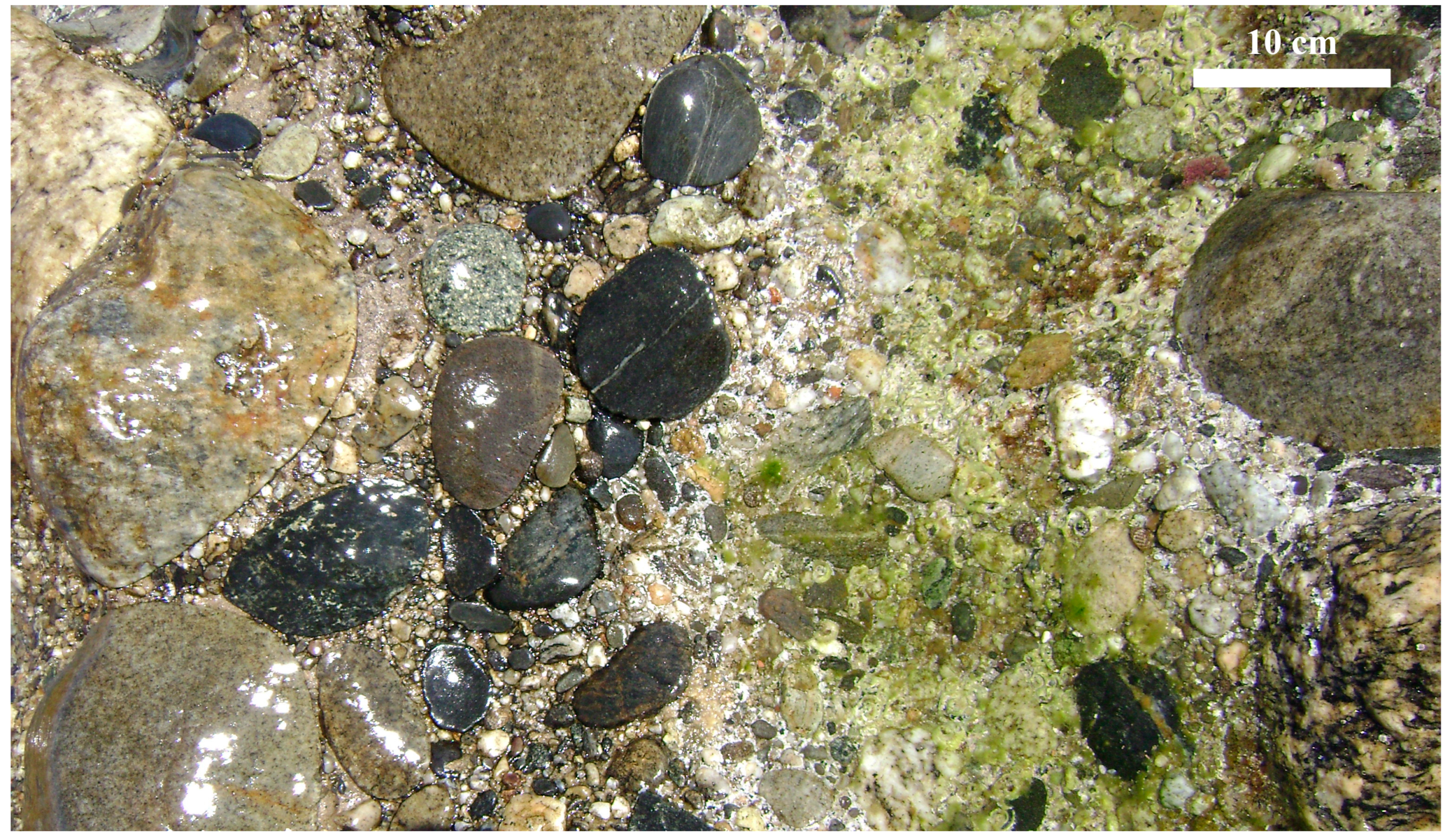
A layer of hard rocks (dated 6 ka B.P. [58]) interpreted as beach rocks [58,59] (Figure 5), i.e., sediments cemented by calcareous minerals rapidly formed within warm temperate to tropical intertidal zones, is exposed along an extensive shore–parallel belt extending for tens of kms, between 0.70 m a.s.l. and the isobath—2 m [55], partially covered by modern beach deposits (Figure 4a).

Figure 5.
Mesoscale photograph of the beachrocks outcropping nearshore on the beach of the Ganzirri village (38°15′33.67″ N; 15°37′27.66″ E). The rocks are hard conglomerates composed of high-grade metamorphic and igneous pebbles and boulders in a sandy matrix with calcareous cements.
The belt may be observed at least from Mortelle (38°16′16.11″ N; 15°37′53.97″ E), in the Tyrrhenian coast, to the Port of Messina, in the Strait of Messina, where evidence of the extraction activity of hundreds of millstones (38°11′28.22″ N; 15°34′23.96″ E) was found. Fieldwork on the Cape Peloro peninsula outcrops of beachrocks, actually the object of ongoing research, allowed us to establish that rocks are crossed by a system of joints and characterized by peculiar bedding attitudes, being horizontal in the Tyrrhenian coast and weakly SSE-dipping, between Torre Faro and Ganzirri, in the Strait of Messina (Figure 4a). Preliminary data on this unusual architecture could suggest the occurrence in the last millennia of a weak deformation hypothetically associated with the activity of the ENE-WSW capable normal faults widespread in this highly seismogenic sector of the Calabria-Peloritani Arc [60,61,62,63,64,65,66,70,71].
4.2. Inventory
The geological elements and phenomena allowing reconstruction of the geological history and evolution of a particular site represent the basic framework of potential geosites. The geological framework present in the LF and LG is centered on the topic of Quaternary extensional tectonics and the consequent formation of morpho–tectonic depressions hosting a lagoon with brackish waters.
Lacking a scientific inventory (at the moment of the official requests of the authors to the competent institutions) supporting the denomination of “Morpho–tectonic system of Cape Peloro–Lake Faro” and “Morpho–tectonic system of Cape Peloro–Lake Ganzirri”, evidence of the tectonic origin of the two coastal lakes were searched in the scientific literature and in ongoing research carried out by the authors [58,59,64].
Extensional fault systems shaped the landscape of the peninsula and the surrounding onshore and offshore. Horst and demi-horst characterize the Peloritani Mountains, as the Ganzirri horst denoted by Guarnieri and Pirrotta [68]. Graben and demi-graben predominate offshore, in the Strait of Messina [54]. The complex array of faults affecting the Messina area was reconstructed by the research of Ghisetti [61], a milestone of the structural geology of the Messina Strait area. The fault framework may be grouped into the following main macroscale systems:
- i.
- The ENE–WSW trending normal faults (about two main faults denoted n. 63 and 66 in [61]);
- ii.
- The NNE–SSW trending normal faults (about 15 main faults denoted n. 45–60 in [61]);
- iii.
- The NW–SE to E–W trending faults (about eight main faults denoted n. 61, 62, 64, 65, 66, or without number in [61]).
All these faults were considered extensional faults, except the NW–SE trending faults. Indeed, a right lateral component was identified in these faults, interpreted as relay zones [75], and reported in several structural and seismotectonic maps of the NE Sicily and southern Calabria [61,67,75].
The tectonic origin of the LF was reported in the 1952 [59]. After half a century, Bottari et al. [64] confirmed the tectonic evolution for the LF, but no further structural data were provided.
An unpublished structural investigation, carried out by one of the authors (R.S.) in the Messina Formation gravels exposed in the hills surrounding the CPCL, allowed us to identify tens of mesoscale faults. These mesoscale structures, never detected until now because it is difficult to provide evidence for the incoherent nature of the deposits, confirmed the presence of the three main above-mentioned macroscale systems [76]. The main fault kinematic indicators were drag folds allowing us to identify cm–scale normal type displacements in the ENE–WSW, NNW–SSE/NW–SE, and E–W trending mesoscale faults. A right lateral transtensional movement was reported in [67,68,75] for the NNW–SSE/NW–SE faults. This oblique component cannot be confirmed or excluded in the CPCL area, due to the difficulties in identifying the kinematics of brittle deformation on Quaternary incoherent deposits.
4.2.1. LF
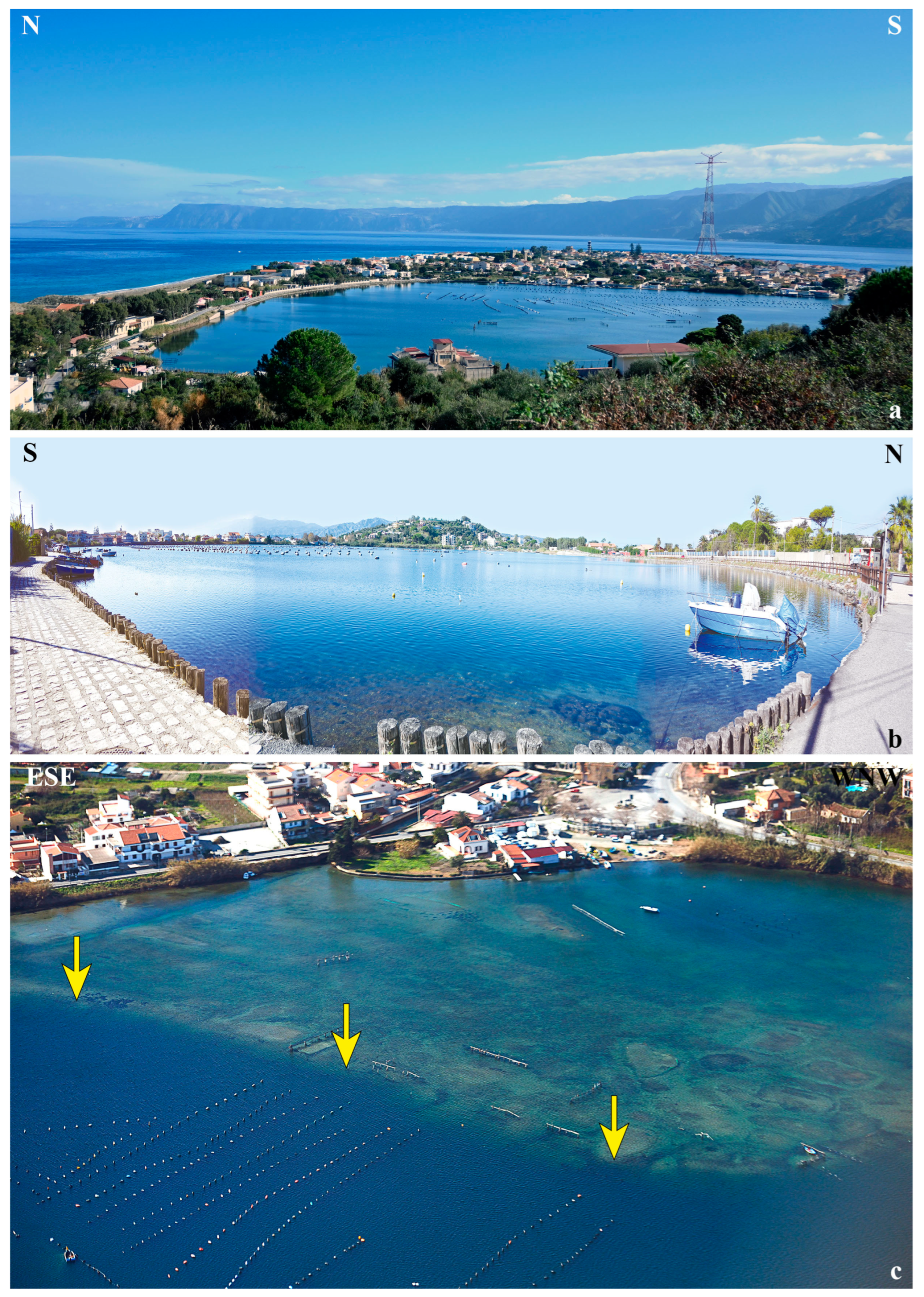
The geodiversity present in the LF (Figure 6, Table 3) is represented by a peculiar funnel-shaped depression. This latter is very deep and represents the deepest lake in the insular territory. A depth of about 28 m versus a diameter of about 645 m determines a lake amplitude/depth ratio equal to 1:23. The lake’s western side bounding the depression is a very shallow sub-horizontal platform at a 2–3 m depth.

Figure 6.
Lake Faro. (a) View of the lake from the surrounding hill. (b) View of the lake from the surrounding path. (c) Aerial photograph (courtesy Daniele Passaro) of the lake showing the western shallow platform delimited by the fault scarp evidenced by the yellow arrows.
Table 3.
Synthetic inventory of the geosite Lake Faro.
The genesis of the LF depression was interpreted as due to morpho–tectonics [55,56,61]. The LF is bounded at the west by a hill, about 60 m high, crossed by a steep NW–SE trending fault, NE dipping [61] (Figure 4a,b). Field and satellite imagery observations on this fault scarp allowed us to identify a trapezoidal facet compatible with a high-angle normal fault. This fault could be associated with a fault system responsible for the origin of the tectonic depression (graben) present on the eastern side of the LF.
The NW–SE trending fault system is also reported in the official database of active capable faults of the Italian territory, reported by the ISPRA in the project ITHACA (ITaly HAzard from CApable faulting) [77].
4.2.2. LG
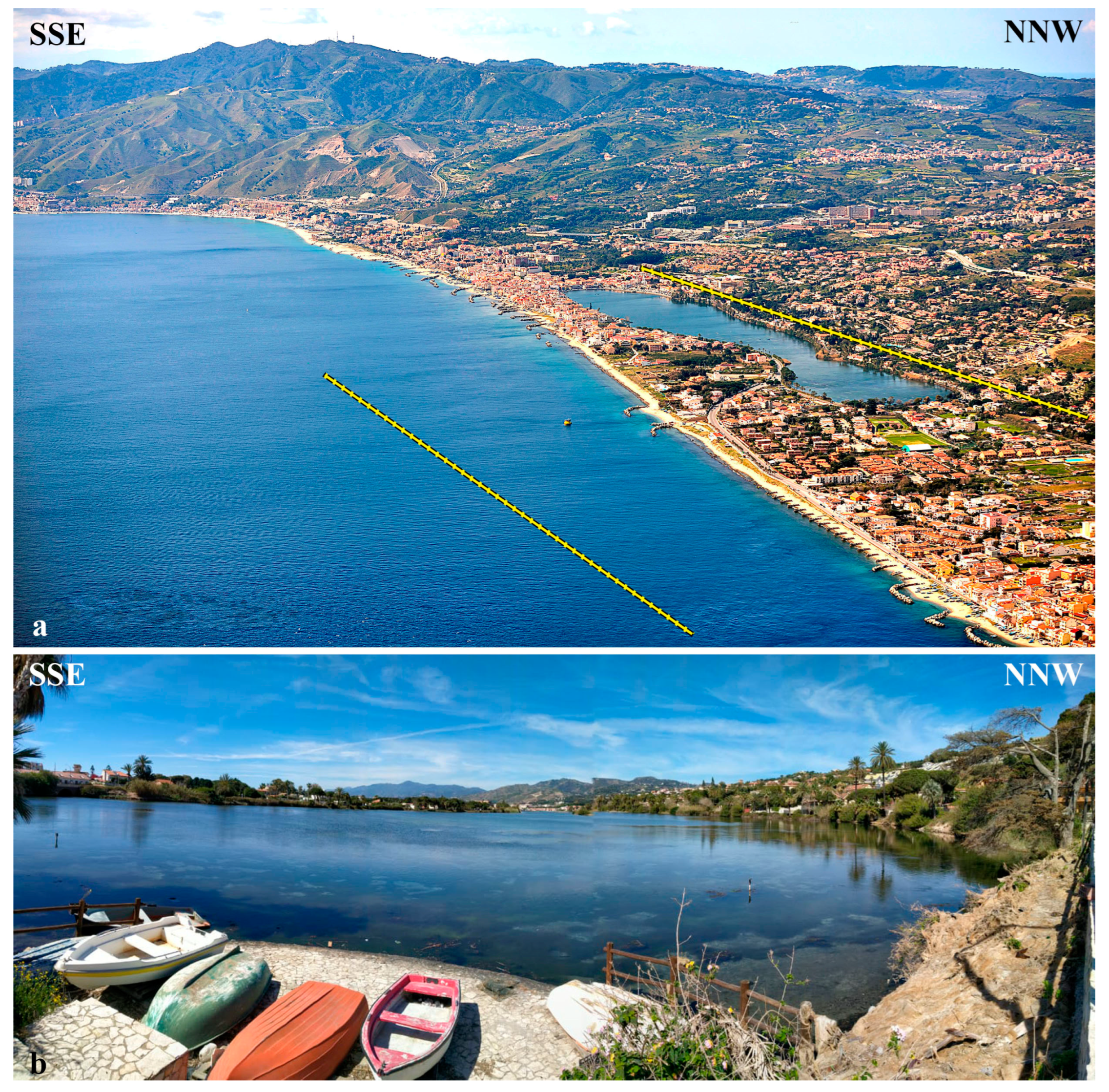
The geodiversity present in the LG is represented by the morpho–tectonic origin of the coastal lake. The lake has an elongated shape parallel to the Ionian coast (Figure 7, Table 4).

Figure 7.
Lake Ganzirri. (a) Aerial photograph (courtesy of Daniele Passaro) of the lake. The faults of the Scilla–Ganzirri system are evidenced by the yellow line. (b) View of the lake from the surrounding path.
Table 4.
Geodiversity synthetic inventory of the Lake Ganzirri.
An ENE–WSW trending and SSE dipping normal fault was reported for the first time in 1992, in the simplified structural map of the Messina Strait [61]. This fault bounds the NNW side of the LG lagoon platform (Figure 4a,c). The existence of this normal fault was also demonstrated by means of an onshore seismic profile [64] (Figure 4a,c). Offshore seismic profiles also demonstrated the presence of an analogous ENE–WSW trending and SSE dipping normal fault, parallel to the Ionian coast and crosscutting the sea bottom [54] (Figure 4a,c). This system is also reported in the official database of active capable faults of the Italian territory, reported by the ISPRA in the project ITHACA [77]. Field and satellite imagery observations in the fault area allowed us to recognize the landscape’s triangular to trapezoidal facets, compatible with a normal displacement. Unpublished data on structural analyses carried out on mesoscale faults allowed us to identify tens of ENE–WSW trending normal faults in the gravels of the Messina Formation showing typical kinematic indicators of extension (normal drag folds). These capable meso- and macroscale faults belong to the ENE–WSW trending normal fault system of Scilla–Ganzirri [68] and are responsible for shaping this sector of the Strait of Messina.
On the base of the parallelism of the Ionian coast with the normal fault system of Scilla–Ganzirri, a morpho–tectonic control for this sector of the coast was evident [68]. As a consequence, the LG is a coastal lake formed under morpho–tectonic control of the ENE–WSW normal faults. The barrier bounding the LG may be interpreted as a small size horst structure.
4.3. Quantitative Assessment of the LF and LG
The SV, PEU, PTU, and DR of the geodiversity present in the LF and LG were evaluated.
4.3.1. Scientific Value (SV)
The morpho-structures related to the LF and LG represent the geodiversity actually protected in the two Global geosites of Cape Peloro.
The morpho-structure responsible for the genesis of the LF developed in a low-relief coast, bounded by a system of NW–SE trending capable normal faults (Figure 4a,b). Differently from other morpho-structures (the Mexican Bahia Magdalena and Bahia Almejas Lagoons, the Moroccan Nador Lagoon, and the Greek Papas Lagoon), the LG morpho–structure is provided by significant elements of rarity, being small the number of tectonic coastal lagoon developed in a low–relief coast, parallel to the coast.
The quantitative assessment of the SV, based on the seven indicators adopted from Brihla [1], indicated that the geodiversity present at the LF and LG is provided of high scientific value (weighted values between 301 and 400) (Table 1, Table 2 and Table 5). The maximum scores were attributed to four indicators (representativeness, key locality, geological diversity, and rarity) (Table 5). Indeed, the morpho-structures contained in the geosites resulted in elements of rarity provided with significant geological and scientific importance, being clear and unequivocal examples (or models) able to represent the Earth’s geological history and evolution of the Quaternary tectonic coastal lagoons. Moreover, the occurrence of another geodiversity element with high scientific interest, represented by the beachrocks presumably deformed during the active extensional tectonics (officially not included in the geosites), should further increase the SV of the geosites, being small the number of beachrocks globally widespread.
Table 5.
Geodiversity quantitative assessment of the SV (the number between round brackets represents the relative weight %). See [1] for the explanation of the indicators.
4.3.2. Potential Education Use (PEU)
The quantitative assessment of the PEU, based on the 12 indicators from Brihla [1], indicates that the geodiversity at the LF and LG is provided of high potential educational use (weighted values between 301 and 400) (Table 1, Table 2 and Table 6).
Table 6.
Geodiversity quantitative assessment for the PEU (the number between round brackets represents the relative weight %). See [1] for the explanation of the indicators.
The maximum scores were attributed to 10 indicators (accessibility, safety, logistics, density of population, association with other values, scenery, uniqueness, observation conditions, didactic potential, and geological diversity). Indeed, the lakes are near the bus station stops and are located in populated sites with accommodation facilities, low-risk conditions for the stakeholders. The beauty of the scenery is elevated along both lakes, but it can be further appreciated by panoramic views reaching the surrounding hills. The high number of geodiversity elements (faults and beachrocks) associated with the significant value of the bioheritage (flora and fauna, sanctuary for migratory birds, and endemic mollusks) and ethno-anthropological traditions (traditional mollusk culture) make the geosites very useful for geoeducation purposes.
4.3.3. Potential Touristic Use (PTU)
The quantitative assessment of the PTU, based on the 13 indicators adopted from Brihla [1], indicates that the geodiversity present at the LF and LG is characterized by high PTU (weighted values between 301 and 400) (Table 1, Table 2 and Table 7).
Table 7.
Geodiversity quantitative assessment of the PTU (the number between round brackets represents the relative weight %). See [1] for the explanation of the indicators.
The maximum scores were attributed to 10 indicators (accessibility, safety, logistics, density of population, association with other values, scenery, uniqueness, observation conditions, interpretative potential, and proximity of recreational areas). In addition to the indicators in common with the PEU, the ease in illustrating the structures to tourists without a geological background together with the proximity of recreational areas and touristic attractivities (beach of Cape Peloro, Saracen towers, cultural foundations, scuba diving and sport centers, resorts, and several hotels, restaurants, and bars) make geosites important attractions for the geotourism.
4.3.4. Degradation Risk (DR)
The quantitative assessment of the DR, based on the five criteria adopted from Brihla [1], indicates that the geodiversity present at the LF and LG is provided of a high DR (weighted values between 301 and 400) (Table 1, Table 2 and Table 8). The high scores were mainly influenced by the proximity of the lakes to vehicular traffic roads and the vulnerability to anthropic actions (tourism, urban development, and planned mega-infrastructures).
Table 8.
Geodiversity quantitative assessment of the DR (the number between round brackets represents the relative weight %). See [1] for the explanation of the indicators.
5. Discussion and Conclusions
5.1. The Quantitative Assessment of Geodiversity
The quantitative assessment of geodiversity based on the Brihla method [1] (Table 5, Table 6, Table 7 and Table 8) indicated high scores for the SV, PEU, PTU, and DR (Table 9).
Consequently, the LF’s and LG’s geodiversity resulted in a geosite, being the SV provided with high score in both sites (Table 5 and Table 9). Indeed, the study morpho-structures resulted in key localities provided with SV indicators of representativeness, geological diversity, and rarity, to protect with priority, being clear and unequivocal examples of the Earth’s geological history and evolution of the Quaternary tectonic coastal lagoons. Regardless, activities for further improvement in the SV and the reduction in the DR could be carried out in the near future for the consequent relapses. The SV could benefit from an increasing score for scientific knowledge, given that the papers dedicated to this geodiversity are actually very scarce. For reducing the DR, the indicators “Proximity to areas/activities with potential to cause degradation” could be reduced in value, implementing the actions to reduce the cause of environmental degradation (for example, allowing vehicular traffic only to electricity cars and boats at low environmental impact) and increasing the activities of control of the competent authorities to protect geodiversity and biodiversity (for example, with the installation of permanent video cameras). In such a way, the consequences of poaching fishermen, notwithstanding the interdiction to fish, could be better contrasted.
With regard to the scenery of the lagoon, the LF could especially improve the level of quality if the actual structures used by the mollusk farmers (such as buoys, poles, and ropes) were substituted by smallest size and/or impacting materials.
From an environmental point of view, the necessity to dispose of several actions to reduce/solve different criticisms found in the CPCL arose. A major control of the discharge waters in the lakes should be necessary. The construction and demolition materials (bricks and tiles) illegally abandoned in the past along the accessible lake coasts should be removed especially in the LF bottom. It seems useful to underline that recent research carried out in the CPCL pre-reserve areas (Ionian and Tyrrhenian coasts) reported the occurrence in the beach deposits of significant amounts of asbestos cement fragments associated with construction and demolition materials, especially on the Ionian coast [51,52].
Finally, the significant geodiversity recognized along the coast of the natural oriented reserve of Cape Peloro and represented by deformed beachrocks, due to their rarity, could be included in the geoheritage management and inventoried in the geosites of the CPCL, extending the protection of the coastland also sea-ward, nearshore.
5.2. Geoeducation and Geotourism
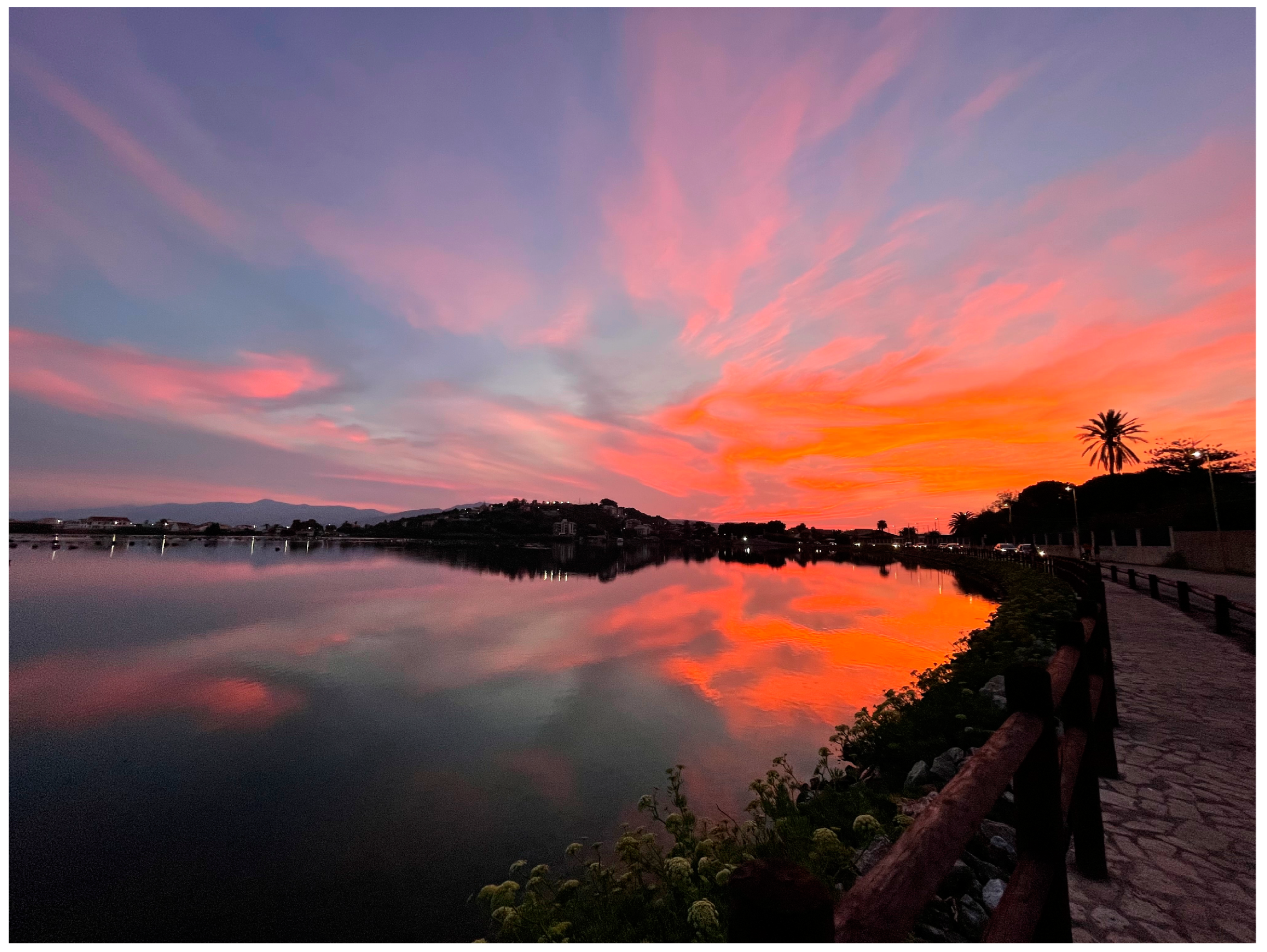
In the future, it could be possible to improve activities devoted to geoeducation and geotourism, considering the high scores of the PEU and PTU of the study LF and LG. Both uses could benefit from dedicated panoramic sites for observing the impressive scenery of the lakes (Figure 8).

Figure 8.
Lake Faro. Scenery of the lake during the sunset (W-wards view).
Panoramic locations to observe the geosite morpho-structures could be planned on the neighboring hill (LF: at 55 m a.s.l. in proximity of the five–a–side football field, coordinates 38°16′8.36″ N–38°16′8.36″ N; LG: at 80 m a.s.l. in proximity of the panoramic street, coordinates 38°15′59.13″ N–15°36′57.38″ E). Wooden turrets could be disseminated along the perimeter of both lakes. In particular, the capable fault present in the LF could be observed by researchers, students, and tourists from these turrets or along the existing pathway surrounding the lake. Observations could be also carried out during rowing boat trips or snorkeling/scuba diving activities at low impact along the fault scarp for limited numbers of stakeholders (if agreed and permitted by the director of the reserve).
Analogously, different geotrails could be also planned along the Ionian and Tyrrhenian shoreline, in order to observe the beachrocks cropping out from Torre Faro to Ganzirri onshore or snorkeling/scuba diving activities to observe the submerged beachrocks (Figure 4a). These activities could be also extended in the surroundings of the Messina port, where evidence of the ancient extraction of mills of beachrocks is evident.
Finally, a geoeducation and geotouristic center organized by the University of Messina with the cooperation of both the reserve and the environmental associations could be planned to promote the bio–geodiversity of the lagoon, disseminating their knowledge.
5.3. Criticisms and Risks for the Geoheritage
The main risks of deterioration, degradation, and vulnerability are related to anthropic actions.
The Messina bridge project that is under planning procedures in the natural protected reserve of CPCL represents an actual serious criticism of the geoconservation of the study geoheritage. Urgent actions should be necessary and strongly promoted by the competent authorities, especially at the EU scale, also with the support of the university researchers and the global governmental and non-governmental environmental organizations and agencies (UNESCO, International Union for Conservation of Nature, European Environment Agency, Coastwatch Europe, etc.) for the protection and conservation of the geo-biodiversity maintained in the LF and LG Global geosites of the coastal lagoon with the related marine and continental fauna and flora and the coupled ethno-anthropological traditions. The realization of such infrastructures in a protected area, further to being in contrast with the regulations and laws devoted to defending the protected natural areas and geo-biodiversity, would negatively modify the values of the indicators used for the quantitative assessment of the studied global geosites. Indeed, the existing natural balances between biotic and abiotic components can be altered by the construction of infrastructures which, in addition to the risks linked to the survival of the structure itself, entail a certain and perhaps irreversible modification of the natural equilibria.
The interdiction to build significant infrastructures in a protected area should be a normal conduct to be adopted in advanced countries. It also seems useful and proper to underline in this peculiar historical moment that in Italy, it is not permitted to construct in the proximity (respect zones) of the capable faults. In the project for the Messina bridge, the infrastructures on both sides of the Strait of Messina should fall in areas crossed by capable faults as reported by the ISPRA in the official database of active capable faults of the Italian territory (project ITHACA) [77]. One of these macroscale capable faults, belonging to the Scilla–Ganzirri normal fault system, bounds the Ionian coast just in front of the LG, as observed in the offshore seismic profiles by Doglioni et al. [54] (Figure 4a). Another macroscale capable fault belonging to the same system, observed in onshore seismic profiles [61], bounds the LG (Figure 4a,c). Moreover, recent data [76] and unpublished data that are the objects of an ongoing investigation showed the presence of a diffused array of mesoscale-capable normal faults affecting the Quaternary deposits present in the CPCL surroundings.
5.4. Final Remarks
The actual criticisms that could irreversibly affect the environmental equilibria as well as the existing risks and the possible actions of redevelopment of the CPCL should be seriously considered and faced.
Any geoconservation strategy is essential for geodiversity protection from environmental damages or anthropic aggressions, being vital for the dissemination of knowledge for the next generations of researchers, students, and stakeholders. The scores attributed to the SV indicators (representativeness, key locality, geological diversity, and rarity) of the CPCL justify the attribution of the LF and LG of the CPCL to Global areal geosites. The authors fully agree with the previous decision of the Sicilian Region to reserve the maximum level of protection for these sites and the establishment of the maximum priority in their management.
Moreover, evaluating that the LF and LG belong to the following:
- (i)
- Oriented Nature Reserves;
- (ii)
- Special Protection Areas (Directives of the European Commission);
- (iii)
- Sites of Community Importance (Directives of the European Commission);
- (iv)
- Assets of ethno-anthropological interest,
It seems opportune to consider the CPCL as a possible candidate for being included in the list of UNESCO natural sites. This action could strengthen their status of “untouchable natural heritage of the humanity”, further helping to prevent any future environmental/anthropic aggression/aggressiveness to the significant geo-biodiversity of the CPCL.
Author Contributions
Conceptualization, R.S., S.E.S. and S.G.; methodology, R.S., S.E.S. and S.G.; software, R.S.; validation, R.S., S.E.S. and S.G.; formal analysis, R.S., S.E.S. and S.G.; investigation, R.S., S.E.S. and S.G.; resources, R.S., S.E.S. and S.G.; data curation, R.S., S.E.S. and S.G.; writing—original draft preparation, R.S., S.E.S. and S.G.; writing—review and editing, R.S., S.E.S. and S.G.; visualization, R.S., S.E.S. and S.G.; supervision, R.S. All authors have read and agreed to the published version of the manuscript.
Funding
This research was not funded by institutional funds.
Data Availability Statement
Data are contained within the article.
Acknowledgments
The authors would like to thank the anonymous reviewers and the academic editors who strongly improved the paper.
Conflicts of Interest
The authors declare no conflicts of interest.
References
- Brilha, J.B. Inventory and Quantitative Assessment of Geosites and Geodiversity Sites: A Review. Geoheritage 2016, 8, 119–134. [Google Scholar] [CrossRef]
- Ispra Ambiente. Available online: https://www.isprambiente.gov.it/it (accessed on 5 March 2024).
- Gazzetta Ufficiale. Available online: http://www.gurs.regione.sicilia.it/Gazzette/g12-15o1/g12-15o1.pdf (accessed on 3 February 2024).
- Catalogo Regionale dei Geositi. Available online: https://dati.regione.sicilia.it/dataset/catalogo-regionale-dei-geositi (accessed on 5 May 2024).
- Ispra Ambiente. Available online: https://www.isprambiente.gov.it/contentfiles/00003700/3731-patrimonio.pdf (accessed on 14 July 2024).
- ProGEO. A first attempt at a geosites framework for Europe—An IUGS initiative to support recognition of World heritage and European geodiversity. Geol. Balc. 1998, 28, 5–32. [Google Scholar]
- Santangelo, N.; Santo, A.; Guida, D.; Lanzara, R.; Siervo, V. The geosites of the Cilento–Vallo di Diano national park (Campania region, southern Italy). Il Quat. Ital. J. Quat. Sci. 2005, 18, 103–114. [Google Scholar]
- Gray, J.M. Geodiversity: Developing the paradigma. Proc. Geol. Assoc. 2008, 119, 287–298. [Google Scholar] [CrossRef]
- Browne, M.A.E. Geodiversity and the role of the planning system in Scotland. Scott. Geogr. J. 2012, 128, 266–277. [Google Scholar] [CrossRef]
- Lagally, U.; Loth, R.; Schindelmann, C. The “day of Geosites” in Germany—A successful promotion tool for earth sciences. Geoheritage 2015, 7, 195–204. [Google Scholar] [CrossRef]
- Wang, L.; Tian, M.; Wang, L. Geodiversity, geoconservation and geotourism in Hong Kong Global Geopark of China. Proc. Geol. Assoc. 2015, 126, 426–437. [Google Scholar] [CrossRef]
- Kelley, D.; Salazar, R. Geosites in the Galápagos Islands used for geology education programs. Geoheritage 2017, 9, 351–358. [Google Scholar] [CrossRef]
- Barasoain, D.; Azanza, B. Geoheritage and education: A practical example from the Rhinoceros of Toril 3 (Calatayud–Daroca Basin, Spain). Geoheritage 2018, 10, 363–374. [Google Scholar] [CrossRef]
- Pardo-Igúzquiza, E.J.; Durán-Valsero, J.A.; Dowd, P.; Luque-Espinar, J.A.; Heredia, J.; Robledo-Ardila, P.A. Geodiversity of closed depressions in a high relief karst: Geoeducation asset and geotourism resource in the “Sierra de las Nieves” National Park (Málaga Province, Southern Spain). Int. J. Geoherit. Parks 2022, 10, 196–217. [Google Scholar] [CrossRef]
- Black, G.P.; Gonggrijp, G.P. Fundamental thoughts on Earth–science conservation. Jb. Geol. B-A 1990, 133, 655–657. [Google Scholar]
- Gordon, J.E. Geoconservation principles and protected area management. Int. J. Geoherit. Parks 2019, 7, 199–210. [Google Scholar] [CrossRef]
- Da Glória Garcia, M.; Queiroz, D.S.; Mucivuna, V.C. Geological diversity fostering actions in geoconservation: An overview of Brazil. Int. J. Geoherit. Parks 2022, 10, 507–522. [Google Scholar] [CrossRef]
- Wimbledon, W.A.P. GEOSITES—An International Union of Geological Sciences initiative to conserve our geological heritage. Pol. Geol. Inst. Spec. Pap. 1999, 2, 5–8. [Google Scholar]
- Brilha, J.B. Geoconservation and protected areas. Environ. Conserv. J. 2002, 29, 273–276. [Google Scholar] [CrossRef]
- Erikstad, L. History of geoconservation in Europe. In The History of Geoconservation; Burek, C.V., Prosser, C.D., Eds.; Geological Society London Special Publications: London, UK, 2008; pp. 249–256. [Google Scholar]
- Prosser, C.D.; Burek, C.V.; Evans, D.H.; Gordon, J.E.; Kirkbride, V.B.; Rennie, A.F.; Walmsley, C.A. Conserving geodiversity sites in a changing climate: Management challenges and responses. Geoheritage 2010, 2, 123–136. [Google Scholar] [CrossRef]
- Henriques, M.H.; Pena dos Reis, R.; Brilha, J.; Mota, T.S. Geoconservation as an emerging geoscience. Geoheritage 2011, 3, 117–128. [Google Scholar] [CrossRef]
- Gray, J.M. Geodiversity: Valuing and Conserving Abiotic Nature, 2nd ed.; Wiley-Blackwell: Chichester, UK, 2013; pp. 1–512. ISBN 978-0-470-74215-0. [Google Scholar]
- Prosser, C.D. Our rich and varied geoconservation portfolio: The foundation for the future. Proc. Geol. Assoc. 2013, 124, 568–580. [Google Scholar] [CrossRef]
- Joyce, E.B. Australia’s Geoheritage: History of Study, A New Inventory of Geosites and Applications to Geotourism and Geoparks. Geoheritage 2010, 2, 39–56. [Google Scholar] [CrossRef]
- Lima, F.F.; Brilha, J.B.; Salamuni, E. Inventorying geological heritage in large territories: A methodological proposal applied to Brazil. Geoheritage 2010, 2, 91–99. [Google Scholar] [CrossRef]
- Ruban, D.A. Quantification of geodiversity and its loss. Proc. Geol. Assoc. 2010, 121, 326–333. [Google Scholar] [CrossRef]
- Fassoulas, C.; Mouriki, D.; Dimitriou-Nikolakis, P.; Iliopoulos, G. Quantitative assessment of geotopes as an effective tool for geoheritage management. Geoheritage 2012, 4, 177–193. [Google Scholar] [CrossRef]
- Bollati, I.; Smiraglia, C.; Pelfini, M. Assessment and selection of geomorphosites and trails in the Miage Glacier Area (Western Italian Alps). Environ. Manag. 2013, 51, 951–967. [Google Scholar] [CrossRef]
- Pereira, D.I.; Pereira, P.; Brilha, J.; Santos, L. Geodiversity assessment of Paraná State (Brazil): An innovative approach. Environ. Manag. 2013, 52, 541–552. [Google Scholar] [CrossRef]
- Albani, R.A.; Mansur, K.L.; Carvalho, I.S.; Santos, W.F.S. Quantitative evaluation of the geosites and geodiversity sites of João Dourado municipality (Bahia—Brazil). Geoheritage 2020, 12, 63–74. [Google Scholar] [CrossRef]
- Ansori, C.; Setiawan, N.I.; Warmada, I.W.; Yogaswara, H. Identification of geodiversity and evaluation of geosites to determine geopark themes of the Karangsambung-Karangbolong National Geopark, Kebumen, Indonesia. Int. J. Geoherit. Parks 2022, 10, 1–15. [Google Scholar] [CrossRef]
- Najwer, A.; Jankowski, P.; Niesterowicz, J.; Zwoliński, Z. Geodiversity assessment with global and local spatial multicriteria analysis. Int. J. Appl. Earth Obs. Geoinf. 2022, 107, 102665. [Google Scholar] [CrossRef]
- Somma, R. The Inventory and Quantitative Assessment of Geodiversity as Strategic Tools for Promoting Sustainable Geoconservation and Geo-Education in the Peloritani Mountains (Italy). Educ. Sci. 2022, 12, 580. [Google Scholar] [CrossRef]
- Samodra, H.; Permanadewi, S.; Irzon, R.; Yunianto, B.; Ansori, C.; Junursyah, G.M.L.P.; Patriani, E.Y.; Maryanto, S. The geodiversity site of Sentono Gentong in Pacitan, Indonesia: Geological characteristics and quantitative assessment. Int. J. Geoherit. Parks 2024, 12, 196–208. [Google Scholar] [CrossRef]
- Barnes, R.S.K. Coastal Lagoons; Cambridge University Press: New York, NY, USA, 1980; pp. 1–120. [Google Scholar]
- Lankford, R. Coastal Lagoons of Mexico their origin and classification. In Estuarine Processes; Wiley, M., Ed.; Academic Press: Cambridge, MA, USA, 1977; pp. 182–215. [Google Scholar] [CrossRef]
- Sacchi, M.; Molisso, F.; Pacifico, A.; Vigliotti, M.; Sabbarese, C.; Ruberti, D. Late-Holocene to recent evolution of Lake Patria, South Italy: An example of a coastal lagoon within a Mediterranean delta system. Glob. Planet. Change 2014, 117, 9–27. [Google Scholar] [CrossRef]
- Raji, O.; Dezileau, L.; Tessier, B.; Niazi, S.; Snoussi, M.; Von Grafenstein, U.; Poujol, A. Climate and tectonic-driven sedimentary infill of a lagoon as revealed by high resolution seismic and core data (the Nador lagoon, NE Morocco). Mar. Geol. 2018, 398, 99–111. [Google Scholar] [CrossRef]
- Stamatopoulos, L.; Aiello, G.; Barra, D.; De Pippo, T.; Donadio, C.; Valente, A. Morphological and palaeoenvironmental evolution of the Lagoon of Papas, southwestern Greece, during the Holocene. Ital. J. Geosci. 2014, 133, 282–293. [Google Scholar] [CrossRef]
- Lentini, F.; Catalano, S.; Carbone, S. Note Illustrative Della Carta Geologica Della Provincia di Messina; Scala 1: 50.000. S.EL.CA.: Firenze, Italy, 2000; pp. 1–70. [Google Scholar]
- Messina, A.; Somma, R.; Macaione, E.; Carbone, G.; Careri, G. Peloritani continental crust composition (southern Italy): Geological and petrochemical evidence. Boll. Soc. Geol. Ital. 2004, 123, 405–441. [Google Scholar]
- Appel, P.; Cirrincione, R.; Fiannacca, P.; Pezzino, A. Age constraints on Late Paleozoic evolution of continental crust from electron microprobe dating of monazite in the Peloritani Mountains (southern Italy): Another example of resetting of monazite ages in high-grade rocks. Int. J. Earth Sci. 2011, 100, 107–123. [Google Scholar] [CrossRef]
- Cirrincione, R.; Fazio, E.; Fiannacca, P.; Ortolano, G.; Pezzino, A.; Punturo, R. The Calabria-Peloritani Orogen, a composite terrane in Central Mediterranean; Its overall architecture and geodynamic significance for a pre-Alpine scenario around the Tethyan basin. Period. Mineral. 2015, 84, 701–749. [Google Scholar] [CrossRef]
- Navas-Parejo, P.; Somma, R.; Martín-Algarra, A.; Perrone, V.; Rodríguez-Cañero, R. First record of Devonian orthoceratid-bearing limestones in southern Calabria (Italy). Comptes. Rendus. Palevol. 2009, 8, 365–373. [Google Scholar] [CrossRef]
- Somma, R.; Navas-Parejo, P.; Martín-Algarra, A.; Martínez-Pérez, C.; Perrone, V.; Rodríguez-Cañero, R. Vincoli biostratigrafici sull’età del vulcanismo alcalino paleozoico dei Monti Peloritani (Sicilia nord-orientale) [Biostratigraphic constraints on the Palaeozoic alkaline volcanism of the Peloritani Mountains (north-eastern Sicily)]. 86° Congresso Nazionale Società Geologica Italiana (SGI), Arcavacata di Rende (Cosenza, Italy), 18–20 September 2012. Rendi. Online Soc. Geol. Ital. 2012, 21 Pt 2, 1098–1100. [Google Scholar]
- Rodriguez-Canero, R.; Navas-Parejo, P.; Somma, R.; Martin-Algarra, A.; Perrone, V. First finding of upper Silurian and Lower Devonian conodonts from the Peloritani Mountains (NE Sicily, southern Italy). Boll. Soc. Paleontol. Ital. 2013, 52, 113–121. [Google Scholar] [CrossRef]
- Somma, R.; Navas-Parejo, P.; Martín-Algarra, A.; Rodríguez-Cañero, R.; Perrone, V.; Martínez-Pérez, C. Paleozoic stratigraphy of the Longi-Taormina Unit (Peloritanian Mountains, southern Italy). Stratigraphy 2013, 10, 127–152. [Google Scholar] [CrossRef]
- Navas-Parejo, P.; Somma, R.; Rodríguez-Cañero, R.; Martín-Algarra, A.; Perrone, V. Conodont-based stratigraphy in the Devonian of the Serre Massif (southern Italy). Stratigraphy 2015, 12, 1–21. [Google Scholar] [CrossRef]
- Somma, R.; Martin Rojas, I.; Perrone, V. The stratigraphic record of the Alì-Montagnareale Unit (Peloritani Mountains, NE Sicily). Rend. Online Soc. Geol. Ital. 2013, 25, 106–115. [Google Scholar] [CrossRef]
- Somma, R.; Giacobbe, S.; La Monica, F.P.; Molino, M.L.; Morabito, M.; Spoto, S.E.; Zaccaro, S.; Zaffino, G. Defense and Protection of the Marine Coastal Areas and Human Health: A Case Study of Asbestos Cement Contamination (Italy). Geosciences 2024, 14, 98. [Google Scholar] [CrossRef]
- Somma, R. Petrographic and Textural Characterization of Beach Sands Contaminated by Asbestos Cement Materials (Cape Peloro, Messina, Italy): Hazardous Human-Environmental Relationships. Geosciences 2024, 14, 167. [Google Scholar] [CrossRef]
- Bonfiglio, L. Correlazioni tra depositi a mammiferi, depositi marini, linee di costa e terrazzi medio e tardo-pleistocenici nella Sicilia orientale. Il Quat. 1991, 4, 205–214. [Google Scholar]
- Doglioni, C.; Ligi, M.; Scrocca, D.; Bigi, S.; Bortoluzzi, G.; Carminati, E.; Cuffaro, M.; D’Oriano, F.; Forleo, V.; Muccini, F.; et al. The tectonic puzzle of the Messina area (southern Italy): Insights from new seismic reflection data. Sci. Rep. 2012, 2, 970. [Google Scholar] [CrossRef]
- Directive of the European Commission 79/409/CEE. Available online: https://eur-lex.europa.eu/legal-content/IT/TXT/?uri=CELEX%3A31979L0409 (accessed on 15 March 2024).
- Directive of the European Commission 92/43/CEE. Available online: https://environment.ec.europa.eu/index_en?prefLang=it (accessed on 15 March 2024).
- Regione Sicilia. Available online: https://www.google.com/search?q=riserva+orientata+capo+peloro&rlz=1C1FHFK_itIT958IT958&oq=riserva+orie&gs_lcrp=EgZjaHJvbWUqBggAEEUYOzIGCAAQRRg7MgYIARBFGDnSAQk5NTE1ajBqMTWoAgiwAgE&sourceid=chrome&ie=UTF-8 (accessed on 15 March 2024).
- Segre, A.G.; Bagnala, R.; Sylos Labini, S. Holocene evolution of the Pelorus headland, Sicily. Quat. Nova 2004, 8, 69–78. [Google Scholar]
- Abbruzzese, D.; Genovese, S. Osservazioni geomorfologiche e fisico-chimiche sui laghi di Ganzirri e di Faro. Boll. Pesca Piscic. Idrobiol. 1952, 7, 1–20. [Google Scholar]
- Boschi, E.; Pantosti, D.; Valensise, G. Modello di sorgente Per il Terremoto di Messina del 1908 ed Evoluzione Recente Dell’area Dello Stretto; Atti VIII Convegno G.N.G.T.S.: Firenze, Italy, 1989; pp. 245–258. [Google Scholar]
- Ghisetti, F. Fault parameters in the Messina Strait (southern Italy) and relations with the seismogenic source. Tectonophysics 1992, 210, 117–133. [Google Scholar] [CrossRef]
- Catalano, S.; Cinque, A. L’evoluzione neotettonica dei Peloritani settentrionali (Sicilia nord-orientale): Il contributo di una analisi geomorfologica preliminare. Studi Geol. Camerti 1995, 2, 113–123. [Google Scholar]
- Catalano, S.; De Guidi, G.; Monaco, C.; Tortorici, G.; Tortorici, L. Long-term behaviour of the late quaternary normal faults in the Straits of Messina area (Calabrian arc): Structural and morphological constraints. Quat. Int. 2003, 101–102, 81–91. [Google Scholar] [CrossRef]
- Bottari, A.; Bottari, C.; Carveni, P.; Giacobbe, S.; Spanò, N. Genesis and geomorphologic and ecological evolution of the Ganzirri salt marsh (Messina, Italy). Quat. Int. 2005, 140141, 150–158. [Google Scholar] [CrossRef]
- Antonioli, F.; Ferranti, L.; Lambeck, K.; Kershaw, S.; Verrubbi, V.; Dai Pra, G. Late Pleistocene to Holocene record of changing uplift rates in southern Calabria and northeastern Sicily (southern Italy, Central Mediterranean Sea). Tectonophysics 2006, 422, 23–40. [Google Scholar] [CrossRef]
- Catalano, S.; De Guidi, G.; Monaco, C.; Tortorici, G.; Tortorici, L. Active faulting and seismicity along the Siculo-Calabrian rift zone (Southern Italy). Tectonophysics 2008, 453, 177–192. [Google Scholar] [CrossRef]
- del Ben, A.; Barnaba, C.; Taboga, A. Strike-slip systems as the main tectonic features in the Plio-quaternary kinematics of the Calabrian arc. Mar. Geophys. Res. 2008, 29, 1–12. [Google Scholar] [CrossRef]
- Guarnieri, P.; Pirrotta, C. The response of drainage basins to the late Quaternary tectonics in the Sicilian side of the Messina Strait (NE Sicily). Geomorphology 2008, 95, 260–273. [Google Scholar] [CrossRef]
- di Stefano, A.; Longhitano, S. Tectonics and sedimentation of the lower and middle Pleistocene mixed siliciclastic/bioclastic sedimentary successions of the Ionian Peloritani Mts (NE Sicily, southern Italy): The onset of opening of the Messina Strait: Central European. J. Geosci. 2009, 1, 33–62. [Google Scholar] [CrossRef]
- Aloisi, M.; Bruno, V.; Cannavò, F.; Ferranti, L.; Mattia, M.; Monaco, C.; Palano, M. Are the source models of the M 7.11908 Messina Straits earthquake reliable? Insights from a novel inversion and a sensitivity analysis of levelling data. Geophys. J. Int. 2013, 192, 1025–1041. [Google Scholar] [CrossRef]
- Palano, M.; Schiavone, D.; Loddo, M.; Neri, M.; Presti, D.; Quarto, R.; Totaro, C.; Neri, G. Active upper crust deformation pattern along the southern edge of the Tyrrhenian subduction zone (NE Sicily): Insights from a multidisciplinary approach. Tectonophysics 2015, 657, 205–218. [Google Scholar] [CrossRef]
- Antonioli, F.; Presti, V.L.; Morticelli, M.G.; Bonfiglio, L.; Mannino, M.A.; Palombo, M.R.; Sannino, G.; Ferranti, L.; Furlani, S.; Lambeck, K.; et al. Timing of the emergence of the Europe-Sicily bridge (40-17 cal ka BP) and its implications for the spread of modern humans. Geol. Soc. Spec. Publ. 2016, 411, 111–144. [Google Scholar] [CrossRef]
- Antonioli, F.; Calcagnile, L.; Ferranti, L.; Mastronuzzi, G.; Monaco, C.; Orrù, P.; Quarta, G.; Pepe, F.; Scardino, G.; Scicchitano, G.; et al. New evidence of mis 3 relative sea level changes from the Messina strait, Calabria (Italy). Water 2021, 13, 2647. [Google Scholar] [CrossRef]
- Martorelli, E.; Casalbore, D.; Falcini, F.; Bosman, A.; Falese, F.G.; Chiocci, F.L. Large-and medium-scale morphosedimentary features of the Messina Strait: Insights into bottom-current-controlled sedimentation and interaction with downslope processes. Geol. Soc. Spec. Publ. Lond. 2023, 523, 229–254. [Google Scholar] [CrossRef]
- Dorsey, R.J.; Longhitano, S.G.; Chiarella, D. Structure and morphology of an active conjugate relay zone, Messina Strait, southern Italy. Basin Res. 2024, 36, e12818. [Google Scholar] [CrossRef]
- Amonullozoda, S. Active Tectonics Evidence in the Pleistocene Deposits of the Northern Edge of the Peloritani Mountains (Southern Italy). Master’s Thesis, University of Messina, Messina, Italy, 21 March 2024. [Google Scholar]
- ITHACA. Available online: https://sgi.isprambiente.it/ithaca/viewer/index.html (accessed on 15 May 2024).

Disclaimer/Publisher’s Note: The statements, opinions and data contained in all publications are solely those of the individual author(s) and contributor(s) and not of MDPI and/or the editor(s). MDPI and/or the editor(s) disclaim responsibility for any injury to people or property resulting from any ideas, methods, instructions or products referred to in the content. |
© 2024 by the authors. Licensee MDPI, Basel, Switzerland. This article is an open access article distributed under the terms and conditions of the Creative Commons Attribution (CC BY) license (https://creativecommons.org/licenses/by/4.0/).