Article

The May 2023 Rainstorm-Induced Landslides in the Emilia-Romagna Region (Northern Italy): Considerations from UAV Investigations Under Emergency Conditions

1
Istituto di Geologia Ambientale e Geoingegneria del Consiglio Nazionale delle Ricerche (CNR-IGAG), 00185 Rome, Italy
2
Istituto di Geologia Ambientale e Geoingegneria del Consiglio Nazionale delle Ricerche (CNR-IGAG), 20131 Milan, Italy
3
Presidenza del Consiglio dei Ministri—Dipartimento della Protezione Civile (DPC), 00189 Rome, Italy
4
Istituto di Ricerca per la Protezione Idrogeologica del Consiglio Nazionale delle Ricerche (CNR-IRPI), 35127 Padova, Italy
*
Author to whom correspondence should be addressed.
Geosciences 2025, 15(3), 101; https://doi.org/10.3390/geosciences15030101
Submission received: 7 February 2025 / Revised: 10 March 2025 / Accepted: 12 March 2025 / Published: 13 March 2025
(This article belongs to the Special Issue Remote Sensing Monitoring of Geomorphological Hazards)

Abstract

:
Rainstorm-induced landslides are a widespread geomorphological hazard that can lead to major emergencies, causing severe damage to life and property. Due to the extent of the areas usually affected by these phenomena (up to thousands of km2) and/or their typical high areal density, in the early stages of the emergency it can be useful to reconstruct a comprehensive, albeit preliminary, overview of the landslides. With this aim, in this work we provide an outline of the landslides that occurred in the eastern part of the Emilia-Romagna region (northern Italy) after two severe rainstorms in May 2023. By combining information collected during the emergency through direct field inspections and UAV (unmanned aerial vehicle) surveys with preliminary analyses of historical rainfall/landslide data, we inferred the main characteristics of the landslides (e.g., movement type, involved materials, triggering mechanisms) and the relation with antecedent landslide phenomena, rainfall exceptionality, and anthropogenic activities. The latter were found to have likely contributed to landslides triggering by increasing water discharge and, in turn, infiltration and runoff erosion (i.e., inadequate drainage devices) and steepening slope gradients (e.g., road cuts). The vastness of the territory hit by the May 2023 landslides and their exceptional areal density can be explained not only with the extreme rainfall intensity (>500 years at several rainfall stations), but also with the widespread occurrence of slope materials which are very sensitive to sudden changes in hydraulic conditions. The high landslide susceptibility of the area is confirmed by the fact that many of the May 2023 landslides occurred at or close to previously identified and mapped landslide sites.

1. Introduction

After two major rainstorms that hit the eastern part of the Emilia-Romagna region (northern Italy) on 1–3 May and 15–17 May 2023, dozens of rivers flooded, affecting 42% of the total cultivated areas of the region and numerous inhabited centres. About 70 municipalities were involved and more than 23,000 people were evacuated. The destructiveness of the event also caused hundreds of injured people and seventeen casualties. However, such damage was induced not only by flooding, but also by thousands of landslides that occurred over an area of approximately 7000 km2. This type of phenomena represents a recurrent geomorphological hazard in many regions of the world. Depending on the spatial variability of both predisposing geological/geomorphological conditions and rainfall parameters (e.g., intensity, duration), areas affected by rainstorm-induced landslides can vary from some tens of square kilometres (e.g., 200 landslides over 16 km2 after the July 2010 Shobara rainstorm, Japan [1], and 150 landslides over 60 km2 after the May 1998 Campania rainstorm, Italy [2]), to hundreds of square kilometres (e.g., more than 1000 landslides over 500 km2 after the Washington State 2007 storm [3]), and up to thousands of square kilometres (e.g., more than 70,000 landslides over 10,000 km2 after the September 2017 Hurricane Maria in Puerto Rico [4], and more than 11,000 landslides over 10,000 km2 after the November 1998 Hurricane Mitch in Guatemala [5]). The most recurrent type of landslides triggered by extremely intense and time-concentrated rainstorms reported in the literature are shallow (0.5 to 3 m-thick) slumps and translational slides that generally involve unconsolidated materials like colluvium, i.e., a heterogeneous and incoherent mass of soil and/or rock fragments transported by gravity and rain [6]; residual soils produced by weathering of the bedrock [3,5,7,8,9]; or more rarely, pyroclastic and loess covers [10,11]. On the contrary, rockslides and complex landslides [9,10] or earthflows and earth block-slides [7] are less frequent after heavy rainstorms. However, in regions where the main lithotypes are alternating sandstone/limestone-mudstone/clay sequences or well-bedded sandstone/limestone formations with clay interbeds, rock planar slides on homocline slopes can be prevalent (e.g., 450 block slides in the November 1994 northwestern Italy flood [12]).
Many authors reported that most of the landslides in thin colluvial or residual covers detached after heavy concentrated rainfalls, evolved into debris flows [7,8,13,14]. The potential damage of these processes, often underestimated in the past for the sake of larger slope failures [7], is greatly increased by their evolution into debris flows, alongside their widespread occurrence over large areas.
Considering that heavy rainstorms generate a high number of landslides almost simultaneously over large areas, it becomes evident that an overall, albeit preliminary, reconnaissance and reconstruction of the post-event scenario is essential for organizing emergency activities, especially in densely inhabited regions. In similar conditions, remote sensing technologies for landslide detection and monitoring, with specific reference to UAVs (unmanned aerial vehicles), can be extremely useful for identifying the main slope instability phenomena, as testified by recent surveys carried out immediately after not only major floods [15,16], but also other natural disasters, such as earthquakes [17,18].
After the May 2023 Emilia Romagna rainstorms, emergency activities were conducted by the Italian civil protection system, coordinated by the national Civil Protection Department (DPC), which has for a long time been supported in collecting technical data and evaluating residual risk conditions by research institutes [19]. The latter include both further evolution and extension of slope instability phenomena and potential cascading effects, such as landslide dams [20]. After the first severe rainstorms at the beginning of May, the Italian Government declared a state of emergency with consequent mobilization of the DPC. In the framework of the measures and interventions to assist the communities affected by the disaster, the Research Institute of Environmental Geology and Geoengineering of the Italian National Research Council (CNR-IGAG) was contacted as part of a larger group formed by the DPC Centres of Expertise. These Centres included different research institutes, universities, and public institutions, like the Research Institute for Geo-Hydrological Protection of the Italian National Research Council (CNR-IRPI), the Italian Institute for Environmental Protection and Research (ISPRA), and the Civil Protection Centre of the University of Florence. The requested support mainly concerned definition of detailed topography of landslide areas, local geological conditions, and landslide extent and type, as well as preliminary evaluations of residual geomorphological hazard conditions.
In this study, we report a synthesis of the main findings concerning the inspected landslides, such as typical kinematics and influence of anthropogenic activities on their triggering, relations with antecedent landslide events, and considerations on the exceptionality of the May 2023 rainfall. Findings were inferred from direct in situ observations and UAV images performed shortly after the event, coupled with preliminary analyses carried out on the available data (i.e., historical rainfall data, inventory maps of antecedent landslides). The aim was to provide an overall description and interpretation of the landslides, firmly based on field observations and remotely sensed data.

2. General Features of the Study Area

2.1. Geological Setting

The study area includes the southeastern part of the Emilia-Romagna region (northern Italy), i.e., the SW sector of Ravenna province, a large part of Forlì-Cesena and Rimini provinces, and the very SE sector of Bologna province (Figure 1). The study area is occupied by the outermost reliefs of the northern Apennine chain, which slopes towards the Po River plain to the north and the Adriatic coast to the east, with elevations ranging between 100 and 600 m a.s.l. These reliefs are mainly formed of Miocene turbiditic deposits of the “Marnoso-Arenacea” formation (“UMma” in Figure 1), characterized by an alternation of sandstone and mudstone layers varying in thickness and pelite–arenite ratio [21]. In the eastern part, older (Cretaceous-Eocene) geological units can be found, mainly consisting of pelagic varicolored shales (“ELvr”) and marly-calcareous turbidites (“ELel”). Moving towards the coast (i.e., eastwards), the above-mentioned formations are progressively replaced by Miocene–Early Pleistocene clays and silty clays (i.e., “MItr”, “MIco”, and “PLaz”) whileQuaternary continental deposits outcrop in the Po River plain and tributary river valleys, which cut from SW to NE along the mountain range [22,23].
The outcropping Cretaceous–Early Pleistocene sequences are arranged in a complex pile of thrust-related and NE-verging folds of the northern Apennine accretionary wedge, facing the Adriatic foredeep basin [24].
Figure 1. Excerpt of the geological map of the Emilia-Romagna region (from [23] mod.) representing the study area. Legend: Qa1—alluvial fans and terraced fluvial deposits (Quaternary); PLaz—clays and silty clays interbedded with sandstones and conglomerates (Pliocene—Early Pleistocene); PLar—sandstones and conglomerates alternating with mudstones (Pliocene—Early Pleistocene); MIco—clays with interbedded sandstones, conglomerates and limestones (Messinian); MIgr—resedimented gypsum, gypsum arenites, dolomitic limestones, and bituminous clays (Messinian); MItr—marly clays and silty bituminous marls with interbedded fine-grained sandstones, euxinic clays, and diatomites (Messinian); EPte—conglomerates, sandstones, claystones, and marlstones (Tortonian—Messinian); EPra—turbiditic sandstones, marlstones, shales, and breccias (Late Lutezian—Aquitanian); UMgh—mudstones with olistostromes, channelled sandstones (Late Serravallian—Early Messinian); UMma—turbiditic sandstones and siltstones, with interbedded marlstones, calcarenites, and hybrid sandstones (Late Burdigalian—Early Messinian); ELel—Helminthoid flysch—limestones, marly limestones, marlstones, and shales (Late Cretaceous-Middle Eocene); ELvr—varicolored shales, siltstones, limestones, carbonatic sandstones, conglomerates, and breccias (Cretaceous—Early Paleocene). Shaded relief was derived from TINITALY DEM [25].
Geosciences 15 00101 g001

2.2. Climatic Setting

The Emilia-Romagna region is roughly characterized by two different types of climatic conditions that are primarily influenced by the orographic features of the area and can be framed within the Köppen–Geiger climate classification [26]. The northeastern half of the region (see Figure 1) has a subcontinental climate, with hot summers characterized by full humidity, whilst the southwestern half (i.e., Apennine chain and its piedmont sector) has a cooler, temperate and humid climate with warm summers. The mountain range plays a significant role in determining the precipitation patterns. In the northern Apennines, annual precipitation exceeds 2000 mm, whereas in the eastern Po River Plain it drops to less than 800 mm [27].
In the past, the rainfall regime coupled with the local geology, has often been responsible for the occurrence of landslides. From 1850 to 2015 more than 14,000 landslides occurred over the entire Emilia-Romagna region [28]. During the last 80 years, at least seven main rainfall events triggered widespread landslides, i.e., 1939, 1960, 1964, 1966, 2005, 2010, and 2013. The May–June 1939 event [29] was the most similar to the May 2023 one. In both 1939 and 2023, following heavy rainfall, several rivers overflowed in a large part of the region, and many landslides occurred.

2.3. Landslide Types

The colluvium and the weathered/disrupted portion of the outcropping rock formations (mainly turbidites) are frequently affected by shallow landslides in the area. As an example, in April 2013 approximately 1500 landslides were recorded across the region after a period of heavy rainfall. Despite most of them being relatively small and shallow, they heavily impacted the territory, damaging crops and inhabited areas, and causing road closures. The situation became so severe that a state of emergency was declared to secure the population and restore essential public services [30,31]. On the contrary, turbiditic and clay formations are usually impacted by deep-seated, complex landslides and by slumps/translational slides evolving into earth flows, respectively [32]. Unlike the shallow landslides, the latter events tend to reactivate after prolonged rainfall periods [33,34].

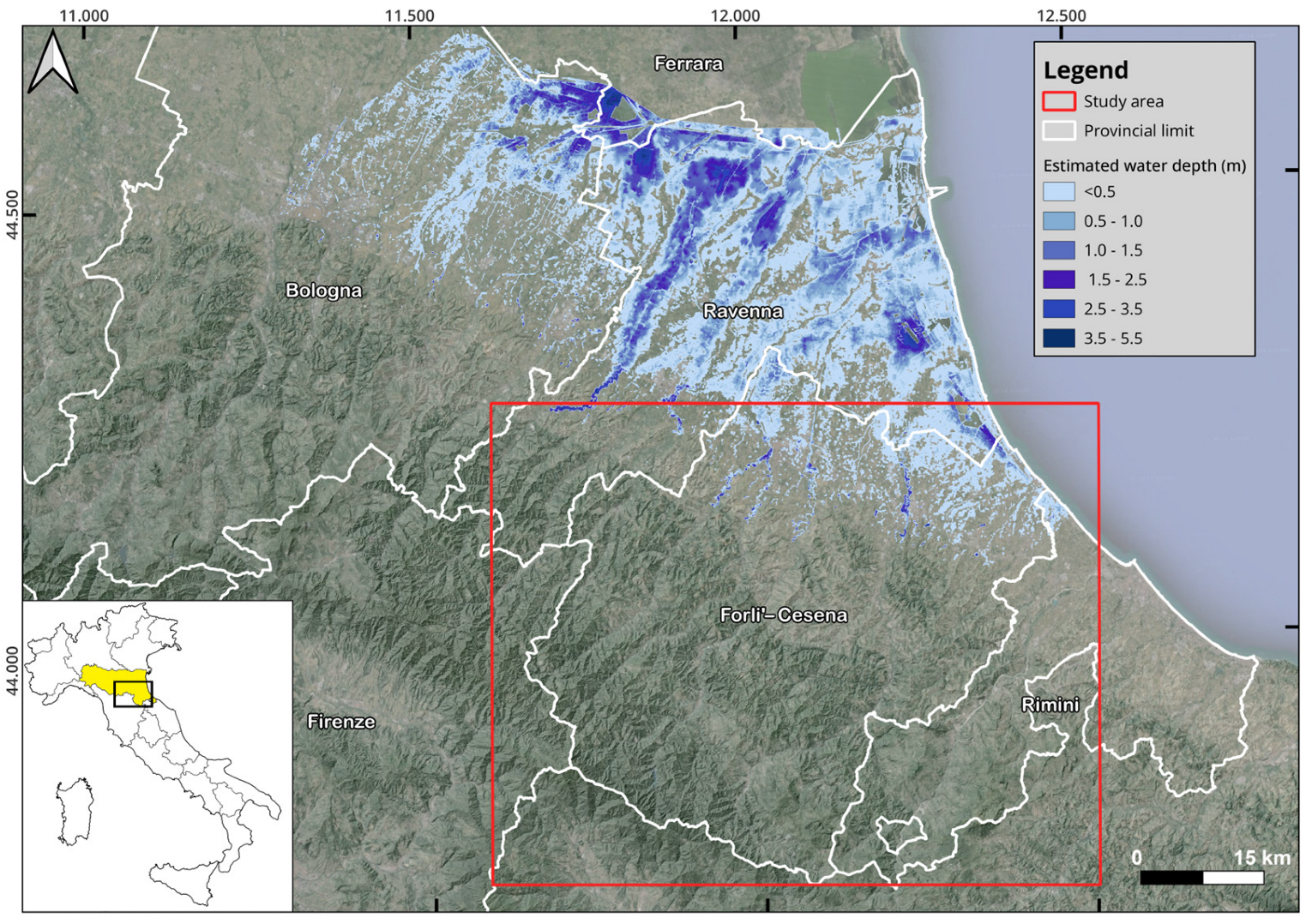
3. The May 2023 Rainstorms and Related Ground Effects

In the Emilia-Romagna region, two major events occurred on 1–3 May and on 15–17 May. According to the information collected by different organizations [35,36], during the first event, persistent and continuous rainfall caused the exceeding of soil saturation capacity in a short time [37]. This event, which occurred after an extremely dry period, was characterized by very high rainfall peaks, up to 280 mm in 24 h. Rainfall was concentrated on the hills and foothills in the central-eastern area of the study area and caused a first flood on 2–3 May. The second rainfall event was equally intense (maximum rainfall amount: 260.8 mm in 48 h) and involved approximately the same area. It caused the overflow of 21 rivers, with a peak in Ravenna province (Figure 2). About 1250 km2 were flooded during the second event, with out-of-channel water depths up to 5.5 m. The damage recorded both in the uphill and foothill river stretches was enhanced by the high soil saturation resulting from preceding floods, which caused more rapid and intense run-off, and the strong onshore-directed winds that provoked higher local sea levels along the coast, thus limiting the river discharge [38]. In this respect, on May 16th a coastal storm (“Minerva”), with prevailing winds stretching from the east, generated waves higher than 3 m. The storm lasted 35.5 h, reaching the highest rainfall levels recorded since 2007. The rainfall accumulated over the period 1–17 May recorded by the rain gauges of the regional network was on average 300–400 mm, i.e., 7–8 times the average May rainfall in the region [37]. This amount is also the historical maximum for at least 65% of rainfall stations located in the central-eastern part of Emilia-Romagna. In the hilly sectors of the Ravenna, Forlì-Cesena, and Rimini provinces (Figure 2), the heavy rainfall also triggered countless landslides. The slope failures were mainly slides and slumps, most of which evolved into flows (Figure 3). The first events were observed shortly after the early May rainstorm, in particular around the cities of Ravenna, Forlì-Cesena, and Bologna (https://www.efas.eu/en/news/flood-event-emilia-romagna-italy-may-2023, accessed on 8 February 2025). The second heavy rainstorm (15–17 May) triggered hundreds of landslides, which caused extensive road closures that isolated villages and rural areas (https://reliefweb.int/report/italy/italy-flood-2023-dref-operation-mdrit004, accessed on 8 February 2025) and damaged buildings. The Copernicus Emergency Management Service [39] identified 360 landslides in 57 municipalities, representative of landslide types and damage situations. They are only a small part of those estimated by the authors of [40] (i.e., 45,000, both first-time and reactivated landslides). Despite most of these landslides being less than 1000 m3 in volume (Figure 4), they still caused substantial damage.

4. Materials and Methods

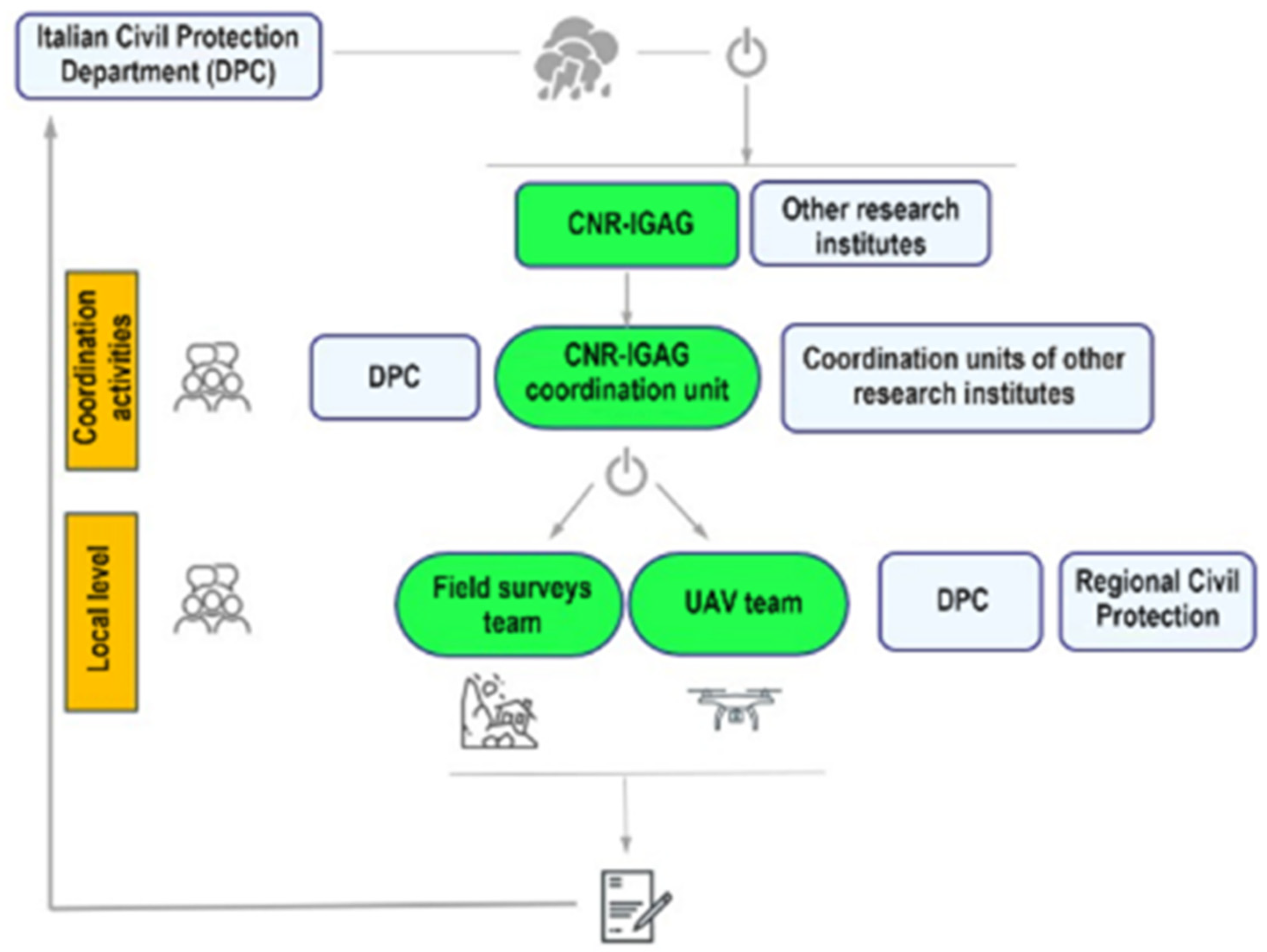
4.1. Coordination of Post-Event Activities

The preliminary scenario which emerged from the inspections following the 2023 rainfall events led the DPC to request technical and scientific assistance from its Centers of Expertise in landslide hazard, especially for assessing residual hazard conditions in specific areas selected by the regional administration. To perform the requested activities, CNR-IGAG applied procedures and workflows (Figure 5) already used by the institute in previous emergencies for natural disasters (e.g., earthquakes).
Activities were coordinated at two levels. At the first level, the coordination units of each institute and the DPC staff established how to execute field and UAV photogrammetric surveys on the areas affected by landslides, how to transfer the results to DPC and Emilia-Romagna region administration, and the timings for the requested activities. At the second level, daily local meetings were held among each survey team, the local staff of DPC, and the Civil Protection Agency of the Emilia-Romagna region. For each site, results of field surveys were reported on a synthetic, standardized form based on the experience gained from previous emergencies. The form includes the exact location, dimensions, and type of landslide/s, as well as the involved materials. For each UAV survey, the researchers prepared a report specifying the location and extent of the study area, and employed instrumentation, survey procedure, and products derived from UAV images, including orthomosaics, point clouds, and high-resolution digital elevation models (DEMs).

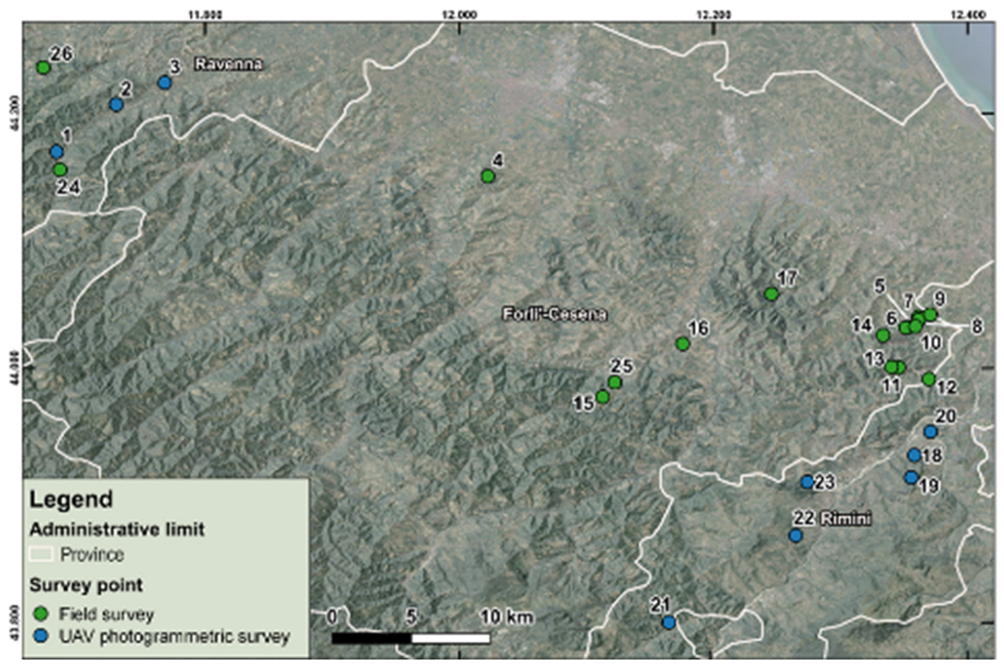
4.2. On-Site Activities

In June 2023, sixteen CNR-IGAG researchers conducted on-site surveys in 26 areas located in the Forlì-Cesena (FC), Ravenna (RA), and Rimini (RN) provinces (Figure 6). Activities consisted of in-field inspections, often supported by non-georeferenced UAV surveys to collect elements on slope geomorphology and landslide geometry in areas with scarce or no access, and UAV photogrammetric surveys on landslide areas.

4.2.1. UAV Photogrammetric Acquisitions

We employed state-of-the-art technology and techniques to conduct UAV photogrammetry and produce accurate DEMs for the different areas. The surveys were conducted on the left flank of the Lamone River valley in the Ravenna province (sites 1–3: Sant’Eufemia-Purocielo, Brisighella-Fognano, and Brisighella, respectively) and at different locations in the Rimini province (sites 18–23).
At sites 1–3, we used a small size commercial drone (DJI Mavic 2 Pro), equipped with a 1″ CMOS sensor with 20 Mpx of effective resolution. On the drone, an additional GNSS (Global Navigation Satellite System) antenna with a card to record GPS and GLONASS (GLobal Orbiting NAvigation Satellite System) constellation signals was installed. All GNSS signals, which were post-processed through the PPK (post processing kinematic) technique, were then synchronized with camera shots providing centimetre accuracy, in both altimetric and planimetric. To achieve the most accurate drone positioning, a multi-constellation, multi-frequency Stonex S900A® GNSS base station was installed in static mode at each survey site. The short baseline (a few hundred metres) between the GNSS rover and base receiver allowed highly accurate UAV positioning. All GNSS raw data from the base station were processed against the permanent GNSS SmartNet network framed in RDN (Rete Dinamica Nazionale) 2008, with respect to the closest permanent station. The Drone Link software version 4.7.0 was used for flight planning, ensuring a constant flight altitude above ground level (a.g.l). This resulted in approximately equal pixel spatial resolution across all frames recorded in the survey. In addition, to ensure precise control and ground reference points, GNSS/RTK (real time kinematic) surveys were conducted along the study areas using group control points (GCPs) in a homogeneous mode from the source areas to the foot of landslide deposits.
At Sant’Eufemia-Purocielo, a cross-flight was performed with 85% coverage in front overlap and 80% in side overlap, maintaining aircraft altitude at about 90 m a.g.l (Figure 7). This approach resulted in a ground resolution (ground sampling distance, GSD) of 2 cm/px, covering a total area of 40,000 m2. At the Brisighella-Fognano and Brisighella sites, we used a UAV survey flight altitude of 80 m with 85% and 70% coverage of the frames (total area coverage of 90,000 m2 and GSD of 1.8 cm/px) and an altitude of 80 m with 80% and 70% coverage of the frames (total area coverage of 70,000 m2 and GSD 1.8 cm/px), respectively. In both surveys, we used a variable flight altitude depending on the elevation of the terrain.
The UAV surveys at the other 6 locations (sites 18–23) were carried out using a DJI Matrice 600 Pro drone, equipped with GeoSun GS-100C LiDAR (light detection and ranging) technology. The absolute position and orientation of the drone were determined through the on-board GNSS sensors, coupled with a ground-operated EMLID Reach RS2® GNSS antenna which was located within a few hundred metres of the UAV-surveyed area. The recorded signals were post-processed with the PPK GeoSun Shuttle software. The LiDAR system integrates a Livox laser scanner which allows for an accuracy of the measured points greater than 5 cm. The system also acquired photographs during flight, which were used to colour the data in the point clouds and generate orthophotos of the surveyed areas. The surveys covered an area ranging from 50,000 m2 (Site 20: San Leo-Monte di Pietracuta) to 500,000 m2 (Site 23: Novafeltria-Le Ville), depending on the extent of the landslide phenomena.

4.2.2. Field Surveys

Alongside UAV acquisitions at specific locations, field surveys were also performed in June 2023 to acquire detailed information for a better understanding of the landslide phenomena, especially in the case of very small-size events (20–30 m3). During field surveys, we collected data about landslide type and geometry (e.g., length, width, depth where visible, tension cracks, hydraulic conditions), the involved materials, evidence of pre-existing instability phenomena, and damage to man-made structures. We also collected soil samples and interviewed the locals about the time and evolution of the events (Figure 8a). In some cases, the field inspections were assisted directly on site by UAV surveys. Acquired photographs were also utilized to interpret field data, especially where the access was dramatically limited by impervious morphology and safety conditions (Figure 8b). All information was synthetized for preliminarily assessing the landslide residual hazard. For this reason, specific focus was given to the identification of potential natural/anthropic elements that, beyond rainfall, may have contributed to landslide initiation (e.g., slope morphology, road cuts). In the light of the inferred scenario, criteria to preliminarily mitigate hazards were also provided.

5. Results

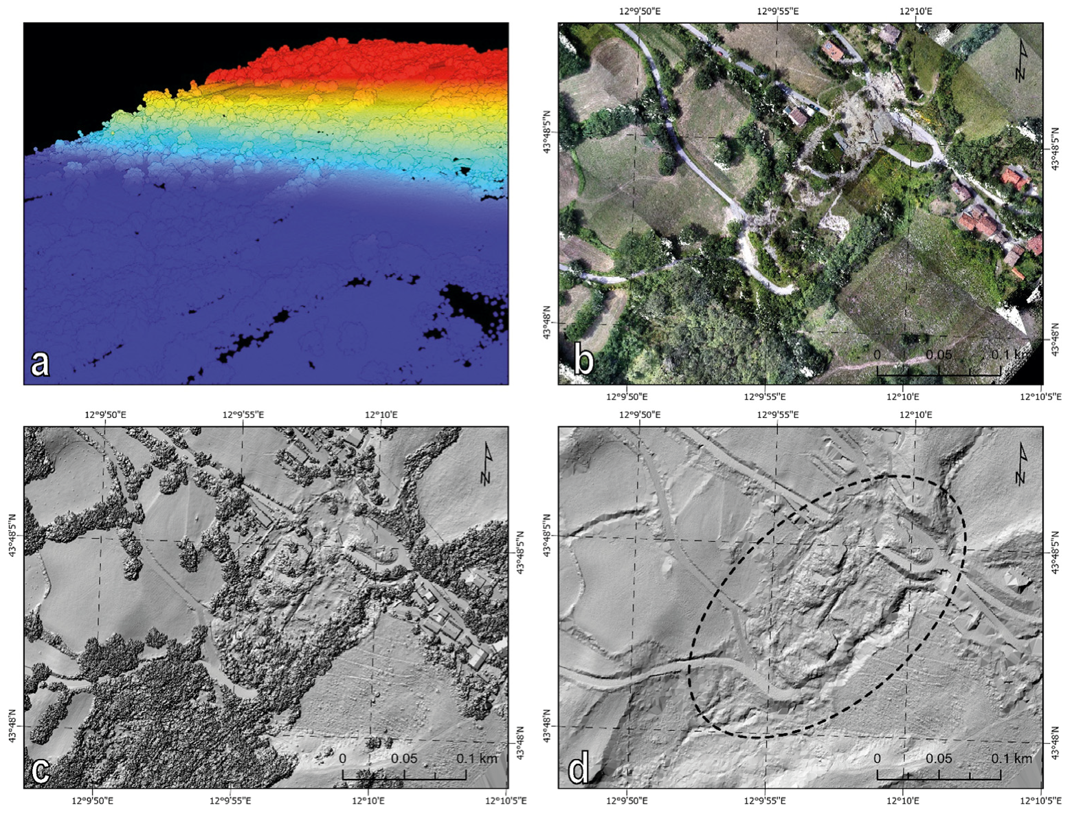
5.1. UAV-Derived Products

At the Sant’Eufemia-Purocielo, Brisighella-Fognano, and Brisighella sites (sites 1–3), we reconstructed the 3D point clouds and the derived products through the structure from motion (SFM) technique [41,42,43] using PIX4D® software. To improve model accuracy, we first aligned and georeferenced the images using the GCP position of the drone at the time of acquisition of each image. The overall root mean square error (RMSE) for the GCP position varies from 0.5 cm to 1.5 cm in longitude and latitude (x-y plane) and from 1 cm to 3 cm in altitude. Subsequently, the georeferenced dense point clouds were generated and refined through automatic filtering algorithms and manual adjustments to eliminate noises. Point cloud data were interpolated to extract DEMs with resolution ranging from 1 cm/px to 2 cm/px. Additionally, a 2.5D mesh was created through point cloud interpolation, enabling the construction of a textured 3D model. We also generated an orthomosaic of each area by merging the orthorectified images. Map products were visualized through Global Mapper software, which was also utilized to define the actual ground with respect to vegetation and infrastructure and, hence, improve the classification of point clouds. All outputs were georeferenced in the WGS84/UTM coordinate system zone 32N (EPSG: 32632). To obtain the official, national orthometric elevation, we converted the collected GNSS and GCPs positioning data from ellipsoid elevation to orthometric elevation using the ITALGEO2005 model.
Point clouds of locations in Rimini province (sites 18–23) were generated with the GeoSun gAirHawk® processing software. This software generates one point cloud for each straight flight line (strip). Each strip, which has a 30 m overlap with the adjacent one, may contain some systematic alignment errors due to a minor mismatch between the IMU (initial measurement unit) and LiDAR sensor and/or small errors in the IMU/GNSS data. This issue required a 3D strip calibration through a rigid-body transformation function centred on the UAV flight path for each data strip. After calibration, the point clouds were automatically classified to identify ground points and non-ground points (e.g., vegetation, buildings, etc.) through a slope-based morphological filter in ArcGIS Pro. The last step was the calculation of DTMs (digital terrain models) interpolating ground points, DSMs (digital surface models) interpolating the highest points in each location, and orthophotographs extracted from the colourized point clouds. All these products have a 20 cm pixel size. Outputs were again georeferenced in the WGS84/UTM coordinate system zone 33N (EPSG: 32633), while the vertical reference system is the EGM2008 geoid with a resolution of 1x1 arc minutes (https://epsg.io/1027-datum, accessed on 8 February 2025).
The UAV-derived products allowed a clear identification of the morphological features of the landslides, both in vegetated areas, as in site 21 (Casteldelci) (Figure 9), and in very steep areas, as in site 1 (Sant’Eufemia-Purocielo) (Figure 10). At the latter site, we identified two roto-translational landslides that occurred during the first (1–3 May) rainfall event on the left side of Lamone River, formed by a steep scarp carved into the turbidite rock mass (“UMma” unit). The larger landslide (landslide A: ~50,000 m3) dammed the watercourse, which then overflowed the right bank, flooding an artificial basin and some nearby houses. We identified numerous detachment areas over the landslide scar, with vertical displacements ranging from few decimetres to several metres. Conversely, the smaller landslide (landslide B: ~1500 m3) moved approximately as a quasi-rigid body, with approximately 6 m of vertical displacement measured at the detachment zone. The landslides involved both the debris accumulated along the lower third of the slope and the shallow softened/loosened portion of the bedrock in the upper half. The accumulation of the landslide debris sharply changed the watercourse geometry, with an advancement of the left bank and a significant retreat of the right bank of about 50 m (Figure 11).
At the Brisighella-Fognano and Brisighella sites (site 2 and 3 in Figure 6), the slopes are characterized by a progressively higher gradient proceeding upwards (up to 35−50°). From the half upper slope, dozens of shallow (1–3 m) translational slides and a few, larger roto-translational slides detached and evolved into earthflows or debris flows, depending on the involved material (highly weathered/softened portion of the bedrock or debris), grain size (amount of fine fraction), and local slope geometry. Such events mainly occurred in cultivated areas (Figure 3a and Figure 12). Due to their run-out (several tens of metres), these landslides affected several man-made structures located at the slope foot, such as stretches of railway, roads, and buildings.

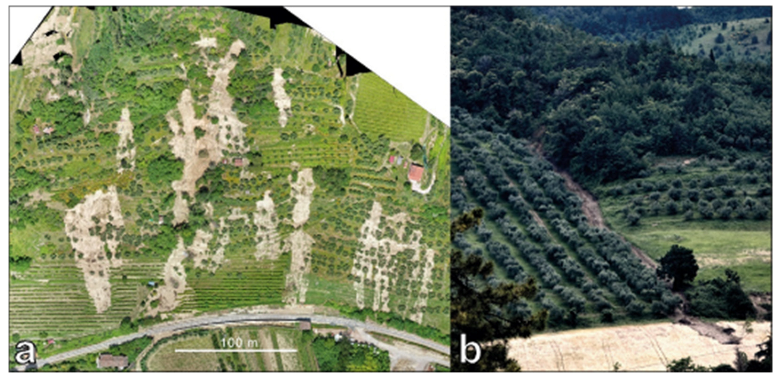
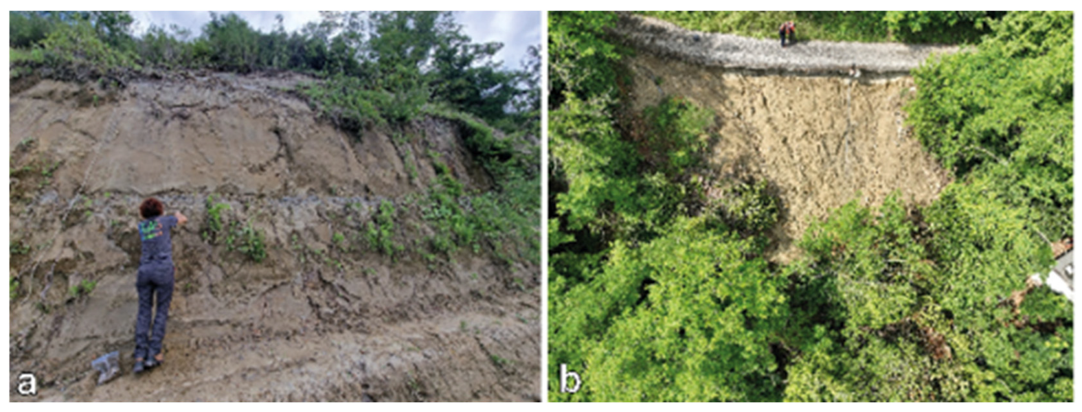
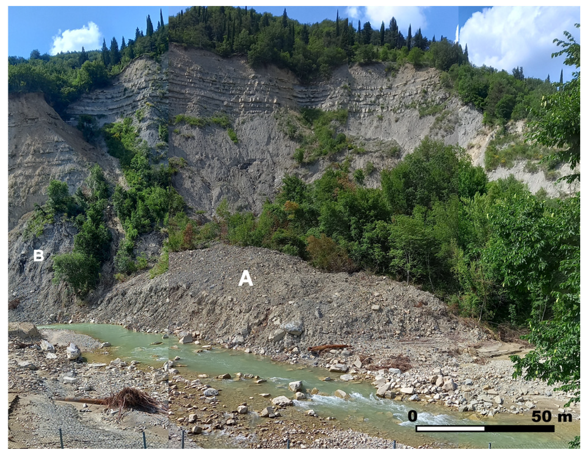
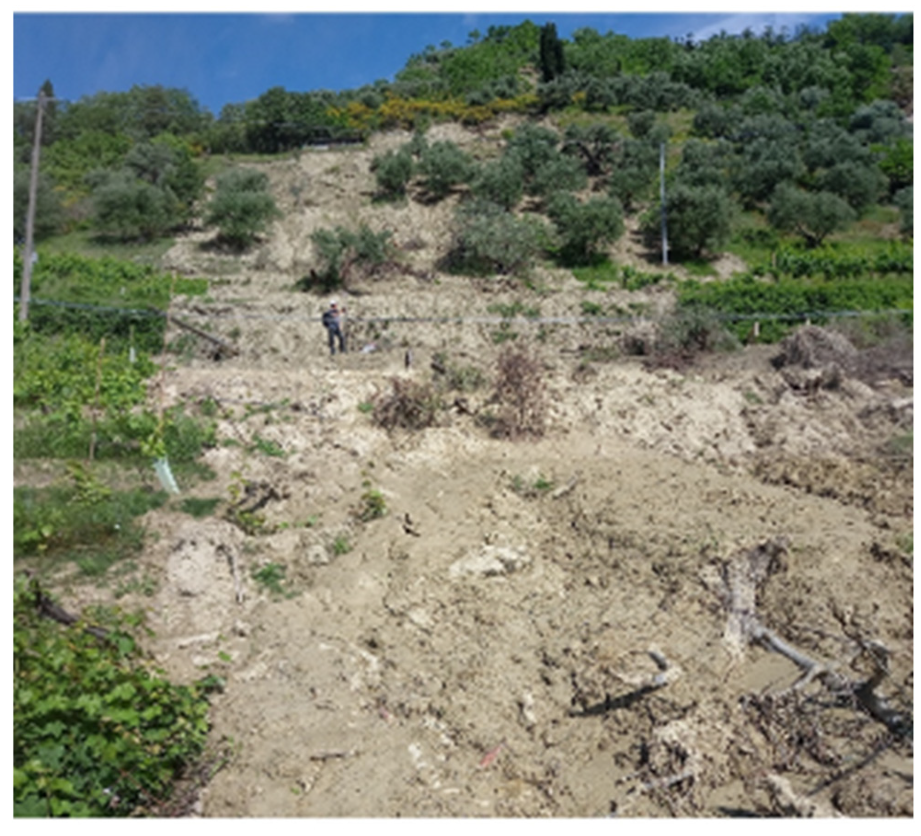
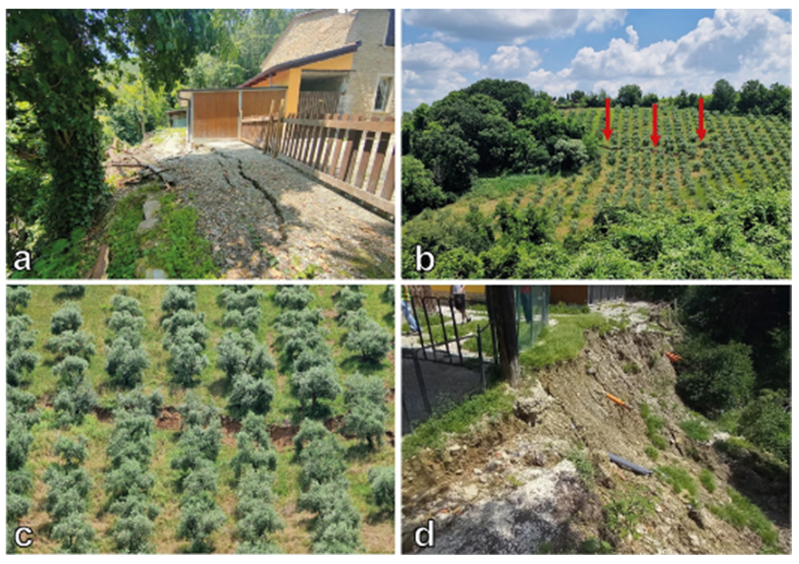
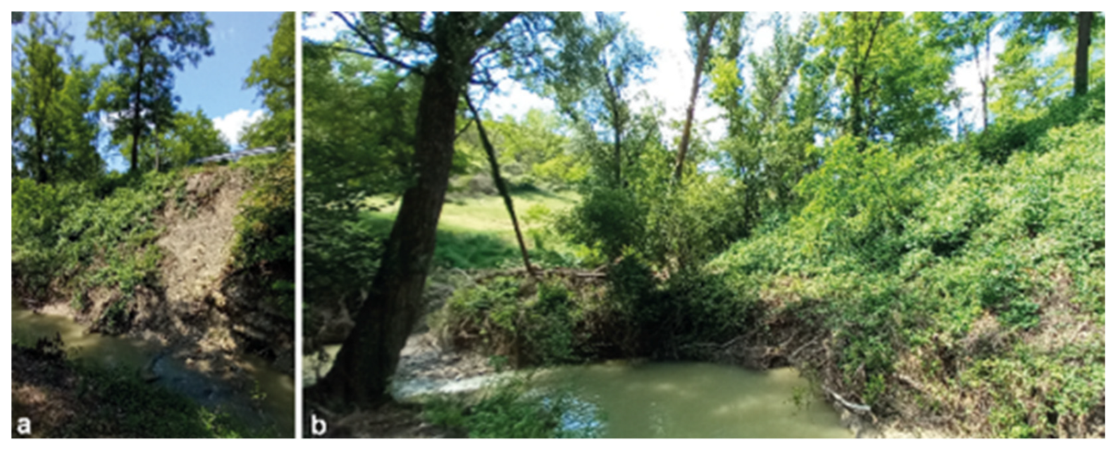
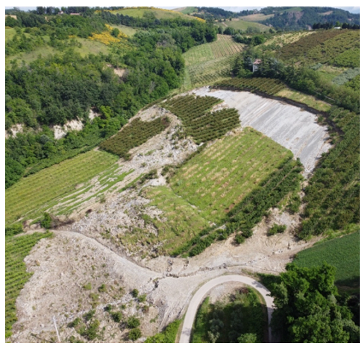
5.2. Main Features of Observed Phenomena During Field Surveys

Most of the observed landslides were from 1 to 2 m thick and only in a few cases did the thickness reach 4–5 m. Their width ranged from five metres (Figure 13a) to several tens of metres (Figure 13b). The displaced material generally consists of colluvial and residual covers, the latter being the result of weathering, softening, and partial disruption of the bedrock. Grain size composition depends on the type of bedrock: plio-pleistocenic stiff clays (Figure 13c) and alternations of sandstone and mudstone layers forming turbiditic deposits (Figure 13d). We also observed that landslides often evolved into flows. For instance, in the S. Cassiano (site 24) we observed that the residual covers located in the upper and less steep part of the slope were mobilized as slumps/slides that successively evolved into debris flows travelling along narrow and deep incisions of the bedrock (Figure 13e). It is worth noting that only the acquisition of optical images through UAVs allowed us to reconstruct the entire process and individuate the source areas that otherwise would have been directly inaccessible due to the steepness and height of the lower part of the slope.
The initial kinematics can be either translational or roto-translational with a more or less pronounced rotational component; however, complex landslides were also observed. In many cases, behind the source areas we observed minor scarps and fractures with varying persistency (1 m to 20 m) and depth (0.5 m to 1.5 m) (Figure 14a), which led us to consider potential retrogression processes. In particular, landslides in clayey slopes tended to form long tension cracks, sometimes evolving into small landslide scarps (Figure 14b,c).
We also noticed that the May 2023 landslides often occurred near to pre-existing landslides or remobilized them, as testified by the landslide inventory map of the Emilia-Romagna region (https://ambiente.regione.emilia-romagna.it/it/geologia/geologia/dissesto-idrogeologico/la-carta-inventario-delle-frane, accessed on 8 February 2025). Further evidence of pre-existing instability phenomena was the damage to roads, buildings, and retaining structures, whose aspect predated the May events.
In many cases, the location of both first-time and reactivated landslides was influenced by human activities. In this sense, we observed that landslides mainly occurred along roadsides, where triggering was favoured by the excessive gradient of the slope, both uphill and downhill, often coupled with the lack of, or poor maintenance of, retaining structures. In this respect, it is important to specify that the observed downhill scarps are mostly natural slopes, and not fill slopes, which instead usually tend to fail due to poor compaction and/or overloading of the slope itself [44]. Furthermore, we frequently noticed that rainwater collected on the ground surface and from roof gutters was directly discharged onto the slope (Figure 14d). This water amount strongly enhanced surface runoff and, hence, soil erosion.
Landslides also involved riverbanks (Figure 15a), leading to the partial or total obstruction of the watercourse and, in several cases, to localized flooding. In the same areas, we also found morphological evidence (Figure 15b) of landslide recurrency even in recent times.
Although less frequent, several planar rockslides along bedding joints also occurred during May 2023. Slides mobilized single or multiple rock layers of regularly bedded slopes carved in the UMma turbiditic formation. Sliding involved 1 to 8 m-thick packs of layers with a varying sandstone/pelite (mudstone or clay) ratio (i.e., from 0.2 to over 3).
In the eastern part of the study area, slides were observed in the sandstone-rich member of the UMma formation. The failure process displaced slabs, dipping at 22°, and was formed by single rock layers less than 1 m-thick with an area of approximately 100 m2 and a daylighted toe (Campiano, site 25).
Larger planar rockslides occurred in the western part of the region, where a pelite-rich member of the UMma formation mostly outcrops. The area shows clear signs of past landslide events that occurred even a few months before the rainstorms. They involved mudstone, clay, and sandstone layers up to 8 m thick. The largest event in the Villa San Giovanni (site 26) involved a planar slab, dipping at 15–16°, formed by a 2 m-thick pack of layers without a daylighted toe, with an area of about 30,000 m2 (Figure 16). Regarding the failure process, from the observation of the disrupted fold at the toe, we inferred that sliding was preceded by a flexural buckling of the slab. Sliding occurs in the correspondence of sharp lithological variations within the turbiditic rock mass, i.e., between mudstone and sandstone layers, or along clay interbeds between sandstone layers in the sandstone-rich portions. In this respect, the shear strength characteristics of such layers were discussed by [45], which reported data of in situ direct shear tests conducted on bedding joints of the UMma formation close to the surveyed landslides. According to these results, the layers are characterized by a friction angle of 33–34° and negligible cohesion, unless they are slickensided. In the latter case, the friction angle drops to 12.5–15°; however, slickensided surfaces were not observed in the study areas.

6. Discussion

From the on-site surveys, we noticed a clear predisposition of the slopes to rainstorm-induced landslides, especially of the shallow type. Although anthropogenic factors (e.g., gutter waters discharged directly onto the slope, inadequate road cut slopes, and downhill scarps) may have contributed to initiating several landslides, the very large number and the ubiquitous diffusion of the May 2023 landslides mainly depends on the geological–geomorphological and geotechnical conditions of the slopes in connection with rainfall history, not least due to their relative homogeneity over such a large area (as pointed out by detailed UAV acquisitions). The exceptionality of the meteorological event can be estimated through a statistical analysis of the historical rainfall data. We analyzed the maximum values assumed by the rainfall accumulated over different daily and hourly periods through the generalized extreme value (GEV) distribution [46], which is widely used to model extreme climatic events [47]. To derive the parameters for the GEV cumulative distribution, we utilized the probability weighted moment (PWM) method [48], starting from the maximum annual values of the rainfall accumulated over 2, 5, 10, 20, 30, 60, 90, 120, and 180 days (Pcum,d2 …. Pcum,d180) and 1, 3, 6, 12, 24, and 48 h (Pcum,h1 …. Pcum,h48). Subsequently, we inverted the probability function to obtain the values of rainfall accumulated over different times for various return periods (RPs). We used two climatic datasets (i.e., daily and hourly scale) made available by the Regional Agency for Prevention, Environment and Energy of Emilia-Romagna region (ARPAE). They result from the spatial interpolation on a regular grid of rainfall values recorded by historical meteorological stations [49]. In particular, each grid cell reports daily data from 1961 (https://dati.arpae.it/dataset/erg5-eraclito, accessed on 8 February 2025) and hourly data from 1991 (https://dati.arpae.it/dataset/erg5-interpolazione-su-griglia-di-dati-meteo, accessed on 8 February 2025). If we focus our analysis on the Borghi municipality, where most of the observed landslides are located (i.e., sites 5–14), we notice that the most severe rainfall event of May 2023 was the second one (16–17 May) (Figure 17a). This event was rather exceptional, having a RP of 77 years for Pcum,d2 (Table 1). A high value (71 years) was also found for Pcum,d20 as it includes the early May event (Figure 17a). Conversely, the rainfall accumulated over longer periods has a considerably lower RP because the winter and early spring were particularly dry. The analyzed data refer to the Santa Paola station, which is approximately at the same elevation as the areas affected by the landslides, 5 km away. Conversely, the analysis of data from the Ponte Verucchio station, located at a similar distance but at a considerably lower elevation, yields significantly lower RPs (Table 1). This suggests that the 16–17 May rainfall event, at least in the Borghi area, was characterized by sharp local differences, partially due to orographic effects. The analysis of the hourly rainfall data, again from Santa Paola station, indicates that the exceptional rainfall accumulated over more than 12 h (Table 2). In turn, shallow landslides in Borghi would have been triggered by daily scale, medium-duration rainfall, unlike other cases of widespread landslides recently observed in Italy [50,51]. The occurrence in 1939 of a similar event in the area (see Section 2.2) indicates that the RPs are reasonable. In this respect, the rainfall during the 1939 rainstorm was even higher due to a longer duration: 269.2 mm from 29 May to 2 June 1939 versus 214.8 mm from 16 May to 17 May 2023.
The analysis of rainfall data from the westernmost part of the study area (i.e., the Sant’Eufemia-Purocielo site) provides different results. The two rainfall events were significantly more severe than in the Borghi area and exhibited a substantially similar rainfall intensity (Figure 17b). The RPs of the Pcum,d2 estimated with the rainfall data of the S. Cassiano Lamone station (2 km far from the slide) are very high for both May 2023 events, and definitely exceed those obtained at Borghi (Table 3). These values are consistent with the report from [35], which suggests a RP for the 1–3 May event greater than 100 years for many rainfall stations over the region. If we also analyze the cumulative effect of the two May 2023 events (i.e., with an accumulation time longer than 10 days for the 16–17 May event), the RPs are even higher, thus substantiating the exceptionality of two such severe events within a few days. It is important to stress that the occurrence of similar events is globally increasing likely due to climate change [52,53], and a similar trend was also observed in northern Italy [54,55]. For instance, while the authors were completing the present work, on the 17–18 September 2024 intense rainfall again affected the eastern Emilia-Romagna region, causing extensive flooding and many landslide episodes (https://rapidmapping.emergency.copernicus.eu/EMSR762/reporting, accessed on 8 February 2025). In this case, the S. Cassiano Lamone station recorded a total rainfall amount of approximately 350 mm, with two consecutive maximum 1 h rainfall peaks of some 45 mm. These values are even greater than those recorded during the May 2023 event, suggesting that similar events are to be considered less and less exceptional in a climate change scenario.
It was also observed that the recorded landslides often occurred at or close to pre-existing landslides areas. This field evidence is substantiated by the fact that almost half of the 360 landslides recorded by [39] (see Section 3) partially or entirely fall within active/dormant landslide areas, according to the landslide inventory map of the Emilia-Romagna region (https://ambiente.regione.emilia-romagna.it/it/geologia/geologia/dissesto-idrogeologico/la-carta-inventario-delle-frane, accessed on 8 February 2025). A total of 15 out of the 26 observed landslides occurred within or in the proximity of (distance < 50 m) already-known landslides. Slope instabilities are so widespread that we found countless damage to and the interruption of roads connecting towns and villages. Nevertheless, such evidence of instability has not discouraged the construction of anthropogenic structures over the years. This possibly suggests that landslide risk was scarcely perceived at both individual and public levels. As regards to the road network, we observed that road cuts were excessively steep, which implies an underestimation of the velocity of the weathering/slaking processes of weak sandstones and argillaceous rocks. These processes lead to the formation of relatively thick, residual covers over steep slopes in a short time (a few decades).
In the light of both the above-described general framework and the widespread signs of potential reactivations observed in the landslide areas (e.g., minor scarps, opened cracks, etc.), it can be affirmed that the surveyed areas still exhibit relatively high residual geomorphological hazard conditions.

7. Conclusions

The preliminary analysis of field and UAV-derived data collected for emergency purposes on the landslides triggered by the May 2023 rainstorms in the eastern part of Emilia-Romagna region (northern Italy), provided the following findings:
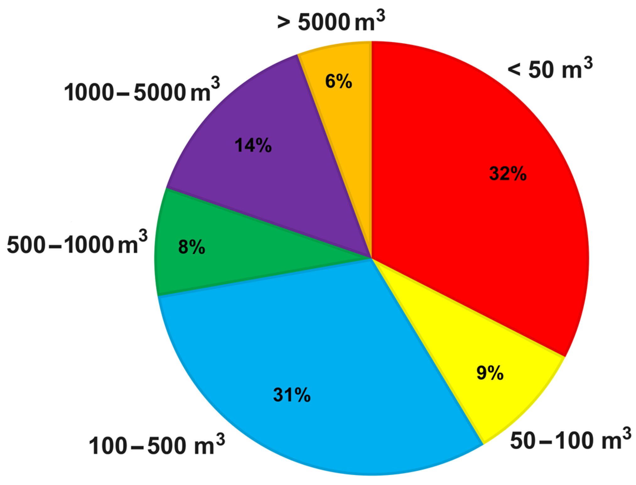
  • Most landslides were shallow and characterized by different kinematics (i.e., rotational and translational failure in the colluvial and residual covers) and often evolved into flows.
  • Despite the relatively small volume, the ubiquitous occurrence of such events resulted in uncountable road interruptions, threats to buildings and other structures, and the damming of watercourses leading to further flooding in the innermost valley areas.
  • Anthropogenic activities may have influenced triggering mechanisms through the increase in slope gradients, water infiltration, and runoff-generated erosion. In this respect, the absence or poor maintenance of retaining structures and drainage devices (both of surface and underground water) was frequently observed.
  • Regardless of potential anthropic influence, the May 2023 landslides can be explained by the high sensitivity of the geological–geotechnical slope settings to the sharp hydraulic changes induced by extreme rainfall intensity. The statistical analysis of historical rainfall records highlights the exceptionality of the two single rainstorms of the 1–3 May and 15–17 May, which increases from east (RPs > 70 years) to west (RPs > 500 years). However, what is more important is the occurrence of two such severe events in the same area in the span of a few days.
  • Beyond the exceptionality of the May 2023 rainfall, all the observed landslides occurred in an area characterized by high landslide susceptibility, as testified by the geological and geomorphological setting of the area itself and by the fact that many landslides were located at or close to pre-existing, mapped landslides.
The general overview of the occurred events is valuable not only to take emergency decisions but also for addressing hazard and risk assessment, as well as the post-event management (e.g., restoration of serviceability conditions, reconstruction of buildings and infrastructure). The location of many landslides along old construction roads (usually without mitigation measures) and close to old buildings testifies both a limited perception of the landslide hazard at the time of construction and practical evidence of the exceptionality of May 2023. Such an exceptionality holds true when we analyze RPs of rainfall events over a time span extending far back to the 20th century. However, if we consider the ongoing climate change scenario, and hence a timeline closer to the present, we should reappraise the exceptionality of these events. A major consequence is that the hazard distribution in the region and, hence, the location and design of man-made structures and mitigation measures, should be reconsidered in relation to the increasing frequence of extreme rainfall events.
Finally, it is important to stress that such results were obtained during an emergency phase, when health and safety of the population are the priority. Surveys were dramatically complicated by extensive flooding and countless landslides that interrupted many roads connecting villages. In this sense, despite the typically small size of landslides, their extremely high number coupled with the dispersed urbanization of the area resulted in significant damage. Nevertheless, the performed surveys and the consequent data assessment allowed us to outline the main, peculiar characteristics of the May 2023 landslides. Field surveys provided detailed observations of accessible landslide areas, valuable for understanding specific aspects related, for instance, to the triggering process (e.g., the role of drainage devices), type of involved materials, and depth of the substratum. The use of UAV surveys has proven to be highly effective for the reconnaissance of landslides, especially where direct access to the whole area affected by failure and propagation was limited, or even not possible. In particular, UAV images enabled an overall view of the observed landslide, identification of dangerous situations not directly inspectable (e.g., stability conditions of structures/infrastructures at the edge of steep, high slopes), identification of potential additional phenomena in surrounding areas not directly visible from the ground, and inspection of areas beyond obstructed road stretches. Finally, the high resolution of the acquired images allowed identification of peculiar morphological features which, in turn, provided useful information about the triggering mechanisms and potential, future evolution of the instability process.

Author Contributions

L.S.: conceptualization, field investigation, methodology, data curation, writing—original draft. A.B.: field investigation, data curation, writing—review and editing. G.M.C.: field investigation, data curation, writing—review and editing. A.C.: writing—review and editing. S.C.: field investigation, data curation, writing—review and editing. C.D.S.: field investigation, data curation, writing—review and editing. I.G.: field investigation, data curation, writing—review and editing. M.M.: writing—review and editing. G.N.: field investigation, data curation, writing—review and editing. E.P.: field investigation, data curation, writing—review and editing. F.P.: writing—review and editing. M.S.: field investigation, data curation, writing—review and editing. F.S.: field investigation, data curation, writing—review and editing. C.V.: writing—review and editing. P.T.: conceptualization, field investigation, data curation, writing—review and editing. All authors have read and agreed to the published version of the manuscript.

Funding

This research was funded by the Italian Department for Civil Protection of the Presidency of Council of Ministers within the “Accordo ai sensi dell’art. 15 legge 7 agosto 1990, n. 241 tra la Presidenza del Consiglio dei Ministri il Dipartimento della Protezione Civile e il Consiglio Nazionale delle Ricerche Istituto di Geologia Ambientale e Geoingegneria per il supporto al Dipartimento della Protezione Civile per la programmazione degli interventi in materia di riduzione del rischio sismico ai fini di protezione civile” (CUP: B53C22009330001).

Data Availability Statement

Orthophotos of the areas surveyed during the emergency are available as WMS layer at the following link: https://geoportale.regione.emilia-romagna.it/ (last access: 8 February 2025). Other data are available on request from the corresponding author, provided the approval of the Italian Department for Civil Protection of the Presidency of Council of Ministers.

Acknowledgments

The authors would like to thank the following personnel of the Department of Civil Protection for their support in survey activities: Andrea Duro, Marco Falzacappa, Francesco Leone, Federica Marchetto, Antonio Oriente, Giovanni Valgimigli.

Conflicts of Interest

The authors declare no conflicts of interest.

Abbreviations

The following abbreviations are used in this manuscript:
ARPAERegional Agency for Prevention, Environment and Energy of Emilia-Romagna region
CNR-IGAGResearch Institute of Environmental Geology and Geoengineering of the Italian National Research Council
CNR-IRPIResearch Institute for Geo-Hydrological Protection of the Italian National Research Council
DEMDigital Elevation Model
DPCCivil Protection Department
DSMDigital Surface Model
DTMDigital Terrain Model
GCPGround Control Point
GEVGeneralized Extreme Value
GLONASSGLobal Orbiting NAvigation Satellite System
GNSSGlobal Navigation Satellite System
GSDGround Sampling Distance
IMUInitial Measurement Unit
ISPRAItalian Institute for Environmental Protection and Research
LiDARLight Detection And Ranging
PPKPost Processing Kinematic
PWMProbability Weighted Moment
RDNRete Dinamica Nazionale
RMSERoot Mean Square Error
RPReturn Period
RTKReal Time Kinematic
SFMStructure From Motion
UAVUnmanned Aerial Vehicle

References

  1. Tsuchida, T.; Athapaththu, A.M.R.G.; Hanaoka, T.; Kawaguchi, M. Investigation of Landslide Calamity Due to Torrential Rainfall in Shobara City, Japan. Soils Found. 2015, 55, 1305–1317. [Google Scholar] [CrossRef]
  2. Cascini, L.; Cuomo, S.; Della Sala, M. Spatial and Temporal Occurrence of Rainfall-Induced Shallow Landslides of Flow Type: A Case of Sarno-Quindici, Italy. Geomorphology 2011, 126, 148–158. [Google Scholar] [CrossRef]
  3. Sarikhan, I.Y.; Stanton, K.D.; Contreras, T.A.; Polenz, M.; Powell, J.; Walsh, T.J.; Logan, R.L. Landslide Reconnaissance Following the Storm Event of December 1–3, 2007, in Western Washington; Open File Report 2008-5; Washington Department of Natural Resources, Division of Geology and Earth Resources: Olympia, WA, USA, 2008; p. 22. Available online: https://file.dnr.wa.gov/publications/ger_ofr2008-5_dec2007_landslides.pdf (accessed on 11 March 2025).
  4. Bessette-Kirton, E.K.; Coe, J.A.; Schulz, W.H.; Cerovski-Darriau, C.; Einbund, M.M. Mobility Characteristics of Debris Slides and Flows Triggered by Hurricane Maria in Puerto Rico. Landslides 2020, 17, 2795–2809. [Google Scholar] [CrossRef]
  5. Bucknam, R.C.; Coe, J.A.; Mota Chavarría, M.; Godt, J.W.; Tarr, A.C.; Bradley, L.A.; Rafferty, S.; Hancock, D.; Dart, R.L.; Johnson, M.L. Landslides Triggered by Hurricane Mitch in Guatemala-Inventory and Discussion. USGS Open-File Rep. 2001, 01-443, 38. [Google Scholar] [CrossRef]
  6. Neuendorf, K.K.E.; Mehl, J.P., Jr.; Jackson, J.A. Glossary of Geology, 5th ed.; American Geosciences Institute: Alexandria, VA, USA, 2011; p. 800. ISBN 9780922152896. [Google Scholar]
  7. Ellen, S.D.; Wieczorek, G.F. Landslides, floods, and marine effects of the storm of January 3–5, 1982, in the San Francisco Bay Region, California. USGS Prof. Pap. 1988, 1434, 310. [Google Scholar] [CrossRef]
  8. Larsen, M.C.; Wieczorek, G.F. Geomorphic Effects of Large Debris Flows and Flash Floods, Northern Venezuela, 1999. Z. Fur Geomorphol. Suppl. 2006, 145, 147–175, ISBN 978-3-443-21145-5. [Google Scholar]
  9. Avelar, A.S.; Coelho Netto, A.L.; Lacerda, W.A.; Becker, L.B.; Mendonça, M.B. Mechanisms of the Recent Catastrophic Landslides in the Mountainous Range of Rio de Janeiro, Brazil. In Proceedings of the Second World Landslide Forum, Rome, Italy, 3–7 October 2011. [Google Scholar]
  10. Page, M.J.; Rossler, B.J.; Townsend, D.B.; Carey, J.M.; Ries, W.F. Reconnaissance Report on Landsliding Caused by the 19–20 June 2015 Rainstorm in the Taranaki-Wanganui-Manawatu Region. GNS Sci. Rep. 2015, 2015/47, 50. Available online: https://static.geonet.org.nz/info/reports/landslide/SR_2015-047_FINAL.pdf (accessed on 18 September 2024).
  11. Picarelli, L.; Olivares, L.; Damiano, E.; Darban, R.; Santo, A. The Effects of Extreme Precipitations on Landslide Hazard in the Pyroclastic Deposits of Campania Region: A Review. Landslides 2020, 17, 2343–2358. [Google Scholar] [CrossRef]
  12. Luino, F.; Turconi, L. Translational Rock-Block Slides in a Tertiary Flyschoid Complexes of Southern Piedmont Region (North-West Italy). In Landslides-Investigation and Monitoring; Ray, R., Lazzari, M., Eds.; IntechOpen: London, UK, 2020; pp. 35–64. [Google Scholar] [CrossRef]
  13. Lü, Q.; Wu, J.; Liu, Z.; Liao, Z.; Deng, Z. The Fuyang Shallow Landslides Triggered by an Extreme Rainstorm on 22 July 2023 in Zhejiang, China. Landslides 2024, 21, 2725–2740. [Google Scholar] [CrossRef]
  14. Diwakar, K.C.; Dangi, H.; Naqvi, M.W.; Kadel, S.; Bo Hu, L. Recurring Landslides and Debris Flows near Kalli Village in the Lesser Himalayas of Western Nepal. Geotech. Geol. Eng. 2023, 41, 3151–3168. [Google Scholar] [CrossRef]
  15. Guo, F.; Meng, X.; Qi, T.; Dijkstra, T.; Thorkildsen, J.K.; Yue, D.; Chen, G.; Zhang, Y.; Dou, X.; Shi, P. Rapid Onset Hazards, Fault-Controlled Landslides and Multi-Method Emergency Decision-Making. J. Mt. Sci. 2022, 19, 1357–1369. [Google Scholar] [CrossRef]
  16. Mercuri, M.; Biondino, D.; Ciurleo, M.; Cofone, G.; Conforti, M.; Gullà, G.; Stellato, M.C.; Borrelli, L. The Use of an Unmanned Aerial Vehicle (UAV) for First-Failure Landslide Detection. GeoHazards 2024, 5, 683–699. [Google Scholar] [CrossRef]
  17. Franke, K.W.; Lingwall, B.N.; Zimmaro, P.; Kayen, R.E.; Tommasi, P.; Chiabrando, F.; Santo, A. Phased Reconnaissance Approach to Documenting Landslides Following the 2016 Central Italy Earthquakes. Earthq. Spectra 2018, 34, 1693–1719. [Google Scholar] [CrossRef]
  18. Liang, R.; Dai, K.; Shi, X.; Guo, B.; Dong, X.; Liang, F.; Tomás, R.; Wen, N.; Fan, X. Automated Mapping of Ms 7.0 Jiuzhaigou Earthquake (China) Post-Disaster Landslides Based on High-Resolution UAV Imagery. Remote Sens. 2021, 13, 1330. [Google Scholar] [CrossRef]
  19. Esposito, G.; Petrucci, O. Landslide Hazard and Risk Assessment for Civil Protection Early Response. In Understanding and Reducing Landslide Disaster Risk; Sassa, K., Mikoš, M., Sassa, S., Bobrowsky, P.T., Takara, K., Dang, K., Eds.; ICL Contribution to Landslide Disaster Risk Reduction; Springer International Publishing: Cham, Switzerland, 2021; pp. 513–518. ISBN 978-3-030-60195-9. [Google Scholar]
  20. Schilirò, L.; De Blasio, F.V.; Esposito, C.; Scarascia Mugnozza, G. Reconstruction of a Destructive Debris-flow Event via Numerical Modeling: The Role of Valley Geometry on Flow Dynamics. Earth Surf. Process. Landf. 2015, 40, 1847–1861. [Google Scholar] [CrossRef]
  21. Ricci Lucchi, F. The Oligocene to Recent Foreland Basins of the Northern Apennines. In Foreland Basins; Allen, P.A., Homewood, P., Eds.; Blackwell Scientific Publications: Oxford, UK, 1986; Volume 8, pp. 105–140. [Google Scholar] [CrossRef]
  22. Ori, G.G. Continental Depositional Systems of the Quaternary of the Po Plain (Northern Italy). Sediment. Geol. 1993, 83, 1–14. [Google Scholar] [CrossRef]
  23. Conti, P.; Cornamusini, G.; Carmignani, L. An Outline of the Geology of the Northern Apennines (Italy), with Geological Map at 1:250,000 Scale. IJG 2020, 139, 149–194. [Google Scholar] [CrossRef]
  24. Doglioni, C. A Proposal for the Kinematic Modelling of W-dipping Subductions-Possible Applications to the Tyrrhenian-Apennines System. Terra Nova 1991, 3, 423–434. [Google Scholar] [CrossRef]
  25. Tarquini, S.; Isola, I.; Favalli, M.; Battistini, A.; Dotta, G. TINITALY, a Digital Elevation Model of Italy with a 10 Meters Cell Size (Version 1.1); Istituto Nazionale di Geofisica e Vulcanologia (INGV): Rome, Italy, 2023. [Google Scholar] [CrossRef]
  26. Kottek, M.; Grieser, J.; Beck, C.; Rudolf, B.; Rubel, F. World Map of the Köppen-Geiger Climate Classification Updated. Metz 2006, 15, 259–263. [Google Scholar] [CrossRef]
  27. Nistor, M.M. Spatial Distribution of Climate Indices in the Emilia-Romagna Region. Meteorol. Appl. 2016, 23, 304–313. [Google Scholar] [CrossRef]
  28. Piacentini, D.; Troiani, F.; Daniele, G.; Pizziolo, M. Historical Geospatial Database for Landslide Analysis: The Catalogue of Landslide OCcurrences in the Emilia-Romagna Region (CLOCkER). Landslides 2018, 15, 811–822. [Google Scholar] [CrossRef]
  29. Annali Idrologici 1939 Parte Seconda, Bacini con Foce al Litorale Adriatico dal Reno al Tronto. Ministero dei Lavori Pubblici, Rome, Italy. Available online: https://www.arpae.it/it/temi-ambientali/meteo/report-meteo/annali-idrologici/annali-idrologici-1939/view (accessed on 12 September 2023).
  30. Pizziolo, M.; Bernardi, M.; Daniele, G.; Generali, M.; Piacentini, D. Landslide Occurrences During the High-Intensity Rainfall Event of March–April 2013 in the Emilia-Romagna Region (North Apennines, Italy). In Engineering Geology for Society and Territory-Volume 5; Lollino, G., Manconi, A., Guzzetti, F., Culshaw, M., Bobrowsky, P., Luino, F., Eds.; Springer International Publishing: Cham, Switzerland, 2015; pp. 777–780. [Google Scholar] [CrossRef]
  31. Gatto, M.P.A. Incorporating Rainfall Forecast Data in X-SLIP Platform to Predict the Triggering of Rainfall-Induced Shallow Landslides in Real Time. Geosciences 2023, 13, 215. [Google Scholar] [CrossRef]
  32. Bertolini, G.; Guida, M.; Pizziolo, M. Landslides in Emilia-Romagna Region (Italy): Strategies for Hazard Assessment and Risk Management. Landslides 2005, 2, 302–312. [Google Scholar] [CrossRef]
  33. Rossi, M.; Witt, A.; Guzzetti, F.; Malamud, B.D.; Peruccacci, S. Analysis of Historical Landslide Time Series in the Emilia-Romagna Region, Northern Italy. Earth Surf. Process. Landf. 2010, 35, 1123–1137. [Google Scholar] [CrossRef]
  34. Segoni, S.; Lagomarsino, D.; Fanti, R.; Moretti, S.; Casagli, N. Integration of Rainfall Thresholds and Susceptibility Maps in the Emilia Romagna (Italy) Regional-Scale Landslide Warning System. Landslides 2015, 12, 773–785. [Google Scholar] [CrossRef]
  35. ARPAE-Regional Agency for Prevention, Environment and Energy of Emilia-Romagna region. L’evento Meteo Idrogeologico e Idraulico del 16–18 Maggio 2023. Available online: https://www.arpae.it/it/notizie/analisi-evento-16-18-maggio-2023.pdf (accessed on 10 December 2023).
  36. Copernicus Emergency Management Service. Flood in Emilia-Romagna, Italy. EMSN154 Technical Report. Available online: https://emergency.copernicus.eu/mapping/list-of-components/EMSN154 (accessed on 10 December 2023).
  37. CIMA Research Foundation-International Center for Environmental Monitoring. Italian Flood of May 2023: A Scientific Analysis. Available online: https://www.cimafoundation.org/en/news/the-italian-floods-of-may-2023-a-scientific-analysis/ (accessed on 10 December 2023).
  38. Guy Carpenter. Post Event Report: 2023 Mid-May Emilia-Romagna Flood. Available online: https://www.guycarp.com/insights/2023/06/Italy_Emilia-Romagna_Flood_2023-05.html (accessed on 10 December 2023).
  39. Copernicus Emergency Management Service. Landslide Delineation and Volume Estimation in Emilia-Romagna, Italy. EMSN156 Technical Report. Available online: https://emergency.copernicus.eu/mapping/list-of-components/EMSN156 (accessed on 12 September 2023).
  40. Ferrario, M.F.; Livio, F. Rapid Mapping of Landslides Induced by Heavy Rainfall in the Emilia-Romagna (Italy) Region in May 2023. Remote Sens. 2023, 16, 122. [Google Scholar] [CrossRef]
  41. Westoby, M.J.; Brasington, J.; Glasser, N.F.; Hambrey, M.J.; Reynolds, J.M. ‘Structure-from-Motion’ Photogrammetry: A Low-Cost, Effective Tool for Geoscience Applications. Geomorphology 2012, 179, 300–314. [Google Scholar] [CrossRef]
  42. Tomasello, A.; Bosman, A.; Signa, G.; Rende, S.F.; Andolina, C.; Cilluffo, G.; Cassetti, F.P.; Mazzola, A.; Calvo, S.; Randazzo, G.; et al. 3D-Reconstruction of a Giant Posidonia Oceanica Beach Wrack (Banquette): Sizing Biomass, Carbon and Nutrient Stocks by Combining Field Data With High-Resolution UAV Photogrammetry. Front. Mar. Sci. 2022, 9, 903138. [Google Scholar] [CrossRef]
  43. Anzidei, M.; Trippanera, D.; Bosman, A.; Martin, F.F.; Doumaz, F.; Vecchio, A.; Serpelloni, E.; Alberti, T.; Rende, S.F.; Greco, M. Relative Sea-Level Rise Projections and Flooding Scenarios for 2150 CE for the Island of Ustica (Southern Tyrrhenian Sea, Italy). J. Mar. Sci. Eng. 2023, 11, 2013. [Google Scholar] [CrossRef]
  44. Sidle, R.C.; Ghestem, M.; Stokes, A. Epic Landslide Erosion from Mountain Roads in Yunnan, China—Challenges for Sustainable Development. Nat. Hazards Earth Syst. Sci. 2014, 14, 3093–3104. [Google Scholar] [CrossRef]
  45. Lembo Fazio, A.; Ribacchi, R.; Tommasi, P. Sheared Bedding Joints in Rock Engineering: Two Case Histories in Italy. In Rock Joints, Proceedings of the International Symposium on Rock Joints, Loen, Norway, 4–6 June 1990; Barton, N., Stephansson, O., Eds.; Balkema: Rotterdam, The Netherlands, 1990; pp. 83–90. ISBN 9061911095. [Google Scholar]
  46. Jenkinson, A.F. The Frequency Distribution of the Annual Maximum (or Minimum) Values of Meteorological Elements. Quart. J. R. Meteoro. Soc. 1955, 81, 158–171. [Google Scholar] [CrossRef]
  47. Hossain, I.; Khastagir, A.; Aktar, M.N.; Imteaz, M.A. Assessment of Extreme Climatic Event Model Parameters Estimation Techniques: A Case Study Using Tasmanian Extreme Rainfall. Environ. Earth. Sci. 2021, 80, 518. [Google Scholar] [CrossRef]
  48. Hosking, J.R.M.; Wallis, J.R.; Wood, E.F. Estimation of the Generalized Extreme-Value Distribution by the Method of Probability-Weighted Moments. Technometrics 1985, 27, 251–261. [Google Scholar] [CrossRef]
  49. Antolini, G.; Auteri, L.; Pavan, V.; Tomei, F.; Tomozeiu, R.; Marletto, V. A Daily High-Resolution Gridded Climatic Data Set for Emilia-Romagna, Italy, during 1961–2010. Int. J. Climatol. 2016, 36, 1970–1986. [Google Scholar] [CrossRef]
  50. Alessi, D.; Bozzano, F.; Di Lisa, A.; Esposito, C.; Fantini, A.; Loffredo, A.; Martino, S.; Mele, F.; Moretto, S.; Noviello, A.; et al. Geological Risks in Large Cities: The Landslides Triggered in the City of Rome (Italy) by the Rainfall of 31 January–2 February 2014. Ital. J. Eng. Geol. Environ. 2014, 1, 15–34. [Google Scholar] [CrossRef]
  51. Schilirò, L.; Cevasco, A.; Esposito, C.; Mugnozza, G.S. Shallow Landslide Initiation on Terraced Slopes: Inferences from a Physically Based Approach. Geomat. Nat. Hazards Risk 2018, 9, 295–324. [Google Scholar] [CrossRef]
  52. Froude, M.J.; Petley, D.N. Global Fatal Landslide Occurrence from 2004 to 2016. Nat. Hazards Earth Syst. Sci. 2018, 18, 2161–2181. [Google Scholar] [CrossRef]
  53. Haque, U.; da Silva, P.F.; Devoli, G.; Pilz, J.; Zhao, B.; Khaloua, A.; Wilopo, W.; Andersen, P.; Lu, P.; Lee, J.; et al. The Human Cost of Global Warming: Deadly Landslides and Their Triggers (1995–2014). Sci. Total Environ. 2019, 682, 673–684. [Google Scholar] [CrossRef]
  54. Martina, M.L.V.; Berti, M.; Simoni, A.; Todini, E.; Pignone, S. Un Approccio Bayesiano per Individuare le Soglie di Innesco delle Frane. In Rainfall-Induced Landslides: Mechanisms, Monitoring Techniques and Nowcasting Models for Early Warning Systems, Volume 2; Picarelli, L., Tommasi, P., Urcioli, G., Versace, P., Eds.; CIRAM: Naples, Italy, 2009. [Google Scholar]
  55. Schilirò, L.; Marmoni, G.M.; Fiorucci, M.; Pecci, M.; Mugnozza, G.S. Preliminary Insights from Hydrological Field Monitoring for the Evaluation of Landslide Triggering Conditions over Large Areas. Nat. Hazards 2023, 118, 1401–1426. [Google Scholar] [CrossRef]
Figure 2. Maximum flood extent and water depth in the Emilia –Romagna region between 16 May and 23 May 2023 [36]. The study area (see Figure 1) is also reported (red box).The lower left sketch shows the location of the region within Italy (yellow area) and its eastern part (black box), which was hit by the May 2023 rainstorms.
Geosciences 15 00101 g002
Figure 3. Examples of landslides which occurred during the May 2023 event. (a) Slumps/translational slides with associated debris flows (close to site 2); (b) debris flow with long runout in the Lamone Valley (close to site 24).
Geosciences 15 00101 g003
Figure 4. Volume distribution of the 360 landslides recorded by the authors of [39]. Legend: <50 m3 (red); 50–100 m3 (yellow); 100–500 m3 (blue); 500–1000 m3 (green); 1000–5000 m3 (purple); >5000 m3 (orange).
Geosciences 15 00101 g004
Figure 5. Procedure applied by CNR-IGAG for on-site activities during the May 2023 emergency in the Emilia-Romagna region.
Geosciences 15 00101 g005
Figure 6. Location of the surveyed areas. Map data: Google© 2023 CNES, Maxar technologies. Shaded relief was derived from TINITALY DEM [25].
Geosciences 15 00101 g006
Figure 7. Flight plan used for the photogrammetric mapping of the Sant’Eufemia-Purocielo area (site 1) in plan (a) and perspective (b) view. The mesh of the flight paths was optimized to obtain maximum data quality, following a variable flight altitude depending on the topographic surface.
Geosciences 15 00101 g007
Figure 8. (a) Survey of the landslide scar and soil sampling (site 5: Borghi-Via Cervi); (b) oblique photograph of a landslide acquired on site by UAV (site 14: Borghi-Via Tomassini).
Geosciences 15 00101 g008
Figure 9. LiDAR imaging of a translational landslide in the Casteldelci municipality (site 21). (a) Point cloud; (b) orthoimage; (c) shadow image of the DSM; (d) shadow image of the DTM. The dashed ellipse marks the extent of the landslide.
Geosciences 15 00101 g009
Figure 10. Landslides occurred on the left bank of the Lamone River at the Sant’Eufemia-Purocielo site after 1–3 May 2023 rainfall event. A and B are the large and the small landslide described in the text, respectively.
Geosciences 15 00101 g010
Figure 11. Aerial view of the Sant’Eufemia-Purocielo site. (a) Mmain post-event morphological features of the landslides (scar limits and landslide debris) superimposed on a pre-event image of the study area; (b) post-event DEM and orthomosaic.
Geosciences 15 00101 g011
Figure 12. Example of debris flow involving cultivated areas at the Brisighella-Fognano site (site 2).
Geosciences 15 00101 g012
Figure 13. (a) Small landslide (site 2); (b) large, complex landslide (site 13); (c) landslides involving clayey material (site 6); (d) landslides involving a mixture of coarse- and fine-grained material, deriving from weathering and disruption of turbiditic deposit (site 11); (e) channelized debris flow (site 24).
Geosciences 15 00101 g013
Figure 14. (a) Tension cracks behind the crown of a landslide occurred at site 15 (Mercato Saraceno-Cà Ridolfo); (b) a long, continuous landslide scarp above a clayey slope at site 4 (Forlì-Via Cavaliera); (c) close-up view of the area indicated by red arrows in figure (b); (d) drain pipes discharging rainwater onto the slope, broken by the landslide (see figure (a)).
Geosciences 15 00101 g014
Figure 15. (a) Small landslide on a riverbank at site 16 (Mercato Saraceno-Via delle miniere); (b) river course diverted by a landslide occurred approximately fifty years before.
Geosciences 15 00101 g015
Figure 16. Large rockslide occurred at Villa San Giovanni (site 26) (Courtesy of Dr. Paolo Campedel).
Geosciences 15 00101 g016
Figure 17. (a) Daily cumulative rainfall vs. time recorded at the Santa Paola and Ponte Verucchio station (eastern part of the study area) from 1 May to 31 May 2023; (b) daily cumulative rainfall recorded at the S. Cassiano Lamone station (western part of the study area) from 1 May to 31 May 2023.
Geosciences 15 00101 g017
Table 1. Estimate of the return period (RP) of rainfall accumulated over 2 to 180 days for the May 2023 event, using data recorded at both the Santa Paola and Ponte Verucchio stations (data source https://simc.arpae.it/dext3r/, accessed on 8 February 2025).
Reference TimeRainfall Santa Paola (278 m a.s.l.)RPRainfall Ponte Verucchio (116 m a.s.l.)RP
(days)(mm)(years)(mm)(years)
2189.27713515
5214.876150.610
102574819713
20333.87124312
30339.224255.86
60369.46291.82
904826386.82
120613.69554.44
180773.677074
Table 2. Estimate of the return period (RP) of rainfall accumulated over 1 to 48 h for the 16–17 May rainfall event, using only hourly data recorded at the Santa Paola station.
Reference TimeRainfall Santa PaolaRP
(hours)(mm)(years)
1225
344.610
667.813
128813
24168.4>100
48189.256
Table 3. Estimate of the return period (RP) of rainfall accumulated over different periods (over 2 to 180 days) for the May 2023 event, using data recorded at the S. Cassiano Lamone station (data source https://simc.arpae.it/dext3r/, accessed on 8 February 2025).
Reference TimeRainfall May 1st–2ndRPRainfall May 16th–17thRP
(days)(mm)(years)(mm)(years)
2210.6>500254.6>500
5210.866273.2>300
10225.223328.2>200
2024211553.2>1000
302474571.2>1000
60293.22620.4>1000
903952737.2>1000
120522.42829.4>500
1805731932>500
Disclaimer/Publisher’s Note: The statements, opinions and data contained in all publications are solely those of the individual author(s) and contributor(s) and not of MDPI and/or the editor(s). MDPI and/or the editor(s) disclaim responsibility for any injury to people or property resulting from any ideas, methods, instructions or products referred to in the content.

