
3D-Kernel Based Imaging of an Improved Estimation of (Qc) in the Northern Apulia (Southern Italy)

Abstract
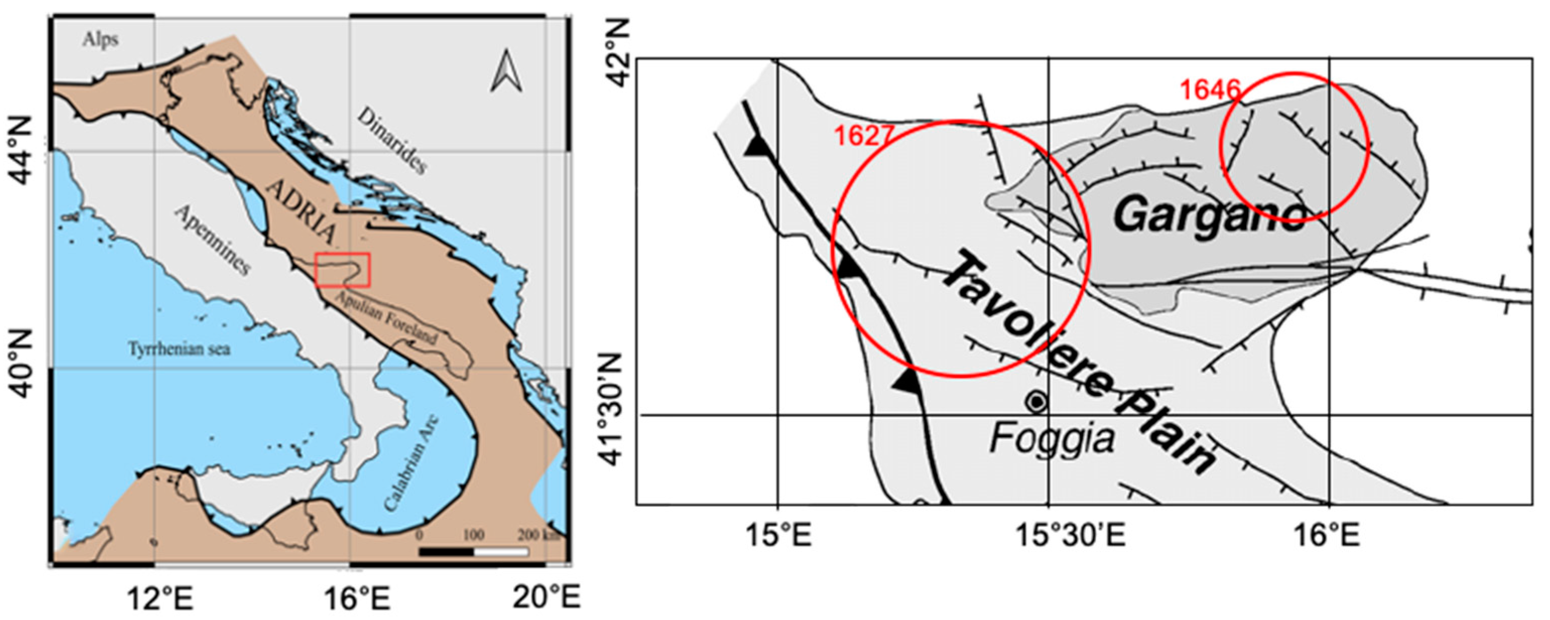
:1. Introduction
2. Data and Methods
2.1. Dataset
2.2. Coda Attenuation Method
2.3. Coda Attenuation 3D Imaging
3. Results
3.1. Qc Estimates
- An initial marker, named , placed after the S-wave arrival, when the envelope shows a decreasing trend;
- A terminal marker, named , placed before a bump, or an abrupt change of the slope, or when the oscillations cannot be distinguished from the seismic noise.
3.2. Qc Averaged
3.3. 3D Mapping
4. Discussion
5. Conclusions
- (1)
- (2)
- The presence of a low area, down to a depth of 16 km, suggesting a ductile regime in the upper/intermediate crust in the northeastern sector of the GP (zone labeled C (Figure 8c));
- (3)
- (4)
Author Contributions
Funding
Data Availability Statement
Acknowledgments
Conflicts of Interest
References
- Aki, K.; Chouet, B. Origin of Coda Waves: Source, Attenuation, and Scattering Effects. J. Geophys. Res. 1975, 80, 3322–3342. [Google Scholar] [CrossRef]
- Sato, H. Energy Propagation Including Scattering Effects Sengle Isotropic Scattering Approximation. J. Phys. Earth 1977, 25, 27–41. [Google Scholar] [CrossRef]
- Ibáñez, J.M.; Pezzo, E.D.; Miguel, F.D.; Herraiz, M.; Alguacil, G.; Morales, J. Depth-Dependent Seismic Attenuation in the Granada Zone (Southern Spain). Bull. Seismol. Soc. Am. 1990, 80, 1232–1244. [Google Scholar]
- Jin, A.; Aki, K. High-Resolution Maps of Coda Q in Japan and Their Interpretation by the Brittle-Ductile Interaction Hypothesis. Earth Planets Space 2005, 57, 403–409. [Google Scholar] [CrossRef] [Green Version]
- Carcolé, E.; Sato, H. Spatial Distribution of Scattering Loss and Intrinsic Absorption of Short-Period S Waves in the Lithosphere of Japan on the Basis of the Multiple Lapse Time Window Analysis of Hi-Net Data. Geophys. J. Int. 2010, 180, 268–290. [Google Scholar] [CrossRef] [Green Version]
- Wang, W.; Shearer, P.M. An Improved Method to Determine Coda-Q, Earthquake Magnitude, and Site Amplification: Theory and Application to Southern California. J. Geophys. Res. Solid Earth 2019, 124, 578–598. [Google Scholar] [CrossRef] [Green Version]
- Zeng, Y.; Su, F.; Aki, K. Scattering Wave Energy Propagation in a Random Isotropic Scattering Medium: 1. Theory. J. Geophys. Res. Solid Earth 1991, 96, 607–619. [Google Scholar] [CrossRef]
- Paasschens, J.C.J. Solution of the Time-Dependent Boltzmann Equation. Phys. Rev. E 1997, 56, 1135–1141. [Google Scholar] [CrossRef]
- Mayeda, K.; Koyanagi, S.; Hoshiba, M.; Aki, K.; Zeng, Y. A Comparative Study of Scattering, Intrinsic, and Coda Q−1 for Hawaii, Long Valley, and Central California between 1.5 and 15.0 Hz. J. Geophys. Res. Solid Earth 1992, 97, 6643–6659. [Google Scholar] [CrossRef]
- Sato, H.; Fehler, M.C.; Maeda, T. Envelope Synthesis Based on the Radiative Transfer Theory. In Seismic Wave Propagation and Scattering in the Heterogeneous Earth, 2nd ed.; Sato, H., Fehler, M.C., Maeda, T., Eds.; Springer: Berlin/Heidelberg, Germany, 2012; pp. 245–318. ISBN 978-3-642-23029-5. [Google Scholar]
- Del Pezzo, E.; Ibáñez, J.M. Seismic Coda-Waves Imaging Based on Sensitivity Kernels Calculated Using an Heuristic Approach. Geosciences 2020, 10, 304. [Google Scholar] [CrossRef]
- Shapiro, N.M. The Energy Partitioning and the Diffusive Character of the Seismic Coda. Bull. Seismol. Soc. Am. 2000, 90, 655–665. [Google Scholar] [CrossRef]
- Frankel, A.; Wennerberg, L. Energy-Flux Model of Seismic Coda: Separation of Scattering and Intrinsic Attenuation. Bull. Seismol. Soc. Am. 1987, 77, 1223–1251. [Google Scholar] [CrossRef]
- Singh, S.; Herrmann, R.B. Regionalization of Crustal Coda Q in the Continental United States. J. Geophys. Res. Solid Earth 1983, 88, 527–538. [Google Scholar] [CrossRef]
- Pacheco, C.; Snieder, R. Time-Lapse Traveltime Change of Singly Scattered Acoustic Waves. Geophys. J. Int. 2006, 165, 485–500. [Google Scholar] [CrossRef] [Green Version]
- Mayor, J.; Margerin, L.; Calvet, M. Sensitivity of Coda Waves to Spatial Variations of Absorption and Scattering: Radiative Transfer Theory and 2-D Examples. Geophys. J. Int. 2014, 197, 1117–1137. [Google Scholar] [CrossRef] [Green Version]
- Yoshimoto, K. Monte Carlo Simulation of Seismogram Envelopes in Scattering Media. J. Geophys. Res. Solid Earth 2000, 105, 6153–6161. [Google Scholar] [CrossRef]
- De Siena, L.; Del Pezzo, E.; Thomas, C.; Curtis, A.; Margerin, L. Seismic Energy Envelopes in Volcanic Media: In Need of Boundary Conditions. Geophys. J. Int. 2013, 195, 1102–1119. [Google Scholar] [CrossRef] [Green Version]
- Del Pezzo, E.; De La Torre, A.; Bianco, F.; Ibanez, J.; Gabrielli, S.; De Siena, L. Numerically Calculated 3D Space-Weighting Functions to Image Crustal Volcanic Structures Using Diffuse Coda Waves. Geosciences 2018, 8, 175. [Google Scholar] [CrossRef] [Green Version]
- Giampiccolo, E.; Del Pezzo, E.; Tuvé, T.; Grazia, G.D.; Ibáñez, J.M. 3-D Q-Coda Attenuation Structure at Mt. Etna (Italy). Geophys. J. Int. 2021, 227, 544–558. [Google Scholar] [CrossRef]
- Mayor, J.; Calvet, M.; Margerin, L.; Vanderhaeghe, O.; Traversa, P. Crustal Structure of the Alps as Seen by Attenuation Tomography. Earth Planet. Sci. Lett. 2016, 439, 71–80. [Google Scholar] [CrossRef]
- Sketsiou, P.; Napolitano, F.; Zenonos, A.; De Siena, L. New Insights into Seismic Absorption Imaging. Phys. Earth Planet. Inter. 2020, 298, 106337. [Google Scholar] [CrossRef]
- Filippucci, M.; Del Pezzo, E.; de Lorenzo, S.; Tallarico, A. 2D Kernel-Based Imaging of Coda-Q Space Variations in the Gargano Promontory (Southern Italy). Phys. Earth Planet. Inter. 2019, 297, 106313. [Google Scholar] [CrossRef]
- Tripaldi, S. Electrical signatures of a permeable zone in carbonates hosting local geothermal manifestations: Insights for the deep fluid flow in the Gargano area (south-eastern Italy). Boll. Di Geofis. Teori. Ed. Appl. 2020, 61, 219–232. [Google Scholar] [CrossRef]
- Della Vedova, B.D.; Bellani, S.; Pellis, G.; Squarci, P. Deep temperatures and surface heat flow distribution. In Anatomy of an Orogen: The Apennines and Adjacent Mediterranean Basins; Vai, G.B., Martini, I.P., Eds.; Springer: Dordrecht, The Netherlands, 2001; pp. 65–76. ISBN 978-94-015-9829-3. [Google Scholar]
- Miccolis, S.; Filippucci, M.; de Lorenzo, S.; Frepoli, A.; Pierri, P.; Tallarico, A. Seismogenic Structure Orientation and Stress Field of the Gargano Promontory (Southern Italy) From Microseismicity Analysis. Front. Earth Sci. 2021, 9, 179. [Google Scholar] [CrossRef]
- Filippucci, M.; Miccolis, S.; Castagnozzi, A.; Cecere, G.; de Lorenzo, S.; Donvito, G.; Falco, L.; Michele, M.; Nicotri, S.; Romeo, A.; et al. Seismicity of the Gargano Promontory (Southern Italy) after 7 Years of Local Seismic Network Operation: Data Release of Waveforms from 2013 to 2018. Data Brief 2021, 35, 106783. [Google Scholar] [CrossRef]
- Filippucci, M.; Pierri, P.; de Lorenzo, S.; Tallarico, A. The Stress Field in the Northern Apulia (Southern Italy), as Deduced from Microearthquake Focal Mechanisms: New Insight from Local Seismic Monitoring. In International Conference on Computational Science and Its Applications; Springer: Cham, Switzerland, 2020; Volume 12255 LNCS, pp. 914–927. [Google Scholar] [CrossRef]
- Del Gaudio, V.; Pierri, P.; Frepoli, A.; Calcagnile, G.; Venisti, N.; Cimini, G.B. A Critical Revision of the Seismicity of Northern Apulia (Adriatic Microplate—Southern Italy) and Implicationsfor the Identification of Seismogenic Structures. Tectonophysics 2007, 436, 9–35. [Google Scholar] [CrossRef]
- Mantovani, E.; Babbucci, D.; Viti, M.; Albarello, D.; Mugnaioli, E.; Cenni, N.; Casula, G. Post-late miocene kinematics of the adria microplate: Inferences from geological, geophysical and geodetic data. In The Adria Microplate: GPS Geodesy, Tectonics and Hazards; Pinter, N., Gyula, G., Weber, J., Stein, S., Medak, D., Eds.; Springer: Dordrecht, The Netherlands, 2006; pp. 51–69. [Google Scholar]
- Filippucci, M.; Miccolis, S.; Castagnozzi, A.; Cecere, G.; de Lorenzo, S.; Donvito, G.; Falco, L.; Michele, M.; Nicotri, S.; Romeo, A.; et al. Gargano Promontory (Italy) Microseismicity (2013-2018): Waveform Data and Earthquake Catalogue. Mendeley Data 2021, 3. [Google Scholar] [CrossRef]
- INGV. Seismological Data Centre Rete Sismica Nazionale (RSN). 2006, Approx. 20 GByte/day of New Waveform Data, Approx. 366 Active Seismic Stations, the Archive Totals to More Than 500 Distinct Seismic Stations. Available online: http://cnt.rm.ingv.it/instruments/network/IV (accessed on 28 May 2021).
- De Lorenzo, S.; Michele, M.; Emolo, A.; Tallarico, A. A 1D P-Wave Velocity Model of the Gargano Promontory (South-Eastern Italy). J. Seism. 2017, 21, 909–919. [Google Scholar] [CrossRef]
- Filippucci, M.; Tallarico, A.; Dragoni, M.; de Lorenzo, S. Relationship Between Depth of Seismicity and Heat Flow: The Case of the Gargano Area (Italy). Pure Appl. Geophys. 2019, 176, 2383–2394. [Google Scholar] [CrossRef]
- Milano, G.; Di Giovambattista, R.; Ventura, G. Seismic Constraints on the Present-Day Kinematics of the Gargano Foreland, Italy, at the Transition Zone between the Southern and Northern Apennine Belts. Geophys. Res. Lett. 2005, 32, L24308. [Google Scholar] [CrossRef] [Green Version]
- QGIS. Available online: https://www.qgis.org/it/site/index.html (accessed on 28 May 2021).
- University of Bari “Aldo Moro” OTRIONS, Seismic Networks of Gargano Area (Italy). 2013. Available online: https://www.fdsn.org/networks/detail/OT/ (accessed on 28 May 2021).
- Aki, K. Analysis of the Seismic Coda of Local Earthquakes as Scattered Waves. J. Geophys. Res. 1969, 74, 615–631. [Google Scholar] [CrossRef]
- De Lorenzo, S.; Del Pezzo, E.; Bianco, F. Qc, Qβ, Qi and Qs Attenuation Parameters in the Umbria–Marche (Italy) Region. Phys. Earth Planet. Inter. 2013, 218, 19–30. [Google Scholar] [CrossRef]
- Kumar, N.; Parvez, I.A.; Virk, H.S. Estimation of Coda Wave Attenuation for NW Himalayan Region Using Local Earthquakes. Phys. Earth Planet. Inter. 2005, 151, 243–258. [Google Scholar] [CrossRef]
- Romanowicz, B.; Mitchell, B.J. Q of the Earth: Global, Regional, and Laboratory Studies; Birkhäuser: Basel, Switzerland, 2012; ISBN 978-3-0348-8711-3. [Google Scholar]
- Eva, C.; Cattaneo, M.; Augliera, P.; Pasta, M. Regional Coda Q Variations in the Western Alps (Northern Italy). Phys. Earth Planet. Inter. 1991, 67, 76–86. [Google Scholar] [CrossRef]
- Singh, D.D.; Govoni, A.; Bragato, P.L. Coda QcAttenuation and Source Parameter Analysis in Friuli (NE Italy) and Its Vicinity. Pure Appl. Geophys. 2001, 158, 1737–1761. [Google Scholar] [CrossRef]
- Giampiccolo, E.; Tuvè, T. Regionalization and Dependence of Coda Q on Frequency and Lapse Time in the Seismically Active Peloritani Region (Northeastern Sicily, Italy). J. Seism. 2018, 22, 1059–1074. [Google Scholar] [CrossRef]
- Tuvè, T.; Bianco, F.; Ibáñez, J.; Patanè, D.; Del Pezzo, E.; Bottari, A. Attenuation Study in the Straits of Messina Area (Southern Italy). Tectonophysics 2006, 421, 173–185. [Google Scholar] [CrossRef]
- Giampiccolo, E.; Tusa, G.; Langer, H.; Gresta, S. Attenuation in Southeastern Sicily (Italy) by Applying Different Coda Methods. J. Seismol. 2002, 6, 487–501. [Google Scholar] [CrossRef]
- Pujades, L.G.; Ugalde, A.; Canas, J.A.; Navarro, M.; Badal, F.J.; Corchete, V. Intrinsic and Scattering Attenuation from Observed Seismic Codas in the Almeria Basin (Southeastern Iberian Peninsula). Geophys. J. Int. 1997, 129, 281–291. [Google Scholar] [CrossRef] [Green Version]
- Dasović, I.; Herak, M.; Herak, D. Coda-Q and Its Lapse Time Dependence Analysis in the Interaction Zone of the Dinarides, the Alps and the Pannonian Basin. Phys. Chem. Earth Parts A/B/C 2013, 63, 47–54. [Google Scholar] [CrossRef]
- Boulanouar, A.; Moudnib, L.E.; Padhy, S.; Harnafi, M.; Villaseñor, A.; Gallart, J.; Pazos, A.; Rahmouni, A.; Boukalouch, M.; Sebbani, J. Estimation of Coda Wave Attenuation in Northern Morocco. Pure Appl. Geophys. 2018, 175, 883–897. [Google Scholar] [CrossRef]
- Shengelia, I.; Jorjiashvili, N.; Godoladze, T.; Javakhishvili, Z.; Tumanova, N. Intrinsic and Scattering Attenuations in the Crust of the Racha Region, Georgia. J. Earthq. Tsunami 2019, 14, 2050006. [Google Scholar] [CrossRef]
- Gupta, A.K.; Sutar, A.K.; Chopra, S.; Kumar, S.; Rastogi, B.K. Attenuation Characteristics of Coda Waves in Mainland Gujarat (India). Tectonophysics 2012, 530–531, 264–271. [Google Scholar] [CrossRef]
- Kandel, T.P.; Yamada, M.; Pokhrel, P. Determination of High-Frequency Attenuation Characteristic of Coda Waves in the Central Region of Nepal Himalaya. J. Nepal Geol. Soc. 2020, 60, 75–86. [Google Scholar] [CrossRef]
- Mukhopadhyay, S.; Tyagi, C. Lapse Time and Frequency-Dependent Attenuation Characteristics of Coda Waves in the Northwestern Himalayas. J. Seism. 2007, 11, 149–158. [Google Scholar] [CrossRef]
- Thirunavukarasu, A.; Kumar, A.; Mitra, S. Lateral Variation of Seismic Attenuation in Sikkim Himalaya. Geophys. J. Int. 2017, 208, 257–268. [Google Scholar] [CrossRef]
- Chung, J.-K.; Chen, Y.-L.; Shin, T.-C. Spatial Distribution of Coda Q Estimated from Local Earthquakes in Taiwan Area. Earth Planet Space 2009, 61, 1077–1088. [Google Scholar] [CrossRef] [Green Version]
- Kosuga, M. Dependence of Coda Q on Frequency and Lapse Time in the Western Nagano Region, Central Japan. J. Phys. Earth 1992, 40, 421–445. [Google Scholar] [CrossRef]
- Parvez, I.A.; Sutar, A.K.; Mridula, M.; Mishra, S.K.; Rai, S.S. Coda Q Estimates in the Andaman Islands Using Local Earthquakes. Pure Appl. Geophys. 2008, 165, 1861–1878. [Google Scholar] [CrossRef]
- Vieira Barros, L.; Assumpção, M.; Quintero, R.; Ferreira, V.M. Coda Wave Attenuation in the Parecis Basin, Amazon Craton, Brazil: Sensitivity to Basement Depth. J. Seism. 2011, 15, 391–409. [Google Scholar] [CrossRef]
- Biescas, B.; Rivera, Z.; Zapata, J.A. Seismic Attenuation of Coda Waves in the Eastern Region of Cuba. Tectonophysics 2007, 429, 99–109. [Google Scholar] [CrossRef]
- Dobrynina, A.A.; Albaric, J.; Deschamps, A.; Perrot, J.; Ferdinand, R.W.; Déverchère, J.; San’kov, V.A.; Chechel’nitskii, V.V. Seismic Wave Attenuation in the Lithosphere of the North Tanzanian Divergence Zone (East African Rift System). Russ. Geol. Geophys. 2017, 13, 253–265. [Google Scholar] [CrossRef]
- Bianco, F.; Pezzo, E.D.; Malagnini, L.; Luccio, F.D.; Akinci, A. Separation of Depth-Dependent Intrinsic and Scattering Seismic Attenuation in the Northeastern Sector of the Italian Peninsula. Geophys. J. Int. 2005, 161, 130–142. [Google Scholar] [CrossRef] [Green Version]
- Bianco, F.; Del Pezzo, E.; Castellano, M.; Ibanez, J.; Di Luccio, F. Separation of Intrinsic and Scattering Seismic Attenuation in the Southern Apennine Zone, Italy. Geophys. J. Int. 2002, 150, 10–22. [Google Scholar] [CrossRef]
- Del Pezzo, E.; Giampiccolo, E.; Tuvé, T.; Di Grazia, G.; Gresta, S.; Ibàñez, J.M. Study of the Regional Pattern of Intrinsic and Scattering Seismic Attenuation in Eastern Sicily (Italy) from Local Earthquakes. Geophys. J. Int. 2019, 218, 1456–1468. [Google Scholar] [CrossRef]
- Hoshiba, M. Simulation of Multiple-Scattered Coda Wave Excitation Based on the Energy Conservation Law. Phys. Earth Planet. Inter. 1991, 67, 123–136. [Google Scholar] [CrossRef]
- Padhy, S.; Subhadra, N.; Kayal, J.R. Frequency-Dependent Attenuation of Body and Coda Waves in the Andaman Sea Basin. Bull. Seismol. Soc. Am. 2011, 101, 109–125. [Google Scholar] [CrossRef]
- Farrokhi, M.; Hamzehloo, H.; Rahimi, H.; Allameh Zadeh, M. Separation of Intrinsic and Scattering Attenuation in the Crust of Central and Eastern Alborz Region, Iran. Phys. Earth Planet. Inter. 2016, 253, 88–96. [Google Scholar] [CrossRef]
- Akinci, A.; Del Pezzo, E.; Ibáñez, J.M. Separation of Scattering and Intrinsic Attenuation in Southern Spain and Western Anatolia (Turkey). Geophys. J. Int. 1995, 121, 337–353. [Google Scholar] [CrossRef] [Green Version]
- Jin, A.; Aki, K. Spatial and Temporal Correlation between Coda Q−1 and Seismicity and Its Physical Mechanism. J. Geophys. Res. Solid Earth 1989, 94, 14041–14059. [Google Scholar] [CrossRef]
- Sharma, B.; Teotia, S.S.; Kumar, D. Attenuation of P, S, and Coda Waves in Koyna Region, India. J. Seism. 2007, 11, 327–344. [Google Scholar] [CrossRef]
- Morozov, I.B. Geometrical Attenuation, Frequency Dependence of Q, and the Absorption Band Problem. Geophys. J. Int. 2008, 175, 239–252. [Google Scholar] [CrossRef] [Green Version]
- Rovida, A.; Locati, M.; Camassi, R.; Lolli, B.; Gasperini, P. The Italian Earthquake Catalogue CPTI15. Bull. Earthq. Eng. 2020, 18, 2953–2984. [Google Scholar] [CrossRef]
- Loddo, M.; Quarto, R.; Schiavone, D. Integrated Geophysical Survey for the Geological Structural and Hydrogeothermal Study of the North-Western Gargano Promontory (Southern Italy). Ann. Geophys. 1996, 39. [Google Scholar] [CrossRef]
- Catalano, R.; Di Stefano, P.; Nigro, F.; Vitale, F.P. The Sicily mainland thrust belt: Evolution during the Neogene. Boll. Geofis. Teor. Appl. 1994, 36, 127–138. [Google Scholar]


| This Study | Radius of Investigation (km) 1 | |
|---|---|---|
| s | = 11 ± 9; = 0.96 ± 0.07 | 19.3 |
| s | = 24 ± 15; = 0.80 ± 0.11 | 29.9 |
| s | = 31 ± 15; = 0.88 ± 0.10 | 38.6 |
| s | = 34 ± 13; = 0.97 ± 0.09 | 48.2 |
| s | = 40 ± 14; = 1.00 ± 0.10 | 57.9 |
| s | = 49 ± 16; = 1.00 ± 0.11 | 67.5 |
| s | = 63 ± 20; = 0.95 ± 0.15 | 77.2 |
| Region | |||
|---|---|---|---|
| Gargano (Italy) [this study] | 63 | 1 | 40 |
| Gargano (Italy) [23] | 50 | 0.7 | 40 |
| Mts. Peloritani (Italy) [44] | 50 | 0.7 | 40 |
| Messina Strait (Italy) [45] | 76 | 0.5 | 40 |
| Southeastern Sicily (Italy) [46] | 38 | 1.4 | 40 |
| Central Appennines (Italy) [39] | 88 | 0.6 | 40 |
| Granada Zone (Southern Spain) [3] | 86 | 0.9 | 40 |
| Almeria Basin (Iberian Peninsula) [47] | 63 | 0.9 | 40 |
| Pannonian Basin (Croazia) [48] | 108 | 0.7 | 40 |
| Northern Morocco [49] | 140 | 0.9 | 40 |
| Racha Region (Georgia) [50] | 79 | 1 | 60 |
| Mainland Gujarat (India) [51] | 112 | 0.9 | 40 |
| Nepal Himalaya [52] | 143 | 1 | 40 |
| Northwestern Himalaya [53] | 150 | 1 | 30 |
| Sikkin Himalaya [54] | 91 | 1 | 40 |
| Taiwan [55] | 93 | 0.8 | 30 |
| Western Nagao, Japan [56] | 112 | 0.7 | 30 |
| Andaman Islands [57] | 122 | 0.8 | 40 |
| Parecis Basin (Brazil) [58] | 98 | 1.2 | 40 |
| Eastern Cuba [59] | 64 | 0.8 | 20 |
| North Tanzania [60] | 146 | 1 | 40 |
Publisher’s Note: MDPI stays neutral with regard to jurisdictional claims in published maps and institutional affiliations. |
© 2021 by the authors. Licensee MDPI, Basel, Switzerland. This article is an open access article distributed under the terms and conditions of the Creative Commons Attribution (CC BY) license (https://creativecommons.org/licenses/by/4.0/).
Share and Cite
Filippucci, M.; Lucente, S.; Del Pezzo, E.; de Lorenzo, S.; Prosser, G.; Tallarico, A. 3D-Kernel Based Imaging of an Improved Estimation of (Qc) in the Northern Apulia (Southern Italy). Appl. Sci. 2021, 11, 7512. https://doi.org/10.3390/app11167512
Filippucci M, Lucente S, Del Pezzo E, de Lorenzo S, Prosser G, Tallarico A. 3D-Kernel Based Imaging of an Improved Estimation of (Qc) in the Northern Apulia (Southern Italy). Applied Sciences. 2021; 11(16):7512. https://doi.org/10.3390/app11167512
Chicago/Turabian StyleFilippucci, Marilena, Salvatore Lucente, Edoardo Del Pezzo, Salvatore de Lorenzo, Giacomo Prosser, and Andrea Tallarico. 2021. "3D-Kernel Based Imaging of an Improved Estimation of (Qc) in the Northern Apulia (Southern Italy)" Applied Sciences 11, no. 16: 7512. https://doi.org/10.3390/app11167512