WebGIS Implementation for Dynamic Mapping and Visualization of Coastal Geospatial Data: A Case Study of BESS Project
Abstract
:1. Introduction
- -
- A methodological approach for the implementation of a WebGIS necessary for a very detailed dynamic mapping and visualization of geospatial coastal data.
- -
- The description of the dataset necessary for the monitoring of coastal areas, especially the PBs.
- -
- A demonstration of a case study for the PBs of Sicily and Malta by using the methodology and the dataset used during the BESS project.
2. Materials and Methods
2.1. Study Area
2.2. Dataset Preparation and Data Description
2.3. Methodology
- -
- WebGIS: publication of geographic information data through an interactive web page that does not require the use of specific GIS software for their use.
- -
- Geo web service: a particular architecture that allows the return of geographic data located remotely through specific protocols, following a request made either through a simple web browser or through specific client applications.
3. Results
3.1. WebGIS Visualization and Mapping
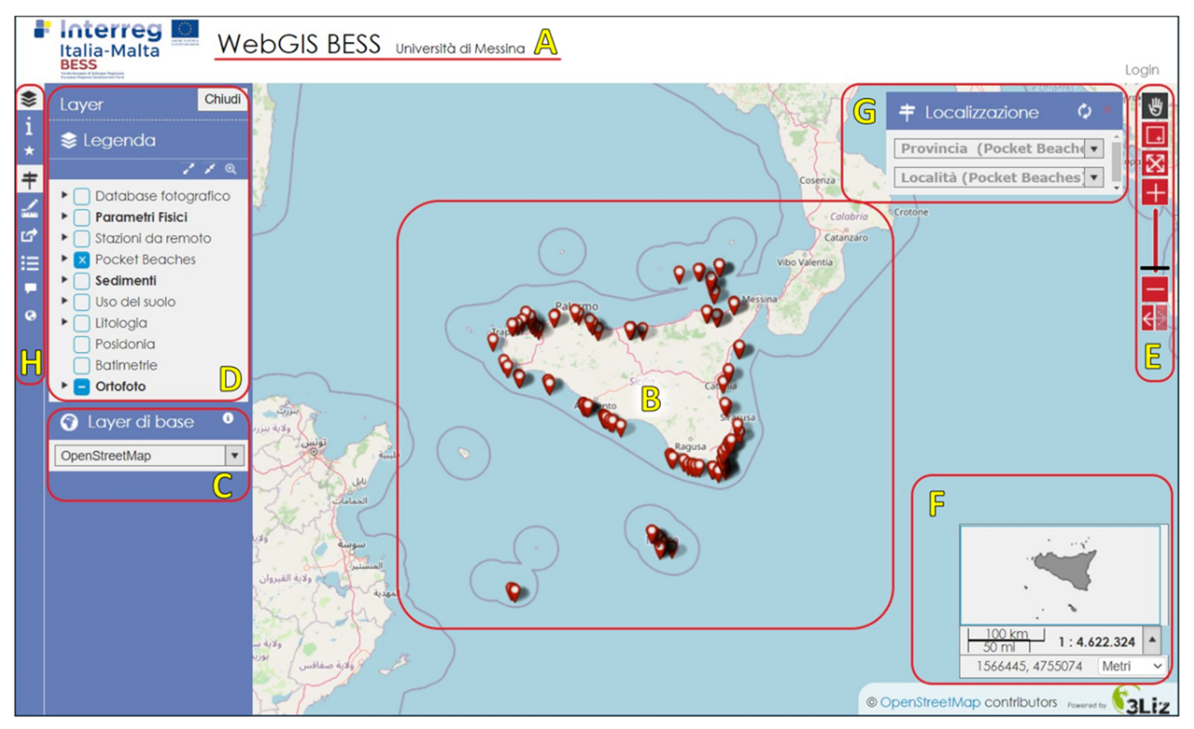
- Title of the web window reflecting the container of all the information relating to the project.
- Initial map with the default scale set
- Tool that allows for activating or deactivating of a basemap layer from the map background. In this study, OpenStreetMap was used due to the amount of information it contains.
- The legend lists the various data layers (raster and vector) in order of overlap, inserted within the map; both single and multi-layers may be accessed. Some layers can be grouped according to the composition of the project. By clicking on the small triangle
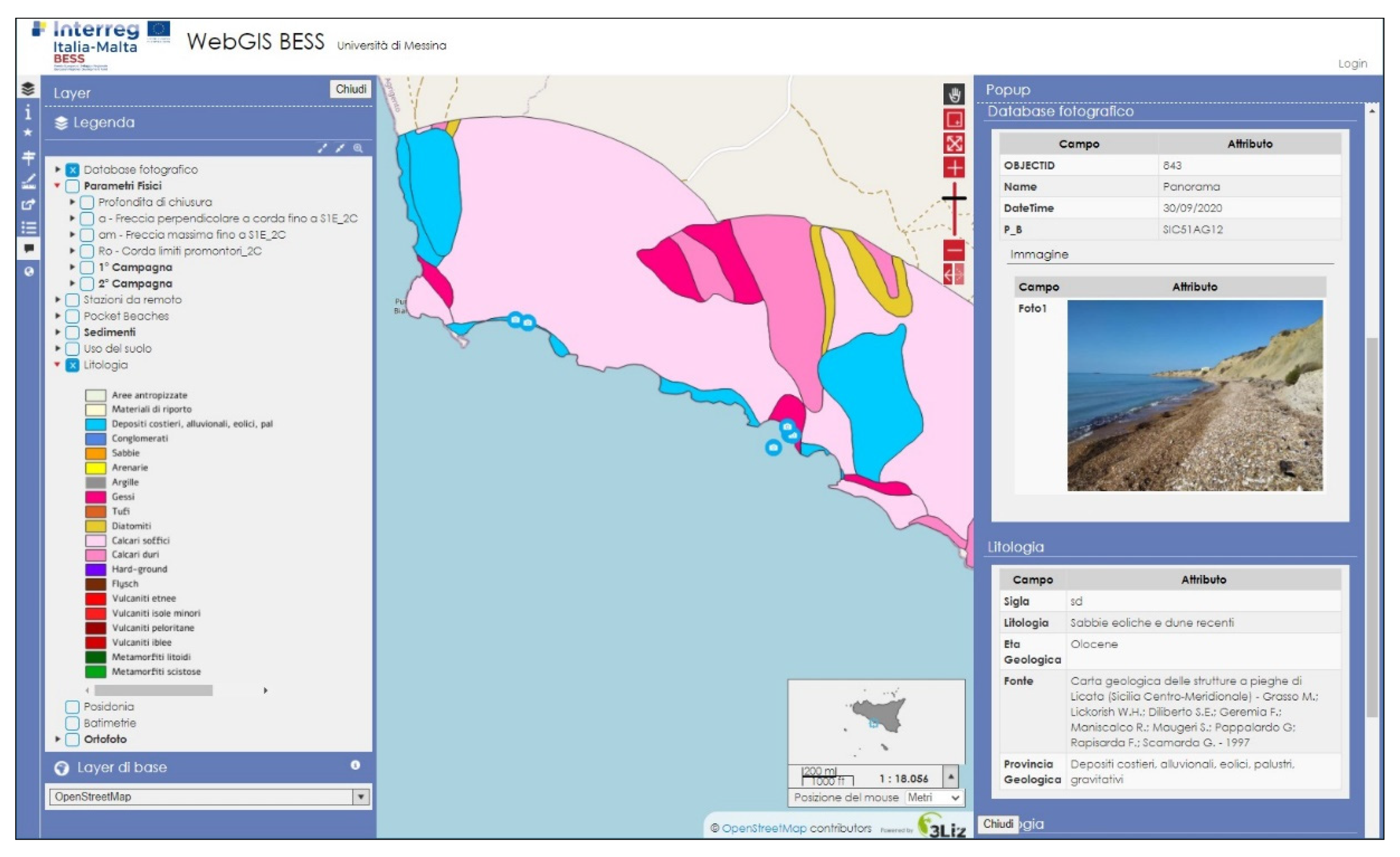
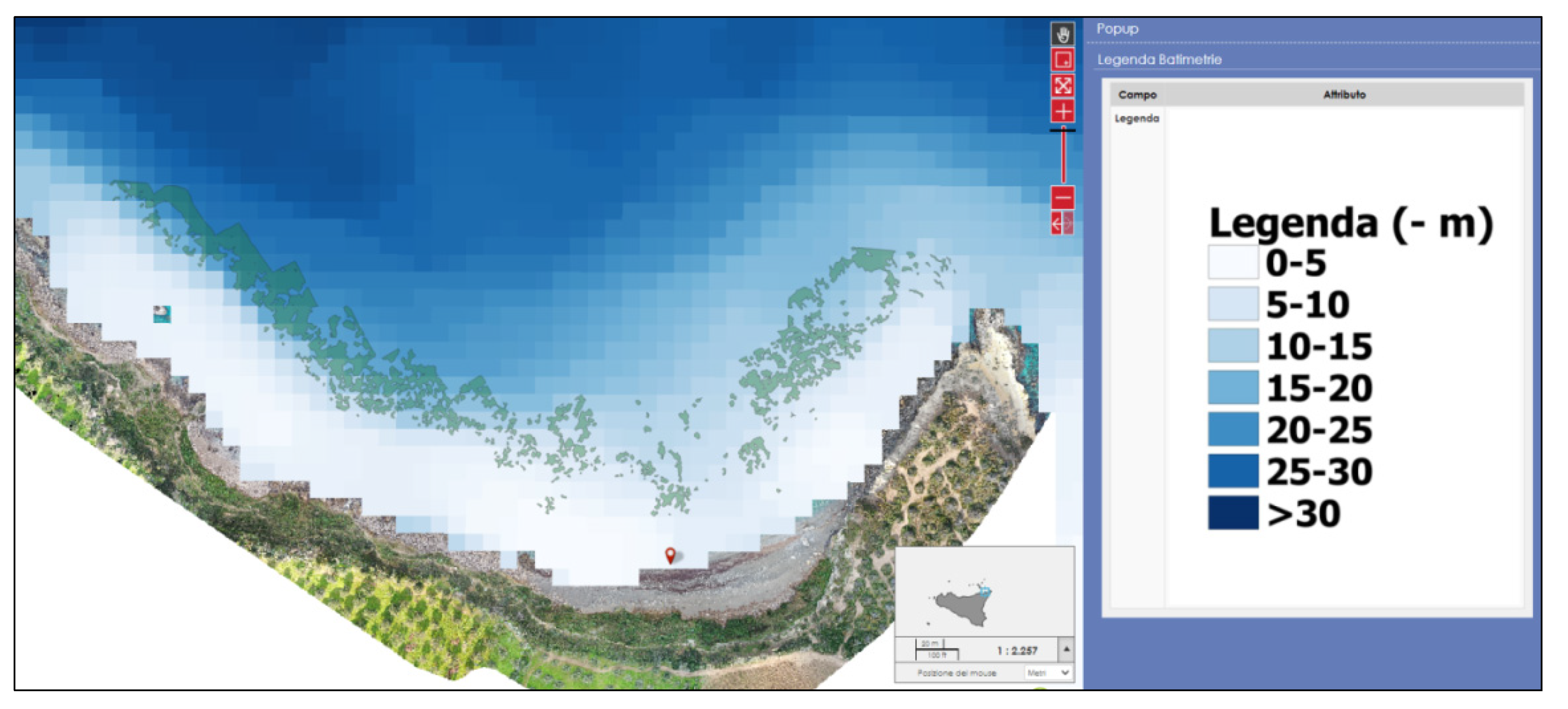
on the left of each layer, the relative symbol will appear, opening the data related to the information layer. By selecting a specific layer, it will be possible to obtain relevant information, like its spatial extension, or to modify, with various levels, its degree of opacity. Once any layer is activated, it will appear in the map according to a presentation style previously created in QGIS. By clicking with the left mouse button on any vector element, a popup window will appear on the right containing the information of the objects positioned in that particular point (Figure 5).
- This tool allows navigation of the map through various buttons:
- (1).
Pan—the horizontal shift (the hand sign symbol) allows movement around the map by clicking and holding the left mouse button. It is also possible to use the mouse wheel, both forwards and backwards, thus activating the modification of the scale, keeping the mouse cursor in the center of the map;
- (2).
Zoom window (red plus symbol), which allows a specific zoom by dragging the pointer in order to draw a rectangle, which then defines the area of interest to be scaled;
- (3).
Zoom to initial map extension’s symbol allows zoom of the starting map;
- (4).
Zoom in—zoom out’s symbol allows selection of the zoom level through a scale bar;
- (5).
Previous and next zoom: these two indicators allow one to scroll through the zoom history.
- The panel displaying the map overview uses a blue square highlight to indicate the current surface shown on the map. Furthermore, a scale bar and coordinates of the cursor point position based on the reference system set are also shown inside this panel, in this case UTM WGS84 33N. It is possible to change the map view by moving the blue square on the overview. In the lower right corner, there is also the exact geographical position. Finally, a small drop-down menu also allows choosing the unit of measurement (meters/degrees/degrees and minutes/degrees, minutes, and seconds).
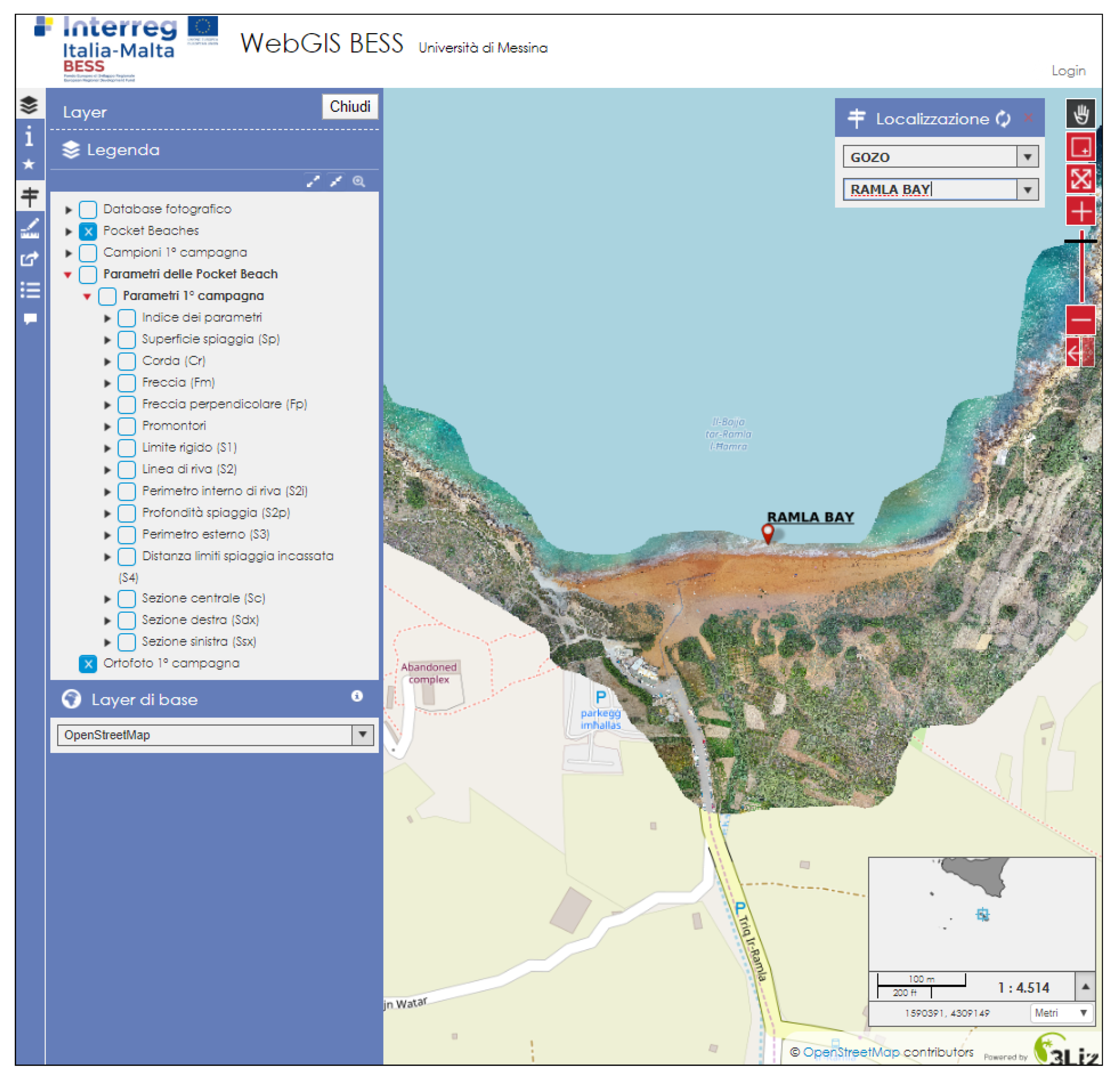
- The location tool allows a specific position to be reached, based on any categorized item of the project, in this case, an individual PB under study. These actions are initially carried out by identifying the area in which the various PBs are grouped, for example, the Sicilian Provinces (Messina, Palermo, Catania, Syracuse, Ragusa, Agrigento, and Trapani), Malta, Gozo, and Comino. Once this parameter has been identified, the beaches discriminated for that area will appear in the second window; by selecting the latter, it will appear on the map to the same extent as the selected geometric object (Figure 6).The activated layer corresponds to the orthophoto.
- Toolbar
Layer symbol activates or deactivates the layer management panel and its legend (D)
Information allows obtaining information relating to the map description, set properties, contacts of the person responsible for the published data, and other features.
Star tool allows selecting and filtering the geometries of a single layer into the map using various tools, and, subsequently, displays in the attributes table.
Localization symbol activates or deactivates the localization tool (G).
By clicking Ruler tool it is possible to choose the type of the activated measure (length, area, and perimeter).
Permalink allows users to obtain an external link that will allow them to save the map in the exact extension, projection, and scale of that moment.
Table attribute symbol activates the attribute tables of the vector layers present in the project, with the possibility to sort and select the fields, as well as to filter them in order to make comparisons.
Popup (message) symbol represents the pop-up window for the information of the selected data.
Atlas (globe) symbol represents the atlas, or a sequential display of a given layer. In this case the single PBs layer was chosen for display. It is also possible to automatically reproduce the sequence of the beaches using the “play” button.
3.2. Examples of Comparison
4. Discussion
- (1)
- The creation of a management model extended to a sufficiently large area.
- (2)
- Ensuring that planning is functional to the defense of the natural asset and its conscious and sustainable use.
- (3)
- Making the model implementable continuously, wherever possible involving local administrations, and available to public and private users, using state of the art technologies.
5. Conclusions
Author Contributions
Funding
Institutional Review Board Statement
Data Availability Statement
Acknowledgments
Conflicts of Interest
Appendix A
| Layer | Description |
|---|---|
| Orthophotos and satellite images |
|
| Beach sediment samples | Sedimentological parameters (Folk and Ward [73]). |
| Geometric and geomorphological parameters |
|
| Lithology | Within a 1 km buffer from the shoreline |
| Land use | Extracted from Sentinel-2 images for 500 m surface from the shoreline. |
| Bathymetry | By satellite images (the degree of precision is related to the quality images) |
| Posidonia oceanica | Mapping of the shallow water Posidonia oceanica, extracted from the clearest orthophotos |
| In situ photo collection | Pictures of the beaches from different point of view |
| Remote surveillance system | Two types of monitoring systems: photographic/climatic stations and stations with accelerometer and velocimetric devices |
References
- Caiaffa, E. Un Percorso Attraverso Concetti e Nozioni Fondamentali Per Addentrarsi Nel Vasto Mondo Della Scienza Della Informazione Geografica; ENEA: Roma, Italy, 2006; p. 1922. [Google Scholar]
- Bhat, M.A.; Shah, R.M.; Ahmad, B. Cloud computing: A solution to geographical information systems (GIS). Inter. J. Comp. Sci. Eng. 2011, 3, 594–600. [Google Scholar]
- Dragicevic, S. The potential of Web-based GIS. J. Geogr. Syst. 2004, 6, 79–81. [Google Scholar] [CrossRef]
- Barricelli, B.R.; Maiellaro, N.; Padula, M.; Scala, P.L. Dal GIS al WebGIS in Ambiente Open Source. L’edilizia 2009, 23, 94–97. [Google Scholar]
- De Castro, A.F.; Amaro, V.E.; Grigio, A.M.; Cavalcante, R.G. Modeling and development of a WebGis for environmental monitoring of coastal areas that are influenced by the oil industry. J. Coast. Res. 2011, 64, 1643–1647. [Google Scholar]
- Tang, W.; Selwood, J. Connecting Our World: GIS Web Services; ESRI Press: Hong Kong, 2003. [Google Scholar]
- Opdam, P. Learning science from practice. Landsc. Ecol. 2010, 25, 821–823. [Google Scholar] [CrossRef] [Green Version]
- Veenendaal, B.; Brovelli, M.A.; Li, S. Review of Web Mapping: Eras, Trends and Directions. ISPRS Int. J. Geo-Inf. 2017, 6, 317. [Google Scholar] [CrossRef]
- Lopes, S.I.; Moreira, P.M.; Cruz, A.M.; Martins, P.; Pereira, F.; Curado, A. RnMonitor: A WebGIS-based platform for expedite in situ deployment of IoT edge devices and effective Radon Risk Management. In Proceedings of the 2019 IEEE International Smart Cities Conference (ISC2), Casablanca, Morocco, 14–17 October 2019; pp. 451–457. [Google Scholar]
- Pan, S.; Wang, K.; Wang, L.; Wang, Z.; Han, Y. Risk Assessment System Based on WebGIS for Heavy Metal Pollution in Farmland Soils in China. Sustainability 2017, 9, 1846. [Google Scholar] [CrossRef] [Green Version]
- Howell, R.G.; Petersen, S.L.; Balzotti, C.S.; Rogers, P.C.; Jackson, M.W.; Hedrich, A.E. Using WebGIS to Develop a Spatial Bibliography for Organizing, Mapping, and Disseminating Research Information: A Case Study of Quaking Aspen. Angelands 2019, 41, 244–247. [Google Scholar] [CrossRef]
- Seng, B.; Liang, H.; Zhao, Y.; Tang, Y. Design and Implementation of Visualization System for Wastewater Treatment in Dianchi Lake Based on WebGIS. E3S Web Conf. 2019, 118, 04032. [Google Scholar] [CrossRef]
- Luo, K.; Zhang, T.; Liu, Y. Design and Implementation of the Water Environment Monitoring and Management System Based on WebGIS for the Four-Lake Basin of Hubei Province. E3S Web Conf. 2019, 136, 06036. [Google Scholar] [CrossRef]
- Villani, G.; Nanni, S.; Tomei, F.; Pasetti, S.; Mangiaracina, R.; Agnetti, A.; Leoni, P.; Folegani, M.; Mazzini, G.; Botarelli, L.; et al. The RainBO Platform for Enhancing Urban Resilience to Floods: An Efficient Tool for Planning and Emergency Phases. Climate 2019, 7, 145. [Google Scholar] [CrossRef] [Green Version]
- Santoso, M.I.; Gumelar, R.G.; Irawan, B. Development of the WebGIS application for transport infrastructure management in the city of Serang. IOP Conf. Ser. Mater. Sci. Eng. 2019, 673, 012072. [Google Scholar] [CrossRef]
- Stanković, R.; Vulović, N.; Lilić, N.; Obradović, I.; Tošović, R.; Pešić-Georgiadis, M. A WebGIS Decision Support System for Management of Abandoned Mines. Energies 2016, 9, 567. [Google Scholar] [CrossRef] [Green Version]
- Wirkus, L. An Open Source WebGIS Application for Civic Education on Peace and Conflict. ISPRS Int. J. Geo-Inf. 2015, 4, 1013–1032. [Google Scholar] [CrossRef] [Green Version]
- Ahmed, B.; Rahman, M.S.; Islam, R.; Sammonds, P.; Zhou, C.; Uddin, K.; Al-Hussaini, T.M. Developing a Dynamic Web-GIS Based Landslide Early Warning System for the Chittagong Metropolitan Area, Bangladesh. ISPRS Int. J. Geo-Inf. 2018, 7, 485. [Google Scholar] [CrossRef] [Green Version]
- Lathrop, R.; Auermuller, L.; Trimble, J.; Bognar, J. The Application of WebGIS Tools for Visualizing Coastal Flooding Vulnerability and Planning for Resiliency: The New Jersey Experience. ISPRS Int. J. Geo-Inf. 2014, 3, 408–429. [Google Scholar] [CrossRef]
- Oliveira, A.; Jesus, G.; Gomes, G.L.; Rogeiro, J.; Azevedo, A.; Rodrigues, M.; Fortunato, A.B.; Dias, D.M.; Tomas, L.M.; Vaz, L.; et al. An interactive WebGIS observatory platform for enhanced support of integrated coastal management. J. Coast. Res. 2014, 70, 507–512. [Google Scholar] [CrossRef]
- Gourmelon, F.; Le Guyader, D.; Fontenelle, G. A dynamic GIS an Efficient Tool for Integrated Coastal zone Management. ISPR Int. J. Geo-Inf. 2014, 3, 391–407. [Google Scholar] [CrossRef] [Green Version]
- Hansen, H.S.; Fuglsang, M. An Operational Web-Based Indicator System for Integrated Coastal Zone Management. ISPRS Int. J. Geo-Inf. 2014, 3, 326–344. [Google Scholar] [CrossRef] [Green Version]
- Available online: https://webgis.provincia.belluno.it/ (accessed on 5 August 2021).
- Available online: http://www.webgis.arpa.puglia.it/ (accessed on 5 August 2021).
- Available online: https://webgis.cittametropolitana.ve.it/lm/ (accessed on 5 August 2021).
- Peng, Z.R.; Tsou, M. Internet GIS: Distributed Geographic Information Services for the Internet and Wireless Networks; John Wiles and Sons Inc.: Hoboken, NJ, USA, 2003. [Google Scholar]
- Haklay, M.; Singleton, A.; Parker, C. Web Mapping 2.0: The Neogeography of the GeoWeb. Geogr. Compass 2008, 2, 2011–2039. [Google Scholar]
- Fu, P.; Sun, J. Webgis Principles and Application; ESRI Press: Redlands, CA, USA, 2010. [Google Scholar]
- Zhang, X.; Yao, J.; Zhu, C.; Li, Y.; Ding, X. A WebGis for Spatial Data Processing, Analysis and Distribution for Coastal Investigation and Assessment (Mission 908) in Jiangsu, China. The International Archives of the Photogrammetry, Remote Sensing and Spatial Information Sciences. Part B4 Beijing, 2008, XXXVII.B. Available online: https://isprs.org/proceedings/XXXVII/congress/4_pdf/140.pdf (accessed on 5 August 2021).
- Silverster, R.; Tsuchiya, Y.; Shibano, T. Zeta Bays, Pocket Beaches and Headland Control. In Proceedings of the 17th International Conference on Coastal Engineering, Sydney, Australia, 23–28 March 1980; pp. 1306–1319. [Google Scholar]
- Komar, P.D. Rhythmic Shoreline Features and Their Origins. In Mega-Geomorphology; Gardner, R., Scoging, H., Eds.; Clarendon Press: Oxford, UK, 1983; pp. 92–112. [Google Scholar]
- Uda, T.; Serizawa, M.; San-Nami, T.; Furuike, K. Shoreline changes of a pocket beach caused by elongationof harbor breackwater and their prediction. Trans. Jpn. Geomorphol. Union 2002, 23, 395–413. [Google Scholar]
- Hsu, J.R.C.; Yu, M.J.; Lee, F.C.; Benedet, L. Static Bay beach concept for scientists and engineers: A review. Coast. Eng. 2010, 57, 76–91. [Google Scholar] [CrossRef]
- Short, A.D. Role of geological inheritance in Australian beach morphodynamics. Coast. Eng. 2010, 57, 92–97. [Google Scholar] [CrossRef]
- Pranzini, E.; Rosas, V.; Jackson, N.L.; Nordstrom, K.F. Beach changes from sediment delivered by streams to pocketbeaches during a major flood. Geomorphology 2013, 199, 36–47. [Google Scholar] [CrossRef]
- Short, A.D.; Masselik, G. Embayed and Structurally Controlled Beaches. In Handbook of Beach and Shoreface Morphodynamics; Short, A.D., Ed.; John Willey & Sons: New York, NY, USA, 1999; pp. 230–249. [Google Scholar]
- Bowman, D.; Rosas, V.; Pranzini, E. Pocket beaches of Elba Island (Italy)—Planview geometry, depth of closure and sediment dispersal. Estuar. Coast. Shelf Sci. 2014, 138, 37–46. [Google Scholar] [CrossRef]
- Hsu, J.R.C.; Evans, C. Parabolic bay shapes and applications. Proc. Inst. Civil Eng. 1989, 2, 557–570. [Google Scholar] [CrossRef]
- Silvester, R.; Hsu, J.R.C. Coastal Stabilization: Innovative Concepts; Prentice-Hall: Englewood Cliffs, NJ, USA, 1993; p. 578. [Google Scholar]
- Klein, A.H.F.; Filho, L.B.; Schumacher, D.H. Short-term beach rotation processes in distinct headland bay beach systems. J. Coast. Res. 2002, 18, 442–458. [Google Scholar]
- Hsu, J.; Benedet, L.; Klein, A.H.; Raabe, A.; Tsai, C.-P.; Hsu, T. Appreciation of static bay beach concept for coastal management and protection. J. Coast. Res. 2008, 24, 198–215. [Google Scholar] [CrossRef]
- Bowman, D.; Guillen, J.; Lopez, L.; Pellegrino, V. Planview Geometry and morphological characteristics of pocket beaches on the Catalan coast (Spain). Geomorphology 2009, 108, 191–199. [Google Scholar] [CrossRef]
- Brignone, M.; Schiaffino, C.F.; Isla, F.I.; Ferrari, M. A system for beach video-monitoring: Beachkeeper plus. Comput. Geosci. 2012, 49, 53–61. [Google Scholar] [CrossRef]
- Simeone, S.; Palombo, L.; De Falco, G. Morphodynamics of a Nontidal Embayed Beach: The Case Study of Is Arutas (Western Mediterranean). J. Coast. Res. 2013, 29, 63–71. [Google Scholar] [CrossRef]
- Cappadonia, C.; Coratza, P.; Agnesi, V.; Soldati, M. Malta and Sicily Joined by Geoheritage Enhancement and Geotourism within the Framework of Land Management and Development. Geosciences 2018, 8, 253. [Google Scholar] [CrossRef] [Green Version]
- Furlani, S.; Antonioli, F.; Biolchi, S.; Gambin, T.; Gauci, R.; Lo Presti, V.; Sulli, A. Holocene sea level change in Malta. Quat. Int. 2013, 288, 146–157. [Google Scholar]
- Agnesi, V.; Angileri, S.E.; Cappadonia, C.; Coratza, P.; Costanzo, D.; Soldati, M.; Tonelli, C. Geositi nel paesaggio mediterraneo: Confronto tra aree costiere maltesi e siciliane. Cult. Territ. Ling. 2014, 4, 1–12. [Google Scholar]
- Randazzo, G. Il canale di Sicilia. In La Costa d’Italia (a cura di S.Ginesu); da Carlo Delfino, E., Ed.; Tavole Nazionali 7: Sassari, Italy, 2011; pp. 79–84. [Google Scholar]
- Pedley, M.; Clarke, M.H. Limestone Isles in a Crystal Sea: The Geology of the Maltese Islands; Publishers Enterprises Group: San Gwann, Malta, 2002. [Google Scholar]
- Baldassini, N.; Di Stefano, A. Stratigraphic features of the Maltese Archipelago: A synthesis. Nat. Hazards 2017, 86, 203–231. [Google Scholar] [CrossRef]
- Lanza, S.; Randazzo, G. Improvements to a Coastal Management Plan in Sicily (Italy): New approaches to borrow sediment management. J. Coast. Res. 2011, 64, 1357–1361. [Google Scholar]
- Randazzo, G.; Lanza, S. Regional Plan against Coastal Erosion: A Conceptual Model for Sicily. Land 2020, 9, 307. [Google Scholar] [CrossRef]
- House, M.R.; Dunham, K.C.; Wigglesworth, J.C. Geology and Structure of the Maltese Islands. In Malta, A Background for Development; Bowen, J.H., Dewdney, J.C., Fisher, W.B., Eds.; Durham University Press: Durham, UK, 1961; pp. 24–33. [Google Scholar]
- Ransley, N. A Geography of the Maltese Islands; St. Aloysius College: B’Kara, Malta, 1974; p. 60. [Google Scholar]
- Axiak, V.; Gauci, V.; Mallia, A.; Mallia, E.A.; Schembri, P.J.; Vella, A.J. State of the Environment Summary Report for Malta 1998. Environ. Prot. Dept., Min. for the Environment, Floriana (Malta), 1999, p. 130. Available online: https://era.org.mt/wp-content/uploads/2019/05/SOEReport1998.pdf (accessed on 5 August 2021).
- Gauci, M.J.; Deidun, A.; Schembri, P.J. Faunistic diversity of Maltese pocket sandy and shingle beaches: Are these of conservation value? Oceanologia 2005, 47, 219–241. [Google Scholar]
- Drago, A. Physical Oceanography in the Coastal Waters of the Maltese Islands. In Intergovernmental Oceanographic Commission–International Commission on the Scientific Exploration of the Mediterranean Sea (IOC-ICSEM) Workshop on Coastal Erosion; Foundation for International Studies: Valletta, Malta, 1991; pp. 1–5. [Google Scholar]
- Micallef, A. Monitoring Beach Stability on the Mediterranean Island of Malta. In Proceedings of the Sixth International Conference on the Mediterranean Coastal Environments, MedCoast’03, Ravenna, Italy, 7–11 October 2003; Ozhan, E., Ed.; Middle East Technical University: Ankara, Turkey, 2003; pp. 1357–1368. [Google Scholar]
- Deidun, A.; Schembri, P.J. Long or short? Investigating the effect of beach length and other environmental parameters on macrofaunal assemblages of Maltese pocket beaches. Estuar. Coast. Shelf Sci. 2008, 79, 17–23. [Google Scholar]
- Muzirafuti, A.; Cascio, M.; Lanza, S. UAV Photogrammetry-Based Mapping of Sicilian Pocket Beaches: First Approach. In Planet Care from Space; Dessena, M.A., Melis, M.T., Eds.; AIT Series, Trends in Earth Observation; Italian Society of Remote Sensing: Cagliari, Italy, 2021. [Google Scholar]
- Muzirafuti, A.; Cascio, M.; Lanza, S. UAV Photogrammetry-based Mapping the Pocket Beach of Isola Bella, Taormina (Northeastern Sicily). In Proceedings of the 2021 IEEE International Workshop on Metrology for the Sea (MetroSea 2021), Reggio Calabria, Italy, 4–6 October 2021. [Google Scholar]
- Storlazzi, C.D.; Field, M.E. Sediment distribution and transport along a rocky embayed coast: Monterey Peninsula and Carmel Bay, California. Mar. Geol. 2000, 170, 289–316. [Google Scholar] [CrossRef]
- Norcross, Z.M.; Fletcher, C.H.; Merrifield, M. Annual and interannual changes on a reef-fringed pocket beach: Kailua Bay, Hawaii. Mar. Geol. 2002, 190, 553–580. [Google Scholar] [CrossRef]
- Muzirafuti, A.; Barreca, G.; Crupi, A.; Faina, G.; Paltrinieri, D.; Lanza, S.; Randazzo, G. The Contribution of Multispectral Satellite Image to Shallow Water Bathymetry Mapping on the Coast of Misano Adriatico, Italy. J. Mar. Sci. Eng. 2020, 8, 126. [Google Scholar] [CrossRef] [Green Version]
- Muzirafuti, A.; Crupi, A.; Lanza, S.; Barreca, G.; Randazzo, G. Shallow Water Bathymetry by Satellite Image: A case Study on the Coast of San Vito Lo Capo Peninsula, Northwestern Sicily, Italy. In Proceedings of the IMEKO TC-19 International Workshop on Metrology for the Sea, Genoa, Italy, 3–5 October 2019. [Google Scholar]
- Randazzo, G.; Barreca, G.; Cascio, M.; Crupi, A.; Fontana, M.; Gregorio, F.; Lanza, S.; Muzirafuti, A. Analysis of Very High Spatial Resolution Images for Automatic Shoreline Extraction and Satellite-Derived Bathymetry Mapping. Geosciences 2020, 10, 172. [Google Scholar] [CrossRef]
- Lisi, I.; Bruschi, A.; Del Gizzo, M.; Archina, M.; Barbano, A.; Corsini, S. Le unità fisiografiche e le profondità di chiusura della costa italiana. L’ACQUA 2010, 2, 35–52. [Google Scholar]
- Tomasello, A.; Cassetti, F.P.; Savona, A.; Pampalone, V.; Pirrotta, M.; Calvo, S.; Signa, G.; Andolina, C.; Mazzola, A.; Vizzini, S.; et al. The use of very high resolution images for studying Posidonia oceanica reefs. Vie Milieu 2020, 70, 25–35. [Google Scholar]
- Ventura, D.; Bonifazi, A.; Gravina, M.F.; Belluscio, A.; Ardizzone, G. Mapping and Classification of Ecologically Sensitive Marine Habitats Using Unmanned Aerial Vehicle (UAV) Imagery and Object-Based Image Analysis (OBIA). Remote Sens. 2018, 10, 1331. [Google Scholar] [CrossRef] [Green Version]
- Rende, S.F.; Bosman, A.; Di Mento, R.; Bruno, F.; Lagudi, A.; Irving, A.D.; Dattola, L.; Giambattista, L.D.; Lanera, P.; Proietti, R.; et al. Ultra-High-Resolution Mapping of Posidoniaoceanica (L.) Delile Meadows through Acoustic, Optical Data and Object-based Image Classification. J. Mar. Sci. Eng. 2020, 8, 647. [Google Scholar] [CrossRef]
- Randazzo, G.; Cascio, M.; Fontana, M.; Gregorio, F.; Lanza, S.; Muzirafuti, A. Mapping of Sicilian Pocket Beaches Land Use/Land Cover with Sentinel-2 Imagery: A Case Study of Messina Province. Land 2021, 10, 678. [Google Scholar] [CrossRef]
- Petrişor, A.-I.; Hamma, W.; Nguyen, H.D.; Randazzo, G.; Muzirafuti, A.; Stan, M.-I.; Tran, V.T.; Aştefănoaiei, R.; Bui, Q.-T.; Vintilă, D.-F.; et al. Degradation of Coastlines under the Pressure of Urbanization and Tourism: Evidence on the Change of Land Systems from Europe, Asia and Africa. Land 2020, 9, 275. [Google Scholar] [CrossRef]
- Folk, R.L.; Ward, W.C. Brazos River Bar: A study in the significance of grain size parameters. J. Sedim. Petro. 1957, 27, 3–26. [Google Scholar] [CrossRef]






Publisher’s Note: MDPI stays neutral with regard to jurisdictional claims in published maps and institutional affiliations. |
© 2021 by the authors. Licensee MDPI, Basel, Switzerland. This article is an open access article distributed under the terms and conditions of the Creative Commons Attribution (CC BY) license (https://creativecommons.org/licenses/by/4.0/).
Share and Cite
Randazzo, G.; Italiano, F.; Micallef, A.; Tomasello, A.; Cassetti, F.P.; Zammit, A.; D’Amico, S.; Saliba, O.; Cascio, M.; Cavallaro, F.; et al. WebGIS Implementation for Dynamic Mapping and Visualization of Coastal Geospatial Data: A Case Study of BESS Project. Appl. Sci. 2021, 11, 8233. https://doi.org/10.3390/app11178233
Randazzo G, Italiano F, Micallef A, Tomasello A, Cassetti FP, Zammit A, D’Amico S, Saliba O, Cascio M, Cavallaro F, et al. WebGIS Implementation for Dynamic Mapping and Visualization of Coastal Geospatial Data: A Case Study of BESS Project. Applied Sciences. 2021; 11(17):8233. https://doi.org/10.3390/app11178233
Chicago/Turabian StyleRandazzo, Giovanni, Franco Italiano, Anton Micallef, Agostino Tomasello, Federica Paola Cassetti, Anthony Zammit, Sebastiano D’Amico, Oliver Saliba, Maria Cascio, Franco Cavallaro, and et al. 2021. "WebGIS Implementation for Dynamic Mapping and Visualization of Coastal Geospatial Data: A Case Study of BESS Project" Applied Sciences 11, no. 17: 8233. https://doi.org/10.3390/app11178233
APA StyleRandazzo, G., Italiano, F., Micallef, A., Tomasello, A., Cassetti, F. P., Zammit, A., D’Amico, S., Saliba, O., Cascio, M., Cavallaro, F., Crupi, A., Fontana, M., Gregorio, F., Lanza, S., Colica, E., & Muzirafuti, A. (2021). WebGIS Implementation for Dynamic Mapping and Visualization of Coastal Geospatial Data: A Case Study of BESS Project. Applied Sciences, 11(17), 8233. https://doi.org/10.3390/app11178233


