Article

Modelling of Evenness of Runways as an Element of Sustainable Airport Maintenance

1
Faculty of Civil Engineering, Transportation Engineering and Architecture, University of Maribor, Smetanova ulica 17, SI-2000 Maribor, Slovenia
2
Ministry of the Environment and Spatial Planning, Dunajska Cesta 48, SI-1000 Ljubljana, Slovenia
*
Author to whom correspondence should be addressed.
Appl. Sci. 2021, 11(18), 8697; https://doi.org/10.3390/app11188697
Submission received: 26 July 2021 / Revised: 10 September 2021 / Accepted: 14 September 2021 / Published: 18 September 2021
(This article belongs to the Special Issue New Frontiers in Buildings and Construction)

Abstract

:
The elevation of airport runways is specified in the operations manuals and in globally accepted design guidelines. Airport runways are constantly exposed to various physical and weather factors. However, these factors can deteriorate the condition of the runway to the point where it becomes unusable. Monitoring and the continuous inspection of runway evenness is an important element of a sustainable airport maintenance system. An important element of a sustainable airport maintenance system is a runway evenness detection and modelling system. The investigation of the use of various available methods for modelling runway evenness was conducted based on measurements of the actual condition of the existing runway at Edvard Rusjan Airport in Maribor, Slovenia. During the measurements of the runway condition, our own measurement equipment was used, which ensures the geodetic accuracy of the measurements. The novelty of the article is a comparison between five different approaches to modelling runway evenness: approximation with regression plane, inverse distance weighted interpolation (IWD) with a weighting factor of 1, 2, and 10, and interpolation based on a triangulated irregular network (TIN)–linear and cubic. In the methodology section, the advantages and disadvantages of the mentioned methods were described. The selected models were evaluated by required processor time, by the file size resulting from the modelling, and by the values of the descriptive statistics of the model deviation at the average uniform slope. It was found that the modelling method using linear triangular irregular network interpolation provided the most useful results. The results of the conducted analysis can be easily used in any runway management models at airport thet allow for professionally based actions aimed at ensuring the safety and efficiency of runway operations, especially at smaller, regional airports.

1. Introduction

The sustainable maintenance of airport runways has a significant impact on ensuring the safety and efficiency of airport operations. The first objective to be pursued is that airports, regardless of their size and volume of passenger and cargo traffic, should be operated. During operation, the airport’s entire transport and support infrastructure must meet all known safety standards.
Airports with all relevant infrastructure and services are complex entities with highly demanding management. Air traffic effectiveness is achieved through the provision of highly efficient airport services and a modern and well-maintained airport infrastructure. Efficient airport management requires a large amount of data on the structure and condition of airport facilities, airport operations, and the airport environment. This data must be up-to-date, accurate, and available to airport personnel at all times. Although it is possible to obtain this data manually, based on predefined protocols, this is a time-consuming activity that is also a source of human error. Alternatively, the data can be obtained and processed by automated procedures that are part of existing information systems or those that are being developed. The requirements for such systems—timeliness, accuracy, and continuous availability—encourage system development to enable automated acquisition in real time [1,2,3].
Sustainable runway maintenance at airports means that a complete and comprehensive management system must be in place, must involve all key decision-making levels, and must ensure that all key processes and systems must be in place to enable sustainable control and action, taking into account all internal and external influences [4].
In general, logistic systems only function effectively and successfully when all corresponding elements function effectively and successfully. If one element of this chain is not effective and successful, the logistics system is inefficient and will not achieve its goals [5]. The quality of the logistics infrastructure is one of the most important means to strengthen international competition and expand the market share of enterprises [6].
The general opinion is that transportation logistics is vulnerable and open to many global business threats. For example, accidents and political conflicts can cause market disruptions. Infrastructure constraints or blockages can also prevent the basic objectives of the logistics system from being achieved. Tsai et al. [7] concluded in their study that inappropriate and inadequate logistics infrastructure is the second most important factor for inefficient logistics. Choi et al. [5] propose a directional model for the case of accidents or disruptions that limit the function of logistics infrastructure. Air transport plays an important role in the world economy and is also a reason to ensure proper maintenance of airport infrastructure [8]. This was directly proven by [9] who emphasized that improving airport infrastructure can reduce the cost of air transport by up to 15%, which is a significant part of logistics costs. For this reason, it is necessary to ensure that the operations in the process of airport infrastructure maintenance are carried out rationally. This will ensure that maintenance costs are kept to a minimum and that airport closure time due to maintenance is kept to a minimum.
The evenness of an airport runway is one of the most important characteristics of man-made structures for the taxiing phase and landing of civil aircraft [10]. Passengers can subjectively judge the flatness of the runway by the presence or absence of vibrations during the movement of the aircraft on the runway, both during the taxiing phase and landing. In addition to the subjective comfort of passengers, it is worth noting that vibration due to unevenness can affect the structural stability of aircraft and that unevenness (particularly larger areas of unevenness–depressions) of the runway are those places where water can be present for extended periods of time. It is unlikely that aquaplaning on runway surfaces with normal frictional properties will begin at a water depth of 3 mm or more.
At first glance, it appears that airport runways are straight. Airport runways have certain, usually minor, slopes in their longitudinal and transverse profiles, but like all structures, they are subject to weathering and use that can damage the basic structure to the point where they are no longer usable (Source: https://aviation.stackexchange.com/questions/11857/how-flat-does-a-runway-need-to-be, accessed on 10 March 2021).
The International Civil Aviation Organization (ICAO) guidelines state that runways of a certain type (code letter-reference code) must have an appropriate slope. The reference code is determined by a combination of code elements I and II, based on the length of the runway, the wingspan of the aircraft used, and the actual outside distances of the drive wheels. main gear wheel span). The construction and condition of the airport runway shall be such that [8]:
  • has sufficient surface roughness (important for accelerating and decelerating aircraft) —otherwise, roughness must be ensured by appropriate measures (grooming),
  • the horizontal slope may be:
    between 1 and 1.5% for airports with code letter C, D, E and F, and between 1 and 2% for airports with code letter A and B. In terms of elevation, individual sections of the runway may deviate from the runway centerline for runway code numbers 3 and 4
    less than 1% in the first quarter, less than 0,8% in the last quarter and less than 1.25% in the remaining quarters. For runways with code numbers 2 and 4, a tolerance of less than 2% shall apply everywhere. Changes from two consecutive slopes may be less than 1.5% for code number 3 and 4 airports and less than 2% for code number 1 and 2 airports. There is also a rule concerning the transition between different slopes, namely a change of slope of less than 0.1% per 30 m for code number 4 airports, of less than 0.2% per 30 m for code number 3 airports and of less than 0.4% per 30 m for code numbers 1 and 2 airports is allowed.
  • the cross slope of the runway shall provide drainage of the runway. The installation of additional vegetation can help with this, as it artificially directs rainwater outside the airport runway.
During operation, the runway may become soiled (e.g., from aircraft tire debris), settled (from exposure to traffic loads and soil conditions), and damaged (from traffic loads). All of the above conditions must be combined with other environmental factors, among which weather effects (along with traffic loads) have the greatest impact on runway condition. The most rapid changes and the greatest extent of runway surface changes are expected to occur where aircraft land on the runway (touchdown area) [10].
Many authors discuss the ways of determining deformations of the touch down zone in various parts. The works describe various methods and technologies of data acquisition and the acquisition of surface irregularities, among which the LiDAR and InSAR methods has recently been mentioned the most. The authors mainly describe data capture technologies, data processing accuracy, and presentation methods. Data capture methods, as described by the authors, must also be feasible during airport operation [11,12,13,14,15,16,17,18,19,20,21,22,23,24,25].
The established, sustainability-oriented system of runway maintenance must be based on modern methods of recording the condition of runways and take into account all criteria (technical and non-technical), on the basis of which the decision to act is technically justified. The method of obtaining data on the condition of runways, the possibilities of their use, analysis, and interpretation, as well as the use of the data for the purposes of sustainable maintenance of airport runways, is the subject of this work.
Air traffic system operators use computerized decision support systems known as traffic management systems (TMS). The air transportation system (ATS) was developed in parallel due to the specificity of airports. Decision makers use various technical and economic analyzes implemented in the pavement management system (PMS) for appropriate and timely maintenance of the road surface. The airport pavement management system (APMS) is also used to develop adequate runway maintenance strategies due to the special nature of airports. This system includes procedures to support the evaluation and search for adequate maintenance strategies [26,27,28]. Numerous airports worldwide use APMS [29].
The development of PMS and APMS has been studied many times [30,31,32]. The disadvantage of APMS is that it is intended for larger and more frequently visited airports. In contrast, it is not intended for airports with relatively low traffic, such as the Maribor Edvard Rusjan Airport, which is intended for emergency flights, exhibitions, training, and school flights.
In general, the integrity of runway surfaces is ensured through regular inspections. Maintenance of the pavement requires periodic renewal of the surface or wearing course. The interval between resurfacing depends on the type of surface. The most commonly used hard surfaces are concrete and asphalt. To help drain surface water, the former surfaces are often grooved on the sides to allow surface water to drain down the grooves, and the latter have a porous surface layer that allows surface water to drain under the surface instead of carrying it over the top. Certain types of asphalt can also be grooved. Minor repairs (such as resealing joints, plugging cracks, and removing rubber deposits in the touchdown zone) can take relatively little time, but major works require either a full or partial runway closure over a continuous period of several weeks, or a carefully managed program of night closures during which a complex surfacing program can be carried out in stages. In such cases, the friction characteristics of the various parts of the available surface may vary daily, requiring very careful attention to NOTAM (NOTices to AirMen) information prior to flight, particularly where adverse weather conditions may occur.

The Purpose of the Research

The research focused on smaller regional airports that have not developed an automated model and information system for runway management and maintenance. Runway condition is particularly important for the safety of passengers, cargo, aircraft, and the environment. The developed model is based on geodetic and geophysical measurements, which are used to determine the unevenness. It allows for measuring of the unevenness without having to close the airport and thus not causing financial losses. Based on such measurements, we try to find the right way to model the runway evenness. Finally, such a model can be useful for the sustainable and circular economy of the city and the region, as well as for the sustainable management of smaller regional airports.

2. Methods for Measuring the Evenness of Airport Runways

Geodetic methods are non-invasive and allow for accurate inspection of on the surface [33]. The authors of [33] conclude that accurate monitoring and prediction of runway condition are the main elements of developing measurement models, such as global navigation satellite system (GNSS) methods and light detection and ranging (LiDAR) technology and synthetic aperture radar (SAR) interferometry, to study runway deformations (i.e., deformations on the surface) [34,35,36,37,38,39,40,41]. The use of these approaches has not been adequately explored in the accessible literature. Existing runway condition monitoring models are intended for runway skid resistance analysis. Geodetic methods are excluded from existing research, as they are not concerned with runway deformation detection. However, the application of geodetic methods allows the detection of deformations on the surface of the runway.
Detecting deformations and determining their shape and dimensions are complex processes that require an interdisciplinary approach [42,43,44,45,46]. Recently, automated acquisition and processing of spatial data on road and runway deformations has been the subject of much research [47,48,49,50,51,52,53].
In particular, this research focuses on the interpretation and analysis of road and runway images-runway surface modelling based on measurement field data. The development of algorithms for the automatic detection or extraction of deformations from these images, as well as the determination of the dimensions and classification of the deformations are common to previous work. Investigations into the use of geodetic measurement methods in the determination of vertical deviations and the detection of deformations on the surface of runways (as well as the prediction of the formation of new deformations) have not yet been sufficiently carried out or cannot be found in the accessible literature.
In the present study, the evenness and deformations of runways were detected using geodetic methods. To record the vertical deviations on the runway, a vehicle was constructed on which the geodetic sensors were placed. The measurement was performed with geodetic sensors such as a robotic total station (RTS) and GNSS technology, which are placed on a special vehicle that allows such measurement. The measurement was performed using geodetic equipment such as the technology of the robotic total station RTS and GNSS technology: We had a 360° prism and a GNSS receiver installed on a specially designed unsprung vehicle. In the article [51,52], we described a detailed data capture with geodetic equipment. The determination of the position of deformations was carried out based on the established geodetic network, which provides a geometric basis. The relative positions of the trajectory were determined according to the geodetic (null) network. The creation of the geodetic network is a complex process in which the rules of geodetic network planning must be followed. Data management and processing must be controlled, corrections to the measured quantities must be made, and a suitable levelling method must be used.

2.1. Methods for Modelling the Evenness of Airport Runways

The evenness of airport runways is a typical example of the spatial and/or temporal distribution of physical phenomena, which can be approximated by a function depending on the location of the phenomena in 3D space. The aforementioned phenomena are characterized by measured point data irregularly distributed in time and space—the visualization, analysis, and modelling within a GIS is usually based on a raster representation.
Many interpolation and approximation methods have been developed to predict values of spatial phenomena in unsampled location. In GIS, these methods were developed to support transformation between different discrete and continuous representations of spatial fields, typically to transform irregular point data into a raster representation or to convert between different raster resolutions [54]. The following methods were considered:
  • approximation with regression plane,
  • inverse distance weighted interpolation (IWD) and
  • interpolation based on triangulated irregular network (TIN).

2.1.1. Approximation with Regression Plane

The calculation of the plane equation is possible if at least three three-dimensional points of the plane exist. The approximation of the plane tries to find the equation of the plane that best matches the set of points (the point cloud). The plane equation was determined for non-planar points using a Moore–Penrose matrix inverse least squares solution. Equations (1)–(3) show the general form of the equation of a plane with a normal vector ( n ) [55]:
a · x + b · y + c · H + D = 0
where:
  • D—the distance between the plain and centroid of the cloud of point,
  • a, b, c—the parameters in the equation of the plain
  • x-x coordinate of the point
  • y-y coordinate of the point
  • H–normal orthometric altitude or altitude
It is assumed that c = 1 (weight) and the equation of the plane is written in the matrix shape, where x is the vector of the plane parameters [55]:
A   ·   x = B [ x 0 y 0 1 x 1 y 1 1 x n y n 1 ]   ·   [ a b D ] = [ H 0 H 1 H n ]
Since we are looking for the equation of the plane through more than three points, the system is predefined. The solution is found using the left pseudoinverse matrix or Moore–Penrose matrix inverse A + [56], where N is the number of points:
A T   · A   · x =   A T   · B [   x i   ·   x i   x i   ·   y i   x i   y i   ·   x i   y i   ·   y i   y i   x i   y i N ]   ·   [ a b D ] = [   x i   ·   H i   y i   ·   H i   H i ] x =   A +   · B A + = ( A T   · A ) 1   ·   A T [ a b D ] = ( A T   · A ) 1   ·   A T   · B
If it is assumed that     x i =   y i =   H i = 0 , we can conclude that D = 0 and the plane passes through the centroid of point cloud. The accuracy of the calculated parameters is given with the diagonal part in the variant–covariant matrix [56]:
  = [ σ a 2 σ ab σ ba σ b 2 ]
σ a —the accuracy of determining the unknown a in the plane equation
σ b —the accuracy of determining the unknown b in the plane equation
σ c —the accuracy of determining the unknown c in the plane equation ( σ c = 1)
σ D —the accuracy of determining the unknown D in the plane equation ( σ D = 1)
The calculated and presented regression plane represents a continuous nonlinear plane for which the squares of the perpendicular distances from all measured points to the regression plane are considered to be the smallest. The regression plane is defined on the entire interval X ( < x   < ) in Y ( < y   < ): however, its useful value is limited to the field of research.

2.1.2. Inverse Distance Weighted Interpolation (IDW)

Inverse distance weighting (IDW) is a kind of deterministic method for multivariate interpolation with a known scattered set of points. The values assigned to the unknown (interpolated) points are calculated using a weighted average of the values present at the known points. This method is accepted as the basic method in most systems that create and manage digital elevation models.
The main feature of this method is that all points on the earth’s surface are considered to be interdependent, based on distance. Therefore, the calculation of heights in an area depends on the heights of data points in the surrounding area. The elevation of an interpolated point is related to the elevations of the surrounding reference points. This relationship is a function that is inversely proportional to the distance to each reference point and is raised to a power, which is usually quadratic or cubic:
F ( r ) = i = 1 m w i · z ( r i ) = i = 1 m z ( r i ) | r   r i | p i = 1 m 1 | r   r j | p  
where is:
wi . z(ri) ... the value at an unsampled location
z(ri) ... known values
p ... weight
r...distances between the point and the simple
z(ri)... represent the interpolation function
r-ri,j ... separation distance between known and unknown point
In general, it is a relatively fast method [57]. Weighting is assigned to sample points by a weighting coefficient, which controls how the influence of the weighting decreases with increasing distance from the new point. The larger the weighting coefficient, the lesser the influence of points that are far away from the unknown point during the interpolation process. As the coefficient increases, the value of the unknown point approaches the value of the nearest observation point.
It is important to note that the IDW interpolation method also has some disadvantages: The quality of the interpolation result may decrease if the distribution of the sample data points is non-uniform. In addition, maximum and minimum values in the interpolated area may only occur at sample data points. This often results in small peaks and valleys around the sample data points. The interpolation method is part of many GIS applications. IDW models with p = 2 (IDW1), p = 1 (IDW2) and p = 10 (IDW3) were evaluated as reasonable.

2.1.3. Interpolation Based on Triangulated Irregular Network (TIN)
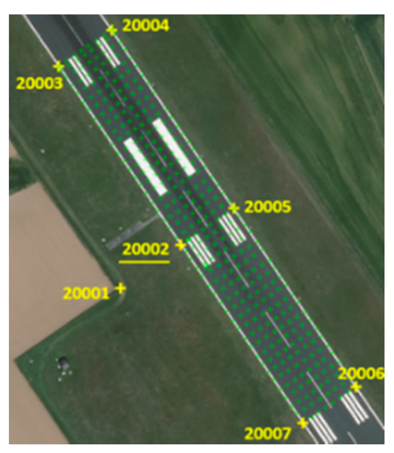
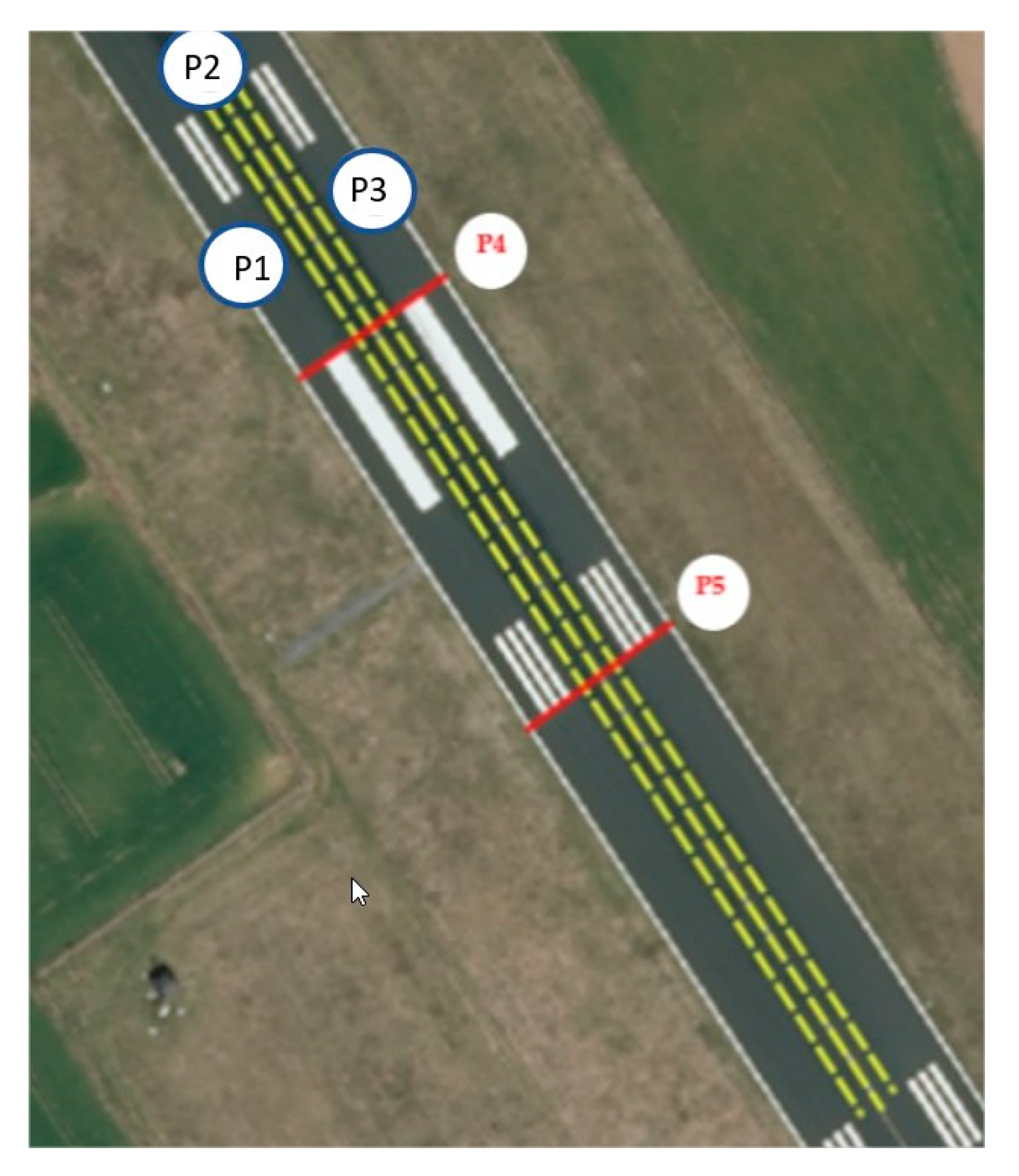
A common TIN algorithm is Delaunay triangulation [58]. It attempts to generate a surface formed by triangles of the nearest points. To do this, circles are created around selected sample points and their intersections are connected to form a network of triangles that do not overlap and are as compact as possible [54].
Besides the formation criteria of Delaunay triangulation TIN (empty circle principle), there are many other criteria, e.g., local equiangularity (max–min angle principle), minimization of the interior angle range, minimum–sum–distance principle, minimum circumscribing circle radius, and others.
The main disadvantage of TIN interpolation is that the surfaces are not smooth and can have a jagged appearance. This is caused by discontinuous slopes at the triangle edges and sample data points. In addition, triangulation is generally not suitable for extrapolation beyond the area with sampled sample data points. Interpolation methods are part of many GIS applications. Linear interpolation (TIN1) and Clough–Tocher (cubic) interpolation (TIN2) have been evaluated as useful [59].

3. Experiment

Conducting such an experiment at an airport is challenging due to strict regulations. In agreement with the airport operator, the field research (measurement of runway evenness and deformations) was conducted at Maribor Edvard Rusjan Airport, which is a public international airport and the second largest in Slovenia with reference code 4D. The runway is 2500 m long and 45 m wide and has a bearing capacity of PCN 86/F/A/X/T.
The geodetic network had to be defined in such a way that it would be stable over a long period of time and would allow optimal execution and repetition of multiple measurements. The runway is an area with a simple relief structure where there are no physical obstacles; therefore, the choice of point locations for establishing the geodetic (zero) network was not challenging. The positions of the points were chosen at the edge of the survey area where stabilization of the points on the asphalt surface was possible. This ensured the permanent and physical stability of the network over a longer period of time. Seven points—20,001, 20,002, 20,003, 20,004, 20,005, 20,006, and 20,007—were permanently stabilized around the measurement area and connected to the geodetic (zero) network (Figure 1). The stabilized points of the geodetic (zero) network formed the local coordinate system, which served as the geodetic basis for determining the location of the vertical deviations. The network created from these points was used for the planar analysis and defined the study area of the existing runway of 300 m length and 45 m width [52,53].
The various modelling procedures considered are based on one of several measurements made of the evenness of the portion of the runway under consideration. The measurement has a total of 6618 measured and calibrated points and is shown in Figure 2. For all measured points, information on the x and y geodetic coordinates and elevation at the measurement point (h = z geodetic coordinate) were included in the geodetic accuracy [51,56].
All models considered were created at a resolution of 2650 × 1920, the pixel size was 0.1 × 0.1 m, which means that the modelling was performed for a minimum runway area of 1 dm2. The latter is considered to be sufficient accuracy for the needs of sustainable runway maintenance.
In the area of the experiment determined by the geodetic base network (zero), five cross sections were defined: three longitudinal sections (P1, P2, and P3) represent the areas of expected largest runway irregularities (P1 and P3 to the left and right of the runway centerline, P2 in the middle of the runway) and two cross-sections (P4 and P5) (see Figure 3).
All analyses were performed at the same resolution and with the application Quantum GIS (QGIS v 3.16.7-Hannover) and personal computer (processor: Intel Core i7-8700CPU @ 3.20GHz, x64, RAM: 16GB). Selected analyses were performed using MatLab and MS Excel.
The different runway evenness modelling methods were compared in terms of processing time required to perform the analysis (average time of 10 trials), file size (average file size after 10 trials), and content usability of each model.

4. Results

4.1. Approximation with Regression Plane

The calculations shown were performed with our own application using the MatLab software environment. The results of the analysis are shown in Table 1.
The elevation of any point determined by the known geographic x and y coordinates is calculated using the regression plane equation shown in Table 1. The result is a continuous regression plane determined based on the least squares deviations of a large number of measured points.

4.2. Inverse Distance Weighted Interpolation (IDW)

The results of the interpolation performed are shown in Figure 4 and in Table 2. The planes shown in Figure 4 have isohypses with an equidistance spacing of 100 mm so that elevation changes on a relatively flat surface can be seen more clearly.
The algorithm used performs the interpolation on the entire rectangular area where the area of the experiment is located and not only in the area of the experiment. The interpolated plane is valid only in the area of the experiment. As a result, the processor times and sizes of the output tag image file (TIF) files are relatively large.
All three treated models were further studied using longitudinal and cross sections.
From Figure 5, it is clear that the use of the IDW1 and IDW3 methods (p = 2 and p = 10) gives similar modelling results. The IDW2 method (p = 1) gives a much flatter longitudinal slope that does not reflect the actual situation on the ground. Irregularities in the longitudinal slope at the end of the longitudinal section are due to the lack of measured data in this area (measurements were not performed to test the influence of missing data in single, selected areas). Cyclic irregularities of the longitudinal section P2 were due to the method itself, depending on the distance to the measurement point. Based on the above, it was assessed that the interpolation method IDW2 (p = 1) is not suitable for the modelling of longitudinal sections and thus for the modelling of runway evenness and was excluded from further consideration.

4.3. Interpolation Based on Triangulated Irregular Network (TIN)

The results of the performed interpolation are shown in Figure 6 and in Table 3.
Figure 7 shows a longitudinal section P3 modelled with a linear and cubic model TIN. It can be seen that the results of modelling with the linear and cubic models are completely different. While the model with linear TIN interpolation provided the expected modelling result, the cubic Clough–Tocher model provided completely unexpected modelling results that cannot be fully explained logically. We estimate that the cubic Clough–Tocher model is not suitable for surface models from a set of successive measurements, as is the case in our experiment. More useful results would be expected if the measurement data were available in a uniform network. Since this is not the case, it is estimated that the cubic Clough–Tocher interpolation is not suitable for runway modelling when the evenness data are collected in the manner presented in the experiment.

5. Discussion

The obtained results show the comparability of all described methods for modelling the evenness of runways. Different models, already presented, were used based on the same measurements. The results are presented in the form of longitudinal and cross sections of the analyzed runway and can be seen in the following graphs. The comparison of modelling of longitudinal cross sections P1, P2, and P3 is presented in Figure 8 and the comparison of modelling of cross sections P4 and P5 is presented in Figure 9. The modelling methods used are those that have proven useful in research.
The cross sections presented in Figure 8 and Figure 9 were created using the above modelling methods. In the intermediate area, where no measurements were made, the elevation values were estimated. Figure 8 clearly shows the influence of the different interpolation methods, especially in the area where no measurements were made (from the edge of the runway to the area where measurements were made). While the regression plane approximation yields a continuous plane that is clearly and demonstrably valid over the entire bounded area of the analyzed runway (line marked with an orange lock (RR) in Figure 8), the accuracy of the IDW methods outside the measurement area is questionable. The accuracy of the IDW methods within the considered cross sections (lines marked in red and green in Figure 9) (IDW1 and IDW3) depends on the distance to the measured points. TIN1 (the line marked in blue in Figure 9) is determined only within the area where measurements were performed.
From the presented longitudinal and cross sections, it can be seen that among the presented methods for modelling the evenness of airport runways, the methods of modelling with linear interpolation based on the triangulated irregular network (TIN1) and approximation with the regression plane (RR) have a useful value.
It should be emphasized that modelling is a process of converting the results of individual measurements into a plane shape. The resulting planes are a better or worse representation of the actual condition of the runway. To claim that one method of modelling is better than another is not professionally correct. Modelling results can only be more or less useful.
To answer the question of the similarity of the results obtained by each method, we compared the results obtained with the average linear slope of each cross section considered. The average linear slope was determined by the average of the modelled values (according to the considered models) at the beginning and at the end of the considered cross-section. The descriptive statistics of the absolute deviation of the modelling results from the average linear slope are presented in Table 4 and Table 5. The largest detected values are highlighted in “bold”.
Descriptive statistic (shown in Table 5) taken into consideration only the part of cross-sections where all models were defined (from 11 to 34 m).
With the descriptive statistics for all considered cross-sections, we can confirm that all considered methods of pavement evenness modelling are similar to each other and a greater utility can be attributed to the interpolation methods based on the linear triangular irregular network (TIN) and the regression plane approximation (RR). A substantial comparison of the two proposed methods shows that:
  • regression plane approximation (RR): The method allows for the calculation of the elevation of each selected point of the regression plane. Since the regression plane is continuous, the alignments of the measured runway irregularities are likely to be large. Comparison with the average linear slope shows the best fit (MAX < 3 mm, Mean < 7 mm, SE < 0,1mm on longitudinal cross-sections and MAX < 9 mm, Mean < 5 mm, SE < 3 mm on other selected cross-sections). An additional disadvantage of this method is the longer post-processing (a few hours) and, of course, the processing of the results with the MatLab program, which is not public, but was made for the purposes of this research.
  • linear triangular irregular network interpolation (TIN): A method of creating an elevation model using TIN interpolation is a tool included in every major GIS (public tool). The basic elements of the model are flat triangular surfaces whose nodes are determined by the measured elevation points. The use of the model, therefore, promotes the consideration that the model accounts as much as possible for the measured irregularities in slope evenness and most likely approximates the actual slope condition. Comparison with the average linear slope shows the good fit (MAX < 30 mm, Mean < 5 mm, SE < 0.1 mm on longitudinal cross-sections and MAX < 100 mm, Mean < 4 mm, SE < 3 mm on other selected cross-sections). The creation of a model is relatively fast and simple; the understanding of the results is guaranteed. All tools for further processing TIN are publicly available.
From the comparison of the described methods, it can be concluded that all mentioned methods (except TIN2) can be suitable for modelling the slope evenness. The greater utility compared to the other methods can be attributed mainly to TIN1 in terms of dissemination, simplicity, and comprehensibility. Continuing our research, we will focus on measuring and determining the parameters of evenness for the needs of sustainable maintenance of airport runways using other methods, trying to find the method that provides the most favorable results. The proposed method should be suitable for smaller and less frequented airports.

6. Conclusions

Airport runways are subject to internal and external forces at all times and, therefore, require regular maintenance. Maintenance involves not only inspecting the runway, but also detecting irregularities that may jeopardize the safety of flight operations. In order to determine the most beneficial way of modelling runway evenness, we have included an element of research on modelling procedures in the existing research on determining the method of conducting evenness measurements and defining the runway maintenance process. In this part, we also intend to answer the question of the applicability of the newly developed method of regression plane approximation.
In this paper, the use of three different groups of methods to model runway evenness is described and tested. It has been shown that certain methods are more useful than others. Each method has its advantages and disadvantages. Based on the research conducted, it can be concluded that the linear triangular irregular network interpolation provides the most useful results. The result of the analysis can be easily understood. Besides, there are many additional GIS tools to answer different spatial questions. We propose that the most appropriate runway evenness modelling method be incorporated into runway management systems at smaller airports.
As it was said in the introduction, the realized measurement method is proposed for smaller airports, such as Maribor Airport. The measurement was performed in a time window of 2 h, which is feasible at smaller airports without disturbing the airport schedule. The measurement method lets one perform measurements with geodetic accuracy. The latter is also of great importance for the modelling of the evenness. The application of selected methods for modelling the evenness of the runway Edvard Rusjan Airport in Maribor showed that the considered part of the runway in the length of 300 m has an average longitudinal slope of 2‰ and an average transverse slope of 8‰. This is in accordance with standard runway construction rules. Additional spatial analysis (isohypses with an equidistance spacing of 1 mm) showed that there are no irregularities in the considered part of the runway where water could be retained and jeopardize the safety of the airport.
In the continuation of our research, we will also look into the application and comparison of other methods (such as the InSar method) to determine the irregularities of airport runways. The InSar method described in [16] is used to determine deformations at Rome airport with millimeter accuracy.
In the research, we came to the realization that all the methods described in our research are suitable for modelling irregularities. Among the methods, the TIN2 method, which is time-consuming and has the most scattered results, proved to be the worst method. Among the most useful methods has been the TIN1 method, which has the advantage mainly in terms of dissemination, simplicity, and comprehensibility. All of the described methods require only a short-term closure of the airport, which does not pose an economic and logistic problem in terms of bridging the traffic.
The analyzed methods are applied to the needs of runway condition analysis within the processes of sustainable runway maintenance, allowing timely intervention and thus maintaining the quality and usable condition of runways throughout their life cycle. In future research, we will try to connect our results with the results of other methods, especially the InSAR method.

Author Contributions

Conceptualization, D.S., D.D. and B.K.; methodology, D.S.; software, D.S. and D.D.; validation, D.S., D.D. and B.K.; formal analysis, B.K.; investigation, D.S and D.D.; resources, D.S.; data curation, B.K.; writing—original draft preparation, D.S. and B.K.; writing—review and editing, D.S. and B.K.; visualization, D.S., D.D. and B.K.; supervision, B.K.; project administration, D.D. All authors have read and agreed to the published version of the manuscript.

Funding

This research received no external funding.

Institutional Review Board Statement

Not applicable.

Informed Consent Statement

Informed consent was obtained from all subjects involved in the study.

Data Availability Statement

The data presented in this study are available on request from the corresponding author. The data are not publicly available. The data were obtained on the basis of own research within the doctoral dissertation of Dr. Damjan Doler at the Faculty of Logistics, University of Maribor.

Acknowledgments

The authors of the article thank the staff of Edvard Rusjan Airportand where field experiment was perform and of Faculty of Logistics, University of Maribor.

Conflicts of Interest

The authors declare no conflict of interest.

References

  1. Jackson, P.T.G.; Nelson, C.J.; Schiefele, J.; Obara, B. Runway detection in High Resolution remote sensing data. In Proceedings of the 9th International Symposium on Image and Signal Processing and Analysis (ISPA), Zagreb, Croatia, 7–9 September 2015. [Google Scholar]
  2. Lee, M.-H.; Chou, C.-P.; Li, K.-H. Automatic measurement of runway grooving construction for pavement skid evaluation. Autom. Constr. 2009, 18, 856–863. [Google Scholar] [CrossRef]
  3. Moon, S.; Yang, B.; Kim, J.; Seo, J. Effectiveness of remote control for a concrete surface grinding machine. Autom. Constr. 2010, 19, 734–741. [Google Scholar] [CrossRef]
  4. Taleghani, M.; Taleghani, A. Hierachy of Sustainablility Management System. Available online: https://www.researchgate.net/publication/343548430_Hierarchy-of-Sustainability-Management-System (accessed on 17 March 2021).
  5. Choi, T.-M.; Chiu, C.H.; Chan, H.K. Risk management of logistics systems. Transp. Res. Part E Logist. Transp. Rev. 2016, 90, 1–6. [Google Scholar] [CrossRef]
  6. Bensassi, S.; Márquez-Ramos, L.; Martinez-Zarzoso, I.; Suárez-Burguet, C. Relationship between logistics infrastructure and trade: Evidence from Spanish regional exports. Transp. Res. Part A Policy Pract. 2015, 72, 47–61. [Google Scholar] [CrossRef]
  7. Tsai, M.-C.; Su, Y.-S. Political risk assessment on air logistics hub developments in Taiwan. J. Air Transp. Manag. 2002, 8, 373–380. [Google Scholar] [CrossRef]
  8. ICAO. Aerodrome Design Manual, Part 1 Runway, 4th ed.; ICAO: Montreal, QC, Canada, 2020. [Google Scholar]
  9. Micco, A.; Serebrisky, T. Infrastructure, Competition Regimes, and Air Transport Costs: Cross-Country Evidence; Policy Research Working Paper Series 3355; World Bank: Washington, DC, USA, 2004. [Google Scholar]
  10. Bogoyavlenskiy, A. The analysis of measurements of flatness of the artificial surfaces of the runway of civil aerodrome. World Meas. 2018. [Google Scholar] [CrossRef]
  11. Barbarella, M.; De Blasiis, M.R.; Fiani, M.; Santoni, M. A LiDAR application for the study of taxiway surface evenness and slope. ISPRS Ann. Photogramm. Remote. Sens. Spat. Inf. Sci. 2014, II-5, 65–72. [Google Scholar] [CrossRef] [Green Version]
  12. Schwarz, K.P.; El-Sheimy, N. Mobile Mapping Systems—State of The Art and Future Trends. Int. Arch. Photogramm. Remote Sens. Spat. Inf. Sci. 2004, 35, 10. [Google Scholar]
  13. Samsonov, S.V.; D’Oreye, N.; Gonzalez, P.J.; Tiampo, K.; Ertolahti, L.; Clague, J.J. Rapidly accelerating subsidence in the Greater Vancouver region from two decades of ERS-ENVISAT-RADARSAT-2 DInSAR measurements. Remote. Sens. Environ. 2014, 143, 180–191. [Google Scholar] [CrossRef] [Green Version]
  14. Mao, X.; Yuan, C.; Gan, J. Incorporating Dynamic Traffic Distribution into Pavement Maintenance Optimization Model. Sustainability 2019, 11, 2488. [Google Scholar] [CrossRef] [Green Version]
  15. Kelemen, M.; Polishchuk, V.; Gavurová, B.; Andoga, R.; Szabo, S.; Yang, W.; Christodoulakis, J.; Gera, M.; Kozuba, J.; Kaľavský, P.; et al. Educational Model for Evaluation of Airport NIS Security for Safe and Sustainable Air Transport. Sustainability 2020, 12, 6352. [Google Scholar] [CrossRef]
  16. Ciampoli, L.B.; Gagliardi, V.; Ferrante, C.; Calvi, A.; D’Amico, F.; Tosti, F. Displacement Monitoring in Airport Runways by Persistent Scatterers SAR Interferometry. Remote Sens. 2020, 12, 3564. [Google Scholar] [CrossRef]
  17. Ding, W.; Wu, J. An Airport Knowledge-Based Method for Accurate Change Analysis of Airport Runways in VHR Remote Sensing Images. Remote Sens. 2020, 12, 3163. [Google Scholar] [CrossRef]
  18. Brtnický, M.; Pecina, V.; Baltazár, T.; Vašinová Galiová, M.; Baláková, L.; Bęś, A.; Radziemska, M. Environmental Impact Assessment of Potentially Toxic Elements in Soils Near the Runway at the International Airport in Central Europe. Sustainability 2020, 12, 7224. [Google Scholar] [CrossRef]
  19. Svigkas, N.; Loupasakis, C.; Papoutsis, I.; Kontoes, C.; Alatza, S.; Tzampoglou, P.; Tolomei, C.; Spachos, T. InSAR Campaign Reveals Ongoing Displacement Trends at High Impact Sites of Thessaloniki and Chalkidiki, Greece. Remote Sens. 2020, 12, 2396. [Google Scholar] [CrossRef]
  20. Cai, Y.; Ma, J.; Yan, W.; Zhang, W.; An, Y. Aircraft Detection Using Phase-Sensitive Optical-Fiber OTDR. Sensors 2021, 21, 5094. [Google Scholar] [CrossRef]
  21. Wesolowski, M.; Iwanowski, P. Evaluation of Natural Airfield Pavements Condition Based on the Airfield Pavement Condition Index (APCI). Appl. Sci. 2021, 11, 6139. [Google Scholar] [CrossRef]
  22. Baldo, N.; Miani, M.; Rondinella, F.; Celauro, C. A Machine Learning Approach to Determine Airport Asphalt Concrete Layer Moduli Using Heavy Weight Deflectometer Data. Sustainability 2021, 13, 8831. [Google Scholar] [CrossRef]
  23. Zhao, G.; Wang, L.; Deng, K.; Wang, M.; Xu, Y.; Zheng, M.; Luo, Q. An Adaptive Offset-Tracking Method Based on Deformation Gradients and Image Noises for Mining Deformation Monitoring. Remote Sens. 2021, 13, 2958. [Google Scholar] [CrossRef]
  24. Dai, K.; Shi, X.; Gou, J.; Hu, L.; Chen, M.; Zhao, L.; Dong, X.; Li, Z. Diagnosing Subsidence Geohazard at Beijing Capital International Airport, from High-Resolution SAR Interferometry. Sustainability 2020, 12, 2269. [Google Scholar] [CrossRef] [Green Version]
  25. Chen, Y.-H.; Chou, C.-P. Effects of Airport Pavement-Profile Wavelength on Aircraft Vertical Responses. Transp. Res. Rec. J. Transp. Res. Board 2004, 1889, 83–93. [Google Scholar] [CrossRef]
  26. Šoštarić, M.; Vidović, K.; Jakovljević, M.; Lale, O. Data-Driven Methodology for Sustainable Urban Mobility Assessment and Improvement. Sustainability 2021, 13, 7162. [Google Scholar] [CrossRef]
  27. Pittenger, D.M. Evaluating Sustainability of Selected Airport Pavement Treatments with Life-Cycle Cost, Raw Material Consumption, and Greenroads Standards. Transp. Res. Rec. J. Transp. Res. Board 2011, 2206, 61–68. [Google Scholar] [CrossRef]
  28. Di Mascio, P.; Moretti, L. Implementation of a pavement management system for maintenance and rehabilitation of airport surfaces. Case Stud. Constr. Mater. 2019, 11, e00251. [Google Scholar] [CrossRef]
  29. De Luca, M.; Dell’Acqua, G. Runway surface friction characteristics assessment for Lamezia Terme airfield pavement management system. J. Air Transp. Manag. 2014, 34, 1–5. [Google Scholar] [CrossRef]
  30. Ghosh, R.; Schilling, T.; Wicke, K. Theoretical framework of systems design for the air transportation system including an inherently quantitative philosophy of scenario development. J. Air Transp. Manag. 2017, 58, 58–67. [Google Scholar] [CrossRef] [Green Version]
  31. Gendreau, M.; Soriano, P. Airport pavement management systems: An appraisal of existing methodologies. Transp. Res. Part A: Policy Pract. 1998, 32, 197–214. [Google Scholar] [CrossRef]
  32. D’Apuzzo, M.; Festa, B.; Giuliana, G.; Mancini, L.; Nicolosi, V. The Evaluation of Runway Surface Properties: A New Approach. Proc. Soc. Behav. Sci. 2012, 53, 1192–1201. [Google Scholar] [CrossRef]
  33. Đapo, A. Obrada i Intrepretacija Geodetskih mjerenja na Geodinamičkoj mreži Grada Zagreba. Master’s Thesis, University of Zagreb, Zagreb, Croatia, 2005. [Google Scholar]
  34. Ferretti, A.; Prati, C.; Rocca, F. Permanent scatterers in SAR interferometry. IEEE Trans. Geosci. Remote. Sens. 2001, 39, 8–20. [Google Scholar] [CrossRef]
  35. Pribičević, B.; Medak, D.; Đapo, A. Densification of the Zagreb Geodynamic Network in the area of northeast Medvednica. Geod. List 2007, 61, 247–258. [Google Scholar]
  36. Mileusnic, M.; Parlov, J.; Bacani, A.; Durn, G. Conceptual model for groundwater status and risk assessment—Case study of the Zagreb aquifer system. Geol. Croat. 2013, 66, 55–76. [Google Scholar]
  37. Osmanoğlu, B.; Sunar, F.; Wdowinski, S.; Cabral-Cano, E. Time series analysis of InSAR data: Methods and trends. ISPRS J. Photogramm. Remote. Sens. 2016, 115, 90–102. [Google Scholar] [CrossRef]
  38. Wang, W. Protocol Based Pavement Cracking Measurement with 1 mm 3D Pavement Surface Model. Ph.D. Thesis, Oklahoma State University, Stillwater, OK, USA, 2015. [Google Scholar]
  39. Kamath, V.R.; Martinez, J.C. Generic representation of 3D motion paths in dynamic animations of simulated construction processes. Autom. Constr. 2008, 17, 188–200. [Google Scholar] [CrossRef]
  40. Khoemarga, K.V.; Tajudin, A.N. Structural design of Airport runway Case study: Jos Orno Imsula MOA Airport; Conference Series Materials Science and Engineering, 852. In Proceedings of the 2nd Tarumanagara International Conference on the Applications of Technology and Engineering (TICATE), Jakarta, Indonesia, 21–22 November 2019. [Google Scholar]
  41. Becek, K.; Koppe, W.; Kutoğlu, H. Evaluation of Vertical Accuracy of the WorldDEMTM Using the Runway Method. Remote. Sens. 2016, 8, 934. [Google Scholar] [CrossRef] [Green Version]
  42. Oliveira, H.; Correia, P.L. Automatic Road Crack Detection and Characterization. IEEE Trans. Intell. Transp. Syst. 2013, 14, 155–168. [Google Scholar] [CrossRef]
  43. Mokhtari, S.; Wu, L.; Yun, H.-B. Comparison of Supervised Classification Techniques for Vision-Based Pavement Crack Detection. Transp. Res. Rec. J. Transp. Res. Board 2016, 2595, 119–127. [Google Scholar] [CrossRef]
  44. Shi, Y.; Cui, L.; Qi, Z.; Meng, F.; Chen, Z. Automatic Road Crack Detection Using Random Structured Forests. IEEE Trans. Intell. Transp. Syst. 2016, 17, 3434–3445. [Google Scholar] [CrossRef]
  45. Wang, P.; Hu, Y.; Dai, Y.; Tian, M. Asphalt Pavement Pothole Detection and Segmentation Based on Wavelet Energy Field. Math. Probl. Eng. 2017, 2017, 1604130. [Google Scholar] [CrossRef] [Green Version]
  46. Peng, L.; Chao, W.; Shuangmiao, L.; Baocai, F. Research on Crack Detection Method of Airport Runway Based on Twice-Threshold Segmentation. In Proceedings of the 5th International Conference on Instrumentation and Measurement, Computer, Communication and Control (IMCCC), Harbin, China, 18–20 September 2015. [Google Scholar]
  47. Fernández, A.C.; Rodríguez-Lozano, F.J.; Villatoro, R.; Olivares, J.; Palomares, J.M. Efficient pavement crack detection and classification. EURASIP J. Image Video Process. 2017, 2017, 39. [Google Scholar] [CrossRef]
  48. He, L.; Lin, H.; Zou, Q.; Zhang, D. Accurate measurement of pavement deflection velocity under dynamic loads. Autom. Constr. 2017, 83, 149–162. [Google Scholar] [CrossRef]
  49. Li, W.; Huyan, J.; Tighe, S.L.; Ren, Q.-Q.; Sun, Z.-Y. Three-Dimensional Pavement Crack Detection Algorithm Based on Two-Dimensional Empirical Mode Decomposition. J. Transp. Eng. Part B Pavements 2017, 143, 04017005. [Google Scholar] [CrossRef]
  50. De Souza, N.M.; Filha, A.T.A. A systematic airport runway maintenance and inspection policy based on a delay time modelling approach. Autom. Constr. 2020, 110, 103039. [Google Scholar] [CrossRef]
  51. Kovačič, B.; Doler, D.; Sever, D. Innovative Business Model for the Management of Airports in Purpose to Identify Runway Damage in Time. Sustainability 2021, 13, 613. [Google Scholar] [CrossRef]
  52. Kovačič, B.; Doler, D.; Sever, D. The Innovative Model of Runway Sustainable Management on Smaller Regional Airports. Sustainability 2021, 13, 652. [Google Scholar] [CrossRef]
  53. Kovačič, B.; Želodec, D.; Doler, D. Prototype of the Runway Monitoring Process at Smaller Airports: Edvard Rusjan Airport Maribor. Processes 2020, 8, 1689. [Google Scholar] [CrossRef]
  54. Mitas, L.; Mitasova, H. Spatial Interpolation. In Geographic Information Systems: Principles, Techniques, Management and Applications, 2nd ed.; Longley, P.A., Goodchild, M.F., Maguire, D.J., Rhind, D.W., Eds.; Wiley: Hoboken, NJ, USA, 2005; Volume 1, Part 2, Chapter 34; ISBN 978-0-471-73545-8. [Google Scholar]
  55. Penrose, R.A. Generalized inverse for matrices. Proc. Camb. Philos. Soc. 1955, 51, 406–413. [Google Scholar] [CrossRef] [Green Version]
  56. Doler, D. Inoviran Model Kontinuiranega Spremljanja Deformacij Letaliških Vzletno Pristajalnih Stez. Ph.D. Thesis, Univerza v Mariboru, Maribor, Slovenia, 2020. [Google Scholar]
  57. Achilleos, G. The Inverse Distance Weighted interpolation method and error propagation mechanism—Creating a DEM from an analogue topographical map. J. Spat. Sci. 2011, 56, 283–304. [Google Scholar] [CrossRef]
  58. Delaunay, B. Sur la sphère vide. Izv. Akad. Nauk SSSR Otd. Mat. i Estestv. Nauk 1934, 7, 1–2. [Google Scholar]
  59. Mann, S. Cubic Precision Clough-Tocher Interpolation; Computer Science Department of University of Waterloo: Waterloo, ON, Canada, 1998; Report CS-98-15. [Google Scholar]
Figure 1. Basic (zero) geodetic network (yellow points) and NETWORK on the runway (green points) [56].
Applsci 11 08697 g001
Figure 2. Measured data set.
Applsci 11 08697 g002
Figure 3. Scope of the experiment and sections considered.
Applsci 11 08697 g003
Figure 4. Results of IDW interpolation.
Applsci 11 08697 g004
Figure 5. Modelling of the longitudinal cross section P2 using selected IWD methods.
Applsci 11 08697 g005
Figure 6. Results of TIN interpolation.
Applsci 11 08697 g006
Figure 7. Modelling of the longitudinal section P3 using TIN interpolation methods.
Applsci 11 08697 g007
Figure 8. Runway modelling in longitudinal cross-section P1, P2, and P3 by selected models.
Applsci 11 08697 g008
Figure 9. Runway modelling in cross section P4 and P5 by selected models.
Applsci 11 08697 g009
Table 1. Regression plane parameters [m] for the selected case.
Regression Plane ParametersabcD
R3−0.0112926570−0.005096983517,265.5263
Parameter accuracy σ a σ b σ c σ D
R31.5154 × 10−51.1416 × 10−511
Table 2. Results of IDW interpolation.
No.CasepAverage Computer Time (s)Range of File (MB)Comment
1IDW12170549.139Expected and sensible solution
2IDW21406.949.138p = 1 => inappropriate parameter. The results are not within expectations.
3IDW3101697.0149.061Expected and sensible solution
Table 3. Results of TIN interpolation.
No.CasepAverage Computer Time (s)Range of File (MB)Comment
1TIN1linear1.4333.679Expected and sensible solution
2TIN2cubic1.7630.314Comprehensibility of the model is not guarantee
Table 4. Descriptive statistics of absolute deviation of considered models (cross-sections P1, P2, and P3) from the average linear slope.
Cross-SectionModels [‰]Descriptive Statistics [m]
Mean MedianSESDV (m2]Max
P1
S = 2.18‰
IDW12.180.015090.014930.000220.007880.000060.03197
IDW32.230.009410.009280.000150.005430.000020.02732
TIN12.180.004120.003450.000090.003140.000010.01339
RR2.140.004280.003590.000080.003020.000010.01019
P2 *
S = 2.06‰
IDW12.170.003760.002640.000110.003560.000010.02257
IDW32.190.007740.007910.000130.004350.000010.01959
TIN12.180.004310.004150.000070.002690.000010.01440
RR2.140.001640.001640.000010.000550.000010.00260
P3 **
S = 2.18‰
IDW12.160.007610.007320.000140.004580.000020.01795
IDW32.210.009090.008170.000180.006030.000030.02126
TIN12.210.004550.003890.000090.003360.000010.02291
RR2.170.001110.000910.000020.00078<0.000010.00266
Where is: S … slope of average linear cross-section. s … slope of cross section modelled by individual model. SE … standard error of modelled deviations. SD … standard deviation. V … variance of modelled deviations. Max … maximal deviation from average linear cross-section elevation. P2 * … the impact of lack of data is not taken into consideration (cross-section is considered up to a distance of 250 m). P3 ** … the impact of lack of data is not taken into consideration (cross-section is considered up to a distance of 260 m).
Table 5. Descriptive statistics of absolute deviation of considered models (cross-sections P4 and P5) from the average linear slope.
Cross-SectionModels [‰]Descriptive Statistics [m]
Mean MedianSESDVMax
P4
S = 8.46‰
IDW18.160.036690.034590.001370.013230.000170.09093
IDW38.740.043800.034850.003510.033890.001140.12133
TIN18.670.039060.033660.003230.031190.000970.09810
RR8.260.040320.040180.002600.025130.000630.08340
P5
S = 7.95‰
IDW17.800.042160.041660.001290.012540.000150.08801
IDW37.910.044730.039560.003070.029840.000890.11181
TIN17.890.042290.040820.002630.025560.000650.09024
RR8.190.041230.040400.002830.027500.000750.08936
Publisher’s Note: MDPI stays neutral with regard to jurisdictional claims in published maps and institutional affiliations.

