
A Practical Method for the Automatic Recognition of Rock Structures in Panoramic Borehole Image during Deep-Hole Drilling Engineering


Abstract
:Featured Application
Abstract
1. Introduction
2. Application of Borehole Camera Technology in Engineering
2.1. Digital Panoramic Borehole Camera System (DPBCS)
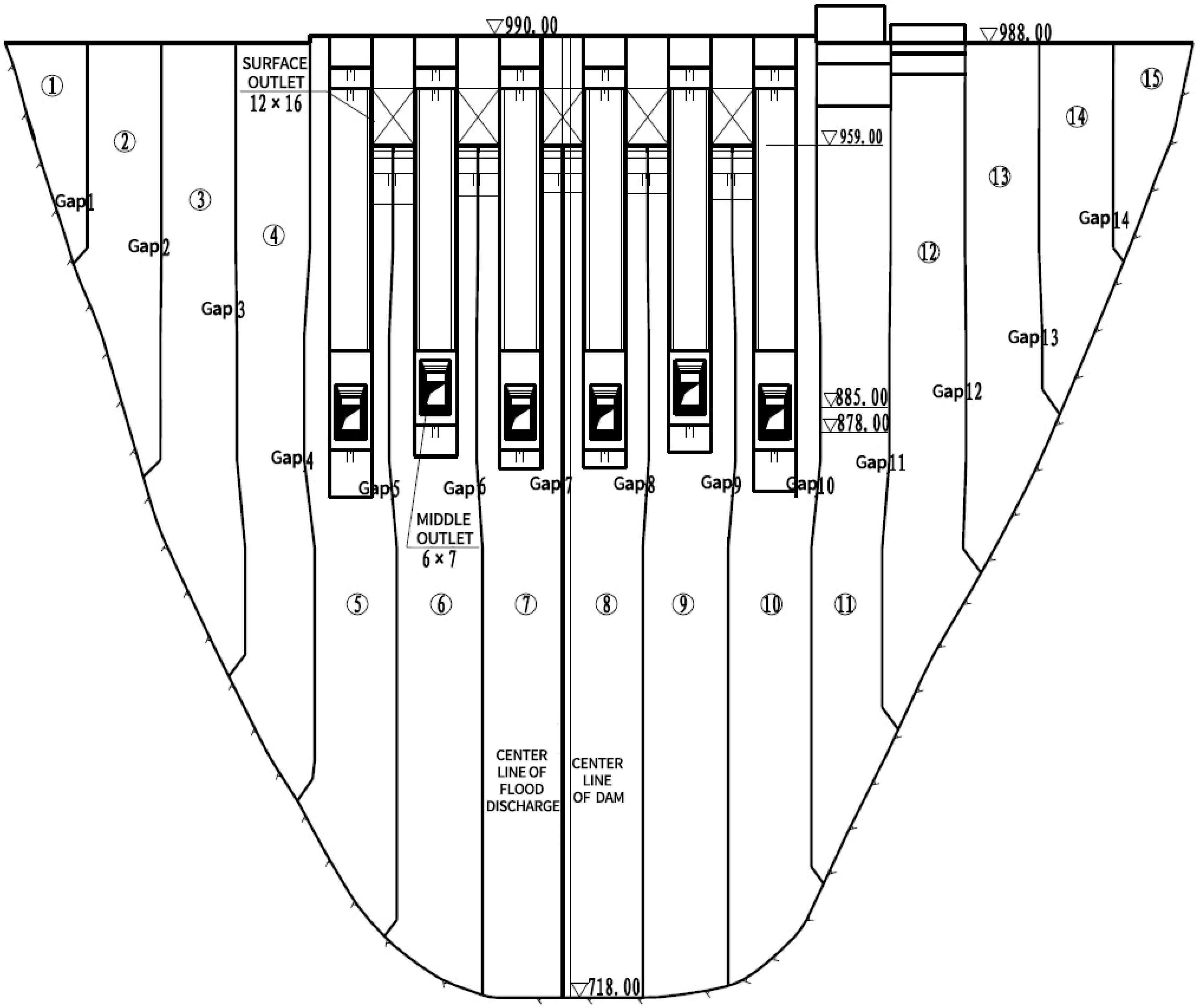
2.2. Boreholes and Image Characteristics of Wudongde Hydropower Station
3. The Practical Method of Automatic Recognition for Rock Structures
3.1. Structural Plane Area Division Based on Cluster Projection
3.2. Feature Matching of Structural Planes Based on the Sine Function
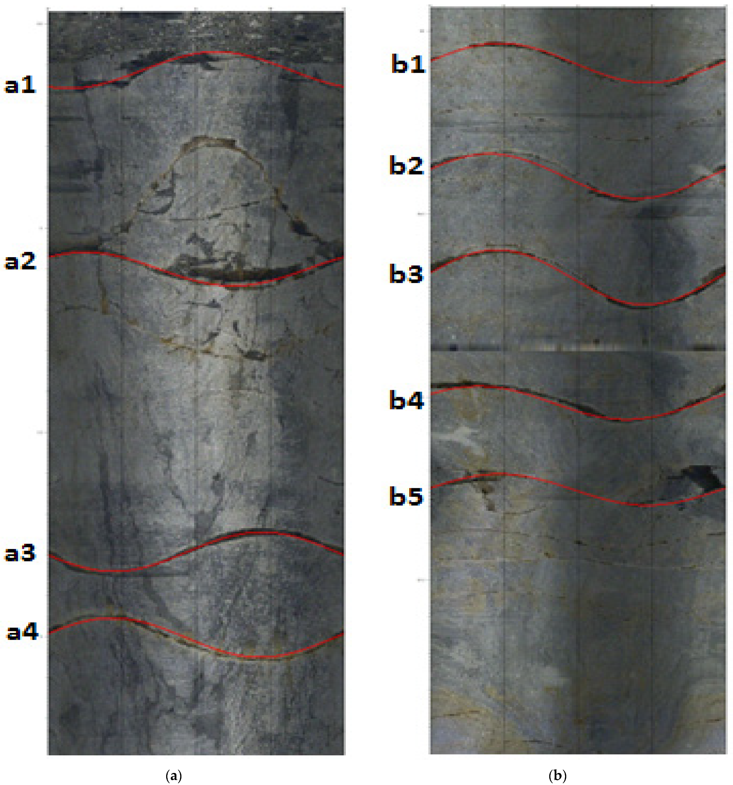
4. Application Results and Discussion
5. Conclusions
- (1)
- In practical engineering, the automatic recognition method based on cluster projection and feature function matching can automatically identify the structural planes in a full-hole panoramic borehole image. Furthermore, it can extract the position, dip, dip direction, and gap of structural planes, and perform annotation and statistical analysis.
- (2)
- When used on the panoramic borehole images from Wudongde Hydropower Station, the recognition rate of this automatic recognition method was approximately 90.3%, the accuracy rate was approximately 88.5%, and the average deviation of the parameters of the accurate recognition results was approximately 3.2%. Thus, the efficiency was much greater compared to manual interpretation.
- (3)
- The application of automatic recognition technology to panoramic borehole images in engineering practice greatly improved efficiency. The working time was reduced from the original seven days to about four h, which shortened the engineering time cost and provided a timely and effective data analysis result. The technology also contributes to the further intellectualization of borehole imaging.
- (4)
- In complex or poorly imaged structural surface areas, especially in the crushing zone of a rock mass, the automatic recognition method inevitably returns some erroneous or inaccurate recognition results. In order to ensure the quality of the practical project and the authenticity and reliability of the structural plane data, it is recommended to use the automatic identification method to reach a preliminary result, and then use the fine identification method and manual interpretation to identify the structural plane data compared to the original panoramic borehole images. If necessary, the data can be manually modified to ensure the authenticity of the final structural plane data.
Author Contributions
Funding
Institutional Review Board Statement
Informed Consent Statement
Data Availability Statement
Acknowledgments
Conflicts of Interest
References
- Lan, H.; Ian, D.M. Experimental Investigation Examining Influence of Burial Depth on Stability of Horizontal Boreholes in Sand. J. Geotech. Geoenvironmental Eng. 2020, 146, 04020013. [Google Scholar] [CrossRef]
- Zou, X.; Wang, C.; Song, H. Applications of high-resolution borehole image rapid synthesis method for the refined detection of in-suit rock mass structural features during deep-buried geotechnical engineering. Int. J. Numer. Anal. Methods Geomech. 2021. [Google Scholar] [CrossRef]
- Zangeneh, N.; Eberhardt, E.; Bustin, R.M. Investigation of the influence of natural fractures and in situ stress on hydraulic fracture propagation using a distinct-element approach. Can. Geotech. J. 2014, 52, 926–946. [Google Scholar] [CrossRef] [Green Version]
- Bae, D.S.; Kim, K.S.; Koh, Y.K.; Kim, J.Y. Characterization of Joint Roughness in Granite by Applying the Scan Circle Technique to Images from a Borehole Televiewer. Rock Mech. Rock Eng. 2011, 44, 497–504. [Google Scholar] [CrossRef]
- Williams, J.H.; Johnson, C.D. Acoustic and optical borehole-wall imaging for fractured-rock aquifer studies. J. Appl. Geophys. 2004, 55, 151–159. [Google Scholar] [CrossRef]
- Huang, C.; Chen, S. Stress Analysis of an Inclined Borehole Subjected to Fluid Discharge in Saturated Transversely Isotropic Rocks. Int. J. Geomech. 2019, 19, 04019118. [Google Scholar] [CrossRef]
- Zou, X.J.; Song, H.; Wang, C. A High-Precision Digital Panoramic Borehole Camera System for the Precise Analysis of In Situ Rock Structures. Rock Mech. Rock Eng. 2021, 1–8. Available online: http://ir.whrsm.ac.cn/handle/2S6PX9GI/27612?mode=full&submit_simple=Show+full+item+record (accessed on 2 September 2021).
- Wang, C.; Zou, X.; Han, Z.; Wang, Y.; Wang, J. An automatic recognition and parameter extraction method for structural planes in borehole image. J. Appl. Geophys. 2016, 135, 135–143. [Google Scholar] [CrossRef] [Green Version]
- Wang, C.; Zou, X.; Han, Z.; Wang, J.; Wang, Y. The automatic interpretation of structural plane parameters in borehole camera images from drilling engineering. J. Pet. Sci. Eng. 2017, 154, 417–424. [Google Scholar] [CrossRef] [Green Version]
- Cunningham, K.J.; Carlson, J.I.; Hurley, N.F. New method for quantification of vuggy porosity from digital optical borehole images as applied to the karstic Pleistocene limestone of the Biscayne aquifer, southeastern Florida. J. Appl. Geophys. 2004, 55, 77–90. [Google Scholar] [CrossRef]
- Zou, X.; Wang, C.; Wang, Y.; Song, H. Morphological Feature Description Method of Structural Surface in Borehole Image During In-Situ Instrumentation. Rock Mech. Rock Eng. 2020, 53, 2947–2956. [Google Scholar] [CrossRef]
- Zou, X.; Wang, C.; Song, H.; Han, Z.; Ma, Z. Experimental measurements of sediment incipient velocity by using B-scan ultrasound imaging device in the water channel. Measurement 2017, 98, 228–236. [Google Scholar] [CrossRef] [Green Version]
- Han, Z.; Wang, C.; Liu, S.; Zhu, H. Research on connectivity of deep ore-lodes of borehole based on digital borehole camera. Disaster Adv. 2013, 6, 41–46. [Google Scholar]
- Zou, X.; Song, H. The fast formation of high-precision panoramic image for the processing of borehole camera video of deep rock mass structures. Bull. Eng. Geol. Environ. 2021, 80, 2199–2213. [Google Scholar] [CrossRef]
- Huang, A.B.; Fang, C.K.; Liao, J.J.; Pan, Y.W. Development of a multiple-purpose borehole testing device for soft rock. Geotech. Test. J. 2002, 25, 227–233. [Google Scholar]
- Huang, X.-L.; Ma, X.; Hu, F. Editorial: Machine Learning and Intelligent Communications. Mob. Netw. Appl. 2018, 23, 68–70. [Google Scholar] [CrossRef] [Green Version]
- Thai, T.M.; Wu, W.; Hui, X. Big Data in Complex and Social Networks; Chapman and Hall/CRC Press: Boca Raton, FL, USA, 2016. [Google Scholar] [CrossRef]
- Stai, E.; Kafetzoglou, S.; Tsiropoulou, E.E.; Papavassiliou, S. A holistic approach for personalization, relevance feedback & recommendation in enriched multimedia content. Multimed. Tools Appl. 2018, 77, 283–326. [Google Scholar] [CrossRef]
- Lofi, J.; Pezard, P.; Loggia, D.; Garel, E.; Gautier, S.; Merry, C.; Bondabou, K. Geological discontinuities, main flow path and chemical alteration in a marly hill prone to slope instability: Assessment from petrophysical measurements and borehole image analysis. Hydrol. Process. 2012, 26, 2071–2084. [Google Scholar] [CrossRef]
- Schepers, R.; Rafat, G.; Gelbke, C.; Lehmann, B. Application of borehole logging, core imaging and tomography to geotechnical exploration. Int. J. Rock Mech. Min. Sci. 2001, 38, 867–876. [Google Scholar] [CrossRef]
- Dong, Y.; Wei, C.; Lu, N. Identifying Soil Adsorptive Water by Soil Water Density. J. Geotech. Geoenvironmental Eng. 2020, 146, 02820001. [Google Scholar] [CrossRef]
- Zhou, Z.; Zhao, Y.; Wang, J.; Zheng, H. A Novel Apparatus for Obtaining In Situ Estimates of Anisotropism Hydraulic Conductivity in Fractured Rocks. Geotech. Test. J. 2016, 39. [Google Scholar] [CrossRef]
- Vavro, M.; Souček, K.; Staš, L.; Waclawik, P.; Vavro, L.; Konicek, P.; Ptáček, J. Application of alternative methods for determination of rock quality designation (RQD) index: A case study from the Rožná I uranium mine, Strážek Moldanubicum, Bohemian Massif, Czech Republic. Can. Geotech. J. 2015, 52, 1466–1476. [Google Scholar] [CrossRef]
- Thapa, B.B.; Hughett, P.; Karasaki, K. Semi-automatic analysis of rock fracture orientations from borehole wall images. Geophysics 1997, 62, 129–137. [Google Scholar] [CrossRef]
- Zhang, H.; Yin, S.; Aadnoy, B.S. Finite-Element Modeling of Borehole Breakouts for In Situ Stress Determination. Int. J. Geomech. 2018, 18, 04018174. [Google Scholar] [CrossRef]
- Yan, C.; Deng, J.; Yu, B.; Li, W.; Chen, Z.; Hu, L.; Li, Y. Borehole stability in high-temperature formations. Rock Mech. Rock Eng. 2014, 47, 2199–2209. [Google Scholar] [CrossRef]
- Hurich, C.; Deemer, S. Combined surface and borehole seismic imaging in a hard rock terrain: A field test of seismic interferometry. Geophysics 2013, 78, B103–B110. [Google Scholar] [CrossRef]
- Wu, J.; Feng, S.; Li, H. Study of automatically extracting structural plane parameters from borehole images. Rock Soil Mech. 2011, 32, 951–957. [Google Scholar]
- Chai, H.; Li, N.; Xiao, C.; Liu, X.; Li, D.; Wang, C.; Wu, D. Automatic discrimination of sedimentary facies and lithologies in reef-bank reservoirs using borehole image logs. Appl. Geophys. 2009, 6, 17–29. [Google Scholar] [CrossRef]
- Assous, S.; Elkington, P.; Clark, S.; Whetton, J. Automated detection of planar geologic features in borehole images. Geophysics 2013, 79, D11–D19. [Google Scholar] [CrossRef]
- Al-Sit, W.; Al-Nuaimy, W.; Marelli, M.; Al-Ataby, A. Visual texture for automated characterisation of geological features in borehole televiewer imagery. J. Appl. Geophys. 2015, 119, 139–146. [Google Scholar] [CrossRef]
- Malone, T.; Hubbard, B.; Merton-Lyn, D.; Worthington, P.; Zwiggelaar, R. Borehole and Ice Feature Annotation Tool (BIFAT): A program for the automatic and manual annotation of glacier borehole images. Comput. Geosci. 2013, 51, 381–389. [Google Scholar] [CrossRef]
- Zou, X.; Ma, Z.; Hu, W.; Wang, J.; Song, H.; Hu, X.; Tao, W. B-mode ultrasound imaging measurement and 3D reconstruction of submerged topography in sediment-laden flow. Measurement 2015, 72, 20–31. [Google Scholar] [CrossRef]
- Zou, X.; Wang, C.; Song, H.; Han, Z.; Ma, Z.; Hu, W. Applications of ultrasound imaging system for measuring water-sand parameters during sediment transport process in hydraulic model experiments. J. Hydroinformatics 2018, 20, 410–423. [Google Scholar] [CrossRef] [Green Version]
- Zou, X.J.; Hu, W.B.; Song, H.; Chen, B.R. The Visual Measurement of Velocity Profile Distribution in Silt Carrying Flow by Using Ultrasound PIV and Iterative Multi-Grid Deformation Technique. Appl. Sci. 2021, 11, 6952. [Google Scholar] [CrossRef]
- Glossop, K.; Lisboa, P.J.; Russell, P.C.; Siddans, A.; Jones, G.R. An implementation of the Hough transformation for the identification and labelling of fixed period sinusoidal curves. Comput. Vis. Image Underst. 1999, 74, 96–100. [Google Scholar] [CrossRef]


| No. | Depth/m | Dip/° | Dip Angle/° | Gap Width/mm |
|---|---|---|---|---|
| a1 | −0.618 | 155 | 44 | 9.1 |
| a2 | −1.083 | 315 | 42 | 10.5 |
| a3 | −1.782 | 100 | 46 | 8.3 |
| a4 | −1.994 | 282 | 46 | 6.6 |
| b1 | −30.072 | 275 | 49 | 6.2 |
| b2 | −30.396 | 287 | 53 | 7.4 |
| b3 | −30.675 | 279 | 58 | 8.1 |
| b4 | −31.015 | 301 | 44 | 9.7 |
| b5 | −31.256 | 276 | 42 | 6.5 |
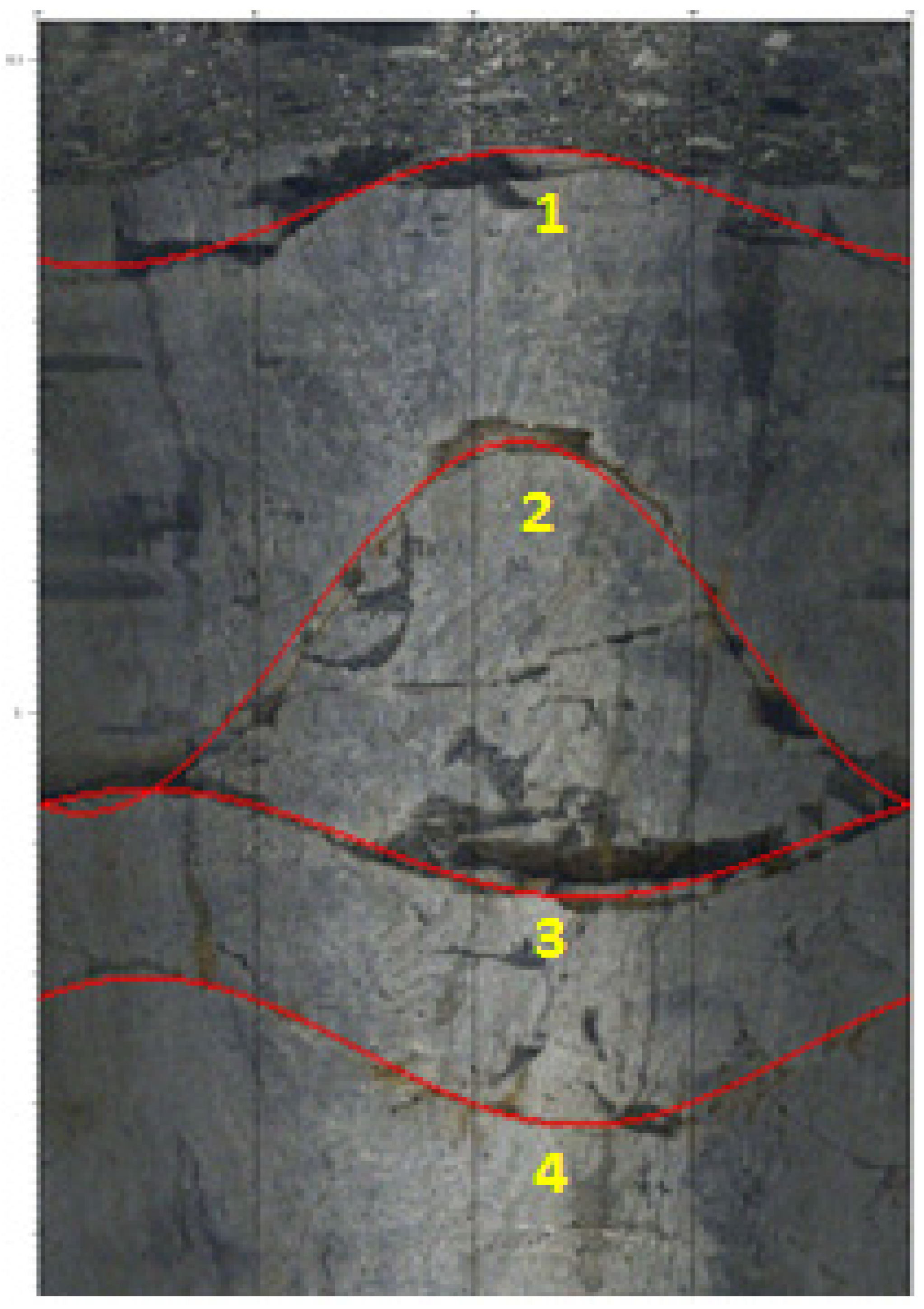
| No. | Depth/m | Dip/° | Dip Angle/° | Gap Width/mm |
|---|---|---|---|---|
| 1 | −0.616 | 154.6 | 44.37 | 8.57 |
| 2 | −1.083 | 162.3 | 71.96 | 9.48 |
| 3 | −1.083 | 315.1 | 41.59 | 10.66 |
| 4 | −1.083 | 315.8 | 50.73 | 6.74 |
| Type | Total Number | Right | Wrong | Missed | RMS (%) | Time |
|---|---|---|---|---|---|---|
| Manual interpretation | 217 | 217 | 0 | 0 | 0 | 7 days |
| Automatic recognition | 196 | 192 | 26 | 21 | 3.2 | 4 h |
Publisher’s Note: MDPI stays neutral with regard to jurisdictional claims in published maps and institutional affiliations. |
© 2021 by the authors. Licensee MDPI, Basel, Switzerland. This article is an open access article distributed under the terms and conditions of the Creative Commons Attribution (CC BY) license (https://creativecommons.org/licenses/by/4.0/).
Share and Cite
Zou, X.; Wang, C.; Zhang, H.; Chen, S. A Practical Method for the Automatic Recognition of Rock Structures in Panoramic Borehole Image during Deep-Hole Drilling Engineering. Appl. Sci. 2021, 11, 10490. https://doi.org/10.3390/app112110490
Zou X, Wang C, Zhang H, Chen S. A Practical Method for the Automatic Recognition of Rock Structures in Panoramic Borehole Image during Deep-Hole Drilling Engineering. Applied Sciences. 2021; 11(21):10490. https://doi.org/10.3390/app112110490
Chicago/Turabian StyleZou, Xianjian, Chuanying Wang, Huajun Zhang, and Shuangyuan Chen. 2021. "A Practical Method for the Automatic Recognition of Rock Structures in Panoramic Borehole Image during Deep-Hole Drilling Engineering" Applied Sciences 11, no. 21: 10490. https://doi.org/10.3390/app112110490
APA StyleZou, X., Wang, C., Zhang, H., & Chen, S. (2021). A Practical Method for the Automatic Recognition of Rock Structures in Panoramic Borehole Image during Deep-Hole Drilling Engineering. Applied Sciences, 11(21), 10490. https://doi.org/10.3390/app112110490