
Detecting Underground Geospatial Features for Protection of Rights in 3D Space: Korean Cases


Abstract
:1. Introduction
2. Methodology
3. Results
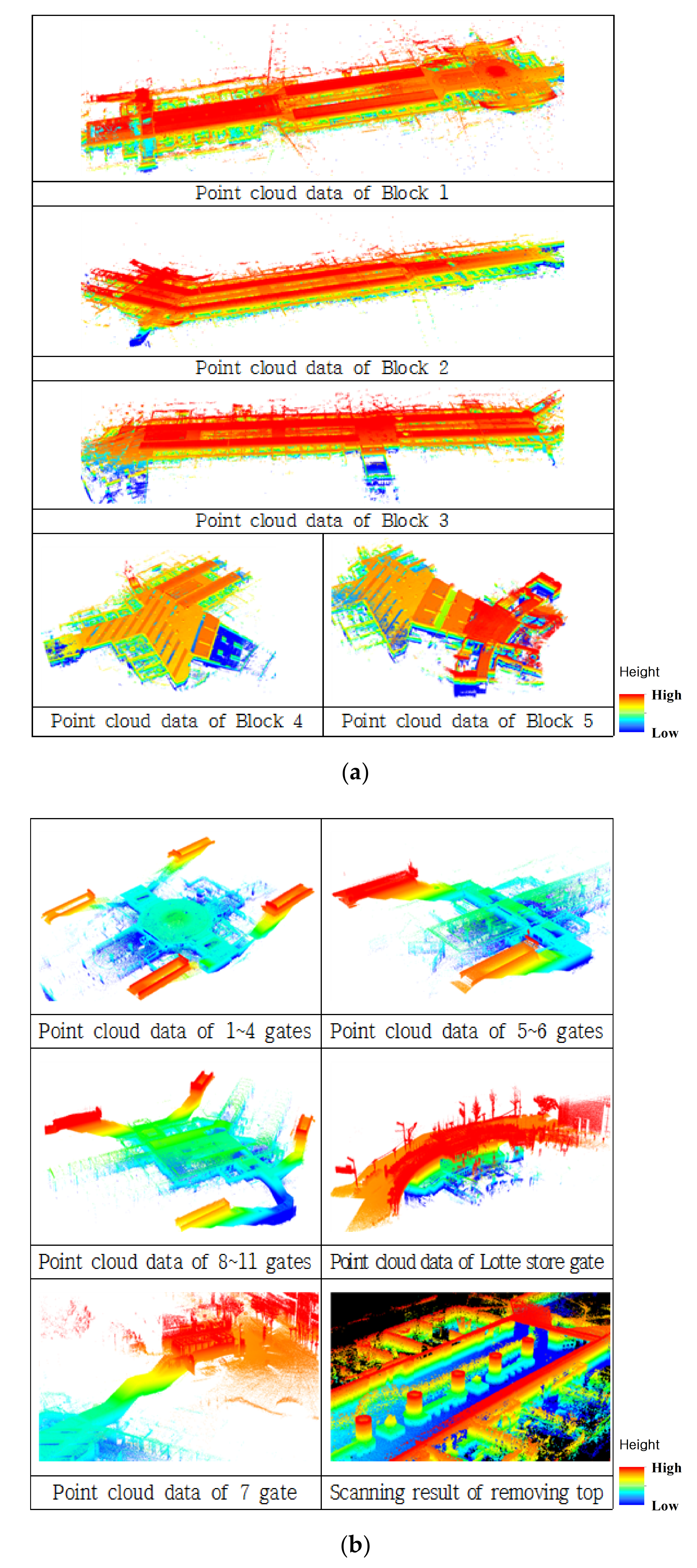
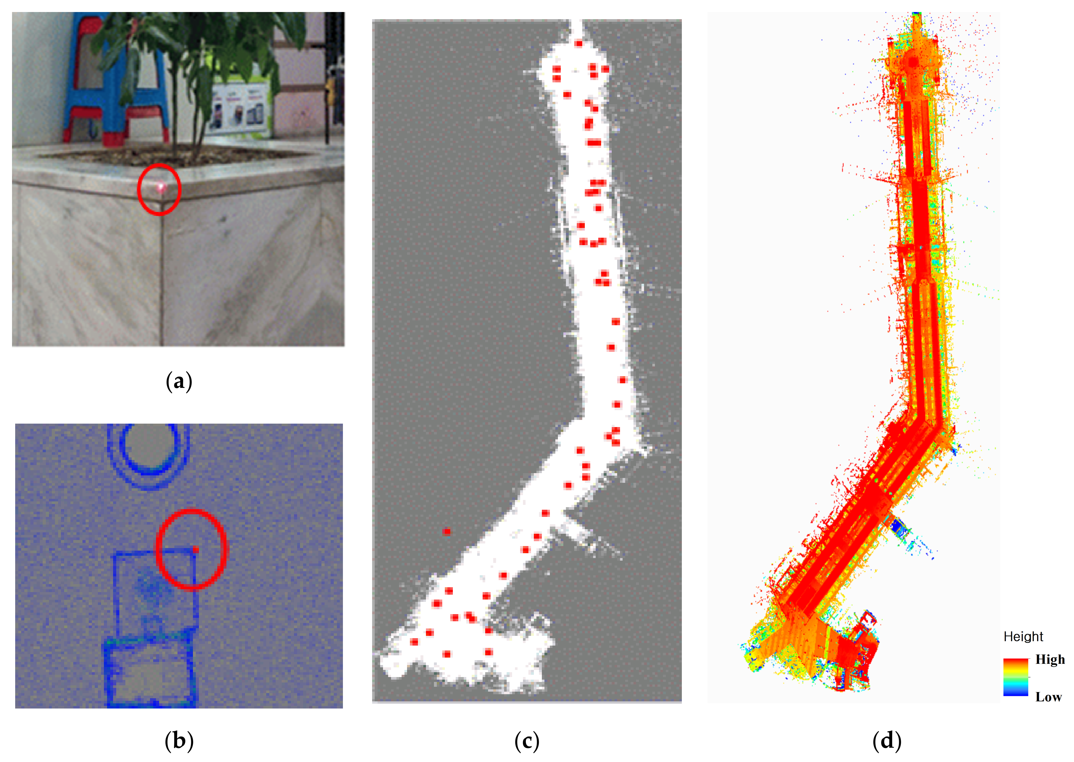
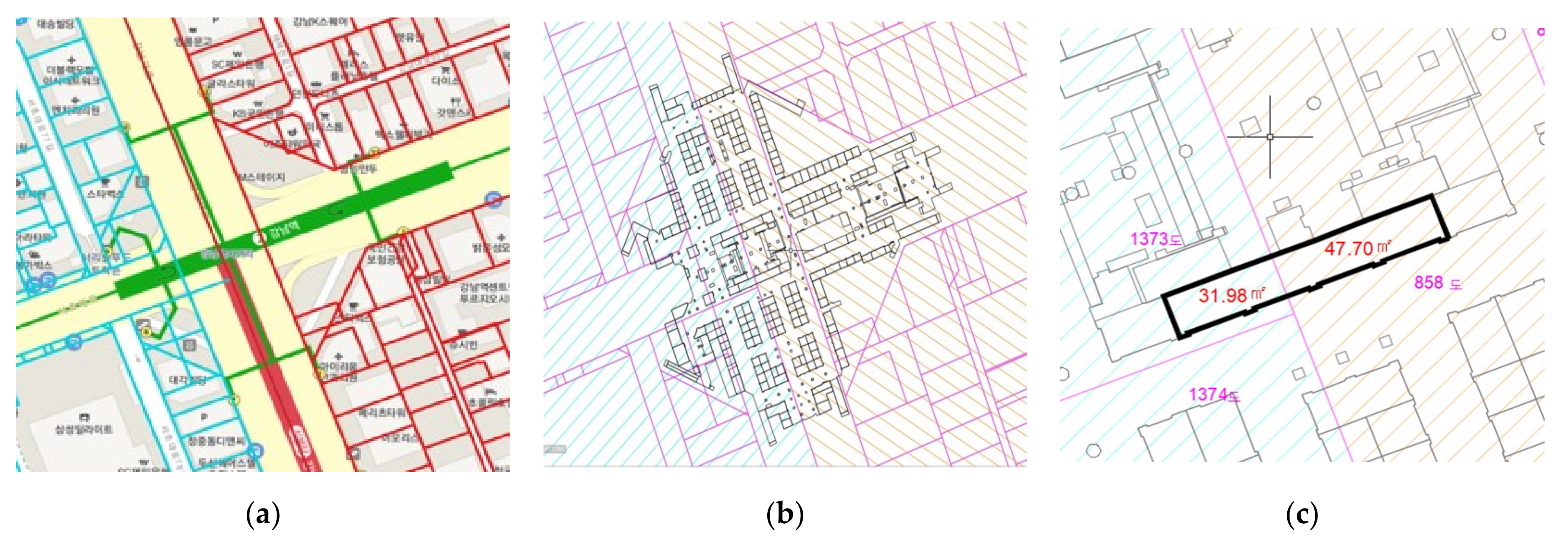
3.1. Direct Survey Method
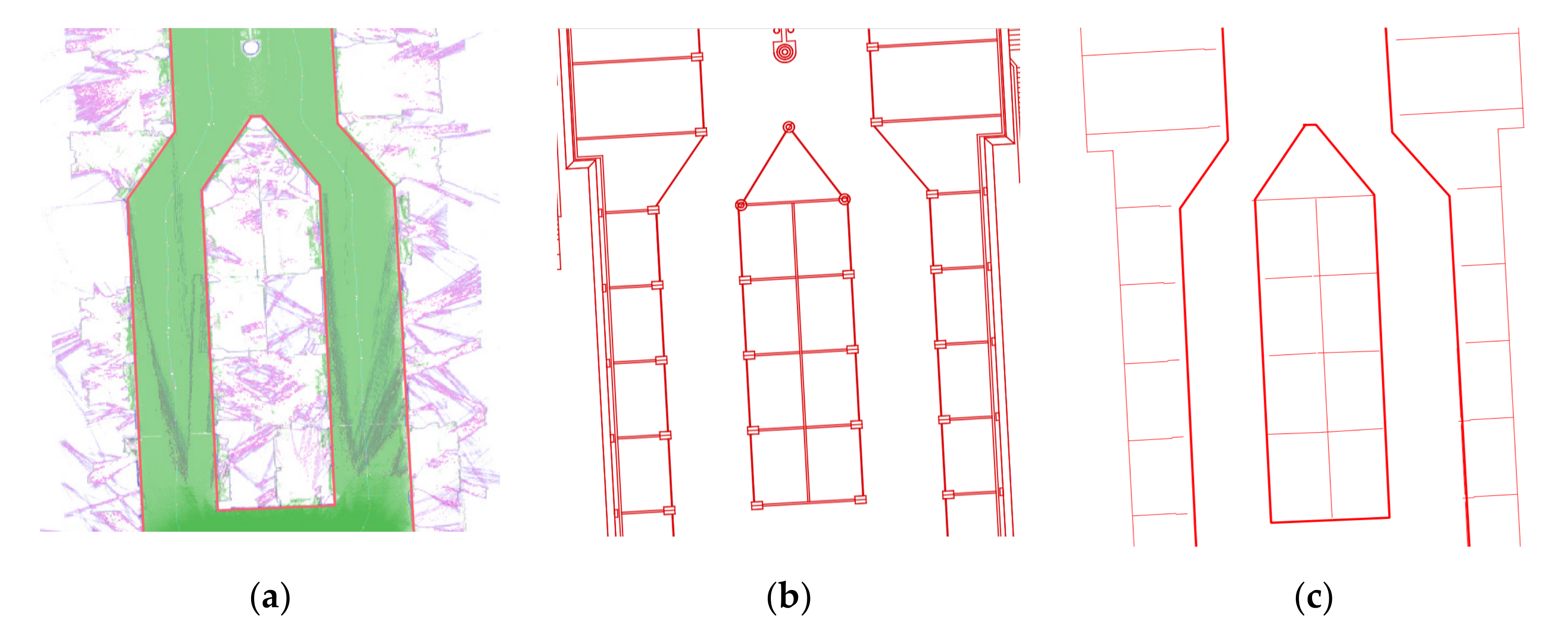
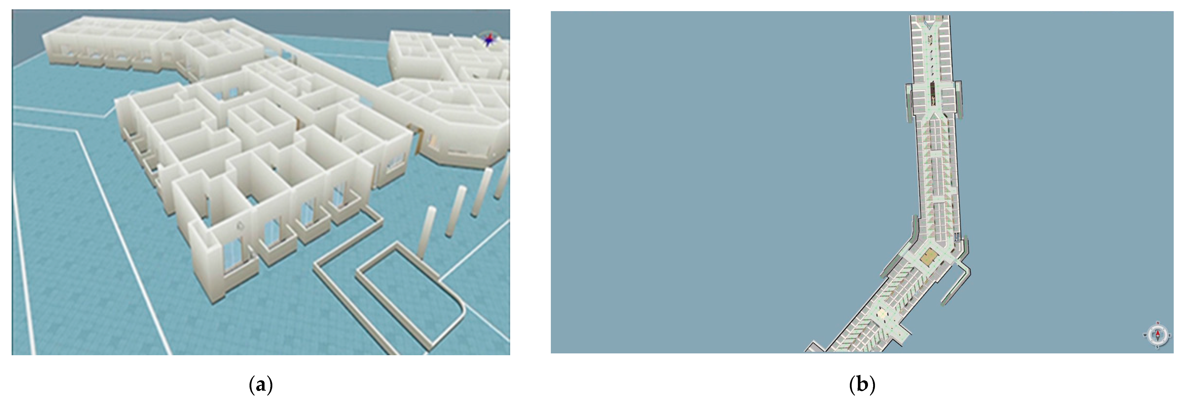
3.2. Method of Using Pre-Built Data
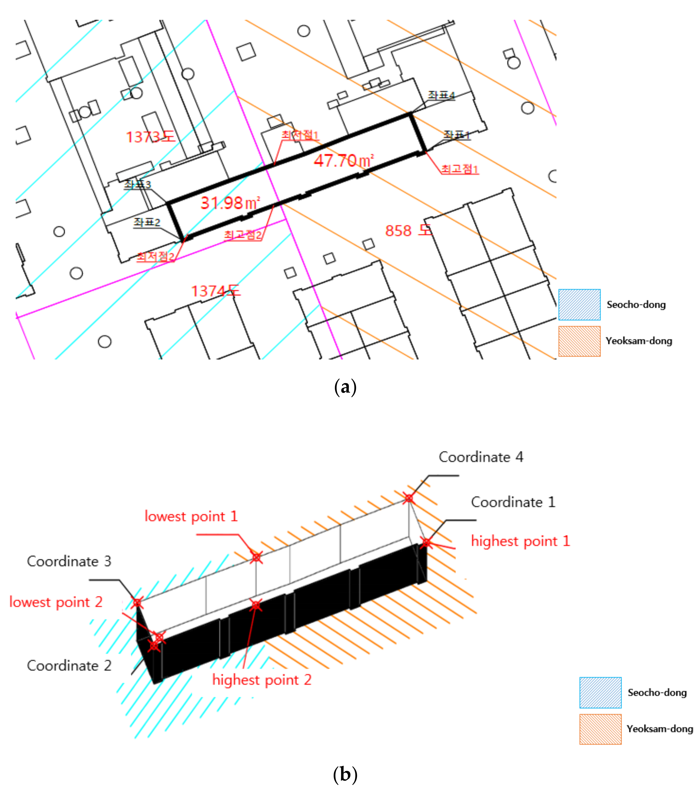
4. Discussion
4.1. Building Data on the Spatial Relation between Ground and Underground Space
4.2. Building Data on the Rights Relation between Ground and Underground Space
5. Conclusions and Recommendation
Author Contributions
Funding
Institutional Review Board Statement
Informed Consent Statement
Data Availability Statement
Conflicts of Interest
Appendix A

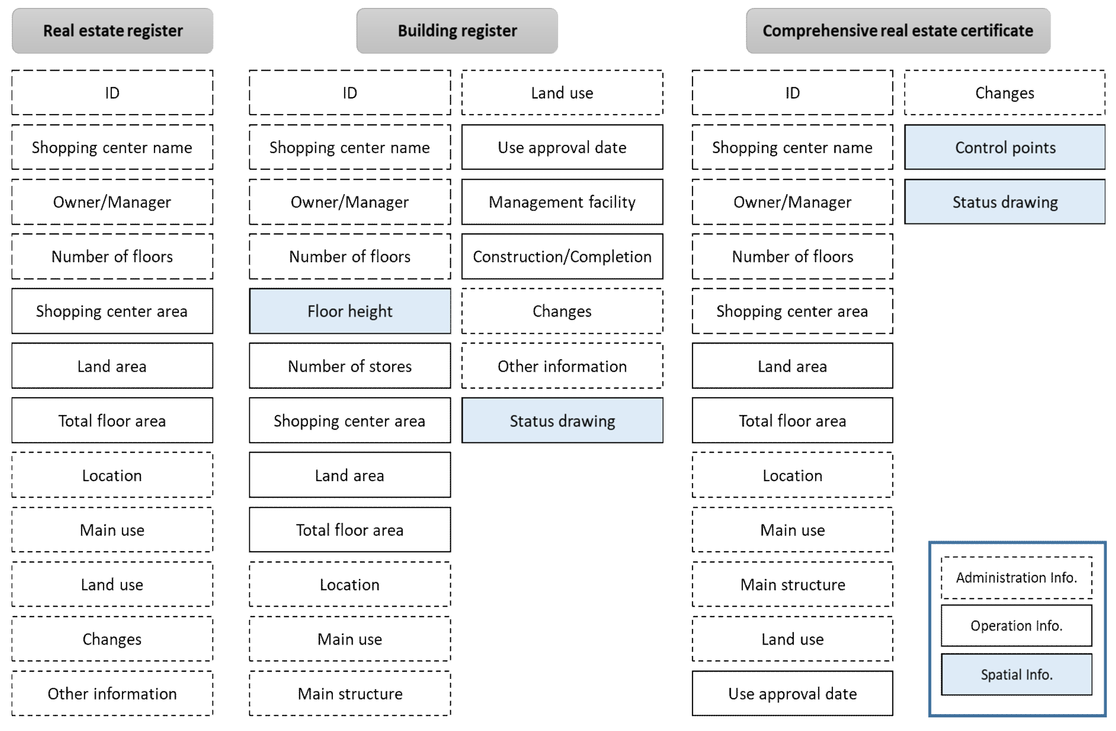
| Classification | Item | Description | Data Type |
|---|---|---|---|
| Object code | Store | Individual stores in the underground shopping center | Number Code |
| Management facility | Facilities, excluding individual stores | Number Code | |
| Shopping center administration information | ID | Unique number of the underground shopping center | Character String |
| Shopping center name | Underground shopping center’s name | Character String | |
| Owner/Manager | Owner/manager’s information | Character String | |
| Number of floors | Total number of floors | Integer | |
| Location | Address of the underground shopping center | Character String | |
| Main use | Main uses of the underground shopping center | Character String | |
| Main structure | Main structure of the underground shopping center | Character String | |
| Land use | Use of the land where the underground shopping center is located | Character String | |
| Use approval date | Use approval date of the underground shopping center | Date | |
| Construction/Completion | Construction/completion dates of the underground shopping center | Date | |
| Changes | Changes in the underground shopping center | Character String | |
| Other information | Other items to be stated | Character String | |
| Shopping center operation information | Number of stores | Total number of stores | Integer |
| Shopping center area | Area of the underground shopping center | Real | |
| Land area | Land area to which the underground shopping center belongs | Real | |
| Total floor area | Total floor area of the underground shopping center | Real | |
| Management facility | Facilities other than stores | Character String | |
| Shopping center spatial information | Floor height | Height of each floor | Real |
| Control points | Control point and boundary point coordinates | Real | |
| Status drawing | Spatial status information between the underground shopping center and the above-ground parcel | Map or Image |
| Classification | Item | Description | Data Type |
|---|---|---|---|
| Store administration information | ID | Unique number of the store | Character String |
| Number of floors | Number of basement floors where the store is located | Integer | |
| Address | Address of the above-ground parcel where the store is located | Character String | |
| Other information | Other items to be stated | Character String | |
| Store operation information | Store name | Name of each store | Character String |
| Store area | Area by store | Real | |
| Business type | Business type by store | Character String | |
| Store spatial information | Depth | Depth information from the ground surface to the store | Real |
| Status drawing | Spatial status information between stores and above-ground parcels | Map or Image | |
| Store rights information | Owner | Store owner’s information | Character String |
| Lessee | Store lessee’s information | Character String | |
| Lease contract | Lease contract information | Character String | |
| Divided superficies | Matters related to the establishment of partitioned space rights | Character String | |
| Other rights | Rights other than lease | Character String | |
| Changes in rights | History of changes in rights relation | Character String |
| Classification | Item | Description | Data type |
|---|---|---|---|
| Management facility code | Operation facility | Facilities necessary for underground shopping centers and store management | Number Code |
| Convenience facility | User convenience facilities | Number Code | |
| Other facilities | Other facilities | Number Code | |
| Management facility information | ID | Unique number of the management facility | Character String |
| Location | Facility’s location information in the shopping center | Character String | |
| Area | Area of facility | Real | |
| Use | Use of facility | Character String |
References
- Bae, S.; Shin, Y.H.; Seo, Y.S. A study on efficient management for information of shopping center in underground passage based on the spatial information. J. Korean Cadastre Inf. Assoc. 2017, 19, 75–87. [Google Scholar] [CrossRef]
- Broere, W. Urban underground space: Solving the problems of today’s cities. Tunn. Undergr. Space Technol. 2016, 55, 245–248. [Google Scholar] [CrossRef] [Green Version]
- Peng, F.; Qiao, Y.-K.; Zhao, J.-W.; Liu, K.; Li, J.-C. Planning and implementation of underground space in Chinese central business district (CBD): A case of Shanghai Hongqiao CBD. Tunn. Undergr. Space Technol. 2020, 95, 103176. [Google Scholar] [CrossRef]
- Zhang, Z.; Paulsson, J.; Gong, J.; Huan, J. Legal Framework of Urban Underground Space in China. Sustainability 2020, 12, 8297. [Google Scholar] [CrossRef]
- Admiraal, H.; Cornaro, A. Future cities, resilient cities—The role of underground space in achieving urban resilience. Undergr. Space 2020, 5, 223–228. [Google Scholar] [CrossRef]
- Von Der Tann, L.; Sterling, R.; Zhou, Y.; Metje, N. Systems approaches to urban underground space planning and management—A review. Undergr. Space 2020, 5, 144–166. [Google Scholar] [CrossRef]
- Qiao, Y.; Peng, F.-L.; Sabri, S.; Rajabifard, A. Socio-environmental costs of underground space use for urban sustainability. Sustain. Cities Soc. 2019, 51, 101757. [Google Scholar] [CrossRef]
- Liu, D.; Wu, L.; Yang, Y. A Hybrid Weight Assignment Model for Urban Underground Space Resources Evaluation Integrated with the Weight of Time Dimension. Appl. Sci. 2020, 10, 5152. [Google Scholar] [CrossRef]
- Zhang, X.; Wang, C.; Fan, J.; Wang, H.; Li, H. Optimizing the Analytic Hierarchy Process through a Suitability Evaluation of Underground Space Development in Tonghu District, Huizhou City. Energies 2020, 13, 742. [Google Scholar] [CrossRef] [Green Version]
- Sartirana, D.; Rotiroti, M.; Zanotti, C.; Bonomi, T.; Fumagalli, L.; de Amicis, M. A 3D Geodatabase for Urban Underground Infrastructures: Implementation and Application to Groundwater Management in Milan Metropolitan Area. ISPRS Int. J. Geo-Inf. 2020, 9, 609. [Google Scholar] [CrossRef]
- Han, S.; Suh, C. A study on the possibilities and institutional burdens of the use of underground space as a substitute of land surface. J. Korea Real Estate Acad. 2003, 21, 178–189. [Google Scholar]
- Lee, K.; Shon, H. Management of Underground Geospatial Information; Sigma Press: Seoul, Korea, 2016. [Google Scholar]
- Meteshkin, K.; Shipulin, V.; Nesterenko, S.; Kobzan, S. Features of underground real estate use: Infrastructural and regional aspects. Geod. Cartogr. 2020, 53–64. [Google Scholar] [CrossRef]
- Stoter, J.E.; Ho, S.; Biljecki, F. Consideration for a 3D Cadastre; GISt Report No. 2; TU Delft: Delft, The Netherlands, 2000. [Google Scholar] [CrossRef] [Green Version]
- Velastegui-Cáceres, J.; Rodríguez-Espinosa, V.M.; Padilla-Almeida, O. Urban Cadastral Situation in Ecuador: Analysis to Determine the Degree of Proximity of the Cadastral Systems to the 3D Cadastral Model. Land 2020, 9, 357. [Google Scholar] [CrossRef]
- Yan, J.; Jaw, S.W.; Soon, K.H.; Wieser, A.; Schrotter, G. Towards an underground utilities 3D data model for land administration. Remote Sens. 2019, 11, 1957. [Google Scholar] [CrossRef] [Green Version]
- Stoter, J.E.; Salzmann, M. Towards a 3D cadastre: Where do cadastral needs and technical possibilities meet? Comput. Environ. Urban Syst. 2003, 27, 395–410. [Google Scholar] [CrossRef] [Green Version]
- Bae, S.; Shin, Y.H.; Seo, Y.S. Development of the management system for underground shopping arcade’s information based on individual objects. J. Korean Cadastre Inf. Assoc. 2018, 20, 51–63. [Google Scholar] [CrossRef]
- Brain Innovation. Spatial Transformation Matrices. Available online: https://download.brainvoyager.com/bv/doc/UsersGuide/CoordsAndTransforms/SpatialTransformationMatrices.html (accessed on 15 January 2021).
- Bae, S.; Kim, S.M.; Lee, Y.J. Construction of underground space registration information using public data. J. Korean Soc. Cadastre 2020, 36, 23–37. [Google Scholar]


| Classification | Specification | Quantity | Product Image |
|---|---|---|---|
| Optical Camera |
| 6 | 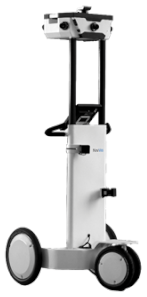 |
| Laser Scanner |
| 3 | |
| Sensors |
| 1 | |
| System Performance |
| 1 |
| Operating Body | Ministry of Land, Infrastructure and Transport (Korea) | |
|---|---|---|
| Raw data open | Restricted disclosure (approval required) | |
| Service scope | Administration-use and public-use | |
| Data format | 2D | shp, dwg, dxf |
| 3D | imp, asc, 3ds, max | |
| Attributes | 3D texture code table, structured layer definition, structured classified code classification table, position layer classification table, POI classification table, building code design table | |
| Data universality | Raw data (imp format file) can be operated in specific software | |
| Main operating programs | Autodesk 3D MAX, AutoCAD, Leica Cyclone | |
| Data coordinate system | Absolute coordinates | |
| Data usability | Difference in constructed data between data generations periods, information inconsistency between 3D data and POI | |
| Supplementary Control Points Used | Bessel Result | World Geodetic System Result | Elevation | Remarks | ||
|---|---|---|---|---|---|---|
| X Coordinate | Y Coordinate | X Coordinate | Y Coordinate | |||
| 1048 | 177,746.24 | 203,190.68 | 278,056.11 | 203,249.15 | 2.477 m | 1st supplementary control (re-established in 2008) |
| 903 | 177,723.78 | 203,066.15 | 278,033.60 | 203,124.64 | 1.979 m | 1st supplementary control (re-established in 2008) |
| 129 | 178,099.64 | 203,280.58 | 278,409.46 | 203,338.97 | 1.599 m | 1st supplementary control (re-established in 2008) |
| 130 | 178,058.39 | 203,254.60 | 278,368.23 | 203,312.98 | 1.492 m | 1st supplementary control (re-established in 2008) |
| Newly Established Supplementary Control Points | Bessel Result | World Geodetic System Result | Elevation (H) | Remarks | ||
|---|---|---|---|---|---|---|
| X Coordinate | Y Coordinate | X Coordinate | Y Coordinate | |||
| 1 | 177,689.45 | 203,172.56 | 277,999.29 | 203,231.05 | 2.041 | Ground installation |
| 2 | 177,678.09 | 203,144.73 | 277,987.93 | 203,203.23 | 2.629 | Ground installation |
| 3 | 177,669.29 | 203,120.48 | 277,979.12 | 203,178.98 | −6.792 | Underground installation |
| 4 | 177,651.40 | 203,129.27 | 277,961.24 | 203,187.77 | −6.762 | Underground installation |
| 5 | 177,686.40 | 203,188.18 | 277,996.25 | 203,246.68 | −5.225 | Underground installation |
| 6 | 177,805.34 | 203,286.67 | 278,115.21 | 203,345.14 | −4.910 | Underground installation |
| 7 | 177,952.24 | 203,278.28 | 278,262.10 | 203,336.73 | −5.301 | Underground installation |
| 8 | 178,022.74 | 203,274.68 | 278,332.60 | 203,333.11 | −5.427 | Underground installation |
| 9 | 178,024.49 | 203,286.17 | 278,334.35 | 203,344.60 | −5.420 | Underground installation |
| 10 | 178,045.00 | 203,284.29 | 278,354.86 | 203,342.71 | 2.213 | Ground installation |
Publisher’s Note: MDPI stays neutral with regard to jurisdictional claims in published maps and institutional affiliations. |
© 2021 by the authors. Licensee MDPI, Basel, Switzerland. This article is an open access article distributed under the terms and conditions of the Creative Commons Attribution (CC BY) license (http://creativecommons.org/licenses/by/4.0/).
Share and Cite
Bae, S.K.; Kim, J.O. Detecting Underground Geospatial Features for Protection of Rights in 3D Space: Korean Cases. Appl. Sci. 2021, 11, 1102. https://doi.org/10.3390/app11031102
Bae SK, Kim JO. Detecting Underground Geospatial Features for Protection of Rights in 3D Space: Korean Cases. Applied Sciences. 2021; 11(3):1102. https://doi.org/10.3390/app11031102
Chicago/Turabian StyleBae, Sang Keun, and Jung Ok Kim. 2021. "Detecting Underground Geospatial Features for Protection of Rights in 3D Space: Korean Cases" Applied Sciences 11, no. 3: 1102. https://doi.org/10.3390/app11031102