1. Introduction and Objectives
Slope movements in mountains affected by glacierism can be strongly influenced by the advance and, especially, by the retreat of glaciers. The advances of the ice through the valleys excavate and cause a decompression in the rock mass. However, when the glacier retreats, the slope is left without ice support, the valley is deeper, the excavated slopes steeper, and decompression continues.
Steep slopes and greater than 500 m can undergo slow and continuous deformation, characterized by its bulging and the appearance of lateral escarpments parallel to the level lines (“sackung”). It is a gravitational spreading or gravitational slope deformation [
1,
2,
3]. Their formation is usually previous to the generation of large landslides [
4,
5,
6]. If these landslides originated natural dams and lakes upstream, the dating of these lake sediments can be used to assess the risk of flooding due to the collapse of these dams [
7], or for paleoclimatic investigations and geomorphological evolution studies, such as improving the information on deglaciation in mountain areas (for example, in the Pyrenees [
8]).
The formation of large deep landslides due to the retreat of valley glaciers after the last glacial cycle has been described in many mountainous areas, such as the Alps, Himalaya, Rocky Mountains, Andes, New Zealand, etc. [
9,
10,
11,
12,
13]. Additionally, in mountains recently abandoned by glaciers, where the retreat and thinning of glaciers have been experienced worldwide in recent decades as a result of global warming, it has directly affected the stability of the slopes (for example, in Patagonia [
14]).
In Spain, they are described in the Cantabrian Mountains in [
15], for example or in the Pyrenees [
16,
17,
18,
19,
20,
21,
22]. Although in the Iberian Range the Demanda, Neila, Cebollera, and Moncayo mountain ranges were affected by Pleistocene glacierism, most of the time they were glacier cirques with tongue of little erosive capacity and incapable of generating these phenomena. There is only one antecedent to the case presented here, where a notable example of a landslide associated with the retreat of the 5 km glacier on the north face of the Picos de Urbión is briefly described [
23].
On the other hand, and as is known, the identification, recognition, inventory, and detailed study of these movements can inform us about the failure mechanisms and the causes that generated them. A good characterization of a landslide includes an adequate investigation of the internal architecture and hydrogeology, and in the works [
24,
25,
26], we can find good examples of case studies of large landslides and of the different methodologies followed.
When retrospective modeling is done, the initial topography before the landslide has to be reconstituted, and in this sense, the three-dimensional reconstruction of the pre-landslide topography has been carried out by several authors using different methodologies and applying different criteria [
27,
28].
The objectives pursued in this work are the following: (1) Characterize this great landslide from the geological and geomorphological point of view; (2) Reconstruction of the original slope and, after geomechanical characterization of the geological materials and hydrogeological conditions, analyze the failure using an appropriate numerical model in order to identify the factors and causes that have controlled the development of the landslide (back analysis); (3) Integrate the process of landslide within the context of paleo-evolution and deglaciation of the glacier of the Picos de Urbión.
2. Site Description
2.1. Study Area
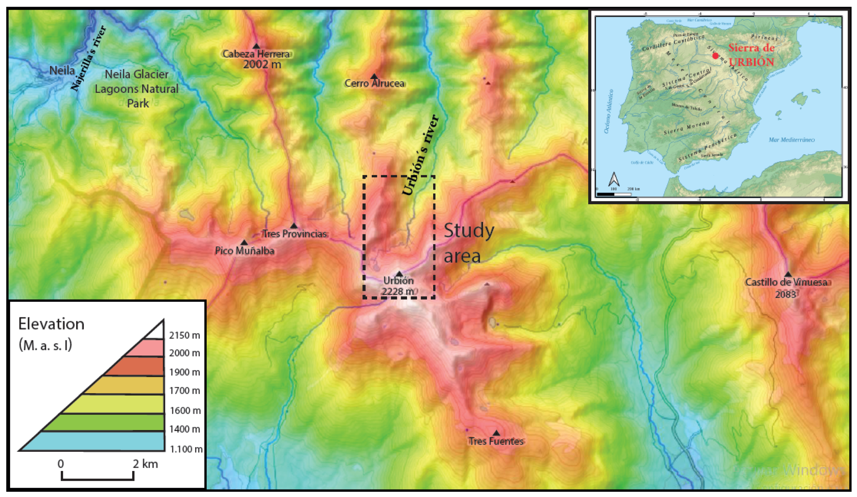
The Sierra de Urbión is part of the northwestern sector of the Iberian range. It is one of the highest mountain ranges in the Iberian System, in northern Spain, reaching its maximum altitude at 2228 m above sea level (
Figure 1). This mountain range serves as a watershed between the Duero river basin and the Ebro river basin. The north slope includes, among others, the headwaters of the Urbión river, a tributary of the Najerilla river, and which is a tributary of the Ebro, while in the southern slope has its source the river Duero. The main watershed runs from west to east and is approximately 25 km long, the highest elevation being the Picos de Urbión, although there are other holm oak peaks of 2000 m, such as Zorraquin (2105 m) or Muñalba (2073 m). To the east it continues with the Sierra de Cebollera, and to the west by the Sierra de Neila, both with peaks a little over 2000 m.
The climate is Mediterranean and mountainous, with wet tendencies. Average annual rainfall is probably above 1500–1600 mm in the main watershed, falling mainly in Spring and Winter. According to Camarero and Gutiérrez [
29], the minimum of precipitation is in Summer (from July and August), and the maximum from November to February. The Atlantic influence is more noticeable on the northern slope than on the southern one. In the summits a certain aridity is observed in July and August since the precipitation is less than 40 mm.
The Urbión mountain range was affected by Pleistocene glacierism, which in the valley of the north face studied here left U-shaped valley up to 5 km long (Figure 2), descending the glacier to 1270 m.a.s.l. [
30]. The studies on quaternary glacierism began at the beginning of the 20th century with the work of Carandell and Gómez de Llarena [
31], and which continued Thornes [
32], and Sanz Pérez [
33]. The identification of different glacial stages was possible in the Neila and Urbión mountain range thanks to sedimentological studies in Laguna Grande and Laguna de Hornillo, respectively [
34,
35]. Another palynological study in the Urbión mountain range [
36] covers the last 15,000 years.
2.2. Substrate Geology
The general architecture of the Urbión mountain range is resolved in a great slope whose structure is determined by the soft and generalized inclination of the stratigraphic series towards the south, with variable dips between 9° and 20°. The front of the slope is oriented to the north, which is where the oldest layers emerge. Thus, going up the valley of the Urbión river, from where the glacier ended up to the Picos de Urbión in a north–south direction, there are the following types of grounds arranged from oldest to most modern [
37] (Figure 2): (25) Cambrian quartzites, on which (24) sandstones, conglomerates, marls and clays of the Triassic are supported in discordance. Above it appears a Jurassic calcareous sequence consisting of about 350 m of dolomite, limestone, and dolomitic limestone (23). These Paleozoic, Triassic, and Jurassic outcrops extend almost exclusively along the northern slope; for example, limestone can reach altitudes close to 1900 m, at the head of our landslide. The Tera, Oncala, and Urbión groups are located on top of the calcareous marine Jurassic and in soft discordance, belonging to the facies of the Cameros Basin (Upper Jurassic–Lower Cretaceous), and which are constituted primarily by the unit (22) formed by clays and purple lutites and sandstones. It has a thickness in the area of the slide of 160 m, but it is highly variable and can also present lateral change of facies. This is the unit where the landslide has occurred. Above, the unit (21) is distinguished where there is a powerful series of up to 500 m of alternating strata of sandstones, conglomerates and marl, and which is more competent than the previous one. It ends with the unit (20) in the summits of Urbión, formed by a very hard level of quartzite conglomerates, massive, 80 to 200 m thick, which gives rise to the ledges and rocky outcrops at the top.
In the area of the landslide, the geological contacts of the layers (23)–(22)–(21) are parallel, with an east–west direction, and dip about 30° to the south; the contact (22)–(23) is flexed decreasing the dip towards the north up to 10°.
2.3. Geomorphology and Surface Formations Linked to the Quaternary Glacierism of the Urbión River Valley
Before the quaternary, these rock masses of the Urbión mountain range were modeled with smooth shapes and regularized slopes, defining a summit line at 2000 m which is not as clearly manifested as in the neighboring Cebollera mountain range. Later, a glacierism was installed in the highest sections of the valleys, accommodating the pre-existing relief. In Urbión, the special morphology with a gentle slope at high altitude, the orientation of the mountain range, and the greater influence, as in Neila, of the wet masses from the northwest, determined the development of valley glaciers of certain size on the north and east slopes [
38]. The orientation in the shade and the overfeeding of the snow due to the effect of the blizzard favored the accumulation and conservation of ice.
The cirque is subdivided into two other; the western one is larger and more excavated than the eastern one, which has softer slopes (
Figure 2). That one was better fed by the blizzard and should be the engine and main producer of glacier ice. In the middle of the two, a deposit corresponding to the start of the medial moraine, originated by the union of the two glacial tongues, has been preserved at an elevation of 1900 m. In the left cirque (called Alborta), where the Urbión Lagoon is located, there is a large basal moraine containing coarse and very coarse boulders [
39]. About 800 m below there is an over-excavation carved into the substrate, as well as some small moraine deposits on the basal (
Figure 2).
In the left cirque there are erosive and sedimentation traces corresponding to marginal glaciers. Traces of snowfield moraines (protalus rampant) remain on the left slope, one in arc-shaped, and the other more rectilinear on the upper side. The large moraine of the Urbión Lagoon is kept very fresh, with two arches corresponding to the respective backward pulsations. Further to the left appears another fork-shaped one that holds another small lagoon. There are coarse and very coarse boulders transported by the ice. In the right cirque the protalus rampant had, as expected, much less development. Here there are small arc-shaped and rectilinear snowfield moraines, which also reveal two pulsations.
The valley has a very characteristic, asymmetrical “U” profile, as the slopes on the left bank have supported the action of snowfields that fed the glacier on this side. The left zone lacked important snowfields. The lateral moraine is very well preserved, with a start at 1930 m. under Cerro Pantorra, where it is modified by the action of old snowfields from the glacial retreat phase, mixing up the moraines of both devices. There are other clearer regions along the slope of the valley, which gives a descent slope of 6° to 7°. This moraine causes lagoons of obstruction of very little importance. At the bottom there is an over-excavation gap carved into the substrate, as well as some small bottom moraine deposits. In the cirque on the right side there are alluvial deposits in sheets, which cover the slopes, originated by the erosion of the moraines at the bottom. On the right slope, at an elevation 1700 m, there are three aligned regions of lateral moraine. This shows the asymmetry of the glacial tongue, with a transverse slope to the right of 10°. On the right slope, the substrate outcrops, and in the lower part a blanket of debris spreads.
In general, the valley loses its typical “U” shape downstream of 1580 m, but it is undoubted that below this level the lower parts of the slopes have been retouched by ice, acquiring a profile that tends to approach “U” but not clearly in V either; furthermore, the left slope is distorted by convex ledges due to later slope movements and alluvial fans.
At the maximum advance of the glacier there are three pieces of lateral moraines located on both slopes of the lower part of the valley, three on the right (1700, 1655, and 1625 m) and one on the left (1645 m) (
Figure 2 and
Figure 3).
The right lateral moraine deposit located at 1625 m has a rectilinear projection and a sharp top, raised about 2–4 m on the flat bottom of a valley filled with moraine plugging deposits that closed the glacier with this moraine. Its transverse profile is triangular, filling in the middle of the slope, lowering the outer slope until very low attached to the slope, as if fed by rimaye. This moraine is made up of sandy reddish sediments and a silty matrix and few boulders. It has developed soil where the pines take root. This soil and the type of alteration is exactly the same in these three zones, but different from the soil developed on the lateral moraines of the upper part of the valley.
The end of the glacier does not present terminal moraines, but it can be recognized in the topography by the trace of erosion carved in the valley by the tongue. Thus, towards an elevation of 1270 m, the profile of the valley changes from more or less concave slopes to rectilinear slopes. This should be interpreted as a supporting argument, although the existence of these hanging lateral moraines is conclusive evidence of the true extent of the glacier.
4. Results
4.1. Landslide Characteristics and Dimensions
The characteristics of this earth movement correspond to a large rotational landslide that affects the clays and lutites of the unit (22). Despite its age, it retains its own characteristics: a main scarp 155 m high, whose upper edge reaches the Cerro de Navillas (1925 m) (
Figure 2 and
Figure 3). This scarp has an asymmetric semicircular projection and is 1000 m long, covering the entire width of the outcrop of the unit (22), and being the contact with limestone (23) to the north and with sandstones (21) to the south. There is a head at the foot of the scarp with flooded areas (around 1765 m). The landslide extends 1.2 km in length to the river, and the removed mass expands downward with an average width of about 800 m (
Figure 3). The area is about 0.75 km
2. As the maximum depth of the failure surface is about 200 m, this slide involves around 150 Mm
3. The most characteristic of the slipped mass is an irregular ridged relief in transverse grooves subparallel to each other (
Figure 2 and
Figure 3). The foot invaded more than 1 km of the river that moved 250 m to the east, bringing the riverbed into contact between the landslide and the right slope, between levels 1490 and 1540 m, approximately. The slope of the landslide is about 400 m. The foot has a scarp of 20 to 25 m as a result of the deepening of the Urbión river (see
Table 1).
Within the slipped mass, a subscarp (minor scarp) is seen in the upper part where two appreciable water sprout are born at the 1720 m elevation that originates the source of the stream that forms the alluvial fan. There are other small surfaces as a consequence of minor landslides below.
The mobilized material consists mainly of a mass of lutites and clays, but there are also fragments and boulders of sandstone. In the upper part of the landslide, the material comes entirely from unit (22), but from the middle downwards there are also materials similar to those of the nearby lateral moraine, formed by sandy reddish earth, although their distinction is not easy.
The mobilized lutites have undergone an alteration and clayey materials predominate on its surface. This surface alteration of these lutites is a characteristic of these when they are exposed to the atmospheric agents for short periods of time. It is common to verify the degradation of up to 5 m in depth on the slopes cuts of the roads of the area in a few years. It also constitutes a problem in the conservation of the dinosaur ichnite sites when the soil that covered them has been removed.
4.2. Pre-Landslide Topography and Geology Reconstruction
The retrospective analysis of a landslide through mathematical modeling requires knowledge of the topography and geology prior to it. This is a characteristic difficulty in landslides as old as this one. However, and despite having a certain degree of subjectivism, we believe that in this case there are geomorphological-geological criteria of the environment and information on the geometry of the landslide sufficient to address this aspect with guarantee. Thus, a methodology is proposed to reconstruct the pre-landslide topography in 3D that approximates with sufficient detail to the proposed purposes.
The reasoned steps that have been followed for the reconstruction of the topographic and geological profile are the following (see
Figure 4):
1. First, it is necessary to start from two certainties: one, that the failure of the landslide exclusively affected the formation of clays and lutites (unit 22), and is limited towards the base, by the presence of the hard layers of limestone (contact 22–23) north and in depth, and to the roof by unit 21 that outcrops to the south. The second certainty is that the slide occurred at some point in the retreat of the glacier during deglaciation. This is evident since the lateral moraine that remains with the slide has been cut by it (
Figure 3D). It is seen that the moraine continued on the slope where the movement occurred. In other words, the slope was stable before the glaciation and also during the maximum advance of the glacier (supporting the slope by the ice tongue).
The fact that the slope remained stable with its natural slope before the glaciation is very interesting from the geotechnical point of view, since it informs us of the minimum angle of stability. This angle is 14° and is the one that has the slopes of the valley above the lateral moraines not affected by the glacial excavation and which are very well preserved. The height of the slope before the glaciation was about 300 m (1900–1600 m).
2. Reconstruction of the topography of the pre-glacial valley is not difficult as it is fairly well preserved in the upper part of the slopes unaffected by glacier erosion. It is a regularized and constant slope of about 14° that, prolonged for both slopes downwards, emerges a height from the bottom of the pre-glacial valley in this sector where the landslide is located (towards 1600 m) (
Figure 2 and
Figure 3). It is thus deduced that on the left bank, where the outcrop of clays and lutites gave rise to the landslide, was stable with a natural slope of 14° and a drop of 300 m (1900 from the head minus 1600 m from the bottom of the valley). In the area affected by the landslide, the lateral moraines on the left bank, which were dragged by this mass movement, are not preserved. In the area on the right bank, the lateral moraine perched over three valleys, as has been said, is very well preserved.
3. However, we are interested in knowing the topography and geology just before the landslide, as a result of the excavation of the pre-existing valley by the glacier.
Thus, the contour lines of the slopes of both sides of the landslide have been extrapolated, both on the slopes above the lateral moraines not affected by glacial erosion with a slope of about 14°, and on the slopes below the moraines, with a slope of about 40°. The limit for the extrapolation of both slopes is imposed by the deduction of the situation of the maximum extent of glacier ice according to the location of the lateral moraines. It has also been taken into account that the axis of the bottom of the valley before the landslide was located about 250 m to the west of the current one, since the mass movement invaded it and displaced the river to the east. This displacement can be very well measured by joining the rectilinear north–south channel of the Urbión River upstream and downstream of the landslide (Figure 9(0)). The bottom of the valley was also about 20 or 25 m above the current one: this can be observed very well in the unevenness of the river embedding in the mass of the slide and in the associated alluvial fan (
Figure 2 and
Figure 3B). All this has been taken into account to reconstruct the topography of the valley excavated by the glacier that is presented in the geological map of
Figure 4B.
To reconstruct the geology of the substrate in the valley, the contour map method has been used, drawing geological contacts 22–23 and 22–21 in the pre-glacial topography, for which the current outcrops and dips have been used. This is what is represented in
Figure 4B, that is, the geology of the substrate under the surface formations of the moraines, the mass of the landslide and the alluvial fan.
On the topography of
Figure 4B, the thickness of the lateral moraines has been added, supposedly covering the entire valley. The end result is a topographic map of the valley floor before the slide, under the ice of the tongue, which is not shown here. In
Figure 4C the exterior topography is represented with the level curves of the glacier surface at its maximum apogee, assuming this gently convex and slightly asymmetric surface as a result of taking into account the altitudes of the moraines, of about 25 m higher elevation on the left than on the right. We have assumed that the bottom of the valley is the situation of the maximum glacier phase, and that this bottom no longer descended when the glacier was receding. If we admit this, it follows from these maps that the maximum thickness of the glacier tongue at its maximum advance was, in this zone of the slide, of no more than 140 m.
4. Reconstruction of the topography during the retreat of the Pico de Urbión glacier. Although the logical thing was to think that the slope would failure until the complete disappearance of the glacier, canceling the wall-wedge effect of the ice at the foot of the slope, they have tried to simulate the intermediate situations in the retreat of the glacier to exhaust all the possibilities. Thus, in
Figure 4D, the topography in the glacial retreat is represented by way of example, considering a thickness of the ice tongue of 40 m and keeping the bottom topography constant. In the latter situation, the glacial front had receded almost 2 km and was in this sector of the valley. The end of the glacier was residually restricted to the narrow valley bottom, increasing its volume on the rise of the topographic step of contact 21–22.
If we look at the profile corresponding to the final situation in Figure 9(2), the difference in slope level has increased with respect to before the glaciation from 300 to 375 m and, with respect to the slope, it remains 14° above 1675 m, up to 1900 m from the summit. It has increased in the lower part to 40° from 1675 m to the bottom, located around 1525 m.
Figure 5 shows two geological sections along the landslide where it can be seen that practically the entire unit (22) has been mobilized, limit of the failure in depth, and which has been exceeded in the foot of the slide. The dip, relatively in favor of the slope, has contributed to the landslide.
With regard to retrospective modeling, and taking into account all these considerations, the hypothetical geometric configurations have been reconstructed before the landslide (
Figure 6). In this way, the sliding conditions can be reproduced when a stability analysis is performed starting from the original geometry.
4.3. Hydrogeological Context
The limestones and dolomites of the marine Jurassic (23) are very permeable and give rise to karst aquifers in the area, associated with important upwellings, such as those of Viniegra de Cameros, or the source of the Arlanza river, which constitutes a natural transfer of water from the Ebro basin of the Sierra de Urbion to the Duero basin [
41,
42]. Small dolines and karren abound in the limestone surrounding the landslide, quite frequent in the area [
43]. The lithologies (21) and (22) are generally quite impermeable, especially the clays and lutites, although there are sometimes small springs associated with the sandstone levels.
In the area of the landslide in particular, there are hardly any springs at the foot of it, and the Urbión river in this section is not affected. The rest of the landslide is relatively wet and hydromorphic soils sometimes appear although not as much as one would expect from a large loose mass like this one. It is quite possible that the slipped mass has underground drainage directed towards limestone below on which it largely rests. This good underground drainage must have influenced the stability of the landslide once it was formed. However, the important springs are at the top, where two sources of 1 l/s each appear, in low water, at an elevation of 1720 m, and which gives rise to a stream that circulates through the bed of a torrent, filtering in the sediments of its alluvial fan (
Figure 4D). These springs must be related to the presence of a sandstone level interspersed between the clays and lutites of the substrate and for an unknown reason they sprout in the upper-middle part of the slope. They are well fed by the recharge that operates in the watershed at 1900 m. In any case, it is indicating that the water table is linked to the substrate and is high, with a hydraulic gradient that follows the slope of the slope. This is very significant in order to know the causes of the slope movement, since the same situation of the water table at the head has been preserved until now, in reality it is making us see the importance that the water table should have had. In fact, the spring area coincides with a minor slide.
4.4. Geotechnical Characterization of the Materials Involved
4.4.1. Geotechnical Interpretation of the Geomorphology of the Place
Apart from the laboratory tests on representative samples of the sliding unit (22), there is a geotechnical reading of the geomorphology of the landslide zone:
The slope of the unit (22) before the landslide was stable with a 300 m drop and a 14° slope.
The landslide occurred with a slope height of 375 m and a slope in the upper half (250 m) of 14° and 40° in the lower half (150 m), approximately.
The lateral moraines have remained stable for thousands of years as fillings in the mid-slope of 140 m in height with a slope of 40°. The only area where it has not remained stable is when it rested on the unit (22).
4.4.2. Inference of the Geotechnical Characteristics of the Lutites Unit
These lutites and sandstone materials, corresponding to the Tera Group very close to contact with the limestone of the marine Jurassic, have been tested in detail in the foundation of the Castrovido dam in the Arlanza river (Burgos). That is, they correspond to the same stratigraphic location, where Alonso et al. [
44] made an extensive study of these lutites with field and laboratory geomechanical characterization, indicating effective cohesion values between 20 and 100 kN/m
2 and effective friction angle values between 17° and 33°.
4.5. Back Analysis
Once the pre-failure topography has been recreated, its stability was studied using a 3D model with the software fast Lagrangian analyses of continuous (FLAC) 3D, a software developed for the geotechnical calculation by ITASCA group. It is based on the method of finite differences, which allows the use of non-linear behavior laws, with an explicit resolution scheme of the differential equations of the geotechnical problem. Although the medium is divided into elements formed by quadrilaterals, FLAC internally divides the quadrilateral into two superimposed groups of triangles of constant deformation of triangular elements.
The values of the geomechanical parameters of the sandstones and limestones substratum do not control the failure but must be reasonably estimated. All materials are modeled with a Mohr–Coulomb failure criterion, with parameters assigned according to
Table 2, where the average values proposed by [
45] for the sandstones and limestones have been used. The lowest strength corresponds to lutites, where instability is predictable and the geotechnical characteristics that have been considered correspond to the study interval of the geotechnical research referenced [
44]. Therefore, it is advisable to conduct a sensitivity analysis to study global stability with different geotechnical parameters that define the level of lutites.
For the boundary conditions, horizontal constraints for laterals contours and both horizontal and vertical constraints for the lower boundary of the model are considered. First of all, initial stresses under static conditions (only under vertical gravity loading) are calculated, considering the water pressure caused by the situation of the water table at the head as is indicated in
Section 4.3. The estimation of horizontal effective stresses has been performed with Jaky’s formula because, even if this is not a horizontal layered soil configuration, it can be considered accurate enough for this estimation.
For the back analysis, a sensitivity analysis by varying the strength parameters of the geotechnical unit of lutites is considered. It has been necessary to reduce cohesion to values of 20 kN/m
2 and friction angles of 24° to induce breakage. A lower value of cohesion for this material is hardly realistic as previously mentioned. As can be analyzed, these values are consistent with those studied by Alonso el al. [
44].
Figure 7 shows the 3D failure surface obtained where the extent of the landslide can be clearly seen, which entirely affects the lutites unit and which acquires a spoon shape inserted in this stratigraphic unit.
A main section (marked in
Figure 7) allows the failure surface to be analyzed (
Figure 8). In this way, the geomechanic situation is obtained using the geotechnical parameters indicated and researched for the level of lutites. A failure surface with a unit safety coefficient that indicates the strict balance of the mass considered in this calculation is obtained. As can be seen from
Figure 8, the breakage occurs in the body of the lutites, being clearly circular and being delimited at the head by the highest area (where the traction cracks were probably located at the change in level, and a main scarp as developed) and on the foot by the glacier. This numerical simulation is consistent with the mobilized mass deduced from the visual field inspection and the morphology of the current slope. This analysis shows that the retreat of the glacier is a key point to trigger the rupture: (a) its formation eroded and shaped the valley, pronouncing the slope of the foot of the slope; (b) its retreat in the deglaciation phase was freeing the previously eroded foot until it controlled the exit of the failure circle. The level of retreat of the glacier at which the breakage occurred is certainly variable within a reasonable range. However, what can be deduced from the numerical modeling is that, to obtain, by retroanalysis reasonable parameters with the geomechanical properties manifested in the lutites, its retreat to intermediate depths is necessary: (a) the consideration of the landslide at maximum height glacier is not reasonable, inducing a failure mechanism that is not consistent with the current topography; (b) for its part, the stability situation without a glacier would imply geomechanical conditions in the modeling much higher than expected, which are not reasonable.
5. Discussion: Failure Mechanism of the Paleo-Landslide within the Evolution and Deglaciation of the Glacier of the Picos de Urbión
The modeling of large dormant paleo-landslides caused by glacier retreat or any other cause is a task that is frequently performed in order to assess the risk of their stability. Retrospective modeling of large prehistoric landslides is less frequent, as it needs to recreate past geomorphological situations. Going one step further, the retrospective modeling of large paleo-landslides due to glacial retreat constitutes a new approach not yet addressed in the international scientific community. This qualitative and quantitative approach implies a series of difficulties, such as considering the existence of the glacier as if it were active and the reconstruction of the geomorphology before and after the glacier. Modeling in this case can be an important tool to know in detail how the geomorphological evolution could be carried out during the deglaciation of the mountains. We could say that it is a tool applied to geomorphological sciences and that in many cases it will not require more than a good geological and geomorphological mapping, an intense field work and the taking of representative soil samples. Therefore, it is intended to achieve a geomorphological–geotechnical conceptual model.
The case studied here constitutes a local example, but also very representative and quite universal, of a valley glacier, which can occur in many other parts of the world’s mountains.
The glacier on the north face of the Picos de Urbión had a length at its maximum advance of almost 4.8 km, and an ice surface of 3.9 km
2. It extended from approximately 2200 to 1270 m, which is where it ended. This represents an average slope of 19%. The glacier was installed on a pre-existing valley, and it is very likely that the head of the valley was initially at a higher altitude. It is estimated that the Pico de Urbión was about 270 m higher, that is, at about 2400 m.a.s.l. This is explained, as happened in the nearby Neila mountain range of similar geological structure [
38], by the remontant erosive action of the glacier that caused the retreat of the rocky ledge at the top of conglomerates about 300–400 m to the south. It is not difficult to deduce it by prolonging to the north the dip of 8°–9° that has the layer of conglomerates coinciding with the inclination of the back of the slope until the center of gravity of the glacial cirque where the watershed could be (according to the remains of the relief of the environment unaffected by the erosive action of glacial ice). This increase in height in mountains of medium altitude is important and favored the beginning of the glaciation.
At the maximum glacial advance in the Urbion river valley, the ice of the cirques and the tongue ran through a moderately competent substrate of sandstones and lutites ((21) in
Figure 2). However, at an altitude of 1600 m, the softest layer (22) of clays and lutites appears along about 400 m of outcrop width on the left bank. The tongue over-excavated more easily in these materials, deepening the valley in this sector where the landslide is located, and giving rise, by differential erosion, to a rocky ridge transverse to the valley in the contact of the unit (21) with the (22). The transversal inclination of the slopes of the pre-glacial valley within the unit (22) had 14° and a drop of 300 m. The slope was stable. The excavation of the glacier increased the inclination at the bottom of the slope to 40°. Extending the rectilinear inclinations of both slopes 14° downwards and seeing their intersection in the axis of the valley, it can be deduced that the glacier excavated about 75 m (
Figure 9(1)). The height of the slope went from 300 to 375 m. The glacier tongue was here about 140 m thick at the maximum advance of the glacier. After the deglaciation, the river deepened another 20 or 25 m more.
The tongue smoothed the edges of the valley and deposited lateral moraines perched in three contiguous transverse valleys on the right bank and also on the left bank on the outcrop of the unit (23). Thanks to the location of these moraines, the limit of the maximum extension of the ice can be deduced. The ramming effect of the glacial tongue for thousands of years has compacted the materials of these moraines in such a way that they have remained stable as fillings in the middle of the slope with stable slopes of 40° since the last ice age. In addition, they have made the effect of a dam of loose materials, holding the thrust of the alluvial fills. This would be unthinkable in any artificial fill.
Although it is not the subject of this work, according to the study of peatbogs in this mountain range [
35], the maximum glacial advance in Urbión dates from 31,300 ka. A study has recently been carried out with dating techniques by cosmogenic exposure and geomorphological mapping in the neighboring Peña Negra glacier, located 9 km to the east and in the same orographic range and same orientation. This study indicates that the maximum glacial extent was approximately 18–20 ka, coinciding with the last glacial maximum (LGM). The results are classified as minimal by the authors and do not rule out the occurrence of a previous stage [
46]. It seems to coincide with the rest of the studies of European and Spanish glaciers that started an intense deglaciation process around 21–19 ka [
47,
48].
This maximum advance is followed by a retreat of the ice. As the tongue receded, its thickness also decreased. In this way, the 40° slope was increasingly exhumed in a strip on both sides. This new steep slope in the lower part of the slope created an unfavorable situation in its stability. However, the glacier, for the moment, served as a retaining wall-wedge and prevented the slope from sliding.
On the other hand, the altitude of the landslide site was below the perpetual snow limit during deglaciation and the ground water was not frozen, at least during the Summer season [
33]. Therefore, the presence of the water table must be considered, whose effect is very important on the stability of the slope. The situation of the groundwater level of the slope in unit (22) is reflected in
Figure 9. The groundwater level, connected hydraulically with the glacier, was descending with time according to the descent of the ice level of the tongue. We have to imagine a slope with a high water table and a large gradient, as at present, typical of poorly permeable materials and highly conditioned by the presence of springs at an elevation of 1720 m. It would however be well fed by the high rainfall and the melting of snow in Spring–Summer. Presumably, the pre-slide tension cracks would serve as an inlet for the recharge water.
Modeling has shown that the slope lost its stability when the glacier, which served as its support, partially disappeared. The geometry of the slope, with the partial disappearance of the glacier, was very different from that of the pre-glacial valley: the unevenness had increased from 300 to 375 m as has been said, and the inclination in the 150–170 m of the lower part of the slope had passed from 14° to 40°. The effect of the weight of the lateral moraine must also be considered as a destabilizing force, counteracted by its resistant effect. The landslide broke unit 4 on the left bank where it had an outcrop width and thickness greater than on the right bank. Finally, on this slope there was also a high and well-fed water table.
There was a circular failure at the head, accommodating itself to the margin of freedom of the base and roof contacts, until reaching deep into the limestone, as a sliding zone that cannot break. The mobilized mass of ground included level 22 and the lateral moraine above it. In depth, and as the modeling shows, the failure occurred within the lutites. The presence of this limit of the limestone layer at depth prevented the formation of a deeper rotational slide with breakage below the topographic surface of the valley bottom, increasing friction and decreasing the movement of the mass. The landslide overflowed the limestone outcrop and invaded the valley bottom (
Figure 9(3)), moving the river 250 m to the west, as has been repeatedly said. The mass filled the over-excavated valley, but it did not climb the topographic step upstream and was unable to form a dam in the river. The creation of a barrier lake by landslide could have provided sediments for the dating of the landslide, but it is not the object of this work.
Here the secondary effects and associated deposits caused or induced by this landslide are also observed, such as the construction of a lateral alluvial fan at the expense of the accelerated erosion of the denuded basin of the landslide by a small torrential water flow. It should be noted that this erosion was favored by the alteration of the lutites that outcropping in the header substrate, and that the fragments of lutites that make up the slipped mass show a significant degree of degradation. As has been seen in public works excavations in the area (dams, roads, etc.), humidity is the main cause of this alteration. Since the permeability is greater on the surface due to the decompression of the ground, the alteration decreases in the substrate with depth, so that at 4 or 5 m deep, the lutites are usually healthy. This does not happen in the slipped mass, which water can access more easily. This alteration process is also very fast, lasting weeks and months, and it is necessary that the concreting process of the civil engineering works be done after the excavation in a short time interval. This degradation constitutes an essential aspect in the geoconservation of dinosaur ichnite deposits located in the lutites of the area, and not so much in the sandstone layers [
49,
50]. This area of La Rioja, Soria, and Burgos form the largest dinosaur ichnite mega-deposit in the world.
The glacier continued its retreat and was temporarily stabilized when the glacier over-mounted the topographic step located at 1600 m, which is where the glacier ended [
31]. This stagnation meant that the glacier formed lateral moraines, well developed on the left and poorly on the right, since they are at +120 m over the valley bottom, and these at +30 m., which indicated that the tongue, already short, was asymmetrical, strongly conditioned by a reduced glacier much more fed by the blizzard on the left side. In this period the two head cirques were almost separated, leaving the right a moraine front that the erosion of stream dismantled in situ after the complete disappearance of the ice. During the mountain phases, the glacier was relegated to three or four snowfields in the shade of the large cirque, the largest being the one that has closed the Urbión lagoon. In the small cirque, there were three tiny snowfields that have also left their protalus.
We are interested in indicating that it is possible that the river circulated above the foot of the landslide at first, but it gradually settled into the contact between it and the right slope between about 20 to 25 m, forming a V-shaped profile and in a scarp at along the foot of the landslide. The same happened with the associated alluvial fan, which also has a scarp of that height with respect to the current riverbed. This scarp indicates, on the one hand, the relative antiquity of these two processes and, on the other, that the movement seems to be stabilized.


