Review

The Challenge of Long-Distance Over-the-Air Wireless Links in the Ocean: A Survey on Water-to-Water and Water-to-Land MIoT Communication

1
Center for MicroElectromechanical Systems (CMEMS-Uminho), University of Minho, 4800-058 Guimarães, Portugal
2
LABBELS–Associate Laboratory, 4710-057 Braga, Portugal
*
Authors to whom correspondence should be addressed.
Appl. Sci. 2022, 12(13), 6439; https://doi.org/10.3390/app12136439
Submission received: 25 May 2022 / Revised: 22 June 2022 / Accepted: 23 June 2022 / Published: 24 June 2022
(This article belongs to the Special Issue Advances in Wireless Communication Technologies)

Abstract

:
Robust wireless communication networks are a cornerstone of the modern world, allowing data to be transferred quickly and reliably. Establishing such a network at sea, a Maritime Internet of Things (MIoT), would enhance services related to safety and security at sea, environmental protection, and research. However, given the remote and harsh nature of the sea, installing robust wireless communication networks with adequate data rates and low cost is a difficult endeavor. This paper reviews recent MIoT systems developed and deployed by researchers and engineers over the past few years. It contains an analysis of short-range and long-range over-the-air radio-frequency wireless communication protocols and the synergy between these two in the pursuit of an MIoT. The goal of this paper is to serve as a go-to guide for engineers and researchers that need to implement a wireless sensor network at sea. The selection criterion for the papers included in this review was that the implemented wireless communication networks were tested in a real-world scenario.

1. Introduction

The United Nations developed the concept of the Maritime Internet of Things (MIoT), which aims to provide ubiquitous connectivity for devices used in the maritime environment on a global scale and to enhance services related to safety and security at sea, environmental protection, and research [1].
Wireless communications are a cornerstone towards this end. They are an essential part of modern electronic systems with sensing capabilities for remote environments. They allow for the collected data to be transmitted to the user without physical contact with the device and without hassle while preserving long-lasting battery life [2] and providing a variety of methods that add robustness and failure protection to the network.
Establishing communication networks at sea is an especially difficult challenge that must be overcome, since in oceanographic observation it is imperative to monitor physical, chemical, and biological variables [3]. Many events that affect seawater quality occur in narrow time frames [4], hence requiring real-time information collection. With it, it is possible to aid in decision making to manage problems such as man-made impacts, climate change, erosion, and natural disasters [5].
Furthermore, as the maritime industry develops, robust wireless communication networks with adequate data rates and low costs are necessary [6,7]. However, due to the lack of optical cables and base stations, maritime communications are highly complex environments. Communication may need to be established near shore or across a large distance. Additionally, weather can greatly influence the quality of the wireless link [8].
The present paper contains a literature review of the MIoT systems that have been developed and deployed by researchers and engineers over the past few years. The goal of this paper is to serve as a go-to guide for engineers and researchers that need to implement an over-the-air radio-frequency wireless sensor network at sea. The selection criterion for the papers included in this review was that the implemented wireless communication networks were tested in a real-world scenario. Papers with only lab testing were also included when the utilized communication method was particularly interesting. The following sections present numerous applications for which the MIoT is extremely important as well as highlight the architecture of the MIoT and the numerous challenges faced by a communication network at sea. Then, communication protocols that are commonly used in the bibliography are briefly discussed, both for near-shore and long-distance communications. Finally, examples of state-of-the-art wireless communication networks found in the literature are presented.

2. Wireless Communication for Maritime Applications

Due to a lack of infrastructures such as optic fibers and base stations, maritime communications face a set of complex challenges that their terrestrial counterparts do not. Additionally, the marine environment is volatile, uncontrollable, and prone to sudden weather conditions such as rain or storms [8]. These factors, as are explained below, heavily influence the quality and reliability of wireless communication in the ocean.
Wireless propagation over the ocean can be analyzed in two distinct regions: near-shore and open sea. In the vicinity of the shore, ports, buildings, vessels, and the water’s surface are the main obstacles to wireless signal propagation. In the open sea, where communication distances are generally much higher, the curvature of the earth, the water’s surface, and passing vessels are the biggest issues [7].
The roughness of the sea can cause radiated wireless signals to reflect and scatter power in other directions, leading to a lower achievable range. Additionally, by tilting the antennas with the undulation, the range of the link is also affected. The earth can be considered a flat surface when wireless links are established over short distances. However, for ranges beyond several kilometers, the earth’s curvature causes the reception and transmission antennas to lose lines of sight, potentially disrupting the communication link. Buildings beside the coast can reflect the RF signals, leading to a multipath propagation of the signal into the reception antenna. Similarly, ports produce the same effect, as well as shadowing, especially considering they can house large metal vessels [7].
When it comes to establishing wireless communication networks in the ocean, several technical issues arise. Datasheets of communication modules report an estimated range where the device’s functionality is guaranteed; however, this range is much lower in the ocean due to conditions previously described and the fact that air humidity is also higher, which attenuates the RF signal. Furthermore, due to physical constraints and logistics, it is not possible to place antennas at high altitudes in the ocean, and the transmission power cannot be liberally increased due to energy scarcity in remote areas.

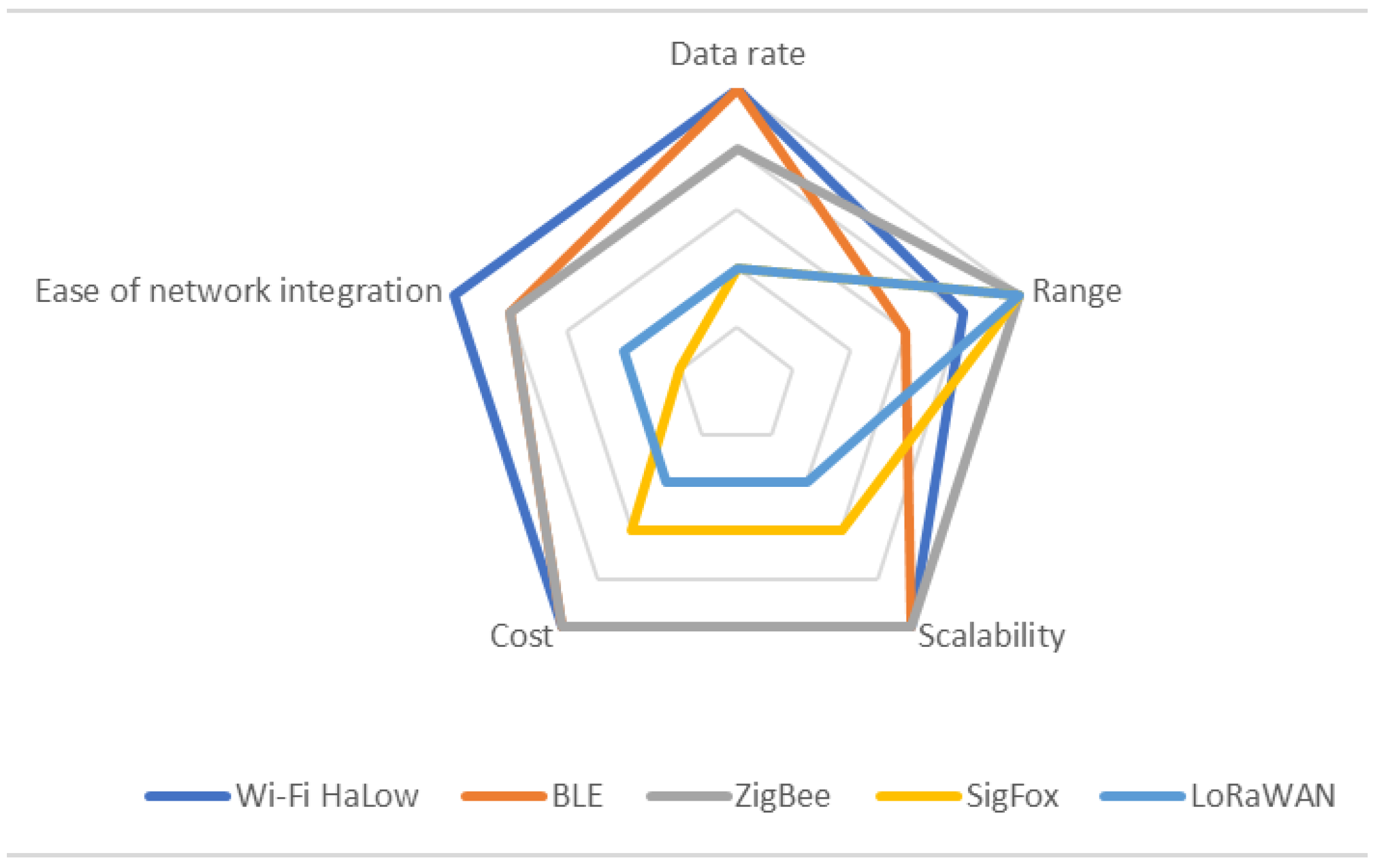
2.1. Communication between Sensors and Relays

In order to establish communication links between sensors in a subnetwork to coordinator devices or even to base stations located within a short range of the sensors, several low-power communication protocols can be implemented. Some of them are discussed in the following paragraphs, followed by a highlight and comparison of their key parameters in Figure 1 and Table 1.

2.1.1. WiFi HaLow

A Wireless Local Area Network (WLAN-IEEE 802.11) is adequate for monitoring and data acquisition applications. It boasts a built-in roaming functionality that is useful for applications with moving devices [9]. In the 2.4 GHz band, a WLAN achieves a range of 200 m (and up to 500 m in free line of sight). In the 5 GHz band (IEEE 802.11a), this value comes down to around 50 m. A WLAN allows for high data throughput, but power consumption is also considerable [9].
Wi-Fi HaLow (IEEE 802.11.ah) was developed considering the necessity of low-power modules with low data throughput, such as the ones used in most MIoT applications. It operates in the sub-GHz RF spectrum region, which offers less attenuation over distance and with obstacles than 2.4 or 5 GHz frequencies. Consequently, it can provide significantly higher working ranges, connecting devices approximately 1 km away from the access point. Additionally, power-saving features allow for multiyear battery operation [10].
A Wi-Fi HaLow network is compatible with existing Wi-Fi networks without a loss of RF performance on either side, i.e., it can be deployed with existing wireless networks already in place [10].
The IEEE 802.11ah standard defines data rates that range from 150 kbps (at a 1 km range) to 86 Mbps and supports up to 8191 devices per SSID, making Wi-Fi HaLow suited for a wide variety of applications with a multitude of different requirements [10,11].

2.1.2. Bluetooth Low Energy

According to Bluetooth Special Interest Group (SIG), around 40 billion Bluetooth devices are expected to be operating in 2021. The main driver of the latest growth in Bluetooth adoption is the IoT [12]. It operates in the ISM band of 2.4 GHz (therefore, it is shared with other applications such as WLANs, microwave ovens, and medical devices) [12].
To improve upon Bluetooth’s power consumption figure, Bluetooth Low Energy was created. This is achieved by having a device inactive most of the time (over 99% of it). With this, battery lifespans on the order of magnitude of the year are possible, albeit with low data rates being achieved [12]. The range of BLE is around 100 m [10] and the achievable data rate at that range is 125 kbps [10].

2.1.3. ZigBee

ZigBee is based on the IEEE 802.15.4 standard with additional routing and networking functionality [13], such as meshing. Mesh networking is particularly useful in applications where the range between two devices may be too large but an intermediate device in the range of both could forward the message [13].
In Europe, it uses the frequency bands of 868 MHz and 2.4 GHz (ISM). In the 2.4 GHz band, the theoretical maximum data rate is around 125 kbps [13]. In the sub-GHz band, the data rate drops to 20 kbps [14].
The ZigBee protocol is designed so that the radios automatically form a network after deployment without user intervention. The protocol also manages retries, acknowledgements, and message routing. Additionally, it can also self-heal the network [13].
ZigBee was developed keeping battery life in mind, and consequently devices can operate on a battery for years. Additionally, ranges of over 100 m can be achieved [13], with some manufacturers claiming theoretical rural and urban line-of-sight ranges up to 14.5 km and 2.5 km, respectively, with data rates of 10 kbps [15].

2.1.4. SigFox

SigFox operates in the 868 MHz band (ISM) and provides a simple way to connect low-energy isolated modules to customer applications at a low cost. Connected devices can transmit messages with payloads of 1 to 12 bytes and are limited to a maximum of 140 messages per day, with data rates of 100 bps [16].
SigFox uses Ultra Narrow Band signals with duty cycles in Europe, and it has a maximum radiated power of 14 dBm per device [16].
In order to save power and maximize battery life, the radio is only turned on when there is a message to transmit. Consequently, the radio operates for a few seconds every day, leading to battery lives of several years [16]. However, if a device needs to be reached by the network, it can only be done after an uplink (the device waits for 20 to 30 s after an uplink) [16].
SigFox achieves ranges of up to 10 km in urban environments and 40 km in rural environments [17].

2.1.5. LoRaWAN

LoRaWAN is a Low-Power WAN (LPWAN) that is optimized for low power consumption and designed to support networks of millions of devices. It supports low-cost bidirectional communication. Devices using LoRaWAN have power consumptions low enough to be used in conjunction with power harvesting technologies [18].
LoRaWAN Class A nodes achieve maximum ranges of up to 15 km or a maximum data rate of 21.9 kbps, or a balance of each as required [19]. For the maximum range, a data rate of 250 bps can be achieved [20].
It has a star-topology network, with a gateway that is connected to many nodes and concentrates all their activity [19]. It operates in the 868 MHz ISM band and has a maximum radio power of 14 dBm [21].
Table 1. Description of wireless communication protocols used for data transmission between sensors and relays.
AttributesWi-Fi HaLowBLEZigBeeSigFoxLoRaWAN
Data Rate 1150 kbps125 kbps10 kbps100 bps250 bps
Range1 km100 m14.5 km10 km15 km
Battery life [10]YearsYearsYearsYearsYears
Network topology [10]StarP2PMeshStarStar
StandardIEEE 802.11ahBluetooth SIGIEEE 802.15.4ProprietaryProprietary
Subscription-based [10]NoNoNoYesYes
1 Values for highest range.
Figure 1. Comparison of the performance of each communication protocol in key parameters. Data obtained in Ref [11] 2021, Wi-Fi CERTIFIED HaLow™.
Applsci 12 06439 g001
The technical specifications provided by the manufacturers and developers of the aforementioned protocols are, naturally, related to terrestrial communications. This environment presents challenges to wireless communications such as signal losses and multipath propagation due to the presence of obstacles. Nevertheless, the ocean environment is even more hostile to wireless communications over long distances. Line-of-sight loss due to the earth’s curvature or undulation, signal reflection on the water’s surface, and rough weather conditions are some examples of maritime environment hindrances that can cause the technical specifications provided by manufacturers to be inaccurate in the ocean.
Considering the protocols above and Table 1 and Figure 1, it appears that ZigBee is more suited for applications in the ocean. A mesh-type topology becomes advantageous as it helps guarantee, through multihopping, that the data payloads from all the sensors reach the coordinator or the base station even if two nodes lose lines of sight, which may happen due to the presence of an obstacle or waves. Considering as well that it requires no subscription, network integration is easy, and the cost is low, it is at the very least a technology that must be seriously considered, as long as the achievable data rate is sufficient for the desired application.

2.2. Communication to On-Shore Base Station

In a remote ocean monitoring application, data may have to be sent to an onshore base station for collection, processing, and decision making. The data from many sensor nodes may have been collected by a coordinator, or each of the sensor nodes may send the data directly to the base station, depending on the application. In any of the cases, a long-range wireless communication method is required, of which there are several available for use, each with its pros and cons.
Common long-range wireless communication methods are highlighted in Table 2. As expected, those that rely on terrestrial infrastructures, such as LTE and GSM, provide the lowest ranges. Additionally, depending on the amount of data to be transferred, these can become expensive. Using a radio link in the VHF frequency range can deliver data at a long distance, but the data rate is very limited, and the transmission antennas’ size can be cumbersome and even restrictive in some applications, especially considering that line of sight is restricted by the earth’s curvature at long distances, thus requiring high communication towers that may be too expensive or difficult to build [22]. Long-range Wi-Fi consists of the use of the standard Wi-Fi protocol but relies on directive antennas, amplifiers, and more sensitive receivers to increase the achievable range and create a point-to-point connection.
Satellite communication is also possible. Digital amateur radio communication is a feasible alternative for a low rate and small data package exchange. An Automatic Packet Reporting System (APRS) is a two-way packet communication protocol for real-time communication, using low-Earth orbit or geostationary satellites to interconnect local networks. It is mainly used for location reporting, weather station telemetry, text messages, and danger reports. With a data rate of 1200 bps and a frequency around the 2 m amateur band, it is a reliable and low-power data transfer solution for long-range applications. Global coverage is assured by the many amateur radio transponders sent to space aboard satellites, such as the International Space Station and recently the Es’hail 2, the first geostationary satellite with an integrated amateur radio transponder. The main disadvantages of this choice are the large equipment required, mainly the antenna, which may limit its deployment to fixed structures such as offshore wind turbines or oil platforms, the low data rate, and the requirement of an amateur radio license to be operated. The Iridium satellite network consists of 66 satellites that orbit 780 km above the Earth and provide worldwide coverage [23]. In order to communicate through the iridium network, transceivers such as Iridium Core 9523 [24] and Iridium 9602 [25] can be used. Unfortunately, the cost of this implementation can also be high, but it is the only available solution for remote applications.
An alternative to Iridium, called the Starlink, is currently being deployed. It is planned to consist of over 42,000 satellites at an orbit of 550 km. As of January 2022, more than 1900 Starlink satellites have been launched, with download speeds around 100 Mbps and latencies as low as 20 ms [26].
Table 2. Reported data rate and range performance of long-range communication protocols.
Data RateRange
VHF [7]1.2 kbps120 km
Long-range Wi-Fi [7]3 Mbps20–50 km
LTE [7]7.6 Mbps10 km
GSM/GPRS [27]168 kpbs2–35 km
Iridium [23]176–704 kbpsworldwide
Starlink [28]100+ Mbpsworldwide (expected)
From the analysis of the technologies presented here and in Table 2, it is possible to conclude that when the coordinator that needs to transfer data is near the shore, LTE or long-range Wi-Fi can be used, as they allow high data rates, although for shorter ranges, as seen in [29,30]. GSM can also be employed in that scenario, but only if the required data rate is low [31]. For truly remote devices, VHF is a possible solution for low-data-rate applications, despite the possible technical difficulties caused by the size of the required antennas. Consequently, satellite-based communications such as the Iridium network [32] and eventually Starlink appear to be the best available solutions, despite the high costs involved.
As previously mentioned, data from sensor nodes can either be sent to a coordinator which then relays it to the onshore main station or the sensor node can send it directly to the main station. These approaches need to be considered bearing in mind the use case. For example, if the sensor node is close to the shoreline or it is employed in a network with coordinator modules, data communication can be achieved with protocols such as LR Wi-Fi. On the contrary, when the sensor node is truly remote, satellite communication will need to be employed, at the cost of high energy expenditure and, consequently, a smaller lifetime of the sensor. Therefore, it is advisable, when applicable, to have several sensor nodes communicate with a coordinator node through low energy expenditure protocols and gift the coordinator with a larger battery and an energy harvesting module, such as a solar panel, to extend the lifetime of all the sensors.

2.3. Long-Range, No-Line-of-Sight Communication

An interesting phenomenon that can be utilized to achieve long-distance and no-line-of-sight communication using communication protocols in the GHz frequency range, such as Wi-Fi or Bluetooth, is the evaporation duct. Under the appropriate conditions, a region of rapidly decreasing humidity appears above the ocean, which causes RF signals to be trapped in this layer and act similarly to a waveguide [22], leading to less attenuation of the signal over distance and allowing non-line-of-sight communication, as illustrated in Figure 2.
The bibliography has some examples that demonstrate the feasibility of utilizing the evaporation duct. For example, in [22], the authors report a range of 78 km when using a frequency of 10.6 GHz, which could allow a large bandwidth to be used to transfer data (10 Mbps were reported). In [33], a range of 64 km was achieved with a 10.4 GHz signal. In [34], it is numerically demonstrated that frequencies in the range of 10–12 GHz have the smallest propagation losses over a 100 km distance in the evaporation duct, using a fixed antenna height, with losses increasing for higher frequencies. According to the same study, a 5.8 GHz carrier is also better than a 2.4 GHz one; therefore, using 5.8 GHz Wi-Fi combined with the evaporation duct seems a viable option to extend the communication range, although such a system is highly dependent on atmospheric conditions.

3. Examples of Maritime Internet of Things Networks in Applications

The bibliography contains several examples of wireless sensor networks applied to the ocean where wireless communications are employed. Some notorious examples are briefly highlighted in the following paragraphs, and Table 3 presents a summary of the literature review regarding communication technologies and the intended implementation of the prototype.
Water quality monitoring is one application where the MIoT has been significantly employed. Examples of employments of wireless communications for this purpose are found in [4], in which the authors use GSM and the 2.4 GHz ISM band to transfer data from sensors to on-shore data centers. A similar approach was reported in [41], with the use of 3G. In [39], the authors use a ZigBee-enabled sensor network to monitor water quality in a river. The data generated by the sensors are aggregated in a central node via Zigbee and they are then relayed to a base station via Wi-Fi or 4G. Similar approaches are used in [46] (Zigbee and 3G) and in [47], where Wi-Fi or LoraWAN are used for short-range communication to a gateway which then uses long-range Wi-Fi for long-distance communication to a central station. Finally, in [50], Zigbee is used for short-range communication to a WiMAX gateway that relays the data to the shore.
Water quality monitoring is also extremely important in aquaculture, and some examples of wireless sensor networks employed in this field are reported in the bibliography. Due to the shorter ranges involved in this application, direct communication from sensors to a central station is preferred, with Wi-Fi [36] and LoRaWAN [40] being employed.
In [38], a marine monitoring network implemented in the Caspian Sea is reported. The network comprises shallow and deep-water measuring devices, coastal monitoring devices, and central data stations. From shallow water to the data stations, data are transferred via a cable. On-shore and deep-water data are transferred via satellite.
In [5,35], the authors detail a coastal oceanographic observation system to monitor the physical environment of the Mar Menor and its interaction with the Mediterranean Sea. The authors aim to monitor parameters such as water pressure, current velocity, water temperature, turbidity and salinity, and the presence of chlorophyll, among others. The system is composed of three clusters of sensors, where each cluster has a coordinator that collects data from the sensors via ZigBee. The coordinator node then transfers said data to a base station via a GPRS connection. There is also another node, isolated from the clusters, which communicates directly to the base station via GPRS.
Fishery buoys floating on the ocean serve as a visual indication to fishermen of where their traps are located. Finding these buoys is performed with the naked eye and is made extremely difficult by adverse weather conditions and poor visibility. Consequently, in [44], the authors propose to facilitate this task by implementing a GPS locator in the buoys and relaying its location to the fishing vessel via a LoRaWAN connection. With the naked eye, fishermen can detect buoys at around 3 km. With the proposed system, the buoy can be reliably located 14 km away.
The bibliography also contains several examples of proof-of-concept MIoT architectures, where varied wireless communication technologies are employed. In [48], the potential of 5G technology is demonstrated by the authors, who achieved a 1 Gbps data rate link from devices 1 km away from the shore through the use of a mobile 5G station on a ship. In [31], the authors test the use of several buoys interconnected via Zigbee which then have a coordinator that relays data via GSM to a coastal station. A flying wireless router approach is proposed in [45], where tethered balloons establish air-to-surface links via LTE and air-to-air (balloon-to-balloon) long-range communication via IEEE 802.11g protocol, relaying data from the surface to shore. A maritime LTE network is proposed in [30], with long-range and high-data-rate, ship-to-shore and ship-to-ship communication and the use of LTE routers in ships. A maritime wireless mesh network with the 802.16 protocol at 5.8 GHz is proposed in [49], and the use of 5.8 GHz 802.11 protocol is demonstrated in [51] to allow the establishment of a point-to-point (fishing ship to shore) 7 km link at 1 Mbps.
The Iridium satellite network is also employed in [32] with data reception rates of 98.7%, demonstrating the reliability of this approach. Finally, non-RF communication technologies are also proposed in the bibliography, such as in [42], albeit in an embryonic state, as only simulations are presented.
From the analysis of Table 3 and its discussion, it becomes clear that Zigbee is the protocol with the most adoption and potential for short-range communication between sensors and a central node, which coincides with the conclusion of Section 2.1, where Zigbee was singled out as a technology with significant strengths for employment in the ocean, of which mesh networking is key, and it is expected that it will be adopted more and more in upcoming years. In terms of long-range communications to the shore, the conclusions of Section 2.2 also hold up when the state of the art is analyzed. LTE is employed multiple times in the discussed works for shorter communication ranges, with LR Wi-Fi being used for longer ranges. Satellite networks are also employed with great results, and it is expected that the Starlink network will improve further upon the Iridium network, which is already deployed and operational.

4. Architecture of the Maritime Internet of Things

The MIoT has the potential to be a game changer in fields such as water quality monitoring, fishery, aquaculture, and vessel communication [5,36,44,47]. Due to the heterogeneity of possible applications, the types of data sent in an MIoT network can greatly vary. For example, in weather monitoring systems, several variables can be monitored, such as air temperature and pressure, wind speed and direction, and relative humidity, among others. In water quality monitoring, water temperature and salinity are important factors, along with measurements of chlorophyll, nitrates, phosphates, and so on [52]. Data from these applications must then be relayed to a base station for processing and analysis. In fishery, the GPS coordinates of fishing buoys are used to allow fishermen to locate their buoys more accurately and efficiently [44].
As illustrated above, the MIoT must be capable of dealing with data from many different sources and direct it either to shore or vessels. Considering, for example, an application where we want to monitor several parameters of water quality, we can define an adequate architecture for an MIoT that reliably collects data from many sensors and sends it to base stations onshore for storage and processing.
The sensor nodes should comprise four modules: power, sensing, processing, and wireless communications [52]. The first can be a battery, or an energy harvester, or a combination of both for an extended lifetime. The processing unit controls the entire node, collects data from the sensors and directs them to the wireless communication module, which then relays the information in the network until it reaches the base station (onshore or on a vessel).
Wireless communications can be employed in several technologies, such as ZigBee, Bluetooth, Wi-Fi, and GPRS, among others. Nevertheless, as it is envisioned that many sensor nodes may be required for high-spatial-resolution monitoring, that their lifetime should be extended for as long as possible, and that the cost of operation should be minimized, shorter-range and low-power communication protocols such as ZigBee are desired. With this technology, the sensor nodes can create a mesh network for increased communication reliability and range through multihopping. To maximize sensor lifetime, all data can be aggregated in a central node, called a coordinator, which is composed of three modules—power, processing, and wireless communications—where the latter has a ZigBee module to receive data from the sensor nodes and a long-range communication method to relay the data to a base station, which can be through satellite communication or GPRS, for example. This way, it is possible to create several independent clusters of sensors, or subnetworks, to ensure a low-cost and high-resolution monitoring [5].
From the conclusions drawn in this work, we propose the hypothetical implementation of a wireless communication network presented in Figure 3 that is suitable for monitoring, for example, water quality parameters over a large ocean area. This proposed network uses a short-range wireless communication protocol such as Zigbee to aggregate sensor data from shallow- and deep-water monitoring systems in monitoring stations, which then relay these data to a collecting station via a long-range protocol, for example, LR Wi-Fi or via satellites.

5. Conclusions

The importance of services related to safety and security, environmental protection, and research at sea is well documented and, consequently, numerous efforts have been made by researchers in the past years to deploy reliable MIoT networks at sea. Many sensor nodes are required for high-spatial-resolution monitoring, their lifetime should be extended for as long as possible, and the cost of operation should be minimized. As such, the predominant use of shorter-range and low-power communication protocols is desired. All data can be aggregated in a central node, called a coordinator, which is composed of three modules—power, processing, and wireless communications—where the latter has a short-range module to receive data from the sensor nodes and a long-range communication method to relay the data to a base station, which can be through satellite communication or GPRS, for example. This way, it is possible to create several independent clusters of sensors, or subnetworks, to ensure a low-cost and high-resolution monitoring.
From the review, it is possible to conclude that short-range communications can be established using ZigBee, as it is well suited for applications in the ocean due to its mesh-type topology and the robustness that it adds to the network in an environment where the loss of line of sight is expected. Additionally, it requires no subscription, network integration is easy, and the cost is low. In terms of long-range communication, it is possible to conclude that LTE or long-range Wi-Fi are adequate for use when the coordinator that needs to transfer data is near the shore. For truly remote devices, the Iridium network and eventually Starlink appear to be the best available solutions, despite the high costs involved.

Funding

This work is cofunded by the project K2D: Knowledge and Data from the Deep to Space with reference POCI-01-0247-FEDER-045941, cofinanced by the European Regional Development Fund (ERDF), through the Operational Program for Competitiveness and Internationalization (COMPETE2020), and by the Portuguese Foundation for Science and Technology (FCT) under the MIT Portugal Program. This work is also cofinanced by national funds through FCT–Fundação para a Ciência e Tecnologia, I.P., under project SONDA (PTDC/EME-SIS/1960/2020). T.M. thanks FCT for grant SFRH/BD/145070/2019.

Institutional Review Board Statement

Not applicable.

Informed Consent Statement

Not applicable.

Data Availability Statement

Not applicable.

Conflicts of Interest

The authors declare no conflict of interest.

References

  1. Huo, Y.; Dong, X.; Beatty, S. Cellular Communications in Ocean Waves for Maritime Internet of Things. IEEE Internet Things J. 2020, 7, 9965–9979. [Google Scholar] [CrossRef] [Green Version]
  2. Faria, C.L.; Goncalves, L.M.; Martins, M.S.; Lima, R. Energy Harvesting to Increase the Autonomy of Moored Oceanographic Monitoring Stations. In Proceedings of the 2018 OCEANSMTS/IEEE Kobe Techno-Oceans (OTO), Kobe, Japan, 28–31 May 2018; pp. 1–5. [Google Scholar]
  3. Matos, T.; Faria, C.L.L.; Martins, M.S.S.; Henriques, R.; Gomes, P.A.A.; Goncalves, L.M.M. Development of a Cost-Effective Optical Sensor for Continuous Monitoring of Turbidity and Suspended Particulate Matter in Marine Environment. Sensors 2019, 19, 4439. [Google Scholar] [CrossRef] [PubMed] [Green Version]
  4. Adamo, F.; Attivissimo, F.; Carducci, C.G.C.; Adamo, L. Erratum: A Smart Sensor Network for Sea Water Quality Monitoring (IEEE Sensors Journal). IEEE Sens. J. 2016, 16, 855. [Google Scholar] [CrossRef]
  5. Albaladejo Perez, C.; Soto Valles, F.; Torres Sanchez, R.; Jimenez Buendia, M.; Lopez-Castejon, F.; Gilabert Cervera, J. Design and Deployment of a Wireless Sensor Network for the Mar Menor Coastal Observation System. IEEE J. Ocean. Eng. 2017, 42, 966–976. [Google Scholar] [CrossRef]
  6. Martins, M.S.S.; Barardo, C.; Matos, T.; Goncalves, L.M.M.; Cabral, J.; Silva, A.; Jesus, S.M.M. High Frequency Wide Beam PVDF Ultrasonic Projector for Underwater Communications. In Proceedings of the OCEANS 2017, Aberdeen, UK, 19–22 June 2017; pp. 1–5. [Google Scholar] [CrossRef]
  7. Chen, W.; Li, C.; Yu, J.; Zhang, J.; Chang, F. A Survey of Maritime Communications: From the Wireless Channel Measurements and Modeling Perspective. Reg. Stud. Mar. Sci. 2021, 48, 102031. [Google Scholar] [CrossRef]
  8. Yang, T.; Chen, J.; Zhang, N. AI-Empowered Maritime Internet of Things: A Parallel-Network-Driven Approach. IEEE Netw. 2020, 34, 54–59. [Google Scholar] [CrossRef]
  9. HMS Industrial Networks. Wireless Technologies for Industrial Communication; HMS Industrial Networks AB: Halmstad, Sweden.
  10. WiFi Alliance Wi-Fi HaLowTM: Wi-Fi® for IoT Applications. 2020. Available online: https://www.wi-fi.org/downloads-registered-guest/Wi-Fi_HaLow_White_Paper_20200518_0.pdf/36881 (accessed on 29 June 2021).
  11. WiFi Alliance Wi-Fi HaLowTM Technology Overview. Available online: https://www.wi-fi.org/downloads-registered-guest/Wi-Fi_CERTIFIED_HaLow_Technology_Overview_20211102.pdf/36879 (accessed on 29 June 2021).
  12. Rohde & Schzwarz From Cable Replacement to the IoT Bluetooth 5 White Paper. Available online: https://cdn.rohde-schwarz.com/pws/dl_downloads/dl_application/application_notes%5C%5C/1ma108/1MA108_3e_Bluetooth_WhitePaper%5C~1.pdf. (accessed on 21 June 2021).
  13. Digi International Demystifying 802.15.4 and ZigBee. Available online: http://www.mouser.com/pdfdocs/digi-wp_zigbee.pdf (accessed on 21 June 2021).
  14. Zigbee Protocol. Available online: https://www.sciencedirect.com/topics/engineering/zigbee-protocol (accessed on 29 June 2021).
  15. Digi DIGI XBEE SX 868. Available online: https://www.digi.com/products/embedded-systems/digi-xbee/rf-modules/sub-1-ghz-rf-modules/digi-xbee-sx-868 (accessed on 21 June 2021).
  16. Sigfox ETSI Mode White Paper. Available online: https://support.sigfox.com/docs/sigfox-device-etsi-mode-white-paper (accessed on 21 June 2021).
  17. Mekki, K.; Bajic, E.; Chaxel, F.; Meyer, F. A Comparative Study of LPWAN Technologies for Large-Scale IoT Deployment. ICT Express 2019, 5, 1–7. [Google Scholar] [CrossRef]
  18. LoRa Alliance LoRaWAN Security–Full End-to-End Encryption for IoT Application Providers. Available online: https://pages.services/pages.lora-alliance.org/lorawan-security/ (accessed on 21 June 2021).
  19. Laird. Sentrius Series; Laird: London, UK, 2020. [Google Scholar]
  20. Lavric, A.; Popa, V. Performance Evaluation of LoRaWAN Communication Scalability in Large-Scale Wireless Sensor Networks. Wirel. Commun. Mob. Comput. 2018, 2018, 6730719. [Google Scholar] [CrossRef] [Green Version]
  21. LoRa Alliance A Technical Overview of LoRa ® and LoRaWANTM. Available online: https://lora-alliance.org/resource-hub/what-lorawantm (accessed on 21 June 2021).
  22. Woods, G.S.; Ruxton, A.; Huddlestone-Holmes, C.; Gigan, G. High-Capacity, Long-Range, Over Ocean Microwave Link Using the Evaporation Duct. IEEE J. Ocean. Eng. 2009, 34, 323–330. [Google Scholar] [CrossRef]
  23. Iridium Iridium Network. Available online: https://www.iridium.com/network/ (accessed on 1 July 2021).
  24. Iridium Iridium Core 9523. Available online: https://www.iridium.com/products/iridium-core-9523/ (accessed on 1 July 2021).
  25. Iridium Iridium 9602. Available online: https://www.iridium.com/products/iridium-9602/ (accessed on 1 July 2021).
  26. Mann, A.; Pultarova, T. Starlink: SpaceX’s Satellite Internet Project. Available online: https://www.space.com/spacex-starlink-satellites.html (accessed on 4 February 2022).
  27. Saad, C.; Mostafa, B.; Ahmadi, E.; Abderrahmane, H. Comparative Performance Analysis of Wireless Communication Protocols for Intelligent Sensors and Their Applications. Int. J. Adv. Comput. Sci. Appl. 2014, 5, 76–85. [Google Scholar] [CrossRef] [Green Version]
  28. McKetta, I. Starlink Expands but Q3 2021 Performance Flattens in Some Areas. Available online: https://www.speedtest.net/insights/blog/starlink-hughesnet-viasat-performance-q3-2021/ (accessed on 4 February 2022).
  29. Zainuddin, Z.; Wardi; Nantan, Y. Applying Maritime Wireless Communication to Support Vessel Monitoring. In Proceedings of the 2017 4th International Conference on Information Technology, Computer, and Electrical Engineering (ICITACEE), Semarang, Indonesia, 18–19 October 2017; pp. 158–161. [Google Scholar] [CrossRef]
  30. Jo, S.W.; Shim, W.S. LTE-Maritime: High-Speed Maritime Wireless Communication Based on LTE Technology. IEEE Access 2019, 7, 53172–53181. [Google Scholar] [CrossRef]
  31. Gricius, G.; Drungilas, D.; Andziulis, A.; Dzemydiene, D.; Voznak, M.; Kurmis, M.; Jakovlev, S. Advanced Approach of Multiagent Based Buoy Communication. Sci. World J. 2015, 2015, 569841. [Google Scholar] [CrossRef] [PubMed] [Green Version]
  32. Yu, F.; Sun, J. Integrated Marine Environment Observation System Based on Iridium Satellite Communication. In Lecture Notes in Electrical Engineering; Springer: Singapore, 2021; Volume 706, pp. 126–134. ISBN 9789811584572. [Google Scholar]
  33. Zaidi, K.S.; Jeoti, V.; Iqbal, A.; Awang, A. Feasibility of Trans-Horizon, High-Capacity Maritime Wireless Backhaul Communication Link. In Proceedings of the 2014 5th International Conference on Intelligent and Advanced Systems (ICIAS), Kuala Lumpur, Malaysia, 3–5 June 2014; pp. 2–7. [Google Scholar] [CrossRef]
  34. Iqbal, A.; Jeoti, V. Feasibility Study of Radio Links Using Evaporation Duct over Sea off Malaysian Shores. In Proceedings of the 2010 International Conference on Intelligent and Advanced Systems, Kuala Lumpur, Malaysia, 15–17 June 2010; Volume 10, pp. 2–6. [Google Scholar] [CrossRef]
  35. Pérez, C.A.; Jimenéz, M.; Soto, F.; Torres, R.; López, J.A.; Iborra, A. A System for Monitoring Marine Environments Based on Wireless Sensor Networks. In Proceedings of the OCEANS 2011 IEEE—Spain, Santander, Spain, 6–9 June 2011; pp. 1–6. [Google Scholar] [CrossRef]
  36. Zhu, X.; Li, D.; He, D.; Wang, J.; Ma, D.; Li, F. A Remote Wireless System for Water Quality Online Monitoring in Intensive Fish Culture. Comput. Electron. Agric. 2010, 71, S3. [Google Scholar] [CrossRef]
  37. Wang, J.; Ren, X.; Shen, Y.; Liu, S. A Remote Wireless Sensor Networks for Water Quality Monitoring. In Proceedings of the 2010 International Conference on Innovative Computing and Communication and 2010 Asia-Pacific Conference on Information Technology and Ocean Engineering, Macao, China, 30–31 January 2010; pp. 7–12. [Google Scholar]
  38. Najafi-Jilani, A.; Nik-Khah, A. Development of Integrated Marine Monitoring Network on Southern Coastline of Caspian Sea. Int. J. Nav. Archit. Ocean Eng. 2011, 3, 136–140. [Google Scholar] [CrossRef] [Green Version]
  39. Menon, G.S.; Ramesh, M.V.; Divya, P. A Low Cost Wireless Sensor Network for Water Quality Monitoring in Natural Water Bodies. In Proceedings of the 2017 IEEE Global Humanitarian Technology Conference (GHTC), San Jose, CA, USA, 19–22 October 2017; pp. 1–8. [Google Scholar] [CrossRef]
  40. Lu, H.; Cheng, C.; Cheng, S.; Lo, W.; Cheng, Y.; Nan, F.; Chang, S. A Low-Cost Buoy System with Artificial Intelligence (AI) for Offshore Aquaculture. In Proceedings of the 2021 International Symposium on Intelligent Signal Processing and Communication Systems (ISPACS), Hualien City, Taiwan, 16–19 November 2021; pp. 2021–2022. [Google Scholar]
  41. Kageyama, T.; Miura, M.; Maeda, A.; Mori, A.; Lee, S.S. A Wireless Sensor Network Platform for Water Quality Monitoring. In Proceedings of the 2016 IEEE Sensors, Orlando, FL, USA, 30 October–3 November 2016; pp. 31–33. [Google Scholar] [CrossRef]
  42. Kim, H.; Sewaiwar, A.; Chung, Y. Maritime Visible Light Communication with Sea Spectrum Models. Int. J. Commun. 2015, 9, 67–70. [Google Scholar]
  43. Cho, H.; Yu, S.C. Performance Evaluation of a Long-Range Marine Communication System for Fishing Buoy Detection. In Proceedings of the 2019 IEEE Underwater Technology (UT), Kaohsiung, Taiwan, 16–19 April 2019. [Google Scholar] [CrossRef]
  44. Cho, H.; Yu, S.C. Development of a Long-Range Marine Communication System for Fishery Buoy Searching. In Proceedings of the OCEANS 2018 MTS/IEEE Charleston, Charleston, SC, USA, 22–25 October 2018; pp. 8–12. [Google Scholar] [CrossRef]
  45. Teixeira, F.B.; Oliveira, T.; Lopes, M.; Leocádio, C.; Salazar, P.; Ruela, J.; Campos, R.; Ricardo, M. Enabling Broadband Internet Access Offshore Using Tethered Balloons: The BLUECOM+ Experience. In Proceedings of the OCEANS 2017—Aberdeen, Aberdeen, UK, 19–22 June 2017; pp. 1–7. [Google Scholar] [CrossRef] [Green Version]
  46. Kageyama, T.; Miura, M.; Maeda, A.; Mori, A.; Lee, S.S. Improvement of the Sensor Node for Wireless Sensor Network System to Monitor Natural Water Quality. In Proceedings of the 2018 IEEE 13th Annual International Conference on Nano/Micro Engineered and Molecular Systems (NEMS), Singapore, 22–26 April 2018; pp. 553–556. [Google Scholar] [CrossRef]
  47. Song, Y.; Shin, H.; Koo, S.; Baek, S.; Seo, J.; Kang, H.; Kim, Y. Internet of Maritime Things Platform for Remote Marine Water Quality Monitoring. IEEE Internet Things J. 2021, 4662, 1–13. [Google Scholar] [CrossRef]
  48. Mashino, J.; Tateishi, K.; Muraoka, K.; Kurita, D.; Suyama, S.; Kishiyama, Y. Maritime 5G Experiment in Windsurfing World Cup by Using 28 GHz Band Massive MIMO. In Proceedings of the 2018 IEEE 29th Annual International Symposium on Personal, Indoor and Mobile Radio Communications (PIMRC), Bologna, Italy, 9–12 September 2018; pp. 1134–1135. [Google Scholar] [CrossRef]
  49. Zhou, M.; Hoang, V.; Harada, H.; Pathmasuntharam, J.; Wang, H.; Kong, P.; Ang, C.; Ge, Y.; Wen, S. TRITON: High-Speed Maritime Wireless Mesh Network. IEEE Wirel. Commun. 2013, 20, 134–142. [Google Scholar] [CrossRef]
  50. Silva, S.; Nguyen, H.N.; Tiporlini, V.; Alameh, K. Web Based Water Quality Monitoring with Sensor Network: Employing ZigBee and WiMax Technologies. In Proceedings of the 8th International Conference on High-capacity Optical Networks and Emerging Technologies, Riyadh, Saudi Arabia, 19–21 December 2011; pp. 138–142. [Google Scholar] [CrossRef]
  51. Lopes, M.J.; Teixeira, F.; Mamede, J.B.; Campos, R. Wi-Fi Broadband Maritime Communications Using 5.8 GHz Band. In Proceedings of the 2014 Underwater Communications and Networking (UComms), Sestri Levante, Italy, 3–5 September 2014; pp. 5–9. [Google Scholar] [CrossRef]
  52. Sendra, S.; Parra, L.; Lloret, J.; Jiménez, J.M. Oceanographic Multisensor Buoy Based on Low Cost Sensors for Posidonia Meadows Monitoring in Mediterranean Sea. J. Sens. 2015, 2015, 920168. [Google Scholar] [CrossRef] [Green Version]
Figure 2. Representation of the evaporation duct and its use in long-distance communications.
Applsci 12 06439 g002
Figure 3. Representation of a hypothetical wireless communication network for ocean water quality monitoring using both short- and long-range communication protocols.
Applsci 12 06439 g003
Table 3. Summary of the literature review in terms of the communication protocol implemented between nodes and coordinators and towards base stations (when applied) and the implementation of the prototypes.
ReferenceCommunicationImplementation
Nodes to CoordinatorTo Base Station
[4]GSM/2.4 GHz ISMField tests (Italy, Sea)
[5,35]ZigBeeGPRSField tests (Spain, Sea)
[29]LR Wi-FiField tests (Indonesia, Sea)
[30] LTEField tests (Korea, Sea)
[31]ZigbeeGSMField tests (Lithuania, Sea)
[32] IridiumField tests (China, Sea)
[36] Wi-FiField tests (aquaculture tanks)
[37]ZigBeeCDMAField tests (China, Lake)
[38]Satellite VHF/UHFWireField tests (Iran, Sea)
[39] LoRaWAN, 4G, Wi-Fi, ZigBeeField tests (India, River)
[40] LoRaWANLab tests
[41] 3GField test (Japan, Lake)
[42]VLC (visible light communication)Simulation
[43,44]LoRaWANField tests (Korea, Sea)
[45]IEEE 802.11a/g/n/ac and GPRS/LTEIEEE 802.11gField tests (Portugal, Ocean)
[46]ZigBee3GField tests (Japan, Lake)
[47] Wi-Fi/LoRaWANField tests (Korea, Sea)
[48]5GField tests (Japan, Sea)
[49] IEEE 802.16 (5.8 GHz)Field tests (Singapore, Sea)
[50]ZigBeeWiMaxLab tests (man-made lake)
[51] IEEE 802.11n (5.8 GHz)Field tests (Portugal, Sea)
Publisher’s Note: MDPI stays neutral with regard to jurisdictional claims in published maps and institutional affiliations.

