Article

The Integrated Assessment of Degraded Tourist Geomorphosites to Develop Sustainable Tourism: A Case Study of Grădina Zmeilor Geomorphosite, North-West Region, Romania

1
Faculty of Geography, Babes-Bolyai University, 400006 Cluj-Napoca, Romania
2
Cluj-Napoca Subsidiary Geography Section, Romanian Academy, 400015 Cluj-Napoca, Romania
3
Faculty of Civil Engineering, Technical University of Cluj-Napoca, 400020 Cluj-Napoca, Romania
*
Author to whom correspondence should be addressed.
Appl. Sci. 2022, 12(19), 9816; https://doi.org/10.3390/app12199816
Submission received: 8 August 2022 / Revised: 15 September 2022 / Accepted: 26 September 2022 / Published: 29 September 2022

Abstract

:
Most of the natural geomorphosites represent main attractions that have a high tourism potential and need great care in terms of their capitalization. The irrational tourism capitalization of the geomorphosites may lead to their degradation because of the lack of proper tourism infrastructure and the practice of random and uncontrolled tourism. The reintroduction in the tourism circuit of such geomorphological structures that have a high landscape and scientific value claims, first of all, the assessment of the current state of degradation and the drawing up of sustainable development proposals from a geomorphological point of view. This study deals mainly with the assessment of a geomorphosite (Grădina Zmeilor Geomorphosite, North-West Region, Romania), using a complex methodology, which is based on the identification of criteria influencing the tourism development of the geomorphosite, and their analysis by means of qualitative points given according to the impact of each criterion. A total of 17 criteria have been therefore identified. They are structured along four levels of analysis which are integrated in the form of spatial analysis based on weighted average, and highlight the overall value of the analysed geomorphosite. By implementing the methodology in the proposed research, a total value of 0.29 has been obtained in an interval between 0 and 1. This value underlines the high degree of degradation of the geomorphosite. The planning proposals have the main purpose of increasing the overall value of the geomorphosite by providing sustainability in its capitalization. To achieve this, proposals have been made to mitigate the shortcomings for a total of four criteria. The overall value of the geomorphosite has been recalculated, resulting a significant increase of the value (0.33), highlighting the impact of the implementation of these proposals in practice for the development of the geomorphosite and the increase of its level of tourism attractiveness. The introduction of this objective on the tourist map, following the application of the suggestions proposed in this paper, can lead to favorable economic development both at the local and regional level. This analysis model can also be applied to other geomorphists facing the problem of degradation and involution.

1. Introduction

The last two decades have seen numerous studies made to identify, list and assess the components of natural [1,2,3,4,5,6] and cultural heritage, to develop evaluation methods in accordance with the regional development policies, adequate for their implementation at the local level [7]. The issue related to geomorphosites, components of natural and cultural heritage, is defined at global level by the presence of several difficulties in their assessment, taking into account the complexity of local and regional development policies, which do not all agree on the presumably common purpose—the conservation and preservation of these natural and cultural heritage elements for future generations.
The development of qualitative and quantitative assessment methods, that should highlight the scientific, cultural, aesthetic and socio-economic values of the investigated element, together with the management and protection of the geomorphosites within a legal framework [8,9], should be the main reference points of future approaches. Their as-assessment by using inadequate methods, leading to an improper inventory [10], should not be present in the areas of interest of geomorphic research.
The research areas which provide sources of information for the understanding of the geology, history, and even the manner in which the site came into existence, are usually considered part of the cultural heritage, but they are under a growing risk of partial damage, mainly due to their lack of protection and to anthropogenic activities [11,12].
The components of cultural heritage and geotourism complete one another because they, taken together, lead to a proper development of the investigated area, given that the area is picturesque (visually attractive), rich (in terms of landscape elements) and diverse in natural and man-made resources [13]. Complex landscapes are those which stir high levels of interest, both from the point of view of the resources provided, and of the story conveyed [14].
The study of geosites/geomorphosites may represent a considerable resource in the promotion and development of tourism and geo-educational activities [15]. Their research may be important from an economic perspective because they are attractive, and are perceived as such either individually or at the group level. As a result, geosites/geomophosites determine an increase of the impact of tourism and lead to local or regional economic development [16,17,18,19,20,21].
Many geosites/geomorphosites that are important from a scientific point of view have limited access, either because there is no access infrastructure, it is not compliant with the norms, or there is a low interest from the local or regional community. The interest of these communities for local tourism resources should be promoted and included within the research, together with information regarding geological, geo-morphological, biological, and ecological aspects, which allow for a better understanding of the Earth’s geological history [22]. The research of geosites/geomorphosites is considered to be an important step in the process of identification and conservation of natural heritage [23], which has become more and more significant internationally in the latest 20 years [6,24].
The research of the elements which make up the natural environment highlights the geographical aspects that are present in the study area: climate [25], geology [26,27,28,29], and hydrology [30,31], and which have a strong impact on the development of landforms [1,5,32,33]. Landform components, individually or integrated within landscapes, play an important part in the development of tourism activities, and may generate vulnerabilities by means of the associated geomorphological processes, leading to important changes at the landform level [34,35,36,37,38].
In the last decade, the investigations regarding geosites/geomorphosites have used diverse quantitative and qualitative methods, according to ideas based on the conservation, protection and use of geological/geomorphological heritage. These studies propose criteria for the classification and characterization of the researched geological heritage [39,40], the assessment of geomorphosite scientific quality [41], the classification of geomorphological sites according to their tourism value [42], the parameters for the inventory and evaluation of the geomorphosites [43], the assessment of geomorphosites by means of scientific and additional parameters [44], and the analysis of intrinsic qualities, as well as the usefulness potential of the studied geomorphosite [1], as well as taking into consideration the possible threats and providing solutions for a better protection [45], techniques for geomorphosite assessment [9], a quantitative method used for the evaluation of geotopes, which can also be used for the sustainable management and the conservation of geological heritage within the study area [46,47].
Based on sets of criteria and indicators for determining values of the analysed site [48], the purpose of using these methods is to facilitate the site assessment, so that the re-searcher may easily determine the aspects provided by the analysed landform, and then may perform a ranking of the sites and place them according to the importance and priority they have within the processes of research, planning and protection [49,50].
Geomorphosites have been approached since the 1990s. In time, many definitions of the term geomorphosite have been provided. Strasser et al. [51] and Grandgirard [52,53,54] consider this term to be any geological form which receives subjective value from the perspective of the researcher, whether a scientific, aesthetic, cultural-historical or economic one. Panizza [55] considered that geomorphosites represent the geomorphological assets of geological heritage to which certain values may be attributed. Later, he provided another definition, stating that geomorphosites represent landforms that have peculiar and significant geomorphological features that qualify them to be components of cultural heritage [56,57]. Reynard [58] considers that the scientific value of the geomorphosite is the main value, while all the other types of values are secondary values. The total amount of values represents the global value of the geomorphosite. Serrano and Trueba [59] define this term as being an essential element within protected natural areas that should be assessed both for its scientific value, and for its social and economic impact.
Geosites, like geomorphosites, represent those landforms that constitute elements of scientific, cultural, economic, historical, and socio-cultural diversity, and on which quantitative and qualitative evaluations can be made [60].
Nature conservation has become a subject of scientific interest since the 1970s [60], while geodiversity conservation has become a strategy of global importance since the 1990s, especially after the first international symposium for the conservation of cultural heritage [61]. Geodiversity addresses aspects related to natural geological and geomorphological elements and soil features [62]. Conservation programs, well-known at the international and national levels (UNESCO Cultural Heritage, Natura 2000 Program) [63], encompass the protection of the entire natural habitat, defined by the geographical and ecological conditions of the environment [64,65].
The geological strata present interest in the assessment of geosites/geomorphosites due to changes occurring in time as a result of the actions of geomorphological processes on rocks, but also due to human intervention. Changes lead to the appearance of negative aspects (vulnerabilities) within the analysed landform, which may determine the destruction of the site (risk), unless stopped by measures taken by specialists [12].
The inappropriate use of geomorphosites, without taking into account the degree to which it can be exploited, can lead to the intense and defining degradation of the site, leading to its total or almost total destruction. On the other hand, if it is exploited consciously, taking into account the limits to which the site can be exploited, benefits and positive results can be obtained.
The risk associated with these vulnerabilities is assessed according to the composition of the geological bedrock (which may contain rocks prone to degradation). Conglomerates and sandstones are associated with a moderate-to-high risk. Examples in this sense are some geomorphosites in Talassemtane National Park in Morocco [66], as well as the Italian protected landforms developed on conglomerates and sandstones, researched by I. Bollati [67], or the Grădina Zmeilor (Dragons’ Garden) geomorphosite (Almaş catchment, Sălaj County).
The main objective of this study is to perform an analysis on the Grădina Zmeilor geomorphosite, to identify and assess the vulnerabilities and risks associated with both geomorphological processes and tourism activities, and to propose measures for the protection and planning of the geomorphosite.
The paper has in view the implementation of infrastructure management and development plans to stop territorial problems and the involvement of local communities to intensify tourism activities, to increase the tourism attractiveness of the region, and therefore increase the flow of tourism.

2. Materials and Methods
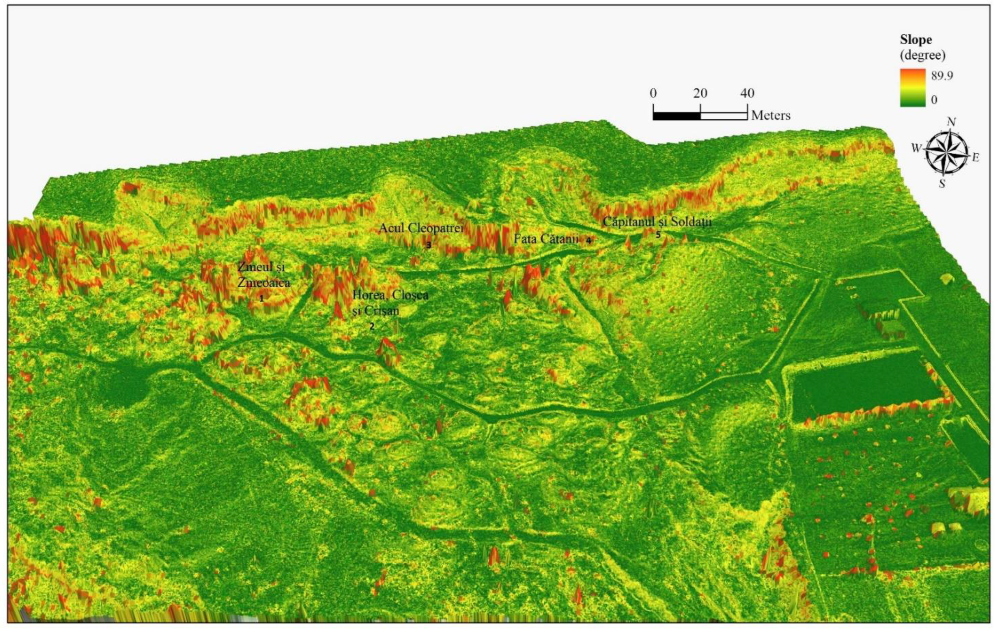
2.1. Study Area

The Grădina Zmeilor geomorphosite is a protected natural area (category IV of the IUCN) of the geological and landscape type, being located approximately 700 m from the DN 1G road, located in the western part of the village of Gâlgăul Almașului, in Bălan com-mune, Sălaj county. The central geographic coordinates of the area are 47°12′15″ latitude N and 23°17′50″ longitude E. This tourist objective is highly important from a geomorphological point of view, thanks to the geological substrate on which it is developed, namely on sandstones and conglomerates. The strata with sedimentary rocks, with a wide extension in the area, are included in the “Almașului Valley Group”, which includes the “Sânmihai Strata”, “Chechiş Strata”, “Hida Strata” and others, all these stratotypes having their description originate in Sălaj, on Almaşului Valley. The strata are slightly inclined to the southeast (8–10°) towards the center of the Transylvanian Depression.
As a result of the tectonic movements in the Neocene, fissures and diaclase occurred within the rock packs, showing an orientation in two directions, one NW–SE, and another NE–SW [29,68,69]. These cracks have played an important role in terms of the evolution of the relief within the researched objective. The rock layers present a high vulnerability to destructive geomorphological processes (mass movements), but anthropogenic activities also have a strong impact as well (tourism activities, educational programs, and school field trips). In this context, there is a low development of tourism and leisure activities within the site or near it, which leads to deficient capitalization of an important natural tourism resource.
The analysed geomorphosite is very important at the regional level, and the geomorphosite is located approximately in a central position within the North-West Development Region of Romania, administratively within Sălaj County and Bălan commune (Figure 1).
The location of the analysed geomorphosite (Figure 2), close to the main road axes of territorial development, the Cluj-Napoca-Zalău axis and Hida-Jibou secondary axis [70], determines its high importance from the point of view of tourism, given the relative accessibility and the capacity of tourism flows.

2.2. Methodological Approach

The methodology used to perform this study combines prospection methods assisted by GIS [1,5,6,41,71] and methods for the assessment of a geomorphosite [72,73,74,75,76,77].
The proposed methodology is based on the scientific importance of the analysed landform, the manner of assessment and protection, the access infrastructure within the geomorphosite, the level of degradation and the typology of activities developed within the site.
The GIS methodology [41,77] allowed for the setting up of a morphometric database to analyse the landforms developed on sandstones and conglomerates, and to create maps [41]. The GIS techniques have been complemented by mapping performed with the total station for topographic measurements and photogrammetry methods based on the integration of images taken by DJI Phantom 4 drones. The database purchased for the creation of the three-dimensional model based on photogrammetry was purchased based on a single flight made on 25 March 2022.
The acquired data were processed in a GIS laboratory, providing the needed information for the projection of the geomorphosite evolution, the identification of vulnerable areas associated with risk processes, and 3D surveys that allowed the drawing up of morphotourist maps and of the proposals for tourism development to highlight the site and to achieve its sustainable development (Figure 3).
Spatial analysis was performed on four main levels which, integrated, underline the specificity and the degree of attractiveness of the analysed geomorphological site. The first level comprises the aspects concerning the geomorphological value of the site; the second level assesses the indicators showing the degree of use of the geomorphosite (landform), where vulnerabilities have been identified; the third level regards the level of protection of the site (conservation, sustainable development and educational aspects) [75]; while the restrictive features associated with the geomorphosite are analysed within the fourth level.
To determine a final value for each level, a formula was conceived, outlining the importance of each analysed and valorised criterion. Percentual values comprised between 0 and 100 were attributed and multiplied by the score of each analysed criterion. They have a high degree of subjectivity (according to the researcher’s level of perception and instruction), but allow for a better prioritization of the protection and conservation measures for the geomorphosite at the local and regional scale.
The method represents an essential instrument in the implementation of an updating system for the data regarding the evolution of the geomorphosite and of the natural area to which it belongs [78]. By means of this method, largely based on GIS spatial analysis, one may acquire specific spatial databases containing codified information, easy to interpret and integrate into spatial analysis models (risk processes and areas, landscape typology and dynamics, etc.), and may also be used as a source of information for the experts wishing to implement new management methods within the study area [76].
The technique is a crucial tool for implementing a system for updating data on the evolution of the geomorphosite and the natural area to which it belongs [79]. With the aid of this technique, which is largely based on GIS spatial analysis, one can obtain specific spatial databases with codified information that are simple to interpret and incorporate into spatial analysis models (risk processes and areas, landscape typology and dynamics, etc.). These databases can also be used as a source of information by experts looking to implement new management techniques within the study area [77].
The spatial analysis meant to integrate the criteria defining each level was performed according to the weighted average method, to stress the influence of each criterion in the process of defining the specificity of each analysed level. The weight of criteria within the levels, and of the levels within the final analysis, was established according to expert knowledge analysis and as a result of the statistical analysis of the answers received from questionnaires provided to tourists, to the population living in close proximity to the geomorphosite, and to specialists who performed investigations on similar geomorphosites in Romania.
To emphasize the impact of each criterion in the process of defining the specificity of each investigated level, the spatial analysis intended to integrate the criteria defining each level was carried out using the weighted average approach. The importance of each criterion within each level and each level within the final analysis was determined using expert knowledge analysis and statistical analysis of the responses to questionnaires given to tourists, residents living nearby the geomorphosite, and experts who had conducted research on Romanian geomorphosites with a similar geology.
The geomorphological value (Geo) was defined according to scientific (Sce), ecological (Eco), cultural (Cult), aesthetic and landscape (Est) criteria. These criteria were divided further into several subcriteria and have been ranked. They were assigned values between 0 and 1, where 0 is the lowest value and 1 is the highest. The scientific value was calculated according to integrity, representativity, genesis and rarity. The ecological value (importance) is divided into protection, fauna/flora, and endemic plants. The cultural value considered the aspects of religious importance and geohistorical and bibliographical importance. The aesthetic and landscape value was assessed according to the presence of panoramic viewpoints, chromatic contrasts, artistic importance and rarity.
Each criterion was assigned a weight according to its importance for the Grădina Zmeilor geomorphosite within this study. The scientific value had an importance of 10%, the ecological criterion received an importance of 30%, and the cultural impact had an importance of 15%, while the most important aspect was the aesthetic criterion, which was awarded a weight of 45%. The formula based on which the geomorphological value has been calculated is:
VGEO = (Sce × 0.10) + (Eco × 0.30) + (Cult × 0.15) + (Est × 0.45)/4,
The degree of use of the analysed geomorphosite is regarded according to the following aspects: visibility (Vis), accessibility (Acc), risk areas for tourism (Rsc), infrastructure (Inf), tourism flows (Tur), visiting intervals (H), and specific products (Prod). Visibility refers to the impact the geomorphosite has on neighbouring areas (settlements, main roads, other tourist attractions), accessibility concerns information on the existence of access routes (the typology of access routes) to the geomorphosite, as well as accessibility within the geomorphosite, including the evaluation of the types of vulnerabilities and risks for tourism (geomorphological, geological, climatic risks, and others).
Infrastructure concerns both the degree of development and the implementation of the landform (geomorphosite) in the tourism flows. It provides information regarding the approximate number of tourists located within the geomorphosite during visiting hours. The calculation method is based on the proposed formula, in which, apart from the values of the mentioned subcriteria, percentual values have been given according to the weight of the infrastructure element within the degree of use of the geomorphosite. For visibility, the given percentual value is 5%. Accessibility received 25%, while the typology of risks, as an essential element in this study, was awarded a percentage of 30%. Infrastructure received 20%, tourism flows 5%, visiting hours 5%, and specific products 10%. The formula that was used to determine the degree of use of the geomorphosite is:
VUTIL= (Vis × 0.05) + (Acc × 0.25) + (Rsc × 0.30) + (Inf × 0.20) + (Tur × 0.05) + (H × 0.05) + (Prod × 0.10)/7,
The third level refers to the level of protection of the site, considering aspects related to the socio-economic features of the region and the sustainable development (Dvl) of the geomorphosite, as well as information regarding the education of the participants/tourists (Edu) [75]. The existence of populated urban settlements, located close to the geomorphosite, represents a strong argument for visiting and for the development of a set of activities in its area (sports, hunting, nature lessons, scientific debates, etc.).
Sustainable development assumes the existence of management plans in progress or about to be applied, or the existence of development plans designed both for the geomorphosite and the surrounding areas [80,81,82]. The presence of environmental education aspects reveals the importance of the geomorphosite in developing educational activities within its area. The calculation formula is identical to the formulas used to compute the other analysed factors, and the percentages given to each analysed criterion were the following: the socio-economic features received a percentual value of 20%; sustainable development was an essential aspect of this study, and therefore it received a value of 65%; while the educational aspects received a value of 15%.
VMNG = (Eco × 0.20) + (Dvl × 0.65) + (Edu × 0.15)/3,
The fourth level of the geomorphosite has been considered by analysing the restrictive features, regarding aspects related to the vulnerability of the geomorphosite, the presence of risks, which may affect tourism activities, and the existing inaesthetic aspects. The calculation formula for the restrictive features is similar to the other three presented above. The percentages given to the restrictive criteria were the following: the geomorphosite vulnerability (mass movements, extreme meteorological phenomena, anthropogenic activities) received a percentual value of 30%, the presence of risks was a highly important criterion for this research and therefore received a value of 60%, while the percentage value of inaesthetic elements (degraded households, presence of waste) was 10%.
VAR = (Vul × 0.30) + (R × 0.60) + (IE × 0.10)/3,
The final formula to determine the total value of the analysed geomorphosite was created by adding up all the values analysed in the previous stages, which, in turn, would receive percentual values according to their importance within the study. The geomorphological value (VGEO) was given a value of 40%, the degree of use of the site (VUTIL) reached 30%, the management aspects (VMNG) received 10%, while the restrictive features (VAR) received a value of 20%.
VTOTAL = (VGEO × 0.40) + (VUTIL × 0.30) + (VMNG × 0.10) + (VAR × 0.20)/4,

3. Results

The quantitative and qualitative analysis of the Grădina Zmeilor geomorphosite, and of the whole area, highlighted the strengths of the researched site and the risk-generating vulnerabilities both for the geomorphosite and for the development of tourism activities.
The digital databases representing terrain morphometry are especially important when one wishes to perform an integrated analysis of the geomorphosites, both from the perspective of morphological restrictiveness, and from the perspective of the cost-benefit analysis, important in the general context of their promotion and rehabilitation. In this context, and taking into consideration that there are no digital databases that have a very good resolution for the studied geomorphosite, digital databases acquired on the basis of UAV methods were created in the first stage to allow a detailed morphometric analysis.
We believe that the method we propose in this work can be applied to other sites that are in the process of degradation, and that they can also be analyzed in the same way in order to establish the major problems they face, and of the adoption of the immediate and necessary measures to prevent the total degradation of the geomorphosite, so that later, for a good development of the objective (from a tourist point of view), sustainable development proposals can be suggested.
The main acquired databases were materialized in the DSM (Digital Surface Model), according to which we performed the morphological and morphometric (altitude and slope) analyses [83,84], as well as the digital cartography analysis (the orthophoto plan).
The equipment used to acquire the above-mentioned digital databases consists of the DJI Phantom 4 Pro drone, equipped with a photo/video camera of 20 MP, and complemented by the software products used for the management of the 354 images acquired on the basis of a singular flight plan, generated by using the Pix4Dcapture app, and the Agisoft software product for the integrated management of the images and the export of the final databases. As a consequence of the implementation of the specific UAV methodology to acquire the spatial databases, the final products were obtained—the DSM (Digital Surface Model), as a raster database having a 4.8 cm resolution, and the orthophoto plan having a 0.024 m resolution.
The representation and the analysis performed on the digital databases, focused on the raw databases (DSM), highlights the diversity of the landforms and the complexity of the Grădina Zmeilor tourist site (Figure 4).
As a result, the landforms created by erosion stand out. They are known as ”zmei” (a variety of dragons from Romanian folklore) by the local people, and mentioned as such in the scientific literature focused on tourism development in Romania. The geomorphological structures that most stand out are the ones resembling coiffed pyramids, which are the main tourist attractions. They have names given by the local people: the Captain and the Soldiers, Cleopatra’s Needle and the Soldier’s Daughter are in the northern part of the geomorphosite, the Dragon and the Dragoness are in the western part, while the set of three pyramids, known as Horea, Cloșca and Crișan, are in the central part.
The analysis of the slopes generated on the basis of the DSM highlights the same spatial structures, characterised by high and very high slope values (Figure 5), delineated by structures with low slope values. Therefore, the structures in the shape of coiffed pyramids clearly stand out, as they are characterised by steep and very steep slopes, while there is an opportunity to design the space in between them in various proper ways for tourism, from the creation of visiting trails to the layout of leisure tourism infrastructure (access stairs, zip lines, etc.).
The inventory list consists of three parts. In the first part, we performed an analysis of the geomorphological value, made up of several categories: scientific, ecological, cultural and aesthetic interest. These categories are divided into subcategories, by means of which we selected the essential aspects for the analysis. Each category has been analysed according to five criteria, which were assigned values between 0 and 1, where 0 is negative and the lowest value, while 1 is positive and the highest value. The analysis was partly subjective, because the mental and sentimental perception of the geomorphosite was influenced by the researcher’s degree of instruction and experience in the field [41].
The scientific interest (Sce) (Table 1), totalling 3.50 points, concerns aspects related to the integrity, representativity, genesis and rarity of the analysed landform. The integrity of the Grădina Zmeilor geomorphosite was assessed as in the proportion of 70%, because geomorphological, meteo-climatic and anthropogenic processes have had a negative impact on the geomorphosite, generating a degradation of the existing forms. The value given to this criterion of analysis was 0.75. In terms of the representativity the geomorphosite has at the local, regional and national scale, the value was 1, mainly due to the composition of the geological strata (sandstones and conglomerates), modelled in an environment that has daily and seasonal variations of temperature and precipitation. The geomorphosite is ranked among the category of objectives of interest, also because of the geological composition, this time in terms of genesis and bedrock (lithology), so the given value was 1. Regarding the genesis of Grădina Zmeilor, geological, climatic, hydrological, geomorphological, biotic (and implicitly anthropogenic) factors have been involved. It is a geomorphosite of national interest, and therefore it received 0.75 points.
The ecological interest (Eco) (Table 2) of the analysed geomorphosite was assessed as having a score of 1.25. The geomorphosite is on the list of nationally-relevant objectives as a protected natural area (IUCN category IV), reaching a level of protection between 50% and 70%, and therefore received a score of 0.75. It stands out due to the cyclopic forms, their manner of formation, providing the tourist with an articulated landscape, with fauna and flora specific to the deciduous forests (sessile oak, Turkey oak, hornbeam, blackthorn, dog rose, cornel, etc.), so the given value was 0.25. Access is possible for the public, including pets, but also for wild animals (foxes, wild boars, rabbits, etc.). There are no areas closed to the public, while routes have been designed in between the cyclopic forms and even in between the forests within the geomorphosite. A score of 1 was given by adding the score of the level of protection of 50–70% (0.75) and the score of the vegetal and animal component (0.25). The geomorphosite does not comprise endemic floristic or faunistic elements. The vegetation is made up mostly of common forest associations, specific to deciduous forests, including species of Quercus and Carpinus [83]. The fauna is made up of common animals, such as lizards, rodents (squirrels) and birds. This category received a score of 0.25, which corresponds to the presence of less important vegetal associations and common animals. Endemic plants (Calluna vulgaris) have been identified sporadically [85], and therefore this aspect received a value of 0.25.
The cultural interest (Cult) (Table 3) underlines the importance of the geomorphosite from religious, geohistorical, artistic and literary perspectives (0.75). The religious im-portance of Grădinii Zmeilor received 0 points because there are no religious buildings. The geohistorical importance of the geomorphosite is provided by its major geological interest (its age belonging to the Neogene, more precisely to the Miocene, 24 to 14 million years ago) and not by its historical relevance, as no historical event has been known to take place within its area. The value provided is therefore 0.50. Bibliographical im-portance presents the low value of 0.25, because this geomorphosite is only promoted in volumes of national conferences [86], scientific papers in national journals [68], and books [29,87], and is not part of the school curricula. However, it represents an example of the evolution of landforms developed on sandstones and conglomerates, which might be useful for the geomorphological preparation of geography students.
The aesthetic and landscape interest (Est) (Table 4) mainly concerns the criteria related to the presence of panoramic viewpoints and the chromatic contrast. In terms of panoramic viewpoints, there are three such viewpoints within the geomorphosite, and therefore a value of 0.75 was given. The chromatic contrast differs from season to season. In winter, the landforms have a leaden colour, and they are covered by snow or represent a colourful spot in between the snow-covered hills. In early spring, the forms are yellow-greyish, due to the high amount of rainfall, while the vegetation is in the full process of covering the soil (raw green). In summer, the surroundings are intensely green, while the landforms are highlighted by the powerful sunshine, in a yellow-greenish colour, creating a spectacular landscape. In autumn, when the leaves of the trees have all sorts of colours, and the hills are also covered by different colours, the landforms keep a grey-brownish colour, integrating into the authentical autumn landscape.
The aspects presented allowed for a value of 0.50, representing a medium chromatic contrast, which is common for other geomorphosites because this does not have a specific impact on Grădina Zmeilor. Grădina Zmeilor presents a regional interest, as it is not much promoted nation-wide, although it was the subject of two TV documentaries performed with the participation of geography teachers, and was also visited by university students from Cluj-Napoca and Iași. The posts on media channels prove a certain scientific interest in this geomorphosite, but these posts do not especially highlight its artistic importance. There were about 5 to 10 posts found and a score of 0.25 was given. The total score for this analysed criterion is 1.5.
The geomorphological value (VGEO), calculated according to the proposed formula, is 0.37. The analysis of the value for the degree of use of the Grădina Zmeilor geomorphosite, based on the criteria and subcriteria provided in the inventory list of the geomorphosite (Table 5), stipulates aspects that allow for the capitalization of the geomorphosite: visibility, accessibility, risk typology, infrastructure, tourism flows, visiting hours and specific products.
The Grădina Zmeilor geomorphosite is visible from a distance larger than 1 km. The score given for this aspect is therefore 0.25. The access to the site is by means of a modernized branch of the main access road, leading to the base of the site. The value given for accessibility is 1, due to the existence of a main road reaching the limit of the site. The risks associated with visits to the geomorphosite are mainly related to meteorological phenomena (heavy rain, frost and defrost, hails, windstorms, thunderstorms), and geomorphological processes (surface runoff, ravinement, mass movements). The technological risks are provided by the high number of cars reaching the limits of the geomorphosite. They are considered to be a pollution source for the existing vegetation and for the tourists. The human component (the resident population and the tourists) also generates waste within the site (plastic bags, empty tins, plastic containers, etc.). This criterion received a value of 1.
The existing infrastructure, both at the entrance to the site, and within the site, is marked by insufficient facilities for the support of tourism activities, visits and leisure. At the limits of the site, there is a parking lot for 20 cars, and a garbage can is at the entrance to the site. There are five garbage cans within the site, and an old-style toilet (latrine). There is a gravel road leading to the panoramic viewpoints, and stairs are used to climb to the viewpoints. The stairs are partly cemented, while a number of them (no more than 10) are made of wood. A gazebo stands near the first panoramic viewpoint. Apart from these, there are signs bearing the name of some of the formations (Cleopatra’s Needle, the Soldier, for example). The value given for this criterion is 0.25.
The recorded tourism flows are between 51 and 100 tourists daily, taking into consideration Saturdays and Sundays. A survey was performed among the people met at the site, and it was discovered that most of these people considered that a single visit to this attraction was enough from their point of view. Therefore, a score of 0.25 was given for this criterion. An important aspect of visiting this attraction is the presence of a modern infrastructure, which may encourage tourists to visit again and to attract new tourists. Therefore, the existence of a higher number of tourists visiting this spectacular site may lead to further tourism development. Grădina Zmeilor may be visited at any time because there are no visiting hours, and so the given value is 1. In terms of specific products, the tourism product is the main and most important product of this site. This aspect is therefore classified within the range of 1 to 3 specific extant products. The value provided for this aspect is 0.25.
As in the case of the geomorphological value, the formula to compute the degree of use is the same, providing a weight to each of the criteria according to its importance and relevance for this study. The computed total value of the degree of use of the geomorphosite is 0.19.
The third level of assessment is provided by the managerial aspects (VMNG) (Table 6). These aspects were evaluated by means of criteria related to the degree of conservation, sustainable development and the typology of educational activities.
The values given to the managerial aspects highlight the occasional interest of tourists to visit this geomorphosite. The socio-economic features of the region reveal that there are urban areas and cities of more than 50,000 inhabitants located at a distance of 35 km or more (Zalău, Cluj-Napoca). The score given for this criterion is 0.75.
The Grădina Zmeilor geomorphosite is a protected natural area, included in the IUCN category IV, and is part of the Natura 2000 protection projects concerning natural components. The score provided for the criterion approaching sustainable development, based on the presence of this site in protection projects, is 0.75.
Although this site is very important for various reasons (the way in which it was formed, the geomorphological processes, the action of external factors and their impact on the site) and arouses interest, very few educational activities related to it are organized. Field trips to visit the site are organized by school teachers, taking pupils to the site within school projects entitled ‘Different school’. Therefore, this criterion was provided with a score of 0.25. Applying the computational formula to determine the total value of the managerial aspects assessed in this stage, a total of 0.22 was obtained.
The fourth level of assessment approaches the restrictive aspects (Table 7) of the geomorphosite. The analysed elements highlight the vulnerabilities of the geomorphosite, the exposure to risks, the presence of risks affecting the development of tourism activities within the site, and the presence of inaesthetic elements.
The vulnerability to risks identified within the Grădina Zmeilor geomorphosite consists of the presence of natural processes, which, in time, have affected and will affect the site, leading to a partial destruction of the site. Apart from the natural processes acting within the geomorphosite, anthropogenic activities also have a negative impact on the geomorphosite. Grazing and agricultural activities in the area near the geomorphosite, together with natural processes (the emergence of landslides, and of soil erosion) affect the analysed landforms. The partial destruction of the geomorphosite due to these processes (which occur in the surroundings of Grădina Zmeilor as well) has an impact on the development of tourism activities, and may lead to the end and disappearance of the existing tourism phenomenon at a local and even regional scale. The value given to this criterion is 0.50.
The presence of risks which may affect the development of tourism activities may be considered a local, regional or national problem. Within the Grădina Zmeilor geomorphosite, these risks emerge because of the degradation of the forms as a result of geomorphological processes, physical and chemical processes, and also climatic phenomena. The infiltration of water in the geological bedrock may lead to the emergence of erosion, to surface runoff, which may in time determine the destruction of the formations, and in the worst case it may lead to collapse, which generates a very high risk for the development of tourism activities. The score given to this criterion is 0.50.
The criterion related to the presence of inaesthetic elements received a score of 0.75. In our opinion, the presence of waste is an aspect of interest, because it represents a degrading factor for the vegetation. In terms of the hygiene rules that every tourist should learn to respect and comply with, the results are rather desolate. The site has an untidy look, and therefore the image presented to the potential new tourist reduces its importance. The total value of the restrictive aspects, resulted from applying the proposed formula, is 0.17.
The integrated assessment of the analysed geomorphosite according to the considered criteria has been performed by integrating the criteria on the basis of the average weighted equation to determine the degree of impact of the analysed territory in the general territorial context.
The equation used to integrate the four levels with their associated criteria is as follows:
VTOTAL = (VGEO × 0,40) + (VUTIL × 0,30) + (VMNG × 0,10) + (VAR × 0,20)/4,
The total value resulting from the assessment, according to the analysed criteria and acquired by applying the above-mentioned formula, is 1.16. This highlights the low tourism potential of the analysed site. The tourism potential resulting from the implemented formula is influenced by the managerial aspects, which highlight the lack of interest of those responsible for this geomorphosite. The absence of a modern infrastructure is considered to be a negative factor in attracting tourists. The restrictive features underline the presence of natural processes generating risks and vulnerabilities within the geomorphosite, aspects that have a negative impact on the landforms, but also on the development of tourism. All these lead to the conclusion that an intervention on the site with monitoring, planning and promotion methods might increase the impact of the geomorphosite both from the point of view of its economic and tourism capitalization, and the development of the surrounding areas.

4. Discussion

The increase of the impact of the analysed geomorphosite in a territorial context supposes first the design of a tourist route centred on the Grădina Zmeilor geomorphosite. This route would determine a general economic development, concerning both the local and regional infrastructure, as well as a specific development of the entire site [80,88,89]. In this way, the negative effect of the infrastructure would be partly compensated by the creation of modern infrastructure both within the site and at the entrance of the site, resulting in an increase of the tourism flow [80,90,91].
The proposed tourism route has its starting point in Cluj-Napoca City, the main centre of economic development in the North-West Region, where the analysed site is also located. The proposed tourism route is based on the general subject of geomorphological structures on sandstones and conglomerates and has the main purpose of getting tourists acquainted with the structures identified at the Grădina Zmeilor geomorphosite. Therefore, two intermediate attractions have been included, Stânca Dracului (Devils’ Rock) and Stanii Clițului (Cliț Cliffs). These tourist attractions do not have any sort of tourism infrastructure, but there is easy access to them, stress being laid on structure and form, without details related to their impact on tourism in the region.
Stânca Dracului is not a major tourist attraction, but it may represent an introductory element concerning the landforms created on sandstones and conglomerates, as well as an introduction to the local legends regarding these formations.
The second attraction is also the main objective of the tourism route, represented by the Grădina Zmeilor geomorphosite. The integration of the Grădina Zmeilor geomorphosite as the central point of the tourism route has the main purpose of attracting tourists in the study area both for a visit to the site, but also for leisure and gastronomic reasons. To satisfy these demands, and to develop the geomorphosite directly, the main proposal is to develop related tourism services in the immediate neighbourhood of the geomorphosite. The main tourism facility that is proposed (and does not yet exist) is the building of a restaurant providing traditional food near the entrance to the site, to become an attraction in itself, related to the site. Every tourist, after visiting other attractions, after a long journey by car, or coming just to visit the site, may have the opportunity to dine at the restaurant at the base of the geomorphosite. This restaurant should be able to serve traditional meals, including those specific to the commune or the village nearby, with products made also by the local inhabitants.
Another related aspect of tourism infrastructure is represented by the creation of a leisure park near the site, having mainly in view the children visiting the analysed geomorphosite (Figure 6). The development of tourism infrastructure may lead to the attraction of a higher number of tourists travelling in collective or individual vehicles. Therefore, the building of a modern parking lot is absolutely necessary. It should also include facilities for caravanning and for loading electric cars.
Another development proposal concerns the inner part of the attraction, by creating a modern infrastructure to mitigate the negative effects caused by its absence. The development ideas are related to the existing panoramic viewpoints, where relaxation areas should be designed, informative signs should be placed, and potentially dangerous areas should be clearly delineated. Additionally, small panoramic coffee shops may be built, allowing the tourist to admire the specific landscape of this geomorphosite in any season. To mitigate the negative effects of the lack of facilities and to develop aspects related to entertainment, a zip line is proposed to be built within the site. The starting point of the zip line should be planned on the upper plateau (considered as a panoramic viewpoint), while the arrival point should be located near the entertainment park (Figure 6).
An important proposal for the development of the analysed geomorphosite is the consolidation of the current visiting trails and the design of new visiting trails so that the direct impact on the geomorphosite is minimal. A number of two trails may be designed within the geomorphosite, each having a different degree of difficulty (Panoramic Circuit, Zmei or Dragons’ Circuit). The less difficult trail is represented by the Zmei or Dragons’ Circuit, which would provide visitors with the opportunity to walk through the coiffed pyramids along a themed route that has no steep slopes and may be accessed easily by tourists regardless of their age or difficulty in moving around.
The more difficult trail is represented by the Panoramic Circuit, whose starting point is in the parking lot near the entrance to Grădina Zmeilor. It continues on the northern slope, allowing for a panoramic route above the geomorphosite and its neighbouring areas. Half of the distance is characterised by medium and high slopes, but the difficulty is diminished by the sectors where stairs are provided to access the proposed infrastructure (of the coffee corner type) and by the possibility of shortcuts by using the zip line.
Stanii Clițului (Cliț Cliff) is a rocky cliff which extends for a few kilometres, and it is another intermediate tourist attraction within the proposed route. It has a diverse chromaticity, providing an amazing landscape. As a result, it is an interesting tourist attraction because of the landscape, the composition of the geological bedrock and the processes that contributed to its formation, but also due to the existing vegetation together with the colours of the geological strata.
The tourism route continues with a short visit to the Porolissum Roman Camp, and then tourists return to the starting point, Cluj-Napoca City. The entire tourism route is 222 km long, and is centred on the geomorphosite which is the object of this study. The approximate time spent visiting and developing other tourism activities in the central point of the attraction, the Grădina Zmeilor geomorphosite, is about 4 to 5 h.
The integrated analysis of the criteria, computed again as a result of the implementation of the development proposals for the geomorphosite, would determine an increase of the total value of the geomorphosite, from 0.29 calculated initially, to 0.33, highlighting the usefulness of the proposals. The intervention in terms of development proposals has been made only regarding the main criteria and those related to tourism within the geomorphosite (Table 8). Development proposals regarding the other criteria should also be made, so that the total value of the geomorphosite would increase even further, and the site’s value further increases, so as to become a tourist attraction at the regional level.
The present study is based on the point analysis of a geomorphosite of local-regional importance.
The presented analysis method involves some limitations from the point of view of the analysis based on the weighted average of the integration of the elements that define or highlight the quality of the analyzed geomorphosite. The involvement in the analysis of all the elements presented can be supported in other analyses for similar sites, but the weights of importance used in the integration of the components will undergo changes depending on the local, regional or national impact of the site that will be analyzed. The limitations are highlighted both by the non-existence of numerical and spatial databases that contribute to the realization of the studies, as well as by the subjective perception of tourists related to a certain site.
Regarding the restrictiveness induced for the creation of the three-dimensional databases, it should be highlighted that national and international legislation imposes restrictions on the use of UAV equipment in certain areas. In the present case, the analyzed site is not in the protection zone for drone flight, thus there is no limitation from this point of view, allowing the easy creation of high-resolution 3D spatial databases.

5. Conclusions

The main purpose of this study is the wish to reintroduce the Grădina Zmeilor geomorphosite into the tourism circuit, as the result of a concrete assessment performed by means of a complex methodology, combining prospection methods assisted by GIS, and assessment methods of a geomorphosite. The GIS techniques have been complemented by mapping performed with the total station for topographic measurements and photogrammetry methods based on the integration of images taken by DJIPHANTOM4 drones.
The assessment has been performed by means of 17 criteria, structured into four levels of analysis, and evaluated by means of qualitative scores given according to their importance. Integrated, they shed light on the specificity, the degree of attractiveness, and the negative aspects currently affecting the geomorphosite. The total value obtained as a result of this analysis has been acquired by means of weighted average, considering percentual values between 0 and 100 that have been attributed according to the researcher’s subjective perception and multiplying them by the score of each analysed criterion.
Due to the formation and the geological substratum that was the basis for the appearance of the real garden, it can be placed at the top of the tourist attractions of major interest in Romania. In order for the tourism phenomenon to be sustainable, but at the same time sustainable for the area where the objective is carried out, and even for the objective itself, it is necessary, first of all, to carry out a detailed inventory analysis of the objective through which to highlight the points of strengths and weaknesses of the geomorphosite. They must be divided in such a way that both aspects of scientific interest and aspects of socio-cultural interest are analyzed.
Following this analysis, and following the results obtained, the second important step consists in the proposal of development plans/ideas with the help of which the researched site will be placed on the map of the tourist attractions as a central point within tourist circuits, leading to the attraction of a large number of tourists. The high tourist flow will lead to both local and regional economic development.
To increase the impact of the Grădina Zmeilor geomorphosite at the territorial level, it is necessary to introduce it as a central point in tourism routes. The rehabilitation and rational capitalization of this site may lead to economic development at local and regional scale by attracting more tourists, and therefore more capital gained. This is a representative study, as it may be applied in assessing other tourism attractions, no matter the geological bedrock on which they are developed.

Author Contributions

Conceptualization P.M.C., I.-A.I. and Ș.B.; methodology P.M.C., I.-A.I. and Ș.B.; software S.R., V.I. and I.F.; validation P.S., R.R. and P.M.C.; formal analysis P.M.C., I.-A.I. and Ș.B.; investigation S.R., V.I. and I.F; resources, P.M.C., I.-A.I. and Ș.B.; data curation P.M.C., I.-A.I. and Ș.B.; writing—original draft preparation I.-A.I., P.M.C. and Ș.B.; writing—review and editing, P.M.C., R.R. and Ș.B.; visualization S.R., P.S. and I.F.; supervision I.-A.I.; project administration P.M.C.; funding acquisition P.M.C. All authors have read and agreed to the published version of the manuscript.

Funding

This research was funded by the Babeș-Bolyai University through the Ph.D. studies annual grant.

Institutional Review Board Statement

Not applicable.

Informed Consent Statement

Not applicable.

Data Availability Statement

Not applicable.

Acknowledgments

The authors would like to thank Babeș-Bolyai University for the support and funding of the research. The authors would like to thank the Academic Editor and anonymous reviewers for their helpful and valuable comments and suggestions that helped improve this paper. All authors have equal contribution to this article.

Conflicts of Interest

The authors declare no conflict of interest.

References

  1. Irimuş, I.A.; Bálint-Bálint, L.; Dombay, S.; Crişan, H.F.; Magyari-Saska, Z. Classification and Evaluation Criteria for Volcanic Geomorphosites in Harghita Mountains. SGEM 2015, 1, 77–84. [Google Scholar]
  2. Crişan, H.-F.; Irimuș, I.A.; Hirlav, C.; Peteley, A.; Nita, A. Geomorphosites in Haghimaș Mountains. SGEM 2015, 1, 257–263. [Google Scholar]
  3. Crisan, H.F.; Irimuș, I.A.; Peteley, A.; Balint-Balint, L.; Cioban, T.D.; Dombay, S. Tourism valorification on geomorphosistems Karst in Surduc-Munticelu. SGEM 2016, 771–777. [Google Scholar]
  4. Bálint-Bálint, L.; Irimuş, I.; Peteley, A.; Magyari-Saska, Z.; Dombay, S. Ecoturism at the volcanic Geomorphohydrosite Mohos Peat Bog Romania. SGEM 2019, 19, 205–212. [Google Scholar]
  5. Comănescu, L.; Nedelea, A.; Stănoiu, G. Geomorphosites and geotourism in Bucharest city center (Romania). Quaest. Geogr. 2017, 36, 51–61. [Google Scholar] [CrossRef]
  6. Mucivuna, V.C.; Garcia, M.d.M.; Reynard, E. Comparing Quantitative methods on the evaluation of scientific value in geosites: Analysis from Itatiaia National Park, Brasil. Geomorphology 2022, 396, 107988. [Google Scholar] [CrossRef]
  7. Reynard, E.E.; Coratza, P.; Regolini-Bissig, G. The Assessment of Geomorphosites Reynard. In Geomoprhosites; Verlag Dr. Friedrich Pfeil: Munich, Germany, 2009; pp. 63–71. [Google Scholar]
  8. Reynard, E.; Panizza, M. Geomorphosites: Definition, assessment and mapping. An introduction. Géomorphologie 2005, 3, 177–180. [Google Scholar] [CrossRef]
  9. Pereira, P.; Pereira, D. Methodological guidelines for geomorphosite assessment. Géomorphol Relief Process. 2010, 2, 215–222. [Google Scholar] [CrossRef]
  10. Lima, F.F.; Brilha, J.B.; Salamuni, E. Inventorying geological heritage in large territories: A methodological proposal applied to Brazil. Geoheritage 2010, 2, 91–99. [Google Scholar] [CrossRef]
  11. Brilha, J. Inventory and Quantitative Assessment of Geosites and Geodiversity Sites: A Review. Geoheritage 2016, 8, 119–134. [Google Scholar] [CrossRef]
  12. Mishra, P.K.; Rai, A.; Abdelrahman, K.; Rai, S.C.; Tiwari, A. Land Degradation, Overland Flow, Soil Erosion, and Nutrient Loss in the Eastern Himalayas, India. Land 2022, 11, 179. [Google Scholar] [CrossRef]
  13. Migoń, P.; Goudie, A. Pre-Quaternary geomorphological history and geoheritage of Britain. Quaest. Geogr. 2012, 31, 67–79. [Google Scholar] [CrossRef]
  14. Newsome, D.; Dowling, R. The scope and nature of geotourism. In Geotourism; Dowling, R.K., Newsome, D., Eds.; Elsevier Butterworth-Heinemann: Oxford, UK, 2005; Volume 3, p. 25. [Google Scholar]
  15. Kubalíková, L.; Kirchner, K. Geosite and geomorphosite assessment as a tool for geoconservation and geotourism purposes: A case study from Vizovicka vrchovina highland (eastern part of the Czech Republic). Geoheritage 2017, 8, 5–14. [Google Scholar] [CrossRef]
  16. Brocx, M.; Semeniuk, V. Geoheritage and geoconservation—History, definition, scope and scale. J. R. Soc. West. Aust. 2007, 90, 53–87. [Google Scholar]
  17. Dowling, R.K. Geotourism’s global growth. Geoheritage 2011, 3, 1–13. [Google Scholar] [CrossRef]
  18. Žáček, V.; Hradecký, P.; Kycl, P.; Ševčík, J.; Novotný, R.; Baroň, I. The Somoto Grand Canyon (Nicaragua) a volcanic geoheritage site one decade after discovery: From field geological mapping to the promotion of a Geopark. Geoheritage 2017, 9, 299–309. [Google Scholar] [CrossRef]
  19. Zwoliński, Z.; Hildebrandt-Radke, I.; Mazurek, M.; Makohonienko, M. Existing and proposed urban geosites values resulting from geodiversity of Poznań City. Quaest. Geogr. 2017, 36, 125–149. [Google Scholar] [CrossRef]
  20. Bouzekraoui, H.; Barakat, A.; Elyoussi, M.; Touhami, F.; Mouaddine, A.; Hafid, A.; Zwoliński, Z. Mapping geosites as gateways to the geotourism management in Central High-Atlas (Morocco). Quaest. Geogr. 2018, 37, 87–102. [Google Scholar] [CrossRef]
  21. Acharya, A.; Mondal, B.K.; Bhadra, T.; Abdelrahman, K.; Mishra, P.K.; Tiwari, A.; Das, R. Geospatial Analysis of Geo-Ecotourism Site Suitability Using AHP and GIS for Sustainable and Resilient Tourism Planning in West Bengal, India. Sustainability 2022, 14, 2422. [Google Scholar] [CrossRef]
  22. Wimbledon, W.A. Geosites—A mechanism for protection, integrating national and international valuation of heritage sites. Geol. Dell’ambiente 2011, 2, 13–25. [Google Scholar]
  23. Wimbledon, W.A.; Andersen, S.; Cleal, C.J.; Cowie, J.; Erikstad, L.; Gonggrijp, G.P.; Johansson, C.; Karis, L.; Suominen, V. Geological World Heritage: Geosites—A global comparative site inventory to enable prioritisation for conservation. Mem. Descr. Carta Geol d’It. 1999, 54, 45–60. [Google Scholar]
  24. Perret, A. Géopatrimoine Des Trois Chablais: Identification Et Valorisation Des Témoins Glaciaires. Ph.D. Thesis, Université de Lausanne, Grenoble, France, 2014. [Google Scholar]
  25. Elena, D. Clima Orașului București. Ph.D. Thesis, Universitatea din București, București, Romania, 1971. [Google Scholar]
  26. Liteanu, E. Geologia zonei oraşului Bucureşti. Com. Geol. Stud. Tehn. Econ. Hidrogeol. 1952, E, 83. [Google Scholar]
  27. Liteanu, E. Geologia Ńinutului de câmpie din bazinul inferior al Argeşului şi a teraselor Dunării. Stud. Tehn. Econ. Hidrogeol. 1953, E, 99. [Google Scholar]
  28. Iuliana, A. Risc Și Vulnerabilitate, Metode De Evaluare Aplicate În Geomorfologie; Universității din București: București, România, 2006. [Google Scholar]
  29. Coteț, P. Geomorfologia României; Tehnică București: București, România, 1973. [Google Scholar]
  30. Bretotean, M.; MacaleŃ, R.; łenu, A.; Tomescu, G.; Munteanu, M.T.; Radu, E.; Drăguşin, D.; Radu, C. Delimitarea şi caracterizarea corpurilor de apă subterană din România. Hidrotehnica 2006, 50, 33–39. [Google Scholar]
  31. Zăvoianu, I. Morfometria Bazinelor Hidrografice; Editura Academiei Române: Bucureşti, România, 1978. [Google Scholar]
  32. Mihăilescu, V. Considerații Asupra Geografiei Ca Știință; Editura Atelierele Grafice Socec &Co: București, România, 1945. [Google Scholar]
  33. Posea, G.; Popescu, N.; Ielenicz, M. Relieful României; Editura Ştiinţificã: Bucureşti, România, 1974. [Google Scholar]
  34. Gabriela, C. Munții Trascău. Relief, Geomorfosituri, Turism; Editura Presa Universitară Clujeană: Cluj-Napoca, România, 2011. [Google Scholar]
  35. Swizewski, C.; Oancea, D. Geografia turismului; Partea I-a; Universitatea Alexandru Ioan Cuza: Iasi, România, 1977. [Google Scholar]
  36. Department of Environment & Heritage. Heads of Agreement on Commonwealth and State roles andresponsibilities for the Environment. In Council of Australian Governments November attachment 1; Council of Australian Governments: Canberra, ACT, Australian, 1997. [Google Scholar]
  37. Claver, I. Gufa Para La Elaboration De Estudios Del Medio Fisico; Contenido y Metodologia; Ceotma-Mopu: Madrid, Spain, 1991. [Google Scholar]
  38. Cendrero, A.; Panizza, M. Geomorphology and Environmental Impact Assessment: An introduction. Suppl. Geogr. Fis. Dinam. Quat. 1997, 3, 167–172. [Google Scholar]
  39. Cendrero, A. Ideas para su protección, conservación y utilización. In El Patrimonio Geológico. Bases Para su Valoración, Protección, Conservación y Utilización. Serie Monografías Del Ministerio De Obras Públicas, Transportes y Medio Ambiente; Ministerio de Obras Públicas, Transportes y Medio Ambiente: Madrid, Spain, 1996; pp. 17–27. [Google Scholar]
  40. Cendrero, A. Propuestas sobre criterios para la clasificación y catalogación del patrimonio geológico. In El patrimonio geológico. Bases para su valoración, protección, conservación y utilización. Serie Monografías del Ministerio de Obras Públicas, Transportes y Medio Ambiente; Ministerio de Obras Públicas, Transportes y Medio Ambiente: Madrid, Spain, 1996; pp. 29–38. [Google Scholar]
  41. Coratza, P.; Giusti, C. Methodological proposal for the assessment of scientific quality of geomorphosites. II Quat. Italien. J. Quat. Sci. 2005, 18, 307–313. [Google Scholar]
  42. Pralong, J.P.; Reynard, E. A proposal for the classification of geomorphological sites depending on their tourist value. Quaternario 2005, 18, 315–321. [Google Scholar]
  43. Pereira, P. Património Geomorfológico: Conceptualizaçăo, Avaliaçăo e Divulgaçăo. Aplicaçăo ao Parque Natural de Montesinho. Ph.D. Thesis, Departmento de Cięncias da Terra, Universidadedo Minho, Braga, Portugal, 2007. [Google Scholar]
  44. Reynard, E. Scientific research and tourist promotion of geomorphological heritage. Geogr. Fis. Dinam. Quat. 2008, 31, 225–230. [Google Scholar]
  45. Bruschi, V.M.; Cendrero, A. Direct and parametric methods for theassessment of geosites and geomorphosites. In Geomorphosites; Reynard, E., Coratza, P., Regolini-Bissig, G., Eds.; Verlag Dr. FriedrichPfeil: München, Germany, 2009; Section II; pp. 73–88. [Google Scholar]
  46. Fassoulas, C.; Mouriki, D.; Dimitriou-Nikolakis, P.; Iliopoulos, G. Quantitative assessment of geotopes as an effective tool for geoheritage management. Geoheritage 2012, 4, 177–193. [Google Scholar] [CrossRef]
  47. Mondal, B.K.; Acharya, A.; Nandan, T. Assessing the Geo-Ecotourism Potentiality of West Bengal with Special Reference to its Coastal Region Using Geospatial Technology. In Social Morphology, Human Welfare, and Sustainability; Springer International Publishing: Cham, Switzerland, 2022. [Google Scholar]
  48. Herrera-Franco, G.; Apolo-Masache, B.; Escandón-Panchana, P.; Jácome-Francis, K.; Morante-Carballo, F.; Mata-Perelló, J.; Carrión-Mero, P. Perception of the Geological-Mining Heritage to Promote Geotourism in Guayaquil, Ecuador. Geosciences 2022, 12, 322. [Google Scholar] [CrossRef]
  49. Brilha, J. Património Geológico e Geoconservação: A Conservaçãoda Natureza na sua Vertente Geológica; Palimage Editores: Viseu, Portugal, 2005. [Google Scholar]
  50. Henriques, M.H.; Pena dos Reis, R.; Brilha, J.; Mota, T.S. Geoconservation as an emerging geoscience. Geoheritage 2011, 3, 117–128. [Google Scholar] [CrossRef]
  51. Strasser, A.; Heitzmann, P.; Jordan, P.; Stapfer, A.; Stürm, B.; Vogel, A.; Weidmann, M. Géotopeset la Protection Des Objets géologiques en Suisse: Un Rapport Stratégique; Fribourg, Groupe detravail pour la protection des géotopes en Suisse: Fribourg, Switzerland, 1995. [Google Scholar]
  52. Grandgirard, V. Méthode pour la réalisation d’un inventaire de géotopes géomorphologiques UKPIK. Cah. De L’institut De Géographie De L’université De Fribg. 1995, 10, 121–137. [Google Scholar]
  53. Grandgirard, V. Géomorphologie, Protection De La Nature Et Gestion Du Paysage—Thèse De Doctorat; Université de Fribourg, Faculté des Sciences: Fribourg, Switzerland, 1997. [Google Scholar]
  54. Grandgirard, V. L’évaluation des géotopes. Geol. Insubr. 1999, 4, 66–69. [Google Scholar]
  55. Panizza, M. Geomorphosites: Concepts, Methdos and Example of Geomorphological Survey. Chin. Sci. Bull. 2001, 46, 4–6. [Google Scholar] [CrossRef]
  56. Panizza, M.; Piacente, S. Geomorfologia Culturale; Pitagora: Bologna, Italy, 2003. [Google Scholar]
  57. Reynard, E. Géotopes, géo(morpho)sites etpaysages géomorphologiques. In Paysages Géomorphologiques; Reynard, E., Pralong, J.-P., Eds.; Institut de Géographie, Université de Lausanne: Lausanne, Switzerland, 2004. [Google Scholar]
  58. Serrano, E.; González-Trueba, J.J. Assessment of geomorphosites in natural protected areas: The Picos de Europa National Park (Spain). Géomorphologie. Formes Process. Environ. 2005, 3, 197–208. [Google Scholar] [CrossRef]
  59. Moura, P.; Garcia, M.G.M.; Brilha, J.B.; Amaral, W.S. Conservation of geosites as a tool to protect geoheritage: The inventory of Ceará Central Domain, Borborema Province—NE/Brazil. An. Da Acad. Bras. De Ciências 2017, 89, 2625–2645. [Google Scholar] [CrossRef] [Green Version]
  60. Pagès, J.S. Actes du premier symposium international sur la protection du patrimoine géologique—Digneles-Bains, 11–16 juin 1991. Mém. Soc. Géol. 1994, 165, 266. [Google Scholar]
  61. Gray, M. Geodiversity: Valuing and Conserving Abiotic Nature, 1st ed.; Wiley, J., Ed.; The Atrium, Southern Gate: Chichester, UK, 2004. [Google Scholar]
  62. UNESCO List of UNESCO Global Geoparks (UGGp). Available online: http://www.unesco.org/new/en/natural-sciences/environment/earth-sciences/unesco-global-geoparks/list-of-unesco-global-geoparks (accessed on 7 August 2022).
  63. ANPM Ministerul Mediului, Agentia Nationala pentru Protectia Mediului, NATURA 2000. Lista Siturilor Natural. Available online: http://www.anpm.ro/ro/arii-naturale-protejate-de-interes-international (accessed on 7 August 2022).
  64. Alexandrowicz, Z. Geopark–nature protection category aiding the promotion of geotourism (Polish perspectives). Geoturystyka 2006, 2, 3–12. [Google Scholar]
  65. Alexandrowicz, Z.; Alexandrowicz, W.P.; Buczek, K. Conservation of the Natura 2000 Areas in the Context of Environmental Changes in Past and Present: A Case from the Polish Carphatians Geoheritage. Geoheritage 2018, 11, 517–529. [Google Scholar] [CrossRef]
  66. Ali, A.; Ali, M.; Rachid, H.; Manuel, M.; Saïd, C.; Soufian, M. A quantitative approach to geosites assessment of the Talassemtane National Park (NW of Morocco). Estud. Geológicos 2020, 76, 123. [Google Scholar]
  67. Bollati, I.; Coratza, P.; Panizza, V.; Pelfini, M. Lithological and structural control on italian mountain geoheritage: Opportunities for tourism, outdoor and educational activities. Quaest. Geogr. 2018, 37, 53–73. [Google Scholar] [CrossRef]
  68. Cioacă, A. Grădina Zmeilor (Județul Sălaj)—Monument al Naturii; Editura Academiei Republicii Socialiste România: Bucureşti, România, 1986. [Google Scholar]
  69. Ciupagea, D.; Paucă, M.; Ichim, T. Geologia Depresiunii Transilvaniei. Editura Academiei: Bucureşti, România, 1970; pp. 256p. [Google Scholar]
  70. Sestras, P.; Roșca, S.; Bilașco, Ș.; Naș, S.; Buru, S.M.; Kovacs, L.; Spalević, V.; Sestras, A.F. Feasibility Assessments Using Unmanned Aerial Vehicle Technology in Heritage Buildings: Rehabilitation-Restoration, Spatial Analysis and Tourism Potential Analysis. Sensors 2020, 20, 2054. [Google Scholar] [CrossRef] [PubMed]
  71. Ruban, D.A.; Mikhailenko, A.V.; Ermolaev, V.A. Inverted Landforms of the Western Caucasus: Implications for Geoheritage, Geotourism, and Geobranding. Heritage 2022, 5, 2315–2331. [Google Scholar] [CrossRef]
  72. Navarrete, E.; Morante-Carballo, F.; Dueñas-Tovar, J.; Carrión-Mero, P.; Jaya-Montalvo, M.; Berrezueta, E. Assessment of Geosites within a Natural Protected Area: A Case Study of Cajas National Park. Sustainability 2022, 14, 3120. [Google Scholar] [CrossRef]
  73. Reynard, E.; Fontana, G.; Kozlik, L.; Scapozza, C. A method for assessing “scientific” and “additional values” of geomorphosites. Geogr. Helv. 2007, 62, 148–158. [Google Scholar] [CrossRef]
  74. Bruschi, V.M.; Cendrero, A.; Albertos, J.A.C. A statistical approach to the validation and optimisation of geoheritage assessment procedures. Geoheritage 2011, 3, 131–149. [Google Scholar] [CrossRef]
  75. Quesada-Román, A.; Torres-Bernhard, L.; Ruiz-Álvarez, M.A.; Rodríguez-Maradiaga, M.; Velázquez-Espinoza, G.; Espinosa-Vega, C.; Toral, J.; Rodríguez-Bolaños, H. Geodiversity, Geoconservation, and Geotourism in Central America. Land 2022, 11, 48. [Google Scholar] [CrossRef]
  76. Pereira, P.; Pereira, D.I. Assessment of geosites tourism value in geoparks: The example of Arouca Geopark (Portugal). In Proceedings of the 11th European Geoparks Conference, Arouca, Portugal, 19–21 September 2012; pp. 231–232. [Google Scholar]
  77. Fuentes-Gutiérrez, I.; Fernández-Martínez, E. Mapping geosites for geoheritage management: A methodological proposal for the regional park of Picos de Europa (León, Spain). Environ. Manag. 2012, 50, 789–806. [Google Scholar] [CrossRef]
  78. Coratza, P.; Giusti, C. GIS e valutazione di Beni Geomorfologici: Un esempio nella pianura modenese (Emilia Romagna). In GEOSTORIE, Bollettino e Notiziario del Centro Italiano per gli Studi Storico-Geografici; Università di Firenze, CD-Rom: Florenţa, Italy, 2001. [Google Scholar]
  79. Zouros, N. Geomorphosite assessment and management in protected areas of Greece. The case of the Lesvos island—Coastal geomorphosites. Geogr. Helv. 2007, 62, 169–180. [Google Scholar] [CrossRef]
  80. Štrba, L.; Kršák, B.; Sidor, C. Some Comments to Geosite Assessment, Visitors, and Geotourism Sustainability. Sustainability 2018, 10, 2589. [Google Scholar] [CrossRef]
  81. Garcia, M.G.M.; Del Lama Ea Mart Ins, L.; Mazoca Cem Bouret, C. Inventory and assessment of geosites to stimulate regional sustainable management: The northern coast of the state of São Paulo, Brazil. An. Acad. Bras. Ciênc. 2019, 91, e20180514. [Google Scholar] [CrossRef] [PubMed]
  82. Bilașco, Ș.; Roșca, S.; Vescan, I.; Fodorean, I.; Dohotar, V.; Sestras, P. A GIS-Based Spatial Analysis Model Approach for Identification of Optimal Hydrotechnical Solutions for Gully Erosion Stabilization. Case Study. Appl. Sci. 2021, 11, 4847. [Google Scholar] [CrossRef]
  83. Bilașco, Ș.; Hognogi, G.-G.; Roșca, S.; Pop, A.-M.; Iuliu, V.; Fodorean, I.; Marian-Potra, A.-C.; Sestras, P. Flash Flood Risk Assessment and Mitigation in Digital-Era Governance Using Unmanned Aerial Vehicle and GIS Spatial Analyses Case Study: Small River Basins. Remote Sens. 2022, 14, 2481. [Google Scholar] [CrossRef]
  84. Givulescu, R. Les Conifers du Tertiaire de la Roumanie; Ptilophyllum maculatum s.n. Acta Palaeobot. 1997, 37, 55–59. [Google Scholar]
  85. Grec, A. The Impact of the Tourism and Ecological Footprints on Protected Natural Areas. Case study-Dragon’s Garden: Salaj county, Romania. Present Environ. Sustain. Dev. 2017, 11, 219–231. [Google Scholar] [CrossRef]
  86. Irimus, I.A.; Petrea, D.; Rus, I.; Pop, O.T.; Pop, C.C. Geomorfositul Grădina Zmeilor, Propuneri de Conservare și Valorificare Turistică, În vol. Geografia în Contextul Dezvoltării Contemporane; Presa Universitară Clujeană: Cluj-Napoca, România, 2009. [Google Scholar]
  87. Medve, A.; Abrudan, I. Ghidul Ariilor Naturale Protejate Din Județul Sălaj; Editura Școala noastră: Zalau, Romania, 2008. [Google Scholar]
  88. Carrión-Mero, P.; Ayala-Granda, A.; Serrano-Ayala, S.; Morante-Carball, F.; Aguilar-Aguilar, M.; Gurumendi-Noriega, M.; Paz-Salas, N.; Herrera-Franco, G.; Berrezueta, E. Assessment of Geomorphosites for Geotourism in the Northern Part of the “Ruta Escondida” (Quito, Ecuador). Sustainability 2020, 12, 8468. [Google Scholar] [CrossRef]
  89. Arrad, T.Y.; Errami, E.; Ennih, N.; Ouajhain, B.; Ettachfini, E.M.; Bouaouda, M.S. From geoheritage inventory to geoeducation and geotourism implications: Insight from Jbel Amsittene (Essaouira province, Morocco). J. Afr. Earth Sci. 2020, 161, 103656. [Google Scholar] [CrossRef]
  90. Costea, A.; Bilasco, S.; Irimus, I.-A.; Rosca, S.; Vescan, I.; Fodorean, I.; Sestras, P. Evaluation of the Risk Induced by Soil Erosion on Land Use. Case Study: Guruslău Depression. Sustainability 2022, 14, 652. [Google Scholar] [CrossRef]
  91. Gordon, J.E. Geoheritage, Geotourism and the Cultural Landscape: Enhancing the Visitor Experience and Promoting Geoconservation. Geosciences 2018, 8, 136. [Google Scholar] [CrossRef] [Green Version]
Figure 1. The territorial location of the Grădina Zmeilor geomorphosite.
Applsci 12 09816 g001
Figure 2. (A) Panoramic view, (B) Horea, Cloșca and Crișan, Acul Cleopatrei, (C) Turnuri. (D) Zmeul and Zmeoaica.
Applsci 12 09816 g002
Figure 3. Methodological flowchart.
Applsci 12 09816 g003
Figure 4. Digital surface model of the Grădina Zmeilor geomorphosite (where: 1—Zmeul and Zmeoaica, 2—Horea, Cloșca and Crișan, 3—Acul Cleopatrei, 4—Fata Cătanei, 5—Căpitanul and Soldații).
Applsci 12 09816 g004
Figure 5. Slope Map of the Grădina Zmeilor geomorphosite (where: 1—Zmeul and Zmeoaica, 2—Horea, Cloșca and Crișan, 3—Acul Cleopatrei, 4—Fata Cătanei, 5—Căpitanul and Soldații).
Applsci 12 09816 g005
Figure 6. The proposed tourist infrastructure for the Grădina Zmeilor geomorphosite.
Applsci 12 09816 g006
Table 1. Geomorphological value—the scientific criterion (Sce).
Scientific Criterion (Sce)SubcriteriaScoreGiven Value
Integrity (Intg)Site destroyed00.75
Low integrity0.25
Medium integrity0.50
Integrity up to 70%0.75
Unaffected1
Representativity (Re)Presence of vegetation01
Presence of conglomerates0.25
Presence of sandstones0.50
Presence of geomorphological processes0.75
Composition of the geological bedrock1
Genesis (G)Common genesis01
Genesis involving a single factor0.25
Genesis involving three factors0.50
Genesis involving five morphogenetic factors0.75
Genesis involving more than five morphogenetic factors1
Rarity (Rar)Common site00.75
Site of local interest0.25
Site of regional interest0.50
Site of national interest0.75
Site of international interest1
Table 2. Geomorphological value—the ecological criterion (Eco).
Ecological Criterion (Eco)SubcriteriaScoreGiven Value
Protection (P)Lack of protection 0%00.75
Site with a protection of 0–30%0.25
Site with a protection of 30–50%0.50
Site with a protection of 50–70%0.75
Site entirely protected > 70%1
Fauna/Flora (F)Affected biotope00.25
Presence of less important vegetal associations and of common animals0.25
Presence of important vegetal associations and of forest animals0.50
Rare faunistic and floristic biotope0.75
Presence of endemic plants and rare animals1
Endemic plants (PE)Lack of endemic plants00.25
Endemic plants sporadically identified0.25
Endemic plants identified only in the study area0.50
Endemic plants specific to the landforms0.75
Protected endemic plants1
Table 3. Geomorphological value—the cultural criterion (Cult).
Cultural Criterion (Cult)SubcriteriaScoreGiven Value
Religious importance (RI)Lack of religious buildings00
Presence of churches0.25
Presence of monasteries0.50
Presence of cathedrals0.75
Presence of religious buildings and attractions1
Geohistorical importance (GI)No importance00.50
Site of minor interest (geologically and historically)0.25
Site of major interest (geologically)0.50
Site of major interest geologically and historically0.75
Prehistoric site1
Bibliographical importance (BI)No importance00.25
Presence in books, studies0.25
Presence in the university curricula0.50
Presence in the high school curricula0.75
Presence in the school study curricula1
Table 4. Geomorphological value—the esthetic and landscape criterion (Est).
Esthetic and Landscape Criterion (Est)SubcriteriaScoreGiven Value
Panoramic viewpoints (PV)No panoramic viewpoints00.75
One panoramic viewpoint0.25
Two panoramic viewpoints0.50
Three panoramic viewpoints0.75
More than five panoramic viewpoints1
Chromatic contrast (C)No chromaticity00.50
Unimportant chromatic contrast0.25
Medium chromatic contrast0.50
High chromatic contrast0.75
Intense chromatic contrast1
Artistic importance (ART)No artistic importance00.25
Present in 5-10 media presentations0.25
Present in 10-15 media presentations0.50
Present in more than 20 media presentations0.75
Presence of the site in an art opera1
Table 5. The degree of use (VUTIL).
Assessed CriterionSubcriteriaScoreGiven Value
Visibility (VIS)Visible from a distance of less than 1 km00.25
Visible from a distance of 1 km0.25
Visible from a distance of 3 km0.50
Visible from a distance of 5 km0.75
Visible from a distance of more than 10 km1
Accessibility (ACC)Lack of any access road to the site01
Presence of a road more than 1 km from the site0.25
Presence of a road at 1 km from the site0.50
Presence of a road to less than 500 m from the entrance to the site0.75
Presence of a road directly to the entrance to the site1
Risk typology (RSC)Technological risk01
Climatic risk0.25
Geological risk0.50
Geomorphological risk0.75
All of the above1
Infrastructure (INF)Poor facilities00.25
Facilities at the periphery of the site0.25
Modern facilities within the site0.50
Facilities and services both at the entrance and within the site0.75
Modern infrastructure both along the access routes, and within the site and in its surroundings1
Tourist flows (TUR)Between 0 and 50 tourists/day00.25
Between 51 and 100 tourists/day0.25
Between 101 and 150 tourists/day0.50
Between 151 and 200 tourists/day0.75
More than 200 tourists/day1
Visiting hours (H)Between 10.00 and 14.0001
Between 10.00 and 16.000.25
Between 10.00 and 18.000.50
Between 10.00 and 20.000.75
No visiting hours (visit possible at any time)1
Specific products (PROD)No specific products00.25
Between 1 and 3 specific products0.25
Between 3 and 6 specific products0.50
Between 6 and 10 specific products0.75
More than 10 specific products1
Table 6. Managerial aspects (VMNG).
Assessed CriterionSubcriteriaScoreGiven Value
Socio-economic features of the region (ECO)Towns under 10,000 inhabitants located at a distance of less than 35 km00.75
Towns of 15,000 inhabitants located at a distance of more than 35 km0.25
Towns of 25,000 inhabitants located at a distance of more than 35 km0.50
Towns of 50,000 inhabitants located at a distance of more than 35 km0.75
Cities of more than 100,000 inhabitants located at a distance of more than 35 km1
Sustainable development (DEV)Site is missing from managerial projects00.75
Site is present in one development project0.25
Site is present in two-three development projects0.50
Site is present in protection projects0.75
Site completely protected by law and closed for public1
Educational activities (EDU)No educational activities performed00.25
Presence of school field trips0.25
Presence of routes dedicated to pupils0.50
Performance of school-related festivities0.75
Performance of numerous educational activities1
Table 7. The analysis of restrictive features (VAR).
Assessed CriterionSubcriteriaScoreGiven Value
Vulnerability to risks (VUL)The site is totally destroyed00.50
The site has vulnerabilities but it is not affected0.25
The vulnerabilities affect the site in a proportion of 50%0.50
The site is partly destroyed0.75
The site has no vulnerabilities1
Presence of risks that may affect tourism activities (R)Risk of total destruction for the site00.50
Risk of landslides0.25
Risk of degradation of formations0.50
Risk of collapse of formations0.75
Lack of risks1
Inaesthetic elements (IE)Presence of industrial units and infrastructures00.75
Natural inaesthetic elements0.25
Degraded households0.50
Presence of waste0.75
Lack of inaesthetic elements1
Table 8. Reassessment of the criteria as a result of proposals.
Assessed CriterionInitially Assessed Subcriteria and Given ValuesSubcriteria Resulting from ProposalsNew Given Values
Infrastructure (INF)Facilities at the periphery of the site
(0.25)
Modern infrastructure both along the access routes, and within the site and in its surroundings1
Tourism flows (TUR)Between 51 and 100 tourists/daily
(0.25)
More than 200 tourists/daily1
Educational activities (EDU)Presence of school field trips
(0.25)
Performance of many educational activities1
Specific products (PROD)Between 1 and 3 specific products
(0.25)
Between 6 and 10 specific products0.75
Publisher’s Note: MDPI stays neutral with regard to jurisdictional claims in published maps and institutional affiliations.

