
In Search of the 1654 Seismic Source (Central Italy): An Obscure, Strong, Damaging Earthquake Occurred Less than 100 km from Rome and Naples


Abstract
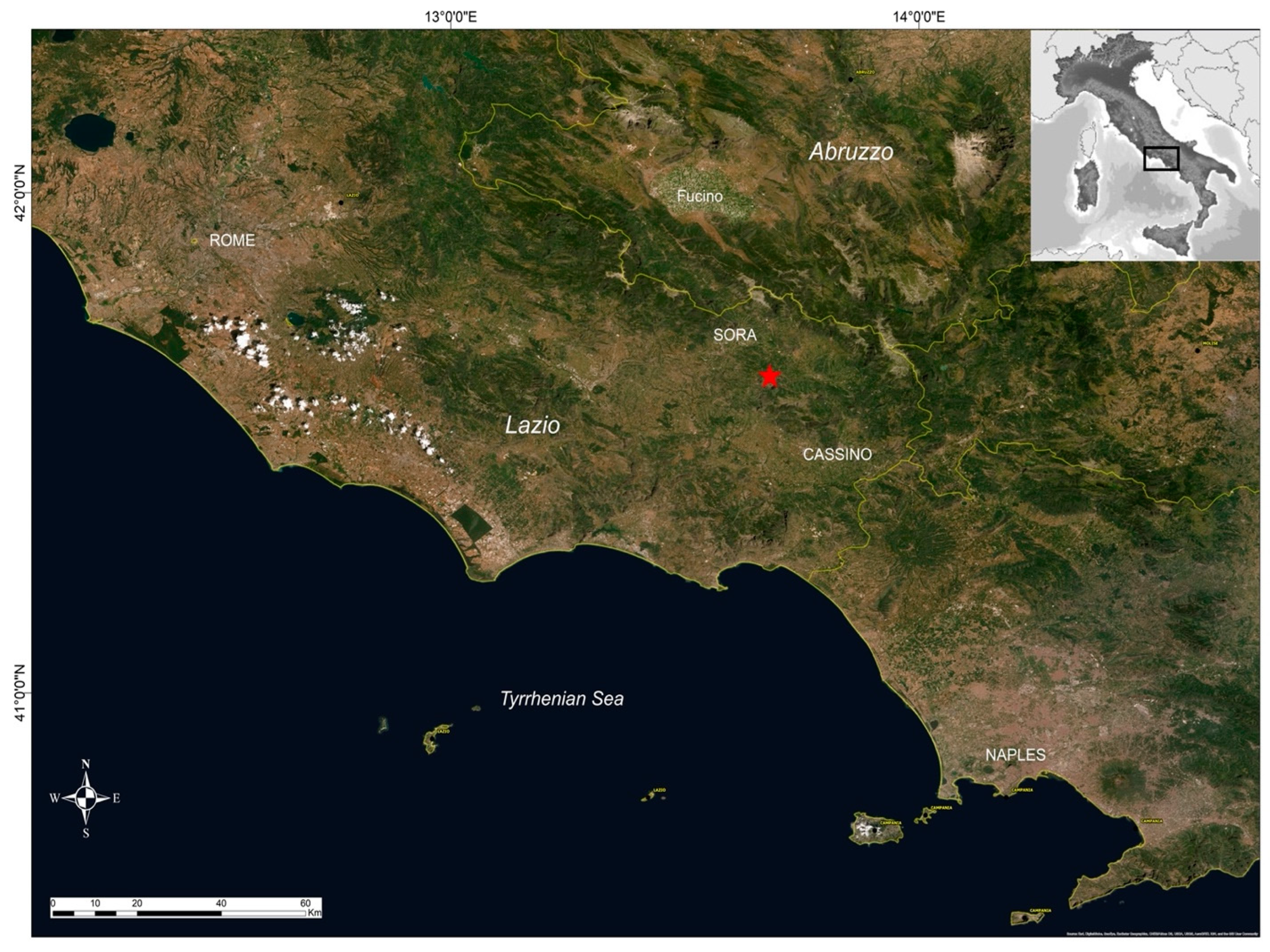
:1. Introduction
2. The 1654 Earthquake: Geological, Seismological, and Macroseismic Context
3. Effects of the Earthquake on the Natural Environment
4. Source Modeling
5. Results and Discussion
6. Conclusions
Author Contributions
Funding
Institutional Review Board Statement
Data Availability Statement
Acknowledgments
Conflicts of Interest
References
- Malinverno, A.; Ryan, W.B. Extension in the Tyrrhenian Sea and shortening in the Apennines as result of arc migration driven by sinking of the litosphere. Tectonics 1986, 5, 227–245. [Google Scholar] [CrossRef]
- Calamita, F.; Satolli, S.; Scisciani, V.; Esestime, P.; Pace, P. Contrasting styles of fault reactivation in curved orogenic belts: Examples from the Central Apennines (Italy). Geol. Soc. Am. Bull. 2011, 123, 1097–1111. [Google Scholar] [CrossRef]
- Vai, G.B. Structure and stratigraphy: An overview. In Anatomy of an Orogen: The Apennines and Adjacent Mediterranean Basins; Vai, G.B., Martini, I.P., Eds.; Kluwer Academic Publ.: Dordrecht, The Netherlands, 2011; pp. 14–32. [Google Scholar] [CrossRef]
- Montone, P.; Mariucci, M.T. The new release of the Italian contemporary stress map. Geophys. J. Int. 2016, 205, 1525–1531. [Google Scholar] [CrossRef]
- Rovida, A.; Locati, M.; Camassi, R.; Lolli, B.; Gasperini, P.; Antonucci, A. Catalogo Parametrico dei Terremoti Italiani (CPTI15), versione 3.0; Istituto Nazionale di Geofisica e Vulcanologia (INGV): Milano, Italy, 2021. [CrossRef]
- Cinti, F.R.; Pantosti, D.; Lombardi, A.M.; Civico, R. Modeling of earthquake chronology from paleoseismic data: Insights for regional earthquake recurrence and earthquake storms in the Central Apennines. Tectonophysics 2021, 816, 229016. [Google Scholar] [CrossRef]
- Gasperini, P.; Vannucci, G.; Tripone, D.; Boschi, E. The location and sizing of historical earthquakes using the attenuation of macroseismic intensity with distance. Bull. Seism. Soc. Am. 2010, 100, 2035–2066. [Google Scholar] [CrossRef]
- Galli, P.A.C.; Naso, J.A. Unmasking the 1349 earthquake source (southern Italy): Paleoseismological and archaeoseismological indications from the Aquae Iuliae fault. J. Struct. Geol. 2009, 31, 128–149. [Google Scholar] [CrossRef]
- Tertulliani, A.; Rossi, A.; Castelli, V.; Meletti, C.; D’Amico, V. Spunti e contrappunti di sismologia storica: 1349 annus horribilis, Abstract, 30° Convegno Nazionale Gruppo Nazionale di Geofisica della Terra Solida. Sessione 2011, 1.1, 14–17. [Google Scholar]
- ISIDe Working Group. Italian Seismological Instrumental and Parametric Database (ISIDe); Istituto Nazionale di Geofisica e Vulcanologia (INGV): Milano, Italy, 2007. [Google Scholar] [CrossRef]
- Frepoli, A.; Cimini, G.B.; De Gori, P.; De Luca, G.; Marchetti, A.; Monna, S.; Montuori, C.; Pagliuca, N.M. Seismic sequences and swarms in the Latium-Abruzzo-Molise Apennines (central Italy): New observations and analysis from a dense monitoring of the recent activity. Tectonophysics 2017, 712, 312–329. [Google Scholar] [CrossRef]
- ITHACA Working Group. ITHACA (Italy Hazard from Capable Faulting), a Database of Active Capable Faults of the Italian Territory; Via Vitaliano Brancati: Roma, Italy, 2019. [Google Scholar]
- Boncio, P.; Lavecchia, G.; Pace, B. Defining a model of 3D seismogenic sources for Seismic Hazard Assessment applications: The case of central Apennines (Italy). J. Seismol. 2004, 8, 407–425. [Google Scholar] [CrossRef]
- Dixit Dominus, G.; Maceroni, D.; Falcucci, E.; Galadini, F.; Gori, S.; Moro, M.; Saroli, M. Evidenze di Tettonica Attiva Lungo la Faglia Della val Roveto, Media Valle del Fiume Liri (Appennino Centrale), 39° GNGTS 2021. 2021. Available online: http://gngts.inogs.it/sites/default/files/Programma_GNGTS_2021.pdf (accessed on 22 December 2021).
- Saroli, M.; Moro, M.; Cinti, F.R.; Montone, P. La faglia Val Roveto-Atina (Appennino Centrale): Evidenze di Attività Tettonica Quaternaria. Riassunti Estesi Delle Comunicazioni, 25° GNGTS 2006. 2006. Available online: https://www.google.com.hk/search?source=univ&tbm=isch&q=Evidenze+di+attivit%C3%A0+tettonica+Quaternaria.+Riassunti+estesi+delle+comunicazioni.+2006,+25%C2%B0+GNGTS,+2006.&fir=v1gEIP8Vvfb4mM%252CzLugEHnwfetpsM%252C_%253B53Hn7DwpbZJQJM%252Cfq6hDjtfwTEkzM%252C_%253B3JwXBawCu77dJM%252CQ3KOSPwqfndOZM%252C_%253BC3iYzBeFV2HSUM%252CQ3KOSPwqfndOZM%252C_&usg=AI4_-kSvspL0uqQzFeGaZVt8BweIGXt_bg&sa=X&ved=2ahUKEwjZqIjd6sT1AhXQZt4KHXCaBM4QjJkEegQIAhAC (accessed on 22 December 2021).
- Guidoboni, E.; Ferrari, G.; Tarabusi, G.; Sgattoni, G.; Comastri, A.; Mariotti, D.; Ciuccarelli, C.; Bianchi, M.G.; Valensise, G. CFTI5Med, the new release of the catalogue of strong earthquakes in Italy and in the Mediterranean area. Sci. Data 2019, 6, 80. [Google Scholar] [CrossRef] [PubMed]
- Marta, R. La Cattedrale di Sora; Inizio di un Restauro: Sora, Italy, 1982. [Google Scholar]
- Squilla, G. La cattedrale di Sora dal 1100 al 1961 / d., prefazione di d. Tommaso Leccisotti—Casamari: Tipografia dell’Abbazia. 1961; 150p, Ill.; 22 cm. [Google Scholar]
- Cicconio, E. Vera Relatione del Terremoto successo in Terra di Lavoro, con la desolazione di molte Terre, a 24 de Luglio 1654, Napoli. 1654; 8p. [Google Scholar]
- Vivenzio, G. Istoria de’ Tremuoti Avvenuti nella Provincia della Calabria Ulteriore, e Nella Città di Messina Nell’anno 1783 e di Quanto Nella Calabria fu Fatto per lo suo Risorgimento Fino al 1787 Preceduta da una Teoria, ed Istoria Generale de’ Tremuoti, 2 voll. 1788. Available online: https://www.maremagnum.com/libri-antichi/istoria-de-tremuoti-avvenuti-nella-provincia-della-calabria/163406203 (accessed on 22 December 2021).
- Biblioteca Apostolica Vaticana, Manoscritti, Barberiniani Latini, 4336, Relazione delli danni fatti dal terremoto seguito la notte delli 23 del cadente mese di giugno 1654. XVII sec.
- Febonio, M. Historiae Marsorum; Apud Michaelem Monachum: Neapoli, Italy, 1678; Volume 145. [Google Scholar]
- Archivio di Stato di Napoli, Regia Camera della Sommaria, Ruote, vol.52, cc.64-68, Consulta della Regia Camera della Sommaria Relativa alle Notizie Inviate dal Duca di Sora sui Danni Causati Nelle sue Terre dal Terremoto del 23 Luglio 1654, Napoli 28 Settembre 1654. Available online: http://www.cftilab.it/file_repository/pdf_T/003080-643001_T.pdf (accessed on 22 December 2021).
- Wakita, H. Water wells as possible indicators of tectonic strain. Science 1975, 189, 553–555. [Google Scholar] [CrossRef] [PubMed]
- Cucci, L. Insights into the geometry and faulting style of the causative faults of the M6.7 1805 and M6.7 1930 earthquakes in the Southern Apennines (Italy) from coseismic hydrological changes. Tectonophysics 2019, 751, 192–211. [Google Scholar] [CrossRef]
- Okada, Y. Surface deformation due to shear and tensile faults in an half-space. Bull. Seismol. Soc. Am. 1985, 75, 1135–1154. [Google Scholar] [CrossRef]
- Lin, J.; Stein, R.S. Stress triggering in thrust and subduction earthquakes, and stress interactions between the southern San Andreas and nearby thrust and strike-slip faults. J. Geophys. Res. 2004, 109, B02303. [Google Scholar] [CrossRef] [Green Version]
- Toda, S.; Stein, R.S.; Richards-Dinger, K.; Bozkurt, S. Forecasting the evolution of seismicity in Southern California: Animation in building stress transfer. J. Geophys. Res. 2005, 110, B05S16. [Google Scholar] [CrossRef]
- Carafa, M.M.C.; Galvani, A.; Di Naccio, D.; Kastelic, V.; Di Lorenzo, C.; Miccolis, S.; Sepe, V.; Pietrantonio, G.; Gizzi, C.; Massucci, A.; et al. Partitioning the ongoing extension of the central Apennines (Italy): Fault slip rates and bulk deformation rates from geodetic and stress data. J. Geophys. Res. Solid Earth 2020, 125, e2019JB018956. [Google Scholar] [CrossRef]


| Source | Length (km) | Width (km) | Min Depth (km) | Max Depth (km) | Strike° | Dip° | Rake° | Seismic Moment (Dyne cm) | Ref. |
|---|---|---|---|---|---|---|---|---|---|
| BF Balsorano | 16.0 | 12.0 | 1 | 11.4 | 134 | 60 | −50/−90/−130 | 2.9 × 1025 | [12] |
| PF Posta-Fibreno | 13.0 | 10.4 | 1 | 10.0 | 133 | 60 | −50/−90/−130 | 2.2 × 1025 | [12] |
| SFa Sora | 16.6 | 11.5 | 1 | 11.4 | 125 | 60 | −50/−90/−130 | 2.9 × 1025 | [12] |
| SFb Sora | 17.0 | 14.4 | 1 | 13.5 | 115 | 60 | −50/−90/−130 | 3.7 × 1025 | [13] |
| MF Macroseismic | 19.6 | 10.3 | 5 | 13.9 | 142 | 60 | −50/−90/−130 | 3.2 × 1025 | [7] |
| No | Locality | Lat° | Lon° | Epic. dist. (km) | Effects | References |
|---|---|---|---|---|---|---|
| 1 | Cassino | 41.480 | 13.832 | 21.2 | Increase in discharge of Gari springs | [19,20] |
| 2 | Isola del Liri | 41.680 | 13.574 | 10.5 | Decrease in flow from Liri River | [21] |
| 3 | Isola del Liri | 41.678 | 13.571 | 10.6 | Turbid water from Liri River | [21] |
| 4 | M. Corvo | 41.772 | 13.468 | 23.5 | Wide surface fracturing | [16,19,20] |
| 5 | Luco dei Marsi | 41.973 | 14.461 | 41.8 | Chasms and lowering of waters in the Fucino Lake area | [22] |
| 6 | Sora | 41.723 | 13.615 | 11.3 | Inferred coseismic fracturing in the flooring of the Cathedral | [17,18] |
| 7 | Roccasecca | 41.554 | 13.669 | 9.1 | Landslide | [16,23] |
Publisher’s Note: MDPI stays neutral with regard to jurisdictional claims in published maps and institutional affiliations. |
© 2022 by the authors. Licensee MDPI, Basel, Switzerland. This article is an open access article distributed under the terms and conditions of the Creative Commons Attribution (CC BY) license (https://creativecommons.org/licenses/by/4.0/).
Share and Cite
Cucci, L.; Cinti, F.R. In Search of the 1654 Seismic Source (Central Italy): An Obscure, Strong, Damaging Earthquake Occurred Less than 100 km from Rome and Naples. Appl. Sci. 2022, 12, 1150. https://doi.org/10.3390/app12031150
Cucci L, Cinti FR. In Search of the 1654 Seismic Source (Central Italy): An Obscure, Strong, Damaging Earthquake Occurred Less than 100 km from Rome and Naples. Applied Sciences. 2022; 12(3):1150. https://doi.org/10.3390/app12031150
Chicago/Turabian StyleCucci, Luigi, and Francesca R. Cinti. 2022. "In Search of the 1654 Seismic Source (Central Italy): An Obscure, Strong, Damaging Earthquake Occurred Less than 100 km from Rome and Naples" Applied Sciences 12, no. 3: 1150. https://doi.org/10.3390/app12031150
APA StyleCucci, L., & Cinti, F. R. (2022). In Search of the 1654 Seismic Source (Central Italy): An Obscure, Strong, Damaging Earthquake Occurred Less than 100 km from Rome and Naples. Applied Sciences, 12(3), 1150. https://doi.org/10.3390/app12031150