Landslide Susceptibility Assessment Considering Landslide Volume: A Case Study of Yangou Watershed on the Loess Plateau (China)
Abstract
:1. Introduction
2. Study Area
3. Methods
4. Results and Discussion
4.1. Landslide Inventory
4.2. Application of the VR Model
4.3. Application of the RIRA Method
4.4. Results of the Landslide Susceptibility Mapping
5. Conclusions
Author Contributions
Funding
Institutional Review Board Statement
Informed Consent Statement
Data Availability Statement
Acknowledgments
Conflicts of Interest
References
- Xu, X.; Liu, Z.; Xiao, P.; Guo, W.; Zhang, H.; Zhao, C.; Yan, Q. Landslide on the steep loess slope: Behavior, trigger and sensitivity. Catena 2015, 135, 231–239. [Google Scholar] [CrossRef]
- Hadmoko, D.S.; Lavigne, F.; Samodra, G. Application of a semiquantitative and GIS-based statistical model to landslide susceptibility zonation in Kayangan Catchment, Java, Indonesia. Nat. Hazards 2017, 87, 437–468. [Google Scholar] [CrossRef]
- Varnes, D.J. Landslide types and processes. Landslides Eng. Pract. 1958, 24, 20–47. [Google Scholar]
- Tsangaratos, P.; Ilia, I.; Hong, H.; Chen, W.; Xu, C. Applying Information Theory and GIS-based quantitative methods to produce landslide susceptibility maps in Nancheng County, China. Landslides 2017, 14, 1091–1111. [Google Scholar] [CrossRef]
- Althuwaynee, O.F.; Pradhan, B. Semi-quantitative landslide risk assessment using GIS-based exposure analysis in Kuala Lumpur City. Geomat. Nat. Hazards Risk 2017, 8, 706–732. [Google Scholar] [CrossRef] [Green Version]
- Regmi, A.D.; Poudel, K. Assessment of landslide susceptibility using GIS-based evidential belief function in Patu Khola watershed, Dang, Nepal. Environ. Earth Sci. 2016, 75, 743. [Google Scholar] [CrossRef]
- Beek, R.V.; Cammeraat, E.; Andreu, V.; Mickovski, S.B.; Dorren, L. Hillslope processes: Mass wasting, slope stability and erosion. In Slope Stability and Erosion Control: Ecotechnological Solutions; Norris, J.E., Stokes, A., Mickovski, S.B., Cammeraat, E., van Beek, R., Nicoll, B.C., Achim, A., Eds.; Springer: Berlin/Heidelberg, Germany, 2008; pp. 17–64. [Google Scholar]
- Xu, J. Sediment-heavily containing flows in slope-channel systems of gullied hilly area in the Loess Plateau (I): Influences of landforms and gravitational erosion. J. Nat. Disasters 2004, 13, 55–60. (In Chinese) [Google Scholar]
- Highland, L.; Bobrowsky, P.T. The Landslide Handbook: A Guide to Understanding Landslides; US Geological Survey: Reston, VA, USA, 2008.
- Guzzetti, F.; Reichenbach, P.; Ardizzone, F.; Cardinali, M.; Galli, M. Estimating the quality of landslide susceptibility models. Geomorphology 2006, 81, 166–184. [Google Scholar] [CrossRef]
- Oh, H.-J.; Lee, S. Landslide susceptibility mapping on Panaon Island, Philippines using a geographic information system. Environ. Earth Sci. 2011, 62, 935–951. [Google Scholar] [CrossRef]
- Conforti, M.; Pascale, S.; Sdao, F. Mass movements inventory map of the Rubbio stream catchment (Basilicata—South Italy). J. Maps 2015, 11, 454–463. [Google Scholar] [CrossRef]
- Pourghasemi, H.R.; Pradhan, B.; Gokceoglu, C. Application of fuzzy logic and analytical hierarchy process (AHP) to landslide susceptibility mapping at Haraz watershed, Iran. Nat. Hazards 2012, 63, 965–996. [Google Scholar] [CrossRef]
- Zhao, H.; Yao, L.; Mei, G.; Liu, T.; Ning, Y. A Fuzzy Comprehensive Evaluation Method Based on AHP and Entropy for a Landslide Susceptibility Map. Entropy 2017, 19, 396. [Google Scholar] [CrossRef]
- Yoshimatsu, H.; Abe, S. A review of landslide hazards in Japan and assessment of their susceptibility using an analytical hierarchic process (AHP) method. Landslides 2006, 3, 149–158. [Google Scholar] [CrossRef]
- Lee, S.; Sambath, T. Landslide susceptibility mapping in the Damrei Romel area, Cambodia using frequency ratio and logistic regression models. Environ. Earth Sci. 2006, 50, 847–855. [Google Scholar] [CrossRef]
- Saito, H.; Nakayama, D.; Matsuyama, H. Comparison of landslide susceptibility based on a decision-tree model and actual landslide occurrence: The Akaishi Mountains, Japan. Geomorphology 2009, 109, 108–121. [Google Scholar] [CrossRef]
- Youssef, A.M.; Pourghasemi, H.R.; Pourtaghi, Z.S.; Al-Katheeri, M.M. Landslide susceptibility mapping using random forest, boosted regression tree, classification and regression tree, and general linear models and comparison of their performance at Wadi Tayyah Basin, Asir Region, Saudi Arabia. Landslides 2016, 13, 839–856. [Google Scholar] [CrossRef]
- Chen, W.; Pourghasemi, H.R.; Zhao, Z. A GIS-based comparative study of Dempster-Shafer, logistic regression and artificial neural network models for landslide susceptibility mapping. Geocarto Int. 2017, 32, 367–385. [Google Scholar] [CrossRef]
- Kavzoglu, T.; Sahin, E.K.; Colkesen, I. Landslide susceptibility mapping using GIS-based multi-criteria decision analysis, support vector machines, and logistic regression. Landslides 2014, 11, 425–439. [Google Scholar] [CrossRef]
- Zhu, T.; Xu, X.; Zhu, A. Spatial variation in the frequency and magnitude of mass movement in a semiarid, complex-terrain agricultural watershed on the Loess Plateau of China. Land Degrad. Dev. 2019, 30, 1095–1106. [Google Scholar] [CrossRef]
- Lucas-Borja, M.E.; Zema, D.A.; Guzman, M.D.H.; Yang, Y.; Hernández, A.C.; Xiangzhou, X.; Carrà, M.G.; Nichols, M.; Cerdà, A. Exploring the influence of vegetation cover, sediment storage capacity and channel dimensions on stone check dam conditions and effectiveness in a large regulated river in México. Ecol. Eng. 2018, 122, 39–47. [Google Scholar] [CrossRef] [Green Version]
- Geospatial Data Cloud Site, Computer Network Information Center, Chinese Academy of Sciences. Available online: http://www.gscloud.cn (accessed on 23 March 2022).
- Resource and Environment Science and Data Center. Available online: https://www.resdc.cn/data.aspx?DATAID=335 (accessed on 23 March 2022).
- Resource and Environment Data Cloud Platform. Available online: http://www.resdc.cn/Default.aspx (accessed on 23 March 2022).
- Sassa, K.; Canuti, P.; Yin, Y. Landslide Science for a Safer Geoenvironment: Volume 2: Methods of Landslide Studies; Springer: Berlin/Heidelberg, Germany, 2014. [Google Scholar]
- Chen, A.; Zhang, D.; Fan, J.; Liu, G. Mechanical mechanism and simulation experiment of the collapse of gully cliff in Yuanmou Dry-Hot Valley. Sci. Soil Water Conserv. 2012, 10, 29–35. (In Chinese) [Google Scholar]
- Zhang, M. Geological Disaster of Landslide and Collapse in Baota District, Yan’an; Geological Publishing House: Beijing, China, 2008. [Google Scholar]
- Xu, X.-Z.; Guo, W.-Z.; Liu, Y.-K.; Ma, J.-Z.; Wang, W.-L.; Zhang, H.-W.; Gao, H. Landslides on the Loess Plateau of China: A latest statistics together with a close look. Nat. Hazards 2017, 86, 1393–1403. [Google Scholar] [CrossRef]
- Ashournejad, Q.; Hosseini, A.; Pradhan, B.; Hosseini, S.J. Hazard zoning for spatial planning using GIS-based landslide susceptibility assessment: A new hybrid integrated data-driven and knowledge-based model. Arab. J. Geosci. 2019, 12, 126. [Google Scholar] [CrossRef]
- Skilodimou, H.D.; Bathrellos, G.D.; Chousianitis, K.; Youssef, A.M.; Pradhan, B. Multi-hazard assessment modeling via multi-criteria analysis and GIS: A case study. Environ. Earth Sci. 2019, 78, 47. [Google Scholar] [CrossRef]
- Assouline, S.; Ben-Hur, M. Effects of rainfall intensity and slope gradient on the dynamics of interrill erosion during soil surface sealing. Catena 2006, 66, 211–220. [Google Scholar] [CrossRef]
- De Rose, R.C. Slope control on the frequency distribution of shallow landslides and associated soil properties, North Island, New Zealand. Earth Surf. Processes Landf. 2013, 38, 356–371. [Google Scholar] [CrossRef]
- Kavzoglu, T.; Sahin, E.K.; Colkesen, I. An assessment of multivariate and bivariate approaches in landslide susceptibility mapping: A case study of Duzkoy district. Nat. Hazards 2015, 76, 471–496. [Google Scholar] [CrossRef]
- Dai, F.C.; Lee, C.F. Landslide characteristics and slope instability modeling using GIS, Lantau Island, Hong Kong. Geomorphology 2002, 42, 213–228. [Google Scholar] [CrossRef]
- Dragićević, S.; Lai, T.; Balram, S. GIS-based multicriteria evaluation with multiscale analysis to characterize urban landslide susceptibility in data-scarce environments. Habitat Int. 2015, 45, 114–125. [Google Scholar] [CrossRef]
- Chen, W.; Pourghasemi, H.R.; Naghibi, S.A. Prioritization of landslide conditioning factors and its spatial modeling in Shangnan County, China using GIS-based data mining algorithms. Bull. Eng. Geol. Environ. 2018, 77, 611–629. [Google Scholar] [CrossRef]
- Liu, Y.; Fu, B.; Lü, Y.; Wang, Z.; Gao, G. Hydrological responses and soil erosion potential of abandoned cropland in the Loess Plateau, China. Geomorphology 2012, 138, 404–414. [Google Scholar] [CrossRef]
- Tang, Q.; Bennett, S.J.; Xu, Y.; Li, Y. Agricultural practices and sustainable livelihoods: Rural transformation within the Loess Plateau, China. Appl. Geogr. 2013, 41, 15–23. [Google Scholar] [CrossRef]
- Mansouri Daneshvar, M.R. Landslide susceptibility zonation using analytical hierarchy process and GIS for the Bojnurd region, northeast of Iran. Landslides 2014, 11, 1079–1091. [Google Scholar] [CrossRef]
- Xu, Y.; Tang, Q. Land use optimization at small watershed scale on the Loess Plateau. J. Geogr. Sci. 2009, 19, 577–586. [Google Scholar] [CrossRef] [Green Version]
- Thomas, J.; Joseph, S.; Thrivikramji, K.; Arunkumar, K. Sensitivity of digital elevation models: The scenario from two tropical mountain river basins of the Western Ghats, India. Geosci. Front. 2014, 5, 893–909. [Google Scholar] [CrossRef] [Green Version]
- Lu, K.; Zhu, D. Theoretical and experimental study of effect of slope topography on its stability. Chin. J. Rock Mech. Eng. 2014, 33, 35–42. (In Chinese) [Google Scholar]
- Xu, X.; Ma, Y.; Yang, W.; Zhang, H.; Tarolli, P.; Jiang, Y.; Yan, Q. Qualifying the influence of scar geometry on mass failure in loess gully sidewalls using laboratory experimentation. Catena 2020, 187, 104252. [Google Scholar] [CrossRef]
- Derbyshire, E.; Dijkstra, T.; Smalley, I.; Li, Y. Failure mechanisms in loess and the effects of moisture content changes on remoulded strength. Quat. Int. 1994, 24, 5–15. [Google Scholar] [CrossRef]
- Zhang, F.; Pei, X.; Chen, W.; Liu, G.; Liang, S. Spatial variation in geotechnical properties and topographic attributes on the different types of shallow landslides in a loess catchment, China. Eur. J. Environ. Civ. Eng. 2014, 18, 470–488. [Google Scholar] [CrossRef]
- Liu, C.-C. Preparing a landslide and shadow inventory map from high-spatial-resolution imagery facilitated by an expert system. J. Appl. Remote Sens. 2015, 9, 96080. [Google Scholar] [CrossRef]
- Wang, J.-J.; Liang, Y.; Zhang, H.-P.; Wu, Y.; Lin, X. A loess landslide induced by excavation and rainfall. Landslides 2014, 11, 141–152. [Google Scholar] [CrossRef]
- Shang, J. Study on the Stability of Loess Landslide in the Baota District of Yan’an City—A Case Study: Wohushan Landslide Chang’an University; Chang’an University: Xi’an, China, 2011. [Google Scholar]
- Wang, L.; Wei, S.; Horton, R.; Shao, M. Effects of vegetation and slope aspect on water budget in the hill and gully region of the Loess Plateau of China. Catena 2011, 87, 90–100. [Google Scholar] [CrossRef]
- Zhang, M.; Liu, J. Controlling factors of loess landslides in western China. Environ. Earth Sci. 2010, 59, 1671–1680. [Google Scholar] [CrossRef]
- Stokes, A.; Sotir, R.; Chen, W.; Ghestem, M. Soil bio- and eco-engineering in China: Past experience and future priorities. Ecol. Eng. 2010, 36, 247–257. [Google Scholar] [CrossRef]
- Tian, J.; Liu, P.; Shimizu, H.; Inanaga, S. A case study on combating desertification at a small watershed in the hills-gully area of loess plateau, China. In Plant Responses to Air Pollution and Global Change; Springer: Tokyo, Japan, 2005; pp. 277–284. [Google Scholar]


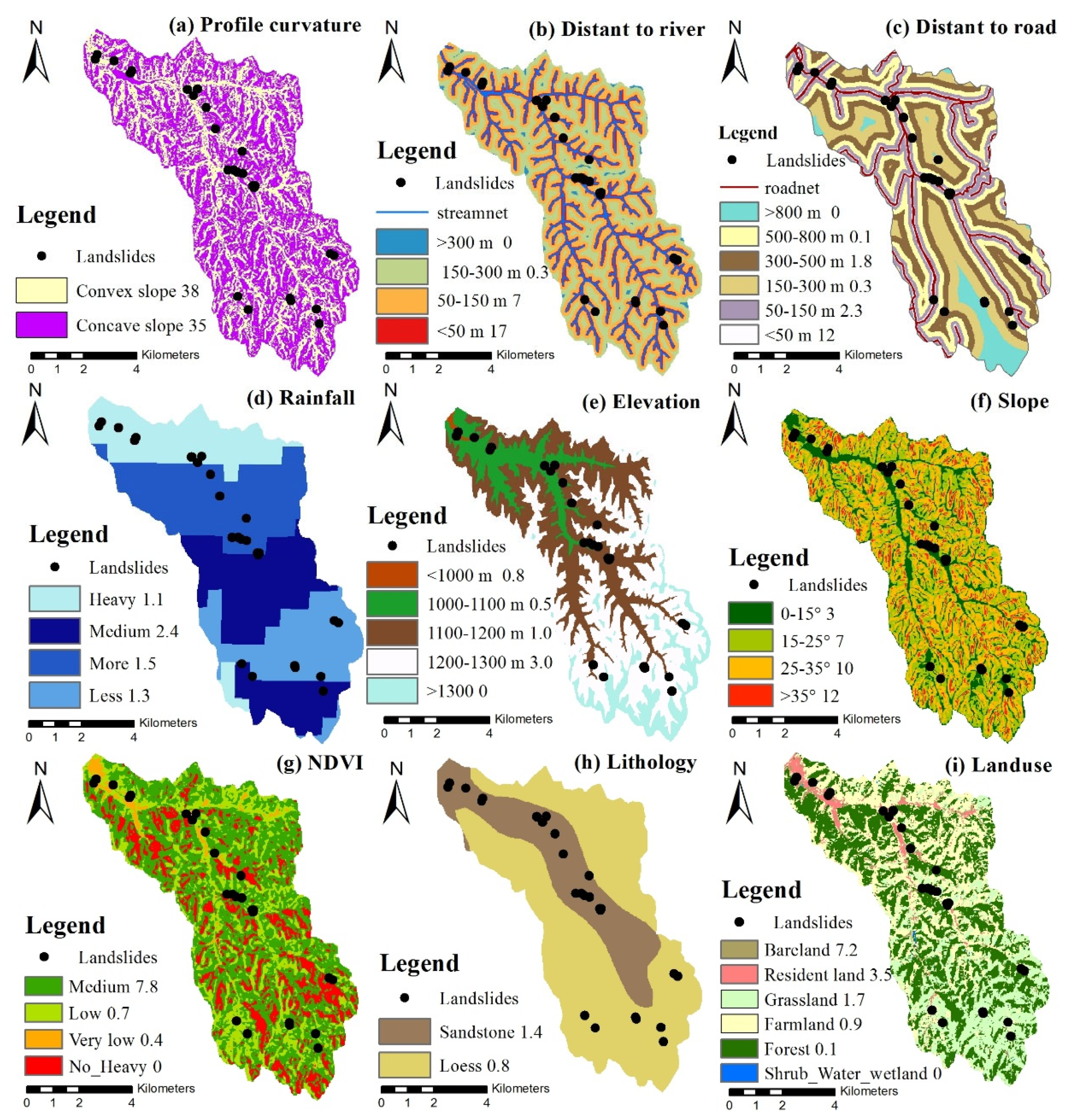
| Independent Variable | Classes | Vjk*/Vjk | T*/T | VRjk |
|---|---|---|---|---|
| Slope angle (°) | 0–15 | 0.7294 | 0.8629 | 0.8453 |
| 15–25 | 0.2427 | 0.1272 | 1.9089 | |
| 25–35 | 0.0259 | 0.0094 | 2.7538 | |
| >35 | 0.0019 | 0.0006 | 3.5264 | |
| Elevation (m) | <1000 | 0.1448 | 0.9991 | 0.1450 |
| 1000–1100 | 0.0947 | 0.9874 | 0.0959 | |
| 1100–1200 | 0.1886 | 0.9946 | 0.1896 | |
| 1200–1300 | 0.5719 | 0.9937 | 0.5755 | |
| >1300 | 0.0000 | 0.0000 | 0.0000 | |
| NDVI | no cover | 0.0000 | 0.0004 | 0.0000 |
| very low cover | 0.1478 | 0.0263 | 0.1778 | |
| low cover | 0.7124 | 0.2459 | 0.3451 | |
| medium cover | 0.1398 | 0.5355 | 3.8301 | |
| high cover | 0.0000 | 0.1919 | 0.0000 | |
| Land-use | Farmland | 0.2981 | 0.3063 | 0.9734 |
| Forest | 0.0199 | 0.4000 | 0.0498 | |
| Grassland | 0.4029 | 0.2345 | 1.7180 | |
| Shrubland | 0.0000 | 0.0021 | 0.0000 | |
| Wetland | 0.0000 | 0.0000 | 0.0000 | |
| Water | 0.0000 | 0.0006 | 0.0000 | |
| Resident land | 0.1313 | 0.0367 | 3.5780 | |
| Bareland | 0.1478 | 0.0198 | 7.4512 | |
| Lithology | Sandstone | 0.4169 | 0.2848 | 1.4640 |
| Loess | 0.5831 | 0.7152 | 0.8152 | |
| Distant to road (m) | <50 | 0.5289 | 0.4101 | 1.2897 |
| 50–150 | 0.2454 | 0.9813 | 0.2501 | |
| 150–300 | 0.0100 | 0.8237 | 0.0122 | |
| 300–500 | 0.1824 | 0.9151 | 0.1994 | |
| 500–800 | 0.0333 | 1.1883 | 0.0280 | |
| >800 | 0.0000 | 0.0000 | 0.0000 | |
| Distant to river (m) | <50 | 0.7368 | 1.1093 | 0.6642 |
| 50–150 | 0.2543 | 0.9612 | 0.2645 | |
| 150–300 | 0.0089 | 0.8106 | 0.0110 | |
| >300 | 0.0000 | 0.0000 | 0.0000 | |
| Profile curvature | Concave slope | 0.5151 | 0.5384 | 0.9567 |
| Convex slope | 0.4849 | 0.4616 | 1.0505 | |
| Rainfall | Less rainfall area | 0.2051 | 0.9998 | 0.2052 |
| Medium rainfall area | 0.3779 | 1.0002 | 0.3779 | |
| More rainfall area | 0.2415 | 0.9996 | 0.2416 | |
| Heavy rainfall area | 0.1755 | 0.9996 | 0.1755 |
| Parameter | Independent Variables | ||||||||
|---|---|---|---|---|---|---|---|---|---|
| Profile Curvature | Distant to River | Distant to Road | Rainfall | Elevation | Slope | NDVI | Lithology | Land-Use | |
| Absolute Sensitivity | 0.3616 | 0.2567 | 0.0908 | 0.0628 | 0.0523 | 0.0345 | 0.0203 | 0.0099 | 0.0097 |
Publisher’s Note: MDPI stays neutral with regard to jurisdictional claims in published maps and institutional affiliations. |
© 2022 by the authors. Licensee MDPI, Basel, Switzerland. This article is an open access article distributed under the terms and conditions of the Creative Commons Attribution (CC BY) license (https://creativecommons.org/licenses/by/4.0/).
Share and Cite
Gao, H.; Zhang, X. Landslide Susceptibility Assessment Considering Landslide Volume: A Case Study of Yangou Watershed on the Loess Plateau (China). Appl. Sci. 2022, 12, 4381. https://doi.org/10.3390/app12094381
Gao H, Zhang X. Landslide Susceptibility Assessment Considering Landslide Volume: A Case Study of Yangou Watershed on the Loess Plateau (China). Applied Sciences. 2022; 12(9):4381. https://doi.org/10.3390/app12094381
Chicago/Turabian StyleGao, Hang, and Xia Zhang. 2022. "Landslide Susceptibility Assessment Considering Landslide Volume: A Case Study of Yangou Watershed on the Loess Plateau (China)" Applied Sciences 12, no. 9: 4381. https://doi.org/10.3390/app12094381
APA StyleGao, H., & Zhang, X. (2022). Landslide Susceptibility Assessment Considering Landslide Volume: A Case Study of Yangou Watershed on the Loess Plateau (China). Applied Sciences, 12(9), 4381. https://doi.org/10.3390/app12094381


