Article

Developing a Guideline of Unmanned Aerial Vehicle’s Acquisition Geometry for Landslide Mapping and Monitoring

by
Konstantinos G. Nikolakopoulos
*,
Aggeliki Kyriou
and
Ioannis K. Koukouvelas
Department of Geology, University of Patras, 265 04 Patras, Greece
*
Author to whom correspondence should be addressed.
Appl. Sci. 2022, 12(9), 4598; https://doi.org/10.3390/app12094598
Submission received: 21 March 2022 / Revised: 27 April 2022 / Accepted: 29 April 2022 / Published: 2 May 2022
(This article belongs to the Special Issue Mapping, Monitoring and Assessing Disasters)

Abstract

:
Remote sensing data and techniques are widely used for monitoring and managing natural or man-made disasters, due to their timeliness and their satisfactory accuracy. A key stage in disaster research is the detailed and precise mapping of an affected area. The current work examines the relationship that may exist between the acquisition geometry of Unmanned Aerial Vehicle (UAV) campaigns and the topographic characteristics of an investigated area, toward landslide mapping and monitoring that is as accurate as possible. In fact, this work, concerning the systematic research of the acquisition geometry of UAV flights over multiple active landslides, is conducted for the first time and is focused on creating a guideline for any researcher trying to follow the UAV photogrammetric survey during landslide mapping and monitoring. In particular, UAV flights were executed over landslide areas with different characteristics (land cover, slope, etc.) and the collected data from each area were classified into three groups depending on UAV acquisition geometry, i.e., nadir imagery, oblique imagery, and an integration of nadir and oblique imagery. High-resolution orthophotos and Digital Surface Models (DSMs) emerged from the processing of the UAV imagery of each group through structure-from-motion photogrammetry (SfM). Accuracy assessment was carried out using quantitative and qualitative comparative approaches, such as root mean square error calculation, length comparison, and mean center estimation. The evaluation of the results revealed that there is a strong relationship between UAV acquisition geometry and landslide characteristics, which is evident in the accuracy of the generated photogrammetric products (orthophotos, DSMs). In addition, it was proved that the synergistic processing of nadir and oblique imagery increased overall centimeter accuracy.

1. Introduction

Remote sensing has emerged as an important and valuable tool for various earth observation applications. In particular, remote sensing data and techniques are widely used for monitoring and managing natural or man-made disasters, due to their timeliness and their satisfactory accuracy [1]. The development of UAVs has opened up new possibilities in hazard assessment and disaster risk management [2,3,4]. In fact, these low-cost remote sensors have proven their effectiveness in mapping hazards and disasters (earthquakes, floods, landslides, etc.), monitoring human activity during emergencies, and protecting and preserving cultural heritage sites affected by geo-hazards [5,6,7,8,9,10].
A key stage in disaster research is the detailed and precise mapping of an affected area. In this framework, scientists have developed several new processing methodologies, in which different parameters were assessed in achieving the most efficient results. Specifically, the selection of an appropriate number of ground control points (GCPs) during the georeferencing procedure of the obtained UAV imagery was one of the primary parameters under investigation. Thus, various photogrammetric campaigns, consisting of different combinations of GCPs (varying from 4 to up to 20), were evaluated using root mean square error (RMSE) values extracted from the respective DSMs [11,12,13]. The results demonstrated a clear influence of the number of GCPs on the accuracy of UAV photogrammetry. Although the selection of about 20 GCPs (defined according to the study area) managed to reduce the RSME by 50%, it was proved that a higher number of GCPs slightly improved the accuracy. Moreover, other studies dealt with analyzing the distribution of GCPs within the study area and the effect of such distribution on the accuracy of the derived DSMs, which decreases as the distance to the nearest GCP increases [14,15]. In general, the accuracy of photogrammetric products increases asymptotically as the number of GCPs increase, until an optimal GCP density is reached.
The collection of GCPs is a time-consuming task. Thus, the development of UAVs with onboard Global Navigation Satellite System Real Time Kinematic (GNSS RTK) positioning—in which the georeferencing of the images does not require GCPs—constitutes a promising solution [16,17]. The main disadvantage of the specific approach is the presence of systematic elevation errors, which emerge from the incorrect determination of the interior orientation parameters estimated during bundle adjustment [18]. A recent study proposed that a combination of two UAV flights at the same altitude, consisting of nadir and oblique imagery, was able to reduce the systematic elevation error to less than 0.03 m [19].
Other approaches focused on evaluating the effect of different scenarios, consisting of multi-view camera combinations, on the accuracy of UAV photogrammetry. Specifically, the combination of non-metric oblique and vertical views, along with an appropriate collection of GCPs, has significantly enhanced the accuracy of the photogrammetric procedure, extracting DSMs comparable to those derived by Light Detection and Ranging (LiDAR) [20]. Indeed, this integration of nadir and oblique imagery has proven its effectiveness in numerous studies, including the reconstruction of the surfaces and the determination of the main geometries in a quarry environment, the geomorphological mapping of landslides, and geotechnical/ hazard mapping [21,22,23]. In addition, it has been proven that the reconstruction of a topographically complex terrain requires the synergy of oblique and facade images to complement nadir views [24]. This synergistic use significantly improved the geometric accuracy of topographic reconstruction, by approximately 35%.
Although the combination of multi-view UAV imagery is a very successful approach in a variety of applications, nadir images combined with a dense distribution of GCPs constituted an ideal solution for the reconstruction of 3D agricultural surfaces [25]. On the other hand, oblique UAV imagery was considered particularly suitable for the three-dimensional modeling of buildings, cities, or urban settlements, presenting an enhanced achievable accuracy [26]. Moreover, oblique-viewing images can be utilized effectively for the 3D modelling of historical architectures and cultural heritage research, especially in areas characterized by limited accessibility [27]. In addition, oblique images increased by 50% the accuracy of 3D representations of topography in areas with high and steep slopes [28].
The current study aims to create a guideline for researchers who try to follow the UAV photogrammetric survey method for landslide mapping and monitoring, by exploring derived data quality (orthophotos and DSMs) in reference to data acquisition geometry. There are previous studies on the influence of the ground control number to the horizontal or vertical accuracy of orthophotos and DSMs, respectively [12,13,14,15]. However, the current study is the first to conduct systematic research on UAV data acquisition methodology applied on multiple active landslides. UAV flights were performed over four landslide areas with different characteristics (land cover, slope, volume, dimensions, etc.), and the collected data from each area were classified into three groups, depending on UAV acquisition geometry: (a) nadir-only images, (b) oblique-only images, and (c) an integration of nadir and oblique images. Moreover, a flat urban area was also surveyed for validation purposes. The processing of UAV imagery in each category was based on structure-from-motion (SfM) photogrammetry, leading to the creation of high resolution orthophotos and digital surface models (DSMs). Accuracy assessment was carried out using quantitative and qualitative comparative approaches, such as root mean square error calculation, length comparison, and mean center estimation. The derived results demonstrate the benefits of combining oblique and nadir images in order to reduce systematic errors and increase the overall accuracy of orthophotos and Digital Surface Models.

2. Materials and Methods

2.1. Case Studies

The selection of research areas was based on the criterion of heterogeneity in terms of slope, land cover, vegetation coverage, etc. Thus, four different landslides were set as case studies. We also surveyed a flat industrial area for validation purposes (Figure 1) (Table 1). In order to eliminate the influence of vegetation height on DSM production, the study areas presented, in general, with low and sparse vegetation, as described in Table 1.
The first landslide area is located close to the village of Moira, within Western Greece. The landslide occurred on 20 January 2017 on a mountainous, steep slope, covering an area of approximately 65,569.20 m2. The landslide material was spread 300 m in length and 300 m in width and it was geologically structured from flysch, limestone, and loose cherts. It was characterized as a complex slide, based on the different lithologies—silicate and/or silicate lithology was presented in the northwestern part, while limestones were detected in the southeast. The occurrence of the landslide was related to geological factors (flysch lithology), as well as to the rapid snow melting. It has been demonstrated that the increase of the water content of clay soils (flysch) reduces the shear strength of soils, acting as a triggering factor for the occurrence of landslides [29].
The destruction of the road connecting the village of Moira with the city of Patras, as well as a significant change in the local landscape, were the main consequences of the landslide.
The second landslide took place in November 2015 on the Egkremni beach on the island of Lefkada; it was classified as a debris slide . The Ionian Islands constitute the northwestern part of the Hellenic arc, which is considered as a site of complex continent-continent to continent-ocean convergent plate margins. The Cephalonia Transform Fault Zone (CTFZ) is recognized as the major tectonic structure of the site and is responsible for the particularly active seismicity in the wider area. In addition, another fault, named Athani, is detected ashore, shaping the west coast of Lefkada island [30,31]. The Athani fault, along with smaller, parallel faults with similar kinematics, form steep slopes, which are an ideal site for the occurrence of landslides during seismic events [32]. On 17 November 2015, a 6.5 magnitude earthquake struck the west coast of the island, causing a series of landslides on the cliffs [33,34].
Another active continental region, in terms of tectonics and seismicity, is Northern Peloponnese, due to the fast-extending rift of the Gulf of Corinth. This third area of interest is located close to the village of Kato Zachlorou within Western Greece. The first mass movements at the specific area occurred in April 2019, while the main event, consisting of rock falls and earth flows, took place on 4 April 2020. The repetitive sliding episodes were strongly associated with the increase of the water content of the clay soils, due to intense rainfall [29].
The fourth area of interest includes a landslide located in a semi-mountainous village of Western Greece named Messarista. Extremely heavy and prolonged rains hit the wider region on 11 December 2021, acting as a main triggering factor for the occurrence of a series of landslides in different places throughout the region, as well as within the village of Messarista. The phenomenon is still ongoing and is being monitored by local authorities, while the landslides were classified as earth slides and earth flows.
Finally, a flat industrial area, covering part of the new port of the city of Patras, was chosen for the validation of the results, due to the past view on photogrammetry, in which flat areas were surveyed using nadir imagery solely.

2.2. Data Collection
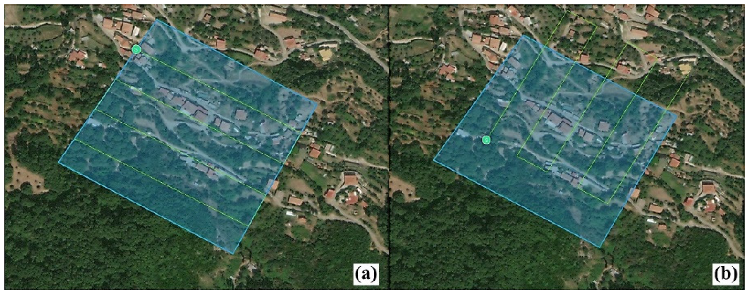
UAV imagery was obtained using a DJI Phantom 4, which is equipped with a built-in GNSS system and a CMOS camera (12.4 MP) with 4000 × 3000 resolution. Each case study consisted of three different flight grids (nadir, oblique, and nadir and oblique). During these distinct campaigns, flight characteristics were kept the same (Table 2). Specifically, flights were executed with a 90% along-track overlap and a 75% cross-track overlap. However, the flight acquisition altitude was adapted to the topography of each study area, with the aim of extracting photogrammetric products with spatial resolution between 2.3 and 3.5 cm (Table 2). The collected UAV imagery of each area was classified into three groups of data. The first group included nadir-only images with a 90-degree gimbal pitch angle; the second group consisted of oblique-only images with a 65-degree gimbal pitch angle; and a synergistic use of nadir and oblique imagery was selected for the third group.
In addition, GCPs were distributed throughout the survey areas in order to orient and match the aerial imagery to data measured terrestrially. GCPs were collected using a Leica GS08 GNSS receiver. Coded targets were created according to the general recommendations of Agisoft Metashape software [35], and were printed on matte finish plastic boards. These targets were used as GCPs (Figure 2). Furthermore, large rectangular aluminum targets were placed in the survey areas for comparison and validation of the photogrammetric outputs (Figure 3). These aluminum targets had specific dimensions and a hole in each corner, in order to be accurately measured with a GNSS sensor.

2.3. Methodology

The aim of the current study was to examine whether the geometry of UAV acquisition plays a key role in the accuracy of derived photographic products that are subsequently used as high-precision data for landslide mapping and monitoring. A schematic illustration of the applied methodology is displayed in Figure 4.
In more detail, UAV surveys were conducted over five study areas, presenting different characteristics (topography, land cover, etc.). Three UAV flights, consisting of: (a) nadir-only acquisitions, (b) oblique-only acquisitions, and (c) an integration of nadir and oblique acquisitions, were executed for each case study. The different UAV acquisition trajectories of nadir- and oblique-viewing campaigns over the landslide of Messarista (case study) are depicted in the Figure 5. It is worth mentioning that the collection of the oblique-viewing imagery was implemented as the UAV moved forward and backward, following line paths that were perpendicular to the slope of each study area. Furthermore, photogrammetric GCPs were collected during the UAV surveys.
The processing of the collected UAV imagery was carried out through SfM photogrammetry. The specific technique contributes to the three-dimensional reconstruction of the topography, using the basic principles of photogrammetry along with computer vision algorithms [36,37,38,39]. The main advantage of this functional and low-cost method is that it allows the automatic and simultaneous determination of scene geometry, camera positions, and orientation, without requiring pre-existing known points. Thus, multiple, overlapped and shifted 2D images are transformed into 3D representations using an automatic, feature-matching algorithm.
The photogrammetric processing of UAV imagery took place in Agisoft Metashape software. The calibration and optimization of the camera took place in accordance with Agisoft’s default values, as set for the DJI Phantom 4 camera. Internal orientation parameters were estimated automatically, due to the ability of the software to recognize the model of the camera and to specify the appropriate settings.
The high-quality option was selected for the alignment of the images, aiming at a more precise estimation of the camera positions [40]. At the same time, the processing of UAV imagery was implemented using the original image size. The quality option was closely linked to the quality of the topographic reconstruction. Moreover the, ultra-high setting was defined as the parameter during “build dense cloud” and “build mesh” procedures.
Orthophotos and DSMs emerged from the processing of the collected UAV imagery. These products were projected into the Hellenic Geodetic Reference System 1987. Specifically, three orthophotos and three DSMs were created for each study area, corresponding to the three different acquisition geometries (i.e., nadir-viewing images, oblique-viewing images, and an integration of nadir and oblique imagery). The evaluation of the accuracy of the generated orthophotos and DSMs was based on qualitative and quantitative comparative approaches, including RMSE calculation, length comparison, and mean center estimation.

3. Results

3.1. Accuracy Asssessment of Orthophotos

Three high resolution orthophotos were extracted from the photogrammetric processing for each case study, consisting of UAV data from the three different acquisition groups, i.e., (a) nadir-viewing imagery, (b) oblique-viewing imagery, and (c) the integration of nadir and oblique imagery. The aforementioned orthophotos, covering the area of case study 4 (Messarista), are depicted in Figure 6. As can be observed, a visual comparison between the orthophotos created by data for the different groups of geometry acquisitions is a particularly difficult task, due to apparent similarity.
In this context, the evaluation of the accuracy of the derived orthophotos was performed using comparison approaches in an ArcGIS environment. GIS applications have been utilized in respective studies for the characterization of geological features and geological mapping [41]. In this study, GCPs were utilized as precise reference positions. Then, two geodetic lines were shaped from the x-y coordinates of the GCPs of each study area. Figure 7 displays the reference geodetic lines, as formed for each case study. It is important to highlight that we tried to create the geodetic lines in different topographic reliefs, varying from steep slopes to flat regions. Subsequently, we digitized the same lines in all orthophotos, derived from the processing of the UAV imagery of all groups of acquisition geometry. The digitization of the lines was based on the visual identification of the respective GCPs, which were used to shape the reference geodetic lines. The length of each digitized and reference geodetic line were calculated and compared (Table 3). The length variations were significantly small, which proved the high accuracy of the photogrammetric products. In addition, the integration of nadir and oblique viewing acquisitions displayed the smallest length variations in eight out of ten comparisons, demonstrating the positive influence of the specific acquisition geometry on the enhancement of the accuracy of the derived orthophotos. Moreover, oblique-viewing geometry showed a better performance, compared to nadir-viewing acquisitions. In particular, the difference in the length of line 1, in comparison to the corresponding reference line in the case study of Zachlorou, was zero for the orthophoto resulting from the integration of nadir and oblique imagery. In addition, the variation for the nadir-viewing and oblique-viewing orthophotos was estimated at 0.190% and 0.067%, respectively. In the case of Egnemni, the percentage variations in line 2 were calculated at about 0.034% for the orthophotos that emerged from either the synergistic use of nadir and oblique images or the nadir-viewing imagery. In contrast, the corresponding difference for the nadir-viewing orthophoto was obviously larger (i.e., 0.228%).
The processing of nadir-viewing images, along with oblique imagery, enhanced the overall accuracy in all the investigated areas. In more detail, for nine of ten cases (Table 3) the length difference between the GNSS measurements and the measurements on the orthophotos was less than 0.05 m (5 cm). Taking into consideration the terrain steepness and the dense vegetation, we assume that the overall accuracy is excellent.
It is worth mentioning that even in the fifth test area (Patras Port), the combined processing of nadir and oblique images gave results that were more accurate than the single processing of nadir or oblique data. In detail, the length difference of the geodetic lines for the common data set was only 0.012 m (centimeter accuracy), while the respective accuracies for the nadir or oblique data set ranged between 0.12 m and 0.31 m (Table 3).
Another method, utilized for the evaluation of the accuracy of orthophotos resulted from the photogrammetric processing of each acquisition geometry, was based on the comparison of the mean center of the reference geodetic lines and the respective digitized ones. The mean center constitutes the geographical center of a set of features resulting from average x and y coordinates [42,43], which is calculated as:
X ¯ = i = 1 n x i n   and   Y ¯ = i = 1 n y i n
where xi and yi are the coordinates for a feature i and n is the total number of features. This approach is widely used for the identification of distribution changes or for the comparison of the distributions of features. The mean centers of the reference geodetic lines of each case study are depicted in Figure 7. The Near tool [44] was applied for the determination of the distance between the reference mean centers and the respective mean center of the digitized lines. Distance variations are displayed in Table 4. As can be noted, the multi-acquisition geometry (nadir and oblique imagery) presented the shortest distances from the reference mean centers in 50% of the UAV campaigns.
As a final comparison of the orthophotos derived from different acquisition geometries, we utilized the variations of the dimensions of the aluminum targets. These dimensional variations, regarding the orthophotos covering the landslide of Zachlorou, are presented in Table 5. As can be observed, the synergistic use of nadir and oblique photos increase the accuracy of the orthophoto. The true length of the aluminum target is 0.538 m and the respective measured value from the oblique and nadir imagery is 0.542 m, meaning that the overall difference is only 4 mm. The difference value for the nadir imagery is 8 mm and for the oblique imagery is 10 mm.

3.2. Accuracy Asssessment of DSMs

The evaluation of the accuracy of the extracted DSMs was executed through the computation of RMSE, which estimates the differences between the values of a DMS and the reference high-precision values. The computation is performed by the following equation:
R M S E = 1 n i = n n ( h r e f h i ) 2
where href is the reference elevation, hi is the DSM elevation at point i, and n is the number of GCPs. A basic condition for the performance of the calculation is that the reference data should be an order better than the data to be evaluated. Thus, GCPs with sub-millimeter accuracy were utilized as reference points in the current study.
The variations in the elevation values between the reference data and the respective photogrammetric DSMs, acquired by different viewing geometries over all case studies, are presented in Table 6. It is obvious that the synergistic use of nadir- and oblique- viewing images during UAV campaigns managed to minimize the elevation errors in most DSMs. In particular, the RMSE for the DSM arising from the combined use of nadir and oblique imagery in the case study of Egnemni, was calculated at 0.083 m, while the respective errors for the nadir-viewing and oblique-viewing DSMs were estimated at 0.092 m and 0.085 m, respectively. Furthermore, in the case study of Messarista, the RMSE for the DSM that emerged from the simultaneous processing of nadir and oblique imagery was calculated at 0.090 m. The respective RMSE for the nadir-viewing DSM was computed at 0.162 m, while the error of the oblique-viewing DSM was notably larger (i.e., 0.357 m).
Although oblique-viewing images demonstrated an overall good performance in the generation of DSMs, we noticed a correlation between the UAV acquisition geometry and the topographic characteristics of the survey area. Specifically, nadir-viewing geometry was considered more suitable for DSM generation in flat urban (case study 5) or densely built-up (case study 4) areas, since it revealed smaller values in elevation variations than oblique imagery.

4. Discussion

The capability of performing a high accuracy field campaign with excellent repeatability is the basic demand [45,46,47] for landslide mapping and monitoring for assessing any deformation, usually within a steep and possibly dangerous environment. Sub-centimeter accuracy is a prerequisite in both horizontal and vertical axes in order to assess the activity of a landslide. Aiming to develop a guideline for accurate landslide mapping, we conducted four repeated tests within four active landslides with diverse characteristics. Both the horizontal and the vertical accuracy of the orthophotos and the DSMs were examined.
It was proved that the combination of nadir and oblique imagery produced more accurate results in all the studied cases. This output was in full accordance with the results of a previous study [28] that mentioned that overall accuracy is increased by 50% when nadir and oblique imagery are combined. The statistical comparison of the length of the digitized geodetic lines demonstrated that the integration of nadir and oblique images provides orthophotos with higher accuracy. Oblique imagery seems to provide more accurate results than nadir imagery. The only exception was the Messarista case study, where the processing of the oblique images yielded the worst results, compared to the respective result from the nadir images. This can be justified, as Messarista is a densely built-up village on a steep hill with very narrow backstreets. These narrow side streets cannot be clearly mapped in oblique imagery. Furthermore, the houses are built side-by-side and the front buildings hide the back ones. As a result, nadir imagery provides useful information that cannot be derived from oblique imagery alone.
Similar results were extracted from the measurements of the near distances of the mean centers that were calculated in the ArcMap environment. In almost all the cases, the simultaneous processing of nadir and oblique imagery provided more accurate results. The same combination produced more accurate DSMs in all the study areas. As presented in Table 4, in very steep environments (the four landslide areas) and in a flat area (Patras Port), the vertical accuracy of the oblique-nadir DSM was higher in comparison to the accuracies of either nadir or oblique DSMs.
Summarizing the overall assessment of the results, based on the application of simple statistical calculations, it was proved that the synergistic use of nadir and oblique imagery was considered to be the most appropriate geometry at 80% (i.e., in eight cases), according to the comparison of the length of the two lines of the five study areas (i.e., 10 cases) (Figure 8a). Moreover, comparing only nadir-viewing and oblique-viewing geometry, oblique acquisitions provided more accurate results by 70% (Figure 8b). Figure 9 and Figure 10 display the corresponding evaluations using the comparison of near distances and RMSE calculation.
Our findings are in accordance with those of previous studies [20,21,24,25,26]. Specifically, nadir and oblique images were compared with TLS data for the mapping of a fault plane [20]. The tests proved that both precision and accuracy have been increased when the two sets of images were combined. It was marked [21] that the combined use of nadir and oblique imagery offers a valued methodology for open-pit operations and for the continuous monitoring of the exploitation by managers. UAV data acquired from oblique and facade viewing angles were compared with nadir images in a steep and complex mountainous terrain, and the produced point clouds were compared with TLS data [24]. It was proved that the combination of oblique and façade images, compared to nadir data, increased the geometric accuracy of the derived point cloud data [24]. In a respective test [25], it was demonstrated that the combination of nadir and oblique images ameliorates the accuracy of 3D surface models in an agricultural area when no ground control points or a small number of ground control points are used. Nadir and oblique imageries were compared for 3D building representation [26]. The results proved that oblique data ameliorates the obtainable accuracy of the derived point cloud and of the produced 3D model. As described in [28], supplementing nadir image blocks with oblique images consistently mitigates the systematic error patterns within complex topography. The results from many scenarios proved that the combination of nadir and oblique images increased precision and accuracy, and reduced data gaps. Those previous results are in full accordance with our results. In all the studied areas, it was also proved that the simultaneous processing of the nadir and oblique imagery decreases the RMSE error and increases the geometric precision.

5. Conclusions

The objective of the current study was to develop a guidance for accurate landslide mapping in steep terrains. In this context, we performed four identical tests within four active landslides spreading throughout Western Greece. The main conclusions that emerged from this research included the following:
  • It was proved that the acquisition of UAV oblique and nadir imagery and the synergistic processing increase overall centimeter accuracy.
  • In general, oblique imagery provides more accurate results in steep terrains compared to nadir imagery. However, in areas that combine high slopes, dense urban settlements, and narrow streets (as in Messarista village), nadir imagery could not be omitted.
  • Even in flat areas, such as Patras Port, the combined use of oblique and nadir imagery ameliorates the overall accuracy.
  • A UAV flight campaign should be adjusted each time to an investigated area’s characteristics and local topography.
  • In steep terrains, an average flight altitude between 70 and 110 m above ground level or a ground spatial resolution of around 3 cm are recommended for both nadir and oblique campaigns in order to assess centimeter accuracy.

Author Contributions

Conceptualization, K.G.N.; methodology, K.G.N. and A.K.; software, K.G.N. and A.K.; validation, K.G.N., A.K. and I.K.K.; formal analysis, A.K.; investigation, K.G.N., A.K. and I.K.K.; resources, K.G.N.; data curation, K.G.N., A.K. and I.K.K.; writing—original draft preparation, K.G.N. and A.K.; writing—review and editing, K.G.N., A.K. and I.K.K.; project administration, K.G.N. All authors have read and agreed to the published version of the manuscript.

Funding

This research received no external funding.

Institutional Review Board Statement

Not applicable.

Informed Consent Statement

Not applicable.

Data Availability Statement

The data presented in this study are available on request from the corresponding author. The data are not publicly available, due to privacy considerations.

Conflicts of Interest

The authors declare no conflict of interest.

References

  1. Van Westen, C.J. Remote sensing for natural disaster management. Int. Arch. Photogramm. Remote Sens. 2000, 33, 1609–1617. [Google Scholar]
  2. Garnica-Peña, R.J.; Alcántara-Ayala, I. The use of UAVs for landslide disaster risk research and disaster risk management: A literature review. J. Mt. Sci. 2021, 18, 482–498. [Google Scholar] [CrossRef]
  3. Salvini, R.; Mastrorocco, G.; Esposito, G.; Di Bartolo, S.; Coggan, J.; Vanneschi, C. Use of a remotely piloted aircraft system for hazard assessment in a rocky mining area (Lucca, Italy). Nat. Hazards Earth Syst. Sci. 2018, 18, 287–302. [Google Scholar] [CrossRef] [Green Version]
  4. Giordan, D.; Manconi, A.; Remondino, F.; Nex, F. Use of unmanned aerial vehicles in monitoring application and management of natural hazards. Geomat. Nat. Hazards Risk 2016, 8, 1–4. [Google Scholar] [CrossRef]
  5. Merdaway, A.; Guvenc, I. UAV assisted heterogeneous networks for public safety communications. In Proceedings of the IEEE Wireless Communications and Networking Conference Workshop—2nd International Workshop on Device to Device and Public Safety Communications, New Orleans, LA, USA, 9–12 March 2015; pp. 1–6. [Google Scholar]
  6. Xu, Z.; Yang, J.; Peng, C.; Wu., Y.; Jiang, X.; Li, R.; Zheng, Y.; Gao, Y.; Liu, S.; Tian, B. Development of an UAS for post-earthquake disaster surveying and its application in Ms7.0 Lushan Earthquake, Sichuan, China. Comput. Geosc. 2014, 68, 22–30. [Google Scholar] [CrossRef]
  7. Feng, Q.; Liu, J.; Gong, J. Urban Flood Mapping Based on Unmanned Aerial Vehicle Remote Sensing and Random Forest Classifier—A Case of Yuyao, China. Water 2015, 7, 1437–1455. [Google Scholar] [CrossRef]
  8. Liu, C.-C.; Chen, P.-L.; Matsuo, T.; Chen, C.-Y. Rapidly responding to landslides and debris flow events using a low-cost unmanned aerial vehicle. J. Appl. Remote Sens. 2015, 9, 096016. [Google Scholar] [CrossRef]
  9. Gomez, C.; Purdie, H. UAV-based photogrammetry and geocomputing for hazards and disaster risk monitoring—A Review. Geoenvironmental Disasters 2016, 3, 23. [Google Scholar] [CrossRef] [Green Version]
  10. Themistocleous, K.; Hadjimitsis, D.G.; Michaelides, S.; Spizzichino, D.J.; Crosta, G.B.; Fernandez Merodo, J.A.; Bee, E. Best practices for monitoring. mitigation and preservation of cultural heritage sites affected by geo-hazards. In Proceedings of the EGU2018, Vienna, Austria, 8–13 April 2018; Volume 20. [Google Scholar]
  11. Agüera-Vega, F.; Carvajal-Ramírez, F.; Martínez-Carricondo, P. Assessment of photogrammetric mapping accuracy based on variation ground control points number using unmanned aerial vehicle. Measurement 2017, 98, 221–227. [Google Scholar] [CrossRef]
  12. Oniga, V.-E.; Breaban, A.-I.; Pfeifer, N.; Chirila, C. Determining the Suitable Number of Ground Control Points for UAS Images Georeferencing by Varying Number and Spatial Distribution. Remote Sens. 2020, 12, 876. [Google Scholar] [CrossRef] [Green Version]
  13. Bolkas, D. Assessment of GCP Number and Separation Distance for Small UAS Surveys with and without GNSS-PPK Positioning. J. Surv. Eng. 2019, 145, 04019007. [Google Scholar] [CrossRef]
  14. Tonkin, T.N.; Midgley, N.G. Ground-Control Networks for Image Based Surface Reconstruction: An Investigation of Optimum Survey Designs Using UAV Derived Imagery and Structure-from-Motion Photogrammetry. Remote Sens. 2016, 8, 786. [Google Scholar] [CrossRef] [Green Version]
  15. Gindraux, S.; Boesch, R.; Farinotti, D. Accuracy Assessment of Digital Surface Models from Unmanned Aerial Vehicles’ Imagery on Glaciers. Remote Sens. 2017, 9, 186. [Google Scholar] [CrossRef] [Green Version]
  16. Taddia, Y.; González-García, L.; Zambello, E.; Pellegrinelli, A. Quality Assessment of Photogrammetric Models for Façade and Building Reconstruction Using DJI Phantom 4 RTK. Remote Sens. 2020, 12, 3144. [Google Scholar] [CrossRef]
  17. Žabota, B.; Kobal, M. Accuracy Assessment of UAV-Photogrammetric-Derived Products Using PPK and GCPs in Challenging Terrains: In Search of Optimized Rockfall Mapping. Remote Sens. 2021, 13, 3812. [Google Scholar] [CrossRef]
  18. Štroner, M.; Urban, R.; Reindl, T.; Seidl, J.; Brouček, J. Evaluation of the Georeferencing Accuracy of a Photogrammetric Model Using a Quadrocopter with Onboard GNSS RTK. Sensors 2020, 20, 2318. [Google Scholar] [CrossRef] [Green Version]
  19. Štroner, M.; Urban, R.; Seidl, J.; Reindl, T.; Brouček, J. Photogrammetry Using UAV-Mounted GNSS RTK: Georeferencing Strategies without GCPs. Remote Sens. 2021, 13, 1336. [Google Scholar] [CrossRef]
  20. Amrullah, C.; Suwardhi, D.; Meilano, I. Product accuracy effect of oblique and vertical non-metric digital camera utilization in UAV-photogrammetry to determine fault plane. ISPRS Ann. Photogramm. Remote Sens. Spat. Inf. Sci. 2016, 3, 41–48. [Google Scholar] [CrossRef] [Green Version]
  21. Rossi, P.; Mancini, F.; Dubbini, M.; Mazzone, F.; Capra, A. Combining nadir and oblique UAV imagery to reconstruct quarry topography: Methodology and feasibility analysis. Eur. J. Remote Sens. 2017, 50, 211. [Google Scholar] [CrossRef] [Green Version]
  22. Kyriou, A.; Nikolakopoulos, K.; Koukouvelas, I. How image acquisition geometry of UAV campaigns affects the derived products and their accuracy in areas with complex geomorphology. ISPRS Int. J. Geo-Inf. 2021, 10, 408. [Google Scholar] [CrossRef]
  23. Nesbit, P.R.; Hubbard, S.M.; Hugenholtz, C.H. Direct georeferencing UAV-SfM in high-relief topography: Accuracy assessment and alternative ground control strategies along steep inaccessible rock slopes. Remote Sens. 2022, 14, 490. [Google Scholar] [CrossRef]
  24. Tu, Y.-H.; Johansen, K.; Aragon, B.; Stutsel, B.M.; Angel, Y.; Camargo, O.A.L.; Al-Mashharawi, S.K.M.; Jiang, J.; Ziliani, M.G.; McCabe, M.F. Combining nadir, oblique, and façade imagery enhances reconstruction of rock formations using unmanned aerial vehicles. IEEE Trans. Geosci. Remote Sens. 2021, 59, 9987–9999. [Google Scholar] [CrossRef]
  25. Meinen, B.U.; Robinson, D.T. Mapping erosion and deposition in an agricultural landscape: Optimization of UAV imageacquisition schemes for SfM-MVS. Remote Sens. Environ. 2020, 239, 111666. [Google Scholar] [CrossRef]
  26. Vacca, G.; Dessì, A.; Sacco, A. The use of nadir and oblique UAV images for building knowledge. ISPRS Int. J. Geo-Inf. 2017, 6, 393. [Google Scholar] [CrossRef] [Green Version]
  27. Lingua, A.; Noardo, F.; Spanò, A.; Sanna, S.; Matrone, F. 3D model generation using oblique images acquired by UAV. Int. Arch. Photogramm. Remote Sens. Spat. Inf. Sci. 2019, 151, 146–152. [Google Scholar] [CrossRef] [Green Version]
  28. Nesbit, P.R.; Hugenholtz, C.H. Enhancing UAV–SfM 3D Model Accuracy in High-Relief Landscapes by Incorporating Oblique Images. Remote Sens. 2019, 11, 239. [Google Scholar] [CrossRef] [Green Version]
  29. Anis, Z.; Wissem, G.; Riheb, H.; Biswajeet, P.; Essghaier, G.M. Effects of clay properties in the landslides genesis in flysch massif: Case study of Aïn Draham, North Western Tunisia. J. Afr. Earth Sci. 2018, 151, 146–152. [Google Scholar] [CrossRef]
  30. Cushing, M. Evolution structurale de la marge nord ouest hellénique dans l’ île de Levkas et ses environs (Grèce nord occidentale). In Thèse 3me Cycle; Univ. de Paris-Sud: Paris, France, 1985; p. 67. [Google Scholar]
  31. Rondoyianni, T.; Mettos, A.; Paschos, P.; Georgiou, C. Neotectonic Map of Greece, Scale 1:100.000, Lefkada Sheet; I.G.M.E.: Athens, Greece, 2007. [Google Scholar]
  32. Tsangaratos, P.; Loupasakis, C.; Nikolakopoulos, K.; Angelitsa, V.; Ilia, I. Developing a landslide susceptibility map based on remote sensing, fuzzy logic and expert knowledge of the Island of Lefkada, Greece. Environ. Earth Sci. 2018, 77, 363. [Google Scholar] [CrossRef]
  33. Fernández-Blanco, D.; de Gelder, G.; Lacassin, R.; Armijo, R. A new crustal fault formed the modern Corinth Rift. Earth-Science Rev. 2019, 199, 102919. [Google Scholar] [CrossRef] [Green Version]
  34. Jolivet, L.; Labrousse, L.; Agard, P.; Lacombe, O.; Bailly, V.; Lecomte, E.; Mouthereau, F.; Mehl, C. Rifting and shallow-dipping detachments, clues from the Corinth Rift and the Aegean. Tectonophysics 2010, 483, 287–304. [Google Scholar] [CrossRef] [Green Version]
  35. Coded Targets and Scale Bars. Available online: https://agisoft.freshdesk.com/support/solutions/articles/31000148855-coded-targets-and-scale-bars (accessed on 1 March 2022).
  36. Westoby, M.; Brasington, J.; Glasser, N.; Hambrey, M.; Reynolds, J. ‘Structure-from-Motion’ photogrammetry: A low-cost. effectivetool for geoscience applications. Geomorphology 2012, 179, 300–314. [Google Scholar] [CrossRef] [Green Version]
  37. Eltner, A.; Sofia, G. Structure from motion photogrammetric technique. In Developments in Earth Surface Processes; Tarolli, P., Mudd, S.M., Eds.; Elsevier: Amsterdam, The Netherlands, 2020; Volume 23, pp. 1–24. [Google Scholar]
  38. Micheletti, N.; Chandler, J.; Lane, S.N. Structure from motion (SFM) photogrammetry. In Geomorphological Techniques; British Society for Geomorphology: London, UK, 2015. [Google Scholar]
  39. Clapuyt, F.; Vanacker, V.; Van Oost, K.; Clapuyt, F.; Vanacker, V.; Van Oost, K. Reproducibility of UAV-based earth topography reconstructions based on Structure-from-Motion algorithms. Geomorphology 2016, 260, 4–15. [Google Scholar] [CrossRef]
  40. Agisoft Metashape User Manual. Available online: https://www.agisoft.com/pdf/metashape-pro_1_7_en.pdf (accessed on 8 March 2022).
  41. Tamani, F.; Hadji, R.; Hamad, A.; Hamed, Y. Integrating Remotely Sensed and GIS Data for the Detailed Geological Mapping in Semi-Arid Regions: Case of Youks les Bains Area, Tebessa Province, NE Algeria. Geotech. Geol. Eng. 2019, 37, 2903–2913. [Google Scholar] [CrossRef]
  42. ArcMap (Mean Center). Available online: https://desktop.arcgis.com/en/arcmap/latest/tools/spatial-statistics-toolbox/mean-center.htm (accessed on 5 March 2022).
  43. Mitchell, A. The ESRI Guide to GIS Analysis, 1st ed.; ESRI Press: Redlands, CA, USA, 2005; Volume 2. [Google Scholar]
  44. ArcMap (Near Analysis). Available online: https://desktop.arcgis.com/en/arcmap/10.3/tools/analysis-toolbox/near.htm (accessed on 5 March 2022).
  45. Lucieer, A.; de Long, S.M.; Turner, D. Mapping landslide displacements using Structure from Motion (SfM) and image correlation of multi-temporal UAV photography. Prog. Phys. Geogr. 2014, 38, 97–116. [Google Scholar] [CrossRef]
  46. Bhardwaj, A.; Sam, L.; Akanksha; Martín-Torres, F.J.; Kumar, R. UAVs as remote sensing platform in glaciology: Present applications and future prospects. Remote Sens. Environ. 2016, 175, 196–204. [Google Scholar] [CrossRef]
  47. Eltner, A.; Baumgart, P.; Maas, H.-G.; Faust, D. Multi-temporal UAV data for automatic measurement of rill and interrill erosion on loess soil. Earth Surf. Process. Landforms 2014, 40, 741–755. [Google Scholar] [CrossRef]
Figure 1. Location of the five case studies within Greece and UAV orthophotos of each area of interest.
Applsci 12 04598 g001
Figure 2. Printed GCP pattern, distributed throughout the survey area during UAV campaigns.
Applsci 12 04598 g002
Figure 3. Aluminum targets, as captured in orthophotos during UAV campaigns over the landslide of Zachlorou.
Applsci 12 04598 g003
Figure 4. A flowchart showing the processing steps of the research methodology.
Applsci 12 04598 g004
Figure 5. UAV acquisitions over the landslide of Messarista. (a) Nadir-viewing acquisition trajectory; (b) Oblique-viewing acquisition trajectory.
Applsci 12 04598 g005
Figure 6. UAV orthophotos of the landslide of Messarista, emerging from the processing of (a) nadir-viewing images, (b) oblique-viewing images, and (c) synergistic use of nadir and oblique images. The scale of the orthophotos was set to 1:1500.
Applsci 12 04598 g006
Figure 7. Reference geodetic lines as created in: (a) case study 1, (b) case study 2, (c) case study 3, (d) case study 4, and (e) case study 5.
Applsci 12 04598 g007
Figure 8. (a) Overall assessment of the accuracy of the photogrammetric products in accordance with UAV acquisition geometry using length comparison; (b) assessment of the accuracy of the photogrammetric products using length comparison between nadir- and oblique-viewing geometry.
Applsci 12 04598 g008
Figure 9. (a) Overall assessment of the accuracy of the photogrammetric products in accordance with UAV acquisition geometry using near distances; (b) assessment of the accuracy of the photogrammetric products using near distances between nadir- and oblique-viewing geometry.
Applsci 12 04598 g009
Figure 10. (a) Overall assessment of the accuracy of the photogrammetric products in accordance with UAV acquisition geometry using RMSE; (b) assessment of the accuracy of the photogrammetric products using RMSE between nadir- and oblique-viewing geometry.
Applsci 12 04598 g010
Table 1. Selected case studies and characteristics (topography, vegetation).
Case Study IDLocationsTopography
Description
Vegetation
1MoiraSteep slope, large extent, grassland 1 Low and sparse vegetation
2EgkremniSteep slope, coastal area, grasslandVery sparse vegetation
3ZachlorouSteep slope, narrow gorge, grassland Low vegetation
4MessaristaSteep slope, urban settlement, narrow roads, densely build-up areaLow vegetation
5Patras PortFlat, industrial environment No vegetation
1 Based on coordination of information on the environment (CORINE) land cover classification.
Table 2. Characteristics and parameters of UAV campaigns.
Case Study IDAcquisition GeometryNumber of PhotosAverage Flight Altitude (m)Average GSD (cm)Along the Track Overlap %Along the Track Overlap %
MoiraNadir1891103.59075
Oblique174
Synergistic use363
EgremniNadir97602.39075
Oblique84
Synergistic use181
ZachlorouNadir60702.59075
Oblique210
Synergistic use286
MessaristaNadir651103.59075
Oblique70
Synergistic use135
Patras PortNadir96602.39075
Oblique85
Synergistic use181
Table 3. Comparison of the length of the geodetic lines of each case study in accordance with the respective reference length.
Case Study IDAcquisition GeometryLength Line 1 (m)Difference (m)Difference %Length Line 2 (m)Difference (m)Difference %
Reference line226.676 129.881
MoiraNadir226.933−0.257−0.113%129.5500.3310.254%
Oblique226.745−0.069−0.030%129.937−0.056−0.043%
Synergistic use226.734−0.058−0.029%129.7250.1560.120%
Reference line32.898 23.221
EgremniNadir32.8610.0380.112%23.274−0.054−0.228%
Oblique32.906−0.007−0.024%23.229−0.008−0.034%
Synergistic use32.8680.0300.091%23.229−0.008−0.034%
Reference line8.938 16.152
ZachlorouNadir8.9210.0170.190%16.179−0.027−0.167%
Oblique8.944−0.006−0.067%16.179−0.027−0.167%
Synergistic use8.9380.0000.000%16.177−0.025−0.154%
Reference line60.524 23.064
MessaristaNadir60.577−0.053−0.088%23.149−0.085−0.368%
Oblique61.002−0.478−0.790%23.299−0.235−1.018%
Synergistic use60.539−0.015−0.014%23.097−0.033−0.143%
Reference line84.240 74.220
Patras PortNadir84.559−0.319−0.379%74.492−0.272−0.366%
Oblique84.1170.1230.146%73.9880.2320.312%
Synergistic use84.2280.0120.012%74.2080.0120.016%
Table 4. Near distances of mean centers resulting from the reference mean centers of geodetic lines 1 and 2.
Case Study IDAcquisition GeometryNear Distance (m)
Mean Center of Line 1
Near Distance (m)
Mean Center of Line 2
MoiraNadir0.0230.095
Oblique0.0150.049
Synergistic use0.0130.012
EgkremniNadir0.0200.022
Oblique0.0250.014
Synergistic use0.0380.021
ZachlorouNadir0.0060.016
Oblique0.0700.068
Synergistic use0.0230.010
MessaristaNadir0.0640.036
Oblique0.4770.305
Synergistic use0.0820.034
Patras PortNadir0.7000.812
Oblique0.9460.890
Synergistic use0.0240.009
Table 5. Comparison of the dimensions of the aluminum target between the different acquisition geometries.
Case Study IDAcquisition GeometryLength
(m)
Difference (m)Difference %Area (m2)Difference (m2)Difference %
Reference0.538 0.150
ZachlorouNadir0.546−0.008−1.486%0.1490.0010.666%
Oblique0.548−0.010−1.858%0.1480.0021.332%
Synergistic use0.542−0.004−0.743%0.151−0.001−0.666%
Table 6. RMSE values emerging from the generated DSMs.
Case Study IDAcquisition GeometryRMSE (m)
MoiraNadir0.380
Oblique0.260
Synergistic use0.140
EgkremniNadir0.092
Oblique0.085
Synergistic use0.083
ZachlorouNadir0.506
Oblique0.498
Synergistic use0.475
MessaristaNadir0.162
Oblique0.357
Synergistic use0.090
Patras PortNadir0.159
Oblique0.236
Synergistic use0.047
Publisher’s Note: MDPI stays neutral with regard to jurisdictional claims in published maps and institutional affiliations.

