Article

Regional Infrastructure Planning Support Methodology for Public and Private Electrified Transport: A Mountain Case Study

1
Institute for Renewable Energy, Eurac Research, Viale Druso, 1, 39100 Bolzano, Italy
2
SynapsEES s.r.l., Piazza della Manifattura, 1, 38086 Rovereto, Italy
3
Department of Statistics and Operations Research, University of Barcelona, Campus Diagonal Sud, Building H. Av. Diagonal, 647, 08028 Barcelona, Spain
*
Author to whom correspondence should be addressed.
Appl. Sci. 2023, 13(12), 7181; https://doi.org/10.3390/app13127181
Submission received: 15 March 2023 / Revised: 10 June 2023 / Accepted: 12 June 2023 / Published: 15 June 2023
(This article belongs to the Section Transportation and Future Mobility)

Abstract

:
The European Union has seen a strong growth of electric passenger vehicles over the last decade. The steady increase in the number of electric vehicles requires a thorough examination of the current infrastructure and their future development, which are critical to the continuous market growth of this technology. The underdeveloped charging infrastructure is identified as one of the main barriers, next to the purchase price of electric vehicles. Thus, the infrastructure (supply side) and the vehicles (demand side) must coevolve and consider not only the quantitative balance between EVs and charging stations but the interlinkages with social, technical, and economic criteria for the overall system development. In this context, the methods presented in this paper address regional specificities when developing an integrated network of charging infrastructure for private and public passengers transport in an alpine region. The results of the application of the methodology to a mountainous area present the potential for replicability and highlight the importance of considering regional characteristics and of stakeholder involvement.

1. Introduction

The European Union has seen a strong growth of electric passenger vehicles over the last decade. Passing from slightly over 21,000 cars in 2011 to nearly 2.2 million cars in 2021 [1]. This is backed by a series of initiatives and declarations such as the intergovernmental Electric Vehicles Initiative (EVI30) [2], which sets a global target of at least 30 percent new electric vehicle sales by 2030, or the EV100 initiative grouping companies, which commit to 100% electric fleets by 2030 [3]. In addition, in the public transportation domain, the electrified bus sector saw a fast development. In fact, the number of buses on European roads increased from only 286 battery electric buses in 2011 to over 7350 in 2021 [1].
In this context, the main challenges faced by the manufacturers are the development of a mass market for electric vehicles and investments in modern technologies to overcome infrastructure barriers. The rapid increase in the number of electric vehicles in Europe requires a thorough analysis of the future development of infrastructure, which is critical to the continuous market growth of this technology. For this reason, the European Directive 2014/94/EU [4] and its forthcoming revision [5] require member states to ensure that charging points (CPs) for electric vehicles must be publicly accessible and provide sufficient coverage. Underdeveloped charging infrastructure is identified as one of the main barriers to EV market diffusion [6,7]. In the case of insufficient charging infrastructure, there is no guarantee of flexibility and convenience in energy supply, which makes EV driving less attractive.
To overcome these obstacles, the infrastructure (supply side) and the vehicles (demand side) must coevolve [8]. The sustainable development of EV infrastructures and their widescale adoption requires the combination of the quantitative balance between EVs and charging stations with social, technical, and economic criteria [9]. The shift in the paradigm of electrified transport user behavior [10,11] shows that infrastructure should be planned in consideration of particular points of interest (POIs), where flows of people are the most important, or in the case of battery electric buses, at points where it is needed and based on a multiplicity of factors (i.e., the driven route, timetable, bus performance, etc.) [12,13,14].
Therefore, the process of locating charging points for electrified vehicles is complex and involves multiple factors, as well as stakeholders, and it has a strong influence on the effectiveness and functionality of the entire electromobility system. In this context, the authors address regional specificities when developing a network of charging infrastructure for public and private passenger transport. The use of charging infrastructure at an extra-urban scale is based on the tendency of longer distances that need to be served with low-density service areas and with a smaller number of vehicles with respect to the urban scale. Based on the literature review conducted, several examples of analyses can be found for the development of charging infrastructure (charging points for private vehicles and buses) in urban areas, but very few focus on the regional scale with specific features that address mountainous contexts. In the present study, charging infrastructure for both private vehicles and public buses are considered. Currently, the two are treated separately. However, both require similar infrastructural and grid connection investments; therefore, in regional areas with the specificities mentioned above, the dual use of charging stations or at least planning for the charging locations of both types can allow a higher degree of utilization of the infrastructure and thus enhance the efficiency of the investment, especially when it comes to publicly funded infrastructure. The paper also integrates considerations regarding the total cost of the infrastructure installations and the economic efficiency of public versus private investments in such infrastructures. The main advantage of the presented approach is the proposed spatially explicit methodology that can be practically implemented for regional planning purposes to improve the charging infrastructure for private and public passenger transport at the same time. This research can inform and support policymakers to foster the larger-scale deployment of charging infrastructure for EVs, allocating public resources efficiently and contributing to the present effort of reaching the decarbonization targets. The research also aims at offering a basis for further spatially explicit analysis targeting electric mobility and assisting regions similar to the case study for what concerns the characteristics of their socio-economic and transport system.
The work presented in this paper was developed within the framework of the two projects. The MOBSTER project “Electric mobility for sustainable tourism” (2019–2022) is an EU-funded project within the Interreg Italy-Switzerland Cooperation Programme. The main project aim is to encourage the spread of electric mobility and promote sustainable tourism in cross-border regions of Italy and Switzerland. One of its specific goals is to investigate the need for electric mobility infrastructures for private transport (electric passenger vehicles and e-bikes for individual use). The second project, “Evaluation of different scenarios to switch the regional bus fleet of an Italian alpine region to zero-emission buses” (2020–2021), was commissioned to Eurac Research by STA—Strutture Trasporto Alto Adige S.p.A.—to analyze the feasibility of replacing the whole provincial bus fleet (around 750 buses) with zero-emission buses. Following this request, the need for locating the charging infrastructure was also analyzed.
The paper is structured as follows: in Section 2, the literature review on the main relevant issues is listed, followed by a brief description of the case study in Section 3, and the presentation of the analytical methodology in Section 4. The results are described and discussed in Section 5, and the conclusions are presented in Section 6, followed by a brief outlook of the next steps in Section 7.

2. Literature Review

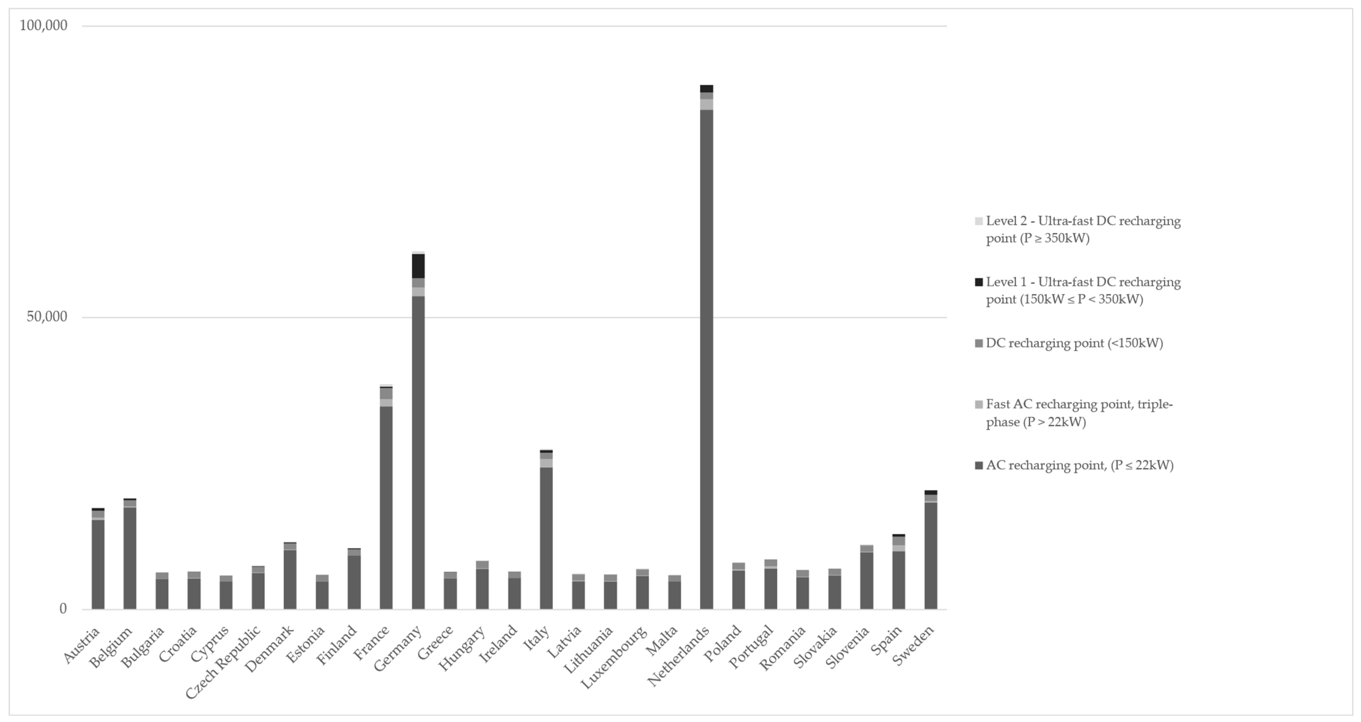
2.1. Trends in Charging Infrastructure Development of Private and Public Passenger Transport at the Regional Level

There are a number of charging stations of different types that have been installed in the last decade in European Union, ranging from a few kW to 475 kW. Several incentives for the installation of charging infrastructure, both public and private, for electric vehicles have been introduced and are being assessed as to their effectiveness [15]. In the EU, countries such as the Netherlands, France, Germany, and Italy show the highest numbers (as shown in Figure 1), and there has been continuous and rapid growth in recent years.
This is supported by the forthcoming revision of the Alternative Fuels Infrastructure Directive [5], which aims at introducing binding targets for electric vehicle charging points in EU27, with the current regulation recommending that there should be at least 1 recharging point per 10 cars [4]. Despite the growing need for charging stations corresponding to the growing electric vehicle numbers, access to public charging stations is limited compared to conventional fueling stations. Another current trend is the uneven geographical distribution of charging stations for EVs. In Italy, for example, 57% of those are located in the North, while 23% are in the Central, only 20% are in the South and the Islands, and 34% are in the regional capitals [16].
Technologically, the trends for the new types of charging stations consist of increasing the power transmitted and vehicle-to-grid (V2G), enabling them to be able to provide axillary services, and improving power quality for the distribution system operators [17]. Inductive power transfer, which is one of the wireless energy transfers, is seen as another trend within charging systems for EVs that would allow potentially extending an EV’s battery charge in dynamic charging [18]. Mobile charging stations is another technological possibility that is being introduced to equip areas with weaker grid connections or those were such connections are absent [19].
For electric buses, one trend is the development of the network of conductive charging technologies (pantographs or charging through the plug), which is considered to be more mature, with the possibility to transfer up to 600 kW [13,20]. Another charging technology for buses involves providing less power at a higher infrastructural cost; this is an inductive technology, which has a lower visual impact compared to pantographs. Dynamic wireless charging technology was shown to be more cost-effective with larger bus fleet sizes than small fleets [21]. There are significantly growing numbers of electrically chargeable buses in Europe (+78.7% in 2021) and a market share of 10.6% [22], which will require the development of adequate infrastructure at the regional level considering geographical, extra-urban, and urban constraints, as well as the clarification of the responsibilities for the development of such infrastructure and research on new business models.
Another innovative concept in electric vehicle charging infrastructure for e-buses is the shared infrastructure with other operators. This has been implemented via a second external charging point, which is not in conflict with the first charging point dedicated to the bus service only. Bus charging has priority, so if a bus passes by and charges for some minutes, in this time frame, the secondary charging is paused [23].

2.2. Methods Used for the Location of Charging Infrastructure for Private Passenger Vehicles

Moving from a fleet of fossil-fuel-based vehicles to a fleet of zero-emission vehicles in urban and non-urban contexts could foster a more sustainable future. Electric vehicles (EVs) should therefore be given priority so that they can gradually replace conventional vehicles. In this framework, it is essential that the charging infrastructure can support EVs and ensure the overall functionality of the system [24].
A well-planned network of charging stations (CSs) is a key element for the diffusion and utilization of EVs. Mirroring this importance, several scholarly studies focus on the analysis of the development of charging infrastructures. Scholars investigate the problem of finding suitable locations for public EV charging stations from different points of view. On the one hand, the issue is addressed only as a mathematical problem. For instance, a multi-agent system (genetic algorithm using a utility function) is developed by [25] to analyze the potential location for EV charging stations. Their method characterizes the areas where future CSs could potentially be located, integrating information from various data sources (i.e., traffic, social networks, population, etc.) as a baseline.
The issue of the distribution of EV charging stations is mainly an allocation problem, influenced by several criteria [24], which are likely in conflict and constrained by different variables (space, cost, coverage, energy availability, etc.). There are studies that apply mathematical methods and optimization models to solve this problem, whereas some research focuses on CP location analyses that are also based on multi-criteria and/or Geographic Information System (GIS)-based methods. The authors of [26] analyzed the associations between information on points of interest (POI) at a large urban scale and existing CP locations, exploiting the potential of big data. Based on this analysis, they calibrated the spatial distribution of EV charging demand. Applying a simple linear regression model that associates the use of existing CPs with the density of different POI categories, the authors selected the most statistically significant POI categories for what concerns the influence on EV charging demand. Reference [27] applied a geospatial analysis for the allocation of charging infrastructure for EVs within a city (positioning CSs along the urban road network) and a region (considering rural roads and motorways), relying on open-source GIS tools. Their methodology provides the optimal locations of EV charging stations for both types of networks, identifying areas with a high potential for CS installation. The combination of spatial statistics and a maximum-coverage location model is performed in the approach developed by [28] for the optimization of the placement of EV charging points to maximize the demand coverage. The method identified possible drivers for CP locations, highlighting the potential spatial diversity and the dependency effect among drivers. The authors of [29] focused on two other relevant aspects: CO2 emissions due to the round trips to CSs and constraints for the charging due to the remaining electricity. According to the authors, these two features can influence drivers’ location choices and charging decisions. In this study, an optimization approach is proposed to address the location issue, investigating the impact of travel data (GPS-enabled trajectory data) in different periods on CS location solutions. The authors of [30] elaborated a method to deploy charging stations and meet both the inter- and intra-city charging demand, considering existing and future charging installations. The developed method is based on a weighted multi-criteria analysis of roads that identifies several variables (demographic, economic, environmental, and transportation-related), as well as the available POIs that influence the potential use of charging stations.
Finally, there are studies that combine quantitative and qualitative methods for the deployment of charging infrastructure. For instance, [31] performed an online survey to gather information on the user requirements and preferences related to the charging process, the locations of fast-charging stations, and the weighting for the evaluation of the applied criteria. According to their study, additional services, accessibility, and reliability are the most important aspects to be considered when planning a charging station since they have strong influence on its use. Reference [24] applied a mixed approach that includes (i) a systematic literature review, looking for the spatial criteria that have been previously analyzed in similar studies; (ii) semi-structured interviews with relevant stakeholders (e.g., policymakers, planners, and market experts) to determine a set of criteria to be applied in the case study; and (iii) an Analytical Hierarchy Process (AHP) a multi-criteria analysis method, to define the criteria and related weights to estimate the suitability level of each road link for the CS’s location.
Focusing briefly on the use of POIs, in [25], a set of points (taken from the urban development plans) was used in the genetic algorithm at the beginning of the process as candidate locations for a charging station. Then, the algorithm performed a clustering analysis to remove the closest points and to define the area of influence of each point. In [26], the selected POIs characterized differences in urban land use (e.g., business, shopping, and recreational areas) and were considered the potential destinations for the daily travel of residents. The method in [28] was based on a set of large-scale urban POI and other data sources; the results show that the density of three POI categories (i.e., transport, retail, and commercial) is statistically associated with the charging demand. The authors of [30] developed a weighted multi-criteria method identifying attributes mainly related to economic, environmental, demographic, and transportation data, as well as the availability of POI influencing the potential use of charging stations.
Table 1 provides a classification of the reviewed literature based on the main methodology used for the analysis.

2.3. Public Charging Infrastructure Spatial Allocation Methods

The requirements and needs for charging infrastructure are mostly addressed by scholars in the research on and management of electric passenger vehicles and light-duty ones. At the same time, the literature on the methodologies addressing the needs of infrastructure planning for heavy-duty electric buses focuses mostly on the analysis at the urban scale. In comparison to location methods for private passenger charging stations, the ones for buses are mostly quantitative ones that can be classified into optimization models based on various factors and the analysis of geospatial characteristics (Table 2). The authors of [32] used a mathematical cost-minimization method as pure economic optimization is not suitable due to several non-economic factors involved in charging infrastructure planning. They considered such variables as onboard bus batteries and buses, together with charging infrastructure, when deciding on the suitability of a location.
References [33,34] proposed using a mixed integer linear model for the analysis of multiple bus routes at the urban level in Salt Lake City (USA) and Berlin (Germany), respectively. Reference [35] used a similar a mixed integer linear cost optimization model to analyze the potential for the substitution of traditional public transportation modes by barouches with electric buses, using a function of the least energy-consuming routes. The authors of [14] analyzed public transport electrification potential at urban level in Stockholm with the identification of potential charging locations using a mathematical cost- and energy-optimization and a geospatial analysis using ArcGIS. Lately, a mixed type of analysis has been introduced that also considers expert opinion integrated with spatial and economic analysis [13]. These scholars also note that more mixed qualitative–quantitative types of decision-making systems for the localization of charging stations for electric buses is needed, considering the complexity of such installations.
Table 2. Methods used for the location of electric bus charging infrastructure. Source: own elaboration.
Method/Approach ClassificationReferences
Quantitative
Mathematical cost minimization[14,32]
Mixed-integer linear optimization [33,35]
Spatial analysis[12,14]
Mixed
Spatial analysis/expert assessment [13]
To the authors’ knowledge, the only study addressing the location of charging infrastructure at the regional level was performed by [12]. They developed a model that considers distinctive spatio-temporal characteristics and difficulties associated with longer-distance operation of battery-electric buses. The model suggests a potential for the optimization of investment based on a variety of strategies that can be adopted by public transportation operators operating at the regional level for charging infrastructure based on operation characteristics specific to electric buses.

3. Case Study

Located in the Italian Alps, South Tyrol has a mountainous landscape (Figure 2). Around 60% of the area is located above 1500 m a.s.l., and only 4% of the area is located below 500 m a.s.l. This area was assessed as being one of the lead markets for electric and hydrogen fuel cell vehicles [36]. The low-carbon electricity mix and, in particular, the net electricity generation of renewable energy sources is one of the main indicators of the sustainable lead markets for EVs [37]. Considering its renewable electricity mix (89.9% from hydropower in 2020 [38]), it is compatible with the sustainable introduction of electrified transport. In addition, there is a high GDP/capita and established plans for the CO2 reduction of the transport sector down to climate neutrality by 2040 [39]. The regional government provides direct incentives for EV purchase and continuously improves and enlarges the network of charging points together with the regular campaign for vehicle test drives to citizens and companies. Private passenger vehicles, public buses, and bicycles are the preferred means of transport, representing 36%, 15.5%, and 13.9%, respectively [40]. The total number of electric vehicles registered in South Tyrol in 2021 reached 4438 (including 60 electric buses) and approximately 300 public charging stations [41,42].

4. Methodology

4.1. Public Charging Infrastructure Spatial Allocation Methods

The datasets used to assess the needs of electric mobility infrastructures for private EVs and e-bikes are (i) the vector map, with the transportation network infrastructures retrieved from the provincial geodatabase, (ii) the vector map with the existing charging points for EVs and e-bikes provided by project partners, and (iii) the vector map with the selected categories of POIs retrieved from the OpenStreetMap geodatabase.
The datasets used to assess the needs of electric mobility infrastructure for public buses are (i) the Digital Terrain Model (DTM with a spatial resolution 2.5 × 2.5 m) to provide information about the slope and elevation difference for each bus line, (ii) the vector map with the transportation network infrastructures, and (iii) the bus lines time schedule available in the General Transit Feed Specification (GTFS (https://gtfs.org/ (accessed on 24 May 2022))) format provided by STA—Strutture Trasporto Alto Adige S.p.A.

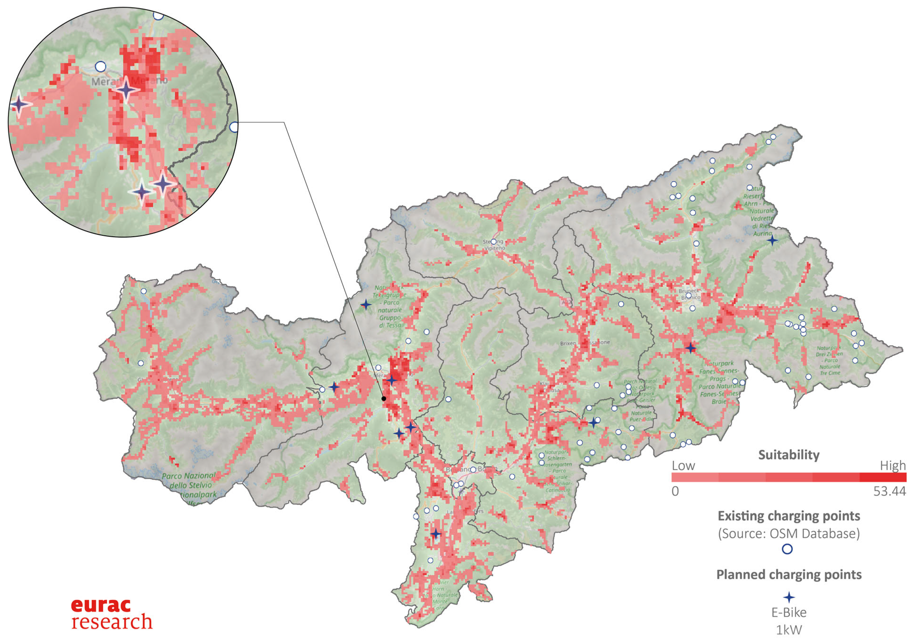
4.2. Data Processing and Analysis

For the localization of charging points targeting private EVs and e-bikes, a spatial analysis was performed to detect suitable areas for the installation of charging points for EVs and e-bikes for individual use and to improve the capillarity of the network.. To do this, the authors adopted and adapted a method for the allocation of charging infrastructures jointly developed by [27] (see Figure 3).
As illustrated in the flowchart, the first step of the analysis was to partition the territory into cells of equal area and shape. This process, called “tessellation”, is used to compare different data for mapping because it allows one to normalize geographies [43]. The tessellation can be of equilateral triangles, squares, or hexagons, as these three polygon shapes are the only three that can create an evenly spaced grid [43]. In this case, the authors decided to use hexagons, because this option is the best one to minimize the inevitable errors linked to the normalization of a spatial distribution [44]. In fact, hexagons have the lowest perimeter-to-area ratio and can reduce the sampling bias due to the edge effects of the grid shape [45].
Then, the hexagon grid was filtered by (i) selecting the cells intersected by the transportation network (given by municipal, provincial/regional, and national roads in the case of EVs and by cycleways and municipal roads in the case of e-bikes) and (ii) excluding the cells within a certain distance from existing charging points (a buffer of 5 km was considered in the case of EVs and of 2 km in the case of e-bikes).
The remaining cells represent areas with potential infrastructure needs. However, not all of them are suitable for the installation of new charging points. Usually, the spatial distribution of infrastructures is not homogeneous in the territory, but it is strongly correlated with the spatial distribution of POIs [46]. According to OpenStreetMap Wiki, a POI is a specific point location that someone may find useful or interesting and that may therefore attract people. Since a POI affects the suitability of areas for the installation of the new infrastructures, the most relevant ones in terms of private electric mobility were included in the analysis and were grouped into three categories according to their general function (see Table 3).
These POI may not have the same influence on the allocation choice, as, for example, higher importance of accommodations for the development of infrastructure. In order to solve this issue, an expert-driven approach was used. An evaluation questionnaire was designed and administered by an online tool to the project partners (6 representatives of the case studies) for the attribution of a subjective score between 1 (minimum) and 5 (maximum) at each POI and at each POI category. The averages of the scores (see Table 3) were included in the (experience-based) calculation process to properly weigh the different influences of POIs on the allocation choice.
Specifically, first, the command “Spatial Join” was used to join attributes from point-type layers (POIs) to polygon-type layers (hexagon grids) based on their spatial relationship. Then, these vector data were converted into raster data with the command “Polygon to Raster”. Lastly, the command “Raster Calculator” was used to build and execute the following map algebra expression:
{ [ k = 1 9 ( z k × k ) ] × x 1 } + { [ k = 10 14 ( z k × y k ) ] × x 2 } + { [ k = 15 18 ( z k × y k ) ] × x 3 }
where
  • x = a v e r a g e   s c o r e   o f   P O I   c a t e g o r y
  • y = a v e r a g e   s c o r e   o f   P O I   s u b c a t e g o r y
  • z = n u m b e r   o f   P O I   p e r   s u b c a t e g o r y
The output consisted of two different suitability maps, one related to the needs of electric infrastructures for private EVs and one for e-bikes.
For the analysis of localization of charging points concerning public buses, a dedicated Python (3.10) [47] code has been developed; the repository is publicly available [48]. The code was developed and tested in a Linux environment. The Digital Terrain Model (DTM) was combined with the transportation road network to characterize the bus line slope and elevation; this task was performed using GRASS GIS (8.0) [49]. Since there are several infrastructures (such as tunnels, bridges, etc.) that might falsify the actual elevation of each element, the authors applied a 10 m buffer around specific infrastructures, and the elevation on these areas have been linearly interpolated to assess the road elevation. Furthermore, the roads have been recursively interpolated, removing all the points with a slope greater than a 20%. The output of this task was a clean 3D vector map of the regional roads.
The road network and the bus time schedule were not always consistent; thus, the spatial position available in the GTFS file has been moved to the closest point of the road network. The authors built a simulation model that creates a physical energy balance. The model considers the road distance and the elevation difference performed by the bus within a specific bus line:
E tot = E dist + E up E down
where
  • E dist = bus   consumption × distance / η clima
  • E up = 9.81 × ( W bus + W people ) × Δ up / ( η up × η clima )
  • E down = 9.81 × W bus × Δ down × η down × η clima
With Δup and Δdown as positive and negative elevation differences, ηup = 0.85 (1) is the motor-to-wheel efficiency, ηdown = 0.40 (2) is wheel-to-motor efficiency, ηclima = 0.75 (3,4) is the reduction in bus autonomy to maintain the comfort conditions within the bus during winter/summertime. Wbus and Wpeople are, respectively, the weight of the bus and the maximum weight of people that might use the bus. The analysis was performed by selecting a specific day for the simulation (i.e., 29 January 2020), which was considered a representative winter day by the bus fleet owner. The simulated electric fleet consists exclusively of electric buses, with a battery capacity of 660 kWh. When the bus starts, the battery has a state of charge (SoC) of 90%, and the line is assigned to the bus only if the bus has enough energy to complete the bus trip. In case the bus does not have enough energy, it is stopped to be recharged, and a new one is generated with a 90% SoC, as a substitute for it. The simulation considers three different recharging logic for the buses:
  • The first option consisted of simulating a bus fleet that is charged only during the night, or during the day with a single long charge. As an example, the analysis performed for one representative line is reported in Figure 4, considering two electric buses (identified by the red and the blue color) that run two different routes of this line. In the figure, the solid line represents the going, the dashes represent standing at bus stops, and the dotted lines represent the return. It can be observed that buses run out of battery power almost completely at the end of the day, but they can still meet the requirements without recharging.
  • The second simulated option consists of the following: if the energy level is not enough but the bus stops at the bus stop for more than 10 min and the battery level is below 40%, the energy bus level is increased by the number of kWh per minute that can be transferred from the electric network to the bus battery. The authors considered the energy that can be transferred from the electric grid to the battery as follows:
E fromgridtobattery = P o w e r × t i m e × r e c h a r g e   e f f i c i e n c y
where Power is the power of the recharging point equal to 150 kW, time is the number of seconds that the bus is connected to the grid, and the recharge efficiency is the efficiency to recharge the battery and was considered equal to 0.95, as can be seen from Figure 5.
  • Third option: simulated diesel buses, creating their equivalent electric bus with an unrealistic battery capacity of 2.5 MWh. In this case, the two diesel buses running on two different routes do not need to be recharged on the way.
With the described simulation tool, it was possible to assess the energy that the grid needs to provide in a defined position to guarantee the bus service. More details on the consumption calculation can be found in [50]. It should also be noted that the authors followed a conservative approach, i.e., assumed high energy consumption by the buses.
There are three types of approaches that are generally used by the providers regarding the installation and management of the tourism-related electric vehicle infrastructure: (1) the direct installation and management of the charging point in highly frequented locations, (2) the installation based on business-to-business agreements with tourism-related corporate clients (e.g., restaurants, hotels), and (3) the installation of infrastructure in the locations with relatively weak demand (mostly on request of public authorities to ensure the homogeneity of the infrastructure of a given territory and the equality of access). In this paper, we focus on the first option for analysis. Recent analysis has shown that the utilization of a charger is hyperlocal and that the identification of the most popular sites early on can offer competitive advantage to a service-providing company [51].
Regarding the total cost of the installations of each type of charging infrastructure considered for planning, based on the consultations with the charging provider companies, the following costs are assumed (Table 4).

5. Results and Discussion

The work presented for the location of charging points targeting private EVs and e-bikes for individual use and public buses describes a methodology for charging stations in a mountainous area, supporting the territorial planning of electric mobility and the potential for integrated planning for such infrastructures. The authors developed a region-based approach to identify potential hot spots for the allocation of this infrastructure, considering key aspects of tourism demand, e.g., amenities and accessibility. This can be helpful in overcoming potential barriers related to the implementation of new infrastructures, such as the lack of cooperation and the limited coordination among different actors. The method aims to improve the extension and capillarity of the charging network, allowing the identification of the most suitable positions and preventing the risk of overlap installations.
According to the results of the analysis, suitable areas for the installation of new charging points for EVs are mostly located in the inner parts of the province (see Figure 6). In fact, South Tyrol already has a well-established infrastructure that covers the majority of the provincial territory. Therefore, in some cases, new inlets have been placed in areas with no charging infrastructure yet (but also less traffic); in other cases, the new infrastructure has been set in proximity to existing ones with the purpose of creating charging hubs based on high utilization rates and high traffic (e.g., in industrial or commercial parking lots). In total, within the MOBSTER project, 15 charging points for EVs have been installed in South Tyrol (5 Fast, 10 Quick).
Regarding e-bikes, results show that suitable areas for the installation of new charging points are widespread throughout the whole province (see Figure 7). In this case, the infrastructure is much more limited, and this does not imply that there are a small number of users (which in South Tyrol is higher than the national average) but that most of them are residents. However, with the strong development of the e-bike phenomenon, tourism-oriented locations such as South Tyrol have to proactively manage challenges and opportunities associated with this growth by adapting charging infrastructures to tourists’ needs and in order to further enhance the attractiveness of the region for this target group. In this case, within the MOBSTER project, nine e-bike charging points have been installed in South Tyrol.
The simulation tool for the localization of charging points concerning public buses provides the number of buses that are necessary to guarantee the regional bus service. Based on the energy balance of the battery while running through the routes under unfavorable conditions (with respect to climate and bus load), the bus lines were classified as follows:
  • Routes that can be satisfied with a single recharge during a night at the depot (depot charging);
  • Routes that can be satisfied only by using multiple recharge options, i.e., during the night in the depot, as well as when the bus stop is longer than 10 min and when the battery level is lower than 40% (opportunity charging);
  • Routes that can be satisfied only by using multiple recharge options as in (ii), as well as by increasing the number of buses to guarantee the service (this is the case if the time table is too tight in order to allow the bus to recharge the necessary energy in order to run through the whole route several times during the day).
According to the simulations, 24.7% of the bus lines can be performed by a fleet of buses with a single recharge during the night (depot charging); 53.6% can be covered by buses that also use one or multiple recharges during the day (depot + opportunity charging); the remaining 21.7% of the bus lines are required to increase the number of buses to guarantee the same service. Furthermore, the simulation tool identified 223 locations for bus charging points necessary to guarantee regional service. The number decreases to 95 if the bus charging points are clustered when the distance between the charging point locations is under 500 m. The total energy provided by the charging points is 83 MWh/day. In Figure 8, the location of the potential charging points is shown. Furthermore, the charging points are shown in different colors depending on their energy delivery to the buses per day (considering a typical week winter day as reference day).
The presented simulation tool was specifically developed to consider the energy penalties and specificity of the alpine area and to include the impact that the winter conditions might have on the bus autonomy and, more in general, on the whole regional service. The regional service is characterized by longer bus routes that range from a few kilometers to 57 km for a single one-way route and with an elevation difference up to 1750 m. All the bus routes of the regional service have been simulated to consider that the regional infrastructure is required to maintain and guarantee the public service. The regional routes serve low-density areas that might need to be modified and adapt the electric grid infrastructure to be able to insert a bus recharging point.
In Figure 9, the layers of the suitability of EVs and buses for charging stations overlap, and a charging hub cluster of 3 km around the potential bus charging stations is shown. As can be seen in some cases, the charging station is self-standing and a combination with a bus charging station is not possible (e.g., second cluster from right); however, in other cases, bus and EV charging stations are on the limit of such a cluster (e.g., the first cluster from the right) or they are nearly overlapping (e.g., the first three clusters from left). In such cases, at least an evaluation of a shared charging station could be considered, especially if the charging station is in remote areas where low charging frequency from EVs and buses is to be expected (e.g., the first and second charging stations from the top).

Costs and Economic Efficiency of Future Publicly Accessible Charging Infrastructure

In order to assess potential future costs needed to cover the case study region with the infrastructure for e-bikes and electric cars, the areas with medium–high suitability were extracted. Specific values are indicated in Table 5.
The economic efficiency for the charging point operator is directly dependent on the amount of electricity transferred through the charging station. Based on the information collected from the charging point operators, 5–6 daily charging sessions are needed for the profitability of a 22 kW AC charging station. Charging infrastructure in such locations can therefore be advised to be installed at the expense of the private operators. Although the cost of an e-bike charging station is around 30% of the cost of that of an e-car, the electricity consumed via this station is only around 1% of an e-car station (considering an average battery size of 60 kWh for e-cars versus 0.6 kWh for e-bikes). In this case, economic efficiency cannot be achieved through electricity sales. Cases where the installation of such charging stations is considered by the private operators are as follows: there is a commercial operator interested in attracting e-bike riders (e.g., restaurants, caffes, and shops) or the e-bike station is realized at the same location and under the same point of electricity delivery as an e-car station and is considered as an additional service for clients and as possibility to enhance the attractiveness of an e-car station. While public authorities fund the realization of the station in order to increase the use of an e-bike. The evaluation of the economic efficiency and investments for the relevant infrastructure installation for the e-bus charging points is different. A certain number of charging stations are needed to guarantee the interoperability of a public bus service.
The lower the number of needed charging points per bus and the higher the utilization rate of the single station, the higher its economic efficiency. Therefore, the first choice will be the bus depots or bus stops of multiple lines, where the charging stations can be used by more than one bus. If additional charging on single routes is needed, such stations will be used only by the buses serving this specific route. In suitable positions (Figure 9), integrated charging stations would yield higher economic efficiency, as external clients (e-cars) can use the station and enhance the daily utilization rate. The result of the present study suggests that in 13 out of 95 locations for bus charging stations, such an integrated solution can be attractive.

6. Conclusions

Charging stations for electrified vehicles (EVs) are the key element to allow the development of a zero-emission transport system. Therefore, an effective method to support the planning of charging stations, not only in the urban context but also at a regional scale, is crucial for EV-related growth. The correct positioning of charging infrastructure grants the optimization of operations and operative costs for both electric vehicles and electric buses. There are still some barriers to overcome along this pathway; in the presented study, the authors highlighted the main lessons learned in developing methods to analyze and simulate the charging infrastructure expansion at the regional scale, and specifically in a mountainous context, given the technological constraints of the current battery technologies.
The range anxiety phenomenon has been shown to be one of the main barriers, and this emphasizes again the relevance of the charging infrastructure that needs to anticipate the vehicles’ development. Therefore, it is important to locate charging points in both well-visited locations (with a high expected degree of utilization) and remote areas (with a low expected degree of utilization but that might be crucial for single users in order to be able to continue their journey) to guarantee the service.
Another relevant issue that emerged during the implementation stage of both methods is that several stakeholders should be involved in a very early phase for a successful charging network development, as it involves the need for permits, urban and regional plan adjustments, grid connections, and decisions for the ownership of the charging points.
Regarding the charging infrastructure for buses running regular routes, a detailed analysis of routes, considering distance and climatic conditions, and in mountainous areas as well as elevation (considering driving up the energy consumption and the possibility of energy recharging while driving down), is needed in the early phase of the BEB system development. This analysis requires a careful analysis of each single route individually. Further, the joint development of charging hub sites that integrate charging points for EVs and electric buses in extra-urban environments based on the indication given in this work can be considered in the location of remote areas with low charging frequency or in order to optimize investments for the development of charging sites.
In this framework, both the presented methods can be used as separate or single decision-support tools by decision-makers in planning effective and integrated charging infrastructure for private and public electric means of transport at the regional scale, also considering additional criticalities arising from regions located in mountainous areas. Further, an initial analysis of the investment costs that would be needed to further develop a homogeneous coverage for the whole territory. Such costs should be divided between the public and private sector in order to support the development of zero-emission public transport infrastructure and ensure that the weak charging-demand areas are provided with the infrastructure. In several cases, such investments can be optimized through the installation of the integrated charging points with on-the-go e-bus and e-car hubs. A detailed analysis involving relevant stakeholders using this methodology would allow the optimization of investments from private and public funding. Thus, the analyses described in the present study are seen as complementary.

7. Outlook

This paper is the first in a series of analyses that have been performed in the framework of several EU-funded projects aiming at introducing electrified vehicles and charging infrastructure in different sectors. The analyses performed and the methods presented in this study can be advanced, for instance, to improve the validation process, enlarge the number of involved stakeholders/experts, compare the outputs with monitoring data, etc., to refine the simulation processes and apply a less conservative approach. In fact, within the LIFEALPs project (The “Zero Emission Services for a Decarbonised Alpine Economy” project financed by LIFE Programme of the European Union), the usage of installed charging infrastructure for both private and public means of transport is being validated together with in-depth simulations of the impact of large-scale vehicle fleet transition on the electric grid.

Author Contributions

Conceptualization, V.D., S.Z., A.Z. and W.S.; Methodology, V.D., P.Z., S.Z. and A.Z.; Software, V.D. and A.Z.; Formal analysis, V.D., P.Z., S.Z. and A.Z.; Investigation, V.D., A.Z. and A.G.; Resources, A.G.; Data curation, V.D., P.Z., S.Z., A.Z. and A.G.; Writing—original draft, V.D., P.Z., S.Z., A.Z., A.G. and W.S.; Writing—review & editing, V.D., S.Z., A.Z. and W.S.; Visualization, V.D., P.Z., S.Z. and A.Z.; Supervision, W.S.; Project administration, W.S.; Funding acquisition, V.D. and A.Z. All authors have read and agreed to the published version of the manuscript.

Funding

This research received no external funding.

Acknowledgments

This research did not receive any specific grant from funding agencies in the public, commercial, or not-for-profit sectors. However, the analyses presented in this study were conducted within the MOBSTER project “Mobility and tourism going electric” (2019–2022), supported by the European Regional Development Fund (ERDF) through the Interreg Italy-Switzerland Cooperation Programme, and in the framework of the commissioned project “Evaluation of different scenarios to switch the whole regional bus fleet of an Italian alpine region to zero-emission buses” (2020–2021) for STA—Strutture Trasporto Alto Adige S.p.A. The authors express their gratitude to MOBSTER project partners for the collaboration during the analysis and the fruitful discussion, the STA Joachim Dejaco, and Roberto Vaccaro (Eurac Research) for his contribution in the initial discussions on the paper. The authors thank the Department of Innovation, Research and University of the Autonomous Province of Bozen/Bolzano for covering the Open Access publication costs.

Conflicts of Interest

The authors declare no conflict of interest.

References

  1. EAFO European Alternative Vehicle Observatory. Available online: https://alternative-fuels-observatory.ec.europa.eu/ (accessed on 22 March 2023).
  2. IEA International Energy Agency, Electric Vehicle Initiative. Available online: https://www.iea.org/areas-of-work/programmes-and-partnerships/electric-vehicles-initiative (accessed on 22 December 2022).
  3. The Climate Group EV100. Available online: https://www.theclimategroup.org/ev100 (accessed on 16 June 2022).
  4. European Commission DIRECTIVE 2014/94/EU on the Deployment of Alternative Fuels Infrastructure. 2014. Available online: https://eur-lex.europa.eu/legal-content/en/NIM/?uri=CELEX:32014L0094 (accessed on 14 January 2023).
  5. European Commission Proposal for a Regulation of the European Parliament and of the Council COM(2021) 559 Final. 2021. Available online: https://eur-lex.europa.eu/legal-content/en/TXT/?uri=CELEX%3A52021PC0559 (accessed on 20 January 2023).
  6. Biresselioglu, M.E.; Kaplan, M.D.; Yilmaz, B.K. Electric Mobility in Europe: A Comprehensive Review of Motivators and Barriers in Decision Making Processes. Transp. Res. Part A Policy Pract. 2018, 109, 1–13. [Google Scholar] [CrossRef]
  7. Dominković, D.F.; Bačeković, I.; Pedersen, A.S.; Krajačić, G. The Future of Transportation in Sustainable Energy Systems: Opportunities and Barriers in a Clean Energy Transition. Renew. Sustain. Energy Rev. 2018, 82, 1823–1838. [Google Scholar] [CrossRef]
  8. Dijk, M.; Yarime, M. The Emergence of Hybrid-Electric Cars: Innovation Path Creation through Co-Evolution of Supply and Demand. Technol. Soc. Chang. 2010, 77, 1371–1390. [Google Scholar] [CrossRef]
  9. Leal Filho, W.; Kotter, R. E-Mobility in Europe; Springer International Publishing: Cham, Switzerland, 2015; ISBN 978-3-319-13193-1. [Google Scholar]
  10. Della Valle, N.; Zubaryeva, A. Can We Hope for a Collective Shift in Electric Vehicle Adoption? Testing Salience and Norm-Based Interventions in South Tyrol, Italy. Energy Res. Soc. Sci. 2019, 55, 46–61. [Google Scholar] [CrossRef]
  11. Raghavan, S.S.; Tal, G. Behavioral and Technology Implications of Electromobility on Household Travel Emissions. Transp. Res. Part D Transp. Environ. 2021, 94, 102792. [Google Scholar] [CrossRef]
  12. Wei, R.; Liu, X.; Ou, Y.; Fayyaz, S.K. Optimizing the Spatio-Temporal Deployment of Battery Electric Bus System. J. Transp. Geogr. 2018, 68, 160–168. [Google Scholar] [CrossRef]
  13. Gorosabel, O.L.d.B.; Xylia, M.; Silveira, S. A Framework for the Assessment of Electric Bus Charging Station Construction: A Case Study for Stockholm’s Inner City. Sustain. Cities Soc. 2022, 78, 103610. [Google Scholar] [CrossRef]
  14. Xylia, M.; Leduc, S.; Patrizio, P.; Kraxner, F.; Silveira, S. Locating Charging Infrastructure for Electric Buses in Stockholm. Transp. Res. Part C Emerg. Technol. 2017, 78, 183–200. [Google Scholar] [CrossRef]
  15. Sæther, S.R. Mobility at the Crossroads—Electric Mobility Policy and Charging Infrastructure Lessons from across Europe. Transp. Res. Part A Policy Pract. 2022, 157, 144–159. [Google Scholar] [CrossRef]
  16. MOTUS-E Le Infrastrutture di Ricarica Pubbliche in Italia—Terza Edizione. 2021. Available online: https://www.motus-e.org/wp-content/uploads/2021/01/Report-IdR_Dicembre_2020.pdf (accessed on 15 December 2022).
  17. Mutarraf, M.U.; Guan, Y.; Xu, L.; Su, C.-L.; Vasquez, J.C.; Guerrero, J.M. Electric Cars, Ships, and Their Charging Infrastructure—A Comprehensive Review. Sustain. Energy Technol. Assess. 2022, 52, 102177. [Google Scholar] [CrossRef]
  18. Dimitriadou, K.; Rigogiannis, N.; Fountoukidis, S.; Kotarela, F.; Kyritsis, A.; Papanikolaou, N. Current Trends in Electric Vehicle Charging Infrastructure; Opportunities and Challenges in Wireless Charging Integration. Energies 2023, 16, 2057. [Google Scholar] [CrossRef]
  19. Afshar, S.; Macedo, P.; Mohamed, F.; Disfani, V. Mobile Charging Stations for Electric Vehicles—A Review. Renew. Sustain. Energy Rev. 2021, 152, 111654. [Google Scholar] [CrossRef]
  20. Xylia, M.; Silveira, S. The Role of Charging Technologies in Upscaling the Use of Electric Buses in Public Transport: Experiences from Demonstration Projects. Transp. Res. Part A Policy Pract. 2018, 118, 399–415. [Google Scholar] [CrossRef]
  21. Alwesabi, Y.; Avishan, F.; Yanıkoğlu, İ.; Liu, Z.; Wang, Y. Robust Strategic Planning of Dynamic Wireless Charging Infrastructure for Electric Buses. Appl. Energy 2022, 307, 118243. [Google Scholar] [CrossRef]
  22. ACEA New Medium and Heavy Bus Registrations by Fuel Type; European Union: Brussels, Belgium, 2022; pp. 1–4.
  23. Arrizabalaga, E.; Cervera, C.; Pardo, F.; Henon, A.; Rodrígue, C. Transition of EU Cities towards a New Concept of Smart Life and Economy. 2019. Deliverable 6.7. Available online: https://www.mysmartlife.eu/fileadmin/user_upload/publications/D6.7_Techno-economic_analysis_of_each_intervention_per_follower_city.pdf (accessed on 29 November 2022).
  24. Karolemeas, C.; Tsigdinos, S.; Tzouras, P.G.; Nikitas, A.; Bakogiannis, E. Determining Electric Vehicle Charging Station Location Suitability: A Qualitative Study of Greek Stakeholders Employing Thematic Analysis and Analytical Hierarchy Process. Sustainability 2021, 13, 2298. [Google Scholar] [CrossRef]
  25. Jordán, J.; Palanca, J.; del Val, E.; Julian, V.; Botti, V. Using Genetic Algorithms to Optimize the Location of Electric Vehicle Charging Stations. In Proceedings of the Advances in Intelligent Systems and Computing; Springer Verlag: Cham, Switzerland, 2019; Volume 771, pp. 11–20. [Google Scholar]
  26. Wagner, S.; Götzinger, M.; Neumann, D. Optimal Location of Charging Stations in Smart Cities: A Point of Interest Based Approach. Int. Conf. Inf. Syst. ICIS 2013 Reshap. Soc. Inf. Syst. Des. 2013, 3, 2838–2855. [Google Scholar]
  27. Gkatzoflias, D.; Drossinos, Y.; Zubaryeva, A.; Zambelli, P.; Dilara, P.; Thiel, C.; Doi, E. Optimal Allocation of Electric Vehicle Charging Infrastructure in Cities and Optimal Allocation of Electric Vehicle Charging Infrastructure in Cities and Regions; Publications Office of the European Union: Brussels, Belgium, 2016. [Google Scholar]
  28. Dong, G.; Ma, J.; Wei, R.; Haycox, J. Electric Vehicle Charging Point Placement Optimisation by Exploiting Spatial Statistics and Maximal Coverage Location Models. Transp. Res. Part D Transp. Environ. 2019, 67, 77–88. [Google Scholar] [CrossRef]
  29. Liu, Q.; Liu, J.; Le, W.; Guo, Z.; He, Z. Data-Driven Intelligent Location of Public Charging Stations for Electric Vehicles. J. Clean. Prod. 2019, 232, 531–541. [Google Scholar] [CrossRef]
  30. Csonka, B.; Csiszár, C. Determination of Charging Infrastructure Location for Electric Vehicles. Transp. Res. Procedia 2017, 27, 768–775. [Google Scholar] [CrossRef]
  31. Philipsen, R.; Brell, T.; Brost, W.; Eickels, T.; Ziefle, M. Running on Empty—Users’ Charging Behavior of Electric Vehicles versus Traditional Refueling. Transp. Res. Part F Traffic Psychol. Behav. 2018, 59, 475–492. [Google Scholar] [CrossRef]
  32. Olsson, O.; Grauers, A.; Pettersson, S. Method to Analyze Cost Effectiveness of Different Electric Bus Systems. In Proceedings of the EVS 2016—29th International Electric Vehicle Symposium, Montreal, QC, Canada, 19–22 June 2016. [Google Scholar]
  33. He, Y.; Song, Z.; Liu, Z. Fast-Charging Station Deployment for Battery Electric Bus Systems Considering Electricity Demand Charges. Sustain. Cities Soc. 2019, 48, 101530. [Google Scholar] [CrossRef] [Green Version]
  34. Kunith, A.; Mendelevitch, R.; Goehlich, D. Electrification of a City Bus Network—An Optimization Model for Cost-Effective Placing of Charging Infrastructure and Battery Sizing of Fast-Charging Electric Bus Systems. Int. J. Sustain. Transp. 2017, 11, 707–720. [Google Scholar] [CrossRef] [Green Version]
  35. Hulagu, S.; Celikoglu, H.B. Electrified Location Routing Problem with Energy Consumption for Resources Restricted Archipelagos: Case of Buyukada. In Proceedings of the 2020 Forum on Integrated and Sustainable Transportation Systems, FISTS 2020, Delft, The Netherlands, 3–5 November 2020; Institute of Electrical and Electronics Engineers Inc.: Piscataway, NJ, USA; pp. 323–327. [Google Scholar]
  36. Zubaryeva, A.; Thiel, C. Analyzing Potential Lead Markets for Hydrogen Fuel Cell Vehicles in Europe: Expert Views and Spatial Perspective. Int. J. Hydrogen Energy 2013, 38, 15878–15886. [Google Scholar] [CrossRef]
  37. Zubaryeva, A.; Thiel, C.; Barbone, E.; Mercier, A. Assessing Factors for the Identification of Potential Lead Markets for Electrified Vehicles in Europe: Expert Opinion Elicitation. Technol. Forecast. Soc. Chang. 2012, 79, 1622–1637. [Google Scholar] [CrossRef]
  38. ASTAT Elektrische Energie Südtirol—2000–2020. 2022, pp. 1–17. Available online: https://astat.provincia.bz.it/it/news-pubblicazioni-info.asp?news_action=300&news_image_id=1135718 (accessed on 3 May 2022).
  39. Ruffini, F.V.; Battiston, C.; Santa, U.; Seppi, P. Piano Clima Energia—Alto Adige 2050 (Draft). 2021. Available online: https://ambiente.provincia.bz.it/piano-clima-energia-alto-adige-2050.asp (accessed on 15 May 2022).
  40. ASTAT Utilizzazione e Grado di Soddisfazione Del Trasporto Pubblico. 2017. Available online: https://astat.provincia.bz.it/it/news-pubblicazioni-info.asp?news_action=4&news_article_id=595393 (accessed on 4 May 2022).
  41. ACI. Parco Veicolare Italiano. Available online: https://opv.aci.it/WEBDMCircolante/ (accessed on 3 May 2022).
  42. Green Mobility. Real-Time Charging Stations in South Tyrol: All Information with One Click. Available online: https://www.greenmobility.bz.it/en/green-mobility/charging-stations/ (accessed on 3 May 2022).
  43. Gold, C. Tessellations in GIS: Part I—Putting It All Together. Geo Spat. Inf. Sci. 2016, 19, 9–25. [Google Scholar] [CrossRef] [Green Version]
  44. Birch, C.P.D.; Oom, S.P.; Beecham, J.A. Rectangular and Hexagonal Grids Used for Observation, Experiment and Simulation in Ecology. Ecol. Model. 2007, 206, 347–359. [Google Scholar] [CrossRef]
  45. Carr, D.B.; Olsen, A.R.; White, D. Hexagon Mosaic Maps for Display of Univariate and Bivariate Geographical Data. Cartogr. Geogr. Inf. Syst. 1992, 19, 228–236. [Google Scholar] [CrossRef]
  46. Huang, L.; Yang, Y.; Zhao, X.; Gao, H.; Yu, L. Mining the Relationship between Spatial Mobility Patterns and POIs. Wirel. Commun. Mob. Comput. 2018, 2018, 4392524. [Google Scholar] [CrossRef] [Green Version]
  47. Python Software Foundation Python Language Reference. 2022. Available online: https://www.python.org/psf-landing/ (accessed on 23 March 2022).
  48. Pietro Zambelli E-Bus: Simulate Electric Bus in, AA. Available online: https://gitlab.inf.unibz.it/URS/e-bus (accessed on 6 April 2023).
  49. Neteler, M.; Bowman, M.H.; Landa, M.; Metz, M. GRASS GIS: A Multi-Purpose Open Source GIS. Environ. Model. Softw. 2012, 31, 124–130. [Google Scholar] [CrossRef] [Green Version]
  50. Sparber, W.; Grotto, A.; Zambelli, P.; Vaccaro, R.; Zubaryeva, A. Evaluation of Different Scenarios to Switch the Whole Regional Bus Fleet of an Italian Alpine Region to Zero-Emission Buses. World Electr. Veh. J. 2023, 14, 91. [Google Scholar] [CrossRef]
  51. Békés, M.; Fruk, M.; Hildebrandt, E.; Kalstad, K.; Mantel, K.; Nägele, F.; Ramanathan, S. What Norway’s Experience Reveals about the EV Charging Market. 2023. Available online: https://www.mckinsey.com/industries/automotive-and-assembly/our-insights/what-norways-experience-reveals-about-the-ev-charging-market#/ (accessed on 9 June 2023).
Figure 1. Charging infrastructure in EU27 for electric vehicles. Source: EAFO, 2022 [1].
Applsci 13 07181 g001
Figure 2. The study area of South Tyrol. Source: own elaboration.
Applsci 13 07181 g002
Figure 3. Flowchart of the suitability analysis for the installation of charging points for EVs and e-bikes. Source: own elaboration.
Applsci 13 07181 g003
Figure 4. Night charging for a representative line. Source: own elaboration.
Applsci 13 07181 g004
Figure 5. Charging when the state of charge <40% and stationing time >10 min. Source: [50].
Applsci 13 07181 g005
Figure 6. Suitable areas for EV charging points (1:600,000). Source: own elaboration.
Applsci 13 07181 g006
Figure 7. Suitable areas for e-bike charging points (1:600,000). Source: own elaboration.
Applsci 13 07181 g007
Figure 8. Bus potential recharging points are classified based on the daily energy absorbed by the grid network (1:600,000). Source: own elaboration.
Applsci 13 07181 g008
Figure 9. Potential locations for integrated e-bus and EV charging stations (1:600,000). Source: own elaboration.
Applsci 13 07181 g009
Table 1. Methods used for the location of private electric vehicle infrastructure. Source: own elaboration.
Method/Approach Classification References
Quantitative
Mathematical location models[28,29]
Multi-agent system[25]
Multi-criteria analysis[24,30]
Spatial analysis/statistics[24,28,29]
Statistics[31]
Big data analysis[26]
Qualitative
Interviews[24]
Surveys[31]
Use of POI[25,26,28,30]
Table 3. List of POIs with the relative score retrieved from the evaluation questionnaire. Source: own elaboration.
POI Category/SubcategoryAverage Score for EVsAverage Score for E-Bikes
Tourist amenities3.63.6
1. Accommodations55
2. Alpine huts1.55
3. Historical sites33
4. Cultural sites44
5. Sites for outdoor activities3.53.5
6. Natural parks33
7. Sites for indoor activities32
8. Shopping malls4.53.5
9. Public establishments4.53.5
Public facilities3.93.5
10. Stations44
11. Public parking lots3.54.5
12. Park & Ride lots43
13. Piers34
14. Service stations52
Local infrastructures3.82.9
15. Hospitals3.51.5
16. Exhibition areas4.53
17. Public offices3.53.5
18. Institutional venues3.53.5
Table 4. Installation costs for the different types of charges. Source: own elaboration based on charging providers’ information.
Charger TypeE-Bike (1 kW)E-Car Charger (≥22 kW)Integrated E-Bus/E-Car Charger (≥300 kW)
Assumed installation cost3000 Euro9000 Euro85,000 Euro
Table 5. Estimated investment needed for the development of the charging infrastructure. Source: own elaboration.
Vehicle TypeSuitability ValueQuantityCost
E-Car7.9218162,000
E-Bike26.722163,000
Disclaimer/Publisher’s Note: The statements, opinions and data contained in all publications are solely those of the individual author(s) and contributor(s) and not of MDPI and/or the editor(s). MDPI and/or the editor(s) disclaim responsibility for any injury to people or property resulting from any ideas, methods, instructions or products referred to in the content.

