1. Introduction
The ever-changing times have witnessed the urban boundaries expanding away from the city center, leading to an inevitable demand for land. Household waste is an inescapable issue for everyone. The National Bureau of Statistics revealed that out of 668 cities, excluding provinces and towns, serious garbage lockdowns have emerged in two-thirds of them, while a quarter of cities lack the necessary landfill space for domestic waste. China has around 23,000 to 27,000 garbage landfills, producing approximately 33 million tons of garbage annually and occupying about 550 million square meters of land resources [
1]. The national government has spent over USD 80 billion on the management and planning of garbage landfills [
2,
3,
4]. Despite these efforts, a crucial aspect often overlooked is the precise identification of landfill boundaries. Recognizing the scope of a landfill is more than just a geographical exercise; it lies at the heart of efficient landfill management and sustainable utilization. Accurate boundary identification helps optimize landfill designs, facilitating waste segregation, treatment, and eventual reclamation of the area. Errors in demarcation can lead to myriad issues, from wastage of land resources to exacerbation of pollution levels and hazards to local wildlife—all of which underscore the overarching theme of sustainable development. Consequently, achieving accurate identification of landfill boundaries has become a key task with vast economic, environmental, and social implications. It is against this backdrop of identifying and maximizing the efficient usage of land, alongside ecological restoration, that new and diverse strategies are emerging. These strategies aim for something larger than just disposal—they seek to repurpose this land in a way that benefits society and our surrounding environment.
Regarding household waste, treatment methods usually embrace landfill composting, incineration, and power generation [
5]. Incineration can release a substantial amount of harmful gases, polluting the environment, while power generation incurs prohibitively high costs. Due to their low maintenance cost, easy management, and convenient handling, landfills have emerged as the preferred treatment method. Nonetheless, landfills with imperfect basic measures in the early stages discharge leachate, polluting groundwater and soil, and emitting methane, which causes environmental damage [
6,
7]. Several professionals have conducted extensive research on this issue worldwide. Onwudili et al. are of the opinion that the methane gas generated due to garbage decomposition at the initial stages of landfill closure is the leading cause of plant development and fading [
8]. Consequently, our design should choose plants with robust biogas resistance. According to Wang et al. [
9], ecological restoration is crucial to a landfill: how to help landfills achieve their fullest potential by creating new and thriving urban living spaces and renovating existing landfills while employing well-sealed landfill sites. Lu et al. [
10] suggest that negative environmental consequences in landfill sites can be transformed into positive spaces that promote social progress. In this regard, based on the ecological restoration methodology, this article explores the ecological restoration and landscaping design strategies required by closed landfill sites.
In the present landscape, China’s municipal solid waste landfills sprawl extensively. While they mark every nook and cranny of the nation, the overarching planning paradigm has been rather haphazard. With a high number of landfills nearing their capacity limits, cities such as Zhengzhou and Chongqing are grappling with a severe “garbage siege”. This surge, coupled with occasional ill-thought-out landfill placements, poses significant hurdles to the trajectory of urban development. Adding to this complex tapestry is the disparity in the management quality across these landfills. In many instances, gaps in effective oversight make them hotbeds for secondary pollution, intensifying the environmental toll. After digging deeper, the root causes of these dilemmas surfaced. The main challenge is to identify and monitor landfills. The available tools often fail to obtain accurate spatial data, leaving planners struggling in the dark. In addition, a narrow view tends to limit these landfills to a single function, ignoring the richness that ecological considerations can bring. This approach always leads to a disjointed landscape where the aesthetic and ecological potential of landfills is marginalized.
Yet, the picture is not all bleak. As we contemplate the future of landfill management, three pivotal shifts loom large. First and foremost is the quest for pinpoint accuracy in demarcating landfill boundaries and enabling dynamic surveillance of their spatial transformations. With technological advancements, this once herculean task now seems within reach. Second, a renewed emphasis on judicious functional zoning is on the anvil, promising not just waste containment but also resource rejuvenation. And lastly, there is a growing consensus around leveraging landscaping methodologies to weave landfills seamlessly into their surroundings. This holistic approach ensures that landfills no longer stand as isolated waste repositories but metamorphose into integrated ecological landmarks. Such visions for the future, grounded in the lessons of the past and the imperatives of the present, set the stage for this research. Through a melding of cutting-edge aerial image segmentation and ecological restoration theory, we aim to blueprint an innovative approach to urban household waste landfill design—one that is cognizant of its ecological and societal responsibilities.
At present, the theoretical methods to restore landfills include physical restoration, chemical restoration, and ecological restoration. Ecological restoration and landscaping design are important ways of rehabilitating landfills. Ecological restoration, which lays a robust foundation for landscaping design, breathes life and vitality into landfill sites and provides impetus for sustainable social development. Building on the ecological restoration theory, this paper takes landscaping design as the entry point, integrating urban planning, ecological engineering, and environmental protection [
11]. These measures help rectify the current condition of urban garbage siege and amplify the use and development of land resources.
Garbage disposal site designs often face challenges such as low-precision planning and broad management models. A solution can be found in the development of aerial photography technology as well as deep learning, which can enhance garbage site detection and partitioning, explore and plan potential garbage sites, and provide solutions for further design. Through deep learning of images for image segmentation, the identification and partitioning of garbage sites can be improved, with the potential to investigate and plan for abandoned garbage sites [
12,
13]. Ronneberger et al. [
14] suggested a Unet network based on convolutional networks, initiating a new era of deep image learning. Numerous researchers have proposed modified variants of Unet. For example, Zhou Zongwei et al. [
15] proposed the Unet++ network, which effectively integrates Unet networks of different depths to alleviate unknown network depths in semantic or instance segmentation. Ozan Oktay et al. [
16] applied the attention mechanism to Unet networks to focus on regions of significance while suppressing irrelevant background regions. Simon A.A. Kohl et al. [
17] combined Unet with a conditional variational autoencoder (CVAE), giving Unet the ability to quantify and predict uncertainty. Huang Huimin et al. [
18] presented the Unet 3+ network, which uses full hop connection and deep monitoring on the basis of the Unet++ network. There are also various other networks developed based on Unet-based frameworks: DAR-CNN [
19], DoDnet [
20], Swin Net [
21] (Unet-like Transformer), CaraNet [
22], and ParNet [
23]. Additionally, Fausto Milletari et al. [
24] proposed the Vnet network, which, compared with Unet, introduces a residual mechanism, and uses the element method for residual connection.
A profound question arises: how can we improve the design of urban household waste landfills using aerial image segmentation integrated with ecological restoration theory? Our solution is to use an enhanced SEVnet model to accurately identify the landfill, and then combine it with ecological restoration theory to make the landfill landscape design more scientific and reasonable. In this article, an improved 2dVnet was developed by combining a sequence lightweight network and a stimulation network (SENet) [
25] to address the issue of aerial image recognition for potential urban garbage dumps. The Vnet of two-dimensional images was studied, combined with the SE model, and optimized to achieve efficient image processing in multi-channel environments.
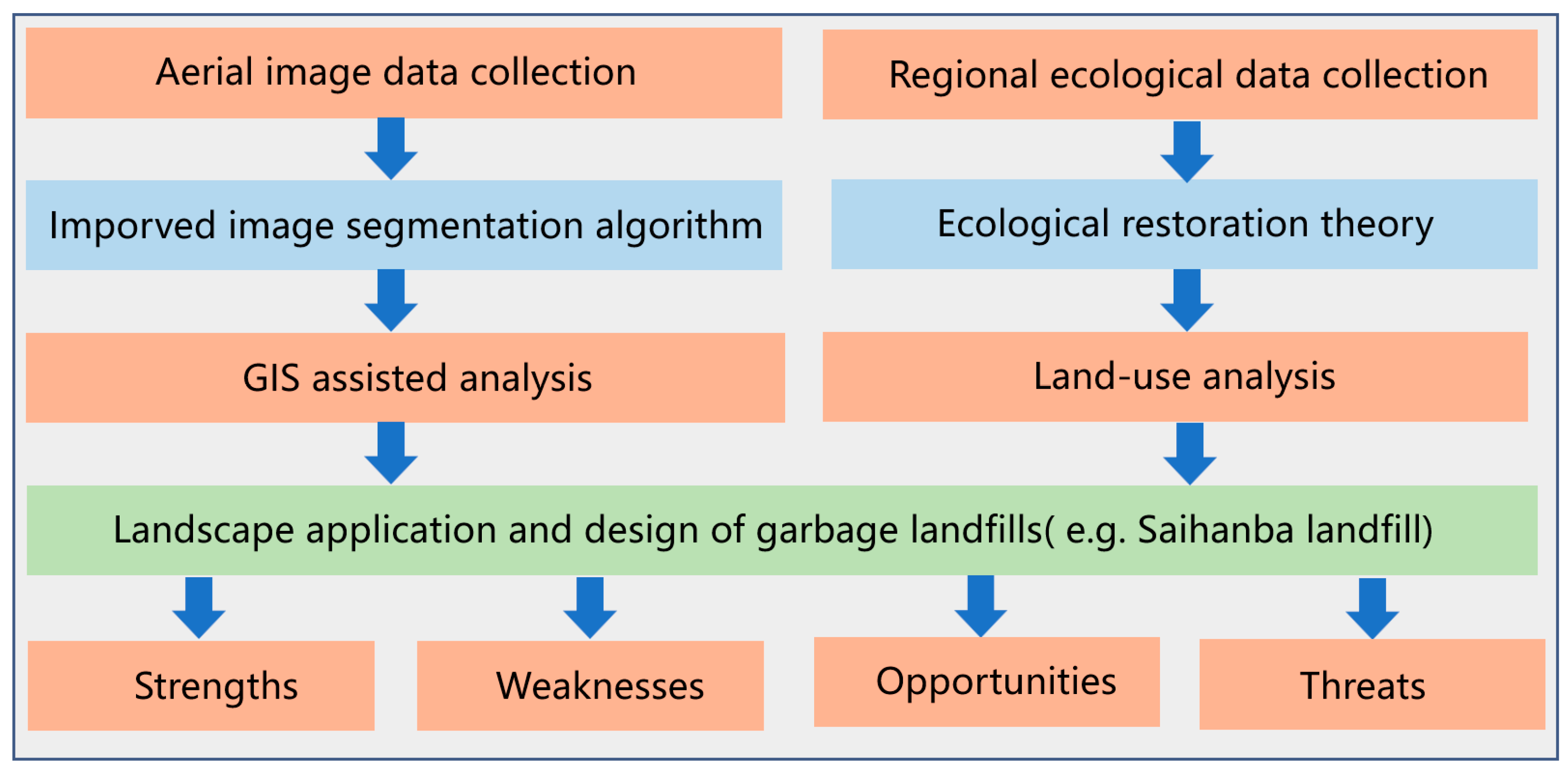
This article utilizes the Saihanba landfill site in China as a case study. Initially, aerial image data were collected, which was followed by GIS-assisted analysis and image segmentation. Then, by incorporating ecological restoration theory and conducting land-use analysis, landscape application and design of garbage landfills were explored from a landscape ecology perspective. Finally, a comprehensive planning and landscape restoration design method combining SWOT analysis from four perspectives, including strengths, weaknesses, opportunities, and threats, was proposed for the Saihanba landfill site in Hebei, China, aiming to improve the sustainable development ecological chain. The framework of this article is shown in
Figure 1.
The subsequent sections of this article proceed as follows:
Section 2 presents the background technologies;
Section 3 introduces the innovative methods proposed in this article; and
Section 4 presents the data experiments and SWOT analysis, and eventually provides a summary and explanation.
3. Methodology
Our methodology is split into two distinct phases: the training of the SEVnet2d architecture for image segmentation, and the implementation of ecological restoration theory for site assessment in garbage dump design.
3.1. Training of the SEVnet2d Segmentation Network
First, we assembled an aerial imagery dataset consisting of landfill and non-landfill areas. To optimize the data for input into the SEVnet model, preprocessing steps such as image cropping, resizing, and normalization were applied. Next, using the TensorFlow framework, we built the SEVnet network. The proposed Vnet2d architecture diagram is shown in
Figure 3. The encoder is on the left side of the VNet network and is responsible for encoding the input ultrasound image and extracting its features. It contains four encoding modules with varying feature resolutions, each comprising different numbers of convolutional and downsampling layers. Convolutional layers extract simple and complex features from ultrasound images. To enhance feature utilization, a residual connection, similar to [
29], is utilized to connect the encoder and decoder sections. Downsamplinge layers reduce the feature map size, which amplifies its receptive field and lowers computational complexity while decreasing parameter storage. Applying this downsampling operation improves image feature robustness by limiting attention to key information and ignoring redundancies. In a downsampling layer, to decrease memory consumption during training, a stride 2 convolution operation is used instead of traditional pooling.
On the right side of the network is the decoder, which is responsible for decoding the extracted feature map and restoring the resolution of the feature map. The decoder part also contains 4 decoding modules with different feature resolutions, and each decoding module consists of different numbers of convolutional layers and upsampling layers. The architecture of the convolutional layer is similar to that of the encoder part, and the residual connection is also employed; the upsampling layer uses the deconvolution operation to restore the resolution of the feature map. After each deconvolution operation of the feature map, its size is doubled, and finally, a feature map with the same resolution as the input image can be obtained. The encoder part and the decoder part are connected through 3 convolutional layers. The employed convolutional layers all have a filer of 5 × 5. And the process of the convolution can be shown as follows:
In this equation, is the bias parameter corresponding to the filter k; s is the stride and is the weight for (p,q) in the filter k. The classifier of the network consists of a 1 × 1 × 1 convolutional layer and a sigmoid activation layer, where the 1 × 1 × 1 convolutional layer is used to reduce the number of feature maps, and the sigmoid activation layer is used to calculate the final feature map. The class of each pixel outputs the segmentation probability map of the network. The skip connection combines the shallow simple features in the network with the deep abstract features to obtain more refined segmentation results.
We defined the training parameters, including the number of iterations, batch size, and learning rate. With our parameters set, we commenced the training process. The images, preprocessed for optimal performance, were input into the model. During this process, each image was passed through the model’s architecture, initializing the training phase. Upon the completion of an epoch, the model generated predicted outputs, which were essentially segmented maps. These predictions were then compared with the actual labels. Using the Dice loss function, a commonly utilized metric in image segmentation, we calculated the divergence in the model’s prediction from the true value. Next, a process called backpropagation is initiated. In this way, we determine the weights and biases that cause variance in the model and calculate the gradients that guide the optimization of the model parameters. Using the Adam optimizer, we iteratively adjusted the weights and biases, reducing the cost function.
To measure the performance of each of the proposed SEVnets and other methods, we experimented with confusion matrix and Dice loss as segmentation evaluation metrics. Both are more classic and general indicators. The specific calculation formula is as follows:
In these equations, TP is a true sample, that is, the model predicts a positive sample, and the actual one is also a positive sample. FP is a false positive sample, that is, the model predicts a positive sample, but it is actually a negative sample. FN is a false negative sample, that is, the model predicts a negative sample, but it is actually a positive sample. TN is a true negative sample, that is, the model predicts a negative sample, and it is actually a negative sample. For urban aerial image segmentation with the purpose of garbage dump recognition, positive and negative samples represent the pixels of the garbage dump area and non-garbage dump area. According to the definition, Dice can be approximated as the consistency coefficient between the garbage dump area segmented by the model and the actual garbage dump area. Accuracy (ACC) can represent the proportion of correctly classified pixels in the aerial image, Precision (Pre) represents the probability of the garbage dump being correctly segmented, Recall (Re) represents the probability of the actual garbage dump area being correctly segmented, and Specificity (Spe) represents the probability of the actual non-garbage dump area being accurately segmented. Due to the importance placed on the accuracy of garbage site segmentation in this article, Dice and ACC are the most important indicators. When the difference between the two is not significant, other indicators will be considered.
Table 1 shows the performance comparison of the performance indicators of the segmentation methods based on the ETVnet, Unet, Unet++, and Attention Unet models on the same dataset described above. In the case of a certain amount of data, the indicators of ETVnet are significantly optimized compared to other models. In fact, in the segmentation results of UNet, UNet++, and Attention UNet, the segmentation edges are not precise enough, and there are many over-segmentation phenomena. Some areas farther from the contour marked by experts will be classified into the predicted results. At the same time, U-Net++ shows some undersegmentation in the small area garbage dump. The edge contour of the segmentation results of this method is retained in the vicinity of the expert mark, and there is no significant error in aspect ratio and shape. The segmentation effect is more refined, which is closer to the ground reality.
3.2. Design of Garbage Dump Based on Ecological Restoration Theory
Effective management of urban garbage landfills involves comprehensive land use planning and factors such as economic, social, and ecological considerations. We use an integrated assessment approach that synergizes our understanding of the impact of natural factors and human activities on the potential functionality and recoverability of landfills. The integrated assessment approach includes two dimensions: natural impacts and human impacts, as shown in
Table 2. Each dimension contains a number of specific indicators that help provide a comprehensive assessment of potential landfills. The Natural Impact Index focuses primarily on the characteristics of the natural environment surrounding potential landfills. Using detailed analysis of GIS, we studied elements such as topography (extracted by DEM), slope properties, dominant wind direction (using Hebei meteorological data), and vegetation cover (calculated from the dimidiate pixel model). To understand the influence of human activities, our attention was focused on land use types, existing transport systems, and the distribution of facilities like plants, scenic spots, and residential areas. The OpenStreetMap vector data provided essential support for assessing traffic levels, with distance classifications included.
To ensure the validity of our evaluation, we employed the analytical hierarchy process (AHP), a renowned decision-making method for complex, multi-criteria problem-solving. By determining the weight of each evaluation indicator, we were able to guide the planning process by giving precedence to indicators of vital importance. By employing cluster analysis on metrics derived from evaluation indicators, we segmented regions into hierarchical levels of suitability for landfill development. Each class of suitability had its inherent characteristics that informed the design allocated to that region. The culmination of our evaluation resulted in the strategic design of functional partitions in the dump area. Our design diverged from traditional landfill structures by dividing the landfill site into four functional regions—a garbage collection and distribution area, a garbage art area, an experimental field research area, and an ecological restoration area. The functional content of each functional area is shown in
Table 3.
Urban household waste in China has the basic characteristics of mixed components, high moisture content, and low calorific value. However, due to the lack of sorting, the composition is extremely complex, with a moisture content of over 50% and an average calorific value of only 3300–4200 KJ/kg, with significant differences depending on region, season, and living standards. The feasibility of this design was tested against varied scenarios drawn from the composition and elemental content of urban garbage, using the region of Hebei as our case study. The composition of garbage is shown in
Table 4, and the elemental analysis is shown in
Table 5. This also provides a reference basis for our subsequent experimental design.
4. Design Practice of Saihanba Garbage Dump in China
4.1. Sustainable Development Division of Saihanba Region Based on Aerial Data Segmentation and Ecological Restoration Theory
Saihanba, one of the largest artificial forest areas in China, is considered a green miracle in northern China because of its fascinating history and mystery. Located in Chengde City, Hebei Province, it is vital to plan suitable urban household waste landfills in Saihanba to address the problem of garbage accumulation in Hebei. This planning is also important for generating biogas resources from garbage and providing electricity to surrounding residents, contributing to the area’s sustainable development. If planned properly, Saihanba can accommodate 25% of Hebei’s household waste and generate sufficient electricity for 200,000 residents. Therefore, designing urban garbage sites in Saihanba is crucial for promoting sustainable development in the area.
This article uses the Saihanba area in Hebei Province as an example to present a detailed sustainable design method for urban garbage dumps based on the method proposed in this study, with research data sources shown in
Table 6. Using an aerial data segmentation method proposed in this study, the specific locations of potential urban garbage dumps are determined, and the boundaries are accurately segmented, as shown in
Figure 4. Accurately identifying dump areas lays the foundation for the ecological restoration analysis in subsequent steps.
Next, through the application of ecological restoration theory and GIS multilevel perception, the Saihanba landfill area’s functional areas were designated. GIS’s spatial analysis function allows for comprehensive, intuitive, and multifaceted data analysis, enriching urban planning methodologies and providing a scientific foundation for urban ecological planning. Planning suitability analysis, conducted using the superposition analysis method, divides the entire Saihanba landfill area into functional areas and provides useful insights for landscape design. To determine each functional area’s planning suitability, a survey of land and social resources is performed to identify the appropriate influencing factors. After determining the specific location, data are collected on specified factors and assessed using an analytic hierarchy process to determine the weights of the evaluation indicators. Based on the weights of the evaluation indicators, analysis is carried out to determine the planning suitability of each functional area. Finally, the suitability analysis results for each functional area are categorized into one of four levels: suitable, more suitable, under investigation, or unsuitable.
Figure 5 displays the functional area planning suitability results.
A comprehensive zoning assessment of the Saihanba landfill site was conducted and its outcomes are presented in
Figure 6. The ecological rehabilitation zone prevails in the southeast of the landfill and has undergone successful restoration, with optimal vegetation coverage. By contrast, the garbage collection and distribution area and the garbage art zone are situated in the northern and southern portions of the central research area, respectively, utilizing bare land as the predominant land-use type in this region. The experimental site research area is primarily located in the southern section of the research area and neighbors the leachate treatment plant. The area designated for assessment overlaps two or more functional areas with similar resilience, and thus actual circumstances must decide the final planning outcome.
4.2. SWOT Analysis of the Ecological Restoration of Saihanba in Hebei
The SWOT method was employed to assess the regional development opportunities, threats, advantages, and disadvantages of the Saihanba landfill site’s design. The survey data were systematically recorded and analyzed using the comprehensive system analysis concept, comparing various factors to obtain the conditions for effective ecological restoration in Saihanba, Hebei, facing the particular environment of the Saihanba forest farm. This involved conducting a comprehensive, systematic, and rigorous study to develop corresponding development strategies and plans based on the findings of the analysis [
30,
31].
- (1)
Strength
The Erfoshan region where the Saihanba landfill is located has a developed and comprehensive framework for urbanization and landscape development. It is currently in a rapid development stage, with parks such as the National Biomedical Park and Fozuling Industrial Park, quality communities like Jiayuan Huadu, and universities that include the Huazhong University of Science and Technology. Furthermore, scenic spots such as Donghu Lake provide ecological resources that support and contribute to the transformation and development of Erfoshan.
- (2)
Weaknesses
The existing infrastructure construction at the Saihanba landfill site needs improvement and is not perfect. In the face of leachate leakage and biogas problems, the treatment is not prompt enough. In addition, ecological construction and landscape design were not well integrated, and the surface soil cover problem was handled very simply. The vegetation establishment and ecological restoration process will take time, and the natural climate is also a significant drawback of the Saihanba forest. The high temperature in the summer generates a sizable amount of gas and odor from garbage, which has an impact on the surrounding areas. Abundant rainfall causes the topsoil in the waste dump to slide, exposing protective membranes and, as a result, leading to leachate leakage.
- (3)
Opportunities
The Saihanba landfill site has plans to build China’s first large indoor skiing park, which has broad development prospects. The economic benefits that the park will bring will hopefully drive the development of ecological civilization in the Saihanba forest farm. Ecological management in the Optics Valley Industrial Park of the Saihanba forest farm will carry out corresponding renovations to the internal environment of the Saihanba Tea Garden to restore the topsoil, rebuild vegetation and terrain, increase leisure facilities, strengthen management, better protect the wasteland, and achieve ecological self-restoration functions.
- (4)
Threats
The Saihanba dump is adjacent to the newly built Hubei Olympic Sports Center. According to the plan, there will be an Olympic International Expo Center within 3000 acres of land and the ecological restoration of the Saihanba garbage dump in the area has become a challenge in the planning. The southern terrain is low-lying, extending all the way to the villagers’ farmland. Once the leachate leaks, it will result in immeasurable pollution. In addition, due to the fact that the landfill site is located at the upper air outlet of the environmental space, the gas generated by the accumulation of garbage will be transported to the air downstream of urban living with the wind direction, which also poses certain risks to local residents.
4.3. Natural Landscape Design of Saihanba in Hebei
Soil, groundwater, and air samples from Saihanba in Hebei were collected and subjected to analysis. Various indexes, including the single-factor pollution index, geoaccumulation index, and potential ecological hazard index, were evaluated to determine the environmental impact of the landfill site. The findings indicated that the site had minimal impact on the surrounding air, groundwater, and soil. The concentrations of compounds such as ammonia, hydrogen sulfide, and methyl mercaptan were all lower than the secondary standard prescribed in the GB 14554-93 emission standards [
2]. Similarly, the concentrations of Cu, Pb, CD, Cr, Hg, and As in groundwater were within safe limits, while those present in the soil were lower than the risk screening value (pH > 7.5) articulated in GB 15618-2018 [
4], the Soil Environmental Quality Standard for Agricultural Land Soil Pollution Risk Control Standard (Trial).
Table 7 shows the design basis and objectives.
- (1)
Design basis and objectives
Every ecological factor investigated plays an important role in the interaction with and restriction of other factors. A change in any factor will cause a change in other factors in varying degrees, which is the comprehensive effect between factors.
Table 8 shows a survey of the impact factors formed by the geomorphological factors, eco-meteorological factors, and social factors of the Saihanba tree farm.
- (2)
Concerns and design philosophy
Through the utilization of ecological restoration methods, an urban leisure space is planned to improve the aerobic environment and enhance the quality of life for urban residents while fulfilling their leisure needs. Additionally, the project aims to explore the history of Erfoshan Mountain; excavate cultural heritage; establish a public leisure space; create a site that fosters contemporary art; and build, display, and deliver a unique ecological civilization specific to the region.
In consideration of three key issues discovered during the field survey—new methods for garbage disposal, potential opportunities for a garbage disposal yard, and the challenges facing the existing waste disposal facility—this paper presents original viewpoints and recommendations for the future design of the landfill facility in Erfoshan. To design an appropriate ecological restoration layout for a closed landfill, consideration must be given to the terrain height, in addition to strict adherence to the treatment technology and requirements through a well-developed design plan. Throughout this process, it is essential to preserve the overall accumulation form of the landfill, which cannot be adjusted vertically [
32].
During the ecological recovery of the landfill, it is crucial to selectively plant species to improve survival rates, prioritizing local flora. Once the biological community reaches the desired stage, artificial interventions can promote the combination of compatible organisms to create a landscape suitable for human leisure while effectively restoring the ecological environment and following the natural laws of sustainable development.
- (3)
Age and plant growth cycle analysis
In the landscape design planning of the Saihanba tree farm, it is important to consider the needs of people of all ages. To accommodate the unique characteristics of each age group, various landscape points should be designed. For infants, adult companionship is essential, while children’s climbing and walking devices within a safe, slow-living space can be provided. Imitating adult activities such as playing with water, sand-piling, and jumping can be facilitated through interactive play devices. Preschool students tend to enjoy vigorous exercise and slightly complex games with interactive features. School-age children prefer cooperative activities, teamwork, and purposeful learning opportunities and may benefit from having access to a learning museum. Adolescents, full of vitality and positivity, crave challenges and may require some spaces catering to those in the early stages of adulthood. As such, it is essential to incorporate space for adult leisure and rest.
Vegetation community restoration is a critical stage in the restoration process and must be approached with much care and consideration. When selecting plants for collocation, preference should be given to local species that can lead to increased plant survival rates. Additionally, plant species that can improve soil quality, without damaging the isolation layer through their root system, should be given priority. This selection should start with shallow-rooted plants and progress to taller trees over several years. Plants that can be planted for one year in a landfill include clover, Zhifeng grass, cowgluten grass, or thrushi grass, while plants that can be planted for two to three years after a landfill include purple locust, wolf-berry, and corydom. Trees that can be planted for more than three years in a landfill include white wax trees, Acacia Acacia, bitter advice, and other types. Once the landfill environment becomes stable, different plants can be considered to create beautiful scenery, protect the growth space of future design plants, and be matched with flowers and green plants.
- (4)
Design of the general layout and other functional analysis
In this paper, the Saihanba landfill site is divided into six main landscape nodes, as depicted in
Figure 7, which portrays Fendai Park. In the later stage of restoration, a substantial number of Fendai flowers are planted to adorn the park and augment its aesthetic. This promotes increased tourist activity and boosts economic development in the surrounding area (1). Second, the site functions as a research center for waste filtration, encouraging further understanding of ecological restoration and waste management through a publicly accessible “Museum” (2). Third, this area serves as a rhythm leisure park that incorporates cultural history, infusing cultural heritage with contemporary designs that feature interactive amusement settings, catering to school-aged children’s recreational needs (3). Fourth, the experimental restoration park features substantial technical support, serving as a “pioneer” in ecological restoration, and laying the groundwork for future restoration in the landfills (4). The experimental observation field (5) features leachate treatment and waste gas collection devices necessary for restoration, and the trail area features ample shade, leisure space, and a sports trail catering to adult activities (6).
The entire environmental space is segmented into four zones, as depicted in
Figure 8: the green zone serves as the collection and distribution area for garbage, the red zone functions as the garbage art area, the yellow zone is reserved for experimental field research, and the blue zone is dedicated to ecological restoration. These four areas mutually support and integrate with each other to form an organic whole, with the goal of achieving balance through natural means. In the landscape design of the Saihanba area, the author drew upon ecological principles, experience in landscape design, and user needs to reasonably plan the direction of streamlines, with the red road acting as the main landscape walking path, the blue road as a secondary route, and the green route serving as a cross-path, offering a well-rounded and multi-faceted user experience within the park.
5. Conclusions
In this study, an innovative technical route is adopted to design an urban solid waste landfill by combining deep learning segmentation of aerial images with ecological restoration theory. Through a self-developed enhanced SEVnet deep learning model, high-precision automatic landfill identification is realized, which provides an accurate basis for functional zoning design. In the case study, ecological restoration theory is used to evaluate the natural environment and socio-economic factors around the landfill, and reasonable functional zoning schemes such as an ecological restoration area, a garbage disposal area, and an experimental observation area are proposed. The results show that deep learning technology can accurately and automatically identify the scope of landfills, that ecological restoration theory can scientifically guide the design of functional zoning, and that the organic combination of the two can greatly improve the planning and design quality of landfills. The innovation of this study lies in the combination of deep learning technology and design theory, which provides new ideas for landfill planning and design and has important scientific value and application prospects.
Real-time monitoring of a landfill environment has been made possible through the application of AI-driven image segmentation. This new capacity allows us to accurately delimit the scope of a landfill, providing preventive measures to mitigate the risk of secondary pollution in key ecological areas and water regions. By enabling a closer, more precise monitoring of landfill sites, we empower organizations to proactively manage and minimize environmental risks, safeguarding critical ecological areas.
Ecological restoration theory is combined with physical, chemical, and other technical methods for comprehensive research from the surface soil upwards, resulting in a space that satisfies the demands of contemporary sustainable development. As demonstrated in this article, ecological design involves a collaborative process between humans and nature, with landscape design open for public and communal consultation, effectively removing landfill sites from being seen as grey areas to be avoided. This article incorporates ecological restoration into the overall design, with an emphasis on clarifying the objective of restoration work, upholding restoration principles, and returning to nature. This essence of nature–human growth serves as a foundation for new solutions in sustainable development.
In addition, the strategic zoning and design of different functional areas play an integral role in promoting sustainable development. Within the confines of these areas, the field of ecological restoration not only revitalizes the adjacent ecological environment but also provides space for public interaction and leisure. At the same time, the waste treatment area optimizes the use of resources and promotes economic benefits. In addition, the experimental observation sector is a crucible of knowledge, accumulating valuable insights and expertise that will lay the groundwork for subsequent informed landfill restoration efforts. Ultimately, through intelligent functional segmentation, the land within the landfill is used wisely, ensuring the most efficient and sustainable use of available resources.


