Article

A Comprehensive Evaluation and Analysis of Ground Surface Damage Due to Mining under Villages Based on GIS

1
College of Energy Engineering, Xi’an University of Science and Technology, Xi’an 710054, China
2
State Key Laboratory of Coal Resources in Western China, Xi’an University of Science and Technology, Xi’an 710054, China
3
College of Energy and Mining, China University of Mining and Technology (Beijing), Beijing 100083, China
4
Yulin City Energy Bureau, Yulin 719300, China
*
Authors to whom correspondence should be addressed.
Appl. Sci. 2023, 13(18), 10136; https://doi.org/10.3390/app131810136
Submission received: 4 August 2023 / Revised: 22 August 2023 / Accepted: 7 September 2023 / Published: 8 September 2023

Abstract

:
This paper aims to evaluate the severities and causes of ground surface building and cropland damages after coal mining in a better way, and to clarify the correlation between the damage assessment indexes that influence mining. Against the backdrop of multi-seam mining in certain coal mines in China, the estimated results of each displacement and deformation were analyzed using GIS technology. The damage range determined for each deformation index is divided according to the displacement and deformation combined with the virtue of damage judgment threshold. The damage ranges on the ground surface based on the comprehensive value of each displacement and deformation index were obtained through superimposing those ranges delineated by each displacement and deformation index, and the law on influence from displacement indexes upon various levels of damage was analyzed in a quantitative manner accordingly. The results showed that coal mining destroyed 14 buildings and a cropland area of 11.96 hm2; among them, building damage was only associated with displacement indexes E (horizontal deformation) and T (inclined deformation). Seven buildings were solely destroyed by T alone; five buildings were solely damaged by E; two buildings were damaged jointly by E and T; and, moreover, with the aggravation in building damage level, the proportion of building damage due to E decreased while the proportion of building damage under the same level due to T increased. Regarding cropland destruction, the damage due to T accounted for 33.48% while the damage jointly caused by W (Subsidence), E and T accounted for 30.45%. Moreover, the proportion of damaged cropland area due to inclined deformation T was positively correlated with cropland damage level. These findings can provide a reference for rational judgment regarding civilian building and cropland destruction on the ground surface after coal mining.

1. Introduction

With the exploitation of coal resources, the problem of coal deposits under buildings, railways and water bodies, namely “three-under coal deposit issue”, has now arisen in most mining areas [1,2,3]. The cropland and building safety in mining area is subject to topography, geomorphology, groundwater level change and other factors. However, regarding the coal-mining-impacted area, the mining-induced surface displacement and deformation mainly account for buildings and cropland damages [4,5]. In particular, the proportion of coal deposits under villages is prominent [6,7,8]. The surface displacement triggered by underground coal mining will not only damage village buildings [9], environments [10], croplands, etc. (as shown in Figure 1), but will also incur enormous compensation against coal enterprises. Therefore, a precise and accurate assessment of the damage level of surface buildings and croplands due to coal mining becomes one of those crucial problems faced by “three-under coal deposit” mining.
Underground mining impacts surface buildings in multiple respects [11,12]. Many experts and scholars have carried out in-depth research assessing the coal-mining-induced damages to building and land resources. Liu, X. [13], Trzałkowski, P. [14], López Gayarre, F. [15] and Can et al. [16] analyzed the building failure mechanism through observing the building deformation and damage distribution in coal mining subsidence areas, in combination with numerical simulations and other measures, and then concluded the law on the influence from different displacement indexes upon the structural stability of buildings. According to the analysis by Cui [17] on building damage judgment methods, building classification and computer-aided analysis can facilitate in improving the accuracy of coal-mining-induced damage assessment. Andrzej Kwinta [18] judged building damages based on the relationship between the coal mining work face boundary and the building protection boundary through calculating the building protection radius under different geological conditions. Concerning cropland damage, Chen, Y. [19] investigated croplands in coal mining subsidence areas in Shandong Province, China, analyzed the status quo, and the trend of cropland damage due to coal mining, and revealed the impacts from cropland damage upon the ecological environment and social stability. Zhang, Y [20] researched the law on the influence of coal mining on soil nutrients through numerical simulation and evaluated the possibility of land reclamation under different schemes. Zhao [21] and Jin [22] constructed an assessment index system to forecast the coal mining-induced cropland damage and destruction level, and then proposed a compensation scheme based on damage level.
Although China has established clear and uniform assessment criteria for both building and cropland damages in coal mining areas, experts and scholars try to introduce GIS technology into the mining damage assessment field [23,24,25] due to many factors concerning judgment criteria and the cumbersome damage level judgment procedure. Nadudvari et al. [26] observed the laws on surface subsidence since the initial mining in the Upper Silesia Coal Mine 20 years ago using radar interferometry technology. The map on damage risks in the subsidence area can effectively establish the correlation between underground mining faces and surface buildings [27]. Akcin [28] established a GIS risk assessment model to classify the surface building damage areas due to underground coal mining so as to assess the risks in surface building. Based on the results from the displacement and deformation of the ground surface, Zhang [29] designed a visualization system for coal-mining-induced damages to surface buildings by virtue of VB language and in light of GIS, thus achieving a rapid judgment on building damage level. Based on the Arc GIS platform, Huang [30] achieved the visual assessment of building and road damage in mining areas, and proposed the corresponding remediation and protection measures.
Although scholars have improved the assessment efficiency concerning ground surface damages due to work face mining by virtue of GIS, most of their research focuses on the assessment results concerning housing and land damages, while there has been few analyses of damage causes. Therefore, based on the ground surface displacement and deformation forecast, the damage ranges delineated by each displacement and deformation index were superposed by virtue of the Arc GIS 10.4 software in this paper, so as to obtain both the ground surface range and cropland damage range that synthesize each displacement and deformation. The damage causes of each point were analyzed and a distribution map on damage causes was drafted; then, the damage causes for civilian buildings and croplands on the ground surface were assessed and analyzed. On this basis, against the backdrop of coal mining under a village in certain coal mines in China, the ground surface range and the cropland damage after coal mining were forecast and analyzed.

2. Comprehensive Ground Surface Damage Forecast Method

2.1. Displacement and Deformation Forecast

Currently, the probability integration method (PIM) is widely adopted to forecast the ground surface displacement and deformation due to underground mining [31]. According to its principle, the rock mass overlying the coal seam is taken as a loose discontinuous medium; the mining process is divided into multiple infinitesimals; the overlying rock mass subsidence triggered by each infinitesimal mining process is taken as one random event; and the influences from all infinitesimals upon the displacement and deformation on the ground surface are superposed as the displacement and deformation due to coal mining [32]. By now, the probability integration method has been incorporated in the Code for Coal Pillar Retention and Coal Mining under Buildings, Water Bodies and Railways and in Main Shafts and Lanes [33] for coal mining guidance in China. Therefore, the mining damage assessment system [34], based on the probability integration principle, was adopted here to forecast the displacement and deformation of ground surface.
As shown in Figure 2, s o t is the coal seam coordinate system where s direction is parallel to work face strike, t direction is parallel to work face dip, and   x o y   is the projection of the coal seam coordinate system on the horizontal plane. If the i th infinitesimal A is mined in the coal seam, the values of both subsidence and horizontal displacement at the point A (x1, y1) on the ground surface triggered by infinitesimal A will be shown as Equations (1) and (2) [35,36]:
W ( x 1 , y 1 ) = i = 1 n W max W e ( x 1 , y 1 ) d s d t = i = 1 n W max r 2 e π ( x 1 s ) 2 + ( y 1 t ) 2 r 2 d s d t
U ( x 1 , y 1 , φ ) = i = 1 n 2 π b W max r 2 ( x 1 s ) cos φ + ( y 1 t ) sin φ e π ( x 1 s ) 2 + ( y 1 t ) 2 r 2 d s d t
where W x 1 , y 1 refers to the quantity of subsidence triggered by underground coal mining at point A x 1 , y 1 on the ground surface; U x 1 , y 1 , φ refers to the quantity of horizontal displacement triggered by coal mining at point A x 1 , y 1 on the ground surface; φ is the horizontal displacement direction angle of point A on the ground surface; W max   refers to the maximum value of ground surface subsidence whose calculation method is W max = m η cos α ; m is the mining thickness on the work face; η is the subsidence coefficient; α is the coal seam dip angle; r is the major influence radius whose calculation method is r = H / tan β ; H is the coal seam bury depth; and   tan β is the tangent value of major influence angle.

2.2. Forecast and Assessment Indexes

2.2.1. Coal-Mining-Induced Building Damage Assessment Indexes

An accurate, comprehensive and rational assessment factor and index system serves as the key for a reasonable assessment of coal-mining-induced civilian building and cropland damages [37]. The main causes for building and cropland damages in the mining area are displacement and deformation triggered by coal mining. The displacement and deformation of ground surface comprise the subsidence, inclined deformation and curvature deformation in the vertical direction, and the displacement, stretching and deformation in the horizontal direction. Among them, building damage is mainly subject to the inclined deformation, horizontal deformation and curvature deformation of the ground surface [38]; cropland damage is mainly subject to the subsidence, horizontal deformation and inclined deformation of the ground surface. The relationship between each displacement and deformation index is as follows:
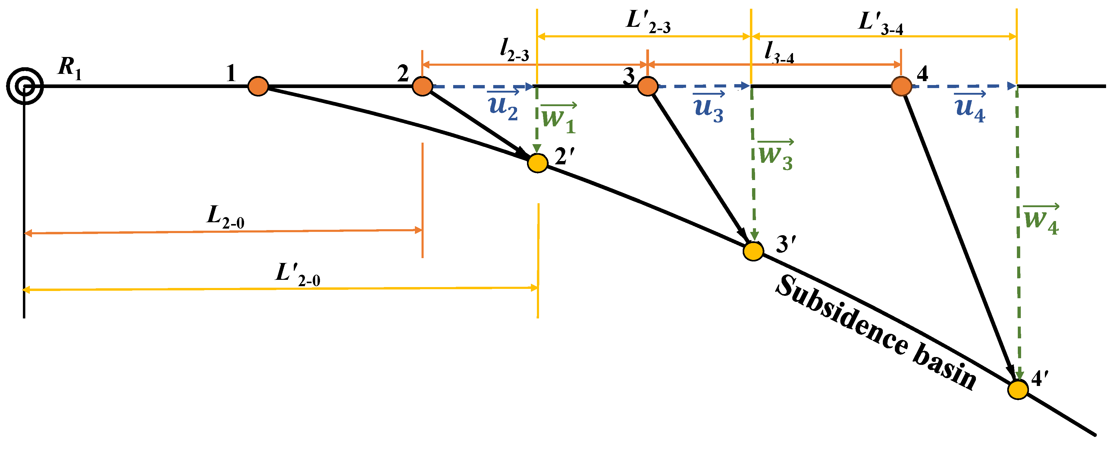
As shown in Figure 3, points 2, 3 and 4 are points on the ground surface before coal mining, while points 2′, 3′ and 4′ are the corresponding points on the ground surface after surface deformation due to coal mining. The displacement and deformation of ground surface can be characterized through researching position changes in those points on the ground surface before and after coal mining. The horizontal displacement quantities of points 2, 3 and 4 are recorded as u 2 , u 3 and u 4 , respectively, and their subsidence quantities are recorded as w 2 , w 3 and w 4 . Then, the inclined deformation i 2 3 , mm/m, from point 2 to point 3 on the ground surface, the curvature deformation k 3 , 10−3/m of point 3 and the horizontal deformation value ε 2 3 , 10−3/m from point 2 to point 3 are calculated using the following Equations (3)–(5):
i 2 3 = w 3 w 2 l 2 3
k 3 = i 3 4 i 2 3 1 2 ( l 3 4 + l 2 3 )
ε 2 3 = u 3 u 2 l 2 3
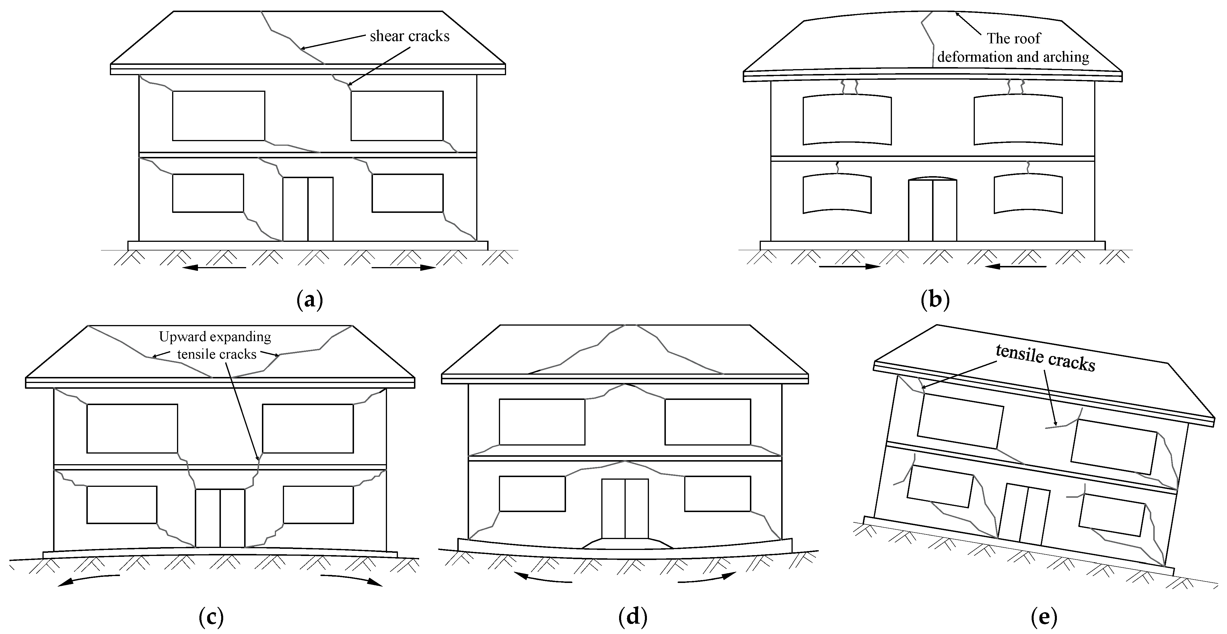
The coal-mining-induced inclined deformation, curvature deformation and horizontal deformation of the ground surface have great influences upon the structural stability of buildings. Building damage characteristics vary depending on causative displacements. (1) The influence of horizontal deformation upon buildings; buildings present a weak tensile strength so tensile deformation will affect their walls and result in tensile cracks (as shown in Figure 4a), while compressive deformation will arch the ground surface and roof up and warp windows and door frames (as shown in Figure 4b). (2) The influence of curvature deformation upon buildings; the positive curvature generated on the ground surface will sink both sides of a wall and stretch the upper wall to form inverted “ -shaped” cracks (as shown in Figure 4c), while the negative curvature will sink the middle part of a wall and stretch the lower wall part to form “ -shaped” cracks (as shown in Figure 4d). (3) The influence of inclined deformation upon buildings; the inclined deformation of the ground surface and the movement in the center of gravity of a building form additional torque, break the original equilibrium state and generate a horizontal shear force that destroys a building (as shown in Figure 4e).
According to the classification standard for building damages in coal mining areas in the Code for Coal Pillar Retention and Coal Mining under Buildings, Water Bodies and Railways and in Main Shafts and Lanes, the buildings in the coal-mining-influenced area were classified into four damage levels, as shown in Table 1.

2.2.2. Coal-Mining-Induced Cropland Damage Assessment Indexes

The uneven ground surface subsidence after coal mining results in cracks in the ground surface, then lowers the groundwater table and deprives the soil of moisture and nutrients. Inclined deformation changes the cropland slope and, thus, increases the difficulty of cultivation [39,40]. According to the relevant provisions of the Ministry of Land and Resources of the People’s Republic of China [41], the subsidence, inclined deformation and horizontal deformation of the ground surface were selected as the assessment indexes for cropland damage level and classified into three damage levels based on Table 2.

2.3. Comprehensive Damage Area Division

When it comes to the rural building and cropland damage and destruction level forecast, we first need to extract the displacement and deformation quantities of the research object, and then compare them with the corresponding damage threshold of each deformation index so as to determine the damage level. There are a large number of buildings, random building locations and other problems during the ground surface building damage forecast in the mining area using traditional methods. As for the cropland damage forecast, there are inaccurate damage level forecasts and other problems in view of the planar cropland distribution and its irregular boundary.
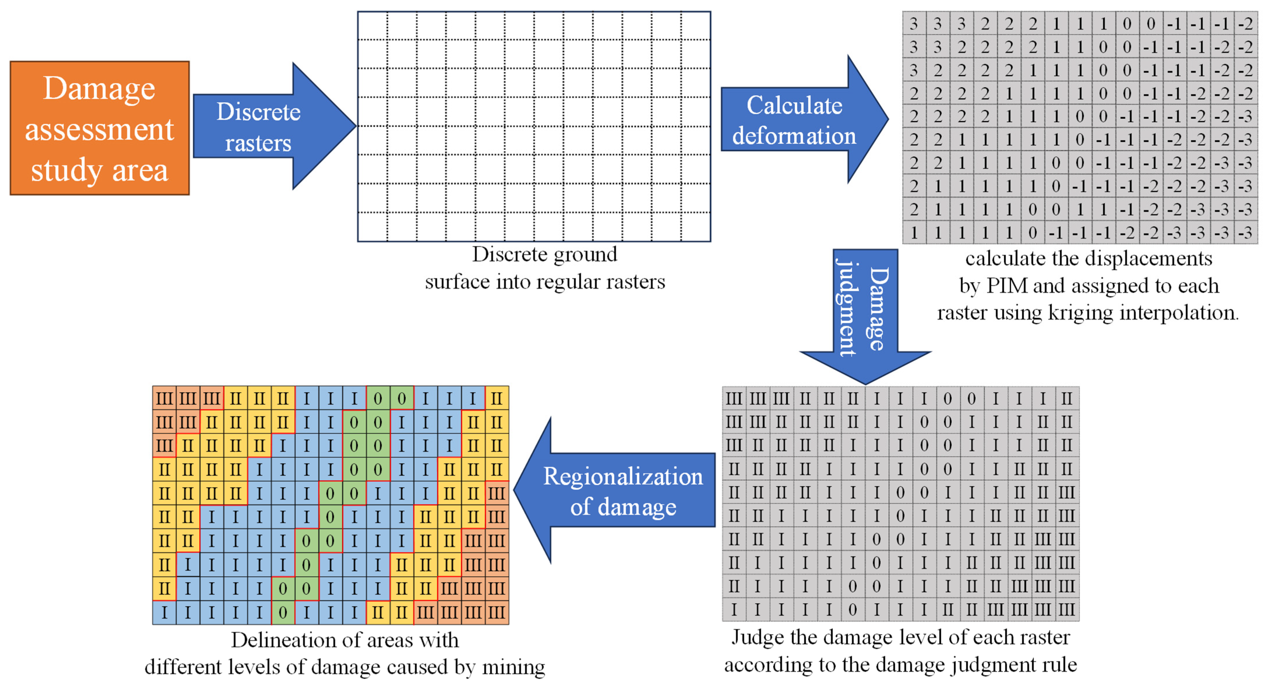
The aforementioned problems can be resolved in a better way through the damage-overridden area division in the mining area. Regarding the damage-overridden area division by virtue of Arc GIS, we first need to discretize the ground surface into regular raster, and then assign the displacement and deformation at each point on the ground surface triggered by coal mining to each raster using the Kriging method. According to the assessment standards of building and cropland damage severities, the damage severities of each raster caused by different displacement indexes are analyzed so as to divide the damage-overridden range determined by each deformation index in the targeted area. The specific division process is shown in Figure 5.
The damage levels of buildings and croplands on the ground surface are subject to joint influences from multiple displacement indexes. When it comes to the assessment of the same target in the mining-influenced area, the damage judgment thresholds of each deformation index are different, thus resulting in differences in damage levels from the judgment. Therefore, the ultimate building and cropland damage levels in this point should be assigned with the highest values according to the damage levels judged by each deformation index. Based on this judgment rule, we can obtain a map of damage ranges caused by multiple deformation indexes on the ground surface in the targeted area. We can produce a map of damage ranges caused by the multiple deformation indexes integrated on the ground surface in the targeted area. This can be achieved by superimposing multiple damage range maps produced by single deformation indexes by virtue of GIS (The principle is shown in the Figure 6).
Through the comparison of the comprehensive damaged area division results with the building and cropland locations on the ground surface, the building and cropland damage forecast in the coal-mining-influenced area can be realized in a quick, accurate and visualized manner. The locations of low damage levels can provide guidance and serve as the sites for building relocation and new buildings.

3. Analysis of Influencing Factors of Ground Surface Damages

3.1. Damage Cause Distribution

The comprehensive damage level at each point on the ground surface is the maximum value among the single assessment results using multiple displacement indexes. Therefore, the deformation index whose damage level reaches the comprehensive damage level at this point among the single displacement indexes is taken as the damage cause at this point. To carry out damage cause analysis, we first need to import the level distribution map of the damages due to single deformation indexes, and the comprehensive level distribution map of the damages, and then extract each raster for analysis. The ground surface raster α is assumed to be the damages caused by the displacement indexes i ,   j and k ; the corresponding single deformation index damage levels are N i ,   N j and N k and the comprehensive damage level is N ; in this case, the damage cause for raster α is determined as shown in Equation (6). By virtue of the raster calculator function of software Arc GIS 10.2, the raster is analyzed according to Equation (6), so as to draw the distribution map of damage causes.
Damage   Reason i - Single   cause : ( N i = N ) ( N j < N ) ( N k < N ) j - Single   cause : ( N i < N ) ( N j = N ) ( N k < N ) k - Single   cause : ( N i < N ) ( N j < N ) ( N k = N ) i ,   j - Joint   cause : ( N i = N ) ( N j = N ) ( N k < N ) j ,   k - Joint   cause : ( N i < N ) ( N j = N ) ( N k = N ) i ,   k - Joint   cause : ( N i = N ) ( N j < N ) ( N k = N ) α ,   β ,   γ - Joint   cause : ( N i = N ) ( N j = N ) ( N k = N )

3.2. Quantitative Analysis of Damage Causes of Each Damage Level

The above analysis concludes the contribution from a single deformation index to overall damage. In order to further quantify the law of influence from displacement indexes upon different damage levels, the contribution rate analysis method was designed to quantitatively assess the influence from each deformation index upon each damage level.
The specific process goes as follows:
The basic calculation method for contribution rate [42] is shown in Equation (7):
R i = t i T i
where R i is the contribution rate of deformation index   i   ; t i is the increment caused by indexes   i in the overall damage; and T i is the overall damage in the targeted area.
The contribution rate of deformation index i to the area with a damage level at N within the targeted area was calculated as follows:
(1)
The map of the damage ranges caused by multiple deformation indexes integrated on the ground surface was imported, and all rasters with their damage level at N in the targeted area were extracted. It was assumed that there were H rasters in total, and those rasters were numbered 1 ,   2 ,   3 α H .
(2)
If the damage level assessment factors of raster α were displacement indexes i ,   j and k , and the corresponding damage assessment results of raster α were n α i , n α j and n α k , respectively, the comprehensive level of raster α was N α = max   n α i   ,   n α j ,   n α k   = N , according to the ground surface damage assessment rules. If the single assessment grade of deformation index i to raster α was n α i   < N α , the deformation index i had no influence upon the damage level N α of raster α . If n α i   = N α , the contribution of i to the comprehensive damage assessment result N α was 1. Parameters m α i , m α j and m α k were adopted to characterize whether displacement indexes i ,   j and k contributed to the comprehensive damage level of raster α , and then m α i could be calculated using Equation (8):
m a i = 0 : n α i < N α 1 : n α i = N α
(3)
Therefore, the number of displacement indexes contributing to the deterioration of the raster α up to the damage level at N were exactly M α = M α i + M α j + M α k . It was assumed that when the damage level was N α , the corresponding building or cropland damage degree was β (this is a relative value that quantifies the relative damage consequences of each damage level upon buildings and croplands on the ground surface), and the deformation index i contributed to the raster α ’s final damage level, namely   m α i = 1; then, the increment calculation method for coal-mining-induced damage due to factor i is shown in Equation (9).
t α i = β M α
(4)
Among those extracted H rasters of a damage level at N , the coal-mining-induced damage increment due to factor i is shown in Equation (10):
t i = α = 1 H β M α = β α = 1 H 1 M α
The total coal-mining-induced damage increments in those rasters of a damage level at N in the area are shown in Equation (11):
n i = α = 1 H β = H × β
Therefore, in combination with Equations (7), (10) and (11), the contribution rate of the deformation index i to the damage level of N in the assessment area is shown in Equation (12):
R N i = t i n i = β α = 1 H 1 M α H × β = α = 1 H 1 M α H
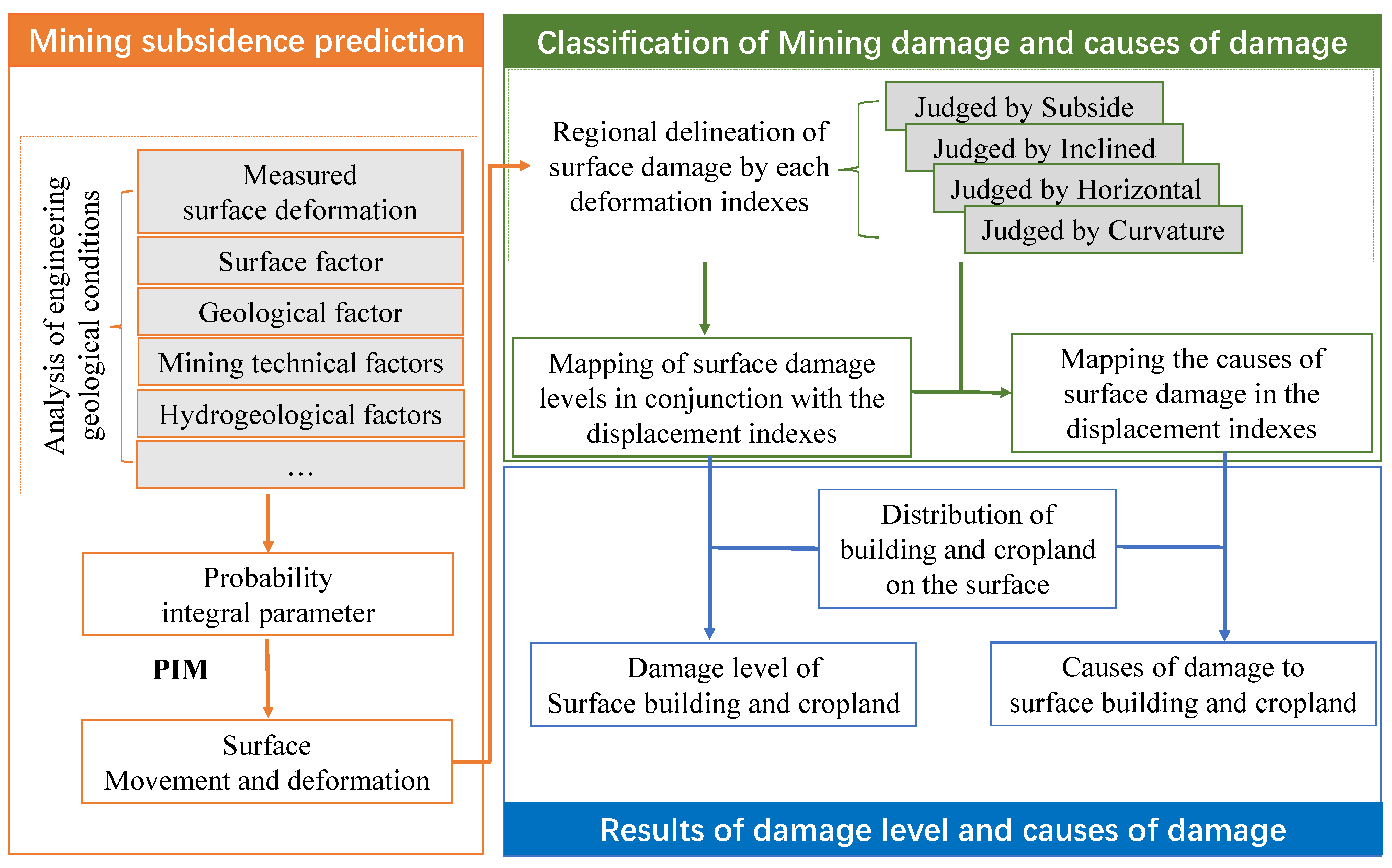
Through the aforementioned analysis, when determining both the level and cause of building and cropland damage on the ground surface, we only need to compare the building and cropland locations on the ground surface with the distribution map of the damage and distribution map of the damage causes in order to work out the result. The overall procedure of this method is shown in Figure 7:

4. Case Analysis

4.1. Overview of the Targeted Area

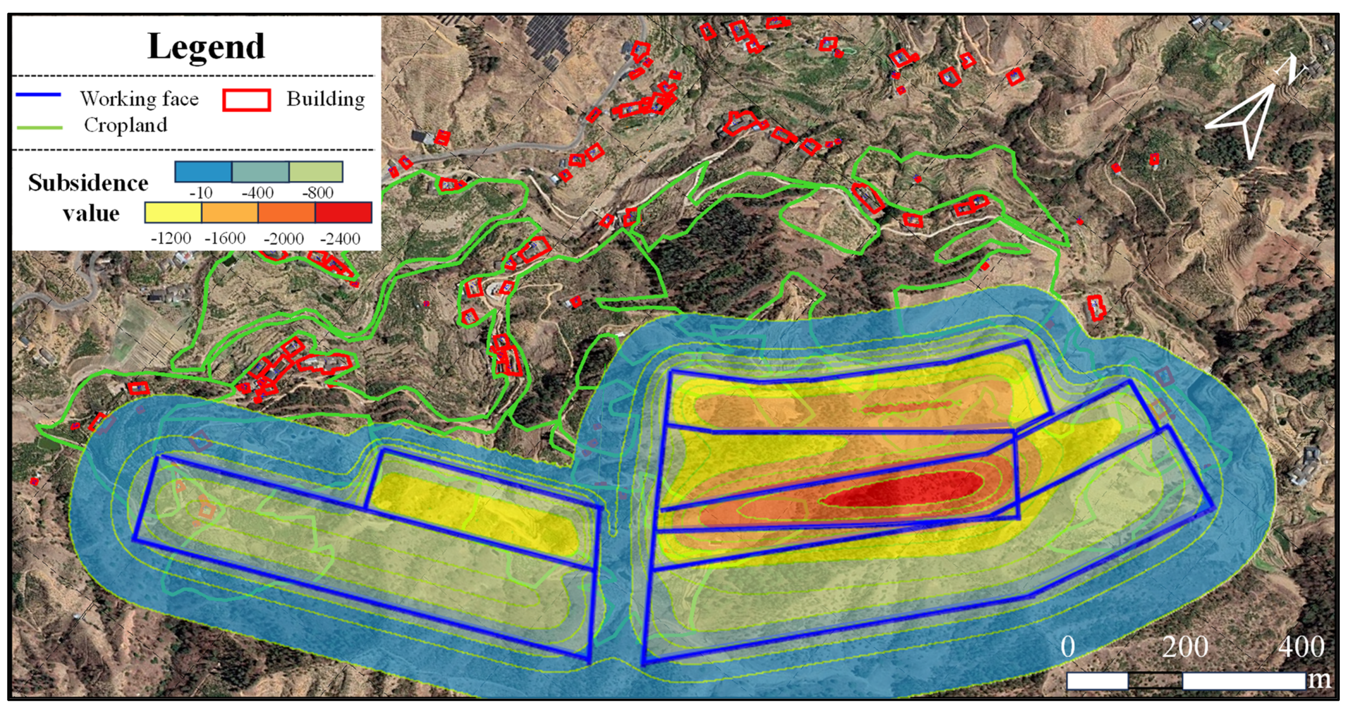
A given mine in China was taken as an example here so as to forecast the building and cropland damages on the ground surface in the coal mining subsidence area. This targeted area comprises a total of six work faces in one upper and one lower coal seam. There is some overlapping mining on those work faces. Over 400 residents are living on the surface of the coal-mining-impacted area where there are 98 buildings and 107.25 hm2 of cropland, and those scattered buildings on the ground surface are generally of a masonry structure and those croplands with complicated and irregular boundaries are irrigated cropland. The specific distribution of buildings and croplands, and the deployment of work faces in the targeted area, are as shown in Figure 8.

4.2. Forecast of Displacement and Deformation of Ground Surface

The probability integration parameters are the bases of the forecast of the displacement and deformation of the ground surface through the probability integration method. The surface topography and geomorphology, the physical and mechanical properties of the strata, the coal seam occurrence characteristics, the coal mining technologies and other aspects all impact the surface displacement and deformation. Therefore, those above factors should be taken into full account during the selection of probability integration parameters. Through the reference to observation data on the surface displacement and deformation near similar mining areas, and the comparison of stratigraphic characteristics in the targeted area, the initial mining subsidence coefficient was taken as 0.6 and the repeated mining subsidence coefficient was taken as 0.72, 1.2 times the initial mining. In view of the influences from the coal seam dip angle and surface topography, the uphill angle was taken as 69°; the downhill angle was taken as 63°; the strike displacement angle was taken as 65°; and the probability integration parameters were selected as shown in Table 3:
The mining damage assessment system, based on the independently researched and developed probability integration method, was adopted to determine the displacement and deformation of the ground surface [42]. Surface displacement and deformation caused by coal mining is a spatial and temporal process. Therefore, time works as a key factor for surface displacement and deformation during each round of mining. The “Knothe” time function was introduced in the displacement and deformation forecast system based on the probability integration method in this research, so as to correct the displacement and deformation. In order to ensure long-term building stability and a stabilized ground surface, the displacement and deformation values after 20 years of initial mining were selected for the deformation forecast. By virtue of Arc GIS 10.2, the Kriging algorithm was adopted to interpolate the points on the ground surface with a 1 m step, and then the point-to-raster function was adopted to convert the displacement and deformation data at each point in the targeted area into 1 × 1 m raster cells and to generate the deformation cloud chart. Due to the paper length, only the subsidence cloud chart is shown in Figure 9.

4.3. Regional Distribution Results of Comprehensive Damages

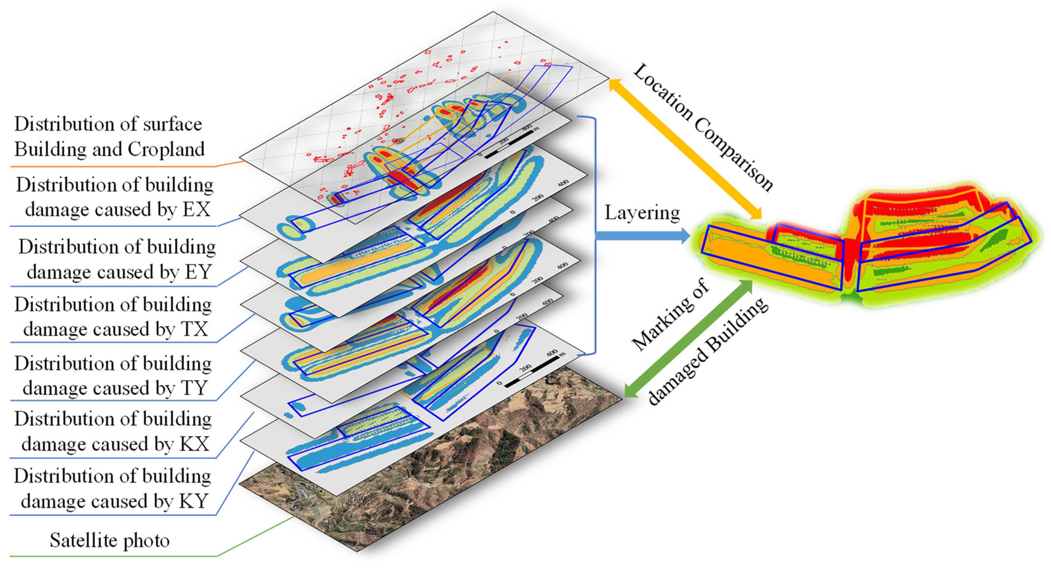
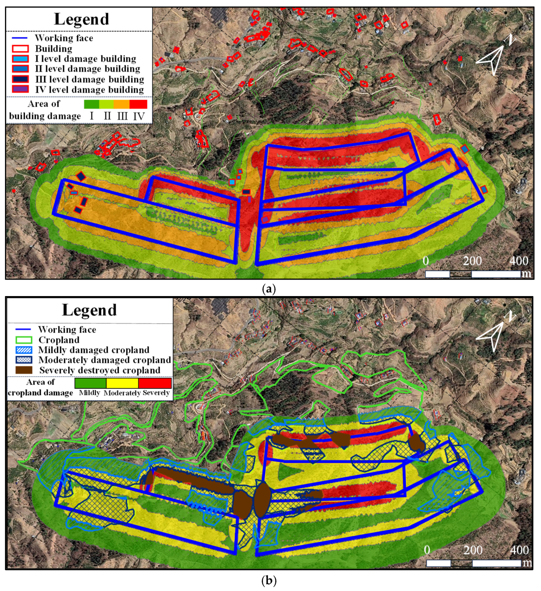
The damage range distribution of the single displacement indexes was determined using the above damage level classification method, and the damage ranges of each index were superimposed to obtain the damaged area, integrating all displacement indexes. Then, the extraction damage quantity was attainable through comparing the damaged area with the building and cropland distribution on the ground surface. The superposition and comparison process was as shown in Figure 10; the regional distribution and results of the obtained building damage were as shown in Figure 11a; and the regional distribution and results of the cropland damage were as shown in Figure 11b.
The raster field was extracted and processed in terms of the comprehensive damage risk area distribution in Figure 11. According to the statistics, the total risk area of coal-mining-induced building damage area on the ground surface was 107.25 hm2; of this, Level-I damage range accounted for the lowest percentage of 6.23% and the percentages of Level-II, III and IV damages were 32.36%, 30.75% and 20.79%, respectively. The total coal-mining-induced cropland damage and destruction risk area was 106.85 hm2; of this, 45.86% of the area was lightly damaged while 42.24% of the area was moderately damaged and 11.90% of the area was severely destroyed.
Through the comparison of the building and cropland distribution in terms of damage range, the coal-mining-induced building and cropland damage quantities are shown in Table 4:
According to the table, the damaged buildings on Levels II and III, due to the coal mining on the work face, was the maximum with a total of five buildings holding, followed by damaged buildings on Level IV where a total of three buildings held, and the damaged building on Level I was the minimum with only one building holding. The mildly damaged croplands area on the ground surface was 11.96 hm2, accounting for 36.60%; the moderately damaged croplands area was 15.34 hm2, accounting for the largest proportion of 46.94%; and the severely destroyed croplands area was 5.37 hm2, accounting for the minimum proportion of 16.45%.

4.4. Distribution Results of Damages Due to Displacement Indexes

A causal analysis of building and cropland damages can provide guidance for building and cropland reconstruction so as to alleviate coal-mining-induced damages. By virtue of GIS, displacement indexes triggering each raster damage were extracted so as to draw the damage cause distribution map. The causes for building and cropland damage and destruction on the ground surface were forecast in light of the building and cropland distribution on the ground surface; the distribution of damage causes and results were as shown in Figure 12, and the damages due to each index were counted as shown in Table 5.
According to those legends, E indicates that only the horizontal deformation reaches the final damage level at this point; E&T indicate that both horizontal deformation and inclined reach the damage level simultaneously at this point; E&T&K indicate that horizontal deformation, inclined and curvature reach the damage level simultaneously at this point; and the rest follow the same rule.
It was estimated that 14 damaged buildings were associated with the displacement indexes E and T, and 7 buildings were damaged by deformation index T, accounting for the maximum proportion of 50%; 5 buildings were damaged by deformation index E and 2 buildings were damaged jointly by both deformation index E and T. Regarding the damaged or destroyed cropland areas, most of them were damaged or destroyed by deformation index T, or jointly by displacement indexes W, E and T, accounting for 33.48% and 30.45%, respectively.

4.5. Quantitative Analysis of Influences of Displacement Indexes on Damages of Each Level

On the basis of the obtained comprehensive damage range (Figure 11), and the damage range due to each index, the law of influence of the displacement indexes on the damage ranges of each level was calculated using Equation (7) by virtue of the Raster Calculator, and the contribution rate of the displacement indexes to the damage risk areas of each level were obtained, as shown in Table 6.
According to Table 6, in the building damage and destruction areas, the contribution rate of curvature K was low while the contribution rates of both horizontal deformation E and inclined T were high. As building damage level was aggravated, the contribution rate of T toward building damage increased while the contribution rate of deformation index E toward building damage decreased. This indicated that the deformation index K caused fewer building damages and that, as damage level aggravated, building damages caused by deformation index T increased while building damages caused by deformation index E decreased.
In the cropland damage and destruction areas, as damage level was aggravated, the contribution rate of deformation index T to damages increased while the contribution rates of displacement indexes W and E to damages decreased. And the contribution rate of deformation index W to severe destruction was 0; this indicated that, as damage level was aggravated, the damaged cropland area due to T increased while the damaged cropland area caused jointly by W and E decreased, and that W failed to trigger serious cropland destruction.
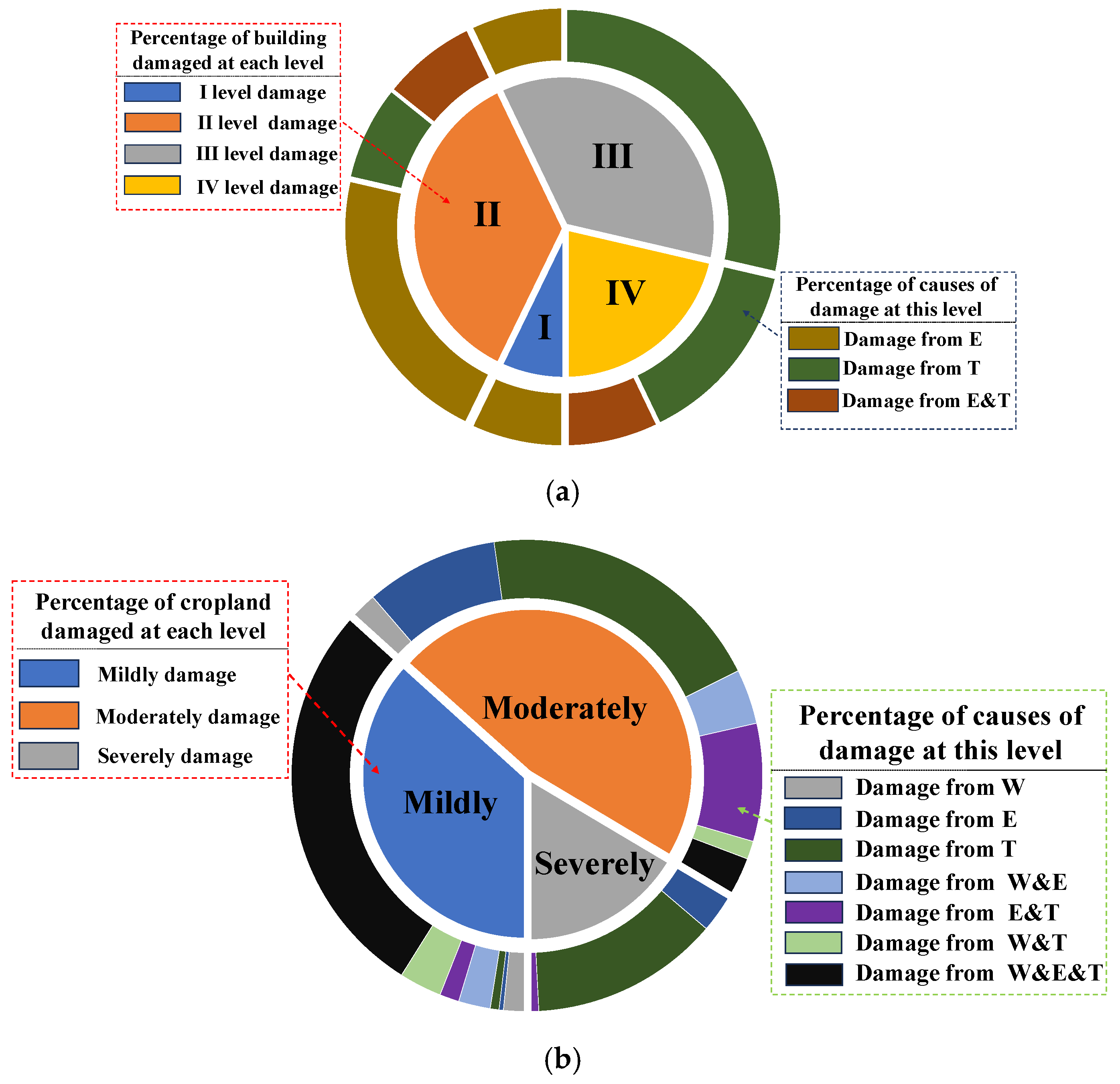
The causes for estimated building and cropland damages were extracted so as to draw Figure 13 for damage cause distribution analysis and to verify the accuracy of the law concerning the influence of displacement indexes on the damages obtained from contribution rate analysis. In the figure, the inner pie chart indicates the proportions of each damage level while the outer doughnut chart indicates the proportions of damage causes corresponding to their damage severities.
According to the causes for 14 estimated damaged buildings in Figure 13a, those building damages were all caused by displacement indexes E and T; among those damaged buildings on Levels I and II, the damages caused by horizontal deformation E accounted for a large proportion. As damage level was aggravated, among those damaged buildings on Levels III and IV, the proportion of building damages caused by deformation index E decreased while the proportion of damages caused by inclined deformation index T increased. According to the estimated cropland damages in Figure 13b, as cropland damage level was aggravated, the proportion of damaged cropland area caused by inclined T increased, while W caused no severe cropland destruction.
Through a comparison of the estimated building and cropland damage cause distribution with the contribution rates of displacement indexes to the damaged areas of each level in Table 6, it was concluded that the distribution law of the contribution rates of displacement indexes to the damaged areas of each level was consistent with the distribution law of building and cropland damage causes, thus indicating that an analysis of damage range contribution rate can accurately reflect the law of each damage level due to deformation index.

5. Mitigation Countermeasures against Building and Cropland Damages in Coal Mining Subsidence Areas

The purpose of mining damage prediction is to identify hazardous areas of buildings and croplands triggered by coal seam mining, and to select reasonable disposal methods for buildings and croplands with different levels of damage when coal seam mining is carried out in the future.
With regard to buildings affected by mining, buildings with low levels of damage are protected by measures such as reinforcement and renovation to ensure the safety of residents. More severely damaged buildings need to be dismantled and relocated and buildings with a high level of protection or those that are difficult to relocate need to be protected by choosing a suitable extraction process. For arable land affected by mining, if the damage caused by mining is low, ecological restoration measures, such as the backfilling of cracks, can be carried out after the surface has been stabilized. If the damage is high, then it can be turned into woodland or used for other non-cultivation purposes.

5.1. Mitigation Countermeasures against Surface Building Damage

Architectural structures influence the overall rigidity and thus determines a building’s deformation resistance. Regarding the architectural structure of a building itself, the following restructuring measures can be made in order to achieve damage mitigation (as shown in Figure 14). (1) Excavate the deformation buffer trench: the coal-mining-induced horizontal surface deformation can be effectively absorbed by trenches with a certain depth around buildings; (2) Establish the deformation joint: the additional bending moment applied upon buildings by surface curvature deformation is proportional to the square of building length; therefore, a slender building is more vulnerable to surface deformation than a square building. The deformation joint established during the construction process of a building can divide the building into several independent units with smaller length but higher rigidity, thus effectively reducing the influence of coal mining upon the building; (3) Establish a steel tie rod and concrete ring beam: such measures can effectively enhance a building’s rigidity and tensile resistance, as well as bending and deformation resistance; (4) Establish the continuous foundation beam: such a measure can effectively enhance a building’s foundation rigidity and thereby reduce the coal-mining-induced damage to the building.
In addition, buildings can be restructured through door and window blocking, beam and column constructing, and other foundation enhancement measures, so as to effectively mitigate the coal-mining-induced damage to buildings themselves.

5.2. Measures for Cropland Reclamation

Although it is much more difficult for us to change the cropland structure than that of buildings, reasonable cropland reclamation measures can be formulated according to those factors like topography, geomorphology, climate environment, groundwater level, etc., in the mining area. (1) Regarding the hilly and mountainous cropland, the land cultivation capacity can be restored simply by coal-mining-induced land crack backfilling. (2) When it comes to a plain with a low groundwater table and low precipitation, if the coal-mining-induced subsidence basin has less water ponding, the land crack backfilling in the subsidence basin can ensure its irrigable capacity; as for the area with water ponding in the subsidence basin, the land should be drained first and then its cracks can be backfilled in order to achieve cropland reclamation.

5.3. Mining-Techniques-Based Damage Mitigation Measures

Reasonable options for mining techniques and measures can effectively control surface displacement and deformation, so as to reduce the surface building and cropland damage severities. The coal-mining-induced surface damages can be mitigated through the following mining techniques. (1) The mining and backfilling method: in this way, coal miners backfill the goaf after their coal mining work. Through the solid waste or the prepared filler left in the goaf [43,44], fillers and coal pillars interact with each other; based on such mechanical mechanism [45,46], they can jointly support the stress from the upper overlying rock mass, so as to control the overlying rock mass displacement and deformation, and to mitigate surface subsidence [47]. The application of mining and backfilling technology can play a significant role in the control of surface deformation, mining-induced solid waste treatment and green coal mining in the “three-under” coal deposit area. (2) Strip mining method: with this method, miners divide the coal seam to be mined into several strips for partial mining, and the pillars are left untouched so as to support the roof rock mass and to thereby mitigate surface subsidence; however, the disadvantage of this method is the low coal yield rate [48,49]. (3) Coordinated and controlled mining: through the rational coal mining layout, miners control the mining speed and the regional coal seam mining thickness [50], so as to mitigate the influence of coal mining on surface buildings and croplands. In addition, the surface displacement and deformation can be controlled from the aspects of the grouting into overlaying but separated rock mass, the roof management and other methods, so as to mitigate the coal-mining-induced damage.
Based on the forecast of building and cropland damage in the coal-mining-impacted area, the conflict between coal mining and ecological and environmental protection can be mitigated through surface building and cropland enhancement, or reasonable coal mining technology adjustment underground, so as to achieve sustainable coal mining.

6. Conclusions

Coal-mining-induced damage forecasts guarantee the safety and economic efficiency of the mining industry. Based on the estimation of displacement and deformation of the ground surface, the building and cropland damage assessment model was established herein so as to further analyze the damage causes:
(1)
The displacement and deformation of the ground surface due to coal mining were analyzed by virtue of GIS, and the damage range on the ground surface was divided by multiple displacement indexes so as to quickly determine and extract the building and cropland damage level and quantity.
(2)
The damage causes were discussed in terms of damage range. The damaged area caused by each deformation index was further divided using the Raster Calculator and the law of the influence of deformation index upon each damage level was quantitatively analyzed by virtue of the contribution rate. The contribution-rate-based damage cause analysis method can effectively reflect the distribution of both building and cropland damage causes.
(3)
A given mine in China was taken for case verification. According to the forecast, 14 buildings suffered from coal-mining-induced damages and 32.67 hm2 of the cropland area was damaged or destroyed in total. A causal analysis of both the building and cropland damages showed that building damage was triggered by inclined T and that seven buildings were destroyed; among them, five buildings were damaged by horizontal deformation E, and two buildings were damaged jointly by E and T. Concerning cropland damage, most of the damaged or destroyed area was caused by inclined T, accounting for 33.48%. As damage level was aggravated, the proportion of building damage caused by E decreased, while the proportion of building damage caused by T increased, and the proportion of damaged cropland area caused by inclined T increased.

Author Contributions

This article is presented by the four authors mentioned, each of whom were responsible for various aspects of the work. Conceptualization, B.Z. and P.C.; Methodology, B.Z. and P.C.; Software, P.C., J.W. and D.Z.; Validation, B.Z. and P.C.; Writing—original draft preparation, B.Z. and P.C.; Writing—review and editing, B.Z., P.C., J.Z. and D.Z.; Supervision, J.W. and J.Z.; Project administration, B.Z.; Funding acquisition, B.Z. All authors have read and agreed to the published version of the manuscript.

Funding

This research was funded by the National Natural Science Foundation of China through Grant No. 52074208.

Institutional Review Board Statement

Not applicable.

Informed Consent Statement

Not applicable.

Data Availability Statement

Not applicable.

Conflicts of Interest

The authors declare no conflict of interest.

References

  1. Huang, J.; Tian, C.; Xing, L.; Bian, Z.; Miao, X. Green and Sustainable Mining: Underground Coal Mine Fully Mechanized Solid Dense Stowing-Mining Method. Sustainability 2017, 9, 1418. [Google Scholar] [CrossRef]
  2. Cao, W.; Wang, X.; Li, P.; Zhang, D.; Sun, C.; Qin, D. Wide Strip Backfill Mining for Surface Subsidence Control and Its Application in Critical Mining Conditions of a Coal Mine. Sustainability 2018, 10, 700. [Google Scholar] [CrossRef]
  3. Wang, J.A.; Shang, X.C.; Ma, H.T. Investigation of catastrophic ground collapse in Xingtai gypsum mines in China. Int. J. Rock Mech. Min. Sci. 2008, 45, 1480–1499. [Google Scholar] [CrossRef]
  4. Solarski, M.; Machowski, R.; Rzetala, M.; Rzetala, M.A. Hypsometric changes in urban areas resulting from multiple years of mining activity. Sci. Rep. 2022, 12, 2982. [Google Scholar] [CrossRef] [PubMed]
  5. Machowski, R. Changes in the Landform and Water Conditions of the Industri-Alized Urban Area as a Result of Mining Activities. Land 2022, 11, 1710. [Google Scholar] [CrossRef]
  6. Wang, W.; Wu, K.; Chen, R.; Wang, R.; Diao, X. Comprehensive evaluation of building damage in mining areas based on GIS and random forest. Coal Sci. Technol. 2022, 50, 201–207. [Google Scholar] [CrossRef]
  7. Saeidi, A.; Deck, O.; Seifaddini, M.; Heib, M.A.; Verdel, T. An improved methodology for applying the influence function for subsidence hazard prediction. Georisk Assess. Manag. Risk Eng. Syst. Geohazards 2022, 16, 347–359. [Google Scholar] [CrossRef]
  8. Chi, S.; Wang, L.; Yu, X. A New Method for Calculating Prediction Parameters of Surface Deformation in the Mining Area. Appl. Sci. 2023, 13, 8030. [Google Scholar] [CrossRef]
  9. Xuan, D.; Xu, J. Grout injection into bed separation to control surface subsidence during longwall mining under villages: Case study of Liudian coal mine, China. Nat. Hazards 2014, 73, 883–906. [Google Scholar] [CrossRef]
  10. Yang, X.; Lei, S.; Shi, Y.; Wang, W. Effects of Ground Subsidence on Vegetation Chlorophyll Content in Semi-Arid Mining Area: From Leaf Scale to Canopy Scale. Int. J. Environ. Res. Public Health 2023, 20, 10493. [Google Scholar] [CrossRef]
  11. Bell, F.G.; Stacey, T.R.; Genske, D.D. Mining subsidence and its effect on the environment: Some differing examples. Environ. Geol. 2000, 40, 135–152. [Google Scholar] [CrossRef]
  12. Zhao, B.; Guo, Y.; Wang, W.; He, S. Impact of Underground Coal Seam Mining on Stability and Slippage of the Loess Slope. Sustainability 2023, 15, 6485. [Google Scholar] [CrossRef]
  13. Liu, X.; Guo, G.; Li, H. Study on Damage of Shallow Foundation Building caused by Surface Curvature Deformation in Coal Mining Area. KSCE J. Civ. Eng. 2019, 23, 4601–4610. [Google Scholar] [CrossRef]
  14. Trzałkowski, P. Some Remarks on Impact of Mining Based on an Example of Building Deformation and Damage Caused by Mining in Conditions of Upper Silesian Coal Basin. Pure Appl. Geophys. 2019, 176, 2595–2605. [Google Scholar] [CrossRef]
  15. Gayarre, F.L.; Álvarez-Fernández, M.I.; González-Nicieza, C.; Álvarez-Vigil, A.E.; García, G.H. Forensic analysis of buildings affected by mining subsidence. Eng. Fail. Anal. 2010, 17, 270–285. [Google Scholar] [CrossRef]
  16. Can, E.; Kuşcu, Ş.; Kartal, M.E. Effects of mining subsidence on masonry buildings in Zonguldak hard coal region in Turkey. Environ. Earth Sci. 2012, 66, 2503–2518. [Google Scholar] [CrossRef]
  17. Cui, X.M.; Zhang, B.; Peng, C. Current status and progress on the estimation of mining induced building damage. J. China Coal Soc. 2015, 40, 1718–1728. [Google Scholar] [CrossRef]
  18. Kwinta, A.; Gradka, R. Analysis of the damage influence range generated by underground mining. Int. J. Rock Mech. Min. Sci. 2020, 128, 104263. [Google Scholar] [CrossRef]
  19. Chen, Y.; Hu, Z.; Li, P.; Li, G.; Yuan, D.; Guo, J. Assessment and Effect of Mining Subsidence on Farmland in Coal–Crop Overlapped Areas: A Case of Shandong Province, China. Agriculture 2022, 12, 1235. [Google Scholar] [CrossRef]
  20. Zhang, Y.; Hu, Z.; Han, J.; Liu, X.; Feng, Z.; Zhang, X. Spatiotemporal Relationship between Ecological Restoration Space and Ecosystem Services in the Yellow River Basin, China. Land 2023, 12, 730. [Google Scholar] [CrossRef]
  21. Zhao, X.; Li, J.; Liu, Z.; Li, W.; Zhang, P.; Zhou, S. Evaluation of Damaged Farmland Extent in Overlapped Areas of Farmland and Coal Resources with High Phreatic Water Level. Environ. Sci. Technol. 2014, 37, 177–181+192. [Google Scholar]
  22. Jin, H.; Bai, Z.; Zhou, W.; Wang, J.; Li, S. Case Study on rehabilitation FEE of Destroyed Farmland in Coal Mines in Loess Hilly Terrain. Resour. Ind. 2013, 15, 111–117. [Google Scholar] [CrossRef]
  23. Esaki, T.; Djamaluddin, I.; Mitani, Y. A GIS-based prediction method to evaluate subsidence-induced damage from coal mining beneath a reservoir, Kyushu, Japan. Q. J. Eng. Geol. Hydrogeol. 2008, 41, 381–392. [Google Scholar] [CrossRef]
  24. Kim, K.D.; Lee, S.; Oh, H.J.; Choi, J.K.; Won, J.S. Assessment of ground subsidence hazard near an abandoned underground coal mine using GIS. Environ. Geol. 2006, 50, 1183–1191. [Google Scholar] [CrossRef]
  25. Feng, Q.; Liu, G.; Lei, M.; Fu, E.; Zhang, H.; Zhang, K. Land subsidence induced by groundwater extraction and building damage level assessment—A case study of Datun, China. J. China Univ. Min. Technol. 2008, 18, 556–560. [Google Scholar] [CrossRef]
  26. Nadudvari, A. Using radar interferometry and SBAS technique to detect surface subsidence relating to coal mining in Upper Silesia from 1993–2000 and 2003–2010. Environ. Socio-Econ. Stud. 2016, 4, 24–34. [Google Scholar] [CrossRef]
  27. Yuan, Y.; Li, S.; Zhang, Q.; Li, L.; Shi, S.; Zhou, Z. Risk assessment of water inrush in karst tunnels based on a modified grey evaluation model: Sample as Shangjiawan Tunnel. Geomech. Eng. 2016, 11, 493–513. [Google Scholar] [CrossRef]
  28. Akcin, H. A GIS-based building risk assessment for the subsidence due to undercity coal mining activities in Zonguldak, Turkey. Arab. J. Geosci. 2021, 14, 376. [Google Scholar] [CrossRef]
  29. Zhang, X.Q. Damage Assessment Visualization Research on the Ground Buildings of Village by Coal Mining. Master’s Thesis, Taiyuan University of Technology, Taiyuan, China, 2015. Available online: https://kns.cnki.net/KCMS/detail/detail.aspx?dbname=CMFD201502&filename=1015603809.nh (accessed on 20 August 2023).
  30. Huang, H. Analysis of Mining Subsidence of Loess and Damage Evaluation. Master’s Thesis, Xi’an University of Science and Technology, Xi’an, China, 2017. Available online: https://kns.cnki.net/KCMS/detail/detail.aspx?dbname=CMFD201801&filename=1017725608.nh (accessed on 19 August 2023).
  31. Tan, X.; Song, B.; Bo, H.; Li, Y.; Wang, M.; Lu, G. Extraction of Irregularly Shaped Coal Mining Area Induced Ground Subsidence Prediction Based on Probability Integral method. Appl. Sci. 2020, 10, 6623. [Google Scholar] [CrossRef]
  32. Malinowska, A.; Hejmanowski, R.; Dai, H. Ground movements modeling applying adjusted influence function. Int. J. Min. Sci. Technol. 2020, 30, 243–249. [Google Scholar] [CrossRef]
  33. National Coal Bureau of the People’s Republic of China. Regulation of Mining and Pillar Leaving under Building, Water-Body, Railway and Main Underground Engineer; Coal Industry Press: Beijing, China, 2000; pp. 81–90. (In Chinese)
  34. Zhao, B. The System of Prediction Evaluation on Mining Damage. Master’s Thesis, Xi’an University of Science and Technology, Xi’an, China, 2005. [Google Scholar]
  35. Li, P.; Tan, Z.; Yan, L. A Shaft Pillar Mining Subsidence Calculation Using Both Probability Integral Method and Numerical Simulation. CMES-Comput. Model. Eng. Sci. 2018, 117, 231–249. [Google Scholar] [CrossRef]
  36. Zhao, K.; Xu, N.; Mei, G.; Tian, H. Predicting the distribution of ground fissures and water-conducted fissures induced by coal mining: A case study. SpringerPlus 2016, 5, 977. [Google Scholar] [CrossRef] [PubMed]
  37. Zhang, P. Research on GIS Visualization Evaluation System of Main Environmental Resources Damage in Subsidence Area. Master’s Thesis, Qingdao University of Technology, Qingdao, China, 2009. [Google Scholar]
  38. Liao, M.G. Research on Damage Characteristics and Evaluation Index of Building Caused by Mining in Plain Village. Ph.D. Thesis, China University of Mining and Technology (Beijing), Beijing, China, 2015. [Google Scholar]
  39. He, T.; Xiao, W.; Zhao, Y.; Chen, W.; Deng, X.; Zhang, J. Continues monitoring of subsidence water in mining area from the eastern plain in China from 1986 to 2018 using Landsat imagery and Google Earth Engine. J. Clean. Prod. 2021, 279, 123610. [Google Scholar] [CrossRef]
  40. Hu, Z.; Shao, F.; McSweeney, K. Reclaiming subsided land with Yellow River sediments: Evaluation of soil-sediment columns. Geoderma 2017, 307, 210–219. [Google Scholar] [CrossRef]
  41. D/T 1031.3-2011; Regulations for the Preparation of Land Reclamation Programs Part 3: Shaft Coal Mines. Ministry of Land and Resources of the People’s Republic of China: Beijing, China, 2011. (In Chinese)
  42. Zhang, L.; Wang, J.; Feng, Y. Life cycle assessment of opencast coal mine production: A case study in Yimin mining area in China. Environ. Sci. Pollut. Res. 2018, 25, 8475–8486. [Google Scholar] [CrossRef]
  43. Smoliński, A.; Malashkevych, D.; Petlovanyi, M.; Rysbekov, K.; Lozynskyi, V.; Sai, K. Research into Impact of Leaving Waste Rocks in the Mined-Out Space on the Geomechanical State of the Rock Mass Surrounding the Longwall Face. Energies 2022, 15, 9522. [Google Scholar] [CrossRef]
  44. Malashkevych, D.; Petlovanyi, M.; Sai, K.; Zubko, S. Research into the coal quality with a new selective mining technology of the waste rock accumulation in the mined-out area. Min. Miner. Depos. 2022, 16, 103–114. [Google Scholar] [CrossRef]
  45. Xin, J.; Jiang, Q.; Gong, F.; Liu, L.; Liu, C.; Liu, Q.; Yang, Y.; Chen, P. Mechanical behaviors of backfill-rock composites: Physical shear test and back-analysis. J. Rock Mech. Geotech. Eng. 2024, 16. [Google Scholar]
  46. Xin, J.; Jiang, Q.; Li, S.; Chen, P.; Zhao, H. Fracturing and energy evolution of rock around prefabricated rectangular and circular tunnels under shearing load: A comparative analysis. Rock Mech. Rock Eng. 2023, 1–18. [Google Scholar]
  47. Bai, E.; Guo, W.; Tan, Y.; Huang, G.; Guo, M.; Ma, Z. Roadway Backfill Mining with Super-High-Water Material to Protect Surface Buildings: A Case Study. Appl. Sci. 2020, 10, 107. [Google Scholar] [CrossRef]
  48. Guo, W.J.; Wang, H.L.; Chen, S.J. Coal pillar safety and surface deformation characteristics of wide strip pillar mining in deep mine. Arab. J. Geosci. 2016, 9, 137. [Google Scholar] [CrossRef]
  49. Esterhuizen, G.S.; Dolinar, D.R.; Ellenberger, J.L. Pillar strength in underground stone mines in the United States. Int. J. Rock Mech. Min. Sci. 2011, 48, 42–50. [Google Scholar] [CrossRef]
  50. Guo, W.; Tan, Y.; Bai, E. Top coal caving mining technique in thick coal seam beneath the earth dam. Int. J. Min. Sci. Technol. 2017, 27, 165–170. [Google Scholar] [CrossRef]
Figure 1. The building and cropland damages due to underground coal mining.
Applsci 13 10136 g001
Figure 2. Space coordinate system by probability integration method.
Applsci 13 10136 g002
Figure 3. The schematic diagram on indexes of displacement and deformation of ground surface.
Applsci 13 10136 g003
Figure 4. The characteristics of building damages caused by different deformation indexes: (a) Positive horizontal deformation; (b) Negative horizontal deformation; (c) +k Positive curvature deformation [10−3/m]; (d) Negative curvature deformation [10−3/m]; (e) Inclined deformation [10−3/m].
Applsci 13 10136 g004
Figure 5. Process for the regional delineation of surface damage classes in mining-affected areas.
Applsci 13 10136 g005
Figure 6. The schematic diagram of GIS-superimposed analysis.
Applsci 13 10136 g006
Figure 7. The comprehensive assessment and analysis procedure for coal-mining-induced damage.
Applsci 13 10136 g007
Figure 8. The distribution map of buildings and croplands on the ground surface in the mining area.
Applsci 13 10136 g008
Figure 9. The cloud chart on ground surface subsidence due to coal mining on the work face.
Applsci 13 10136 g009
Figure 10. Schematic of damage range superposition and damage level judgment.
Applsci 13 10136 g010
Figure 11. The forecast of building and cropland damage range and level integrating multiple displacement indexes: (a) Building; (b) Cropland.
Applsci 13 10136 g011
Figure 12. The distribution map of building and cropland damage causes: (a) Building; (b) Cropland.
Applsci 13 10136 g012
Figure 13. The combined number–cause chart of building and cropland damages of each level. (a) The numbers and the cause proportions of building damages of each level; (b) The areas and the cause proportions of building damages of each level.
Applsci 13 10136 g013
Figure 14. Restructuring measures for coal-mining-induced damage mitigation.
Applsci 13 10136 g014
Table 1. The classification standard for coal-mining-induced building damages.
Damage LevelSurface Movement Deformation Thresholds
Horizontal
Deformation (mm/m)
Curvature
Deformation (10−3/m)
Inclined
Deformation (10−3/m)
I≤2.0≤0.2≤3.0
II2.0~4.00.2~0.43.0~6.0
III4.0~6.00.4~0.66.0~10.0
IV>6.0>0.6>10.0
Table 2. The classification standard for coal-mining-induced cropland damages.
Damage LevelSurface Movement Deformation Thresholds
Subsidence (mm)Horizontal
Deformation (mm/m)
Inclined
Deformation (10−3/m)
mildly damaged≤1500≤4.0≤6.0
moderately damaged1500~30004.0~8.06.0~12.0
severely destroyed>3000>8.0>12.0
Table 3. Probability integration parameter selection.
Coal SeamSubsidence FactorHorizontal
Movement Factor
Uphill Angle
of Critical Deformation (°)
Downhill Angle
of Critical Deformation (°)
Offset Distance
of Inflection Point
210.60.369650.1 H
170.720.369650.1 H
Table 4. The statistical table on coal-mining-induced damages on the ground surface.
Damage levelIIIIIIIVTotal
Number of building damages/size155314
Damage levelMildly damagedModerately damagedSeverely destroyedApplsci 13 10136 i001Total
Cropland area/hm211.9615.345.3732.67
Table 5. The statistical table of deformation index-triggered damages on the ground surface.
Damage reasonETJE&TT&KE&KE&T&KTotal
Number of house damages/size570200014
Damage reasonWETW&EE&TW&TW&E&TTotal
Cropland area/hm21.193.9510.941.943.341.369.9532.67
Table 6. The contribution rates of displacement to building and cropland damage risk areas of different severities.
Damage LevelContribution Rate of Each Deformation Index to Building Damage (%)
ETK
I69.5328.302.17
II54.7940.474.74
III36.163.850.05
IV32.9667.030.01
Damage LevelContribution Rate of Each Deformation Index to Cropland Damage (%)
WET
mildly damaged33.3832.6833.94
moderately damaged14.429.0956.51
severely destroyed021.7478.26
Disclaimer/Publisher’s Note: The statements, opinions and data contained in all publications are solely those of the individual author(s) and contributor(s) and not of MDPI and/or the editor(s). MDPI and/or the editor(s) disclaim responsibility for any injury to people or property resulting from any ideas, methods, instructions or products referred to in the content.