Abstract
Rainfall is the main cause of erosion damage in loose slope deposits. During rainfall infiltration, fine particles in the soil mass will move with water infiltration, thus changing the localized particle distribution of the soil mass, which, in turn, causes changes in the pore water pressure and volumetric water content within the slope and ultimately affects slope stability. In order to develop advanced soil and water conservation programs to prevent slope damage, it is crucial to understand and accurately reproduce the particle migration and aggregation characteristics of soils under different rainfall conditions. Therefore, this paper systematically investigates the soil particle migration characteristics of the soil body under rainfall conditions by simulating the internal erosion of the lateritic soil slope body under rainfall conditions via slope internal erosion simulation experiments and experimentally analyzing the migration and aggregation of fine particles in the slope body, as well as the changed rules regarding pore water pressure and volumetric water content at different locations of the slope body with rainfall. The results of this study show that (1) with the infiltration of rainfall, the fine particles in the slope body mainly infiltrate in the vertical direction in an early stage of rainfall; in a later stage, there is vertical downward and down-slope seepage. Therefore, fine particles always gather at the toe of the slope, which leads to relatively high water content and pore water pressure at the toe of the slope, and thus, the slope is always damaged from the toe of the slope. (2) Inside the slope, the fine particles always gather at the smallest pore diameter. With the enhancement of hydrodynamic force, they will be lost again, which leads to a sudden decrease in the local volumetric water content of the slope, and the pore space increases. Then, it is filled with seepage water, which makes the pore water pressure fluctuate or increase. (3) Based on the particle distribution parameter, the present study produced a distribution map of the fine particle content of the slope body under different rainfall intensities and established a model of the dynamic change of fine particles, which improves the understanding of the effect of the change in the fine particle composition of the slope body on the water content and the pore water pressure and may be helpful for the assessment of the initiation of the mudslides.
1. Introduction
Slope stability is the ability of a slope to remain stable under its own gravity and external forces. The strength and stability of soil are the key factors affecting slope stability. Internal erosion will change the physical and mechanical properties of soil, which will have an impact on slope stability. Under rainfall infiltration, the internal erosion of the slope body will lead to changes in the porosity, water content, and pore water pressure of the soil body, which will reduce the strength of the soil body and ultimately lead to instability and damage. When water infiltration erodes soil slopes, fine particles will migrate with water infiltration, and this migration can be categorized into two: fine particles are lost outside the slope with water, and fine particles migrate inside the soil body. Both forms of migration will change the particle distribution of the slope body and thus change the physical properties of the soil body [1]. Among them, for soil pore water pressure, the presence and number of fine particles can significantly affect the pore water pressure [2,3,4]. For example, the vertical migration of fine particles in the slope profile affects the change of pore water pressure, and, in some cases, the effect of fine particle migration is more significant than the effects of mass and depth [5]. In addition, the content of fine particles has a significant effect on soil water content, and soil water-holding properties are closely related to particle composition [6], with particles of different sizes responding differently to water. Compared with large particles, small particles have a larger specific surface area, which makes it easier for small particles to absorb water [7], so the higher the relative content of soil fine particles, the higher the water content should be. In addition, the amount of fine particles somewhat changes the strength properties of the soil. For example, parameters such as matrix suction, cohesion, and shear strength of soil increase with increasing clay content [8]. Fine particles absorb water and swell under rainfall, filling the soil pores, reducing the pore space, growing the water flow path, increasing the contact area between the soil and water, and enhancing the viscous effect on water flow, which leads to a decrease in the permeability of the soil [9]. During rainfall, the migration and aggregation of fine particles in the slope body will lead to changes in the particle size distribution of the soil body, which will further affect key parameters such as pore water pressure, water content, and permeability characteristics of the soil body. Therefore, the influence of internal erosion on slope stability is a complex process involving changes in several key parameters such as soil porosity, water content, pore water pressure, and particle distribution. Through an in-depth study of these changes, the mechanism of internal erosion on slope stability can be better understood, providing a scientific basis for slope engineering design and risk assessment.
The stability of soil slopes is affected by erosion within the soil body, and this erosion process refers to the transport of fine particles located in the interstices of the coarse particles of the skeleton under the action of seepage. In this case, the coarse particles form the soil skeleton, while the fine particles are free to move in the coarse skeleton under the action of seepage forces [10,11,12,13]. During heavy rainfall, fine particles in the slope flow between gravels, but due to the limitation of pore size, some fine particles will gather in the slope during transportation [14]; others converge to the lower part of the slope and the toe of the slope and ultimately lead to the destruction of the slope [15,16,17]. The transport of fine particles will lead to changes in the distribution of soil particles in the slope, which will affect the physical and mechanical properties of the soil and, thus, the stability of the slope. In the study of fine particle transport and aggregation, scholars have experimented with different objects, ranging from specific soils (e.g., bimodal unstable soils) or configured lateritic soils with artificially controlled coarse and fine particle occupancy ratios, and the use of glass bead assemblies to replace soils. Although these experimental objects are more or less capable of reproducing the migration behavior of fine particles in slopes, the soil composition is complex and diverse, i.e., the soil is a complex system consisting of a continuous combination of particles. Therefore, this paper introduces the soil scale distribution function to study the migration of fine particles in the slope. First of all, the scalar distribution function has a very high fit to the particle distribution of various types of soils, and the parameters derived from this function have different responses to different soil bodies, which are characterized by universality. Among them, the spatial variation and distribution of the fine particle content characterization parameter μ value derived from the distribution function can accurately portray the spatial heterogeneity of soil particles. By tracking the dynamic changes of this fine particle content characterization parameter under rainfall conditions, the migration and aggregation of fine particles in the slope can be accurately analyzed and explained. Therefore, this approach can consider the complexity and diversity of the soil body more comprehensively and help understand the migration behavior of fine particles in the slope body.
2. Research Background and Experimental Design
2.1. Characteristics of Soil Erosion in the Study Area
2.1.1. Erosion Profile
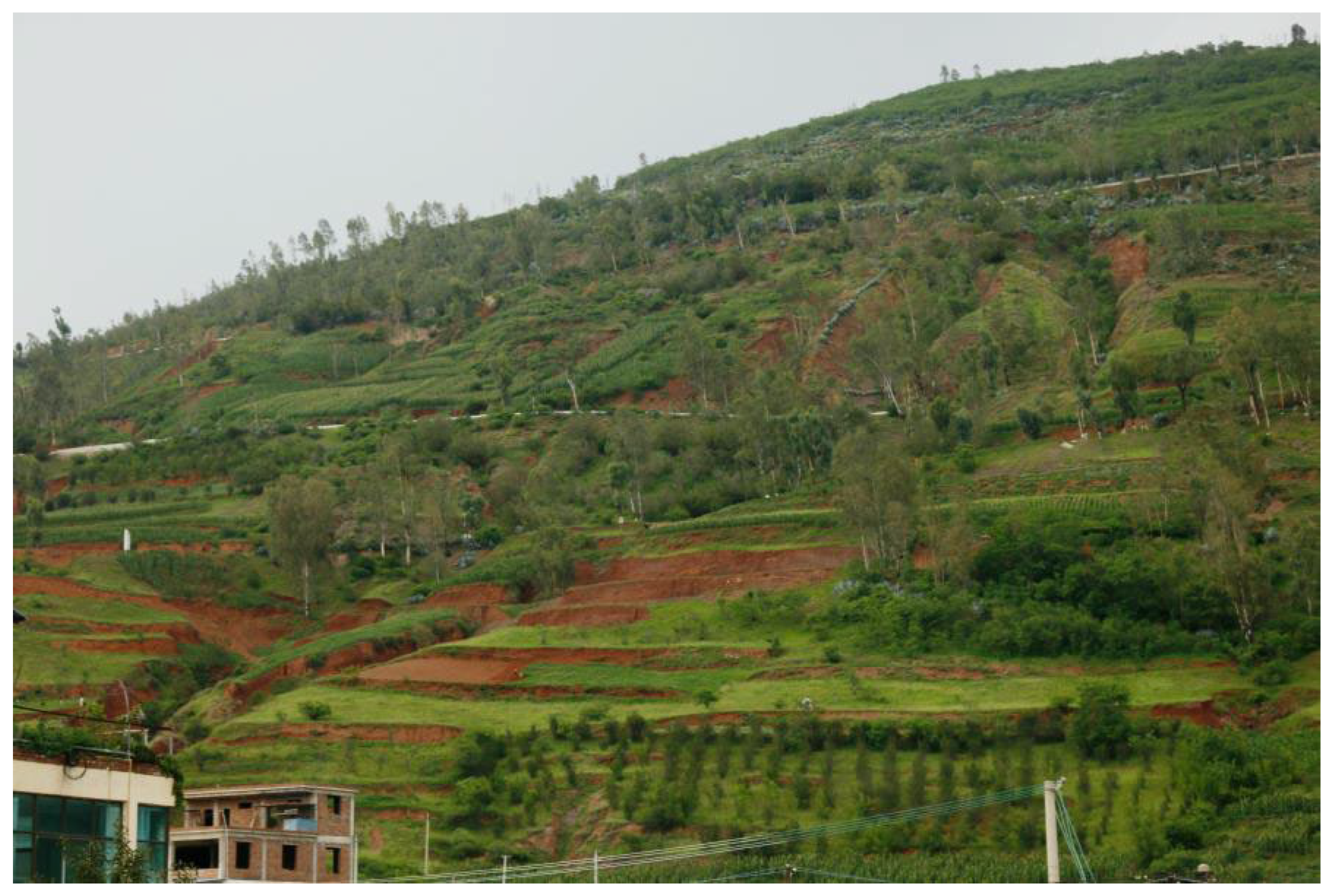
The 110 catastrophic debris flow gullies in the Xiaojiang River Basin, represented by Jiangjiagou, form serious soil erosion, and a large amount of sediment enters the Jinsha River, and the amount of sediment that enters the Xiaojiang River in the territory of Dongchuan City, Yunnan Province, alone is as high as 30 to 40 million tons per year [18]. Therefore, in order to gain a deeper understanding of the mechanism and influencing factors of soil erosion, simulation experiments of soil internal erosion were carried out. In order to simulate the properties and behaviors of real soils, it is crucial to select suitable experimental materials. As a widely distributed soil type in the Xiaojiang River Basin, laterite has a representative and important engineering application background. The study of laterite soil in slope engineering, soil conservation, and soil and water conservation is of great value. Secondly, lateritic soils have high erodibility in the Xiaojiang watershed and are susceptible to rainfall scouring and internal erosion, as shown in Figure 1. And the particle composition and pore structure characteristics have an important influence on the internal erosion process. Therefore, choosing laterite as the experimental material can better simulate the mechanism and influencing factors of soil internal erosion in order to explore the migration of fine particles under rainfall conditions. This will help to reveal the mechanism and influencing factors of internal erosion in laterite soils, as well as the relationship with slope stability, and provide assistance in erosion control and debris flow initiation assessment in the area.
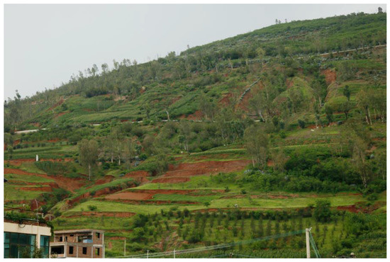
Figure 1.
Presentation of an example of a laterite soil slope subjected to erosion.
2.1.2. Soil Characteristics
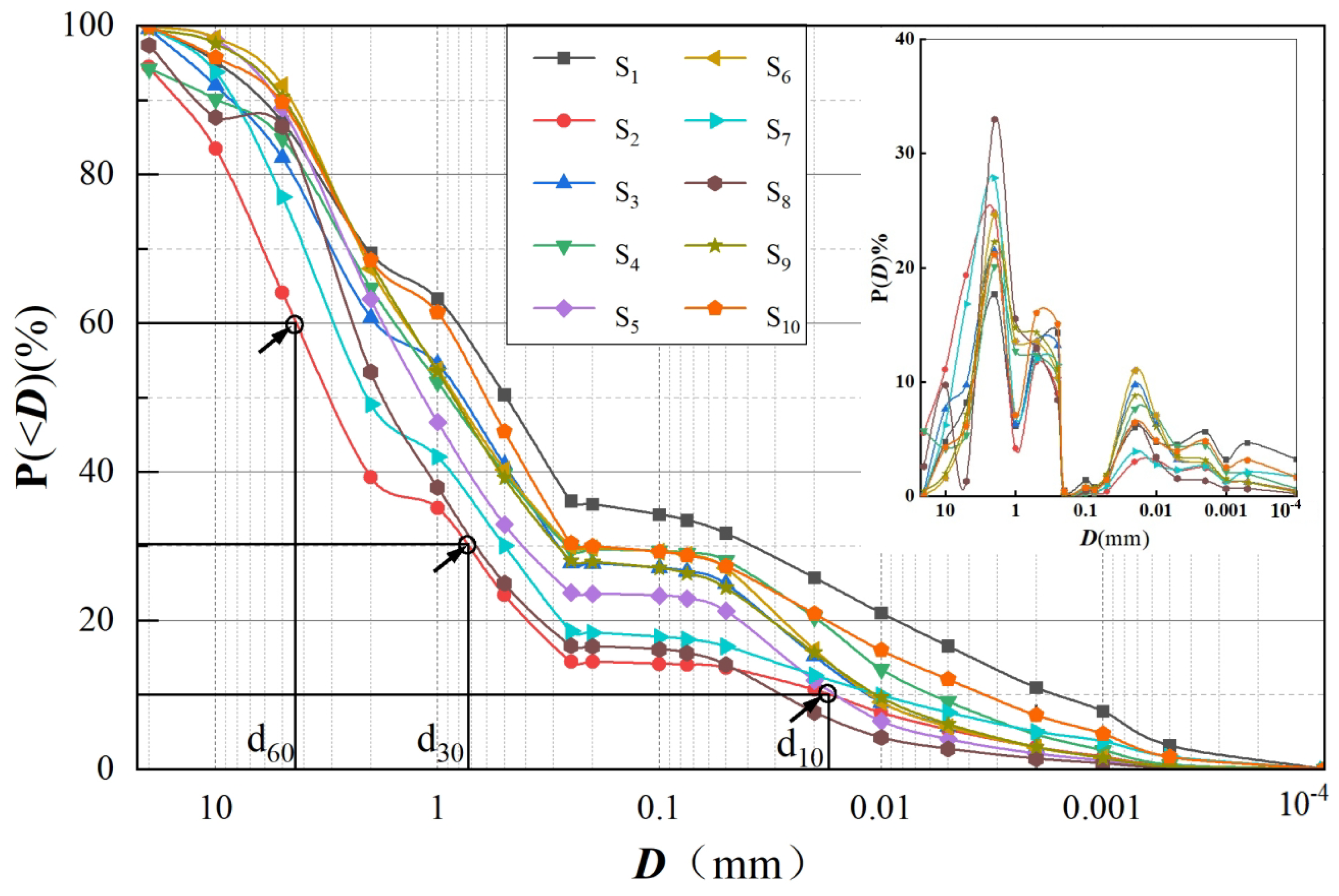
In this study, we selected samples from the laterite distribution area near the mudslide channel of Dongchuan Jiangjia Gully. This lateritic soil contains some gravels, and the gravels are dominated by feldspars and quartz. Ten sets of laterite soil samples were randomly collected in the field from a depth of 30 cm below the surface of the slope. Testing revealed that the dry density of the soil is 1.6 ± 0.1 g/cm3, and the laterite soil particle size curves and frequency curves of these 10 sets of samples are shown in Figure 2. The laterite soil was inhomogeneous with a coefficient of inhomogeneity of Cu = 500 ± 100, which made it inhomogeneous; the frequency curves were in a three-peak pattern, and the frequency was the highest for soil particles of particle size of about 2 mm, the second highest for 3.5 mm, and the lowest for 5.5 mm. According to the soil particle size classification standard made in the United States in 1951, the soil particle size was divided into clay (<0.002 mm), silt (0.002~0.05 mm), and sand (0.05~2.0 mm), and in accordance with the USDA Soil Texture Triangle Classification of the United States Department of Agriculture, which is commonly used in the world; these 10 groups of samples were all distributed in the lower left corner of the triangle diagram, which were mainly loamy sand and sandy loam.
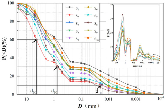
Figure 2.
Accumulation curve and frequency curve of lateritic soil particle size gradation(The arrow in the figure indicates the three characteristic particle sizes of soil sample S1).
2.2. Soil Particle Analysis Methods
Scalar Distribution
The soil scale distribution is obtained based on a universal soil particle size distribution function proposed and developed in recent years. Its distribution function is in the form of a combination of a negative power function and an exponential function [19,20,21]:
where: P(D) is the percentage of particles larger than D; D is the particle size, mm; C is the real coefficient; C, μ, and Dc are parameters determined using the frequency distribution (percentage of particle composition). The distribution functions μ and Dc can be used as characteristic parameters of soil particles. Among them, the parameter μ portrays the content of fine particles in the soil, and the parameter Dc represents the range of soil particle sizes, which can be used as a parameter of coarse particle composition [22,23,24,25,26]. In this paper, we mainly use the spatial variation and distribution of the parameter μ value to portray the spatial heterogeneity of soil particles and track the migration characteristics of soil fine particles under rainfall conditions.
P(D) = C D−μ exp(−D/Dc),
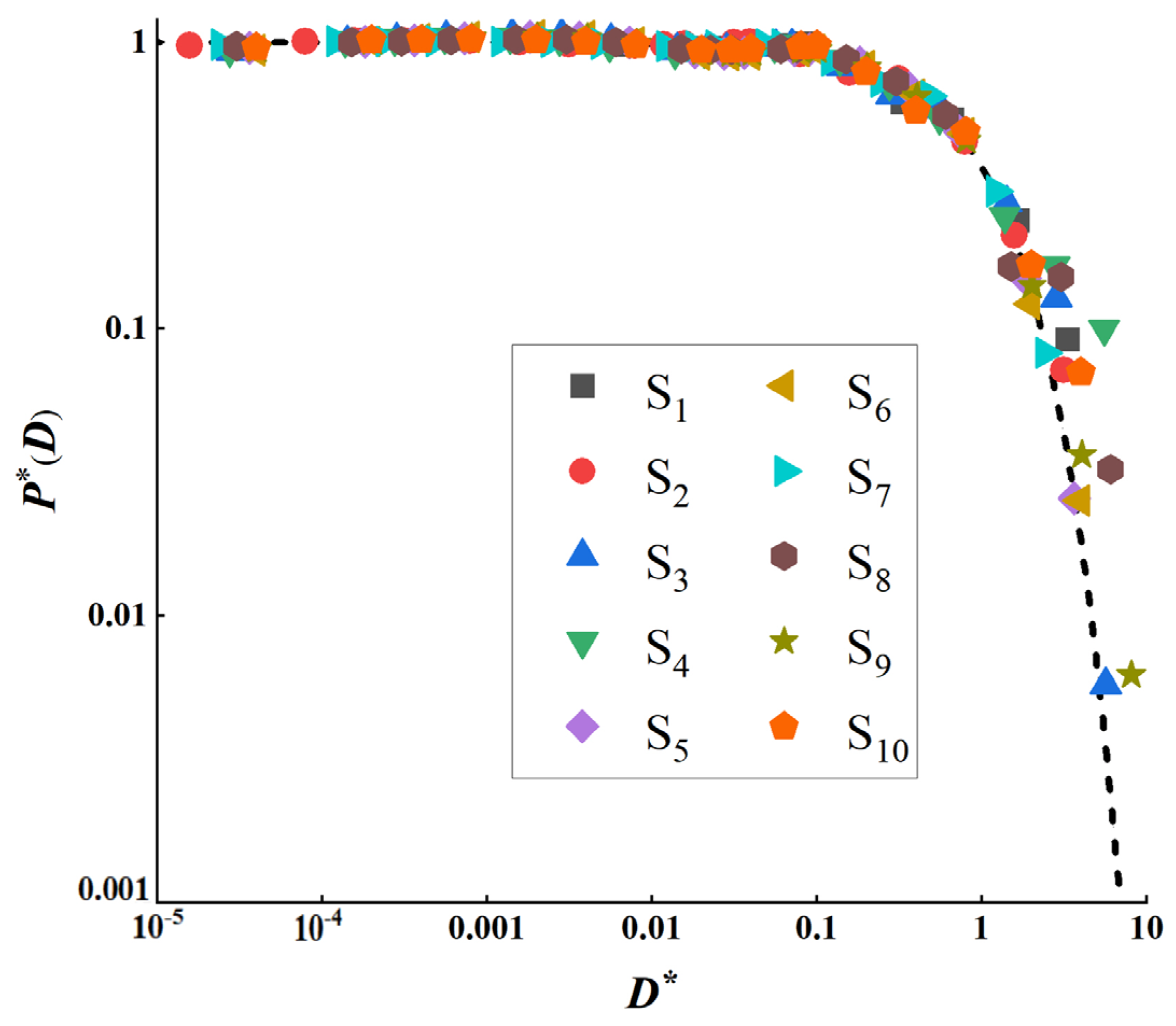
Table 1 lists the characteristic parameters of the 10 samples collected in the field. In order to understand the scaled distribution function more intuitively, the function is rescaled coordinates so that D* = D/Dc and P*(D) = DμP(D)/C; then, the distribution curves of different soil samples fall into the same exponential curve under the new coordinates D* − P*(D), as shown in Figure 3.

Table 1.
Gradation coefficients of lateritic soils.
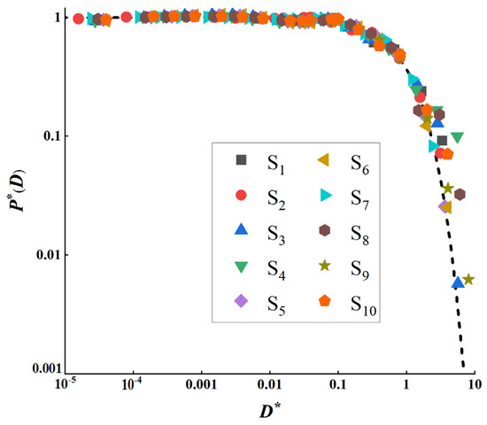
Figure 3.
Exponential distribution of grain size of lateritic soil(In the figure, D* = D/Dc, P*(D) = DμP(D)/C).
2.3. Experimental Design
2.3.1. Experimental Setup
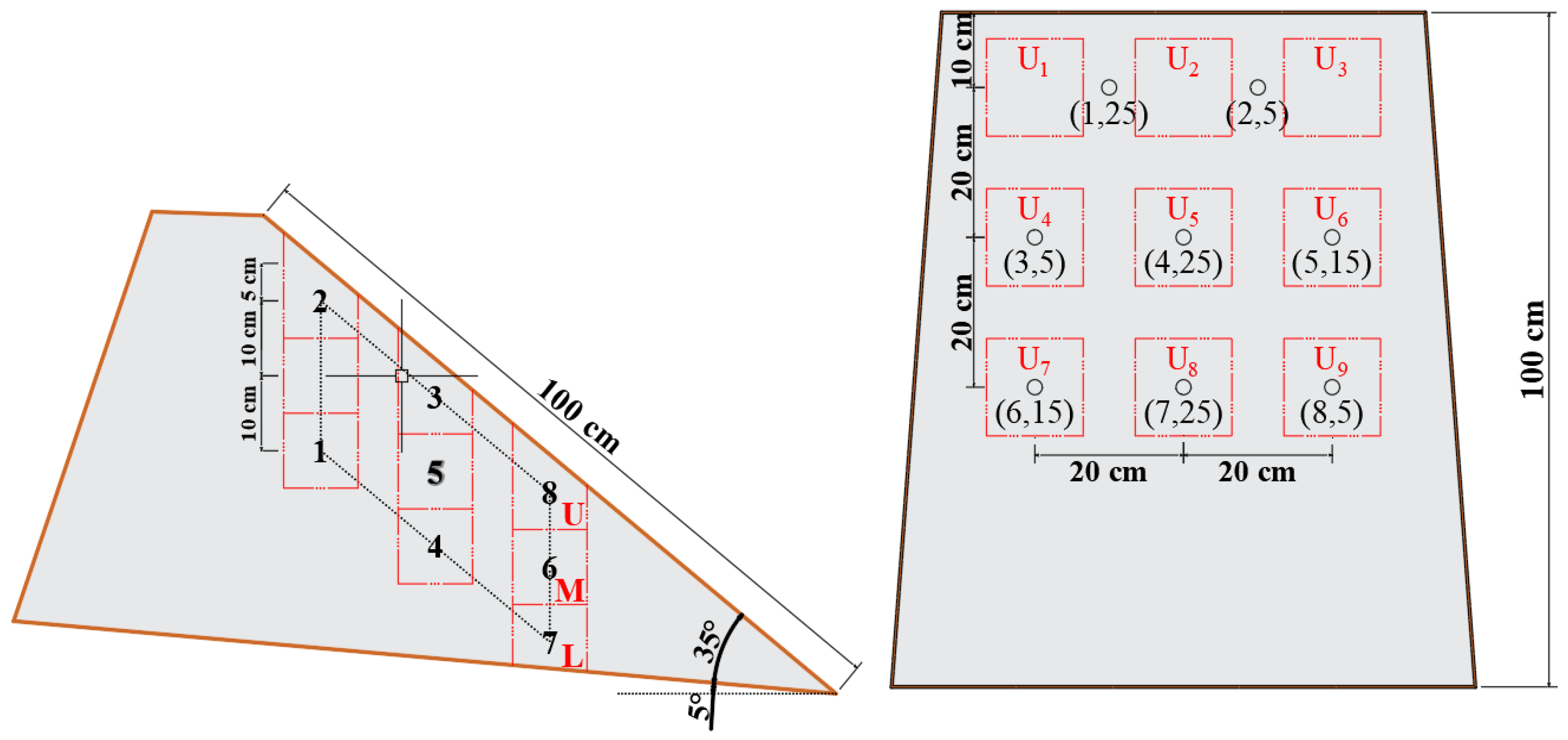
We designed an experimental setup as shown in Figure 4. The experimental samples were placed on a thin steel plate with a thickness of 2 mm, a length of 200 cm, and a width of 90 cm. The soil samples were fully mixed and piled up on top of the steel plate, which was operated by human beings to form a soil pile with a fixed shape. The soil pile is an irregular platform, the slope is isosceles trapezoidal, with the upper bottom being 65 cm and the lower bottom being 80 cm, and the length of the slope is 100 cm, The slope matches the maximum natural slope near the soil sample collection point, and it is 40°. A rainfall nozzle was installed at a vertical height of 130 cm from the top center of the experimental soil sample, and a water pump with rated output power (rated power 100 w) was connected to the other end to ensure uniform and stable rainfall. In addition, a slurry collection device was installed at the toe of the slope to collect the runoff from the slope and the seepage slurry from the slope during rainfall. Pore water pressure and volumetric water content sensors were embedded in the soil. However, in order to understand the associated changes in pore water pressure and volumetric water content at different locations in the slope body, we buried both a water content and a pore water pressure sensor at the same location. Figure 5 shows the location of the sensors buried in the slope body in cross-section and longitudinal sections, a total of eight water content and eight pore water pressure sensors were buried, and the depths of sensors 1–8 were 25 cm, 5 cm, 5 cm, 25 cm, 15 cm, 15 cm, 25 cm, and 5 cm, respectively.
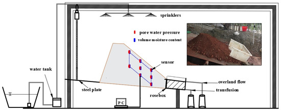
Figure 4.
Figure of soil erosion simulation experimental device.
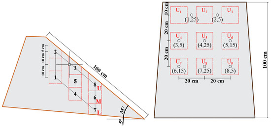
Figure 5.
Schematic diagram of the arrangement and sampling location of pore water pressure and moisture content probes (The red box represents the sampling location, U, M, and L represent the first, second, and third layers, respectively, and U1–U9 represents the sample number; The black small circle and numbers 1–8 represent the pore water pressure and probe position. In “(X, Y)”, X represents the probe number, and Y represents the probe burial depth).
2.3.2. Soil Preparation
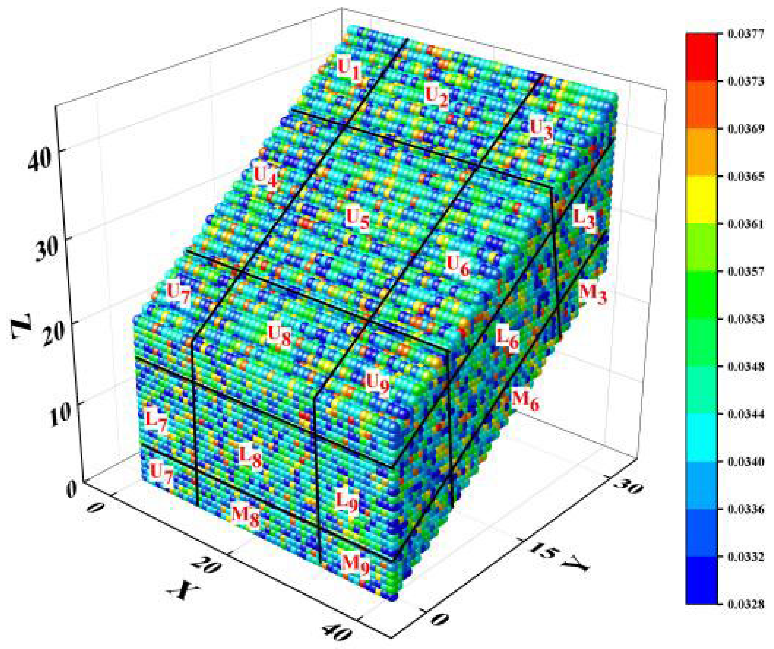
The field-collected laterite was fully stirred, and the stirring process increased the volumetric water content to 20%. The fully mixed samples were piled on top of the steel plate seven times, 10 cm thick each time, and each layer was tamped, so that the dry density of the soil body was as close as possible to the natural state of laterite: the natural dry density of the soil body γd = 1.6 ± 0.1 g/cm3. Finally, the piled-up samples were cut into shapes, as shown in Figure 4. The distribution of fine particles in the soil after stacking is shown in Figure 6 (special attention should be paid to the fact that the distribution of fine particle content is only for the sampling part of the slope, i.e., the position indicated by the blue dashed line in Figure 4). This figure visualizes the distribution of fine particles in the slope body before the experiment, from which it can be seen that the fine particle content of this soil body has a small variation, with a μ value of 0.0353 ± 0.0025. This indicates that the fine particles are uniformly distributed in the soil body.

Figure 6.
The distribution of fine particle content in the initial state of the slope.
2.3.3. Experimental Program and Data Acquisition
- Rainfall intensity and duration
During the rainy season from June to September in the mountainous areas of Sichuan, China, the maximum rainfall intensity always exceeds 100 mm/h, which is the main reason for the formation of geologic disasters such as mudslides and landslides [15,25]. Therefore, we studied the migration characteristics of laterite fine particles under different rainfall intensities. In order to make the rainfall erosion phenomenon more obvious, we selected three rainfall intensities of high, medium, and low to carry out internal erosion simulation experiments, respectively, at 50 mm/h, 100 mm/h, and 150 mm/h. Combined with our experiments, it was found that when the rainfall intensity was 150 mm/h and the rainfall duration was 40 min. This would be very difficult with the phenomenon of a large number of fine particles aggregated within the slope, indicating that, at this time, the internal seepage of the slope is stabilized, and the fine particles have been basically lost. Therefore, in this study, a rainfall duration of 40 min and rainfall intensities of 50 mm/h, 100 mm/h, and 150 mm/h were set to investigate the migration of soil particles.
- 2.
- Sand transport rate, pore water pressure, and water content
In order to obtain the variation of pore water pressure and volumetric water content with rainfall calendar time under different rainfall intensities. Before the experiment, the pore water pressure and water content sensors were buried in a fixed-shape soil pile, as shown in Figure 5, and the rainfall equipment was activated after turning on the pore water pressure and water content collector. Secondly, in this study, to obtain the slope surface runoff and internal seepage obtained at the toe of the slope under different rainfall intensities, the slope surface runoff and internal seepage slurry were collected during the simulated rainfall period, and the rainfall was collected every 2 min after the start of rainfall; each time, it was collected for 20 S. A total of 20 times were collected, taking into consideration of the hysteresis of the internal seepage, so the slope surface runoff was collected first and then the internal seepage slurry was collected. Rainfall was stopped after 40 min and closed after 41.5 min, and the rainfall was stopped after 41.5 min. The pore water pressure and water content equipment were turned off after 41.5 min. The collected slurry was weighed, settled, and separated from the soil particles. The mass of soil particles carried by one milliliter of slurry per minute was converted to the sand transport rate for slope runoff and internal seepage.
- 3.
- Spatial variation in the value of the parameter μ
In order to obtain the soil scale distribution parameter, it is necessary to sample the soil after the end of rainfall, and in order to establish the spatial variation of the parameter μ-value, it is necessary to sample the soil with different rainfall intensities and rainfall calendar times. Therefore, in this paper, the spatial distribution of μ-values of soil at four rainfall moments, 10 min, 20 min, 30 min, and 40 min, is chosen to show the migration of fine particles. Because sampling causes damage to the slope and affects the transport of fine particles in the slope in subsequent rainfall, the experiments with rainfall durations of 10 min, 20 min, 30 min, and 40 min were conducted separately for the same rainfall intensity, with special attention to the fact that, except for the experiment with a 40 min rainfall duration, the experiments with the other durations were sampled only at the end of the rainfall, and the data on the sand transport rate, pore water pressure, and water content were not collected. The data on sand transport rate, pore water pressure, and water content were not collected. After the rainfall stopped for 2 min, the soil was sampled according to the sampling method shown in the red dotted line in Figure 5, with a total of 9 samples per layer, each sampling center spaced 20 cm apart, and a total of three layers per experiment, each layer 10 cm thick. So, for each experiment, a total of 27 samples were taken. Next, we sun-dried the 27 samples and sieved them to obtain the scale distribution parameter μ-value by fitting using Equation (1) and then plotted 3D scatter plots with a large number of parameters obtained via 3D interpolation to spatially visualize the fine particle content data under different rainfall calendars and to form a dynamic pattern of change.
3. Experimental Phenomena
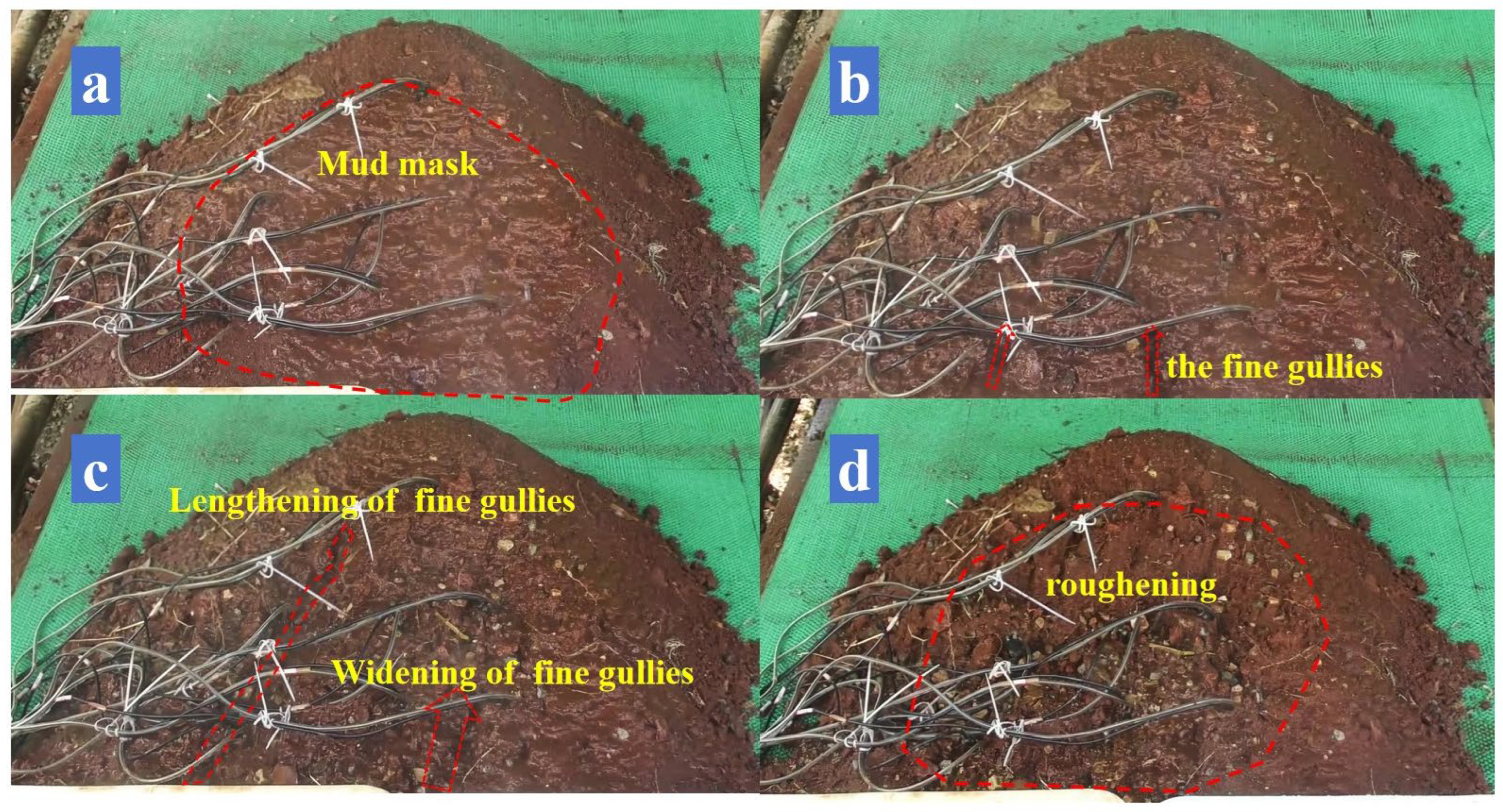
In this experiment, we conducted experiments for different rainfall intensities and found some characteristic phenomena exhibited by slopes when subjected to rainfall erosion. Although the order of appearance of these characteristic phenomena may vary slightly depending on the rainfall intensity, similar phenomena are presented under each rainfall intensity. The specific phenomena can be categorized into the following three stages:
- “Mud mask” stage
This stage occurs at the beginning of the rainfall and the appearance and disappearance of the clay film is significantly earlier as the intensity of rainfall increases. Due to the clay particles in laterite and a very small amount of organic matter with viscous, when the rainfall began, the electrostatic force on the surface of the soil fine particles of the slope surface caused by the bonding of the water film will be fine particles linked, the formation of the “mud film” shown in Figure 7a. The appearance of the “mud film” on the slope surface slows down soil erosion and water flow rate to a certain extent, but as the rainfall continues, the impact of raindrops and the hydrodynamic force is further enhanced, and the fine particles on the slope surface begin to lose. At this time, the slope changes will enter the following second stage:

Figure 7.
Slope changes under rainfall intensity of 100 mm/h: (a) Rainfall time: 02:32; (b) Rainfall time: 05:12; (c) Rainfall time: 32:41; (d) Rainfall time: 40:05.
- Fine channel erosion stage
In this stage, the water flow forms narrow and shallow small gullies on the slope surface, and the fine gullies are first formed at the toe of the slope and gradually develop towards the top of the slope. As shown in Figure 7b,c, with the formation and development of fine gullies, a large amount of fine granular material on the slope surface is carried away, which is also the most serious stage of slope erosion. However, the development of fine watercourses is uncertain due to the random nature of the distribution of large gravels on the slope surface. The presence of large-grained gravel causes the watercourse to curve or widen, causing the watercourse to erode along and around the gravel. Erosion causes the adjacent gravels on the slope surface to collapse at some point, and the tumbling of the gravels and re-erosion of the newly exposed fines cause a sudden increase in the rate of sand transport on the slope. With the loss of fine particles, the gradual exposure of large particles will lead to the following stage:
- Roughening stage
As the rainfall continues, the fine particles are carried away, and the slope gravel (feldspar, quartz, etc.) gradually accumulates to cover the slope surface. As shown in Figure 7d, when the slope surface appears obvious “coarsening phenomenon”, the slope runoff will become clarified, and after the coarsening of the slope surface, the pore size will be more conducive to rainfall infiltration, resulting in increased erosion within the slope.
4. Particle Migration within the Soil
The transport of fine particles under rainfall includes migration and aggregation within the slope, as well as loss that occurs with water. Among them, the transport of fine particles inside the slope will change the spatial structure of soil particles in the slope. The change in spatial structure will have an impact on the stability, permeability, and other physical properties of the slope. Therefore, the spatial heterogeneity of soil particles is portrayed by studying the transport of fine particles inside the slope body under different rainfall conditions as follows.
4.1. Spatial Structure Evolution of Soil Particles
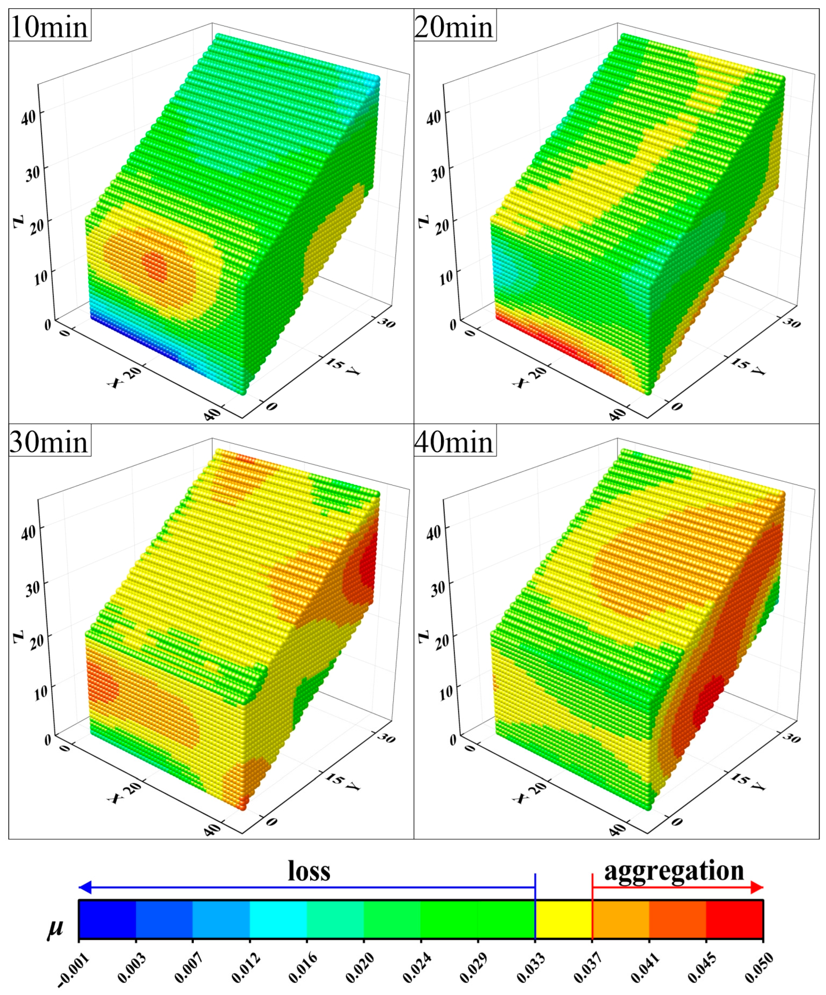
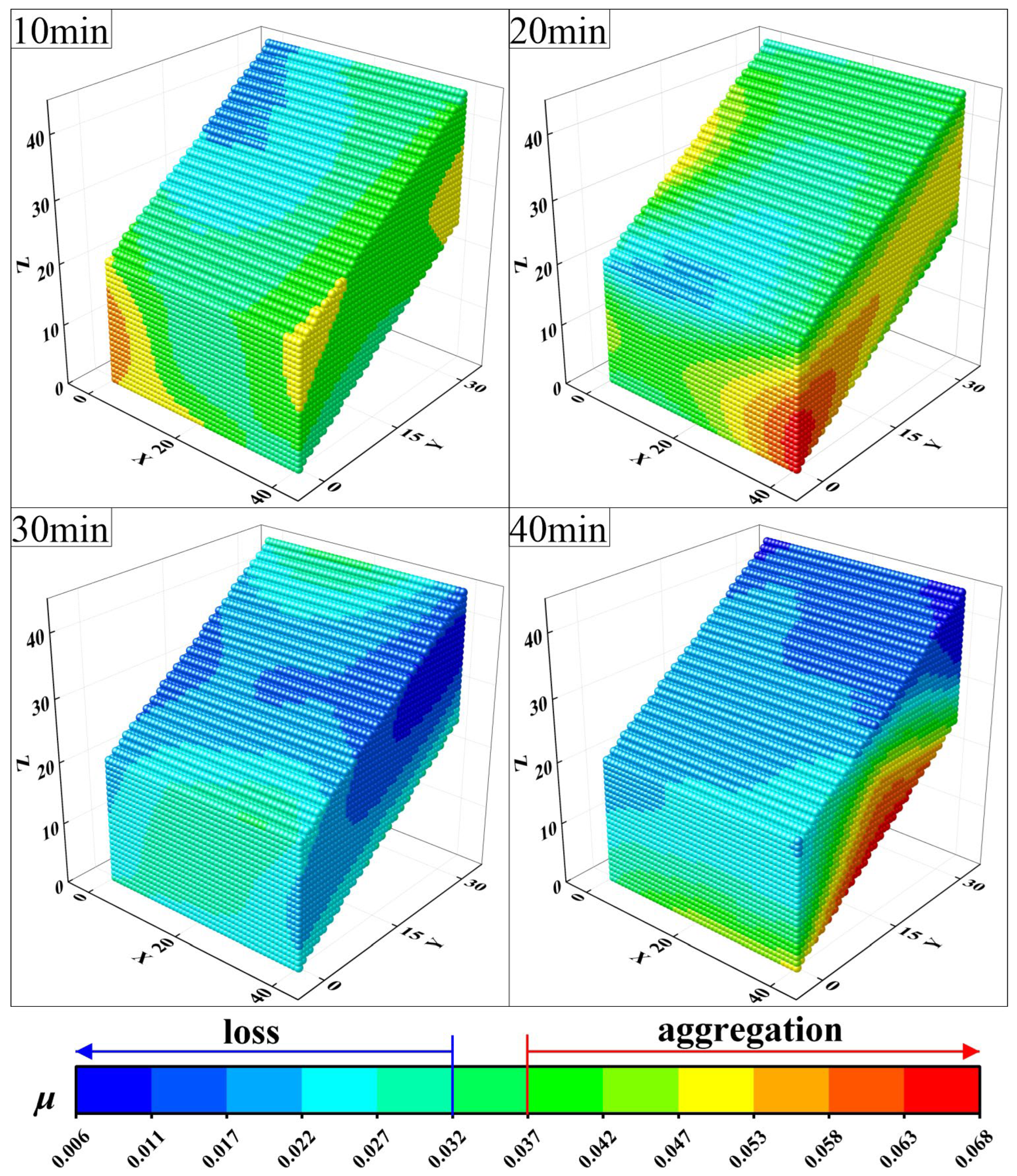
In this section, the spatial structure evolution of the soil parameter μ-value under different rainfall intensities is established by sampling the soil after different rainfall calendar times. In order to clarify the spatial changes of the soil body after rainfall, the slope body corresponded to the sampling locations (i.e., U1~M9) of Figure 6 one by one in establishing the spatial structure evolution of soil particles. And the soil parameter μ = 0.0328~0.0377 under the initial conditions was used as the basis for the division when the value of μ less than 0.0328 was considered as the loss of fine particles and the value of μ greater than 0.0377 was considered as the accumulation of fine particles. Such a division helps to further study the transport of fine particles in the soil body and their effects on the soil’s physical properties. However, considering the different ranges of fine particle characterization parameters under different rainfall intensities, the division of fine particle loss and accumulation is slightly different, and the specific division is based on the color scale card under the spatial structure evolution map of soil parameter μ value.
Under rainfall infiltration conditions, the migration and aggregation of fine particles within a slope are influenced by the randomness and inhomogeneity of the pore distribution of the soil. Therefore, the aggregation and loss of fine particles within the slope occur randomly during the structural evolution of the soil particles. It is because of the existence of this randomness that the migration of fine particles within the slope is always difficult to capture. Therefore, this paper establishes the spatial structure evolution of the soil parameter μ value under different rainfall intensities via the soil scale distribution parameter, and the spatial structure evolution of the soil particles of this lateritic soil is shown in Figure 8, Figure 9 and Figure 10. Through the observation of different spatial structure evolution, it was found that obvious fine particle aggregation and loss phenomena were observed at the position of the toe of the slope in the spatial structure distribution maps of the slope body at the moments of 10 min, 20 min and 30 min in Figure 8; 10 min and 20 min in Figure 9; and 20 min and 30 min in Figure 10. This indicates that under rainfall infiltration, fine particles always accumulate at the toe of the slope and are lost there. In addition, the effects of rainfall duration and rainfall intensity on the migration and accumulation characteristics of fine particles are both controlling factors [27], where it is feasible to understand the early stage of rainfall as a comprehensive consideration of low rainfall intensity or short rainfall duration. At the early stage of rainfall, the aggregation of fine particles inside the slope in Figure 8 for 20 min and 40 min and in Figure 9 for 20 min is always in the form of banded downslope aggregation. With the increase in rainfall intensity or the extension of rainfall calendar time, the fine particles of the slope are mostly aggregated in the form of clusters at the toe of the slope or in the slope body. This suggests that in the early stage of rainfall, the fine particles first dominate vertical downward migration, leading to the aggregation of fine particles to deeper depths, forming a strip-like distribution downslope; this strip-like aggregation of fine particles is similar to a layer of water film with good lubricity found by previous scholars in their experiments and that the slope body will likely undergo shallow damage along this layer [9,28]. Subsequently, the migration direction will have both vertical downward and downward along the slope due to the hydraulic gradient, after which the fine particles will gradually converge or be lost towards the toe of the slope.
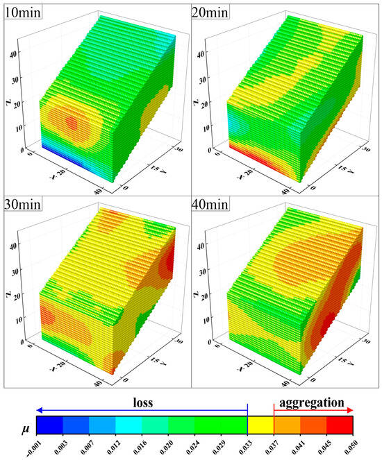
Figure 8.
Evolution of spatial structure of soil particles (50 mm/h).

Figure 9.
Evolution of spatial structure of soil particles (100 mm/h).
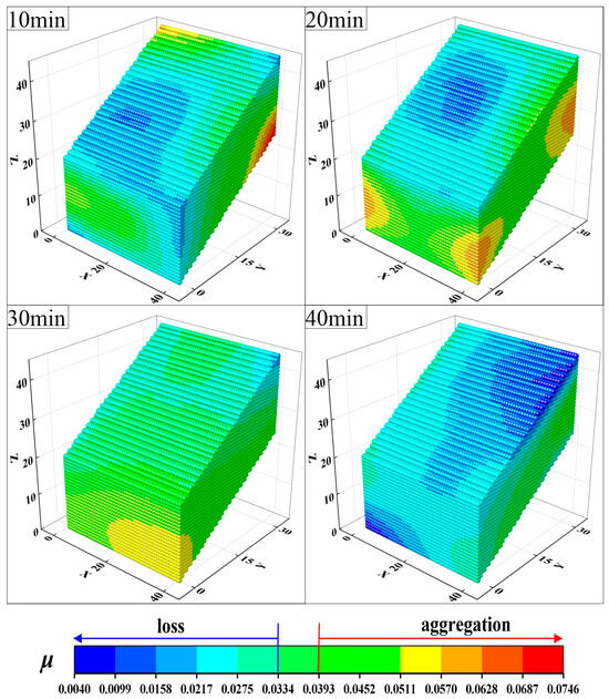
Figure 10.
Evolution of spatial structure of soil particles (150 mm/h).
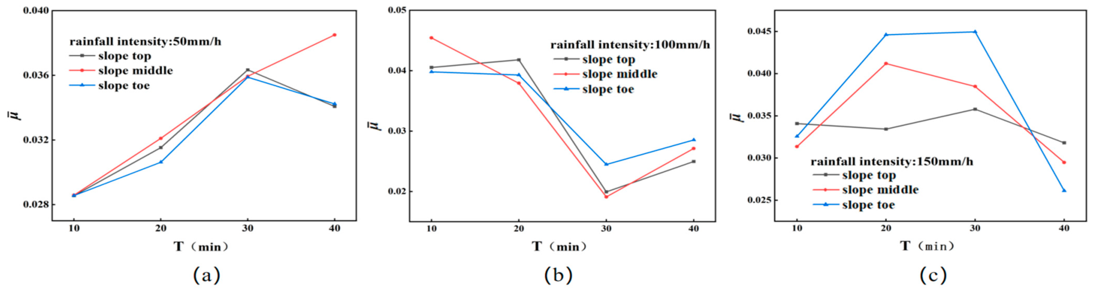
The occurrence of fine particle aggregation and loss shows random distribution characteristics during the evolution of the spatial structure of soil particles. However, by observing the changes in the spatial structure of soil particles, it is possible to speculate on the origin and approximate migration direction of fine particles and to observe the trends and migration of fine particles. For example, the gradual increase in the fine particle content at a certain location after rainfall indicates that the transport of fine particles may be blocked by the minimum pore size of the soil at this location; on the contrary, the gradual decrease may be the loss of fine particles, which indicates that the pore connectivity at this location is good and the permeability of the soil is strong, which is conducive to the transport of fine particles. In order to more accurately describe the migration of fine particles at various locations in the slope body. Figure 1 represents the changes in the fine particle migration at different locations of the lateritic soil slope under different rainfall intensities. Under the same rainfall intensity, the top of the slope, the middle of the slope, and the toe of the slope are under the same hydrodynamic conditions, so the changes in the fine particles in different locations are roughly the same, but with the increase in the rainfall intensity, the content of fine particles in the same location varies greatly and the difference is obvious. In addition, when the rainfall intensity was 50 mm/h, gradually increased, and the content of fine particles in the slope was the highest at 40 min, indicating that when the rainfall intensity was small, fine particles were more likely to gather in the slope. At 100 mm/h, decreased, but the toe of the slope contained the most fine particles, indicating that the fine particles in the slope body gradually gathered at the toe of the slope. At 150 mm/h, decreased after 20 min, but the toe of the slope contained the least amount of fine particles, indicating that the fine particles of the slope body had been lost in large quantities. Therefore, the increase in rainfall intensity intensified the migration of fine particles in the slope body and their loss from the slope body.
4.2. Soil Pore Water Pressure and Water Content
The transportation of fine particles in the slope body changes the spatial structure of the soil body, and the change in spatial structure results in differences in volumetric water content and pore water pressure at different locations of the soil body under the same hydrodynamic conditions. Figure 11 shows the variation of volumetric water content and pore water pressure with time at different locations in the slope body under different rainfall intensities.
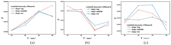
Figure 11.
Variation of fine particle content at different locations of the slope body under different rainfall conditions. (a–c) represent rainfall intensities of 50 mm/h, 100 mm/h, and 150 mm/h, respectively. represents the average value of all fine particle content parameters at different slope locations, with the top, middle, and toe of the slope being the upper, middle, and lower sections of the slope body, respectively; the top of the slope includes U1~U3, L1~L3, and M1~M3, and the middle and toe of the slope are in the same order).
4.2.1. Change in Volumetric Moisture Content
Under the condition of rainfall infiltration on soil slopes, the volumetric water content of the soil body tends to increase slowly at first, then increase rapidly, and remain stable after reaching the maximum volumetric water content. Comparing the volumetric water content at different locations on the slope, we find that the deeper the volumetric water content sensor is buried and the closer it is to the foot of the slope, the higher the maximum water content the soil can reach, and the more stable it is over time. This phenomenon occurs, on the one hand, because the fine particles have a larger specific surface area than the coarse particles, which can adsorb more free water, and on the other hand, the aggregation of fine particles leads to a change in the spatial structure of the slope body, the pore space decreases, and the permeability becomes worse, which makes it difficult for the water to flow and be discharged. Therefore, in the process of rainfall, the migration of fine particles changes the local fine particle content of the slope body, which directly leads to a slight difference in the water content at different locations of the slope body.
4.2.2. Pore Water Pressure Change
Compared with the volumetric water content, the change in pore water pressure is much more complicated, but it is not lawless. On the one hand, the changing trend of the pore water pressure in different slope locations is basically the same, the pore water pressure at the top of the slope is relatively stable; in the middle of the slope, there is a slowly rising trend, and the foot of the slope is stable after rising, but the pore water pressure at the foot of the slope is greater. After the rainfall starts, with the rainfall infiltration, the foot of the slope not only accepts direct infiltration from rainfall but also accepts the seepage recharge from the upper slope. Therefore, the foot of the slope often gathers more water, so the high pore water pressure always appears at the foot of the slope. At the same time, it also shows again that rainfall infiltration is always converging to the foot of the slope, and the fine particles of soil will also infiltrate the foot of the slope with the water; on the other hand, with the increase in rainfall intensity, the pore water pressure starts to rise in advance and reaches the maximum value after maintaining the stability of the curve is located in the top of the slope tendency to develop. The reason for this phenomenon is that after rainfall infiltration, the soil pore space from the foot of the slope to the top of the slope position will be gradually filled with water. This form of accumulation will continue until the foot of the slope forms a stable seepage outlet or the slope body is damaged, resulting in the discharge of water from the pore space. Otherwise, the pore water pressure of the slope body continues to increase to a maximum value and then remains stable.
4.2.3. Dynamic Change Mechanism Analysis
In the process of rainfall infiltration, the migration and aggregation of fine particles in the soil body will change the particle size distribution of the soil body, thus causing changes in the pore water pressure and volumetric water content of the soil body. Therefore, the changes in pore water pressure and water content in the slope body can be analyzed from the aggregation and loss of fine particles. The spatial structure evolution of soil particles provides information on the migration and aggregation of fine particles in the slope body. Figure 12 provides the changes in pore water pressure and water content. In order to better link the migration of fine particles with the changes in pore water pressure and water content, the locations of sudden changes in volumetric water content in the soil body were selected for the analysis of the mechanism of dynamic changes in pore water pressure and water content, i.e., the location of sensor No. 3 of the slope body at a rainfall intensity of 100 mm/h and the location of sensor No. 2 of the slope body at a rainfall intensity of 150 mm/h.
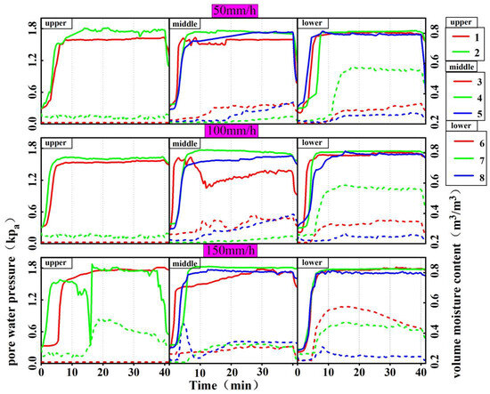
Figure 12.
Changes in pore water pressure and volumetric water content with rainfall (the dashed line represents pore water pressure, while the solid line represents volumetric water content).
In Figure 9, the spatial structure map of the soil after 10 min of rainfall shows fine particle loss at the location of sensor No. 3 and aggregation at 20 min. The volumetric water content at this location suddenly changed, decreased at 7 min, and increased again at 11 min, while the pore water pressure fluctuated after 2–3 min of volumetric water content change. Therefore, combining the changes in the fine particle content, volumetric water content, and pore water pressure in position 3, when the rainfall intensity is 100.32 mm/h, the slope is in the infiltration stage from 0–7 min, so the volumetric water content and pore water pressure rise in position 3, but the pore water pressure rises slowly. At 7 min, the volumetric water content decreases suddenly, which indicates that there is a sudden loss of fine particles at this point in time in position 3, and the sudden loss of fine particles. The sudden loss of fine particles inevitably led to the increase in the pore space of the soil body here. Although the pore space increased, it took time for the pore space to be filled with water, so the pore water pressure rose again only after 2–3 min. As the rainfall continues, the seepage within the slope does not stop, so the pores within the slope will be supplemented by fine particles, and even the expansion of the pore space leads to the collapse of large particles, so the volumetric water content decreases to a certain extent and will rise again, and pore water pressure fluctuates due to the sudden change in the pore space. Therefore, the sudden loss of fine particles at 7 min and the slow accumulation after 12 min make position No. 3 of the fine particle content distribution map after 10 min of rainfall show the loss of fine particles and the aggregation of fine particles at 20 min.
When the rainfall intensity was 150 mm/h, the volumetric water content at the No. 2 sensor location of the slope body suddenly decreased at 12 min, followed by a sharp increase, while the pore water pressure went through a process of sudden increase and then gradual decrease. As shown in Figure 10, the soil spatial structure map of the soil body after 10 min rainfall of the No. 2 sensor location shows the aggregation of fine particles, and 20 min shows the loss. It indicates the loss of fine particles in 10–20 min at the No. 2 sensor location. And the sudden decrease of water content after 12 min indicates that the sudden loss of fine particles occurred after 12 min of rainfall, which led to the decrease in water content and the increase in pore space in the soil. With the continuous infiltration of rainfall, the pore space was gradually filled with water, resulting in an increase in pore water pressure. However, at the same time, the fine particles entering the pore space also filled the pore space, causing the volumetric water content to increase again, while the pore water pressure gradually decreased after reaching a certain level.
4.3. Spatial Structure Evolution of Soil Particles
The loss of fine particles from soil slopes consists of two aspects: one is the sediment mixture carried away by rainfall erosion of the slope surface, and the other is the migration of fine particles within the soil mass and their eventual loss at the toe of the slope.
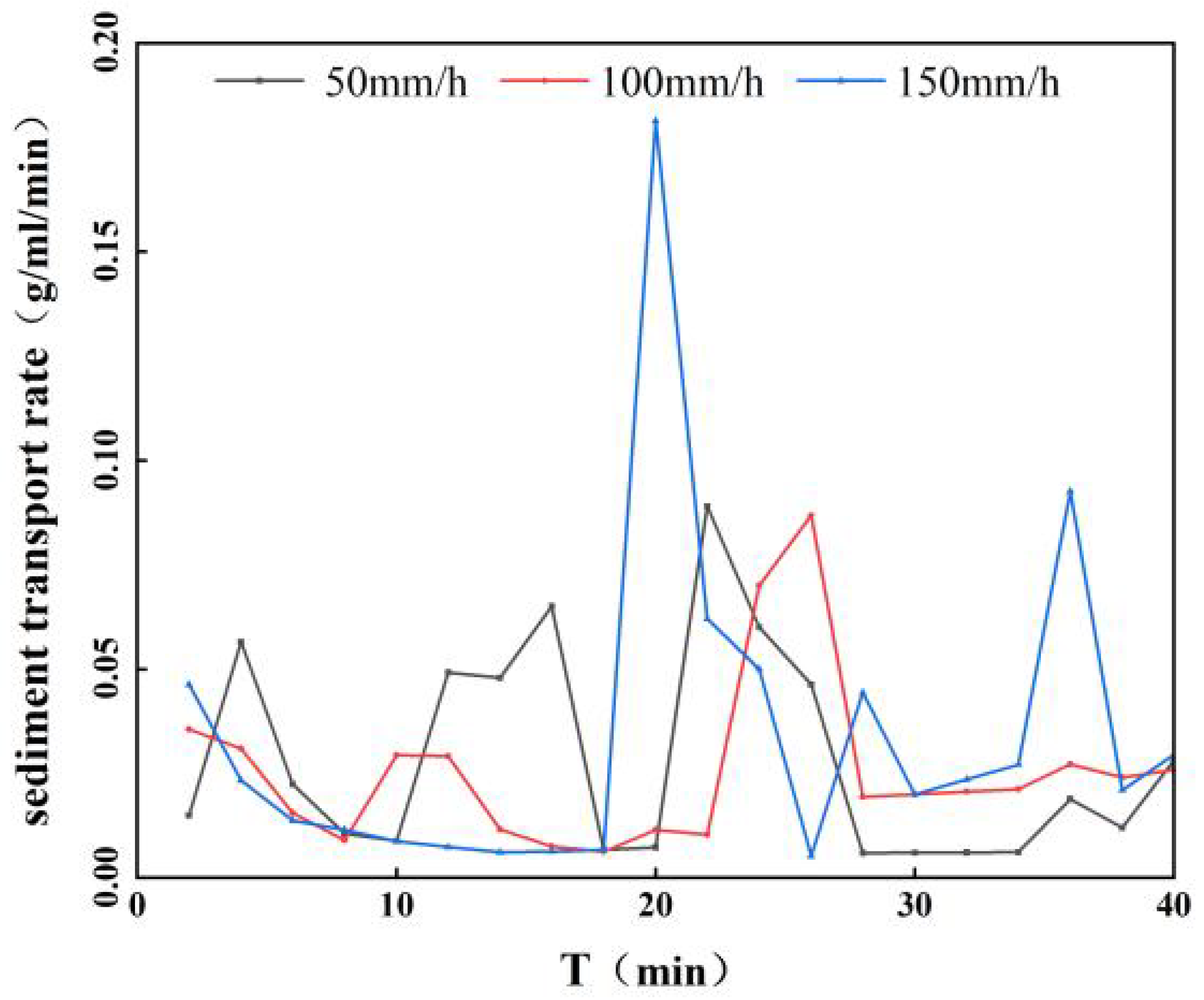
During rainfall, fine particles on soil slopes are washed by rainwater and flow along the slope surface, forming slope erosion. On the slope surface, due to the random distribution of larger gravels on the slope surface, as well as the formation of gullies, and the appearance of small surface failures all show strong randomness, so the sand transport rate of the sediment mixture on the slope surface with the rainfall ephemeral time shows strong randomness, as shown in Figure 13. This also shows the changes in the sand transport rate of the runoff on the slope surface with the rainfall time.
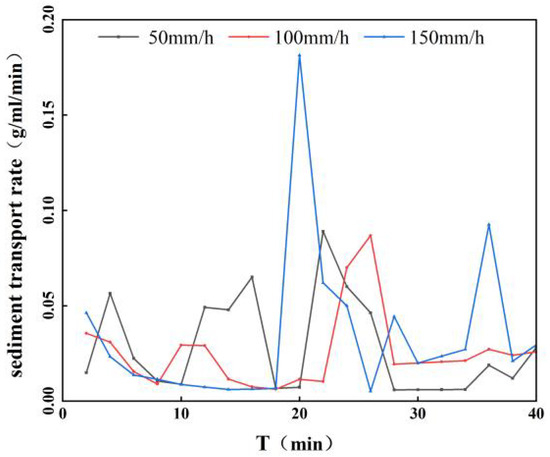
Figure 13.
The variation of sand transport rate of slope runoff with rainfall time.
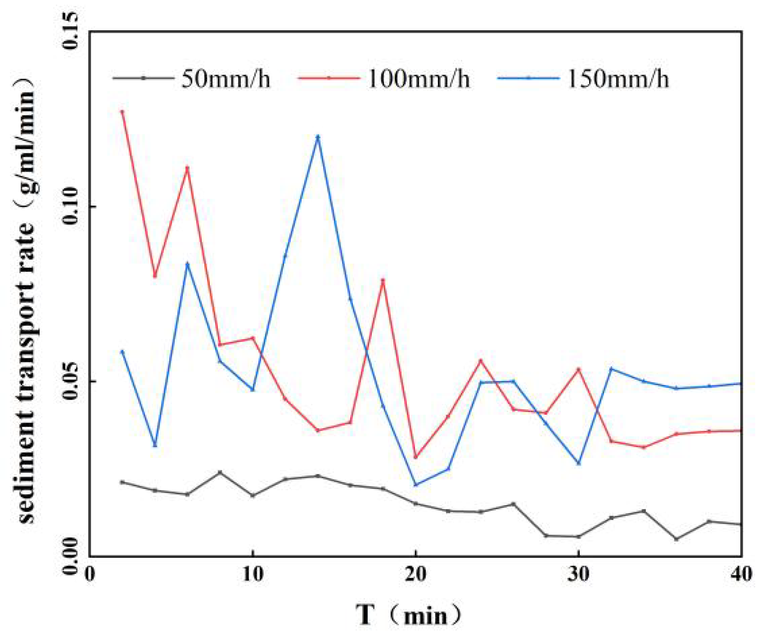
For the loss of fine particles within the slope, limited by the minimum pore size of the soil pores, the fine particles usually block at the minimum pore size, leading to an increase in the localized fine particle content of the slope. However, with further rainfall infiltration, the hydrodynamic forces gradually increase, and the pore water pressure further increases, which will break through this blockage and lead to the re-migration of fine particles, thus leading to the loss of fine particles. This process of hydrodynamic changes can cause alternating phenomena of blockage and loss of fine particles. In addition, the randomness and inhomogeneity of soil pore distribution will also have a significant effect on the sand transport rate of the seepage slurry within the slope. Therefore, under the same rainfall conditions, the sand transport rate of the seepage slurry inside the slope body shows a strong randomness. As shown in Figure 14, the variation in sand transport rate of internal seepage with time is demonstrated. Even though the sand transport rate of internal seepage shows strong randomness, the overall sand transport rate gradually decreases and stabilizes. When the rainfall intensity is low (rainfall intensity: 50 mm/h), the change in the sand transport rate of internal seepage is relatively stable and small, while the change in the sand transport rate increases with the increase in rainfall intensity.
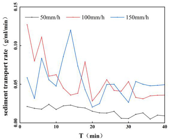
Figure 14.
The variation of internal seepage sand transport rate with rainfall time.
4.4. Fine Particle Migration Mechanism
Under the action of rainfall, fine particles within the soil are transported between the large granular skeleton via percolation. This transport consists of two aspects: one is the transport of fine particles between the large granular skeleton, and the other is the loss that occurs with water. Inside the slope, fine particles tend to accumulate at the smallest pore size, leading to changes in pore water pressure and water content, which, in turn, affects the stability of the slope.
In the rainfall process, part of the fine particles in the early stage of rainfall are lost in the form of slope runoff, and the other part is infiltrated with water. This part of the infiltration of fine particles in the early part of the vertical infiltration will form a layer of fine particles in the shallow layer of the slope body aggregation band. The fine particle aggregation band of low shear strength may cause shallow damage to the slope body. For continued rainfall, i.e., fine particles in the slope body continue to migrate, at this time, the migration of fine particles via the unevenness of the pore space in the slope body and the randomness of the influence of the fine particles has become complex. But, in general, the fine particles migrate toward the foot of the slope. This also leads to an increase in the content of fine particles at the foot of the slope; the greater the content of fine particles, the larger the specific surface area of soil particles. Therefore, the water content is greater. The increase in the content of fine particles at the foot of the slope leads to changes in the foot of the slope spatial structure and pore size, reduced soil permeability, and impeded water seepage, resulting in pore water pressure increases. Therefore, the accumulation of fine particles to form a water film with good lubrication and the increase in the pore water pressure at the foot of the slope may lead to the destruction of the slope from the foot of the slope.
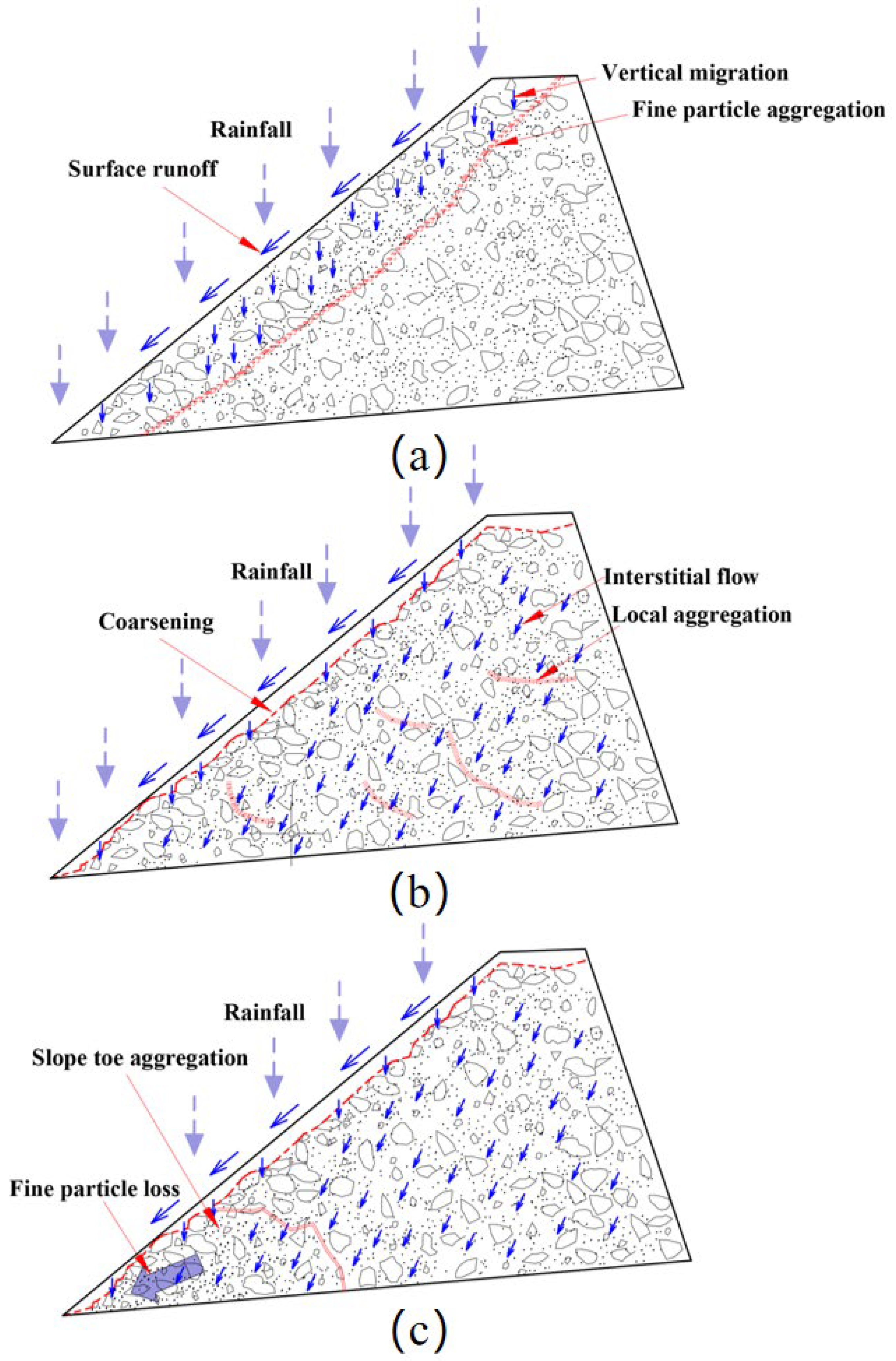
Inside the slope, the fine particles of the soil are transported via seepage through the pore space formed by the coarse skeleton, which is controlled by the connectivity and heterogeneity of the pore space. When the fine particles are transported to the smallest aperture and gathered here, but as the content of fine particles increases, the hydrodynamic strengthening of the smallest aperture will be opened, and the aggregated seepage carries the fine particles to continue to migrate as a “dam bursting” type, resulting in a precipitous reduction in the water content of the place. The expansion of the channel or the loss of fine particles will inevitably lead to the pore size and then the seepage to fill the pore so that the pore water pressure gradually increases. It should be noted that the increase in this type of pore water pressure has a certain lag because seepage to fill the pore needs some time. In addition, such temporarily opened seepage channels are unstable and may collapse during sudden changes in water content, which will lead to a more complex change in pore water pressure, but the overall growth trend is maintained because the loss of fine particles inevitably leads to an increase in pore size. The migration process of fine particles within the slope is shown in Figure 15.
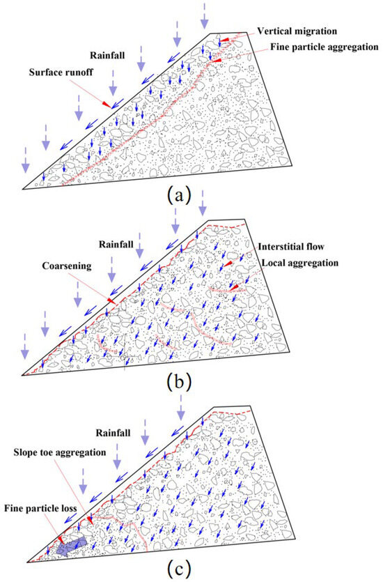
Figure 15.
Schematic diagram of fine particle migration: (a) in the early stage of rainfall, fine particles migrate vertically; (b) during the middle period of rainfall, fine particles randomly aggregate within the slope, resulting in the phenomenon of “coarsening” of the slope surface; (c) in the later stage of rainfall, fine particles accumulate at the foot of the slope and are lost in large quantities.
5. Effects of Fine Particle Migration on Slope Stability
Both the accumulation of fines within the slope and the loss of fines at the foot of the slope can change the structural characteristics of the soil, thereby affecting the stability of the slope. Under rainfall infiltration, vertical infiltration in the early stages results in the formation of a “lubricating surface” of low shear strength within the slope, along which shallow sliding may occur. Subsequently, the fine particles continue to migrate inside the slope at this time, i.e., the migration of fine particles via vertical infiltration, but also along the slope to the downward infiltration, albeit from the unevenness of the pore space and the randomness of the impact, with the fine particles migrating to the foot of the slope to the general aggregation. The content of fine particles at the foot of the slope is generally higher than that at other locations of the slope, and the aggregation of fine particles increases the compactness of the soil body, the permeability of the foot of the slope is weakened, the seepage water is not easy to be discharged, and the water content becomes higher, so the pore water pressure increases, which affects the stability of the slope body, and this is the main reason that the damage of the slope body always starts from the foot of the slope. In addition, the aggregation of fine particles at the smallest aperture inside the slope also affects the stability of the slope. When the migration of fine particles meets the minimum aperture, although the increase in fine particles can make the soil compactness increase and, to a certain extent, make the slope stable, but as rainfall continues, the infiltration of the further development of hydrodynamic enhancement will break the minimum aperture limitation. The fine particles of the “dam-busting” loss lead to the pore space increase, and the pore space is easy to collapse, thus making it easy to destroy the slope. The pore space is easy to collapses, thus damaging the slope, even if the stability of the pore space is not damaged, in the seepage water replenishment of the pore space; the pore space water pressure increases when the stability of the slope also has an impact. Secondly, the stabilized pore space provides a good transportation channel for fine particles, which will exacerbate the loss of fine particles from the soil, making the slope body become loose and the mechanical properties deteriorate, thus triggering the destruction of the slope body.
6. Conclusions
In this paper, based on the parameters used to characterize the fine particle content of the soil body obtained from the soil particle scale distribution formula, the distribution map of the fine particle content of the slope body under different rainfall conditions was drawn, and the fine particle dynamic model was established. In addition, the fine particle migration pattern of laterite slopes was investigated by combining the changes in pore water pressure and water content at different locations of the slopes under rainfall conditions. The following main conclusions were obtained:
- Under rainfall conditions, the erosion process of laterite slopes can be roughly divided into three stages: the “mud film stage”, the fine-groove erosion stage, and the slope “coarsening” stage.
- In the process of rainfall infiltration, the migration and aggregation of fine particles are influenced by the randomness and inhomogeneity of the pore distribution of the soil body, thus showing a strong randomness. As a result, the phenomenon of aggregation and loss of fine particles within the slope appears to be obviously random.
- The failure of the slope typically initiates at the toe. Influenced by rainfall erosion, the internal migration of fine particles within the slope ultimately aggregates at the toe of the slope, resulting in an increase in pore water pressure and moisture content at the toe. This, in turn, leads to the slope’s failure.
- In the early stage of rainfall, the fine particles in the slope are mainly infiltrated in the vertical direction, and the fine particles are mostly aggregated in the form of bands. Afterward, with the continuous infiltration of rainfall, the seepage gradually becomes both vertically downward and slopes downward. Therefore, the fine particles always gather at the foot of the slope, resulting in a higher water content at the foot of the slope and an increase in pore water pressure, leading to the destruction of the slope from the foot of the slope.
Author Contributions
Conceptualization, D.C.; methodology, D.C.; validation, D.C. and Y.L.; formal analysis, D.C. and Y.L.; investigation, D.C., T.Y. and Q.L.; resources, F.A.; data curation, D.C.; writing—original draft preparation, D.C. and Y.L.; writing—review and editing, D.C., F.A., T.Y. and Y.L.; visualization, T.Y. and Y.L.; supervision, F.A., T.Y., Q.L. and Y.L.; project administration, F.A.; funding acquisition, F.A. All authors have read and agreed to the published version of the manuscript.
Funding
This research was funded by the National Natural Science Foundation of China, Grant No. 42267020.
Institutional Review Board Statement
Not applicable.
Informed Consent Statement
Not applicable.
Data Availability Statement
The data presented in this study can be obtained by contacting the corresponding author. Due to privacy restrictions, these data are not publicly accessible.
Conflicts of Interest
Author Taiqiang Yang was employed by the company Power China Kunming Engineering Co., Ltd. The remaining authors declare that the research was conducted in the absence of any commercial or financial relationships that could be construed as a potential conflict of interest.
References
- Yuan, Y.; Wang, R. Characteristics of particle size loss of fine particles in agricultural soils under wind erosion and its effect on soil properties. J. Soil Water Conserv. 2018, 32, 104–109+119. [Google Scholar]
- Kaitna, R.; Dietrich, W.E. Surface slopes, velocity profiles and fluid pressure in coarse-grained debris flows saturated with water and mud. J. Fluid Mech. 2014, 741, 377–403. [Google Scholar] [CrossRef]
- Iverson, R.M.; Logan, M. The perfect debris flow? Aggregated results from 28 large-scale experiments. J. Geophys. Res. 2010, 115, F03005. [Google Scholar] [CrossRef]
- Major, J.J.; Iverson, R.M. Debris-flow deposition; effects of pore-fluid pressure and friction concentrated at flow margins. Geol. Soc. Am. Bull. 1999, 111, 1424–1434. [Google Scholar] [CrossRef]
- Guo, X.; Li, Y. Discontinuous slope failures and pore-water pressure variation. J. Mt. Sci. 2016, 13, 116–125. [Google Scholar] [CrossRef]
- Shen, S.; Xi, C. Water-holding properties of major soils in Huaibei and their relationship with particle composition. J. Soil Sci. 1990, 1, 34–42. [Google Scholar]
- Yang, X.; Wang, Y. Study on the surface particle distribution characteristics of silt with different moisture content. Arab. J. Geosci. 2020, 13, 1. [Google Scholar] [CrossRef]
- Skempton, A.W. Residual strength of clays in landslides, folded strata and the laboratory. Géotechnique 1985, 35, 3–18. [Google Scholar] [CrossRef]
- Guo, C.; Cui, P. A review of the study on the migration law of fine particles in wide-graded weakly consolidated soils. J. Mt. Geol. 2017, 35, 179–186. [Google Scholar]
- Wang, B.; Chen, L. Critical hydraulic gradient and fine particle migration of sand under upward seepage flow. Sci. Rep. 2022, 12, 14440. [Google Scholar] [CrossRef]
- Yerro, A.; Rohe, A. Modelling Internal Erosion with the Material Point Method. Procedia Eng. 2017, 175, 365–372. [Google Scholar] [CrossRef]
- Sibille, L.; Marot, D. A description of internal erosion by suffusion and induced settlements on cohesionless granular matter. Acta Geotech. 2015, 10, 735–748. [Google Scholar] [CrossRef]
- Deng, Z.; Chen, X.; Jin, W.; Wang, G. Effect of Gradation Characteristics and Particle Morphology on Internal Erosion of Sandy Gravels: A Large-Scale Experimental Study. Water 2023, 15, 2660. [Google Scholar] [CrossRef]
- Xu, J.; Shang, Y. Influence of infiltration characteristics of gravel soil on landslide stability. J. Rock Mech. Eng. 2006, 11, 2264–2271. [Google Scholar]
- Cui, Y.; Zhou, X.; Guo, C. Experimental study on the moving characteristics of fine grains in wide grading unconsolidated soil under heavy rainfall. J. Mt. Sci. 2017, 14, 417–431. [Google Scholar] [CrossRef]
- Wang, B.; Li, Y. Characteristics of fine particle migration of soil under rainfall and its effect on collapse. Eng. Sci. Technol. 2017, 49 (Suppl. S2), 40–50. [Google Scholar]
- Jiao, B.; Lu, X. Fine particle transport and effects in rainfall landslides on soil. J. Undergr. Space Eng. 2005, 19 (Suppl. S1), 36–38. [Google Scholar]
- Dai, D.; Qi, X. Study on mudslide and ecological status analysis in Xiaojiang Basin, Yunnan Province. Sci. Technol. Innov. Appl. 2012, 5, 23–24. [Google Scholar]
- Li, Y.; Huang, C.; Wang, B.; Tian, X.; Liu, J. A unified expression for grain size distribution of soils. Geoderma 2017, 288, 105–119. [Google Scholar]
- Li, Y.; Xie, J. Scalar distribution of mudslide particles. J. Sichuan Univ. Eng. Sci. Ed. 2013, 45, 1–7. [Google Scholar]
- Li, Y.; Zhou, X.; Su, P.; Kong, Y.; Liu, J. A scaling distribution for grain composition of debris flow. Geomorphology 2013, 192, 30–42. [Google Scholar]
- Zhang, J.; Li, Y.; Liu, D.; Jiang, N.; Yang, T.; Guo, X.; Yao, Y. The probability-based granular field of vegetated soils. Earth Surf. Proc. Land 2022, 47, 3100–3116. [Google Scholar] [CrossRef]
- Zhang, J.; Li, Y.; Yang, T.; Liu, D.; Liu, X.; Jiang, N. Spatiotemporal variation of moisture in rooted-soil. Catena 2021, 200, 105144. [Google Scholar] [CrossRef]
- Yang, T. Dynamic Effects of Mudslide Particle Distribution. Ph.D. Thesis, University of Chinese Academy of Sciences, Beijing, China, 2021. [Google Scholar]
- Guo, X.; Cui, P. Spatial features of debris flows and their rainfall thresholds in the Wenchuan earthquake-affected area. Landslides 2016, 13, 1215–1229. [Google Scholar] [CrossRef]
- Wang, B. Characterization of Mudslide Material Evolution. Master’s Thesis, University of Chinese Academy of Sciences, Beijing, China, 2015. [Google Scholar]
- Zhou, X.; Cui, P. Experimental study of soil fine particle migration and accumulation flume based on orthogonal design. J. Sichuan Univ. Eng. Sci. 2012, 44 (Suppl. S1), 83–88+103. [Google Scholar]
- Zhuang, J.; Peng, J.; Zhu, Y.; Leng, Y.; Zhu, X.; Huang, W. The internal erosion process and effects of undisturbed loess due to water infiltration. Landslides 2021, 18, 629–638. [Google Scholar] [CrossRef]


Disclaimer/Publisher’s Note: The statements, opinions and data contained in all publications are solely those of the individual author(s) and contributor(s) and not of MDPI and/or the editor(s). MDPI and/or the editor(s) disclaim responsibility for any injury to people or property resulting from any ideas, methods, instructions or products referred to in the content. |
© 2023 by the authors. Licensee MDPI, Basel, Switzerland. This article is an open access article distributed under the terms and conditions of the Creative Commons Attribution (CC BY) license (https://creativecommons.org/licenses/by/4.0/).