
GIS Approach for Expressing Structural Landforms: Forms, Elements, and Relationships

 , ,
, ,
Abstract
:1. Introduction
2. GIS Approach for Expressing Structural Landforms
- (1)
- Combined with the surface morphological characteristics, structural landforms are abstracted into various elements, and the characteristics and relationships of these elements are analyzed.
- (2)
- Spatial objects and topological rules of structural landforms are designed.
- (3)
- The structural landform markup language (SLML) expressions of structural landforms are as follows: forms, elements, and relationships.
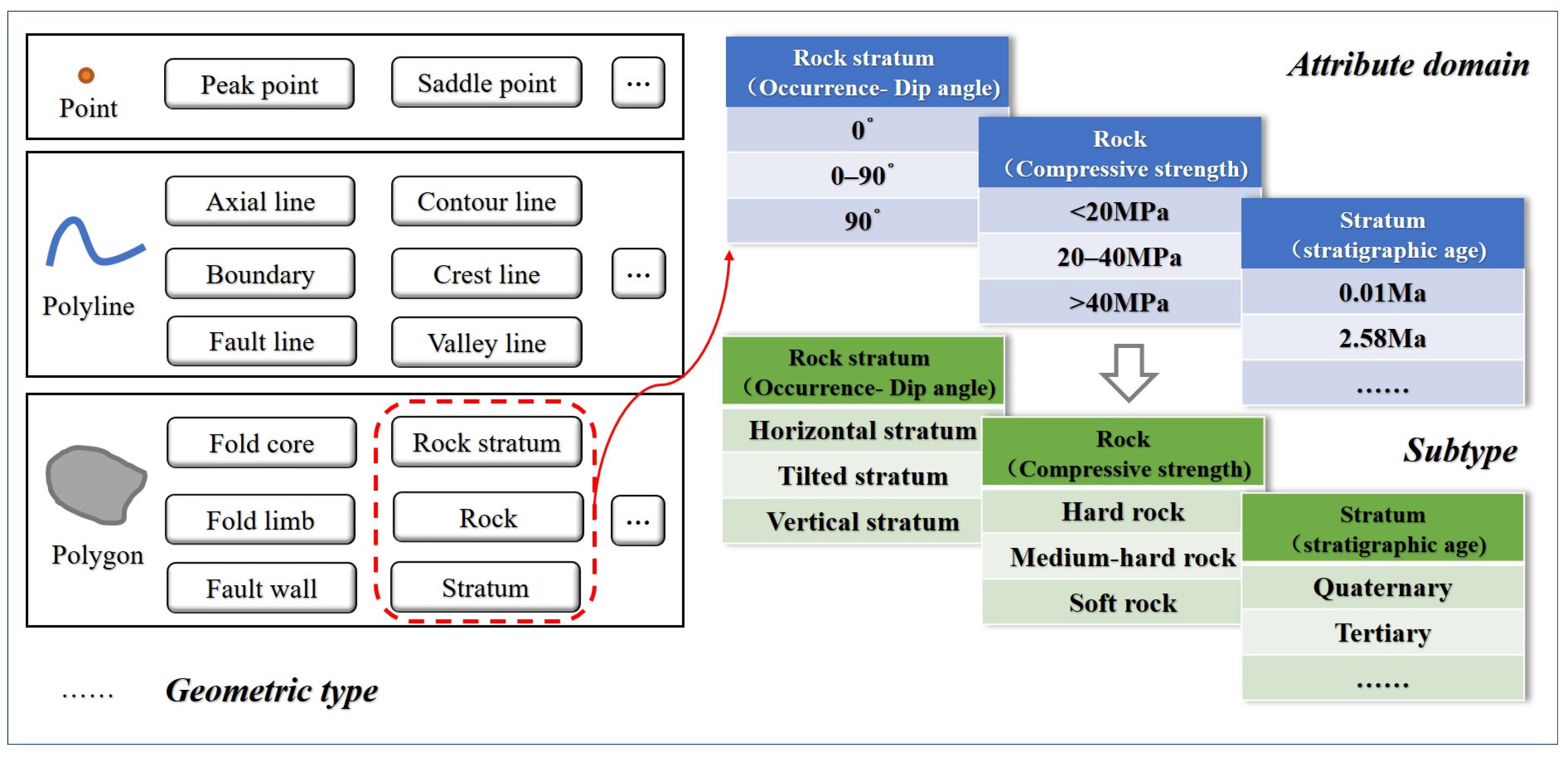
2.1. Descriptions of Elements, Characteristics, and Relationships
2.2. Definition of Structural Landforms Based on Spatial Objects and Topological Rules
2.3. SLML Method for Expressing “Forms, Elements, and Relationships”
2.3.1. SLML “Object–Attribute–Relation” Model
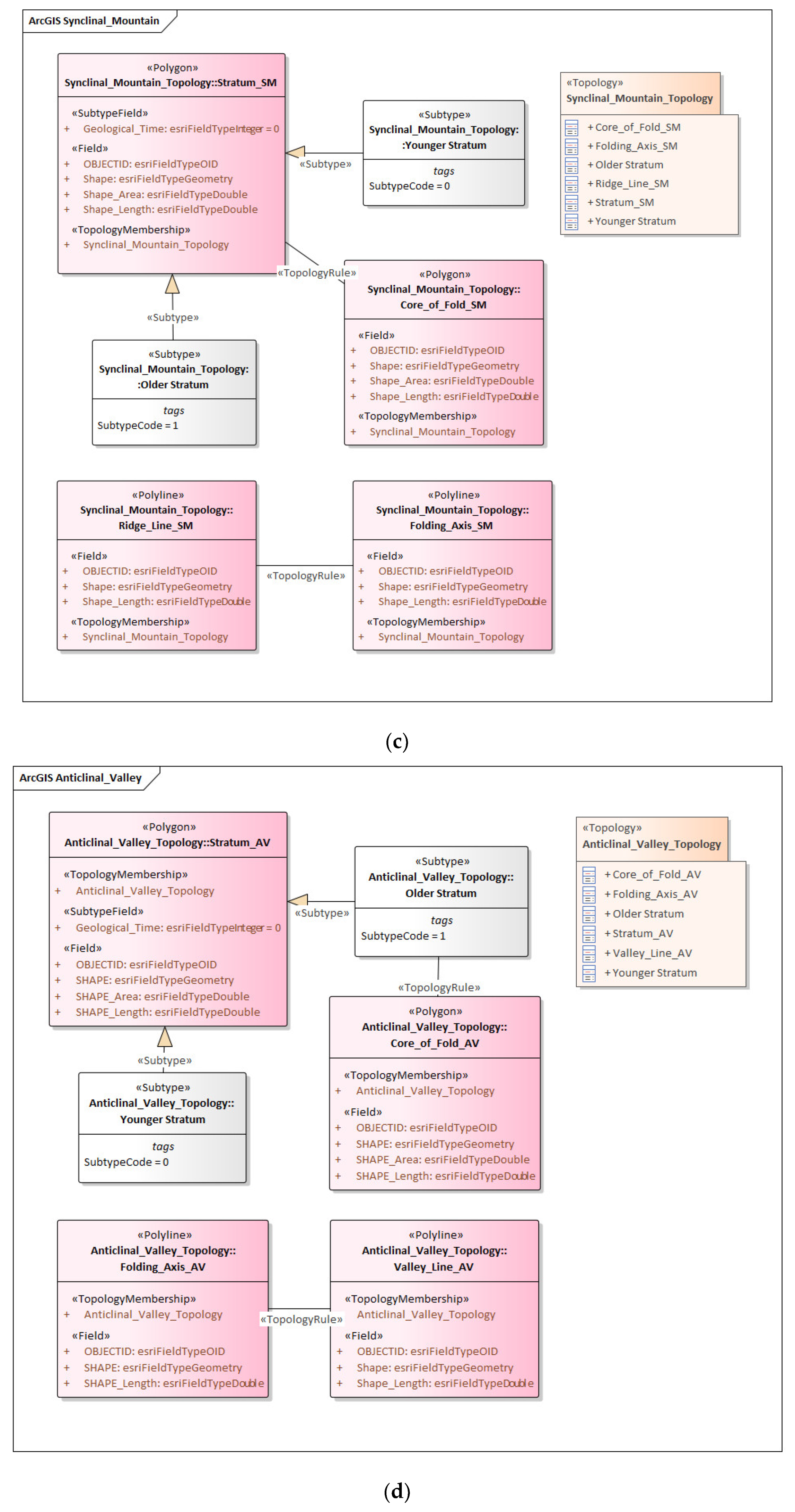
2.3.2. SLML Database Mapping and Graphical Representation Method
- In the object relational database, corresponding element types are created for strata, rocks, fault disks, fold cores, fold axes, stratigraphic boundaries, fault lines, contours, ridgelines, valley lines, and other element types.
- The corresponding object types are created for the point, polyline, polygon, and other geometry types in the object relational database.
- A relational table corresponding to complex elements is created, and the element table is associated with the table of complex types via foreign keywords.
- Associations between elements and topologies are created, and topological primitives are associated via topology–primitives and value attributes.
- Relationships between elements are created using geometric objects of the same class and foreign keywords.
2.3.3. SLML Relationship Construction
3. Experiment and Discussion
- (1)
- GIS expression of structural landforms on Qixia Mountain

- (2)
- GIS expression of the structural landforms on Gaoli Mountain

4. Conclusions
Author Contributions
Funding
Institutional Review Board Statement
Informed Consent Statement
Data Availability Statement
Acknowledgments
Conflicts of Interest
References
- Cheng, W.M.; Liu, Q.Y.; Zhao, S.M.; Gao, X.Y.; Wang, N. Research and perspectives on geomorphology in China: Four decades in retrospect. J. Geogr. Sci. 2017, 27, 1283–1310. [Google Scholar] [CrossRef]
- Xiong, L.Y.; Tang, G.A.; Yang, X.; Li, F.Y. Geomorphology-oriented digital terrain analysis: Progress and perspectives. J. Geogr. Sci. 2021, 31, 456–476. [Google Scholar] [CrossRef]
- Gutiérrez, F.; Gutiérrez, M. Landforms of the Earth: An Illustrated Guide; Springer: Cham, Switzerland, 2016; pp. 21–33. [Google Scholar]
- Gregory, K.J.; Lewin, J. The Basics of Geomorphology: Key Concepts; SAGE Publications, Ltd.: London, UK, 2014; pp. 219–248. [Google Scholar]
- Huggett, R. Fundamentals of Geomorphology; Routledge: New York, NY, USA, 2022; pp. 65–110. [Google Scholar]
- Chatterjee, S.; Goswami, A.; Scotese, C.R. The longest voyage: Tectonic, magmatic, and paleoclimatic evolution of the Indian plate during its northward flight from Gondwana to Asia. Gondwana Res. 2013, 23, 238–267. [Google Scholar] [CrossRef]
- Bourman, R.P.; Ollier, C.D.; Buckman, S. Mount Augustus Geology and Geomorphology. Geogr. Res. 2010, 48, 111–122. [Google Scholar] [CrossRef]
- Gao, M.X.; Zeilinger, G.; Xu, X.W.; Wang, Q.L.; Hao, M. DEM and GIS analysis of geomorphic indices for evaluating recent uplift of the northeastern margin of the Tibetan Plateau, China. Geomorphology 2013, 190, 61–72. [Google Scholar] [CrossRef]
- Palin, R.M.; Santosh, M. Plate tectonics: What, where, why, and when? Gondwana Res. 2021, 100, 3–24. [Google Scholar] [CrossRef]
- Rodriguez-Gonzalez, A.; Fernandez-Turiel, J.L.; Perez-Torrado, F.J.; Aulinas, M.; Carracedo, J.C.; Gimeno, D.; Guillou, H.; Paris, R. GIS methods applied to the degradation of monogenetic volcanic fields: A case study of the Holocene volcanism of Gran Canaria (Canary Islands, Spain). Geomorphology 2011, 134, 249–259. [Google Scholar] [CrossRef]
- Liang, F.Y.; Xu, B. Discrimination of tower-, cockpit-, and non-karst landforms in Guilin, Southern China, based on morphometric characteristics. Geomorphology 2014, 204, 42–48. [Google Scholar] [CrossRef]
- Raab, G.; Egli, M.; Norton, K.; Dahms, D.; Brandova, D.; Christl, M.; Scarciglia, F. Climate and relief-induced controls on the temporal variability of denudation rates in a granitic upland. Earth Surf. Process. Landf. 2019, 44, 2570–2586. [Google Scholar] [CrossRef]
- Lu, H.H.; Wu, D.Y.; Cheng, L.; Zhang, T.Q.; Xiong, J.G.; Zheng, X.M.; Li, Y.L. Late Quaternary drainage evolution in response to fold growth in the northern Chinese Tian Shan foreland. Geomorphology 2017, 299, 12–23. [Google Scholar] [CrossRef]
- Lu, H.H.; Zhang, T.Q.; Zhao, J.X.; Si, S.P.; Wang, H.; Chen, S.J.; Zheng, X.M.; Li, Y.L. Late Quaternary alluvial sequence and uplift-driven incision of the Urumqi River in the north front of the Tian Shan, northwestern China. Geomorphology 2014, 219, 141–151. [Google Scholar] [CrossRef]
- Chen, Y.C.; Sung, Q.C.; Cheng, K.Y. Along-strike variations of morphotectonic features in the Western Foothills of Taiwan: Tectonic implications based on stream-gradient and hypsometric analysis. Geomorphology 2003, 56, 109–137. [Google Scholar] [CrossRef]
- Perron, J.T.; Royden, L. An integral approach to bedrock river profile analysis. Earth Surf. Process. Landf. 2013, 38, 570–576. [Google Scholar] [CrossRef]
- Eizenhofer, P.R.; Zhao, G.C.; Zhang, J.; Sun, M. Final closure of the Paleo-Asian Ocean along the Solonker Suture Zone: Constraints from geochronological and geochemical data of Permian volcanic and sedimentary rocks. Tectonics 2014, 33, 441–463. [Google Scholar] [CrossRef]
- Nie, J.S.; Stevens, T.; Rittner, M.; Stockli, D.; Garzanti, E.; Limonta, M.; Bird, A.; Ando, S.; Vermeesch, P.; Saylor, J.; et al. Loess Plateau storage of Northeastern Tibetan Plateau-derived Yellow River sediment. Nat. Commun. 2015, 6, 8511. [Google Scholar] [CrossRef]
- Ma, Q.; Xu, Y.G. Magmatic perspective on subduction of Paleo-Pacific plate and initiation of big mantle wedge in East Asia. Earth-Sci. Rev. 2021, 213, 103473. [Google Scholar] [CrossRef]
- Schaen, A.J.; Jicha, B.R.; Hodges, K.V.; Vermeesch, P.; Stelten, M.E.; Mercer, C.M.; Phillips, D.; Rivera, T.A.; Jourdan, F.; Matchan, E.L.; et al. Interpreting and reporting 40Ar/39Ar geochronologic data. Geol. Soc. Am. Bull. 2021, 133, 461–487. [Google Scholar] [CrossRef]
- Apel, M. From 3d geomodelling systems towards 3d geoscience information systems: Data model, query functionality, and data management. Comput. Geosci. 2006, 32, 222–229. [Google Scholar] [CrossRef]
- Collon, P.; Steckiewicz-Laurent, W.; Pellerin, J.; Laurent, G.; Caumon, G.; Reichart, G.; Vaute, L. 3D geomodelling combining implicit surfaces and Voronoi-based remeshing: A case study in the Lorraine Coal Basin (France). Comput. Geosci. 2015, 77, 29–43. [Google Scholar] [CrossRef]
- Ghiglieri, G.; Carletti, A.; Da Pelo, S.; Cocco, F.; Funedda, A.; Loi, A.; Manta, F.; Pittalis, D. Three-dimensional hydrogeological reconstruction based on geological depositional model: A case study from the coastal plain of Arborea (Sardinia, Italy). Eng. Geol. 2016, 207, 103–114. [Google Scholar] [CrossRef]
- Wellmann, F.; Caumon, G. 3-D Structural geological models: Concepts, methods, and uncertainties. In Advances in Geophysics; Schmelzbach, C., Ed.; Elsevier: Amsterdam, The Netherlands, 2018; Volume 59, pp. 1–121. [Google Scholar]
- Lu, G.N.; Batty, M.; Strobl, J.; Lin, H.; Zhu, A.X.; Chen, M. Reflections and speculations on the progress in Geographic Information Systems (GIS): A geographic perspective. Int. J. Geogr. Inf. Sci. 2019, 33, 346–367. [Google Scholar] [CrossRef]
- Wei, H.; Li, S.J.; Li, C.R.; Zhao, F.; Xiong, L.Y.; Tang, G.A. Quantification of Loess Landforms from Three-Dimensional Landscape Pattern Perspective by Using DEMs. ISPRS Int. J. Geo-Inf. 2021, 10, 693. [Google Scholar] [CrossRef]
- Valkanou, K.; Karymbalis, E.; Papanastassiou, D.; Soldati, M.; Chalkias, C.; Gaki-Papanastassiou, K. Assessment of Neotectonic Landscape Deformation in Evia Island, Greece, Using GIS-Based Multi-Criteria Analysis. ISPRS Int. J. Geo-Inf. 2021, 10, 118. [Google Scholar] [CrossRef]
- He, H.D.; Hu, D.; Lu, G.N. GIS Application to Regional Geological Structure Relationship Modelling Considering Semantics. ISPRS Int. J. Geo-Inf. 2018, 7, 267. [Google Scholar] [CrossRef]
- He, H.D.; Liu, Y.R.; Cui, J.; Hu, D. Scenario Expression Method for Regional Geological Structures. ISPRS Int. J. Geo-Inf. 2022, 11, 47. [Google Scholar] [CrossRef]
- Gustavsson, M.; Kolstrup, E.; Seijmonsbergen, A.C. A new symbol-and-GIS based detailed geomorphological mapping system: Renewal of a scientific discipline for understanding landscape development. Geomorphology 2006, 77, 90–111. [Google Scholar] [CrossRef]
- Nass, A.; van Gasselt, S.; Jaumann, R.; Asche, H. Implementation of cartographic symbols for planetary mapping in geographic information systems. Planet. Space Sci. 2011, 59, 1255–1264. [Google Scholar] [CrossRef]
- FGDC Digital Cartographic Standard for Geologic Map Symbolization. Available online: https://ngmdb.usgs.gov/fgdc_gds/geolsymstd/download.php (accessed on 12 August 2023).
- The Government of Western Australia Department of Mines, Industry Regulation and Safety. Available online: https://www.dmp.wa.gov.au/Geological-Survey/Geology-and-Geophysics-1387.aspx (accessed on 12 August 2023).
- Lambiel, C.; Maillard, B.; Kummert, M.; Reynard, E. Geomorphology of the Herens valley (Swiss Alps). J. Maps 2016, 12, 160–172. [Google Scholar] [CrossRef]
- Tognetto, F.; Perotti, L.; Viani, C.; Colombo, N.; Giardino, M. Geomorphology and geosystem services of the Indren-Cimalegna area (Monte Rosa massif—Western Italian Alps). J. Maps 2021, 17, 161–172. [Google Scholar] [CrossRef]
- Jordan, G.; Meijninger, B.M.L.; van Hinsbergen, D.J.J.; Meulenkamp, J.E.; van Dijk, P.M. Extraction of morphotectonic features from DEMs: Development and applications for study areas in Hungary and NW Greece. Int. J. Appl. Earth Obs. Geoinf. 2005, 7, 163–182. [Google Scholar] [CrossRef]
- De Jong, M.G.G.; Sterk, H.P.; Shinneman, S.; Seijmonsbergen, A.C. Hierarchical geomorphological mapping in mountainous areas. J. Maps 2021, 17, 214–225. [Google Scholar] [CrossRef]
- Zangana, I.; Otto, J.C.; Mausbacher, R.; Schrott, L. Efficient geomorphological mapping based on geographic information systems and remote sensing data: An example from Jena, Germany. J. Maps 2023, 19, 2172468. [Google Scholar] [CrossRef]
- Seijmonsbergen, A.C. The modern geomorphological map. In Treatise on Geomorphology; Shroder, J., Switzer, A.D., Kennedy, D.M., Eds.; Academic Press: San Diego, CA, USA, 2013; Volume 14, pp. 35–52. [Google Scholar]
- Guo, J.T.; Wang, Z.X.; Li, C.L.; Li, F.D.; Jessell, M.W.; Wu, L.X.; Wang, J.M. Multiple-Point Geostatistics-Based Three-Dimensional Automatic Geological Modeling and Uncertainty Analysis for Borehole Data. Nat. Resour. Res. 2022, 31, 2347–2367. [Google Scholar] [CrossRef]
- Jessell, M.; Ogarko, V.; de Rose, Y.; Lindsay, M.; Joshi, R.; Piechocka, A.; Grose, L.; de la Varga, M.; Ailleres, L.; Pirot, G. Automated geological map deconstruction for 3D model construction using map2loop 1.0 and map2model 1.0. Geosci. Model Dev. 2021, 14, 5063–5092. [Google Scholar] [CrossRef]
- Song, R.B.; Qin, X.Q.; Tao, Y.Q.; Wang, X.Y.; Yin, B.; Wang, Y.X.; Li, W.H. A semi-automatic method for 3D modeling and visualizing complex geological bodies. Bull. Eng. Geol. Environ. 2019, 78, 1371–1383. [Google Scholar] [CrossRef]
- Pan, D.D.; Xu, Z.H.; Lu, X.M.; Zhou, L.Q.; Li, H.Y. 3D scene and geological modeling using integrated multi-source spatial data: Methodology, challenges, and suggestions. Tunn. Undergr. Space Technol. 2020, 100, 103393. [Google Scholar] [CrossRef]
- Zanchi, A.; Francesca, S.; Stefano, Z.; Simone, S.; Graziano, G. 3D reconstruction of complex geological bodies: Examples from the Alps. Comput. Geosci. 2009, 35, 49–69. [Google Scholar] [CrossRef]
- Manoutsoglou, E.; Lazos, I.; Steiakakis, E.; Vafeidis, A. The Geomorphological and Geological Structure of the Samaria Gorge, Crete, Greece-Geological Models Comprehensive Review and the Link with the Geomorphological Evolution. Appl. Sci. 2022, 12, 10670. [Google Scholar] [CrossRef]
- de Kemp, E.A. Spatial agents for geological surface modelling. Geosci. Model Dev. 2021, 14, 6661–6680. [Google Scholar] [CrossRef]
- Wang, Z.G.; Qu, H.G.; Wu, Z.X.; Wang, X.H. Geo3DML: A standard-based exchange format for 3D geological models. Comput. Geosci. 2018, 110, 54–64. [Google Scholar] [CrossRef]
- Lyu, M.M.; Ren, B.Y.; Wang, X.L.; Wang, J.J.; Yu, J.; Han, S.Y. Neural spline flow multi-constraint NURBS method for three-dimensional automatic geological modeling with multiple constraints. Comput. Geosci. 2023, 27, 407–424. [Google Scholar] [CrossRef]
- Colpron, M.; Nelson, J. Terrane. In Encyclopedia of Marine Geosciences; Harff, J., Meschede, M., Petersen, S., Thiede, J., Eds.; Springer: Dordrecht, The Netherlands, 2014; pp. 1–5. [Google Scholar]
- Brahmia, Z.; Hamrouni, H.; Bouaziz, R. XML data manipulation in conventional and temporal XML databases: A survey. Comput. Sci. Rev. 2020, 36, 100231. [Google Scholar] [CrossRef]
- Zhang, F.; Li, Q. Constructing ontologies by mining deep semantics from XML Schemas and XML instance documents. Int. J. Intell. Syst. 2022, 37, 661–698. [Google Scholar] [CrossRef]


| Basic Landform Type | Genetic Type | Morphological Types | Element Type | |||
|---|---|---|---|---|---|---|
| Land Relief | Altitude | Genesis | Secondary Genesis | Structural Form | Secondary Form | Structural Landform Elements |
| Plain Mesa Hills Mountain-land Tableland Butte Structural-platform | Low altitude Middle altitude High altitude Extreme high altitude | Tectonism | Stratum fluctuation | Horizontal Stratum structure | Mesa Pop-up Relief Pop-down Basin | Terrane Stratum Rock Fault Wall Core of Fold Folding Axis Stratigraphic- Boundary Fault Line Contour Line Ridge Line Valley Line …… |
| Stratum bending | Fold structure | Anticlinal Mountain | ||||
| Synclinal Mountain | ||||||
| Anticlinal Valley | ||||||
| Synclinal Valley | ||||||
| Stratum inclination | Monoclinal structure | Cuesta | ||||
| Hogback Mountain | ||||||
| Stratum fracture | Fault structure | Fault Block-Mountain | ||||
| Fault Valley Thrusts Horst Graben | ||||||
| Morphological Types | Relationship between Elements |
|---|---|
| Mesa | The terrane * occurrence is horizontal, the lithology is hard, and the stratigraphic boundary is parallel to the contour line. |
| Anticlinal Mountain | The stratum in the core of the fold is older in age, and the fold axis coincides with the ridge line. |
| Synclinal Mountain | The stratum in the core of the fold is younger in age, and the fold axis coincides with the ridge line. |
| Anticlinal Valley | The stratum in the core of the fold is older in age, and the fold axis coincides with the valley line. |
| Synclinal Valley | The stratum in the core of the fold is younger in age, and the fold axis coincides with the valley line. |
| Cuesta | The terrane occurrence is inclined, the lithology is hard, and the ridge line coincides with the stratigraphic boundary. |
| Hogback Mountain | The terrane occurrence is inclined, and the contour line coincide with the stratigraphic boundary. |
| Fault Block Mountain | The fault line overlaps with the ridge line, and the upper and lower plates of the fault wall are relative displacements. |
| Fault Valley | The fault line overlaps with the valley line, and the upper and lower plates of the fault wall are relative displacements. |
| Morphological Types | Relationship between Elements | Topological Rules |
|---|---|---|
| Mesa | The terrane occurrence is horizontal, the lithology is hard, and the stratigraphic boundary is parallel to the contour line. | Rule1: Terrane (horizontal) Must be covered by Rock (hard) Rule2: Contour_Line Must be covered by feature class of Stratigraphic_Boundary |
| Anticlinal Mountain | The stratum in the core of the fold is older in age, and the fold axis coincides with the ridge line. | Rule1: Core_of_Fold Must be covered by Stratum (Older Stratum) Rule2: Folding_Axis Must be covered by feature class of Ridge_Line |
| Synclinal Mountain | The stratum in the core of the fold is younger in age, and the fold axis coincides with the ridge line. | Rule1: Core_of_Fold Must be covered by Stratum (Younger Stratum) Rule2: Folding_Axis Must be covered by feature class of Ridge_Line |
| Anticlinal Valley | The stratum in the core of the fold is older in age, and the fold axis coincides with the valley line. | Rule1: Core_of_Fold Must be covered by Stratum (Older Stratum) Rule2: Folding_Axis Must be covered by feature class of Valley_Line |
| Synclinal Valley | The stratum in the core of the fold is younger in age, and the fold axis coincides with the valley line. | Rule1: Core_of_Fold Must be covered by feature class of Stratum (Younger Stratum) Rule2: Folding_Axis Contain point Valley_Line |
| Cuesta | The terrane occurrence is inclined, the lithology is hard, and the ridge line coincides with the stratigraphic boundary. | Rule1: Terrane (Occurrence dip < 25°) Must be covered by Rock (hard) Rule2: Ridge_Line Must be covered by feature class of Stratigraphic_Boundary |
| Hogback Mountain | The terrane occurrence is inclined, and the contour line coincide with the stratigraphic boundary. | Rule1: Terrane (Occurrence dip < 25°) Must be covered by Rock (hard) Rule2: Contour_Line Must be covered by feature class of Stratigraphic_Boundary |
| Fault Block Mountain | The fault line overlaps with the ridge line, and the upper and lower plates of the fault wall are relative displacements. | Rule1: Fault_Wall (upper) Area boundary must be covered by boundary of Fault_Wall (lower) Rule2: Fault_Line Must be covered by feature class of Ridge_Line |
| Fault Valley | The fault line overlaps with the valley line, and the upper and lower plates of the fault wall are relative displacements. | Rule1: Fault_Wall (upper) Area boundary must be covered by boundary of Fault_Wall (lower) Rule2: Fault_Line Must be covered by feature class of Valley_Line |
Disclaimer/Publisher’s Note: The statements, opinions and data contained in all publications are solely those of the individual author(s) and contributor(s) and not of MDPI and/or the editor(s). MDPI and/or the editor(s) disclaim responsibility for any injury to people or property resulting from any ideas, methods, instructions or products referred to in the content. |
© 2023 by the authors. Licensee MDPI, Basel, Switzerland. This article is an open access article distributed under the terms and conditions of the Creative Commons Attribution (CC BY) license (https://creativecommons.org/licenses/by/4.0/).
Share and Cite
Liu, Y.; Lu, G.; Meng, Z.; Guo, D.; Hu, D.; Zhu, L.; He, H. GIS Approach for Expressing Structural Landforms: Forms, Elements, and Relationships. Appl. Sci. 2023, 13, 12872. https://doi.org/10.3390/app132312872
Liu Y, Lu G, Meng Z, Guo D, Hu D, Zhu L, He H. GIS Approach for Expressing Structural Landforms: Forms, Elements, and Relationships. Applied Sciences. 2023; 13(23):12872. https://doi.org/10.3390/app132312872
Chicago/Turabian StyleLiu, Yanrong, Guonian Lu, Zhongqiu Meng, Dashu Guo, Di Hu, Lei Zhu, and Handong He. 2023. "GIS Approach for Expressing Structural Landforms: Forms, Elements, and Relationships" Applied Sciences 13, no. 23: 12872. https://doi.org/10.3390/app132312872
APA StyleLiu, Y., Lu, G., Meng, Z., Guo, D., Hu, D., Zhu, L., & He, H. (2023). GIS Approach for Expressing Structural Landforms: Forms, Elements, and Relationships. Applied Sciences, 13(23), 12872. https://doi.org/10.3390/app132312872