
Panchromatic and Multispectral Image Fusion Combining GIHS, NSST, and PCA

Abstract
:1. Introduction
2. Methods
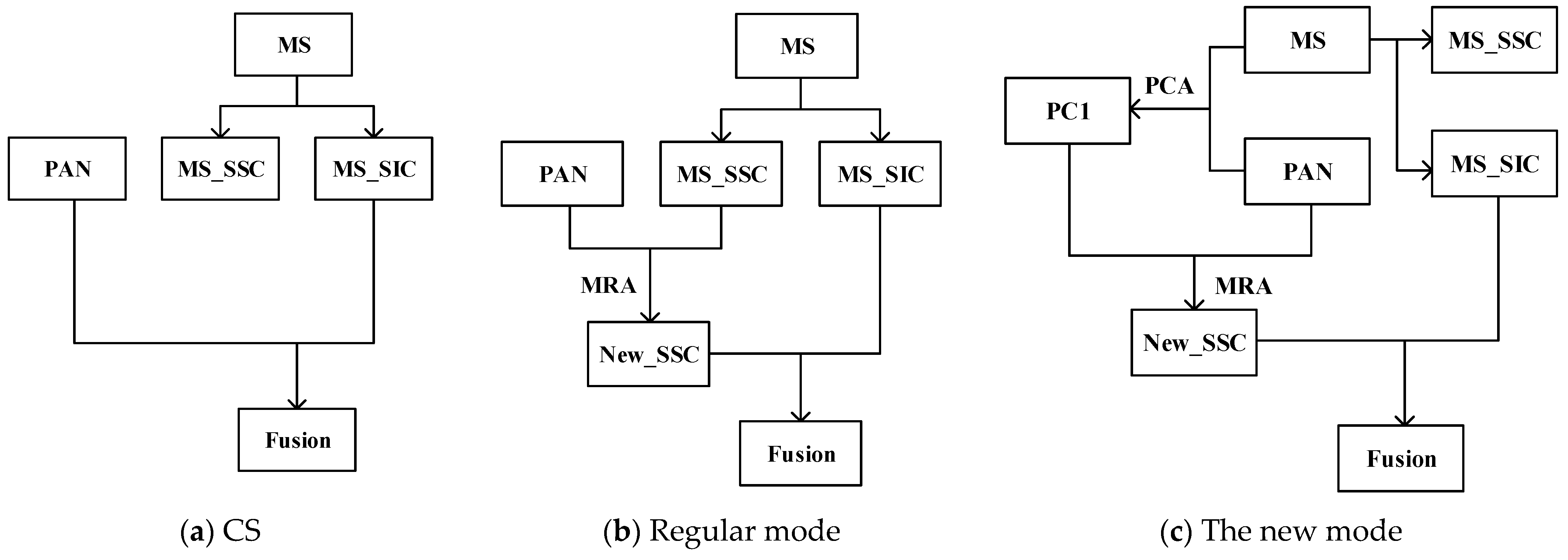
2.1. Overall Process
- (1)
- Up-sample the MS image using three convolutional interpolations to obtain , making it the same size as the PAN image.
- (2)
- Combine intensity component I according to Equation (1), perform PCA transformation on the combination of and PAN images, extract the first principal component PC1, and histogram match the PAN images and PC1 with I as the standard to obtain and .
- (3)
- Perform NSST transform decomposition of and to obtain the low-frequency components ( and the high-frequency component (, respectively.
- (4)
- Fuse the low-frequency coefficients to obtain the new low-frequency components ( and fuse the high-frequency coefficients to obtain the new high-frequency component (.
- (5)
- The new low-frequency and high-frequency components are then NSST inverse transformed to obtain the primary fusion image (), and the GAIN will be obtained (. Finally, use the f formula to obtain the fusion image (F), where the detail modulation coefficient () is set to 1.
2.2. Low-Frequency Fusion Rules
2.3. High-Frequency Fusion Rules
3. Evaluation Metrics
3.1. Evaluation Metrics with References
3.2. Evaluation Index without Reference
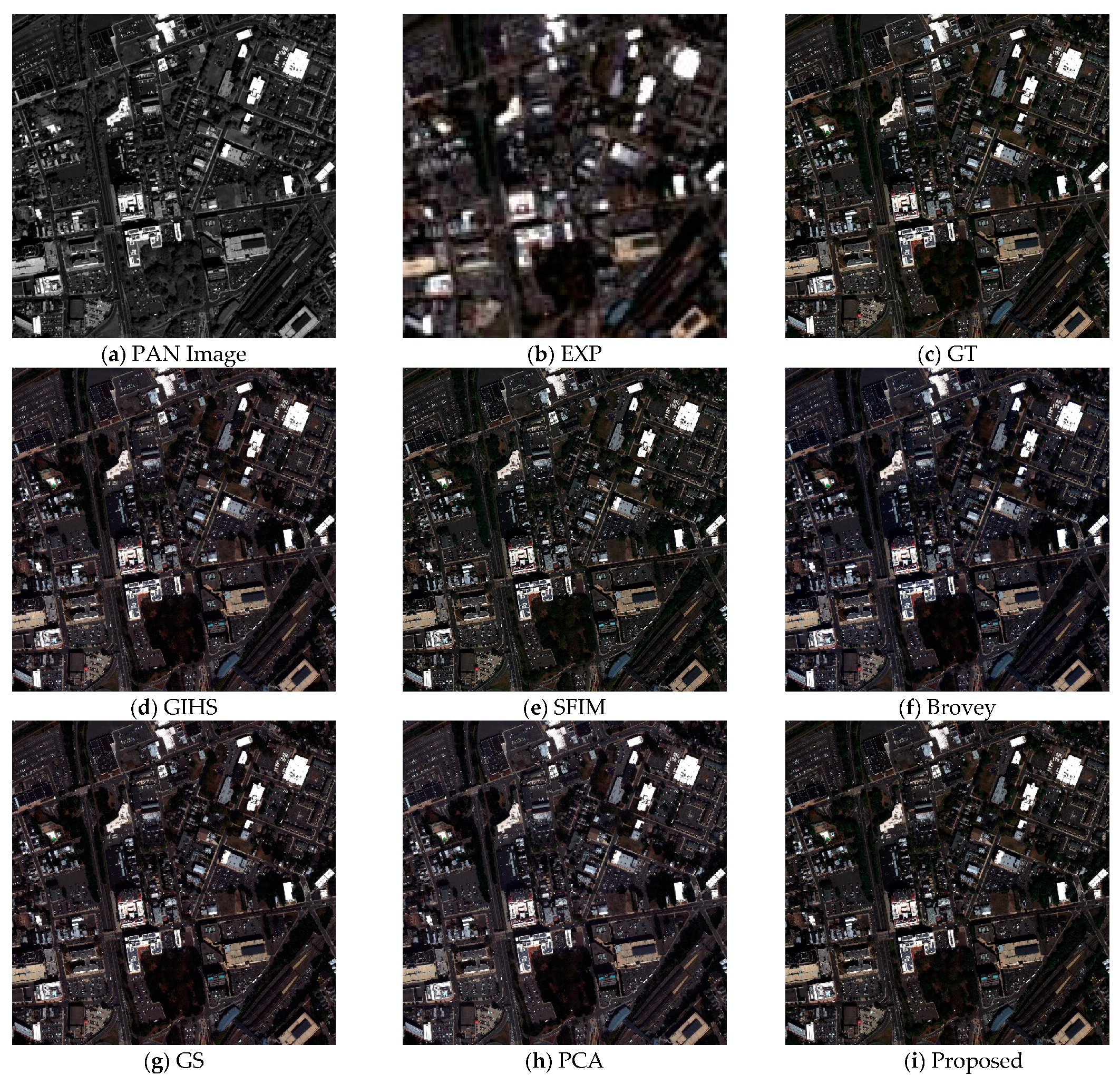
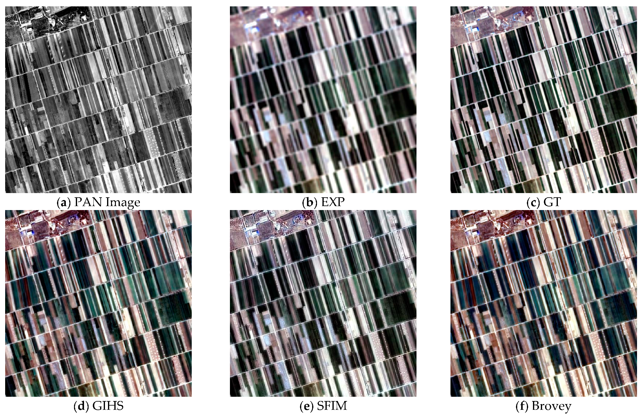
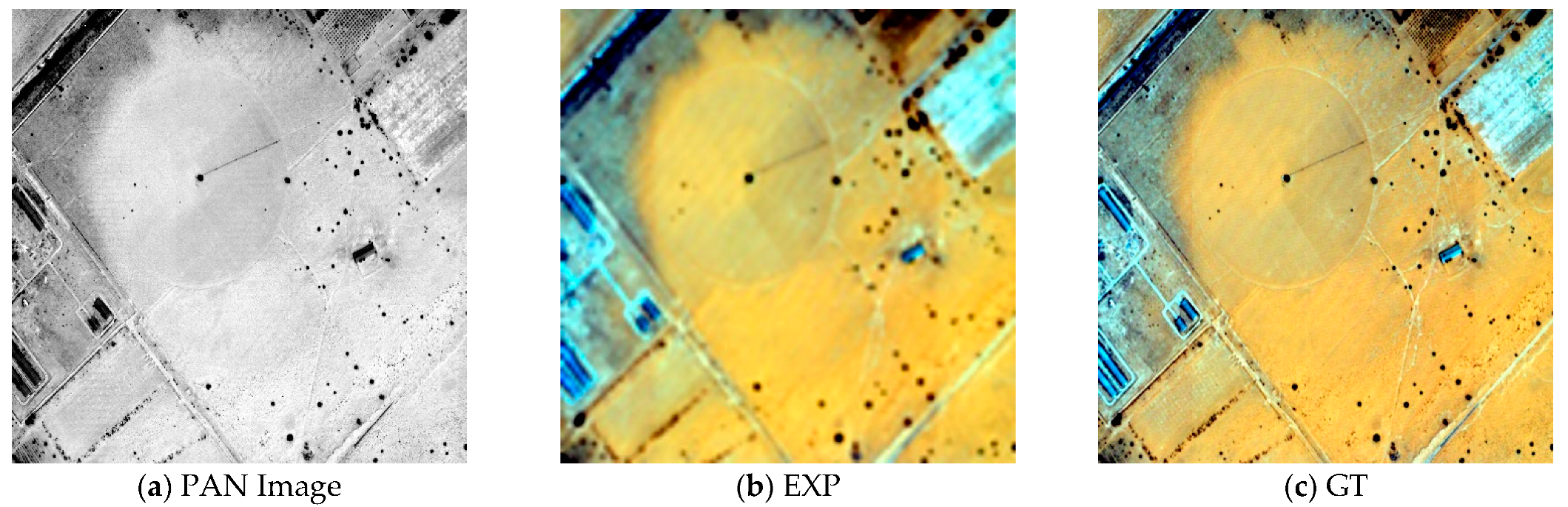
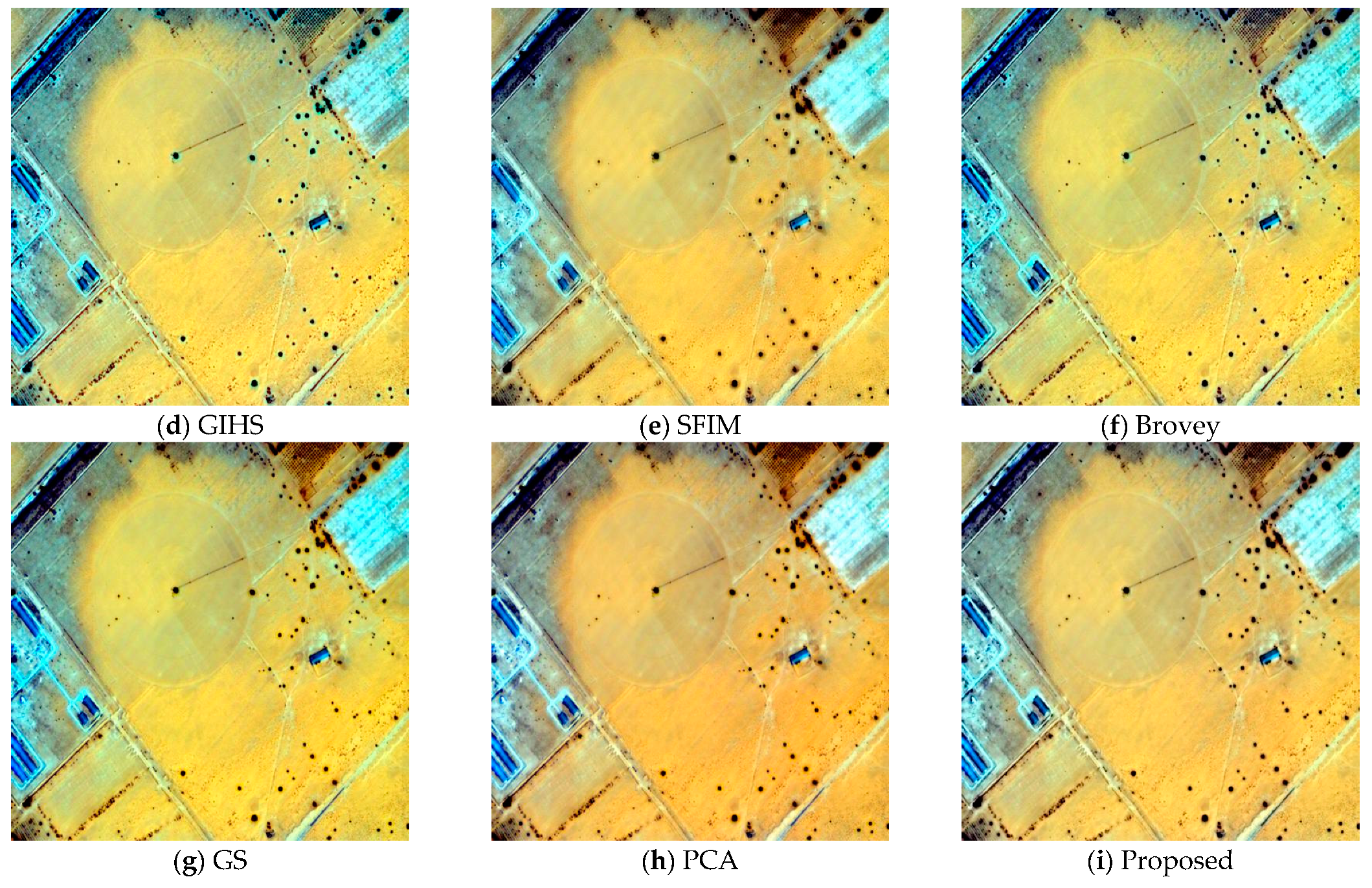
4. Results
4.1. Experiment Preparation
4.2. Experimental Results
4.2.1. Experimental Results with References
4.2.2. Experimental Results without References
5. Discussion
6. Conclusions
Author Contributions
Funding
Acknowledgments
Conflicts of Interest
References
- Wang, M.; He, L.; Cheng, Y.; Chang, X. Panchromatic and Multi-spectral Fusion Method Combined with Adaptive Gaussian Filter and SFIM Model. Acta Geod. Cartogr. Sin. 2018, 47, 82–90. [Google Scholar]
- Kang, X.; Li, S.; Benediktsson, J.A. Pansharpening With Matting Model. IEEE Trans. Geosci. Remote Sens. 2014, 52, 5088–5099. [Google Scholar] [CrossRef]
- Xing, Y.; Zhang, Y.; Yang, S.; Zhang, Y. Hyperspectral and multispectral image fusion via variational tensor subspace decomposition. IEEE Geosci. Remote Sens. Lett. 2021, 19, 5001805. [Google Scholar] [CrossRef]
- Xing, Y.; Yang, S.; Feng, Z.; Jiao, L. Dual-collaborative fusion model for multispectral and panchromatic image fusion. IEEE Trans. Geosci. Remote Sens. 2020, 60, 5400215. [Google Scholar] [CrossRef]
- Aiazzi, B.; Alparone, L.; Baronti, S.; Garzelli, A. Context-driven fusion of high spatial and spectral resolution images based on oversampled multiresolution analysis. IEEE Trans. Geosci. Remote Sens. 2002, 40, 2300–2312. [Google Scholar] [CrossRef]
- Candes, E.J.; Donoho, D.L. Recovering edges in ill-posed inverse problems: Optimality of curvelet frames. Ann. Stat. 2002, 30, 784–842. [Google Scholar] [CrossRef]
- Do, M.N.; Vetterli, M. The contourlet transform: An efficient directional multiresolution image representation. IEEE Trans. Image Process. 2005, 14, 2091–2106. [Google Scholar] [CrossRef] [Green Version]
- Da Cunha, A.L.; Zhou, J.; Do, M.N. The nonsubsampled contourlet transform: Theory, design, and applications. IEEE Trans. Image Process. 2006, 15, 3089–3101. [Google Scholar] [CrossRef] [Green Version]
- Gao, Y.; Jia, Z.; Qin, P.; Wang, L. Medical Image Fusion Based on Compressive Sensing and Adaptive PCNN. Comput. Eng. 2018, 44, 224–229. [Google Scholar]
- Kong, L.; Zhang, Z.; Zeng, X.; Wang, Q. Infrared and Visible Image Fusion Algorithm Based on NSST and SWT. Packag. Eng. 2018, 39, 216–222. [Google Scholar]
- Ghassemian, H. A review of remote sensing image fusion methods. Inf. Fusion 2016, 32, 75–89. [Google Scholar] [CrossRef]
- He, K.; Sun, J.; Tang, X. Guided Image Filtering. In European Conference on Computer Vision 2010; Springer: Berlin/Heidelberg, Germany, 2010. [Google Scholar]
- Aiazzi, B.; Baronti, S.; Selva, M. Improving component substitution pansharpening through multivariate regression of MS + Pan data. IEEE Trans. Geosci. Remote Sens. 2007, 45, 3230–3239. [Google Scholar] [CrossRef]
- Tu, T.M.; Su, S.C.; Shyu, H.C.; Huang, P.S. A new look at IHS-like image fusion methods. Inf. Fusion 2001, 2, 177–186. [Google Scholar] [CrossRef]
- Easley, G.; Labate, D.; Lim, W.Q. Sparse directional image representations using the discrete shearlet transform. Appl. Comput. Harmon. Anal. 2008, 25, 25–46. [Google Scholar] [CrossRef] [Green Version]
- Yin, M.; Liu, W.; Zhao, X.; Yin, Y.; Guo, Y. A novel image fusion algorithm based on nonsubsampled shearlet transform. Optik 2014, 125, 2274–2282. [Google Scholar] [CrossRef]
- Takeda, H.; Farsiu, S.; Milanfar, P. Kernel regression for image processing and reconstruction. IEEE Trans. Image Process. 2007, 16, 349–366. [Google Scholar] [CrossRef] [Green Version]
- Deng, L.; Yao, X. Research on the Fusion Algorithm of Infrared and Visible Images Based on Non-subsampled Shearlet Transform. Acta Electron. Sin. 2017, 45, 2965–2970. [Google Scholar]
- Ranchin, T.; Wald, L. Fusion of high spatial and spectral resolution images: The ARSIS concept and its implementation. Photogramm. Eng. Remote Sens. 2000, 66, 49–61. [Google Scholar]
- Wang, Z.; Bovik, A.C. A universal image quality index. IEEE Signal Process. Lett. 2002, 9, 81–84. [Google Scholar] [CrossRef]
- De Carvalho, O.A.; Meneses, P.R. Spectral correlation mapper (SCM): An improvement on the spectral angle mapper (SAM). In Summaries of the 9th JPL Airborne Earth Science Workshop; JPL Publication: Pasadena, CA, USA, 2000. [Google Scholar]
- Wald, L. Quality of high resolution synthesised images: Is there a simple criterion? In Proceedings of the Third Conference Fusion of Earth data: Merging Point Measurements, Raster Maps and Remotely Sensed Images, Sophia Antipolis, France, 26–28 January 2000; pp. 99–103. [Google Scholar]
- Vivone, G.; Mura, M.D.; Garzelli, A.; Restaino, R.; Scarpa, G.; Ulfarsson, M.O.; Alparone, L.; Chanussot, J. A new benchmark based on recent advances in multispectral pansharpening: Revisiting pansharpening with classical and emerging pansharpening methods. IEEE Geosci. Remote Sens. Mag. 2020, 9, 53–81. [Google Scholar] [CrossRef]
- Vivone, G.; Dalla Mura, M.; Garzelli, A.; Pacifici, F. A benchmarking protocol for pansharpening: Dataset, preprocessing, and quality assessment. IEEE J. Sel. Top. Appl. Earth Obs. Remote Sens. 2021, 14, 6102–6118. [Google Scholar] [CrossRef]
- Xie, G.; Wang, M.; Zhang, Z.; Xiang, S.; He, L. Near real-time automatic sub-pixel registration of panchromatic and multispectral images for pan-sharpening. Remote Sens. 2021, 13, 3674. [Google Scholar] [CrossRef]
- Wang, M.; Xie, G.; Zhang, Z.; Wang, Y.; Xiang, S.; Pi, Y. Smoothing Filter-Based Panchromatic Spectral Decomposition for Multispectral and Hyperspectral Image Pansharpening. IEEE J. Sel. Top. Appl. Earth Obs. Remote Sens. 2022, 15, 3612–3625. [Google Scholar] [CrossRef]
- Vivone, G.; Alparone, L.; Chanussot, J.; Mura, M.D.; Garzelli, A.; Licciardi, G.A.; Restaino, R.; Wald, L. A critical comparison among pansharpening algorithms. IEEE Trans. Geosci. Remote Sens. 2015, 53, 2565–2586. [Google Scholar] [CrossRef]
- Liu, J.G. Smoothing filter-based intensity modulation: A spectral preserve image fusion technique for improving spatial details. Int. J. Remote Sens. 2000, 21, 3461–3472. [Google Scholar] [CrossRef]
- Kwarteng, P.; Chavez, A. Extracting spectral contrast in Landsat Thematic Mapper image data using selective principal component analysis. Photogramm. Eng. Remote Sens. 1989, 55, 339–348. [Google Scholar]


| Satellite | Spatial Resolution | Image Fast Size/Pixels | Feature Type |
|---|---|---|---|
| GE-1 | 0.46 m PAN, 1.84 m MS | 2048 PAN, 512 MS | Urban |
| WV-4 | 0.31 m PAN, 1.24 m MS | 2048 PAN, 512 MS | Plants and water |
| GF-7 | 0.8 m PAN, 3.2 m MS | 2048 PAN, 512 MS | Farmland |
| GFDM | 0.5 m PAN, 2 m MS | 2048 PAN, 512 MS | Desert |
| AG | SSIM | CC | UIQI | SAM | ERGAS | |
|---|---|---|---|---|---|---|
| GT | 59.1614 | 1.0000 | 1.0000 | 1.0000 | 0.0000 | 0.0000 |
| EXP | 17.2741 | 0.5551 | 0.8404 | 0.3548 | 6.7234 | 9.4465 |
| GIHS | 33.1363 | 0.8624 | 0.9592 | 0.7738 | 6.5338 | 5.9901 |
| SFIM | 32.7685 | 0.8470 | 0.9510 | 0.7577 | 6.1840 | 5.7623 |
| Brovey | 33.0581 | 0.8555 | 0.9593 | 0.7616 | 6.7234 | 6.1109 |
| GS | 33.0537 | 0.8630 | 0.9596 | 0.7744 | 6.4007 | 5.9720 |
| PCA | 32.9883 | 0.8578 | 0.9580 | 0.7700 | 6.4326 | 6.0185 |
| Proposed | 33.1592 | 0.8757 | 0.9559 | 0.7753 | 6.5093 | 5.6390 |
| AG | SSIM | CC | UIQI | SAM | ERGAS | |
|---|---|---|---|---|---|---|
| GT | 19.4637 | 1.0000 | 1.0000 | 1.0000 | 0.0000 | 0.0000 |
| EXP | 6.7747 | 0.7495 | 0.9647 | 0.4070 | 46.5098 | 1.9421 |
| GIHS | 12.5299 | 0.9168 | 0.9845 | 0.7176 | 33.7666 | 2.2510 |
| SFIM | 11.5038 | 0.9169 | 0.9877 | 0.7100 | 30.3048 | 1.8093 |
| Brovey | 12.4041 | 0.9204 | 0.9855 | 0.7184 | 32.9954 | 1.9421 |
| GS | 12.2915 | 0.9308 | 0.9872 | 0.7311 | 32.1928 | 2.0890 |
| PCA | 12.2212 | 0.9089 | 0.9781 | 0.7120 | 39.3873 | 2.3635 |
| Proposed | 12.5323 | 0.9117 | 0.9882 | 0.7436 | 32.1953 | 2.1581 |
| AG | SSIM | CC | UIQI | SAM | ERGAS | |
|---|---|---|---|---|---|---|
| GT | 26.7046 | 1.0000 | 1.0000 | 1.0000 | 0.0000 | 0.0000 |
| EXP | 13.9148 | 0.7457 | 0.9262 | 0.5906 | 2.1305 | 1.7529 |
| GIHS | 21.3507 | 0.7901 | 0.9346 | 0.7120 | 2.1663 | 1.7281 |
| SFIM | 25.1842 | 0.8235 | 0.9444 | 0.7147 | 2.0730 | 1.4396 |
| Brovey | 21.6986 | 0.7861 | 0.9273 | 0.7061 | 2.1305 | 1.7403 |
| GS | 22.6489 | 0.7383 | 0.9035 | 0.6493 | 3.2087 | 2.0708 |
| PCA | 24.7823 | 0.5646 | 0.7376 | 0.4954 | 4.8963 | 3.1430 |
| Proposed | 21.5021 | 0.8312 | 0.9492 | 0.7149 | 2.0596 | 1.5690 |
| AG | SSIM | CC | UIQI | SAM | ERGAS | |
|---|---|---|---|---|---|---|
| GT | 9.9422 | 1.0000 | 1.0000 | 1.0000 | 0.0000 | 0.0000 |
| EXP | 3.2438 | 0.7664 | 0.9287 | 0.4348 | 0.1639 | 0.2926 |
| GIHS | 7.6976 | 0.8795 | 0.9487 | 0.6824 | 0.2107 | 0.2290 |
| SFIM | 7.8605 | 0.8993 | 0.9719 | 0.6956 | 0.1554 | 0.1755 |
| Brovey | 7.6017 | 0.8952 | 0.9602 | 0.7043 | 0.1639 | 0.2078 |
| GS | 7.7288 | 0.8876 | 0.9632 | 0.6821 | 0.1978 | 0.2171 |
| PCA | 7.8874 | 0.8890 | 0.9623 | 0.6784 | 0.2139 | 0.2008 |
| Proposed | 7.9766 | 0.9004 | 0.9503 | 0.6841 | 0.2103 | 0.2244 |
| Satellite | Index | EXP | GIHS | SFIM | Brovey | GS | PCA | Proposed |
|---|---|---|---|---|---|---|---|---|
| GE-1 | 0.0685 | 0.1090 | 0.1429 | 0.1055 | 0.1064 | 0.1259 | 0.0927 | |
| 0.1516 | 0.0298 | 0.0178 | 0.0297 | 0.0298 | 0.0196 | 0.0065 | ||
| 0.7901 | 0.8643 | 0.8417 | 0.8678 | 0.8668 | 0.8568 | 0.9012 | ||
| WV-4 | 0.1014 | 0.2130 | 0.1123 | 0.2006 | 0.1977 | 0.2737 | 0.0806 | |
| 0.2714 | 0.1123 | 0.1411 | 0.1123 | 0.1123 | 0.0923 | 0.0855 | ||
| 0.6545 | 0.6985 | 0.7623 | 0.7094 | 0.7120 | 0.6592 | 0.8406 | ||
| GF-7 | 0.0086 | 0.1114 | 0.0225 | 0.1082 | 0.1273 | 0.2889 | 0.0153 | |
| 0.2004 | 0.0375 | 0.0751 | 0.0375 | 0.0375 | 0.0103 | 0.0705 | ||
| 0.7926 | 0.8552 | 0.9040 | 0.8582 | 0.8398 | 0.7036 | 0.9152 | ||
| GFDM | 0.0426 | 0.2020 | 0.0271 | 0.1876 | 0.0312 | 0.1354 | 0.0459 | |
| 0.0694 | 0.0312 | 0.0253 | 0.0312 | 0.1372 | 0.0253 | 0.0197 | ||
| 0.8908 | 0.7729 | 0.9482 | 0.7869 | 0.8357 | 0.8425 | 0.9351 |
Disclaimer/Publisher’s Note: The statements, opinions and data contained in all publications are solely those of the individual author(s) and contributor(s) and not of MDPI and/or the editor(s). MDPI and/or the editor(s) disclaim responsibility for any injury to people or property resulting from any ideas, methods, instructions or products referred to in the content. |
© 2023 by the authors. Licensee MDPI, Basel, Switzerland. This article is an open access article distributed under the terms and conditions of the Creative Commons Attribution (CC BY) license (https://creativecommons.org/licenses/by/4.0/).
Share and Cite
Xu, L.; Xie, G.; Zhou, S. Panchromatic and Multispectral Image Fusion Combining GIHS, NSST, and PCA. Appl. Sci. 2023, 13, 1412. https://doi.org/10.3390/app13031412
Xu L, Xie G, Zhou S. Panchromatic and Multispectral Image Fusion Combining GIHS, NSST, and PCA. Applied Sciences. 2023; 13(3):1412. https://doi.org/10.3390/app13031412
Chicago/Turabian StyleXu, Lina, Guangqi Xie, and Sitong Zhou. 2023. "Panchromatic and Multispectral Image Fusion Combining GIHS, NSST, and PCA" Applied Sciences 13, no. 3: 1412. https://doi.org/10.3390/app13031412
APA StyleXu, L., Xie, G., & Zhou, S. (2023). Panchromatic and Multispectral Image Fusion Combining GIHS, NSST, and PCA. Applied Sciences, 13(3), 1412. https://doi.org/10.3390/app13031412