Article

The Impact of Clay Minerals on the Porosity Distribution of Clastic Reservoirs: A Case Study from the Labuan Island, Malaysia

1
Geoscience Department, Faculty of Natural Sciences and Information Technology, Universiti Teknologi PETRONAS, Seri Iskandar 32610, Perak, Malaysia
2
Geology Department, Faculty of Science, Alexandria University, Alexandria 21568, Egypt
3
Southeast Asia Clastic and Carbonate Research Laboratory, Geoscience Department, Universiti Teknologi PETRONAS, Seri Iskandar 32610, Perak, Malaysia
4
Department of Natural Resources Engineering and Management, School of Science and Engineering, University of Kurdistan Hewlêr, Erbil 44001, Kurdistan Region, Iraq
5
Geochemistry ALS Global, Vancouver, Dollarton Hwy2103, North Vancouver, BC V7M 1H9, Canada
*
Author to whom correspondence should be addressed.
Appl. Sci. 2023, 13(6), 3427; https://doi.org/10.3390/app13063427
Submission received: 24 October 2022 / Revised: 13 February 2023 / Accepted: 20 February 2023 / Published: 8 March 2023
(This article belongs to the Section Earth Sciences)

Abstract

:
Clay mineral content and diagenetic processes are vital factors that affect reservoir quality, especially in tight clastic reservoirs, which are crucial for industrial and scientific purposes. The presence of clay minerals poses one of the most significant challenges in evaluating sandstone reservoirs’ quality. Even though wireline logs may provide a good indication of the reservoir quality, there have been cases where they have failed. This work focuses on the clay minerals’ impact on the porosity and permeability of a clastic reservoir. Typical outcrops from Labuan Island, Brunei–Sabah Basin, were chosen as a case study to investigate the petrophysical and petrographic parameters together with clay mineralogy profiling. The effects of the clays on the petrophysical parameters of the sandstone reservoir were evaluated through air permeability, spectral gamma ray measurements, a petrographic thin section analysis, a visual porosity estimation, and a grain size analysis. Field and petrographic studies revealed that Belait and Temburong formations contain massive, interbedded, laminated, and cross-bedded sandstones. Using an image analysis of the thin sections, porosity values ranged from 7.3% to 23.5%, with different macro and micro porosity distributions. According to the spectral gamma-ray investigation and air permeability, permeability reduction is strongly associated with clay minerals. The microporosity and permeability of the analyzed samples showed a unique pattern influenced by the grain size distribution. It was found that the textures dominated by mud grain size had a more significant impact on the air permeability and visual porosity, with coefficient of determination values of 0.83 and 0.70, respectively. The Belait Formation displayed a higher porosity and permeability compared to the Temburong Formation. This research provides new insight into the potential reservoir of Stage IV (the Belait Formation offshore equivalent) compared to Stage II (the Temburong Formation offshore equivalent).

1. Introduction

For clastic reservoirs, one of the most challenging issues is to accurately assess the quality of the reservoir in the presence of clay minerals. Various clay minerals can be found in reservoirs, both as primary or diagenetic products, in different forms and compositions. Depending on the shale type, they can take different forms, including detrital shale, clasts, or as dispersed matrix between quartz grains. Based on their composition clay minerals could have a specific site in the pores; for instance, kaolinite can fill pores, chlorite can line pores, and illite can bridge pores [1]⁠⁠. Clay mineral content affects the petrophysical and hydraulic properties of clastic reservoirs. It has been documented that the porosity and permeability of sandstone reservoirs are directly affected by the development of clay minerals [2]⁠. The diagenetic parameters are responsible for most of the heterogeneity in sandstone reservoirs [3], which is considered being one of the main problems facing the oil and gas industry. Onshore outcrop datasets provide a good analogue for similar geologic settings and depositional environments of offshore basins for reservoir modeling and characterization [4]. Therefore, it is necessary to understand the processes at a microscopic level to predict the quality of a clastic reservoir. Depending on how micropores are distributed and developed, the reservoir quality can either be enhanced or reduced, which may affect how much hydrocarbon can be recovered. It is essential to make field observations, describe outcrops, sample the reservoir, and conduct petrophysical investigations to assess reservoir properties; hence the clastic reservoirs in the Sabah Basin are no exception. Several changes affecting the lithofacies could influence the evolution of the pore system in oil and gas reservoirs [5], which are required to understand the role of diagenesis in porosity development⁠. Labuan Island represents a connection between onshore and offshore Sabah. It is considered to be in a geologically strategic location between offshore Sabah and Brunei [6]⁠. Labuan is situated within the Brunei–Sabah Basin [7]⁠. This paper aims to provide a better understanding of the role of clay minerals in clastic reservoirs and how those minerals can improve or reduce the quality of the reservoir, through (a) studying some sandstone intervals and samples collected from the Labuan Island outcrops to evaluate the porosity and permeability, (b) understanding the sedimentological and diagenetic parameters from thin section analysis and grain size analysis, (c) evaluating the clay minerals’ distribution using the Th and K concentrations cross-plot, (d) determining the effect of the clay minerals on the porosity using image analysis and differentiating the micro from macropores, (e) evaluating the permeability in the presence of clay minerals, and (f) correlating the different relations among the porosity, permeability, and distribution of grain sizes.

2. Geological and Stratigraphic Setting

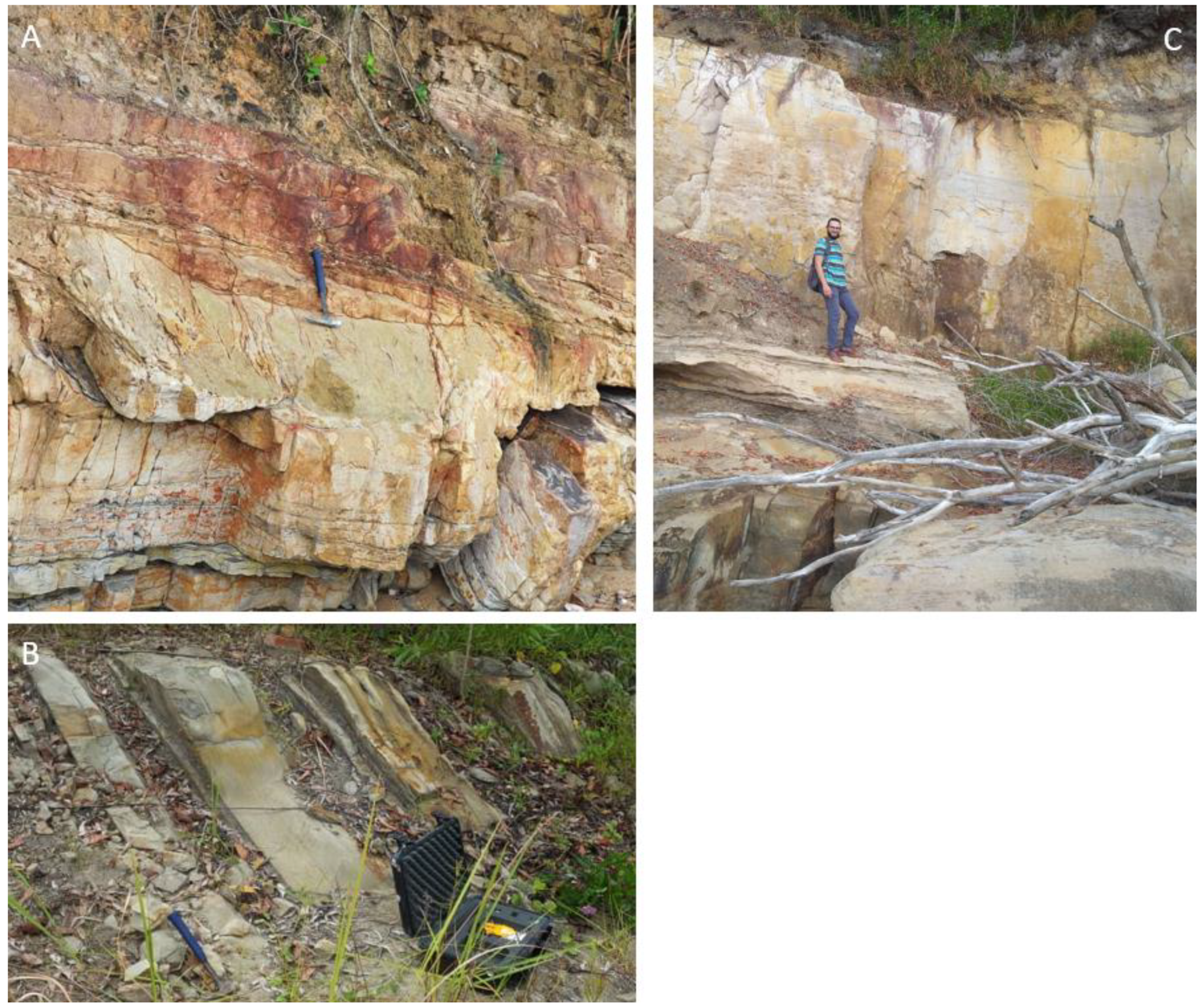
Labuan Island is part of the Brunei–Sabah Basin [8]. It is a plunging anticline that mainly controls the topography of the Island, where the highest elevation is 85 m [9]. Labuan is situated 8 km west of the Sabah shores and north of Brunei, in the southeast of the South China Sea (Figure 1). Sabah is located in the north of Borneo, and covers an area of about 73,000 km2 [10]⁠. Figure 2 presents outcrops of the Belait Formation sandstone with coal intercalations (A), the interbedded fine-grained sandstone of the Temburong Formation (B), and the lower Belait Formation massive sandstone (C).
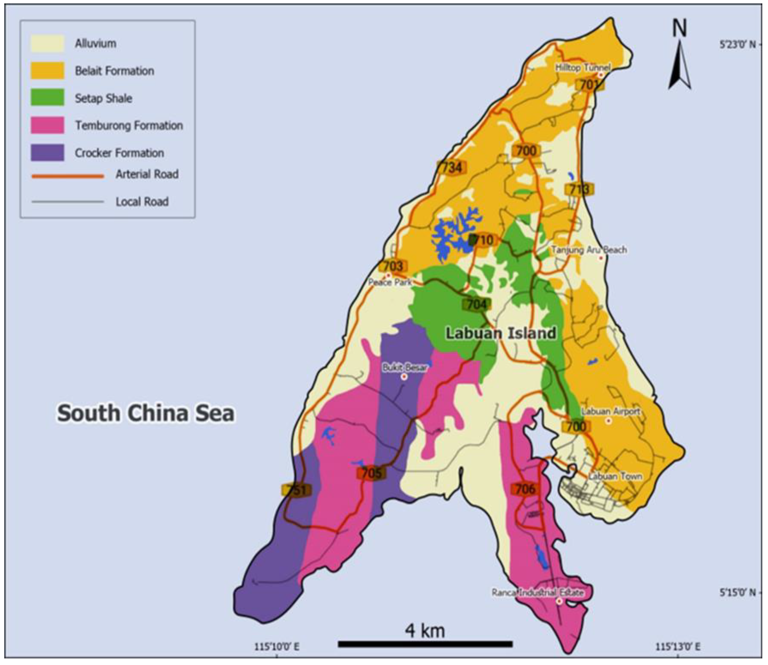
The Sabah Basin is divided into four distinct areas—the western lowlands, west cordillera, central uplands, and eastern lowlands. This study focused on Labuan Island as part of the Sabah Basin, northwest of Borneo Island. The island’s stratigraphy shows four formations. The Crocker and Temburong formations represent the deep marine, while the shallow marine sequence is represented by the Setap and Belait Formations. The two groups are separated by the Middle Miocene Age’s unconformity, known as the deep regional unconformity (DRU) [11]⁠. This paper will focus on two formations: Temburong, and Belait (Figure 3). These formations reflect their offshore equivalent stages: II, III; and IV, respectively [12]⁠. Temburong and Crocker structurally form the central core of the anticline⁠. Setap Shale is characterized as a shallow marine argillaceous shale intercalated with siltstone and limestone [13], deposited during the Early to Middle Miocene [9]⁠. Setap shale covers the central area of the island [14]⁠⁠. Belait was deposited during the Middle to Late Miocene⁠ and considered to be a shallower fining upward formation with a texture that starts with the conglomerate, to pebbly sandstone at the bottom and shale and coal on top [15]⁠. Belait’s base was considered to be an erosional part, as it descriptively matches the DRU in the offshore sequences [16]⁠. Several researchers have attempted to investigate the geological history of the Labuan Island from several perspectives.There were numerous studies, especially over the previous couple of years. Lukie and Balaguru [12] have conducted a sedimentological study on the base of the Belait Formation to provide some information about the offshore equivalents. They did not cover much about petrophysics in their study. Nazaruddin et al. [9] studied the geologic properties through eight outcrops, but with no details about their petrographical or petrophysical aspects. Som and Abdul Kadir [17] studied Belait outcrops and used the presence of facies to detect the continuity of the formation. Zainal Abidin [13]⁠ presented a field facies analysis on some outcrops based on their field characteristics, although there was no report on laboratory analyses.

3. Materials and Methods

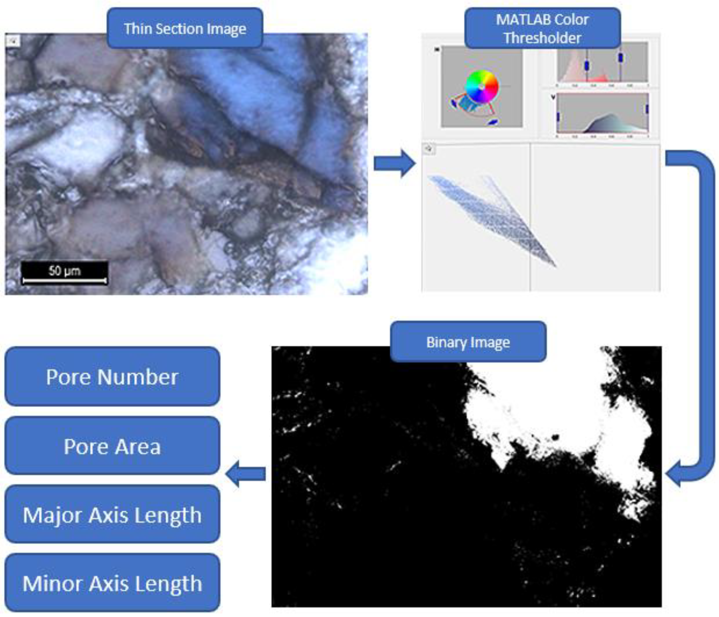
To determine the petrographical relationship between the quartz grains and clay minerals, thin sections were prepared from core plugs of the exposed outcrops. The study was conducted to evaluate the presence of clay minerals and their impact on reservoir quality, as well as to obtain a microporosity and macroporosity identification based on image analysis, using blue epoxy-impregnated thin sections. Typically, the epoxy is tinted blue to make it simple to see the porosity. A fluorescent dye can stain the epoxy either during or after the thin sectioning. This method’s key benefit is that it makes it easier to see relatively small pores in the thin sections when fluorescent light is shone on them. MATLAB image processing tools were used for the thin section analysis. The clay type was mainly determined by spectral gamma-ray (SGR) analysis together with sedimentary log interpretation. Geostatistical analyses were applied for grain size distribution and related parameters. The RGB image’s blue regions look noticeably brighter than those in the grayscale image. The blue pixels were isolated by removing the grayscale from the blue channel. Compared with the RGB input image, the grayscale image is brighter in the blue regions. By identifying a threshold value, the image was converted into a binary one using only two colors, black and white, representing the grains and the pores. The image analysis tool in MATLAB was used to convert the blue-impregnated thin sections into binary black-and-white images. A color threshold application was used to visually identify the blue areas in the thin section to distinguish the pore spaces from solid grains. Additionally, an image region analyzer tool was used on the binary image to calculate the diameter of each pore space (white areas), to classify and rearrange the spaces based on the diameter, and to identify the micropore spaces from macropore spaces (Figure 4).
A grain size analysis was performed using a collection of sieves of various mesh sizes. Every sieve had square openings of a specific size and shape. The weight of the samples varied from 500 g to 1000 g. Then, the samples were crushed using a pestle mortar to avoid deforming the original grain size. The samples were sieved using the shaker for 10 min using a stack of sieves (Table 1). A scientific scale was then used to measure the remaining weights of each sieve. The hydrometer test was performed as part of the grain size analysis for the grains passing through the 75 μm sieve, to complete the distribution curve. The hydrometer analysis was based on the difference in the particles settling in water (Figure 5). The rate at which the particles separated from their suspension in a liquid could be used to estimate the particle size. The sample preparation procedure used powdered materials that had been sieved up to that size, since the analysis requires fine-grained samples. The data from the sieve analysis and the hydrometer test were merged to provide a complete view of the grain size distribution of the entire sample. Phi values from 0 to 9, reflecting the particle sizes from very coarse sand to clay size, were converted to present the sieves and the hydrometer test radii. The distribution of the grain sizes in proportion to the average (sorting), the symmetry or preferential distribution of a specific side of the average value (skewness), and the degree of grain concentration around one grain size value (kurtosis). The points: ϕ5, ϕ16, ϕ25, ϕ50, ϕ75, ϕ84, and ϕ95 on the grain size cumulative frequency distribution curves presented in the discussion section (the grain size at which a particular percentage of the grains are coarser) are gathered to be able to calculate the statistical parameters using the following Equations (1)–(4) [19]:
Mz = (ϕ16 + ϕ50 + ϕ84)/3
σ1 = (ϕ84 – ϕ16)/4 + (ϕ95 – ϕ5)/6.6
Sk1 = (ϕ16 + ϕ84 – (2ϕ50)/(2(ϕ84 – ϕ16)) + (ϕ5 + ϕ95 – 2ϕ50)/(2(ϕ95 – ϕ5))
KG = (ϕ95 – ϕ5)/(2.44(ϕ75 – ϕ25))
Mz is the graphic mean, σ1 is the graphic standard deviation, Sk1 is the skewness, and KG is the kurtosis.
A portable air permeability meter (Figure 6) was used in this study to provide fast, in situ permeability measurements using a Tinyperm II manufactured by (New England Research, Inc. White River Junction, VT, USA), which measures the permeability of rocks by injecting air through part of the rock surface area and calculating the time taken for the pressure created to be released. Accessible spots at each outcrop along each formation were selected to provide several representative points for the Belait and Temburong Formations. The permeameter detected the permeability within the 1 to 1000 mD range [20]. An average of the multiple readings was taken from the interval to obtain a representative result, and then the measurements were converted into millidarcy using (Equation (5)) [18].
Tinyperm II measurement = −0.8386 × log10 (Kair) + 12.967
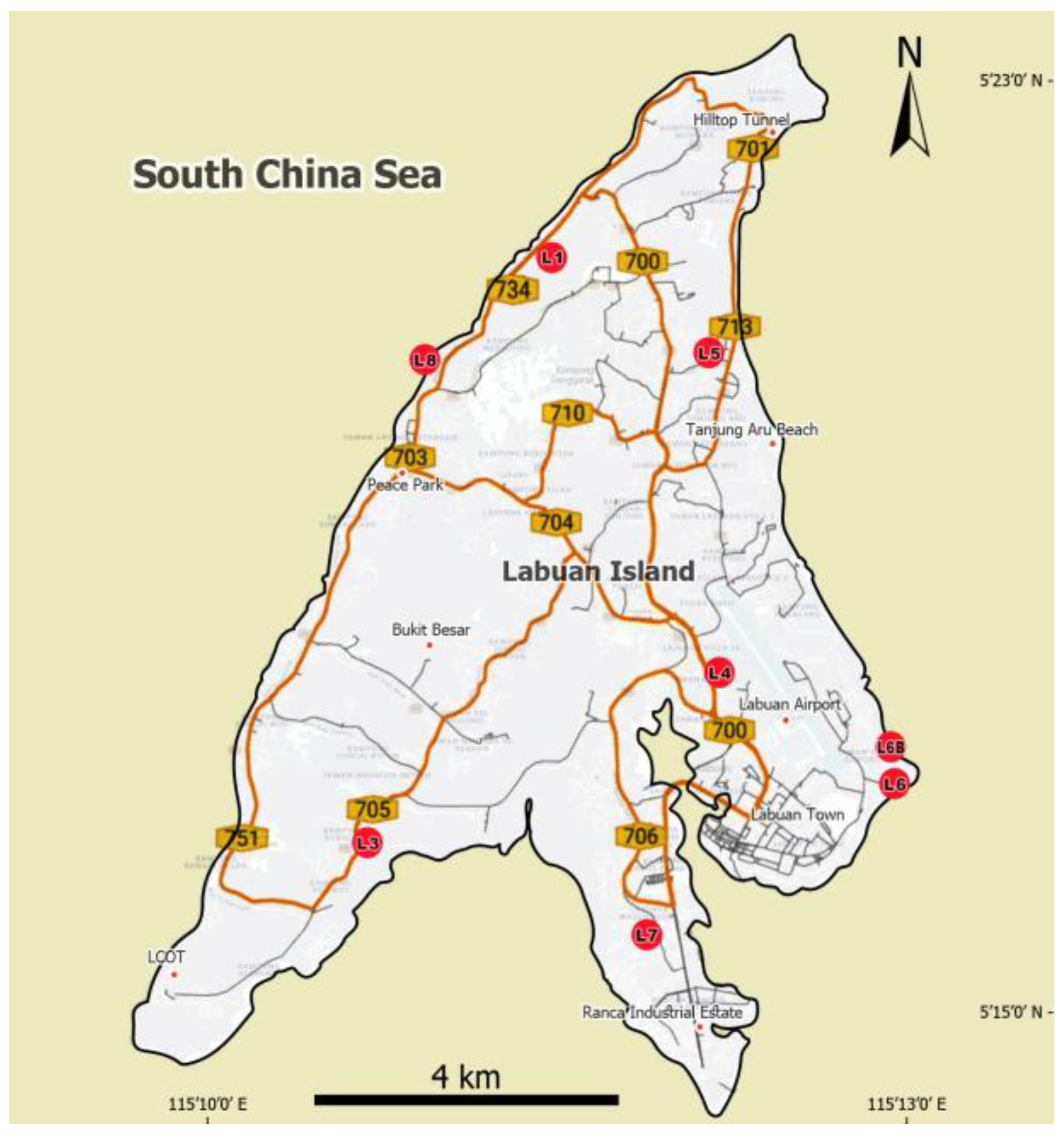
A portable spectral gamma-ray (Gamma Surveyor II), manufactured by (GF Instruments, Brno-Medlánky, Czech Republic), was used to classify the clay minerals. The surveyor measures potassium as a percentage, uranium in ppm, and thorium in ppm. The SGR surveyor was used for the clay type determination based on the potassium and thorium content. The manufacturer’s specifications state that the relative error for low radioactivity readings within a 3 min measurement duration is 6% for K and 16% for Th. Therefore, for more accurate measurements, the measurements were repeated three times (a total of 9 min per interval), where the lowest and the highest readings were neglected [21]. Data were collected from eight outcrops, L1, L3, L4, L5, L6, L6B, L7, and L8 (Figure 7). Spectral gamma-ray full logs have been collected along two outcrops, L1 and L5. On the other hand, selected spots from the other outcrops were measured.

4. Results

Detailed observations and samples from eight outcrops (L1, L3, L4, L5, L6, L6B, L7, and L8) were analyzed. The studied outcrop locations are marked in Figure 7 above. The results are presented in two sections: petrographical and petrophysical parameters.

4.1. Petrographical Parameters

This includes field observations, the thin section analysis, the porosimetry measurements, and the grain size analysis.

4.1.1. Field Observations

Field data, including data on the thicknesses, lithologies, textures, descriptions, and spectral gamma-rays, were represented in sedimentary logs for L1 and L5, as shown in Figure 8 and Figure 9 below. The logs were autogenerated using TechLog, based on the shale volume calculated by the software. In the L1 outcrop, the field data description is combined and shown below with the SGR data, which was used to calculate the volume of the shale along the outcrop (Figure 8 and Figure 9). The volume of the shale increased in some parts of the sequence, where the readings of Th, U, and K were high, and vice versa. The amount of the shale demonstrated can explain the intimate nature of this part of the Belait Formation. On the other hand, L5 shows less shale, represented by the fragile beds and domination of sandstone beds.

4.1.2. Thin Section Study

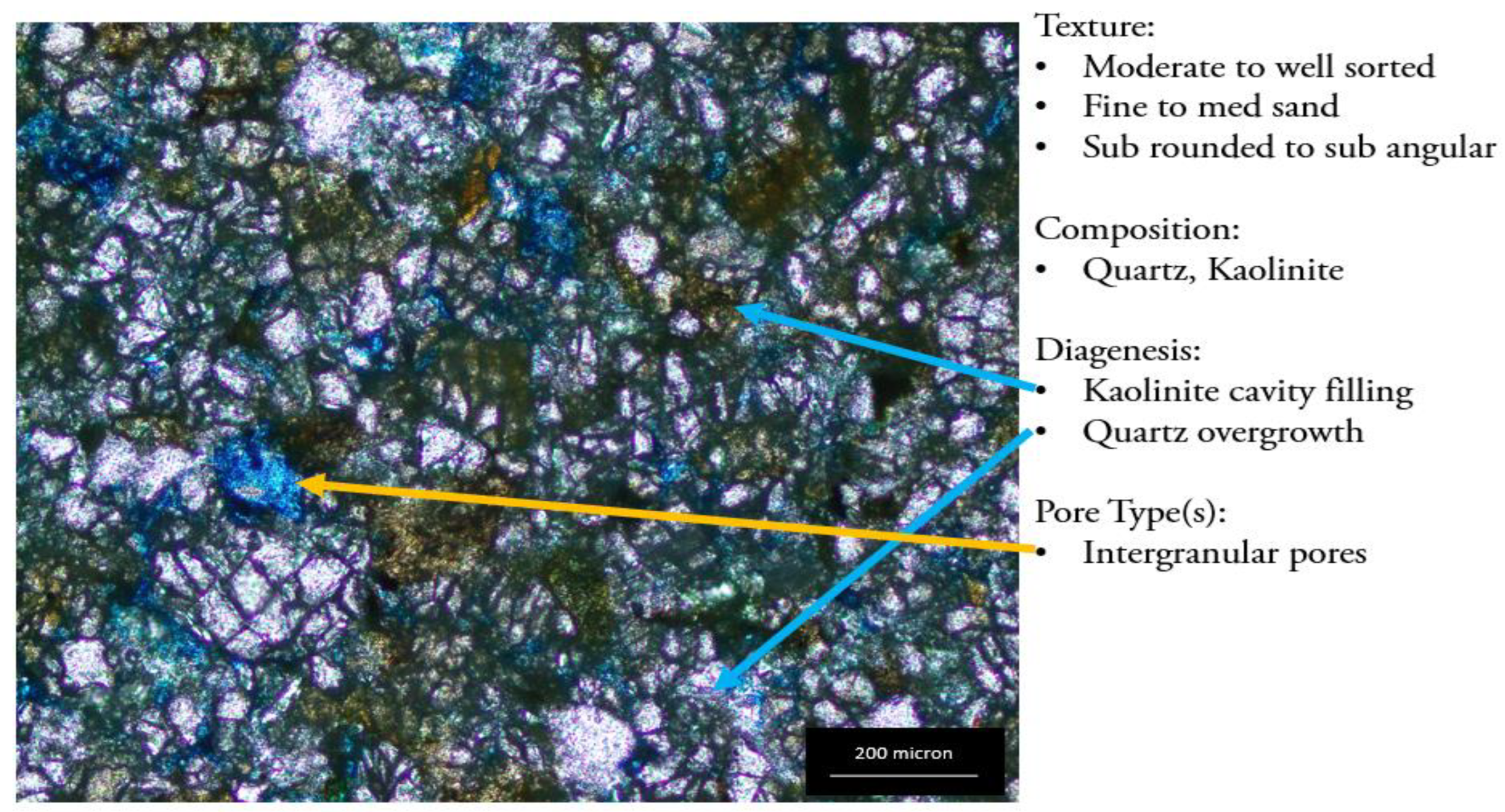
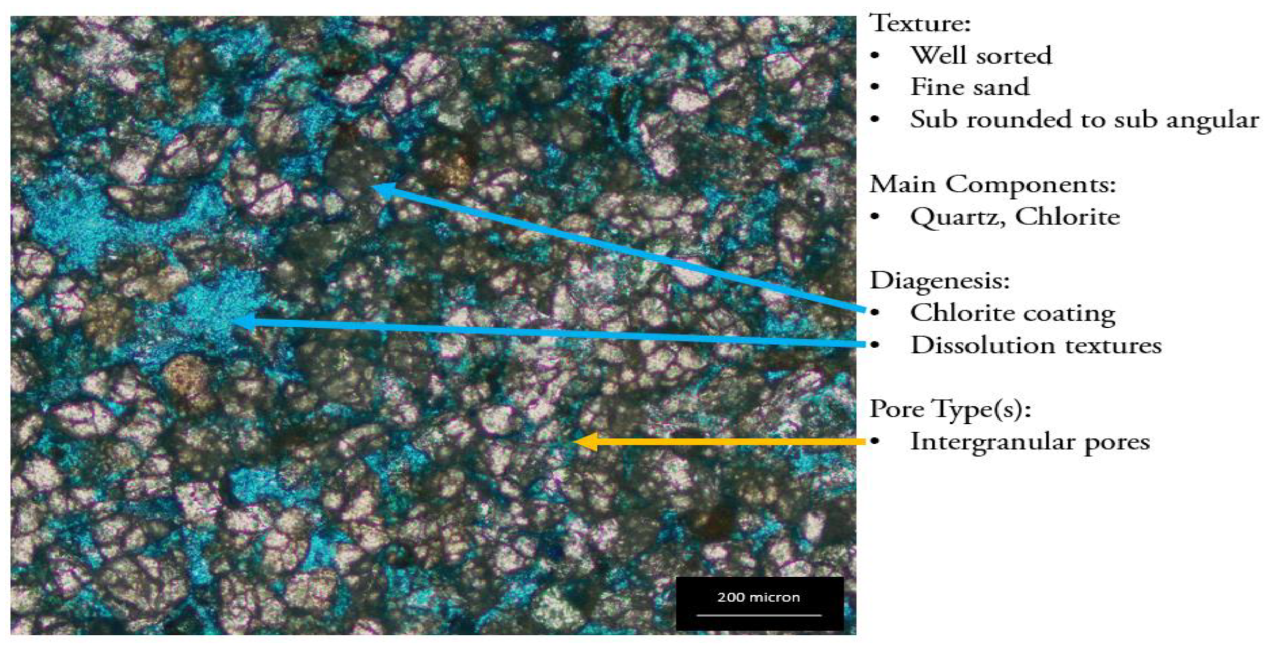
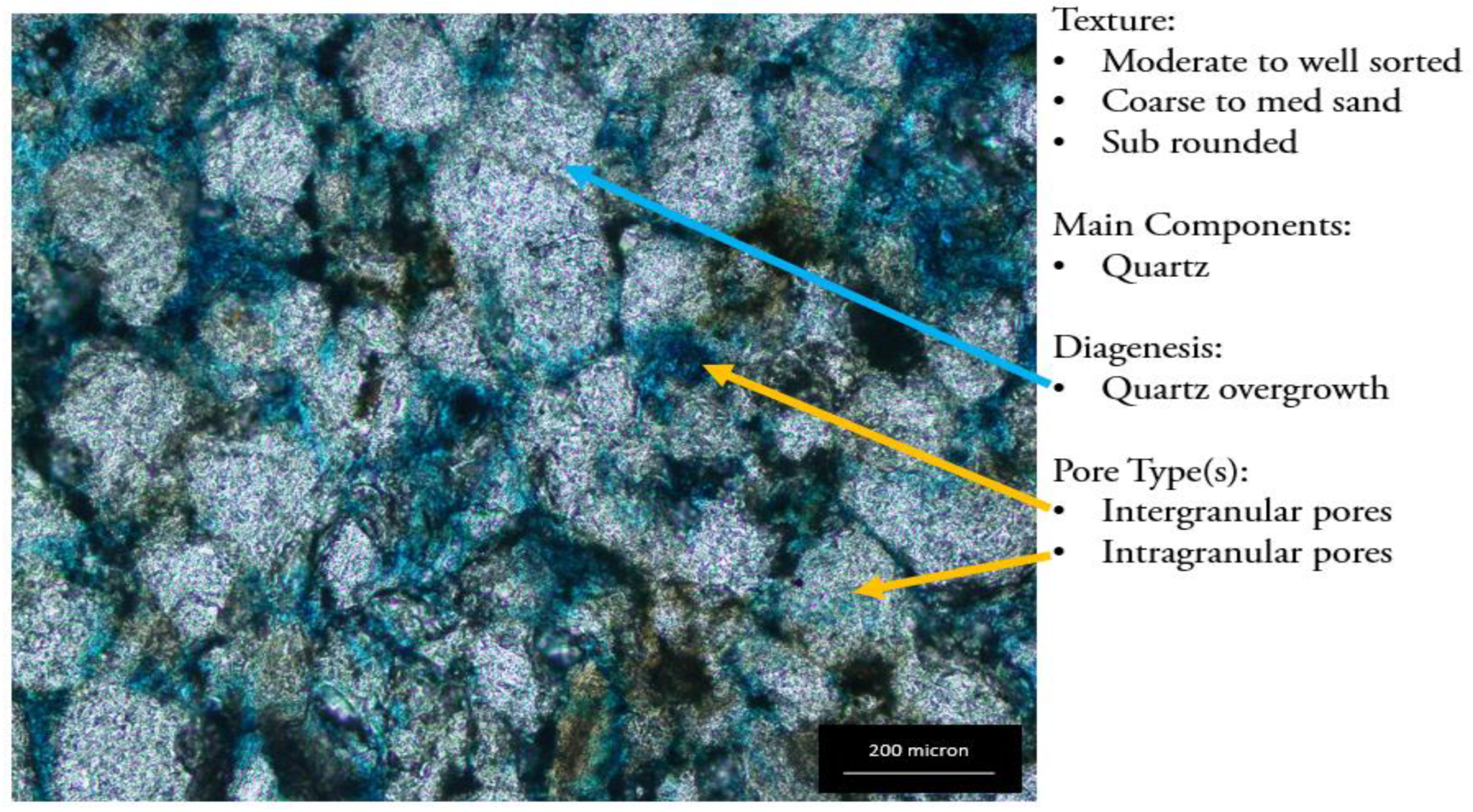
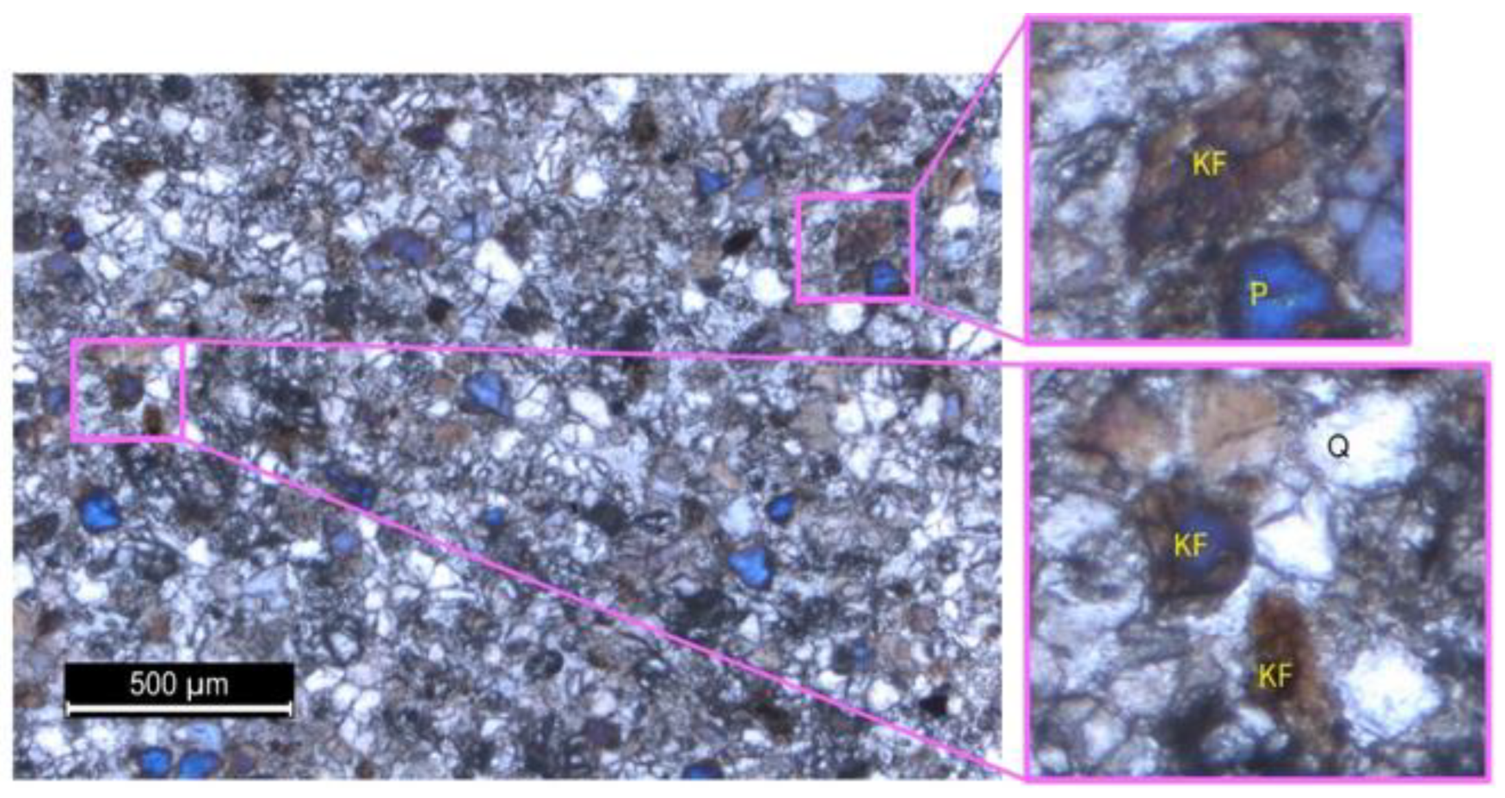
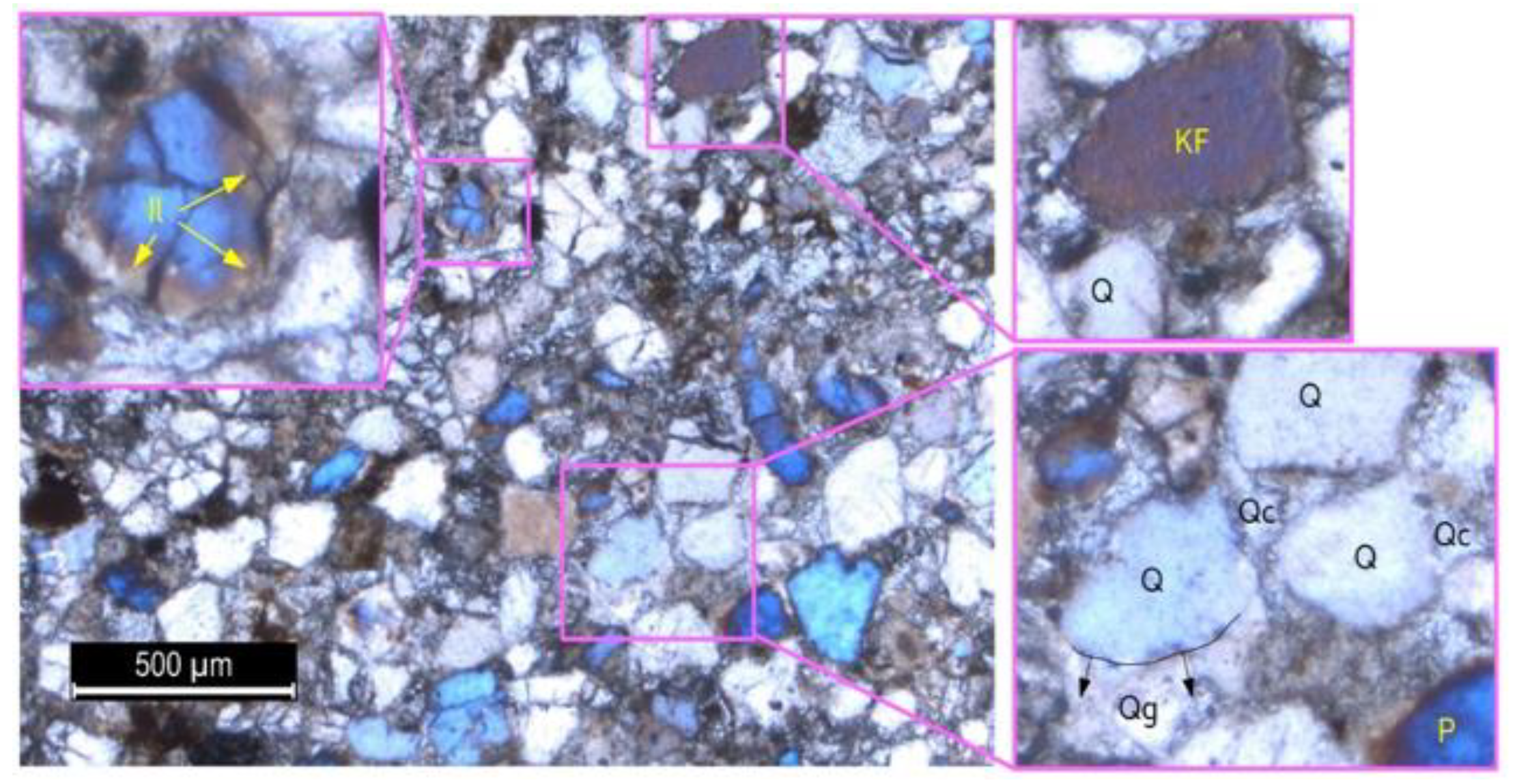
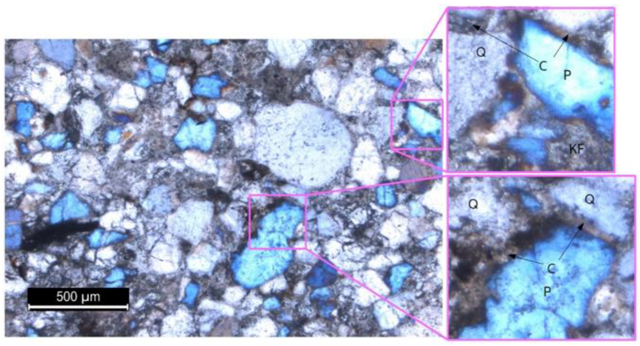
Some thin sections of the Belait and Temburong Formations from the L1, L3, L5, L6, and L8 outcrops were prepared and observed under a polarized microscope to identify the different petrographical parameters, such as the texture, facies, diagenesis, visual porosity, estimation, and pore size distribution analysis (Figure 10, Figure 11, Figure 12, Figure 13, Figure 14, Figure 15, Figure 16 and Figure 17)⁠. The identification of the different sedimentology and mineralogy features is based on their optical properties. The clay types were later identified based on the Th/K ratio. The samples have shown various sedimentological and diagenetic features, including tight argillaceous features, moderately sorted sandstone with kaolinite filling textures, quartz overgrowth, illite pore-lining, and chlorite grain coating. The diagenetic features were studied from three thin sections, representing the three main facies. The thin sections were explicitly studied to identify the authigenic clay minerals. L1-01 represents the fine facies of the Belait Formation, L3-01 represents the Temburong tight sandstone facies, and L5-01 shows the coarse sandstone facies of the Belait Formation, depicted in Figure 15, Figure 16 and Figure 17, respectively. The different morphologies of authigenic clay minerals were identified under a microscope, including kaolinite cavity filling, illite pore lining, and chlorite grain coating. Sample L1-01, which is dominated by kaolinite and has a poor permeability, shows kaolinite pore filling domination under a microscope (Figure 12). Sample L3-01, which is characterized by the domination of mixed-layer clay and has a poor permeability, shows pore-filling kaolinite, quartz cement, quartz overgrowth, and illite pore lining clearly, as shown in Figure 13. Sample L5-01, which represents chlorite domination and has good permeability values, shows a high percentage of chlorite coats and a small amount of kaolinite filling, with clear pore spaces in the thin section (Figure 14).

4.1.3. Visual Porosity

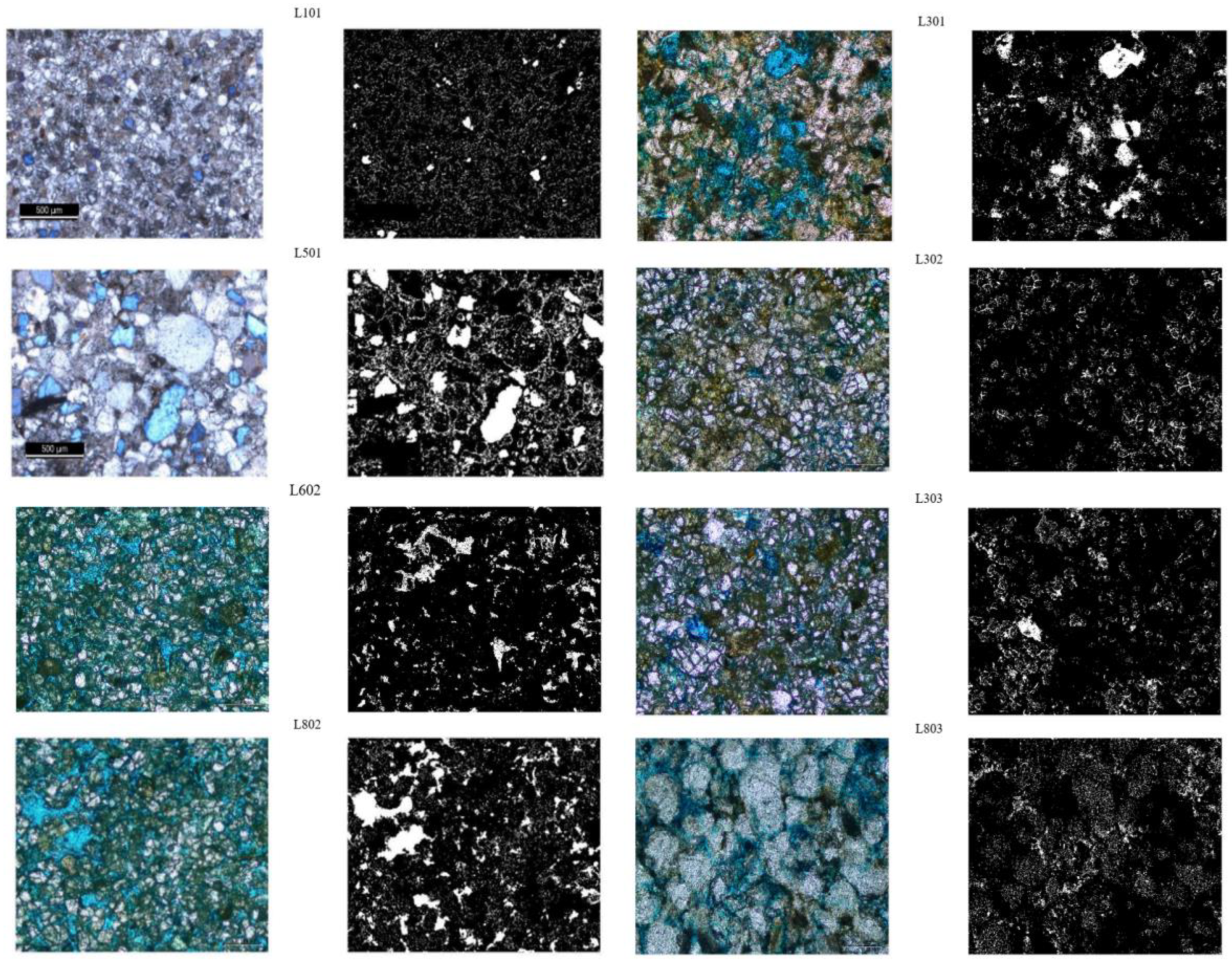
The porosity results showed a wide range of values for the thin sections (Figure 18). An image region analyzer was later used to calculate the number of pores and their equivalent diameters. Depending on the analysis of the equivalent diameters, the porosity was classified into macro- and micropores from the visual porosity images. The samples showed a range between 23.5 and 7.3 % of the porosity studied samples (Table 2).

4.1.4. Grain Size Analysis

The analysis of the different grain sizes shows the domination of very fine-grained sand in all of the samples. None of the analyzed samples showed any grain size greater than a medium-grained sand size. The samples were classified based on the significant grain sizes percentages of sand, silt, and mud sizes. The samples were classified as sandstone in the samples with mud size percentages of less than 10%, and muddy sandstone in the samples with mud size percentages of more than 10%.

4.2. Petrophysical Parameters

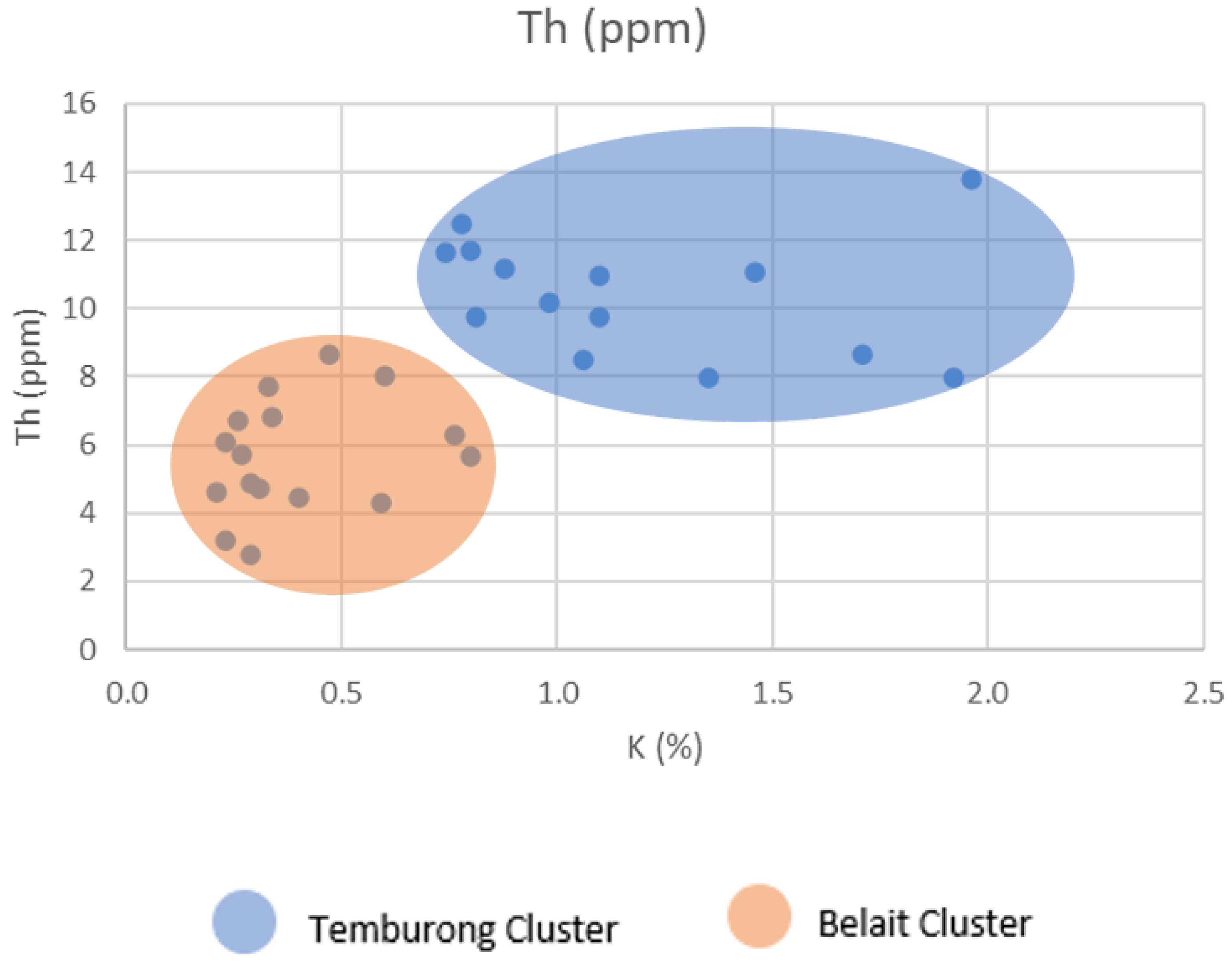
Air permeability measurements were collected from the spots depending on their lithological aspects, from L1, L3, L4, L5, L6, L6B, L7, and L8, to measure their permeability. All of the intervals from L101 and L501 were included. The same spots were chosen to collect SGR. The identification of the clay mineral types was performed to better understand the presence of the clay. For this purpose, the thorium/potassium (ppm/%) cross-plot was used, according to [22]⁠. The Th/K cross-plot was plotted, which was very helpful in understanding the clay mineral type distribution of the studied outcrops and intervals (Figure 19).

5. Discussion

The petrography and petrophysics of the studied outcrops and intervals are discussed in the following section, based on the preliminary data collected. The field observations and the thin sections in this study were used to outline the main features of the outcrops. The thin sections and image analysis were used to identify the porosity and pore size distribution, with geostatistics understanding the relations between the different facies and porosity distribution. The pore size distribution has shown a notable difference between the Temburong and Belait selected samples, with a better quality for Belait and pore space ranges of about 5 to 14 micrometers. Additionally, there was a range of about 2 to 5 micrometers for Temburong. The Belait Formation samples L601, L802, and L803 show a more comprehensive range of porosity, with a lesser microporosity percentage.
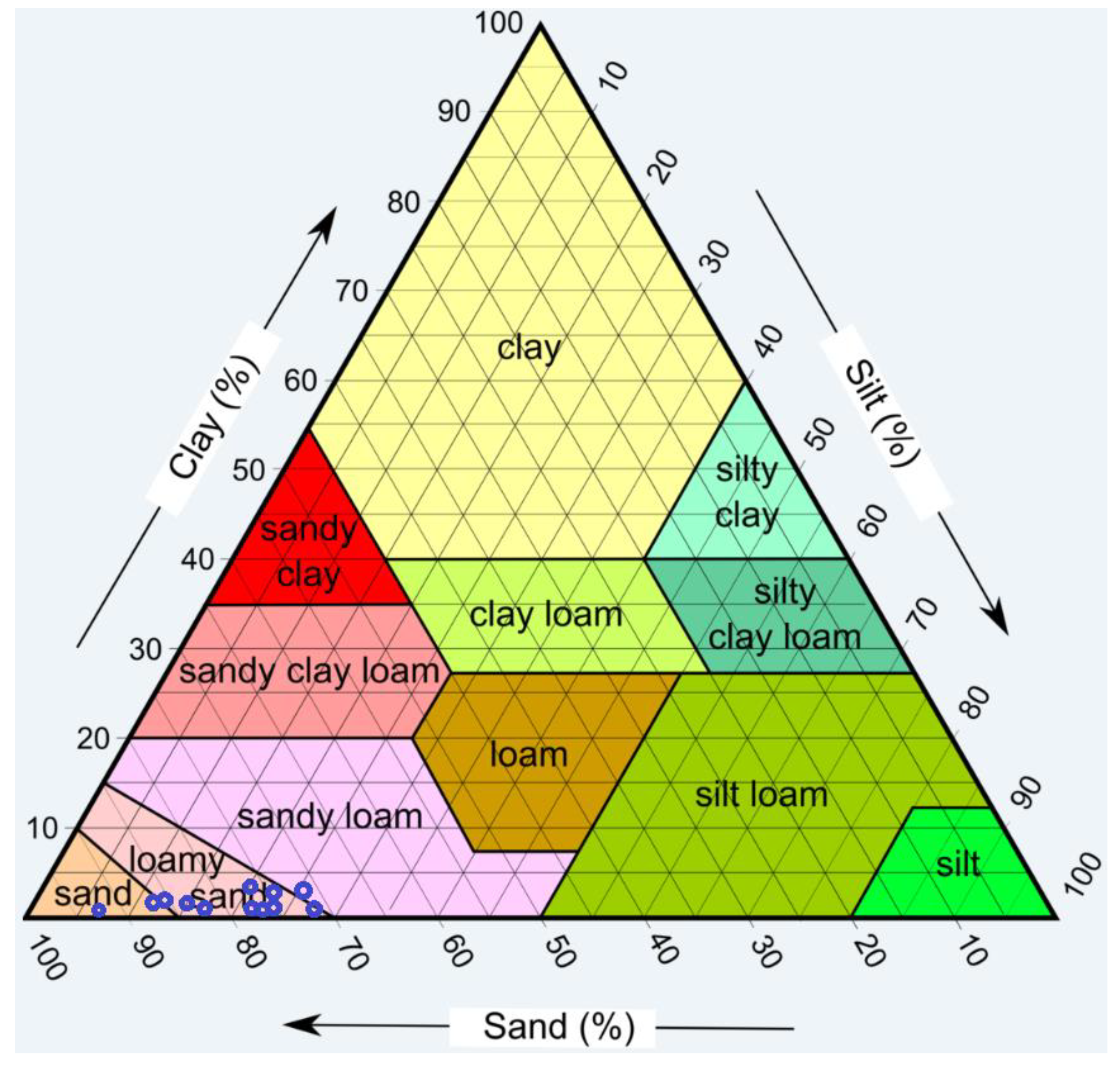
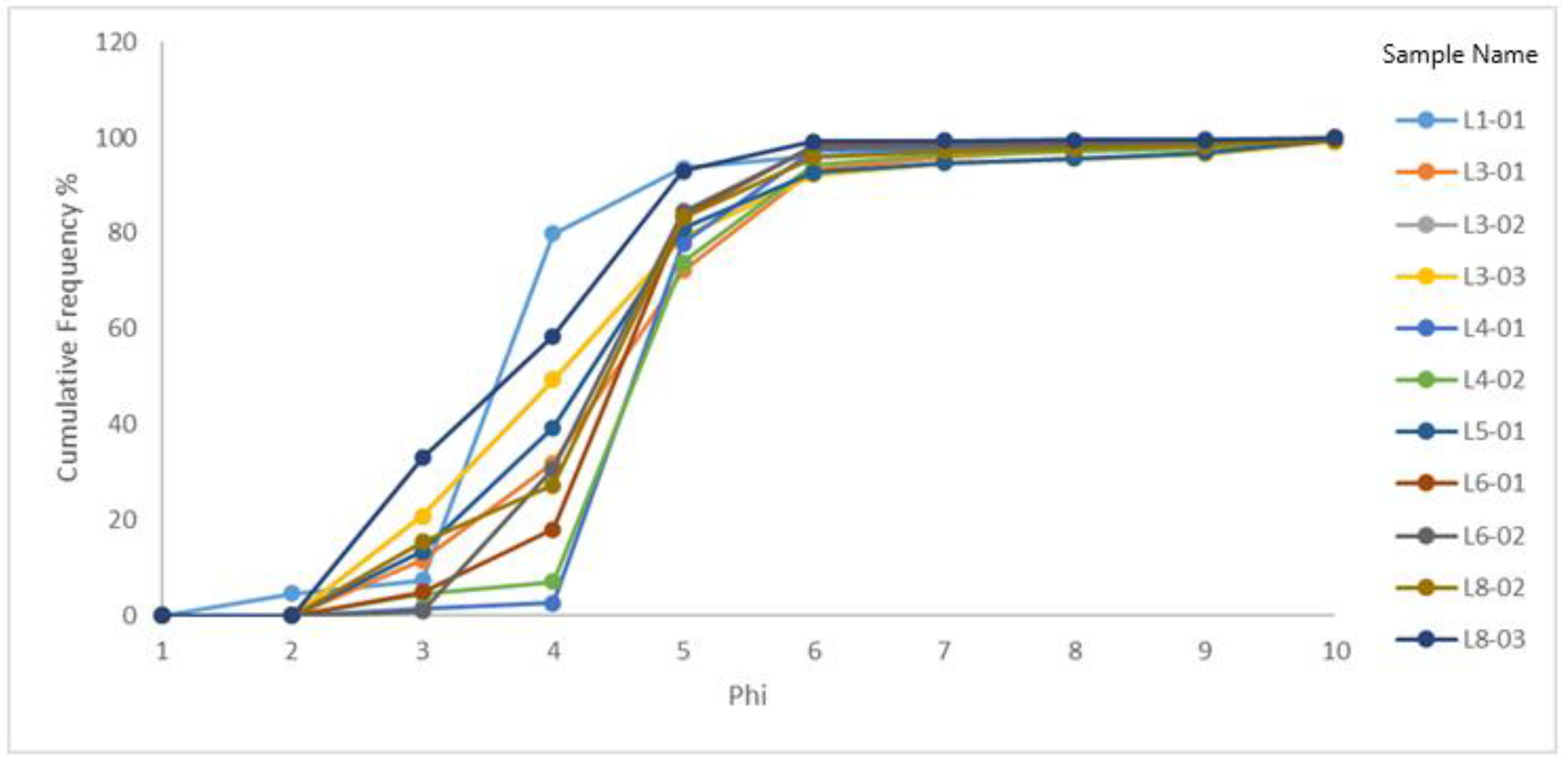
In contrast, the Temburong Formation’s samples show a tight porosity range with a higher microporosity percentage. The outliers reached more than 30 points in some of the samples presented above, which may not be a considerable number, as the total pores identified exceeded 750 pores per image. Hence, the outliers, especially in L301, L302, and L303, are less than 5% (Figure 20). The analysis of the different grain sizes in Table 3 in the results section shows the domination of a very fine sand size in most of the samples. Based on the percentages of sand, silt, and clay, the USDA classification revealed that all of the analyzed samples are classified as sand or loamy sands (Figure 21). None of the analyzed samples showed any presence of any grain size greater than a medium sand size (Figure 22). The clay size ranged between 0.36 to 2.72 percent of the total weight. The grain size cumulative frequency curves of the studied samples are presented.
According to the curves in Figure 22, the primary grain size that dominated in the samples is the size between the sieves of the (0.075) mm and (0.125) mm sizes, or the Phi values of four and three, respectively, with a percentage range of 50–90% of the sizes. This result shows the domination of very fine sand in most of the samples. The samples showed a range of sorting, from poorly to moderately well-sorted samples. The Crocker and Temburong Formation samples all showed poor sorting, while most of the Belait Formation samples showed a moderate sorting, reflecting the nature of the deposition of the deep marine and fluvio-marine depositional environments.
The graphic skewness values showed different values between the symmetry and the positive and negative skewness (Table 4). The samples from the same outcrops of the Belait Formation showed some coherence, like L4 and L6, while the samples from the Crocker and Temburong Formation outcrops did not show the same coherence, which may lead to less diagenetic effects on the Belait Formation. The narrow range of the grain size and the poor sorting of most of the examined samples explains the domination of microporosity, as the pores may be found in the areas between the grains, and since the grains ranged from fine to very fine grain sizes, the in-between spaces tended to be in micro-scale, thus forming more micropores.
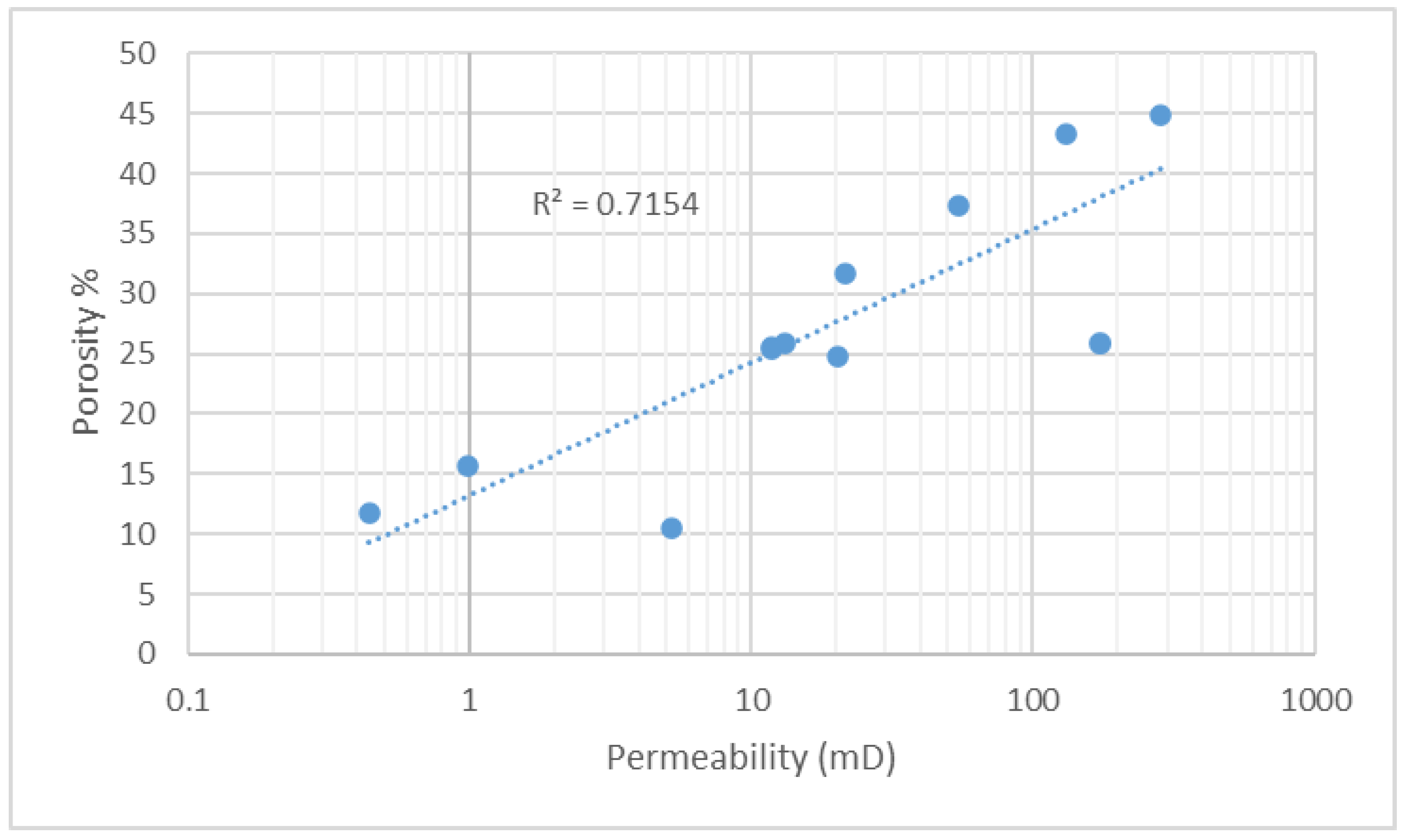
The data from the grain size analysis were integrated with the microporosity data from the visual image analysis to understand the effect of the different grain sizes on the micropores. It was evident from the results of this study that the focus was concentrated on the finer fraction of the clastic rocks. The figures below illustrate the relationship between the microporosity in the sample and the mud grain size. The calculated correlation coefficient in Figure 23 between the permeability and porosity is 0.7. In Figure 24, the scatter plot shows a strong relationship between the presence of microporosity in clastic rocks and the mud percentage with R2 = 0.703. This relationship can describe the role of the silt and clay grain sizes on microporosity.
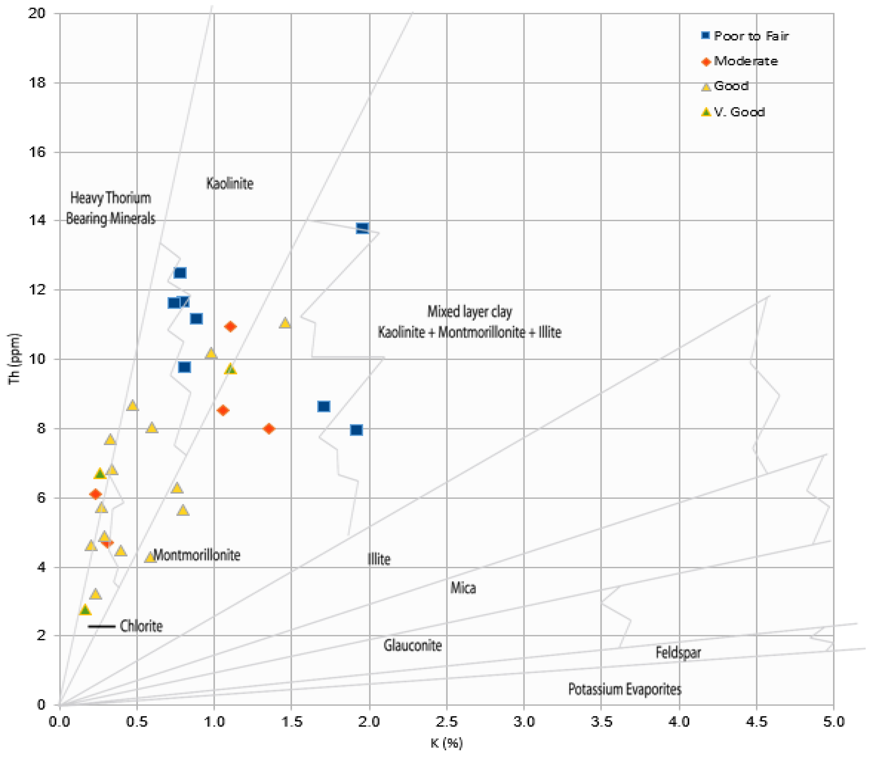
The Th/K cross-plot values were combined with the permeability at different levels to understand the effect of the different clay minerals on the permeability. The cross-plot between the permeability qualities is classified into four levels, from poor to fair to very good permeability. The clay minerals content obtained from SGR explained the role of each clay type on the permeability (Figure 25).
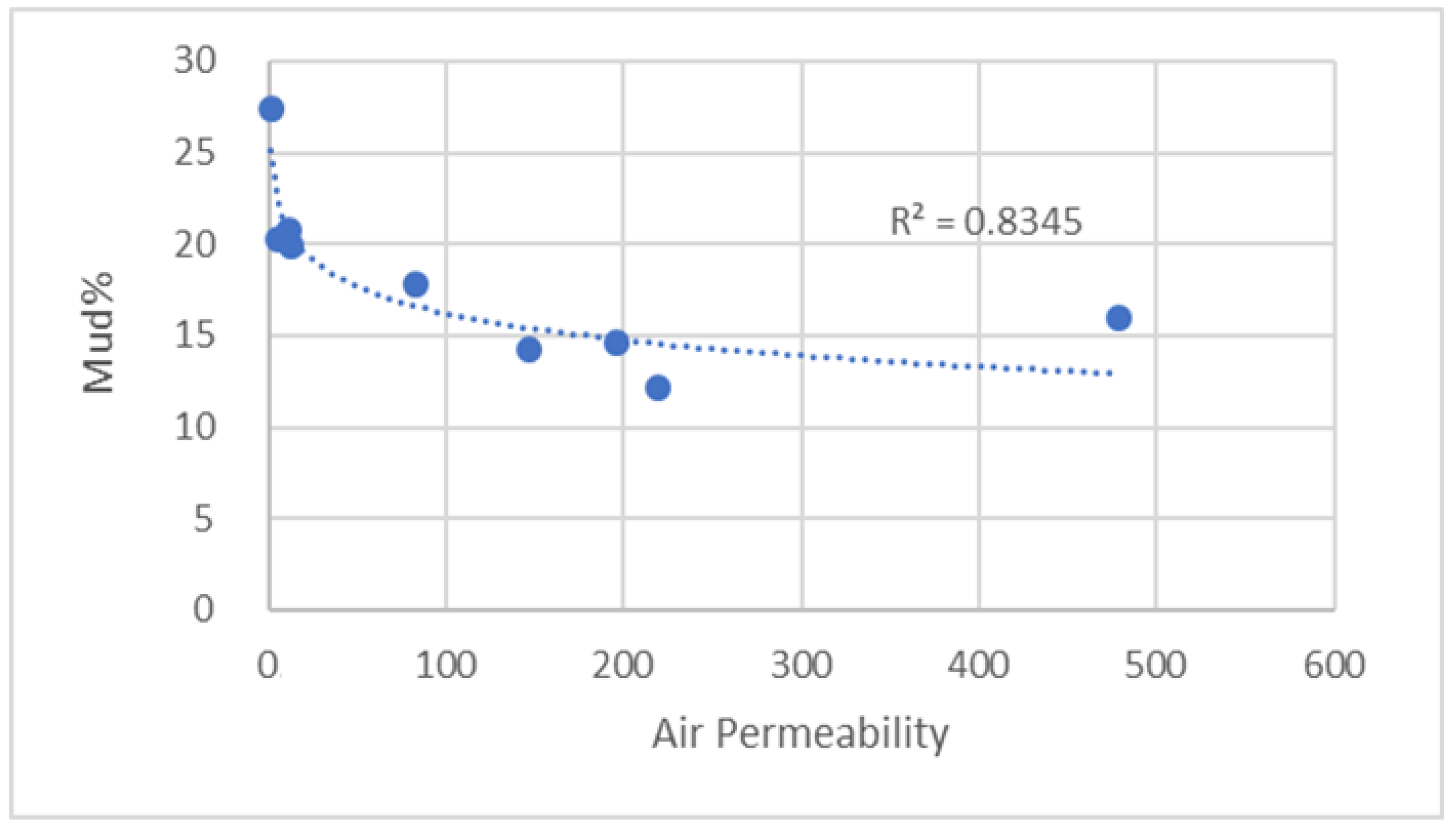
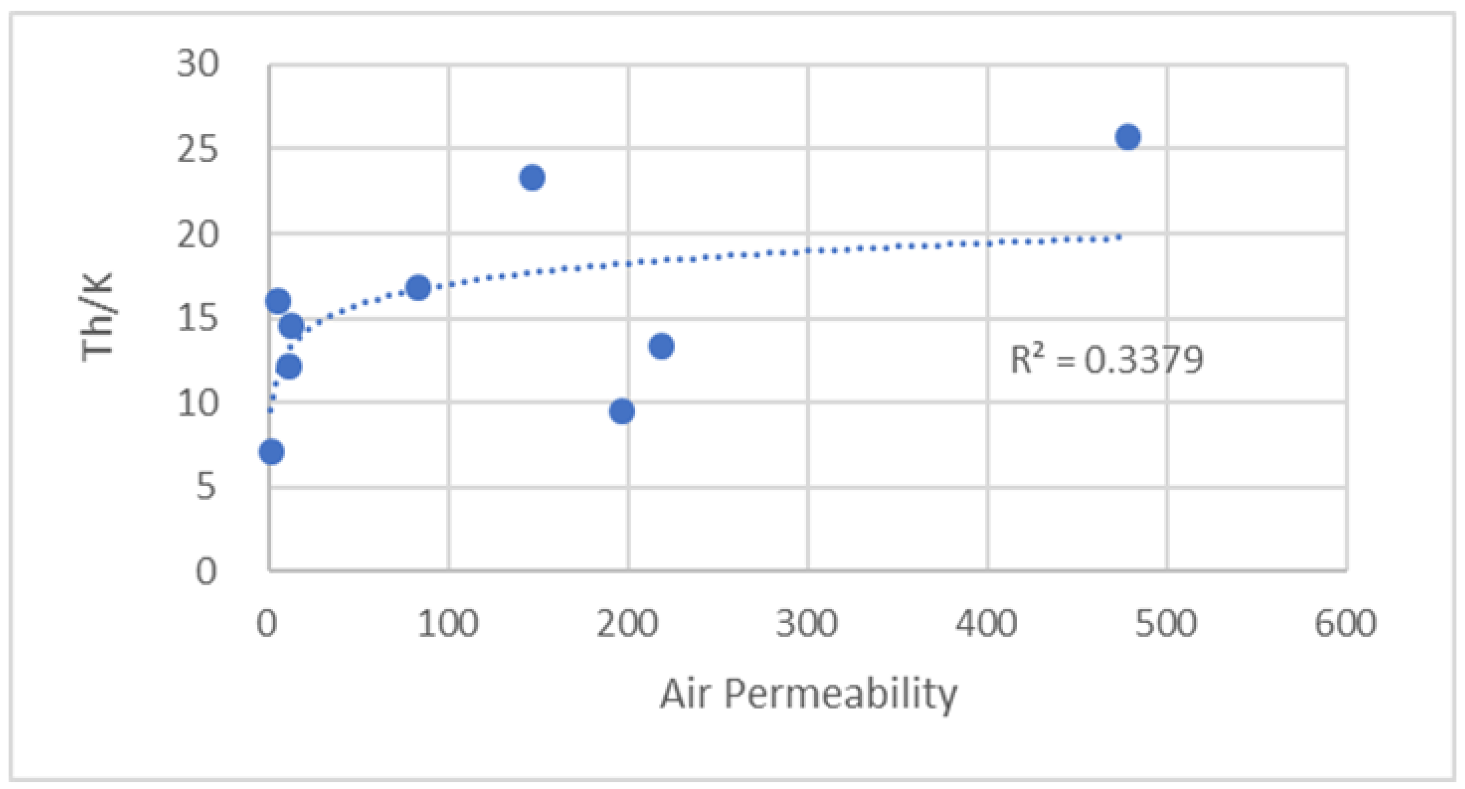
From the Th/K cross-plot, it is evident that chlorite and montmorillonite have preserved permeability against porosity, reducing diagenetic processes such as pore filling, quartz cement, and the overgrowth of quartz. However, kaolinite and mixed-layer clay can be responsible for reducing the permeability. Integrating the sieve analysis with the air permeability and spectral gamma-ray results has shown the different effects of mud size percentage, including silt and clay sizes, on the permeability and Th/K. In Figure 26, the coefficient of determination (R2) showed a strong negative relationship, with a value of (0.8345) between the percentage of the clay in the included sample and the permeability measured by the air permeameter. On the other hand, the value of (R2) equal to (0.3379), calculated in Figure 27, shows a fragile relationship between the air permeability measurements and the Th/K ratio, confirming that the presence of different types of clays has different effects on permeability.

6. Conclusions

The present research aimed to study the sedimentological features of selected outcrops from Labuan Island, Malaysia, as well as the development and evolution of the diagenetic factors that affect clastic reservoir rocks. The geographical location of Labuan is a crucial link between Sabah’s onshore and offshore sectors. It was determined that the porosity distribution in the samples of the parent rock was affected by the presence of diagenetic clay minerals, their type based on the SGR, and their influence on the type of porosity. It was established that clay minerals have a significant effect on the quality of clastic reservoirs in an area, so several methods were used to evaluate this impact. In this paper, it has been shown that the results derived from field observations, measurements, and sampling, combined with a thin section analysis, a grain size analysis, an image analysis, and geostatistical methods, have played an essential role in evaluating the impact of clay minerals on reservoir quality. In the grain size analysis, the samples from Labuan Island showed very fine sand as the dominant grain size. Sandstone and loamy sandstone are the two classes represented. The air permeability results, obtained using spectral gamma-ray measurements, have shown a strong correlation between the permeability level and the clay content. It was found that the chlorite and montmorillonite coatings were both effective in preserving permeability. However, kaolinite pore filling had a destructive impact on permeability. The Belait Formation has shown a better permeability and porosity, while Temburong had poor quality in most of the analyzed samples. In combination with the grain size analysis, the visible porosity distribution results showed a strong correlation between the mud grain size distribution and microporosity distribution. The reservoirs of the offshore Belait Formation (Stage IV) are expected to have a better quality than the reservoirs of the offshore Temburong Formation (Stage II).

Author Contributions

Conceptualization, M.R., H.T.; methodology, M.R.; software, M.R.; validation, H.T.; formal analysis, M.R.; investigation, M.R.; writing—original draft preparation, M.R.; writing—review and editing, H.T., M.R., O.R. and J.D.; visualization, M.R.; supervision, H.T.; funding acquisition, J.D. and H.T. All authors have read and agreed to the published version of the manuscript.

Funding

This research was funded by YUTP grant (015LC0-060) and (015LC0-325).

Institutional Review Board Statement

Not applicable.

Informed Consent Statement

Not applicable.

Data Availability Statement

Available upon request.

Acknowledgments

The authors would like to acknowledge the financial support from the Institute of Hydrocarbon Recovery, Universiti Teknologi PETRONAS.

Conflicts of Interest

The authors declare no conflict of interest, including personal circumstances or interests that may be perceived as inappropriately influencing the representation or interpretation of the reported research results.

References

  1. Nadeau, P.H. An experimental study of the effects of diagenetic clay minerals on reservoir sands. Clays Clay Miner. 1998, 46, 1998. [Google Scholar] [CrossRef]
  2. Islam, M.A. Diagenesis and reservoir quality of Bhuban sandstones (Neogene), Titas Gas Field, Bengal Basin, Bangladesh. J. Asian Earth Sci. 2009, 35, 89–100. [Google Scholar] [CrossRef]
  3. Morad, S.; Al-Ramadan, K.; Ketzer, J.M.; De Ros, L.F. The impact of diagenesis on the heterogeneity of sandstone reservoirs: A review of the role of depositional facies and sequence stratigraphy. Am. Assoc. Pet. Geol. Bull. 2010, 94, 1267–1309. [Google Scholar] [CrossRef]
  4. Henares, S.; Caracciolo, L.; Cultrone, G.; Fernández, J.; Viseras, C. The role of diagenesis and depositional facies on pore system evolution in a Triassic outcrop analogue (SE Spain). Mar. Pet. Geol. 2014, 51, 136–151. [Google Scholar] [CrossRef]
  5. Ajdukiewicz, J.M.; Lander, R.H. Sandstone reservoir quality prediction: The state of the art. Am. Assoc. Pet. Geol. Bull. 2010, 94, 1083–1091. [Google Scholar] [CrossRef]
  6. Madon, M. The stratigraphy of northern Labuan, NW Sabah Basin, East Malaysia. Bull. Geol. Soc. Malaysia 1994, 36, 19–30. [Google Scholar]
  7. Zhang, G.; Qu, H.; Liu, S.; Xie, X.; Zhao, Z.; Shen, H. Hydrocarbon accumulation in the deep waters of South China Sea controlled by the tectonic cycles of marginal sea basins. Pet. Res. 2016, 1, 39–52. [Google Scholar] [CrossRef]
  8. Zhou, D.; Yao, B. Tectonics and sedimentary basins of the South China Sea: Challenges and progresses. J. Earth Sci. 2009, 20, 1–12. [Google Scholar] [CrossRef]
  9. Nazaruddin, D.A.; Mansor, H.E.; Wali, S.S.A.S. Geoheritage of labuan island. Bull. Geol. Soc. Malaysia 2016, 62, 117–129. [Google Scholar] [CrossRef]
  10. Santika, T.; Wilson, K.A.; Meijaard, E.; Ancrenaz, M. The power of mixed survey methodologies for detecting decline of the Bornean orangutan. bioRxiv 2019, 775064. [Google Scholar] [CrossRef] [Green Version]
  11. Hasiah, A.W.; Lee, C.P.; Gou, P.; Shuib, M.K.; Ng, T.F.; Albaghdady, A.A.; Mislan, M.F.; Mustapha, K.A. Coal-bearing strata of Labuan: Mode of occurrences, organic petrographic characteristics and stratigraphic associations. J. Asian Earth Sci. 2013, 76, 334–345. [Google Scholar] [CrossRef]
  12. Lukie, T.D.; Balaguru, A. A Sedimentologic and Petrographic Perspective of the Miocene Stage IVA from the Klias Peninsula to Labuan Island. In Proceedings of the PGCE 2012, Kuala Lumpur, Malaysia, 23–24 April 2012. [Google Scholar]
  13. Abidin, Z. Labuan Field Trip Report; University of Malaya: Kuala Lumpur, Malaysia, 2019. [Google Scholar]
  14. Bakar, B.; Tahir, S.H.; Asis, J. Deep marine benthic foraminiferal from temburong formation in labuan island. Earth Sci. Malaysia 2017, 1, 17–22. [Google Scholar] [CrossRef]
  15. Hutchinson, C.S. Geology of North-West Borneo: Sarawak, Brunei and Sabah; Elsevier: Amsterdam, The Netherlands, 2005; Volume 52. [Google Scholar]
  16. Madon, M. Sedimentological aspects of the Temburong and Belait Formations, Labuan (offshore west Sabah, Malaysia). Bull. Geol. Soc. Malaysia 1997, 41, 61–84. [Google Scholar] [CrossRef]
  17. Som, M.; Kadir, M.F.B.A.; Syareena, S.; Ali, M.; Jirin, S.; Sulaiman, W.M.K.A.W.; Mohsin, N.; Salwani, S. Labuan Outcrop Revisited: New Findings on Belait formation Facies Evolution (slides). In Proceedings of the Petroleum Geology Conference and Exhibition 2011, Kuala Lumpur, Malaysia, 7–8 March 2011. [Google Scholar]
  18. Risha, M.; Douraghi, J. Impact of Clay mineral type on sandstone permeability based on field investigations: Case study on Labuan island, Malaysia. J. Phys. Conf. Ser. 2021, 1818, 12091. [Google Scholar] [CrossRef]
  19. Folk, R.L.; Ward, W.C. Brazos River bar [Texas]; a study in the significance of grain size parameters. J. Sediment. Res. 1957, 27, 3–26. [Google Scholar] [CrossRef]
  20. Magnabosco, C.; Braathen, A.; Ogata, K. Permeability model of tight reservoir sandstones combining core-plug and Miniperm analysis of drillcore; Longyearbyen CO. Nor. J. Geol. 2014, 94, 189–200. [Google Scholar]
  21. Radulescu, I.; Stochici, R.; Calin, M.R.; Visan, M.; Diacopolos, C.; Grigoras, G. Experimental characterization of an in-situ spectro-tracer used in geophysical explorations. Rom. Reports Phys. 2020, 72, 709. [Google Scholar]
  22. Glover, P.W.J. Petrophysics; University of Aberdeen: Aberdeen, UK, 2000. [Google Scholar]
  23. USDA (United States Department of Agriculture). Soil Survey Manual-Handbook; U.S. Department of Agriculture: Washington, DC, USA, 2017; No. 18.
  24. Nuţu-Dragomir, M.L.; Chitea, F.; Stochici, R.; Diacopolos, C. A new approach concerning active faults in subcarpathian nappe (EAST CARPATHIANS). In Proceedings of the Geoscience 2017, 2nd Symposium of SGAR, Bucharest, Romania, 24 November 2017. [Google Scholar]
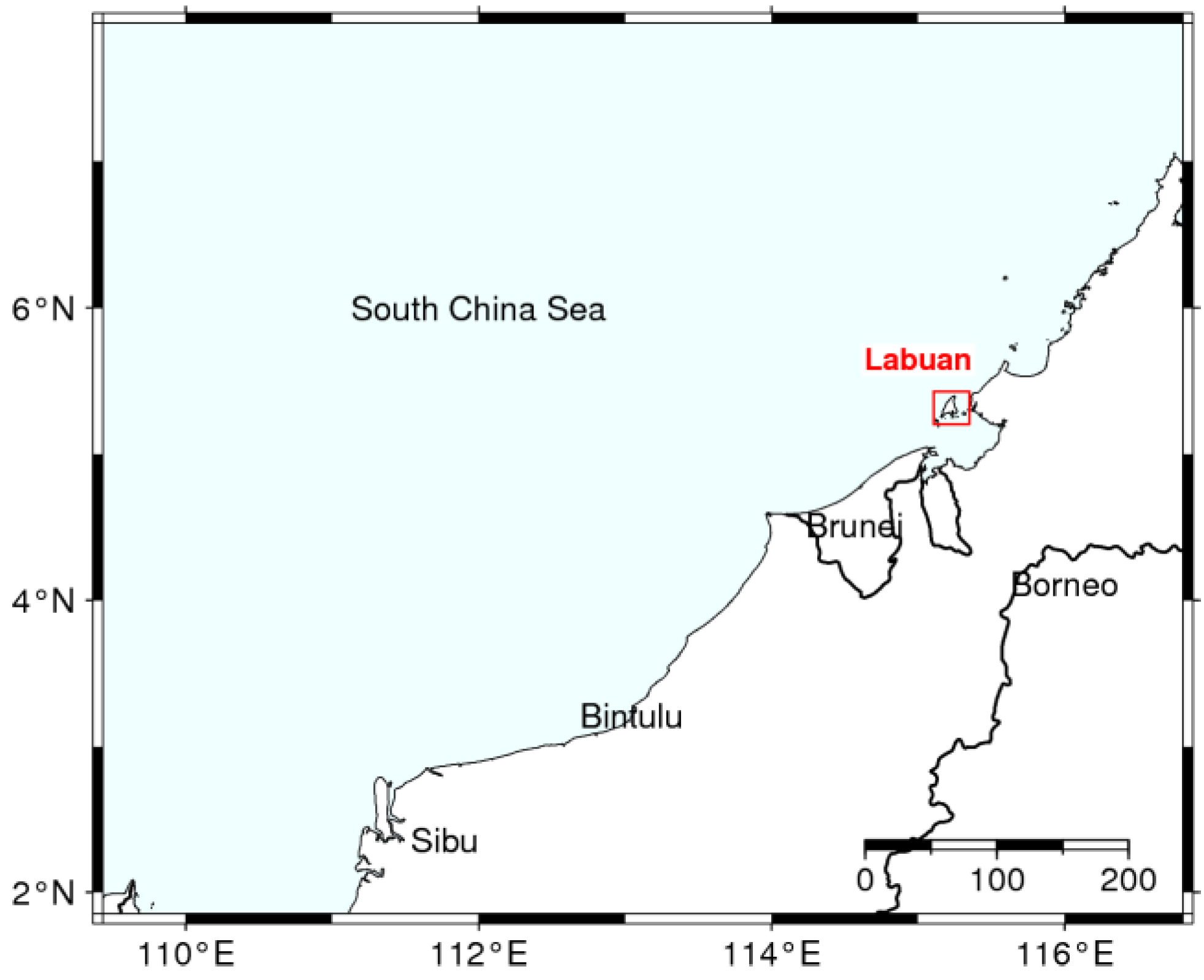
Figure 1. A locational map of Labuan Island in relation to the South China Sea and Borneo.
Applsci 13 03427 g001
Figure 2. (A) The upper Belait Formation sandstone with coal intercalations, (B) the interbedded fine-grained sandstone of the Temburong Formation, and (C) the lower Belait Formation massive sandstone.
Applsci 13 03427 g002
Figure 3. Labuan geological map, showing the distribution of the four major formations on the island [18].
Applsci 13 03427 g003
Figure 4. Image analysis workflow diagram for identifying pore spaces in thin sections. The first step is identifying pore spaces based on the color difference using thin sections, the second step is to separate the blue color, the third step is to create a binary images with the 0 value for pore spaces and the 1 value for minerals, and the last step was to classify the clusters of the 0 value spots to calculate their areas, and axes lengths.
Applsci 13 03427 g004
Figure 5. The hydrometer test setup for the finer fraction of the samples.
Applsci 13 03427 g005
Figure 6. Measuring air permeability using the Tinyperm II portable permeameter.
Applsci 13 03427 g006
Figure 7. The locations of the studied exposed outcrops on Labuan Island (red dots).
Applsci 13 03427 g007
Figure 8. The sedimentary log of the L1 outcrop, including lithology thicknesses, texture, SGR values, and shale volume.
Applsci 13 03427 g008
Figure 9. The sedimentary log of the L5 outcrop, including lithology thicknesses, texture, SGR values, and shale volume.
Applsci 13 03427 g009
Figure 10. Textural and compositional features of L301 Temburong.
Applsci 13 03427 g010
Figure 11. Textural and compositional features of L302 Temburong.
Applsci 13 03427 g011
Figure 12. Textural and compositional features of L303 Temburong.
Applsci 13 03427 g012
Figure 13. Textural and compositional features of L802 Belait.
Applsci 13 03427 g013
Figure 14. Textural and compositional features of L803 Belait.
Applsci 13 03427 g014
Figure 15. Textural and compositional features of L1-01. (Q) Quartz, (P) pore space, and (KF) kaolinite filling.
Applsci 13 03427 g015
Figure 16. Textural and compositional features of L3-01. (Q) Quartz, (P) pore space, (KF) kaolinite filling, (Qg) quartz overgrowth, (Qc) quartz cement, and (Il) illite lining.
Applsci 13 03427 g016
Figure 17. Textural and compositional features of L5-01. (Q) Quartz, (P) pore space, (C) chlorite grain coating, and (KF) kaolinite filling.
Applsci 13 03427 g017
Figure 18. Thin sections and their binary components are based on blue epoxy color threshold.
Applsci 13 03427 g018
Figure 19. The thorium/potassium cross-plot.
Applsci 13 03427 g019
Figure 20. A box plot of 6 samples from Temburong and Belait Formations.
Applsci 13 03427 g020
Figure 21. USDA sediment classification [23]. Most of the samples fall into the sand and the loamy sand ranges, mainly controlled by the silt percentage in the sample.
Applsci 13 03427 g021
Figure 22. Grain size cumulative frequency curves showing the range of grain size distribution of the studied samples.
Applsci 13 03427 g022
Figure 23. Scatter plot of permeability and porosity.
Applsci 13 03427 g023
Figure 24. Scatter plot of visual microporosity and mud size.
Applsci 13 03427 g024
Figure 25. Thorium/potassium cross-plot showing the different classes of permeability and clay minerals type associated with them (modified after [24]).
Applsci 13 03427 g025
Figure 26. A scatter plot showing the relations of mud grain size percentage and air permeability.
Applsci 13 03427 g026
Figure 27. A scatter plot showing the relations of the Th/K ratio and air permeability.
Applsci 13 03427 g027
Table 1. List of sieves and their opening diameter in (mm).
SieveSieve Opening (mm)
44.75
82.36
161.18
404.25
500.3
1000.15
2000.075
Pan---
Table 2. The porosity in percent (%) for the blue-impregnated thin sections.
SampleL101L301L302L303L501L602L802L803
Porosity10.218.87.311.323.518.521.78.1
Table 3. Grain size distribution data.
Size* C. S* M. S* F. S* V. F. S* C. Si* M. Si* F. Si* V. F. Si* C
Phi123456789
L10104.607.4579.8893.7096.1497.5698.5899.63
L301011.5832.0072.2593.3695.7997.4098.5699.13
L302020.8149.3879.1992.2694.7795.6096.5399.25
L30309.7235.3478.5795.6997.5497.9198.5699.59
L40101.522.5677.8697.2897.7097.9198.3399.71
L40204.417.1173.9594.3596.4497.1197.6199.96
L501013.3839.3281.0292.6794.7795.6096.8699.58
L60104.8918.0883.4898.3398.7498.9598.9599.96
L60200.9130.7184.4697.9198.4998.5898.7499.79
L802015.3827.3383.3196.0197.2297.7198.2699.51
L803033.0258.4993.0299.2299.3699.4399.5799.93
* C. S = coarse sand, M. S = medium sand, F. S = fine sand, V. F. S = very fine sand, C. Si = coarse silt, M. S = medium silt, F. Si = fine silt, V. F. Si = very fine silt, and C = clay.
Table 4. Folk & Ward grain size statistical parameters measured from samples frequency curves [19].
SampleSTDVSkewnessKurtosisSortingSkewness
L1010.7295450.104.10Moderately sortedNear symmetrical
L3011.221212−0.032.40Poorly sortedNear symmetrical
L3021.4272730.162.46Poorly sortedPositive skewed (coarse)
L3031.055303−0.072.87Poorly sortedNear symmetrical
L4010.5575760.372.32Moderately well-sortedPositive skewed (coarse)
L4020.8553030.243.59Moderately sortedPositive skewed (coarse)
L5011.246970.043.77Poorly sortedNear symmetrical
L6010.749242−0.073.83Moderately sortedNear symmetrical
L6020.768939−0.062.66Moderately sortedNear symmetrical
L8021.070455−0.223.69Poorly sortedNegative skewed (fine)
L8031.1106060.121.68Poorly sortedPositive skewed (coarse)
Disclaimer/Publisher’s Note: The statements, opinions and data contained in all publications are solely those of the individual author(s) and contributor(s) and not of MDPI and/or the editor(s). MDPI and/or the editor(s) disclaim responsibility for any injury to people or property resulting from any ideas, methods, instructions or products referred to in the content.