Article

Towards Sustainable Regional Planning: Potential of Commuter Rail in the Madrid Urban Region

by
Eloy Solís
1,
Borja Ruiz-Apilánez
1,
Amparo Moyano
2,
Inmaculada Mohíno
3 and
José María Coronado
2,*
1
Departamento de Ingeniería Civil y de la Edificación, Universidad de Castilla-La Mancha, 45071 Toledo, Spain
2
Departamento de Ingeniería Civil y de la Edificación, Universidad de Castilla-La Mancha, 13071 Ciudad Real, Spain
3
Departamento de Urbanismo y Ordenación del Territorio, Universidad Politécnica de Madrid, 28003 Madrid, Spain
*
Author to whom correspondence should be addressed.
Appl. Sci. 2023, 13(6), 3953; https://doi.org/10.3390/app13063953
Submission received: 26 December 2022 / Revised: 14 March 2023 / Accepted: 16 March 2023 / Published: 20 March 2023
(This article belongs to the Special Issue Current Research and Future Development for Sustainable Cities)

Abstract

:

Featured Application

Regional planning and commuter rail development towards sustainable planning.

Abstract

In the extensive framework of the historiography on the relationship between railroads and cities that began in the second half of the 19th century, a new phase of thought and action emerged from the 1980s, driven by a transport-oriented development approach and the node–place model within the paradigms of New Urbanism and sustainable urbanism, respectively. This highlights the need to integrate railway planning and urban and territorial planning to take advantage of the development potential of the urban areas surrounding railway stations. In this context, a subject rarely analyzed in Spain is the urban areas around commuter railway stations and the opportunity they represent to rethink growth and development on an urban and metropolitan scale. This study explores and shows the roles that municipalities with commuter stations and their surrounding areas play and could play as a basis for leading an urban and territorial strategy based on a polycentric model in favor of more sustainable mobility and development in the Madrid urban region.

1. Introduction

The reflections and actions related to the interrelation between rail public transport networks and regional planning are not new. They have their roots in proposals from the late nineteenth century, such as Arturo Soria’s Linear City (1892) or Ebenezer Howard’s Garden City (1899). However, since the 1990s, new theoretical frameworks have been promulgated, such as transit-oriented development (TOD) [1] and the node–place model (NPM) [2]. These propose that to take advantage of the development potential offered by proximity to public transport and the accessibility to other spaces that it generates, it is necessary to (i) overcome the dissociation between rail policies and urban policies; (ii) promote a (re)management and (re)design of the urban areas around stations based on density, compactness, diversity of uses and functions and adapt public space in favour of active mobility and its connection with different modes of public transportation; and (iii) improve transport infrastructure and services.
This type of approach arises as a response to negative effects on the environment, health and socioeconomic development that are derived from contemporary forms of production in cities, characterized by dispersion, low density, low compactness, social and functional specialization, and high dependence on private vehicles [3]. The lack of coordination among transport planning, urban planning and land management is the result of a lack of common criteria and different competencies and standards that have resulted in great difficulty in negotiating and reaching agreements between institutions at various scales [4], although the coordination between planning and transportation is continuously reclaimed.
Based on these paradigms and approaches, we propose a new reading on a regional scale, applying it to the case of the regional area of Madrid and the commuter rail network. The regional planning thus oriented results in a more polycentric and sustainable development model, both regarding the occupation of the territory and the mobility generated.
At the European level, the idea of taking advantage of the development potential of the areas around public transport stations, mainly railway stations, has been implemented, highlighting high-speed rail stations [5]. In the Spanish sphere, although there are quite a few studies that treat and highlight the role of the railway as one of the most incisive elements of territorial and urban organization [6,7], there is a scarcity of studies that evaluate the dynamics of growth and development around railway stations as well as a predominance of analyses linked to high-speed rail stations [8,9]. In Spain, there is little background regarding case studies that incorporate neither TOD nor NPM approaches (Table 1).
These studies show that (i) there is a recognition of the influence of urban form (density, compactness, mix of uses and functions, and design of public space) in the modes of travel, and, consequently, greater coordination is demanded between transport planning and urban planning; (ii) from the methodological point of view, there is no established systematic procedure oriented to the study of urban areas around stations to promote more sustainable urban spaces; this may be due to the still incipient application of these approaches, the different approaches and analyses that can be carried out on the interrelation between the railway station and its surroundings, and the particular geographical features of each place; and (iii) there is a lack of a thorough analysis of the urban areas of non-high-speed railway stations both in metropolitan contexts and in rural areas—such is the case for the commuter rail in the Madrid urban region.
In the context of the Spanish case, the proximity to a railway station and the accessibility that the train provides to other urban and metropolitan spaces can serve as strategic tools to develop or strengthen locations in terms of centrality and promote more sustainable mobility. From this perspective, we propose a new interpretation and analysis of territorial occupation based on the commuter rail network and the surroundings of stations. The main objective is to promote the transition from a metropolitan mobility and occupation model based on private motorization and dispersal towards another model organized in new polarities or centralities and more sustainable mobility patterns. The regional urban area of Madrid serves as the location for our case study and where we apply the model. Regarding planning and mobility, this urban region is characterized by three main features.
First, there is a predominance of urban plans marked by developmental approaches and dominated by a narrow municipal perspective about the treatment of problems and the identification of opportunities. This situation has been the cause of serious sociospatial and environmental imbalances [22,23].
The second feature is a lack of coordination among public transport modes [24], between transport planning and urban planning at the municipal and regional levels [19], and immobility before the implementation of a land management policy at the metropolitan scale [22]. Since its creation in the mid-1980s, the Madrid Cercanías unit, a commuter railway that connects the city of Madrid with its regional area, has been managed by Renfe Cercanías and has lacked full integration with the Madrid Regional Transport Consortium. In addition, the Community of Madrid has not approved any mobility laws or a regional mobility plan [25]. The creation of new urban growth together with existing public transport, such as growth developed in parallel to the construction of new public transport stations, lacks coordinated planning [19].
The third characteristic is the lack of an environmental and social strategy related to infrastructure investment in the Madrid region [26,27]. Although public transportation is more sustainable than private mobility [28], the average yearly investment in roads from 2005 to 2018 is around 200 million euros, while investment in the commuter railway is barely one tenth. Other authors have also highlighted that the tracks are underused, moving fewer trains according to their capacity, with wide margins of improvement in commercial speed, frequency, service reliability and the accessibility and interconnectivity of the stations with other modes of transport [24,27]. In turn, the lack of a strategy guided by sustainability criteria has meant that investments in high speed prevail over those in commuter rails when the latter moves a greater number of people than does the former. According to the Independent Authority for Fiscal Responsibility, Autoridad Independiente de Responsabilidad Fiscal, between 1990 and 2018, 55.9 billion euros were invested in AVE, compared to 3.7 billion euros invested in commuter railways [29], a figure that contrasts the number of annual travellers; in 2019, there were 34.5 million travellers in AVE, compared to 475.9 million travellers in commuter and regular railways—253.4 million in the Madrid commuter rail network [30]. In the same year, the amount of trains-km was 62 million for AVE and 81 million for commuter rail, and the offered seats-km were 21,220 million in AVE and 29,970 in commuter rail [31].
If public transport corridors, such as those along commuter rails, are effective for daily trips, mainly along the axis where the transport network runs [32], how has the model of mobility and occupation evolved on a metropolitan scale? Is progress being made towards a mobility model based on walking, cycling and public transport to the detriment of the use of private vehicles? Is there an urban culture aimed at promoting a denser and more compact occupation model, or has urban growth been favoured by leaps and bounds based on road infrastructure? Assuming the hypothesis that the more people live or work in the vicinity of a station, the greater the possibility of getting to it and leaving from it walking, cycling, or using other public transport modes (e.g., the bus), to what extent has growth and development been favoured in the municipalities with a commuter station compared to the municipalities that do not have a commuter station? Thus, given an existing infrastructure such as the commuter rail network and being aware that the urban area around the station is the “feeder” of mobility, what has been the land use in the surroundings of commuter stations and what room is there for growth in these areas?
This work addresses three objectives: (i) to study and describe the urban land expansion of the Madrid urban region and the mobility patterns of its population, with a focus on the commuter rail network; (ii) to analyse and characterise the municipalities of the urban region—with and without commuter stations—in terms of population, employment, and urban land, and investigate the relation between this characteristics and the use of commuter rail; and (iii) to investigate the urban development potential around the commuter station in the municipalities of the Madrid urban region.
According to the TOD concept, the analysis of the surroundings of the transit stations is common to most studies. Most of them, however, concentrate on the study of their current urban characteristics. Lately, in light of the 15 min city proposal [33,34], researchers repeatedly analyse the station surroundings in terms of accessibility with regard to daily destinations [35]. Our proposal, on the other hand, focuses not on the urban component of the areas around the stations, but on undeveloped land, to evaluate their potential to densify the areas in terms of people and destinations.

2. Materials and Methods

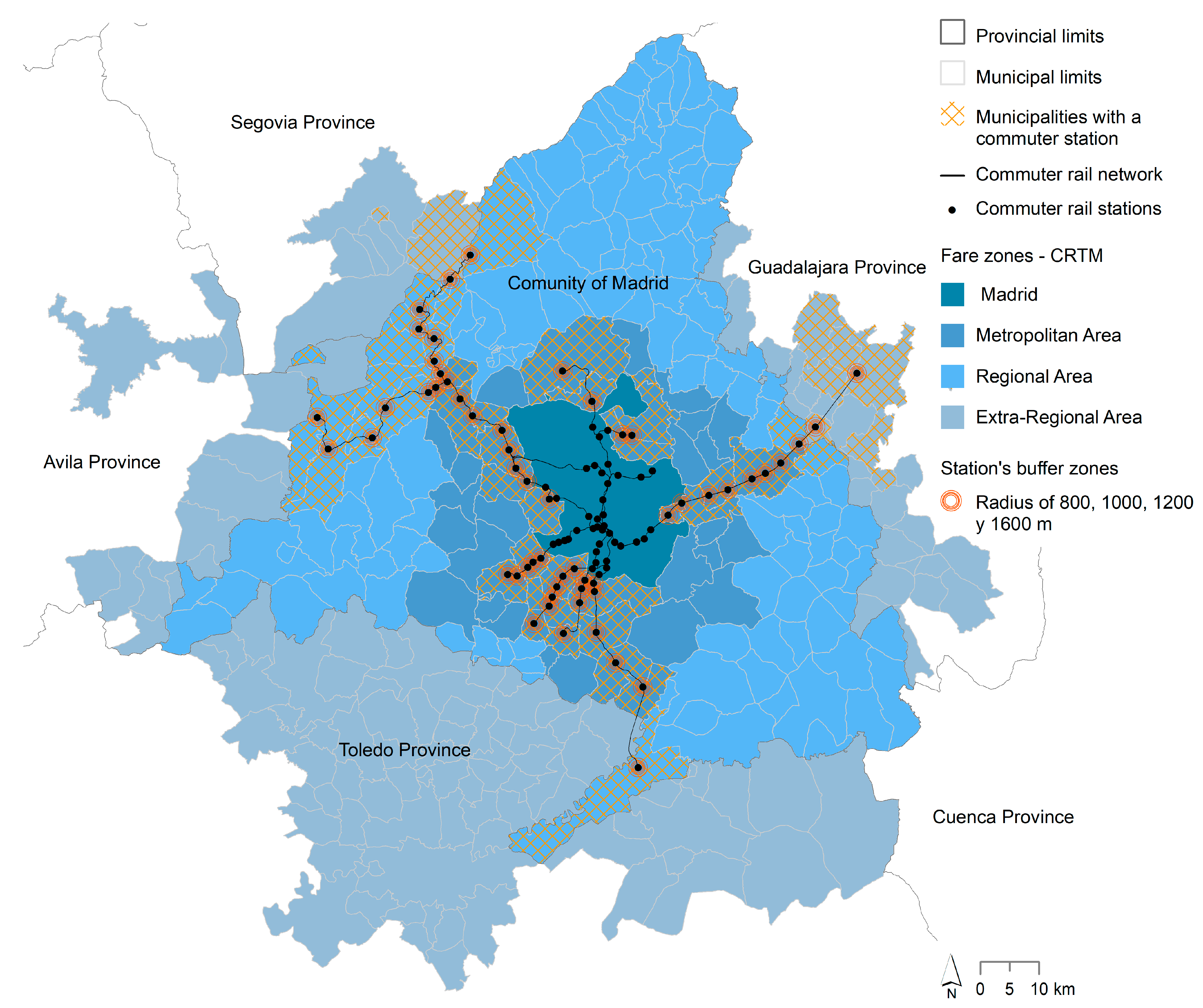
2.1. Case Study: The Madrid Urban Region

This research studies the Madrid urban region within the limits currently established by the Madrid Regional Transport Consortium, Consorcio Regional de Transportes de Madrid (CRTM), as shown in Figure 1. This exceeds the boundaries of the actual administrative region—i.e., the autonomous Community of Madrid—and extends through municipalities in the neighbouring regions of Castilla-La Mancha (Cuenca, Guadalajara, and Toledo provinces) and Castilla y León (Avila and Segovia provinces). Of the 15 Spanish urban regions that have a commuter rail service, Madrid has the largest network regarding commercial lines (9 lines, 2 of them fork into 2 other sub-lines), network length (391 km of tracks), number of stations (94 in total, 59 outside of the municipality of Madrid), daily services (1385 services) and passengers (almost 900,000) [36,37]. There are 35 municipalities that have a commuter railway station, although this figure increases to 45 when considering a catchment area radius of 1600 m around the station.

2.2. Research Methods

To address the first research objective—i.e., to investigate and describe the land occupation and mobility patterns in the Madrid urban region—three core factors are taken into consideration from a diachronic perspective (1990–2018): land use, the amount of artificial surface; basic sociodemographic data, the number of inhabitants and jobs; and some basic travel data, including the number of trips, transportation mode (private vehicle, public transport, others) and the origins and destinations (Madrid city, metropolitan belt, regional belt, or outside the autonomous community). These three factors have been used to characterise the sociospatial transformations in previous studies; this study, however, considers the three of them simultaneously and investigates their evolution for different time intervals, depending on the available data.
To investigate the evolution of the artificial land surface, data from the Evolution of Land Use in the Community of Madrid (1956–2005)—Evolución de la Ocupación del Suelo en la Comunidad de Madrid (1956–2005) [38]—and CORINE Land Cover [39] in 1990 and 2018 were used. Artificial surface is a direct indicator of urban expansion. For this work, artificial surfaces are grouped using three of the four categories that CORINE Land Cover identifies as artificial surfaces: urban fabric (areas mainly occupied by dwellings and buildings used by administrative/public utilities, including their connected areas); industrial, commercial and transport units (areas mainly occupied by industrial activities of manufacturing, trade, financial activities and services, transport infrastructures for road traffic and rail networks, airport installations, river and sea port installations, including their associated lands and access infrastructures); and artificial non-agricultural vegetated areas (areas voluntarily created for recreational use, including green or recreational and leisure urban parks, sport and leisure facilities). The fourth category—mines, dump sites and construction sites—was not considered.
Population data were obtained from the National Institute of Statistics, Instituto Nacional de Estadística, through the Population Census, Censo de Población, and the Continuous Population Register, Padrón Contínuo [40]. Data on the employed population were obtained from the 1991 Population Census; for 2018, the data were obtained from Social Security, Seguridad Social, affiliates provided by the Ministry of Inclusion, Social Security and Migration [41].
Mobility data was acquired from the Household Mobility Surveys, Encuestas Domiciliarias de Movilidad and prepared by the Planning and Coordination Commission of the Metropolitan Area of Madrid, Comisión de Planeamiento y Coordinación del Área Metropolitana de Madrid (COPLACO) in 1974 and 1981 [42] and the information prepared by CRTM in 1996, 2004, 2012 and 2018 [43]. (COPLACO was an autonomous body, of an urban nature, of the State Administration. It was created by law in 1963 to “promote, agree, guide, coordinate and supervise urban planning” within an area that included twenty-three municipalities located around Madrid, including that of this city. In 1983, within the process of building the State of the Autonomies, the functions of COPLACO were transferred to the Autonomous Community of Madrid) The data obtained from the Household Mobility Surveys in 1974 and 1981 consider the metropolitan area defined by COPLACO at that time, while the data subsequently obtained pertain to the urban region delimited by CRTM and were divided into fare zones.
To approach our second objective, we concentrated on the situation in 1991 and 2018 and examined the changes in this period in terms of population, employment, and artificial land, differentiating and comparing municipalities with and without stations. We characterized the municipalities of the Madrid urban region based on their population and employment densities and compared those with and without stations. We also classified the former based on the number of commuter rail trips (in and out) per population—using data from 2018, which were the most recent available—and investigated possible relations between the use of the commuter rail and the population and employment densities.
Lastly, to study the potential for urban growth around railway stations, we first analysed the evolution of artificial area from 1990 to 2018 using CORINE Land Cover data. Then, we analysed with greater detail the current amounts of each type of land from an urban development perspective. To do so, we distinguished following classifications according to the current legislation in Spain. Based on this, the land of a given municipality can be: (a) consolidated urban; (b) non-consolidated urban; (c) sectorized developable; (d) non-sectorized developable; and (e) non-developable land. The last item includes land that is protected and should not be developed for various reasons, e.g., environmental reasons or flooding risk, as well as land the current legal status of which does not allow the city to grow over it but could be developed in the future.
Analysis of the areas around the stations based on classifications according to current municipal urban planning provides a more refined estimate of how much land is likely to be built, on land already parcelled out, or undergo a new process of plot delimitation, urbanization and building around the stations. Based on this analysis of the types of land, we classified the stations and mapped the potential urban growth in the short, medium and long term around the stations. The short and medium terms were assimilated with the category of developable land, while the long term was assimilated with potentially developable land, i.e., the category of non-developable land, excluding from it what was protected.
We analysed the areas within 800, 1000, 1200 and 1600 m around each station, corresponding to walking trips of 10 to 20 min. The limits of the catchment area around a commuter rail station are not clear and vary across cultures and geographies. We set the limit as 1600 m (1 mile), as this is one of the maxima considered in previous studies [1,44,45,46] and considering that the travel times for this first or last mile could be much shorter for people using a bicycle, a personal mobility vehicle or other modes of public transportation to travel to/from the station.

3. Results and Discussion

3.1. Urban Expansion and Mobility Patterns in the Madrid Urban Region

In the last six decades, the Madrid urban region has increased its population by 5.5 million; this demographic growth has established it as one of the densest regions in Spain and Europe, reaching 508 inhabitants per km2 in 2018. During this period, the artificial surface grew by 1360.1 km2. However, the way in which the territory is occupied has changed from denser and more compact forms to less dense and more dispersed forms, thus increasing the urban footprint per inhabitant. In this sense, the proportion of urban land area per inhabitant increased from 65 m2 per capita in 1956 to 203 m2 per capita in 2018 (Table 2).
In parallel to this process of land occupation, increasingly fewer sustainable travel patterns are unfolding. According to the data provided by the Mobility Surveys by COPLACO in 1974 and by CRTM in 2018, mobility by private vehicle has increased from 23.0% to 39.0%, while travel on foot has decreased from 47.2% to 34.0%, and travel by public transport has decreased from 29.9% to 24.3%. Table 3 shows that, from 1988 to 2018, travel by public transport decreased considerably, while motorized mobility by private transport increased, increasing levels of congestion, especially after the economic crisis [47]. If we consider the evolution using the base index = 100, the relative indicator for the number of trips per day is considerably higher than that for jobs and population, which highlights the spatial mismatch in the location of jobs and the location of the population. This mismatch is the result of several factors; among them, notably, is that the labour market and the housing market obey different logics, and the current urban framework covers a city production process based on the low density and compactness and the high specialization of the built spaces. A reality that is also palpable is the increase in the number of vehicles per capita, increasing from 0.39 in 1988 to 0.74 in 2018, and the number of trips per day and per capita, increasing from 1.29 in 1988 to 1.61 in 2018.
Although it has not been possible to obtain disaggregated data at the municipal level, the Household Mobility Surveys provide information on the evolution of trips by mode of transport between areas (Figure 1 and Table 4). In the city of Madrid, the trend shows an increase in active mobility (on foot and by bike), a slight reduction in the use of public transport and a significant decrease in the use of private transport. Regarding the relations between Madrid and its metropolitan and regional belts, there is a decrease in trips by public transport and an increase in trips by private vehicle. This reality collides with the positive attributes of the radial character of the commuter train; it is a mode of transport that facilitates mass mobility between the periphery and the centre, and vice versa. One of the reasons why the use of this mode of transport has decreased is linked to the lack of investment and thus the lack of trains and services. This situation leaves the commuter train in a less competitive and attractive position compared to the private vehicle. Another reason is a lack of integration between urban planning (municipal administration) and regional transport planning (regional and national administrations), unable to promote the integration of the most sustainable transportation modes in the city or the area closest to the station [48]. Regarding the relationships that occur between the metropolitan belt and the regional belt, it is worth noting the increase in trips by public transport but the even greater rise in trips by private motorized vehicle. Thus, despite improvements such as the creation of parking lots in commuter stations or the implementation of intercity tangential bus services, private transport still is the most used mode of transport, with the greatest expansion in recent decades [32,48].
In short, the Madrid territorial model has moved from a monocentric-type structure based on compact and dense growth towards a more complex structure in which dispersion and polycentrism are intermingled in spatial areas increasingly distant from the centre and without meeting sustainable design criteria in the urban spaces that are produced. Consequently, this urban warp entails a progressive peripheralization and thus a more multidirectional nature of flows.

3.2. Characterization of the Municipalities with and without Commuter Stations

In the Madrid urban region, there are 250 municipalities with no commuter station and 45 (excluding Madrid) with at least one. As seen in Table 5, although Madrid has lost its majority share in relation to the population, it maintains its share in terms of employment, and it still is the main node of the regional urban system. The evolution and current proportion with respect to the population, employment and artificial land area show a commitment to an occupation model that does not seek to take advantage of the existence of the commuter network to promote greater growth in the municipalities with commuter stations. Thus, of the total demographic growth experienced in the Madrid urban region between 1991 and 2018, municipalities with a commuter station accounted for 804,400 people (47.4%), and municipalities without stations accounted for 916,700 (41.6%), while the population of Madrid city itself increased by 212,800 (representing only 11.0% of the total demographic growth of the urban region).
Regarding the increase in employment for the same period, the municipalities with a commuter station accounted for 22.4% of the regional total, and those without stations accounted for 19.3%, while the city share was as large as 58.3%—even greater than all the other municipalities combined.
The evolution of the population density and employment indices confirms that the urban and metropolitan space produced in recent decades is less dense. Considering the ratio between the commuter trips and the inhabitants in each municipality, Figure 2 shows a map of the degree of density for municipalities with and without a commuter station. This map illustrates that as we move away from Madrid city, densities go down. The only exceptions are the provincial capitals (Ávila, Guadalajara, Segovia, and Toledo) and sometimes one of their neighbouring municipalities, and the eastern and southern axes towards Guadalajara and Toledo, respectively.
In the municipalities without stations, very low densities prevail (200 out of 250, which account for 80% of them), while not even 1% reach a medium-high density (just 2 out of 250). On the other hand, among the municipalities with commuter stations, medium-low and medium-high densities dominate (67%), while there are also very low densities in 28% of them. They, however, are concentrated in the northwest, where the commuter rail was built with a more recreational purpose, to make the Guadarrama sierra, a National Park since 2013, accessible to Madrilenians.
Two clearly different spatial logics are clearly shown in the map. For the municipalities adjacent to Madrid, those in the south show higher densities (medium-high) than those in the north (medium-low to very low). Regarding the railway axes, municipalities in the south and east axes (medium-high and medium-low) are denser than the ones in the northwest axis (medium-low to very low).
Figure 2 indicates that urban density at the municipal scale does not mean higher ratios of commuter rail users. This is apparent in the northwest municipalities—which show great differences in commuters-to-population ratios and similar densities— but also in the other axes and the first belt around Madrid. Figure 3 confirms that there is no relation between these two factors.
This lack of relation between densities and levels of use may be due to several factors that we cannot test since relevant detailed data on services and use are not available. However, there are three we can suggest based on what the map shows. First, the analysis suggests that the production of the metropolitan urban space has been based on simultaneous growth with equal intensity in municipalities with and without commuter stations. It is a dynamic promoted by public and private agents who have developed the urban region and the commuter railway network with little or no coordination. Second, urban expansion has been carried out under dispersed forms of occupation, independent and not oriented to commuter stations. This has been supported by flows that progressively become peripheral, further away from the stations, and acquire a more multidirectional character, so that the radial commuter network has lost competitiveness to the road network. The development and configuration of the latter is the third factor that should be highlighted. In the last 3 decades, the road network in the Madrid urban area has been greatly developed. The historic radial configuration based on six roads that was conceived in the 18th century to connect the capital with the rest of the country (N-I to N-VI) was gradually adapted for the new means of transport, but in the last three decades, most have been not only widened and transformed into highways (A1 to A6), but also duplicated with new radial highways that run approximately parallel to the pre-existing ones (e.g., R2, R3, R4). On top of that, new concentric ring highways around Madrid have been built interconnecting the radial highways (M30, M40, M45, and M50).
One way to evolve towards a more sustainable urban development and mobility system could be to encourage the use of the existing commuter rail network and develop its full potential from a planning perspective. The following section explores urban development potential around the commuter stations and puts forward a classification based on their urban development capacity in the short, medium and long terms.

3.3. The Urban Development Potential of the Commuter Station Areas

The evolution of artificial surfaces between 1990 and 2018 shows that there is still a large amount of land that is not occupied around the stations (Table 6). In 2018, considering the total number of municipalities with a commuter station, there are almost 220 km2 of undeveloped land within a radius of 1600 m from the station. This area is greater than the urban growth experienced more than 1600 m away from the stations between 1990 and 2018 for all these municipalities, i.e., 176.4 km2. This suggests that urban expansion has not been informed by the location of the stations neither at the municipal nor the regional scales.
Table 7 shows that municipalities without a commuter station have a greater amount of non-consolidated urban land and developable land than municipalities with a commuter station. This suggests that, in a free market context and without an urban and metropolitan strategy that prioritises and shapes urban growth around the stations, there is a high probability that a diffuse occupation will prevail and be consolidated, making it more difficult to foster a more sustainable mobility.
Data show that there is room to grow and readjust the areas around the stations. There are 75.1 km2 of non-consolidated urban land and developable land within 1600 m of the stations. In addition, there are 49.8 km2 of potentially developable land (currently non-developable but not protected) that could be classified as urban land. In total, this accounts for 124.9 km2 1, which is 30% of the 415.8 km2 of the urban land built throughout history in those municipalities with a station.
Considering the developable and potentially developable land, Figure 4 shows a classification of station areas with different capacities for urban growth in the short, medium, and long terms: (i) Type I has low capacity for urban expansion (<50 ha of developable and <50 ha of potentially developable land); (ii) Type II has medium-low growth potential (50–100 ha of developable and 50–100 ha of potentially developable land); (iii) Type III has limited possibilities to develop in the short and medium terms (<100 ha of developable land) and greater options in the long term (>100 of potentially developable land); (iv) Type IV, just the opposite, has greater options in the long term (>100 of developable land) but limited possibilities in the short and medium terms (<100 ha of potentially developable land); and (v) Type V has great development potential now and in the future (>100 ha of developable land and >100 ha of potentially developable land).
This classification and the corresponding data show there is a lot of growth potential in the short and medium terms (predominance of Type IV) around many stations that are close to Madrid municipality along the south and east lines. If a coordinated urban and transportation strategy—both at the municipal and metropolitan scales—is established considering the existing urban land and the developable and potentially developable land in the areas around commuter railway stations, there is a lot of room for progress towards a more polycentric and more sustainable urban and regional development. In this sense, urban planning should ensure that new urban growth meets the density, compactness, and land use mix criteria. The urban areas around stations are the drivers of mobility. Therefore, the way in which the management and characteristics of land uses are established could make the commuter rail network more sustainable from environmental, social, and economic perspectives. This could facilitate an increase in investment in public transport, making it more competitive and convenient than other modes of transport that are less sustainable. More trains and more services, more buses and routes within the station areas, and a better-designed public space are needed.
It would be desirable that this combined strategy consider the whole urban region. However, other possibilities could be easier to coordinate and promote. Partial strategies by commuter rail lines would be very useful also—e.g., the contrats d’axe (axial agreements) implemented in France along the transit axis [49]. Municipalities with commuter stations along a common axis, by areas or for the whole urban region, could collaborate to promote, lead and coordinate new strategies and policies to maximize the development potential they represent, for example, promoting urban growth in station areas in the face of dispersion, launching mobility plans and designing public space in station areas, developing urban rehabilitation and regeneration policies to upgrade designs that are obsolete in physical terms and outdated in social terms or promoting commuter train stations as spaces for businesses, tourism, retail and education activities in the urban areas around the stations.

4. Conclusions

Improving the sustainability of current and future urban regions through unified—or, at least, coordinated—planning and transportation strategies is not new. It is the basis of the TOD concept. Although introduced in the 1990s, researchers still work on how to implement and apply the concept today in different situations around the world [50,51,52,53]. This study proposes that the interaction between a railway station and its surrounding urban area, when understood with network logic and as a system of nodes and places, can serve as a tool to reorient the processes of metropolitan diffusion, structuring a new multicentre system that supports a renewed economic and social vitality and articulates a more sustainable mobility model. To make this tool operational, three categories of analysis are distinguished: municipalities with a commuter station, municipalities without a commuter station, and urban station areas. The analysis of different dynamics (demographic, economic, mobility, etc.) through these categories allows an assessment of the extent of the potential benefits derived from the presence of a train station, the proximity to the station and the accessibility that the train provides to other urban and metropolitan spaces.
Based on this interpretation, the Madrid urban region has a powerful commuter rail infrastructure that is currently not used to its full potential and could further contribute to the sustainable development of the region. Now, there is no strategy or policy that identifies the importance of linking urban growth and development with the construction of a regional network of places (commuter stations and their surrounding areas) oriented to public transport (commuter network). This study could guide more-detailed and in-depth studies that, considering other factors and data not available to this research team, could guide not only the development of the areas around the station—investigated in this work—but also the location of future stations and the extension of the rail network based on the actual residential and employment densities as well as those planned by the municipalities. While this paper is being reviewed, a new station is being announced to be built by the Ministry of Transport, Mobility and Urban Agenda in one of the municipalities in the South (Parla) without considering a possible future urban development of the area but the construction of parking and “kiss and ride” areas [54,55].
There is a need to promote studies that analyse and provide ideas and proposals on how to take advantage of the growth and development potential not only of the areas surrounding commuter train stations on an urban and metropolitan scale, but also of conventional trains in urban areas and rural areas to respond to different current and near-future challenges such as depopulation, sustainable mobility, diffuse urbanization, and urban regeneration.

Author Contributions

Conceptualization, E.S., B.R.-A., A.M., I.M. and J.M.C.; Methodology, E.S., A.M. and I.M.; Investigation, E.S., B.R.-A., A.M., I.M. and J.M.C.; Writing—original draft, E.S.; Writing—review & editing, E.S and B.R.-A.; Project administration, J.M.C.; Funding acquisition, J.M.C. All authors have contributed to the conception and development of the research, led by E.S. and J.M.C. All authors have read and agreed to the published version of the manuscript.

Funding

This research was funded by the MINISTERIO DE CIENCIA E INNOVACIÓN. Proyecto de I+D+I PID2020-119360RB-100, Railway stations in the mobility of the metropolitan periphery. Towards rail stations 4.0: intelligent and integrated (M = EI2).

Institutional Review Board Statement

Not applicable.

Informed Consent Statement

Not applicable.

Conflicts of Interest

The authors declare no conflict of interest. The funders had no role in the design of the study; in the collection, analyses, or interpretation of data; in the writing of the manuscript; or in the decision to publish the results.

References

  1. Calthorpe, P. The Next American Metropolis: Ecology, Community, and the American Dream; Princeton Architectural Press: New York, NY, USA, 1993; ISBN 1878271687. [Google Scholar]
  2. Bertolini, L. Nodes and Places: Complexities of Railway Station Redevelopment. Eur. Plan. Stud. 1996, 4, 331–345. [Google Scholar] [CrossRef]
  3. UN-Habitat. Planning and Design for Sustainable Urban Mobility: Global Report on Human Settlements 2013-Policy Directions; UN-Habitat: Nairobi, Kenya, 2013. [Google Scholar]
  4. Banister, D. The Sustainable Mobility Paradigm. Transp. Policy 2008, 15, 73–80. [Google Scholar] [CrossRef]
  5. Wenner, F.; Thierstein, A. High Speed Rail as Urban Generator? An Analysis of Land Use Change around European Stations. Eur. Plan. Stud. 2021, 30, 227–250. [Google Scholar] [CrossRef]
  6. Santos, L. Urbanismo y Ferrocarril: La Construcción Del Espacio Ferroviario En Las Ciudades Medias Españolas; Fundación de los Ferrocarriles Españoles: Madrid, Spain, 2011; ISBN 978-84-89649-02-6. [Google Scholar]
  7. Delgado Viñas, C.; Lagüera Díaz, S. Morfología Urbana, Infraestructuras Ferroviarias y Crecimiento Económico En Las Ciudades Cántabras. Investig. Geogr. 2020, 74, 85–112. [Google Scholar] [CrossRef]
  8. Bellet, C.; Alonso, P.; Gutiérrez, A. The High-Speed Rail in Spanish Cities: Urban Integration and Local Strategies for Socio-Economic Development. In Territorial Implications of High Speed Rail: A Spanish Perspective; Ureña, J.M., Ed.; Ashgate: London, UK, 2012; pp. 163–196. [Google Scholar]
  9. De Ureña, J.M. (Ed.) Territorial Implications of High Speed Rail: A Spanish Perspective; Routledge: Oxford, UK, 2012; ISBN 9781315612065. [Google Scholar]
  10. Cardozo, O.D.; Gutiérrez, J.; García, J.C. Influencia de La Morfología Urbana En La Demanda de Transporte Público: Análisis Mediante SIG y Modelos de Regresión Múltiple. GeoFocus Int. Rev. Geogr. Inf. Sci. Technol. 2010, 10, 82–102. [Google Scholar]
  11. Valenzuela Montes, L.M.; Soria Lara, J.A.; Talavera Garcia, R. Towards Integration of Planning and Metropolitan Mobility Projects in Andalusia, Spain. Scr. Nova-Rev. Electrón. Geogr. Cienc. Soc. 2011, 15, 349. [Google Scholar]
  12. Bellet, C.; Gutiérrez, A. Ciudad y Ferrocarril En La España Del Siglo XXI. La Integración de La Alta Velocidad Ferroviaria En El Medio Urbano. Bol. Asoc. Geógr. Esp. 2011, 55, 251–279. [Google Scholar]
  13. Ortuño Padilla, A. El Modelo “Transit Oriented Development (T.O.D.)”: Posibilidades de Implementación En El Corredor Alicante-Benidorm. riURB 2013, 10, 23–33. [Google Scholar]
  14. Adelfio, M.; Hamiduddin, I. Transit-Oriented Mixed Communities: Social Sustainability Lessons from Case Studies of Germany and Spain. In Proceedings of the Irish Transport Research Network 2014, Limerick, Ireland, 3–5 September 2014. [Google Scholar]
  15. Fernández-Morote, G.; Ortuño Padilla, A.; Fernández-Aracil, P.; Melgarejo-López, A. Implantación Del Modelo Transit-Oriented Development (TOD) En San Vicente Del Raspeig-Universidad de Alicante. In Proceedings of the XI Congreso de Ingeniería del Transporte (CIT), Santander, Spain, 9–11 June 2014. [Google Scholar]
  16. Soria-Lara, J.A.; Valenzuela Montes, L.M. Más Allá de La Estructura Urbana y El Patrón de Viaje. El “Entorno de Movilidad” Como Instrumento Para La Planificación y Evaluación. Bol. Asoc. Geógr. Esp. 2014, 64. [Google Scholar] [CrossRef] [Green Version]
  17. Bellet, C.; Santos, L. The High-Speed Rail Project as an Urban Redevelopment Tool. The cases of Zaragoza and Valladolid. Belgeo Rev. Belg. Géogr. 2016, 3. [Google Scholar] [CrossRef] [Green Version]
  18. Fernández Herráiz, H.; Sánchez Galiano, J.C.; Fernández Aracil, P.; Ortuño Padilla, A. Implementación Del Modelo Transit-Oriented Develpment (TOD) En La Ciudad de Alicante. In Proceedings of the XII Congreso de Ingeniería del Transporte, Valencia, Spain, 7–9 June 2016. [Google Scholar] [CrossRef] [Green Version]
  19. Lamíquiz, P.; Pozueta, J.; Benito, M.; González, J. Desarrollos Urbanos y Transporte Público Ferroviario. El Caso En La Región Metropolitana de Madrid: TODs, TADs y TJDs. Pap. Regió Metrop. Barc. 2017, 59, 58–76. [Google Scholar]
  20. García-Palomares, J.C.; Sousa Ribeiro, J.; Gutiérrez, J.; Sá Marques, T. Analysing Proximity to Public Transport: The Role of Street Network Design. Bol. Asoc. Geógr. Esp. 2018, 18, 102–130. [Google Scholar] [CrossRef] [Green Version]
  21. Moyano, A.; Coronado, J.M.; Ruiz, R.; Romero, V. Station Avenue: High-Speed Rail’s Missing Link. Assessing Pedestrian City-Station Routes for Edge Stations in Spanish Small Cities. J. Hous. Built Environ. 2018, 34, 175–193. [Google Scholar] [CrossRef]
  22. Valenzuela Rubio, M. Los Procesos de Metropolización. Madrid, Una Región Metropolitana Entre La Dispersión y El Policentrismo. In España en lUnión Europea. Un Cuarto de Siglo de Mutaciones Territoriales; Humbert, A., Molinero, F., Valenzuela, M., Eds.; Collection de la Casa de Velázquez: Madrid, Spain, 2011; pp. 211–253. [Google Scholar]
  23. Córdoba Hernández, R.; Morcillo Álvarez, D. Marco Territorial de La Producción de Espacio En La Región Funcional de Madrid. Ciudades 2020, 23, 71–93. [Google Scholar] [CrossRef]
  24. Equipo de Barcelona. Más Viajeros, Más Trenes, Menos Emisiones. Bases Para Doblar El Número de Viajeros Por Ferrocarril En España. 2021. Available online: https://transportpublic.org/wp-content/uploads/2021/07/210719_doc-estrategico-FFCC-Espana.pdf (accessed on 20 February 2023).
  25. Martínez Palencia, L.M.; Martín Duque, D.; Gómez López, F.J.; González García, D. Plan Estratégico de Movilidad Sostenible de La Comunidad de Madrid 2013–2025. In Proceedings of the XII Congreso de Ingeniería del Transporte, Valencia, Spain, 7 June 2016; pp. 2065–2084. [Google Scholar]
  26. Sánchez Gutiérrez, J.I. Planificación Integrada Frente al Insostenible Modelo de Movilidad al Trabajo En La Comunidad de Madrid. Rev. Econ. 2012, 12, 95–124. [Google Scholar] [CrossRef] [Green Version]
  27. Muñoz Miguel, J.P.; Simón de Blas, C.; Jiménez Barandalla, I.C. Estudio Empírico Sobre La Utilización Del Transporte Público En La Comunidad de Madrid Como Factor Clave de Movilidad Sostenible. Cuad. Econ. 2014, 37, 112–124. [Google Scholar] [CrossRef] [Green Version]
  28. Instituto para la Diversificación y Ahorro de la Energía. PMUS: Guía Práctica Para La Elaboración e Implantación de Planes de Movilidad Urbana Sostenible; Ministerio de Industria, Energía y Comercio: Madrid, Spain, 2006; ISBN 9788486850982.
  29. Autoridad Independiente de Responsabilidad Fiscal La AIReF Constata El Fuerte Esfuerzo Inversor En La Alta Velocidad Frente a Una Inversión Insuficiente En Cercanías y Propone Poner El Foco En Los Criterios de Movilidad 2020. Available online: https://www.airef.es/es/noticias/la-airef-constata-el-fuerte-esfuerzo-inversor-en-la-alta-velocidad-frente-a-una-inversion-insuficiente-en-cercanias-y-propone-poner-el-foco-en-los-criterios-de-movilidad/ (accessed on 19 February 2023).
  30. RENFE. 2019 Informe de Responsabilidad Social y Gobierno Corporativo; RENFE: Madrid, Spain, 2020; Available online: https://www.renfe.com/content/dam/renfe/es/Grupo-Empresa/Gobierno-corporativo-y-transparencia/informes-rse/2019%20Informe%20de%20Responsabilidad%20Social%20y%20Gobierno%20Corporativo.pdf (accessed on 19 February 2023).
  31. Ministerio De Transportes, Movilidad Y Agenda Urbana. Observatorio Del Transporte y La Logística En España. Available online: https://apps.fomento.gob.es/bdotle/visorBDpop.aspx?i=427 (accessed on 20 February 2023).
  32. Monzón de Cáceres, A.; de la Hoz Sánchez, D. Efectos Sobre La Movilidad Dinámica Territorial de Madrid. Urban 2009, 14, 58–71. [Google Scholar]
  33. Moreno, C.; Allam, Z.; Chabaud, D.; Gall, C.; Pratlong, F. Introducing the “15-Minute City”: Sustainability, Resilience and Place Identity in Future Post-Pandemic Cities. Smart Cities 2021, 4, 93–111. [Google Scholar] [CrossRef]
  34. Pozoukidou, G.; Chatziyiannaki, Z. 15-minute City: Decomposing the New Urban Planning Eutopia. Sustainability 2021, 13, 928. [Google Scholar] [CrossRef]
  35. Borghetti, F.; Colombo, C.G.; Longo, M.; Mazzoncini, R.; Cesarini, L.; Contestabile, L.; Somaschini, C. 15-Min Station: A Case Study in North Italy City to Evaluate the Livability of an Area. Sustainability 2021, 13, 10246. [Google Scholar] [CrossRef]
  36. Fundación de los Ferrocarriles Españoles. Observatorio Del Ferrocarril En España. Informe 2020; Fundación de los Ferrocarriles Españoles: Madrid, Spain, 2021; Available online: https://cdn.mitma.gob.es/portal-web-drupal/ferroviario/observatorio/ofe_2020.pdf (accessed on 19 February 2023).
  37. RENFE; ADIF. Plan Integral de Mejora de Los Servicios de Cercanías de Madrid. Inversiones Para El Periodo de 2018 a 2025; RENFE: Madrid, Spain; ADIF: Madrid, Spain, 2018. [Google Scholar]
  38. Comunidad de Madrid Evolución de La Ocupación Del Suelo En La Comunidad de Madrid (1956–2005). 2005. Available online: https://www.comunidad.madrid/sites/default/files/aud/urbanismo/cma_urb_evolucion_1956_2005_ocupacion_suelo_cm.pdf (accessed on 19 February 2023).
  39. European Union. Copernicus Land Monitoring Service CORINE Land Cover; European Union: Maastricht, The Netherlands, 2021; Available online: https://land.copernicus.eu/pan-european/corine-land-cover (accessed on 19 February 2023).
  40. Instituto Nacional de Estadística INEbase/Demografía y Población. Available online: https://www.ine.es/dyngs/INEbase/es/categoria.htm?c=Estadistica_P&cid=1254734710984 (accessed on 19 February 2023).
  41. Ministerio de Inclusión, Seguridad Social y Migraciones. Seguridad Social: Estadísticas. Available online: https://www.seg-social.es/wps/portal/wss/internet/EstadisticasPresupuestosEstudios/Estadisticas/est8/est167/5b11b695-cf1c-4abe-8a12-ecd2d0d15271/2683 (accessed on 19 February 2023).
  42. Valero Lobo, Á. Movilidad Espacial En Madrid. An. Geogr. Univ. Complut. 1984, 4, 207–225. [Google Scholar]
  43. Consorcio Regional del Transporte de Madrid Encuesta Domiciliaria de Movilidad|Comunidad de Madrid. Available online: https://www.comunidad.madrid/servicios/transporte/encuesta-domiciliaria-movilidad (accessed on 19 February 2023).
  44. Martínez, H.S.; Moyano, A.; Coronado, J.M.; Garmendia, M. Catchment Areas of High-Speed Rail Stations: A Model Based on Spatial Analysis Using Ridership Surveys. Eur. J. Transp. Infrastruct. Res. 2016, 16, 364–384. [Google Scholar] [CrossRef]
  45. Olaru, D.; Moncrieff, S.; McCarney, G.; Sun, Y.; Reed, T.; Pattison, C.; Smith, B.; Biermann, S. Place vs. Node Transit: Planning Policies Revisited. Sustainability 2019, 11, 477. [Google Scholar] [CrossRef] [Green Version]
  46. Yang, R.; Yan, H.; Xiong, W.; Liu, T. The Study of Pedestrian Accessibility to Rail Transit Stations Based on KLP Model. Procedia Soc. Behav. Sci. 2013, 96, 714–722. [Google Scholar] [CrossRef] [Green Version]
  47. Moyano, A.; Stępniak, M.; Moya-Gómez, B.; García-Palomares, J.C. Traffic Congestion and Economic Context: Changes of Spatiotemporal Patterns of Traffic Travel Times during Crisis and Post-Crisis Periods. Transportation 2021, 48, 3301–3324. [Google Scholar] [CrossRef]
  48. Solís, E.; Ruiz-Apilánez, B.; Sánchez, V. Los Planes de Movilidad Urbana Sostenible y Su Incidencia En La Forma y Movilidad En Los Entornos de Las Estaciones de Ferrocarril de Cercanías Metropolitano Madrileño: El Caso de Getafe, Móstoles, Leganés y Alcorcón. In Proceedings of the V Congreso ISUF-H Ciudades Espontáneas vs. Ciudades Planificadas: Distintos retos, Distintas Realidades, Universidad de Costa Rica, San José, Costa Rica, 1–3 December 2021. [Google Scholar]
  49. Maulat, J.; Krauss, A. Using Contrats d’axe to Coordinate Regional Rail Transport, Stations and Urban Development: From Concept to Practice. Town Plan. Rev. 2014, 85, 287. [Google Scholar] [CrossRef]
  50. Hasibuan, H.S.; Mulyani, M. Transit-Oriented Development: Towards Achieving Sustainable Transport and Urban Development in Jakarta Metropolitan, Indonesia. Sustainability 2022, 14, 5244. [Google Scholar] [CrossRef]
  51. Newman, P.; Davies-Slate, S.; Conley, D.; Hargroves, K.; Mouritz, M.; de Paola, P. From TOD to TAC: Why and How Transport and Urban Policy Needs to Shift to Regenerating Main Road Corridors with New Transit Systems. Urban Sci. 2021, 5, 52. [Google Scholar] [CrossRef]
  52. Motieyan, H.; Mesgari, M.S. Towards Sustainable Urban Planning Through Transit-Oriented Development (A Case Study: Tehran). ISPRS Int. J. Geo-Inf. 2017, 6, 402. [Google Scholar] [CrossRef] [Green Version]
  53. Guo, Y.; Zhou, Y.; Li, W.; Liu, J.; Almatar, K.M. Transit-Oriented Development in Saudi Arabia: Riyadh as a Case Study. Sustainability 2022, 14, 16129. [Google Scholar] [CrossRef]
  54. Ministerio De Transportes, Movilidad Y Agenda Urbana. Mitma Confirma su Compromiso con una Movilidad Sostenible con el Impulso a la Nueva Estación de Cercanías de Parla Norte. 2023. Available online: https://www.mitma.gob.es/el-ministerio/sala-de-prensa/noticias/mie-25012023-1146 (accessed on 19 February 2023).
  55. Ayuntamiento de Parla Presentado El Proyecto de La Futura Estación de Cercanías de Parla Norte. 2023. Available online: https://www.ayuntamientoparla.es/noticias/presentado-el-proyecto-de-la-futura-estacion-de-cercanias-de-parla-norte (accessed on 19 February 2023).
Figure 1. The Madrid urban region and the commuter railway network.
Applsci 13 03953 g001
Figure 2. Typology of municipalities by population and employment densities and by the rail commuters-to-population ratio in 2018.
Applsci 13 03953 g002
Figure 3. Types of municipalities by density and passengers (in and out) per population in 2018.
Applsci 13 03953 g003
Figure 4. Types of station areas based on their capacity for urban expansion in the short, medium, and long terms.
Applsci 13 03953 g004
Table 1. Latest studies on TOD and the NPM in Spain since 2010.
Authors (Year)Transport ModeStudy LocationIndicators and Factors
Cardozo et al. (2010) [10]Subway and busMadridTotal number of passengers, number of subway lines, number of (inter)urban bus lines, net population, and employment density, mix of uses, and road density; 800 m radius
Valenzuela et al. (2011) [11]Light railGranada, Málaga and SevilleEvaluation of plans and projects for light rail development relating to innovations in the environmental, urban, management and quality, economic, technological, social, and modal fields
Bellet and Gutiérrez (2011) [12]High-speed railVarious Spanish citiesPosition of the station in the city and transformations in the urban structure
Ortuño (2013) [13]N/AAlicante–Benidorm AxisPopulation, population density, economic situation, competence framework, role of actors involved, and existing urban legislation; 800 m radius
Adelfio and Hamiduddin (2014) [14]Commuter railPolvoranca (Madrid) and Freiburg (Germany)Extension, number of dwellings, density, mix of land uses, average size of dwelling, population between 6 and 18 years of age, population over 65 years of age, average number of residents, percentage of population employed, bus service, train trips (percentage of residents) and percentage of residents who travel by car and public transport; 500 m radius
Fernández et al. (2014) [15]N/ASan Vicente del Raspeig-University of AlicanteLand use, accessibility of train and tram stops and opportunities; 800 m radius
Soria and Valenzuela (2014) [16]Light railGranadaResidential density, diversity of activities (urban activities per 1000 dwellings; percentage of different urban activities), temporal coverage of activities (percentage of urban activities by time slot), levels of motorized traffic (vehicles per urban activities and buses per urban activities), influence of transversal axes; 250 m radius
Bellet and Santos (2016) [17]High-speed railZaragoza and ValladolidStrategic metropolitan and urban plans: proposals for urban management (land use)
Fernández-Morote et al. (2016) [18]TramAlicanteAd hoc study of mobility, customer service staff, existence of taxi stops, number of (inter)urban bus destinations, bicycle parking capacity, daily (inter)urban bus frequency, vehicle parking capacity, rail accessibility, destinations reachable by the TRAM, daily frequency of TRAM use, number of workers by economic sector, resident population, and degree of functional mix; less than 1000 m radius
Lamíquiz et al. (2017) [19]Metro and commuter railMunicipalities of the Madrid regionLand occupation, gross area, net area, number of dwellings, density, and percentage of officially protected dwellings, area of uses, type of promotion and financing of the analyzed pieces, morphology, and pedestrian network; 600 and 800 m radii
García-Palomares et al. (2018) [20]SubwayMadridStreet network, synthetic indicator of accessibility (incorporates the number of people and jobs); 400 and 800 m radii
Moyano et al. (2019) [21] High-speed railAlbacete, Ciudad Real and ToledoStreet network (network readability, detours, orientation, section, presence of vegetation, street crossings, etc.)
Table 2. Evolution of the population and artificial surface of the Madrid urban region in selected years. Source: National Center for Geographic Information and National Institute of Statistics of Spain.
1956 119902000200620122018
Population1,823,4105,367,573 25,682,6176,606,6737,222,1157,301,569
Base index 100 = Year 1990 100106123135136
Artificial surface or urban land surface (km2)118.5704.61036.01312.21482.11478.6
Base index 100 = Year 1990 100147186210210
Density in the Madrid urban region (inhabitants per km2) 3227373395459502508
Proportion of area per inhabitant (m2 per capita)65131182199205203
Base index 100 = Year 1990 100139151156154
1: Evolución de la Ocupación del Suelo en la Comunidad de Madrid (Evolution of Land Use in the Community of Madrid) (1956–2005), prepared by the General Directorate of Urbanism and Territorial Strategy, Department of the Environment, Housing and Land Management of the Community of Madrid. 2: 1991 Census. There are no population data as of 1990. Starting in 1996, there are census data for every year. 3: The area of the Madrid urban region is 14,380 km2.
Table 3. Evolution of trips by public transport and private transport in the Community of Madrid. Source: Mobility Survey of 1988, 1996, 2004, 2014 and 2018 and Statistical Yearbook of the Community of Madrid. 1985–2020 Transport and communications.
YearTrips in Public Transport Trips in Private TransportTrips per Day1988 = 100 (Trip/Day) Population1988 = 100 (Inhabitants) Trips per Day and per CapitaVehicles per CapitaJobs1988 = 100 (Jobs)
19882578 (53.2%)2270 (46.8%)4848 (100%)100%3,758,000100%1.290.391,420,400100%
19963311 (52.8%)2954 (47.2%)6266 (100%)129%4,783,000127%1.310.551,683,100118.4%
20044932 (49.3%)5068 (50.7%)10,000 (100%)206%5,714,000152%1.750.642,669,500187.9%
20144837 (48.3%)5180 (51.7%)10,017 (100%)207%6,495,000172%1.540.662,776,600195.4%
20182496 (40.0%)6240 (60.0%)10,400 (100%)213%6,507,000173%1.610.742,841,800200.1%
Table 4. Evolution of daily trips (thousands) within and between the Madrid municipality, its metropolitan belt, its regional belt, and outside the Community of Madrid (i.e., beyond the boundaries of the province and autonomous community) in 1996, 2004 and 2018. Source: EDM (1996, 2004, and 2018).
Public TransportPrivate Motor VehicleOther
1996 12004 22018 3199620042018199620042018
Madrid city (municipality)2216.82927.72414.91171.81712.61690.6137.2215.7230.2
Madrid metropolitan belt302.5547.6493.5874.11676.12445.092.9114.192.1
Madrid regional belt11.316.323.4105.0229.5326.716.331.424.4
Madrid city-metropolitan belt721.5944.3791.9683.61016.71232.954.981.755.3
Madrid city-regional belt36.891.669.435.983.2111.03.23.13.7
Metropolitan belt-regional belt17.140.742.469.8163.1267.78.713.013.8
Outside the Community of Madrid6.613.615.237.771.4117.43.96.87.9
1: Of 4.9 million daily stages in public transport, commuter rail accounts for 10.9% (540,198). 2: Of 6.3 million daily stages in public transport, commuter rail accounts for 11.5% (733,396). 3: Of 5 million daily stages in public transport, commuter rail accounts for 13.0% (650,000).
Table 5. Evolution of the population, the working population and the artificial land area, distinguishing municipalities with and without a commuter station, between 1991 and 2018. Source: 1991 and 2018 Population Census (INE), Workers Affiliated to Social Security (Ministry of Inclusion, Social Security and Migrations) and CORINE Land Cover (National Geographic Information Centre).
YearUrban
Region
Madrid
Munipality
Municipalities
without Station
Municipalities
with Station
Percent 1 Percent 1 Percent 1
Population
(thousands of people)
19915367.63010.556.1%611.211.4%1745.932.5%
20187301.63223.344.2%1415.619.4%2662.636.4%
1991–2018+1934.0+212.8−11.9%+804.4+8.0%+916.7+4.0%
Working population
(thousands of people)
19912139.01224.257.2%228.810.7%685.932.1%
20183481.52007.057.7%487.914.0%986.628.3%
1991–2018+1342.5+782.8+0.5%+259.1+3.3%+300.7−4.2%
Artificial land surface
(km2)
1990704.6208.829.6%250.835.6%245.034.8%
20181478.6327.222.1%626.242.4%525.335.5%
1991–2018+774.0+118.4−7.5%+375.4+6.8%+280.3+0.7%
Population density
(thousands per km2)
19917621442-244-713-
2018494985-226-507-
Working population density
(thousands per km2)
1991304586-91-280-
2018236614-78-188-
1: Percentages correspond to the total amount in the Madrid urban region for the corresponding year. For the period 1991–2018, the variation in percentage is expressed.
Table 6. Artificial land (km2) in 1990 and 2018 around commuter railway stations in the Madrid urban region. Source: CORINE Land Cover—National Geographic Information Centre.
TotalArtificial Land in 1990 Artificial Land in 2018 Undeveloped Land in 2018
km2km2 km2 km2
800 m buffer 1112.651.846.0%82.373.1%30.326.9%
1000 m buffer 1175.973.341.7%119.067.6%57.032.4%
1200 m buffer 1253.394.537.3%158.362.5%95.037.5%
1600 m buffer 1450.3130.128.9%233.851.9%216.548.1%
Beyond the 1600 m buffer 22179.2115.05.3%291.413.4%1887.786.6%
Municipality total2629.5245.09.35525.320.0%2104.280.0%
1: Buffers around the stations also include the land of neighboring municipalities if within the corresponding area. 2: Buffers around the stations only include the land in the municipality where the station is.
Table 7. Amount of land types (km2) in the municipalities of the Madrid urban region and around the commuter rail stations. Source: Land classification of the Community of Madrid and Urban Information System—Ministry of Transport, Mobility and Urban Agenda.
Land typeMadrid Urban RegionMunicipalities with StationMunicipalities without StationMadrid Municipality800 m Buffer 11000 m Buffer 11200 m Buffer 11600 m Buffer 1Beyond 1600 m 4
Total 213,040.02481.29954.2604.6
Urban (consolidated) 31090.1415.8438.0236.369.199.9132.2193.8222.0
Urban (non-consolidated)136.431.155.549.85.97.610.015.215.9
Developable (sectorized)592.4171.5339.081.911.418.928.349.6121.8
Developable (non-sectorized)375.580.3281.913.21.12.44.110.370.0
Non-developable (currently)10,845.71782.68839.7223.4
Potentially developable 20.515.624.349.8506.9
Protected non-developable 5 17.129.746.795.51142.2
1: Around the stations, including land of neighboring municipalities without station inside the corresponding buffer. 2: The sum of the areas of the different land types does not add up the total area because for the municipalities with no general planning, no information is available. 3: Includes urban land and general systems. 4: Only includes land in the municipalities where the station is. 5: The Community of Madrid, through the Territorial Information System of the Community of Madrid (Classification and urban classification map of the Community of Madrid) updated as of 2019. See: https://datos.comunidad.madrid/catalogo/dataset/spacmvplaclasificacion2015, accessed on 15 May 2022.
Disclaimer/Publisher’s Note: The statements, opinions and data contained in all publications are solely those of the individual author(s) and contributor(s) and not of MDPI and/or the editor(s). MDPI and/or the editor(s) disclaim responsibility for any injury to people or property resulting from any ideas, methods, instructions or products referred to in the content.

