Article

Digitalization and Spatial Simulation in Urban Management: Land-Use Change Model for Industrial Heritage Conservation

by
Pablo González-Albornoz
1,2,*,
María Isabel López
3,
Paulina Carmona
3 and
Clemente Rubio-Manzano
4
1
Doctoral Program of Economics and Information Management, Department of Information Systems, University of the Bío-Bío, Concepcion 4030000, Chile
2
Faculty of Education, Universidad Adventista de Chile, Chillan 3780000, Chile
3
Department of Planning and Urban Design, University of the Bío-Bío, Concepcion 4030000, Chile
4
Department of Information Systems, University of the Bío-Bío, Concepcion 4030000, Chile
*
Author to whom correspondence should be addressed.
Appl. Sci. 2024, 14(16), 7221; https://doi.org/10.3390/app14167221
Submission received: 20 June 2024 / Revised: 20 July 2024 / Accepted: 23 July 2024 / Published: 16 August 2024
(This article belongs to the Section Earth Sciences)

Abstract

:
Contemporary post-industrial urban areas face opposing transformation trends: on one hand, abandonment or underutilization, and its replacement by new constructions and uses, on the other hand, the revaluation of the historical fabric and the implementation of initiatives to rehabilitate this legacy as industrial heritage. This study aimed to understand the factors that influence trends, and simulate land-use scenarios. A methodology based on three phases is proposed: digitization, exploratory spatial data analysis and simulation. Using the former textile district of Bellavista in Tomé (Chile), this study created and used historical land-use maps from 1970, 1992 and 2019. Meanwhile the main change observed from 1970 to 1992 was a 59.4% reduction in Historical Informal Open Spaces. The major change from 1992 to 2019 was the Historical Informal Open Space loss trend continuing; 65% of the land dedicated to this use changed to new usages. Consequently, the influence of two morphological factors and three urban management instruments on land-use changes between 1992 and 2019 was studied. The projection to 2030 showed a continued trend of expansion of new housing uses over historic urban green spaces and industrial areas on the waterfront, although restrained by the preservation of the central areas of historic housing and the textile factory.

1. Introduction

Historical heritage provides relevant information about our past and how our culture has evolved. It helps us discover our history and traditions and enables us to develop an awareness about ourselves. On the other hand, it is a significant economic driver. The global heritage tourism market was valued at USD 556.96 billion in 2021 and is expected to expand at a compound annual growth rate (CAGR) of 3.8% from 2022 to 2030 [1]. In particular, built heritage is an important aspect of urban image and city identity. It has been evolving from a notion linked to monuments to one connected to the popular culture of different communities (neighborhoods, workers or others). From this perspective, heritage begins to be valued, not only for its artistic or historical value but also for its affective, rooting, memory and collective identity values [2,3]. An example of the implications of this new notion of heritage is the relatively recent assessment of industrial legacy and its links to workers’ history [4,5,6].
Despite this growing valuation of heritage, the preservation of the historic urban landscape remains a challenging goal, as a result of “the complexities of reconciling urban development with heritage conservation” (p. 5) [7]. The problem has also appeared in Chile, even though different planning tools have focused on preserving heritage areas and property. Regarding this phenomenon, some experts point out that urban heritage is at risk when public policies are unable to withstand the dual pressures of major change or redevelopment ([8], p. 240). These changes are also influenced by a series of variables associated with the built form, its qualities and the actions of urban agents [9]. Hence, studying the effect of morphological variables is vital for designing heritage conservation policies and plans. However, due to the dynamic and complex nature of urban change processes, it is very difficult to know the real effect these may have in the short or long term.
Urban change analysis is a central concern of urban morphology studies [10,11]. Its analysis includes the dynamics of change in the built fabric and land uses. Traditionally, research methods have relied on elaborating a series of maps that capture the state of a given fabric at different periods. Subsequently, the comparative analysis of maps has allowed researchers to identify the main trends of change. However, this is a fundamentally descriptive approach whose main limitation is not being able to explain the impact of specific factors or predict future scenarios. Progress in the latter arises from the development of simulation models. Urban simulation models can be classified into two broad categories (Table 1): focusing on urban expansion and land-use change (LUC) within urban areas. In the former, the different urban land uses (i.e., residential, industrial, etc.) are grouped into only one category of “urbanized’’ or “built” land to analyze shifts from rural to urbanized land uses. Far less common are LUC models that distinguish different types of urbanized land use and analyze the changes between them.
LUCs help support decision-making and policy formulation [13]. Some of these studies [15,17] only describe current and future usage changes, while others [13,16] also analyze the factors that affect change. The main differences between these studies and this research are as follows. First, because land-use changes in the intra-urban domain shift on a lot-by-lot basis, the higher the resolution, i.e., the surface considered in each pixel, the greater the accuracy that can be achieved in both the descriptive phase and the simulation [13]. The most common resolution is 30 sqm per pixel or more (Table 1). Only two of the studies identified use higher resolutions, i.e., 10 sqm and 5 sqm per pixel. In this study, each pixel represents 1 sqm, thus providing a much more accurate analysis of land uses.
A second innovation concerns the heritage approach of the analysis. Simulations that address the effect of urban change on the conservation of the built heritage fabric are very scarce. Some examples are the research of Jing Cao and Beyene regarding Chinese and Ethiopian historical cities, respectively [27,28]. However, both studies focus on urban expansion rather than intra-urban land-use changes.
From a different standpoint, this study deals with intra-urban shifts from “historical” to new land uses. In this way the research explores the applicability and usefulness of this type of study to urban heritage studies. Simulation models consider two key phases. The first phase is the calculation of a probability matrix using methods such as weights of evidence (WoE) [12], Random Forest (RF) [13,14], Logistic Regression (LR) [18,21,29] and Artificial Neural Networks (ANNs) [17,18,30]. The weights of evidence are used to analyze the impact of the factors through hypothesis testing [31]. The second phase is running the simulation using cellular automata (CA) [13,14,15,17,18,19,20,21,22,24,25,26], Markov Chains (MCs) [25] and fuzzy [16,17].
This study aims to analyze the dynamics of land-use change and conservation of historical heritage trends and their drivers in an industrial district by using exploratory spatial data analysis techniques and the Dinamica EGO model [32]. In the case study of the Bellavista neighborhood of Tomé (Chile), we propose a methodology based on three phases. In the first phase, the changes in land use were digitally mapped: between 1970 and 1992, and between 1993 and 2019. (The first period reflects the changes after the industry’s decline. The second period reflects the moment when the first tensions emerged between the objectives of heritage protection and those of urban renewal.) In the second phase, an exploratory analysis of the rates of change was made, to obtain the main trends. Finally, a simulation model was created and validated in the third phase to project the neighborhood’s land uses for 2030.
The main contributions of the work are as follows:
  • Historical study of the neighborhood and identification of the main milestones behind land-use change that affect heritage conservation.
  • Creation of digital maps of the Bellavista neighborhood, categorized by lots and for different years (1970, 1992 and 2019).
  • Exploratory analysis of the changes between the said periods.
  • Spatio-temporal prediction model to identify the drivers of change, and particularly their effect on the loss or conservation of the neighborhood’s historical fabric.
  • Projection of the neighborhood’s future land uses through the model to identify the change trends in the coming years.
The rest of the article is organized as follows: Section 2 explains the methodology used, focusing primarily on the creation of the digital cartography, the exploratory data analysis techniques used and the main characteristics of the simulation model before defining the study case. Section 3 presents, in detail, the results obtained from each phase. Finally, the conclusions section summarizes the work and proposes relevant future lines of work.

2. Methodology

2.1. Study Area

The Bellavista neighborhood is a representative neighborhood of the industrial legacy. Although the latter has typically been associated with the mining industry (saltpeter, coal and copper), it encompasses countless other areas and, with these, textiles [33]. Within the Biobío Region, in the central southern part of the country, some of the industrial neighborhoods most recognized for their heritage value are located at the northernmost and southernmost tips of the Concepción Metropolitan Area, the regional capital. To the south, the coal mining complex is found in Lota and, to the north, the textile industrial complexes of Tomé (Figure 1). The latter’s textile-based growth has stood out for almost 150 years and at its peak—between 1920 and 1960—supported 4000 direct jobs [34].
From 2008 onwards is characterized by a significantly reduced industrial activity and an incipient conflictive relationship between industrial heritage valuation and other initiatives, aiming to replace the built fabric with new real estate developments. Some milestones in this period are as follows:
  • 2008—definition of a Historical Conservation Area (HCA, in Spanish) (Figure 1) in the new Local Plan and some buildings that were built by the textile factory as Historic Conservation Buildings (ICH, within Spanish).
  • 2009—on the coastal edge, the Municipality together with the Ministry of Housing and Urbanism (MINVU, in Spanish) define an urban renewal plan that modifies use from industrial to high-rise residential. After the 2010 earthquake—and ensuing housing shortage—this land-use change facilitated the Municipal approval of a multi-story residential real estate development, just a few meters from the HCA.
  • 2017—after a highly confrontational process, the Factory was designated as a Historical Monument (HM). Several local conservation organizations and other regional actors supported its designation, but the property’s owners and tenants opposed invoking the unconstitutionality of the National Monuments Law. The designation would be signed after a long process of conflict.
In morphological terms, the Bellavista neighborhood is set within its homonymous estuary basin, amid the hills of the Coastal Mountain Range, and bordered to the west by Bellavista Beach. The Bellavista Estuary remains the historical boundary between the residential area and the industrial facilities. Here, it is possible to distinguish three zones:
  • The residential zone located north of the estuary encompasses the HCA that includes several sets of workers’ housing, following a typical industrial pattern [33,35], and the provision of different equipment (health, education, recreational, basic supplies, etc.). The houses were linked to the factory date from 1905 to 1960.
  • The historic factory zone, today an HM, is located to the south of the estuary. Here, the main facilities of the Bellavista de Tomé factory (FBOT) are found, which today are practically abandoned.
  • The third zone, part of which was defined as an urban renewal zone, is along the coastal edge. Historically, its northern section was occupied by warehouses and manufacturing facilities, and the south by the houses of the company’s bosses. Currently, just the latter remain, although significant architectural alterations have been made as a result of the incorporation of land uses associated with tourism.
We propose a methodology that helps guide urban change processes, seeking a balance between urban renewal and heritage conservation initiatives. A digitization phase (Phase 1) was conducted to transform historical and heritage knowledge into a set of maps with their respective land-use changes identified. Subsequently, an exploratory analysis of these changes was made (Phase 2), along with a simulation model to project future scenarios (Phase 3).

2.2. Phase 1: Digital Mapping

In this work, the minimum unit for the spatial modeling is the lots whose boundaries and uses are digitized in GIS cartography, with a spatial resolution of 1 m by 1 m per pixel, with information collected from different sources. For the construction of the 1970 map, secondary information (Thesis [36]) was used, which was georeferenced using aerial photography from 1992. For the construction of the 1992 map, we used aerial photographs of that year from the Military Geographic Institute of Chile, as well as theses and press archives, especially to know when some historical equipment had stopped working. For the construction of the 2019 cartography, the technique of photointerpretation of aerial photography taken with drone flight in 2019, Street View and field verification were carried out. Given that information gathering unit was the parcel lot, the land uses of the built-up area are expressed in the map at the lot level. As for the categorization of these uses, a distinction was made between “historical” and “urban” uses.
The former is all those generated by the historical textile industry during the company’s boom and the latter all those defined later by other actors. Both lot and open-space uses were included. Within each category, we distinguished the customary types of use in Chile’s territorial planning instruments: productive, housing, equipment and commerce. Mixed use was designated as properties containing housing and commerce. For open spaces, the following categories were considered: roads, consolidated green areas, informal open spaces and informal courtyards.

2.3. Phase 2: Exploratory Analysis of Land Cover/Use Change

Exploratory analysis techniques are used to analyze the changes produced in the studied periods using the digital mapping generated in Phase 1. The 3 land-use base maps are input by periods, 1970–1992 and 1992–2019, into the IDRISI TerrSet 2020 software, through the Land Change Modeler module, to analyze the loss and gain of each cover. Based on the total surface area, a total is then established and subtracted or added, depending on the dynamics of change of each land use, namely, if the land use loses or gains surface at the end of the period. The results obtained in m 2 are then exported to the ArcGIS 10.8 software to extract the numerical data and measure the surface changes in land cover.

2.4. Phase 3: Land Cover/Use Change Model

The model considers the urban landscape in two dimensions, represented as an array of cells. In the matrix, each cell has a land-type value that can change to another state. The probability of change is mainly conditioned by proximity to other cells and by possible drivers of change that need to be studied.

2.4.1. Factors

Two morphological variables were considered: proximity to the beach and vehicular traffic routes (Figure 2). The former was chosen given the considerable number of cities where the coastal edges stand out as places where deindustrialization has gone hand in hand with touristification and gentrification [37]. The choice of the second variable was based on studies such as [38], where the availability of transport infrastructure alongside sites has been one of the factors considered in analyzing their potential to attract investment projects.
Three normative instruments will be studied as categorical variables. The first is the Historical Monument (HM) category. This designation is decreed by the National Monuments Council, a national-level state agency. According to Law 17.288, owners are prohibited from demolishing these buildings, and the agency’s authorization is required for any intervention. In the case of Bellavista, the factory obtained the HM category in 2017. The second instrument is the designation of a Historical Conservation Area (HCA), defined in the Communal Regulatory Plan and an initiative of the Municipality. In the case of Bellavista, an HCA, which includes several housing complexes, was designated in 2008. In contrast to these two heritage preservation instruments, the third planning instrument aims to encourage high-rise real estate development. This is the Coastal Edge Section Plan (CES) which changed the historic factory land use to residential use and allowed high-rise construction (Figure 3).

2.4.2. Steps for Generating a Land-Use Model

This section presents the steps for generating a land-use model. The steps are shown in Figure 4.
Step 1. Calculating the transition matrices. A transition matrix describes the changes in a system over discrete periods, where the value of any variable in a given period is the sum of fixed percentages of its value in the previous period. The change matrices can be single or multiple. Simple change matrices refer to transition rates for a given period (for example, 27 years if it were between 1992 and 2019; see Table 2), while multiple change matrices refer to annual rates of change. Calculating these matrices is essential because they are needed for validation and to generate future scenarios. A model is used in several time units, calculating a fixed gross rate per time unit (year), and dividing the accumulated change in the period by the number of units (each unit is one year) the period comprises.
Step 2. The weights of evidence (WoE) model is a Bayesian geostatistical method that represents the empirical association of spatial factors related to land use and change. It is used to calculate the impact of binary factors on changes in land use. This method can be extended to multiple-category maps by treating one category versus all other categories combined in each case.
In our case, the categorical variables (HM, CES and HCA) are already binary, while the continuous variables (distance to the beach and distance to the historical vehicle traffic route) should be categorized into ranges.
For example, if we want to study the effect of distance to the beach on the change from “Historical Use” to “New Housing” and from “Historical Use” to “Commercial Use,” suppose the variable distance to the beach ranges from 0 to 800 m. We can categorize this distance into three ranges: close (0–20 m), medium (21–60 m) and far (61–800 m). This allows us to study the WoE of all combinations between ranges and land-use changes, such as the following:
  • The association of close distance to the beach with the change from “Historical Use” to “New Housing”.
  • The association of medium distance to the beach with the change from “Historical Use” to “New Housing”.
  • The association of far distance to the beach with the change from “Historical Use” to “New Housing”.
  • The association of close distance to the beach with the change from “Historical Use” to “Commercial Use”.
  • The association of medium distance to the beach with the change from “Historical Use” to “Commercial Use”.
  • The association of far distance to the beach with the change from “Historical Use” to “Commercial Use”.
The limits of the ranges are defined by a line-generalizing algorithm [39] that aims to preserve the structure of the data.
Then, the WoE (W) are calculated in Equation (1).
W + = ln A 1 A 1 + A 2 A 3 A 3 + A 4 , W = ln A 2 A 1 + A 2 A 3 A 3 + A 4
A 1 is the number of cells with changes where the factor is present; A 2 is the number of cells with changes where the factor is not present; A 3 is the number of cells where the factor is given and there are no changes; A 4 is the number of cells where there are no changes, and the factor is not present. By calculating the contrast weight given by ( C ) = ( W + ) ( W ) , which measures the association/repulsion effect, results close to zero indicate that the analyzed variable has no effect. On the contrary, any positive or negative value indicates that the analyzed variable affects the observed land change. Positive values indicate an association and negative values show repulsion. It is considered statistically significant with a 95% probability if | C | > 1.96 S D ( C ) .
Step 3. Correlation analysis. The WoE and contrasts are provided for each transition and factor. The only assumption the factors must meet is that they are independent, verified by the Cramer Index, considering less than 0.3 as no association tolerance [40]. In this work, the following degrees of association are taken into account to make a decision:
  • 1 : There is a complete association between variables.
  • [ 0.75 1 [ : There is a strong association between variables.
  • [ 0.5 0.75 [ : There is a moderate association between variables.
  • [ 0.25 0.5 [ : There is minimal and very poor association between variables.
  • [ 0 0.25 [ : There is no association between variables
In our case, we need to study the association between all pairs of variables formed among the three categorical variables and each of the created ranges of the continuous variables.
Step 4. Building, calibrating, executing and validating the simulation model. A model is built based on cellular automata where each cell (or pixel) will depend on the states of neighboring cells. In particular, a change probability allocation mechanism is used for each one. Subsequently, cells expand or contract (changing to another land type) depending on what was determined in the previous steps conditioned by such a probability. Here, two complementary transition functions can be used: (1) expansion/contraction of cell groups (expander) of a given category and (2) generation of new cell groups (patcher). Control parameters of the cell group’s size and shape, such as their average size, size variance and isometry, can be modified. Increasing the size of the cell group allows obtaining groups of cells that are less distributed in space, increasing the size variance of the most diverse cell groups, and increasing the isometry by 1 makes it possible to generate more isometric cell groups. The formation of groups of cells can be canceled by setting the group size to 1, and the variance to 1 will not allow the formation of new groups [31].
Subsequently, a validation of the simulated map with the observed map is carried out. This validation uses fuzzy similarity indices, which allow comparing the simulated and observed land-use change maps, considering the spatial coincidence under different tolerance levels (different window or pixel sizes). These indices focus on the areas of change, considering not only the classification of one pixel but also its neighboring pixels [41]. It is suggested that obtaining values above 50% similarity between the compared maps would be satisfactory to validate the model.
Step 5. Projecting to the future. Once the model’s ability to satisfactorily predict changes has been determined, it can generate future maps that provide valuable information on growth and development trends. These maps allow understanding and anticipating changes to improve decision-making.

3. Results

3.1. Digital Mapping

In this work, the minimum unit for spatial modeling is the lots whose limits and uses are digitized in GIS cartography with information collected from diverse sources.
  • To build the 1970 map, secondary information was used [36], georeferenced using aerial photography from 1992 (Figure 5).
  • For the 1992 map, aerial photography of that year from the Chilean Military Geographical Institute was used, as well as theses and press archives, especially to know when some historical equipment had stopped working (Figure 5).
  • For the 2019 map, the aerial photo interpretation technique was applied. Photos were obtained from the drone flight made in 2019, along with Street View and field verification (Figure 5).
Since the minimum unit of information collection was a lot, the built land uses are expressed on the map at the lot level. Figure 6 shows the categorization of these uses.
Figure 5. Categorized land uses of the Bellavista neighborhood, 1970, 1992 and 2019. Own work.
Applsci 14 07221 g005
Figure 6. Types of land use and their colors in Figure 5.
Applsci 14 07221 g006

3.2. Exploratory Analysis of Geospatial Data

In 1970, five types of land use predominated (Figure 7): 32.5% of the land was Historical Informal Open Spaces (HEAI, green); 21.8% was Historical Housing (HV, orange); 18.7% was Historical Productive (HP, purple); 13.5% was Historical Circulation Space (HEC, gray); and 8.3% was Historical Equipment (HE, yellow). The distribution pattern of these uses shows the importance of productive purposes and the manufacturing company as the only urban agent. The storage areas were located alongside the coastal edge, next to the station and the railway line, and the Factory’s administration and main facilities were located next to the estuary, whose waters were used in the production processes. Within the residential areas, the influence of the paternalistic urban model applied by the company is observed in the differentiation of sub-areas with different types of housing according to the socio-labor rank of their occupants. Thus, the managers’ homes were located in a privileged area facing the sea, separated from the rest of the homes of lower-ranking employees. Finally, the housing area at the foot of Alegre Hill (Cerro Alegre) was one of the first sectors to house the company’s workers.
The main change observed in 1992 was a 59.4% reduction in HEAI, mainly due to the expansion of a new housing area and empty lots. Conversely, only 1.61% of the historical housing uses change, and the productive historical uses are maintained in their entirety (Figure 8). The main new uses are those of new housing and empty lots (NUV and SE), which evidences the beginning of a residential expansion trend driven mainly by two types of change agents: on the one hand, the Chilean state agency in charge of the construction of social housing (SERVIU) and, on the other, individual owners. SERVIU built a housing complex for former workers at the end of Los Cerezos Street, while individual owners expanded the use of new housing in a lot-by-lot type of urban growth.
Between 1992 and 2019 (Figure 9), the HEAI loss trend continues. Sixty-five percent of the land dedicated to this use changes to new usages. Of these, the primary new use is new housing (NUV). This is how the open spaces that mediated between the urban tissue and the risk areas associated with natural elements practically disappeared. This is the case of formerly open spaces near the floodplain of the estuary and hillside landslides.
Secondly, historical productive land uses (HP) decreased by 15.31%. Although this change does not seem so significant as a percentage, it significantly impacts the urban landscape by concentrating on the coastal strip. Almost 50% of the old factory uses in this area disappeared in favor of new high-rise housing. This change arises from the CES plan which changed the permitted uses from industrial to high-rise residential. It is assumed that this boosts private entities’ promotion of real estate projects. The new development has a substantial visual impact (Cristo Rey Church) in the historical conservation area located a few meters from the towers.
It is observed that the HV that does change (24%) is located mainly outside the HCA polygon (Figure 5), which suggests that the protection instrument has been effective (Figure 9). Half of the new uses are also NUV. Another relevant trend is the shift from HV to Mixed Historical Use (HIM). Although not very significant in percentage terms, this also impacts the urban landscape by concentrating on the coastal edge. In this case, the historical building and the housing use are maintained, but commercial gastronomy and, in some cases, hotel use are added within the lot in keeping with the emerging tourist character of this area. Finally, the uses that remain almost unchanged are the following: the historical houses (HV) located within the HCA (Figure 5) and the manufacturing facilities (HP) designated as Historical Monuments.

3.3. Simulation Model of Land-Use Change for New Housing Use between 1992 and 2019

A decision was made to generate a simulation model for the second period since it has the least uncertainty [42]. Of all the possible land uses to be analyzed, the focus is on the change from historical to new housing use (NUV), as it is the most relevant shift and affects the preservation or conservation of historical uses. The net rates indicating the percentage of historical uses (HV, HE, HEAI, HP and SE) that have changed to NUV per year are obtained from the transition matrix from 1992 to 2019. In this period, the changes occurred at a net rate of 2.66% in the case of HEAI, 1.3% in the case of SE, 0.7% in the case of HE, and 0.52% in the case of HV and HP. Below, the influence of different variables on land-use changes is studied using the weights of evidence.
To do this, first, the continuous variables must be categorized. Here, the ranges are calculated to categorize the continuous variables of distance to the beach (whose values can range from 0 to 797), and distance to historical circulation roads (whose values can range from 0 to 164), and thus be able to calculate the weights of evidence.
For the transformation process from continuous to categorical variables, three parameters must be indicated:
  • Increase: defined as the increase in the graphical interface or X-axis (pixel size). Here, an increase of 1 pixel (1 m) has been chosen.
  • Minimum and maximum delta: intervals for the number of pixels with the possibility of change being evaluated; 1 was set as a minimum delta and 500 as a maximum (considering an estimation of the maximum lot length).
  • Tolerance angle: the curve’s breaking point. This has a degree of 5.
For each continuous variable, ranges are created for each change studied, as shown in Figure 10.

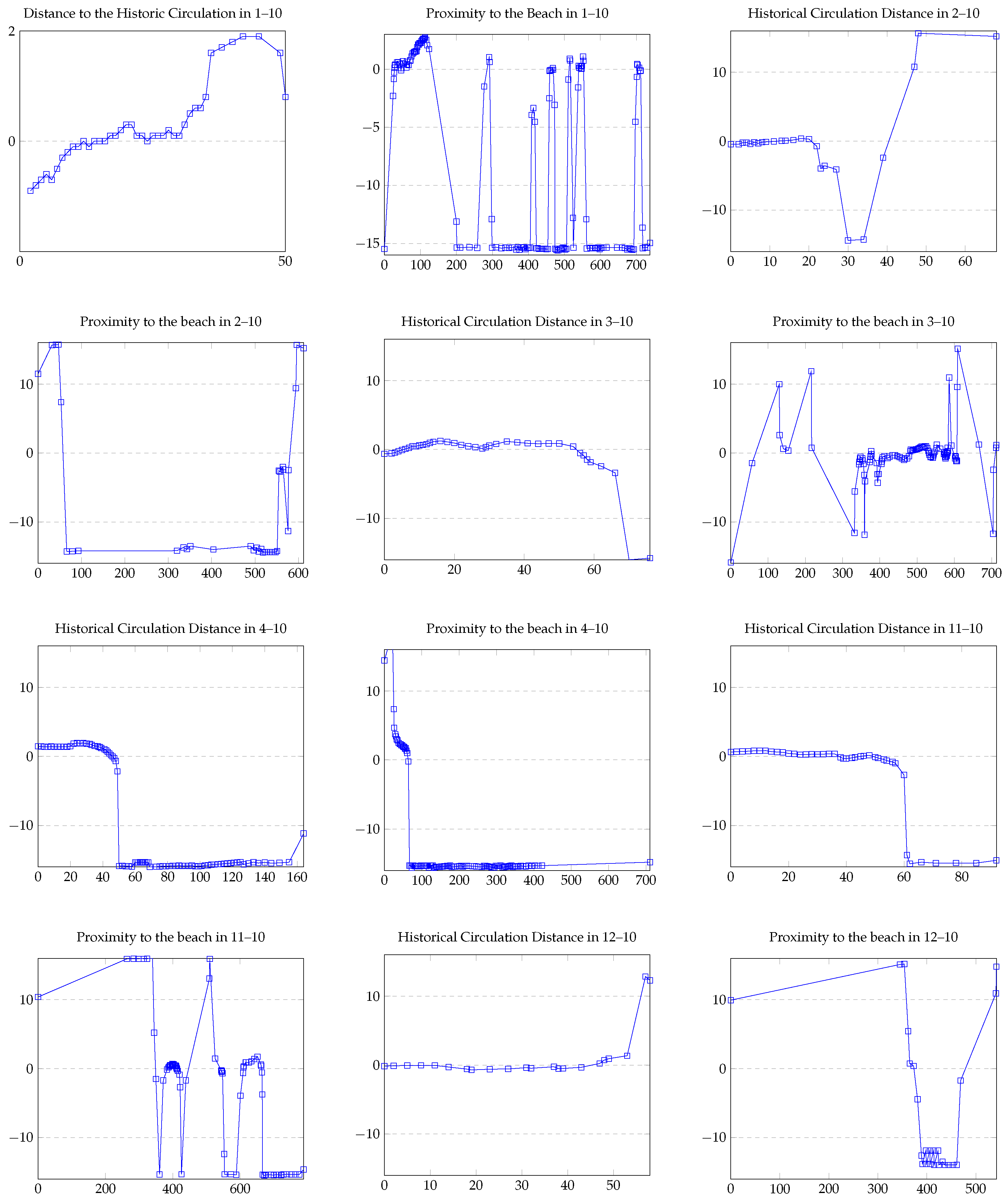
3.3.1. Study of the Influence of Variables on Land-Use Changes

Below, the influence of different variables on land-use changes is studied using the weights of evidence graphs (see Figure 10). The assumption of factor independence was validated with the Cramer test. A complete analysis is made of the weights of evidence in all transitions. Table 3 shows this analysis in detail.
Proximity to the beach and regulations. The results indicate that, within a distance range from 88 to 110 m, the proximity to the beach promotes a change from HV to NUV. When comparing the land-use plans from 1992 to 2019, it is observed that HV located in this range (northern sector of the study area, Figure 5) effectively changes in a lot-by-lot process to NUV. On the other hand, the proximity of the beach does not increase the probability of change in the range from 10 m to 88 m. This is confirmed by observing that the changes that HV undergoes in that distance range are effectively not to NUV but to a New Mixed Use (19) of a gastronomic commercial type.
The weights of evidence map identifies the areas that have changed from HV to NUV regarding the beach (Figure 11). Finally, the results indicate that for a range between 300 and 600 m variations in the distance to the beach do not affect the probability of change from HEAI (3) to NUV (10). As for the change from HP to NUV, this seems driven by two variables: the variable proximity to the beach and within the urban renewal zone (CES), and it is also clearly inhibited by the Historical Monuments protection instrument. The effect of these variables is consistent with what was stated in the historical introduction.
Circulation routes. The results indicate that distances under 14 m from traffic routes decrease the probability of change from HV(1) to NUV(10). From 14 m to approximately 30 m, the proximity of the roads does not affect the change. On the other hand, the presence of roads increases the probability of change at greater distances. This can be explained by the fact that the most significant number of roads is in the HCA.
Regulation. The changes from HV (1) to NUV (10) show that the historical housing inside the HCA has 3.54 times less probability of change than the HV outside this polygon. For the change from HP (4) to NUV (19), it is observed that the area protected under the HM figure decreases the probability of change nineteen-fold compared to the unprotected area. This factor does not affect the change from HEAI to NUV since no areas with this use are protected.

3.3.2. Correlation Analysis and Map Probability

Cramer’s test gives low values, so, in principle, there is not much association between the categorical variables. In this way, the probability and prediction map can be generated. For this, a Patcher-type cellular automaton whose parameters are fixed is used. Mean Patch Size is used with 1.0, variance with 0.1 and isometry with 1.0. The result is two maps: a change probability map, and a prediction map (estimation of a map based on the original and considering the transitions and values explained above). The probability map is shown in Figure 12.
Once the probability and prediction maps are obtained, the model can be calibrated by calculating the similarity between the prediction map and the observed one. First, the similarity is calculated graphically and spatially. Before obtaining similarity between maps, two maps are observed. Land type 10 is used for each map: the original of 2019 and the simulated one, while also looking at the evolution since 1992. The result is quite promising since similar maps are obtained. The similarity using just land type 10, is seen in Figure 13.
It can be noted that there is a close similarity between the prediction map and the observed one. Next, a more detailed analysis of the similarity is made. This was checked with the diffuse similarity indices, which indicates a similarity of around 99% (Figure 13).

3.3.3. Projecting Future Scenarios

This result allows using the prediction to make a projection since there is a reasonable estimate of the neighborhood’s future and what will happen with new housing use. Thus, a projection for 2030 is made to estimate what might happen regarding new housing use in the future. A probability map and a 2030 map are calculated for this (Figure 12), and a prediction for the future of the Bellavista neighborhood and the type of new housing land use are made for 2050 and 2100 (Figure 14). The trend is clearly of urban sprawl near the beach and close to the main roads.

3.4. Discussion

The results show significant changes in land use, driven by both state and individual actions. From 1970 to 1992, informal open spaces displayed fragility, giving way to low-rise residential expansion. This trend persisted from 1992 to 2019, leading to the almost total loss of informal open spaces and the dominance of new housing.
Distinct trends emerged between the coastal edge and the interior of the neighborhood. The coastal strip’s proximity to the beach drove changes from historical housing to mixed uses, aligning with the global trend of heritage sites being repurposed for tourism development [4,5]. Additionally, the state’s collaboration with companies influenced the conversion of historical factory fabric to high-rise housing.
The presence of informal open spaces inside the neighborhood facilitated the expansion of low-rise housing. At the same time, the HCA polygon’s definition inhibited change. These findings reflect broader challenges in reconciling urban development with heritage conservation, as discussed by [7].
The spatio-temporal prediction model developed in this study is highly accurate (fuzzy similarity index 0.99) and is a significant tool for forecasting future changes and planning heritage conservation. It resonates with advancements in urban simulation models [13,15,17].

4. Conclusions and Future Work

In this work, we have examined the influence of morphological factors and urban management instruments on the industrial heritage conservation process. To achieve this, we proposed a new methodology consisting of three phases: digitization, exploratory spatial data analysis and simulation.
For the digitization phase, we created a series of digital maps of the Industrial Bellavista neighborhood in southern Chile, categorized by lots for the years 1970, 1992 and 2019. During the exploratory spatial data analysis phase, we utilized spatial statistical techniques to examine the primary changes between these periods and articulated the main trends in a comprehensible manner. In the final simulation phase, we developed and calibrated a spatio-temporal prediction model using DINAMICA EGO, incorporating weights of evidence and cellular automata.
While our proposed methodology is designed for general cases, its primary limitation lies in its context-dependence. The transformation of historic neighborhoods is influenced by unique contextual factors, meaning that models developed for one case study may not be readily applicable to others. Consequently, for future works, it is crucial to focus on the adaptability and generalization of these models to derive broader and more relevant conclusions.
Our research demonstrates that land-use change models can be effectively utilized at smaller scales than typically employed. Furthermore, our methodology is adaptable to other case studies aimed at examining the impact of specific factors on territorial changes. This approach can significantly enhance urban planners’ decision-making processes when developing conservation policies.

Author Contributions

Conceptualization, M.I.L. and C.R.-M.; methodology, P.G.-A., M.I.L. and C.R.-M.; software, P.G.-A., P.C. and C.R.-M.; validation, P.G.-A., M.I.L., P.C. and C.R.-M.; formal analysis, P.G.-A., M.I.L., P.C. and C.R.-M.; investigation, P.G.-A., M.I.L., P.C. and C.R.-M.; resources, P.G.-A., M.I.L., P.C. and C.R.-M.; data curation, P.G.-A., P.C. and C.R.-M.; writing—original draft preparation, P.G.-A., M.I.L., P.C. and C.R.-M.; writing—review and editing, P.G.-A., M.I.L. and C.R.-M.; visualization, P.G.-A., M.I.L., P.C. and C.R.-M.; supervision, P.G.-A., M.I.L., P.C. and C.R.-M.; project administration, P.G.-A., M.I.L., P.C. and C.R.-M.; funding acquisition, P.G.-A. and M.I.L. All authors have read and agreed to the published version of the manuscript.

Funding

This research was funded by the Agencia Nacional de Investigación y Desarrollo (ANID) with the project FONDECYT REGULAR N°1190992 and the Universidad Adventista de Chile through the Regular Research Project PI 207.

Institutional Review Board Statement

Not applicable.

Informed Consent Statement

Not applicable.

Data Availability Statement

All data or models that support the findings of this study are available from the corresponding author upon reasonable request.

Acknowledgments

The authors would like to thank the PhD Program of Economics and Information Management (Faculty of Business Science—University of Bío-Bío).

Conflicts of Interest

The authors declare no conflicts of interest.

References

  1. Heritage Tourism Market Size, Share & Trends Analysis Report. 2022. Available online: https://www.grandviewresearch.com/industry-analysis/heritage-tourism-market-report (accessed on 6 July 2022).
  2. Hernández, J.; Moyano, A. Patrimonio Cultural, Movimientos sociales y Construcción de la Identidad en Andalucía, Memoria Proyecto de Investigación 2006, Centro de Estudios Andaluces Patrimonio Cultural, Movimientos Sociales y Construcción de la Identidad, 2007, 52. Available online: https://centrodeestudiosandaluces.es/datos/paginas/proyectos06/ATL063.pdf (accessed on 6 June 2022).
  3. Maillard, C. Construcción social del patrimonio. In Hecho en Chile. Reflexiones en Torno al Patrimonio Cultural; Marsal, E.D., Ed.; Consejo Nacional de la Cultura y las Artes: Santiago, Chile, 2012; pp. 15–33. [Google Scholar]
  4. Berger, S.; Wicke, C. Introduction: Deindustrialization, Heritage, and Representations of Identity. Public Hist. 2017, 39, 10–20. [Google Scholar] [CrossRef]
  5. Cole, D. Exploring the sustainability of mining heritage tourism. J. Sustain. Tour. 2004, 12, 480–494. [Google Scholar] [CrossRef]
  6. Homobono, J. Del patrimonio cultural al industrial: Una mirada socioantropológica. In Patrimonios Culturales: Educación e Interpretación. Cruzando líMites y Produciendo Alternativas; Pereiro, E.X., Prado, S., Takenaca, H., Eds.; Ankulegi: San Sebastian, España, 2008; pp. 57–74. Available online: https://www.researchgate.net/publication/46389052_Del_patrimonio_cultural_al_industrial_Una_mirada_socioantropologica (accessed on 8 July 2022).
  7. UNESCO World Heritage Centre. The UNESCO Recommendation on the Historic Urban Landscape, Report of the Second Consultation on its Implementation by Member States; UNESCO World Heritage Centre: Paris, France, 2019. [Google Scholar]
  8. Ripp, M.; Rodwell, D. The geography of urban heritage. Hist. Environ. Policy Pract. 2015, 6, 240–276. [Google Scholar] [CrossRef]
  9. Capel, H. La Morfología de las Ciudades, Cap. III Agentes urbanos y Mercado Inmobiliario. Ediciones Del Serbal, Barcelona, España 2013. p. 461. Available online: https://www.scribd.com/document/484306437/Capel-Horacio-La-morfologi-a-de-las-ciudades-III-Agentes-urbanos-y-mercado-inmobiliario (accessed on 15 June 2022).
  10. Whitehand, J.W.R. British urban morphology: The Conzenion tradition. Urban Morphol. 2001, 5, 103–109. [Google Scholar] [CrossRef]
  11. Nikologianni, A.; Moore, K.; Larkham, P.J. Making sustainable regional design strategies successful. Sustainability 2019, 11, 1024. [Google Scholar] [CrossRef]
  12. Abdullahi, S.; Pradhan, B.; Mansor, S.; Shariff, A.R.M. GIS-based modeling for the spatial measurement and evaluation of mixed land use development for a compact city. GIScience Remote Sens. 2015, 52, 18–39. [Google Scholar] [CrossRef]
  13. Zhang, D.; Liu, X.; Wu, X.; Yao, Y.; Wu, X.; Chen, Y. Multiple intra-urban land use simulations and driving factors analysis: A case study in Huicheng, China. GIScience Remote Sens. 2019, 56, 282–308. [Google Scholar] [CrossRef]
  14. Wu, R.; Wang, J.; Zhang, D.; Wang, S. Identifying different types of urban land use dynamics using Point-of-interest (POI) and Random Forest algorithm: The case of Huizhou, China. Cities 2021, 114, 103202. [Google Scholar] [CrossRef]
  15. França, D.G.M.; Lotte, R.G.; de Almeida, C.M.; Siani, S.M.O.; Körting, T.S.; Fonseca, L.G.M.; da Silva, L.T. Object-based image analysis for urban land cover classification in the city of Campinas-SP, Brazil. In 2015 Joint Urban Remote Sensing Event; IEEE: Piscataway, NJ, USA, 2015; pp. 1–4. [Google Scholar]
  16. Naikoo, M.W.; Rihan, M.; Shahfahad; Peer, A.H.; Talukdar, S.; Mallick, J.; Ishtiaq, M.; Rahman, A. Analysis of peri-urban land use/land cover change and its drivers using geospatial techniques and geographically weighted regression. Environ. Sci. Pollut. Res. 2023, 30, 116421–116439. [Google Scholar] [CrossRef]
  17. Azari, M.; Tayyebi, A.; Helbich, M.; Reveshty, M.A. Integrating cellular automata, artificial neural network, and fuzzy set theory to simulate threatened orchards: Application to Maragheh, Iran. GIScience Remote Sens. 2016, 53, 183–205. [Google Scholar] [CrossRef]
  18. Chen, Y.; Li, X.; Liu, X.; Ai, B. Modeling urban land-use dynamics in a fast developing city using the modified logistic cellular automaton with a patch-based simulation strategy. Int. J. Geogr. Inf. Sci. 2014, 28, 234–255. [Google Scholar] [CrossRef]
  19. He, J.; Huang, J.; Li, C. The evaluation for the impact of land use change on habitat quality: A joint contribution of cellular automata scenario simulation and habitat quality assessment model. Ecol. Modell. 2017, 366, 58–67. [Google Scholar] [CrossRef]
  20. Jokar Arsanjani, J.; Helbich, M.; Kainz, W.; Boloorani, A.D. Integration of logistic regression, Markov chain and cellular automata models to simulate urban expansion. Int. J. Appl. Earth Obs. Geoinf. 2013, 21, 265–275. [Google Scholar] [CrossRef]
  21. Lagarias, A. Urban sprawl simulation linking macro-scale processes to micro-dynamics through cellular automata, an application in Thessaloniki, Greece. Appl. Geogr. 2012, 34, 146–160. [Google Scholar] [CrossRef]
  22. Ma, J.; Hipel, K.W.; Hanson, M.L.; Cai, X.; Liu, Y. An analysis of influencing factors on municipal solid waste source-separated collection behavior in Guilin, China by Using the Theory of Planned Behavior. Sustain. Cities Soc. 2018, 37, 336–343. [Google Scholar] [CrossRef]
  23. Al-shalabi, M.; Billa, L.; Pradhan, B.; Mansor, S.; Al-Sharif, A.A.A. Modelling urban growth evolution and land-use changes using GIS based cellular automata and SLEUTH models: The case of Sana’a metropolitan city, Yemen. Environ. Earth Sci. 2013, 70, 425–437. [Google Scholar] [CrossRef]
  24. Morshed, S.R.; Fattah, M.A.; Hoque, M.M.; Islam, M.R.; Sultana, F.; Fatema, K.; Rabbi, M.F.; Rimi, A.A.; Sami, F.Y.; Rezvi Amin, F.M. Simulating future intra-urban land use patterns of a developing city: A case study of Jashore, Bangladesh. GeoJournal 2023, 88, 425–448. [Google Scholar] [CrossRef]
  25. Simwanda, M.; Murayama, Y.; Phiri, D.; Nyirenda, V.R.; Ranagalage, M. Simulating scenarios of future intra-urban land-use expansion based on the neural network–Markov model: A case study of Lusaka, Zambia. Remote Sens. 2021, 13, 942. [Google Scholar] [CrossRef]
  26. Mitsova, D.; Shuster, W.; Wang, X. A cellular automata model of land cover change to integrate urban growth with open space conservation. Landsc. Urban Plan. 2011, 99, 141–153. [Google Scholar] [CrossRef]
  27. Cao, J.; Li, T. Analysis of spatiotemporal changes in cultural heritage protected cities and their influencing factors: Evidence from China. Ecol. Indic. 2023, 151, 110327. [Google Scholar] [CrossRef]
  28. Meles, T.H.; Mekonnen, A.; Beyene, A.D.; Hassen, S.; Pattanayak, S.K.; Sebsibie, S.; Klug, T.; Jeuland, M. Households’ valuation of power outages in major cities of Ethiopia: An application of stated preference methods. Energy Econ. 2021, 102, 105527. [Google Scholar] [CrossRef]
  29. Jokar Arsanjani, J.; Helbich, M.; Bakillah, M.; Hagenauer, J.; Zipf, A. Toward mapping land-use patterns from volunteered geographic information. Int. J. Geogr. Inf. Sci. 2013, 27, 2264–2278. [Google Scholar] [CrossRef]
  30. de Almeida, C.M.; Gleriani, J.M.; Castejon, E.F.; Soares-Filho, B.S. Using neural networks and cellular automata for modelling intra-urban land-use dynamics. Int. J. Geogr. Inf. Sci. 2008, 22, 943–963. [Google Scholar] [CrossRef]
  31. Mas, J.F.; Pérez-Vega, A.; Clarke, K.C. Assessing simulated land use/cover maps using similarity and fragmentation indices. Ecol. Complex. 2012, 11, 38–45. [Google Scholar] [CrossRef]
  32. Shahfahad; Naikoo, M.W.; Das, T.; Talukdar, S.; Asgher, M.S.; Asif; Rahman, A. Prediction of land use changes at a metropolitan city using integrated cellular automata: Past and future. Geol. Ecol. Landsc. 2022, 1–19. [Google Scholar] [CrossRef]
  33. Brito, A.; Cerda, G.; Fuentes, P.; Pérez, L.; Ambrosetti, D.; Barría, T.; Becerra, M.; Bustos, A.; Cvitanic, D.; Figueroa, N.; et al. Industria y Habitar Colectivo. Conjuntos habitacionales en el sur de Chile; Editorial STOQ: Concepción, Chile, 2018; p. 176. [Google Scholar]
  34. Montory, A.C.; Luppi S.M., R.; López, T.L. Bellavista Oveja Tomé. Una Fábrica en el Tiempo; Ediciones Universidad de San Sebastián: Concepción, Chile, 2012; Available online: https://www.researchgate.net/publication/338717831_Bellavista_Oveja_Tome_Una_fabrica_en_el_tiempo (accessed on 6 June 2020).
  35. Herrera Ojeda, R.; Lopez Meza, M.I.; Morajes Ortiz, M.F. Procesos contemporáneos de activación patrimonial: Tensiones, disputas y consensos entre las comunidades, El caso de Bellavista en Tomé, Chile. Atenea 2021, 524, 195–217. [Google Scholar] [CrossRef]
  36. Matus Madrid, C.; Zúñiga-Becerra, P.; Pérez-Bustamante, L. Patrimonialización de sitios industriales textiles: Más de una década de puesta en valor por las comunidades de Tomé. Sophia Austral 2019, 23, 235–256. [Google Scholar] [CrossRef]
  37. Hübscher, M.; Ringel, J. Opaque Urban Planning. The Megaproject Santa Cruz Verde 2030 Seen from the Local Perspective (Tenerife, Spain). Urban Sci. 2021, 5, 32. [Google Scholar] [CrossRef]
  38. Lange, D.; Wang, D.; ‘Mark’ Zhuang, Z.; Fontana, W. Brownfield development selection using multiattribute decision making. J. Urban Plan. Dev. 2014, 140, 04013009. [Google Scholar] [CrossRef]
  39. Agterberg, F.P.; Bonham-Carter, G.F. Deriving weights of evidence from geoscience contour maps for the prediction of discrete events. In Proceedings of the 22nd APCOM Symposium, Berlin, Germany, 17–21 September 1990; Volume 2, pp. 381–395. [Google Scholar]
  40. Bonham-Carter, G. Geographic Information Systems for Geoscientists: Modelling with GIS; Elsevier: Amsterdam, The Netherlands, 1994. [Google Scholar]
  41. Piontekowski, V.; da Silva, S.; Mendoza, E.; de Souza Costa, W.; Ribeiro, F.; Ribeiro, C. Modelagem do Desmatamento para o Estado do Acre Utilizando o Programa DinamicaEGO. Embrapa Informática Agropecuária/INPE, Bonito, Brazil 2012. pp. 1064–1075. Available online: https://www.geopantanal.cnptia.embrapa.br/2012/cd/p183.pdf (accessed on 6 June 2020).
  42. Godoy, M.; Soares-Filho, B.S. Modelling intra-urban dynamics in the Savassi neighbourhood, Belo Horizonte city, Brazil. In Modelling Environmental Dynamics; Springer: Berlin/Heidelberg, Germany, 2008; pp. 319–338. [Google Scholar]
Figure 1. Polygon of study within the Concepción Metropolitan Area (CMA).
Applsci 14 07221 g001
Figure 2. Distance variables. On the (left) is the distance to the historical vehicle traffic route and on the (right) is the distance to the beach. Bluer equals closer and redder farther away.
Applsci 14 07221 g002
Figure 3. Categorical variables where the variables’ location is indicated in red: Historical Monument (HM), Coastal Edge Section Plan (CES) and Historical Conservation Area (HCA).
Applsci 14 07221 g003
Figure 4. Creation phases of a spatio-temporal simulation model.
Applsci 14 07221 g004
Figure 7. Percentage of land use per year.
Applsci 14 07221 g007
Figure 8. Percentage of change in historical land uses of Equipment (HE), Informal Open Spaces (HEAI) and Housing (HV) to New Uses from 1970 to 1992, New Housing Use (NUV), Brownfields (SE), New Equipment Use (NUE) and New Circulation Space Use (NUEC).
Applsci 14 07221 g008
Figure 9. Percentage of land-use change from 1992 to 2019.
Applsci 14 07221 g009
Figure 10. Weights of evidence for distance to the historic circulation and distance to the beach.
Applsci 14 07221 g010
Figure 11. (Left) The weights of evidence are shown alongside the 1992—HV and 2019—NUV land-use maps. (Right) The weights of evidence of the Distance to Historical Circulation Space variable are shown alongside the land-use maps of 1991—HV and 2019—NUV.
Applsci 14 07221 g011
Figure 12. Probability map for 2019 (Left) and probability map for 2030 (Right).
Applsci 14 07221 g012
Figure 13. Original and prediction maps for 2019 and similarity between that predicted for 2019 and the original for type NUV.
Applsci 14 07221 g013
Figure 14. Projecting future scenarios for 2050 and 2100 from the artificial map of 2019 generated by the simulation model.
Applsci 14 07221 g014
Table 1. Urban simulation models.
ApproachArticleModelScaleResolution
Land-Use Change[12]WoE-MCDARegion5 m
[13]RF-CAIntra-urban10 m
[14]RF-CAIntra-urban30 m
[15]ANN-CAIntra-urban50 m
[16]RF-MCDA-FuzzyRegion30 m
[17]CA-ANN-FuzzyRegion30 m
[18]Patch-LR-CARegion30 m
Urban Growth[19]AIS-CARegion30 m
[20]LR-MC-CARegion30 m
[21]LR-CARegion25 m
[22]GRADIANTE-CANational100 m
Both[23]CA-SleuthRegion45 m
[24]MLC-MC-CA-MPNNMCIntra-urban10 m
[25]MC-CAIntra-urban30 m
[26]MC-CARegion10 m
Table 2. Transition matrix from 1970 to 1992.
1992
1970NUVSE NUENUECTotal
HV0.03%0.02%0.02%0.00%0.07%
HEAI1.36%1.12%0.00%0.22%2.70%
HE0.00%0.00%1.40%0.00%1.40%
Table 3. Probability of change as a function of the different variables calculated with the weights of evidence method from the images and data presented in Figure 10.
Change of UseBeach Distance VariableHistoric Circulation Distance VariableHistorical Monument (HM)Historical Conservation Area (HCA)Coastal Edge Section Plan (CES)
HV (1) to NUV (10)0 to 24 mts decreases the probability of change; from 24 to 200 mts slightly increases the probability of change; from 200 the probability of change begins to decrease0 to 17.4 mts decreases the probability of change; from 17.4 to 29 slightly increases the probability of change; from 29 greatly increasesIt is not associated (there is no evidence that it increases or decreases)Not protected increases slightly (0.65); protected decreases probability (−3.54)Not associated
HE (2) to NUV (10)0 to 66 increases the probability of change; 66 to 594 decreases the probability of change; from 594 increases the probability of change0 to 22 is not associated; 22 to 47 decreases; from 47 the probability of change increasesNot associatedNot protected probability of change increases by 3.73; the probability of change decreases by −17.35Non-urban renewal decreases probability (−1.18), urban renewal increases the probability of change (17.01)
HEAI (3) to NUV (10)0 to 130 mts decreases the probability of change; 608 to 666 there is a striking increase in the probability0 to 6 mts decreases the probability; 6 to 56 slightly increases the probability of change; from 56, it decreasesNot associatedNot protected not associated; protected increases the probability of change (1.9)Not associated
HP (4) to NUV (10)0 to 67 increases the probability of change; from 67 decreases the probability of change0 to 49 slightly increases the probability of change; from 49 the probability of change begins to decreaseUnprotected increases probability (5.0), protected decreases probability (weight −19)Not associatedNo urban renewal repels (−19), urban renewal favors change (+19)
SE (11) to NUV (10)From 0 to 350, it increases; 350 to 383, it decreases; 383 to 422, it increases slightly; from 422 to 509 it decreases; 509 to 559: from there it decreasesFrom 0 to 50 it increases very slightly and then decreases very slightly; from 50, the probability of change decreasesNot associatedUnprotected decreases (−0.1); protected favors increases (1.13)Not associated
NUE (12) to NUV (10)Up to 381, the probability of change increases; from 381 to 541, it decreases; from 541, the probability increasesIt is not associated until 49; from there the probability begins to increaseNot associatedUnprotected increases probability (14.82); protected decreases (−0.21)Not associated
Disclaimer/Publisher’s Note: The statements, opinions and data contained in all publications are solely those of the individual author(s) and contributor(s) and not of MDPI and/or the editor(s). MDPI and/or the editor(s) disclaim responsibility for any injury to people or property resulting from any ideas, methods, instructions or products referred to in the content.

