Article

GIS-Based Agricultural Land Use Favorability Assessment in the Context of Climate Change: A Case Study of the Apuseni Mountains

1
Faculty of Agriculture, University of Agricultural Sciences and Veterinary Medicine Cluj-Napoca, 400372 Cluj-Napoca, Romania
2
Faculty of Geography, Babes-Bolyai University, Clinicilor Street 5-7, 400006 Cluj-Napoca, Romania
3
Academy of Romanian Scientists, Ilfov 3, 050044 Bucharest, Romania
4
Cluj-Napoca Subsidiary Geography Section, Romanian Academy, 400015 Cluj-Napoca, Romania
5
Faculty of Environmental Protection, University of Oradea, 26 Gen. Magheru Street, 410048 Oradea, Romania
6
Department of Pedotechnics, Faculty of Agriculture, Iasi University of Life Sciences, 3 Sadoveanu Alley, 700490 Iaşi, Romania
*
Authors to whom correspondence should be addressed.
Appl. Sci. 2024, 14(18), 8348; https://doi.org/10.3390/app14188348
Submission received: 29 August 2024 / Revised: 13 September 2024 / Accepted: 14 September 2024 / Published: 17 September 2024
(This article belongs to the Special Issue Novel GIS Tool for Soil Research)

Abstract

:
With an emphasis on the effects of climate change, this study offers a thorough GIS-based assessment of land use favorability in the Apuseni Mountains. The Apuseni Mountains, a region characterized by its biodiversity and complex terrain, are increasingly vulnerable to the impacts of climate change, which threaten both natural ecosystems and human activities. The territory of 11 territorial administrative units was selected for the investigation because it shows more of an anthropogenic influence due to the migration of people to mountainous areas following the COVID-19 pandemic, which increased the amount of anthropogenic pressure in this area. Factors that describe the climate of the study area, the soil characteristics, and the morphometric characteristics of the relief were used to create a classification for the present on classes of favorability and restrictiveness for the plots of land, using a quantitative GIS model to determine the favorability of the land for the main crops and agricultural uses. The current land favorability was thus initially obtained, taking into account current temperature and precipitation values and using the SSP1-1.9, SSP1-2.6, SSP2-4.5, SSP3-7.0, and SSP5-8.5 scenarios for the 2020–2099 time frame. The results indicate a variation in the statistical classification of the land for different favorability classes, a decrease of 4.7% for the high favorability class for pastures, an estimated decrease of 4.4% for grassland, and in the case of orchards, the situation reflects a fluctuating variation. There is a decrease of 6.4% in the case of the very low favorability class according to SSP2-4.5 (in the case of reaching an average temperature of 12.7 °C and an annual precipitation of 895 mm), and in case of high and very high favorability, there is an increase in plots falling into better high favorability classes of up to 0.7%.

1. Introduction

Land use classes are closely connected with both local and regional climatic conditions, demonstrating the delicate interaction between natural components of the environment and human activity [1,2,3]. Climate variables such as temperature, precipitation, and seasonal patterns have a significant impact on the distribution and features of various land uses [4,5,6], including agricultural areas [7,8,9,10], forests [11,12], urban spaces, and water bodies [13,14,15]. Climatic considerations play a crucial role in determining the suitability of specific regions for different land uses, impacting the growth of crops, the density of forests, and the availability of water supplies [16,17]. Nevertheless, the influence of climate on land utilization is not fixed; it transforms in response to evolving climatic conditions, such as those caused by global climate change [18,19,20]. Consequently, changes in temperature, patterns of precipitation, and occurrences of extreme weather events are anticipated to modify the way land is used, requiring the implementation of adaptive management measures [21,22].
Research conducted at a global or detailed level has highlighted the impacts of global warming such as the decline in biodiversity, an increased susceptibility to wildfires, and structural changes in ecosystems; excessive heat can harm crops by diminishing photosynthesis [23,24,25], influencing the growth of fruits [26], or inducing heat-related illnesses [27,28], resulting in decreased yields [29]. Certain crops can experience accelerated maturation [30], resulting in encounter delays that disturb the timing of planting and harvesting [31,32].
Global warming causes a rise in mean global temperatures, which can disturb ecosystems [33,34], modify habitats [35], and endanger biodiversity as compared to other scenarios [36]. Global warming perturbs natural weather patterns, resulting in heightened storm intensity [37], extended periods of drought, and irregular precipitation patterns [38,39,40,41,42], therefore impacting agriculture and available water resources [43]. Increasing temperatures and arid conditions amplify the occurrence and intensity of wildfires [44], causing destruction to forests [45,46,47], emitting carbon, and endangering both animals and human communities [48]. Numerous species exhibit insufficient adaptability to changing climates [49,50], resulting in a decline in biodiversity, therefore undermining ecosystems and diminishing their ability to withstand future environmental pressures [51,52]. Species are migrating to new regions in response to temperature changes, which can cause ecosystem imbalances and lead to the extinction of less adaptable species [53,54].
Beyond climate, anthropogenic activities also have a significant impact. Human activities, such as agriculture, urbanization, deforestation, and industrial growth, position considerable pressure on land resources [55]. The need for natural resources, such as wood, minerals, and fertile land, motivates alterations in land use, frequently resulting in the transformation of natural environments into agricultural or urban zones. Hence, the impact of human activities on land utilization is projected to increase in the coming years, propelled by the escalating demand for natural resources, the expansion of urban areas, and rising population growth [56].
GIS-based models allow for the assessment of land suitability for different purposes by combining diverse environmental, socio-economic, and climatic aspects [57,58,59]. GIS-based assessments play an important role in determining the most suitable places for agriculture, forestry, and conservation in the context of climate change [60,61]. This technique allows the identification of land that indicates resilience to climatic impacts and supports the achievement of sustainable development initiatives [62,63].
This study focuses on a Geographic Information System (GIS)-based assessment of the suitability of land use in the Apuseni Mountains (specifically the Somesul Mic watershed), taking into account the changing limitations caused by climate change. This project aims to assess the suitability of diverse land parcels for different uses (pasture, grassland, orchards). Its objective is to provide a rational framework that can assist land use planning and policy-making in the region. By including climate scenarios in the GIS-based assessment, it becomes possible to conduct a proactive study that confirms land use decisions are not only successful in the present, but also capable of coping with future climatic changes [64,65].
This study addresses two main research directions. The primary objective is to implement a GIS model to assess the suitability of the land in the research region for use as grassland, pasture, and orchards. This model utilizes a geodatabase that includes characteristics such as topography, soil type, climate variables, and water supplies, providing a precise evaluation of potential sites for different uses.
The second research direction is centered around analyzing the favorability classes of different land uses in the present day. The validation of the GIS model is achieved through a comparison with land parcels that are used according with the classification provided by the model. Furthermore, this study investigates modifications in favorability categories within the context of climate change, using a statistical analysis of the effects of the expected changes in average annual temperature and precipitation fluctuations for the time frame of 2020–2100.
A GIS land favorability assessment is based on a careful analysis of the environmental variables present in the research area. These conditions include factors like slope, altitude, temperature, and precipitation [66], as well as soil qualities such as texture, pH, gleiss, and useful edaphic volume [67].
The investigation of climate change in agriculture from an economic perspective is essential, as agriculture serves as the fundamental support system for many economies, especially in underdeveloped areas [68]. A decrease in crop production can result in an escalation in food costs, heightened volatility in the market, and inflation [69]. Inclement weather conditions such as droughts, heatwaves, and floods inflict direct harm upon crops and livestock, leading to substantial economic losses for farmers, governments, and the insurance industry [70]. A better understanding of climate-related risks allows for more accurate cost assessments and informed decision-making. If left unchecked, the cumulative effects of climate change on agriculture could lead to long-term economic decline, particularly in economies heavily dependent on agriculture [71]. This is why we consider a study such as this one useful, because it will provide a concrete picture of current agricultural suitability and model how this suitability will change in the future under climate change.

2. Methodology and Database
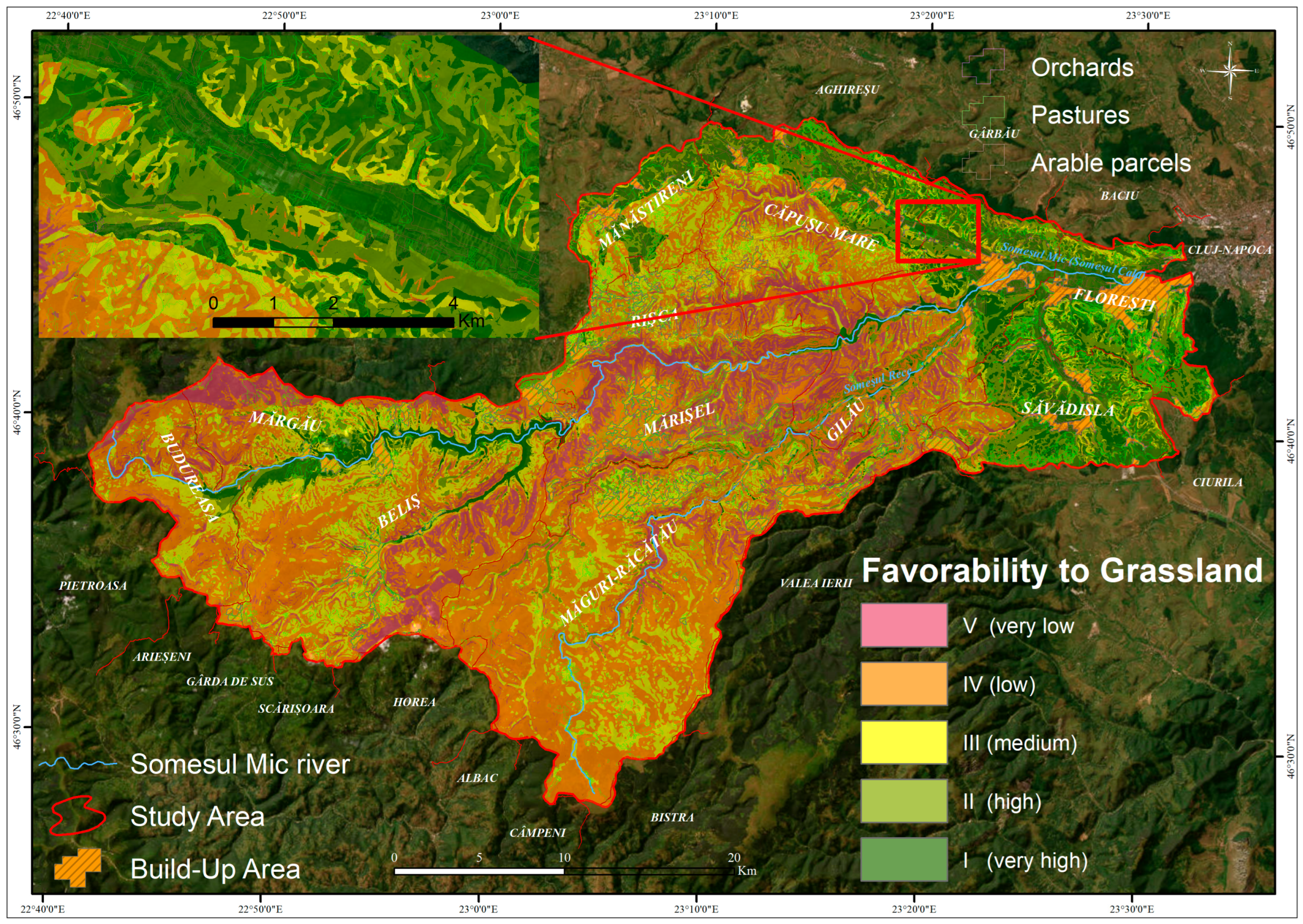
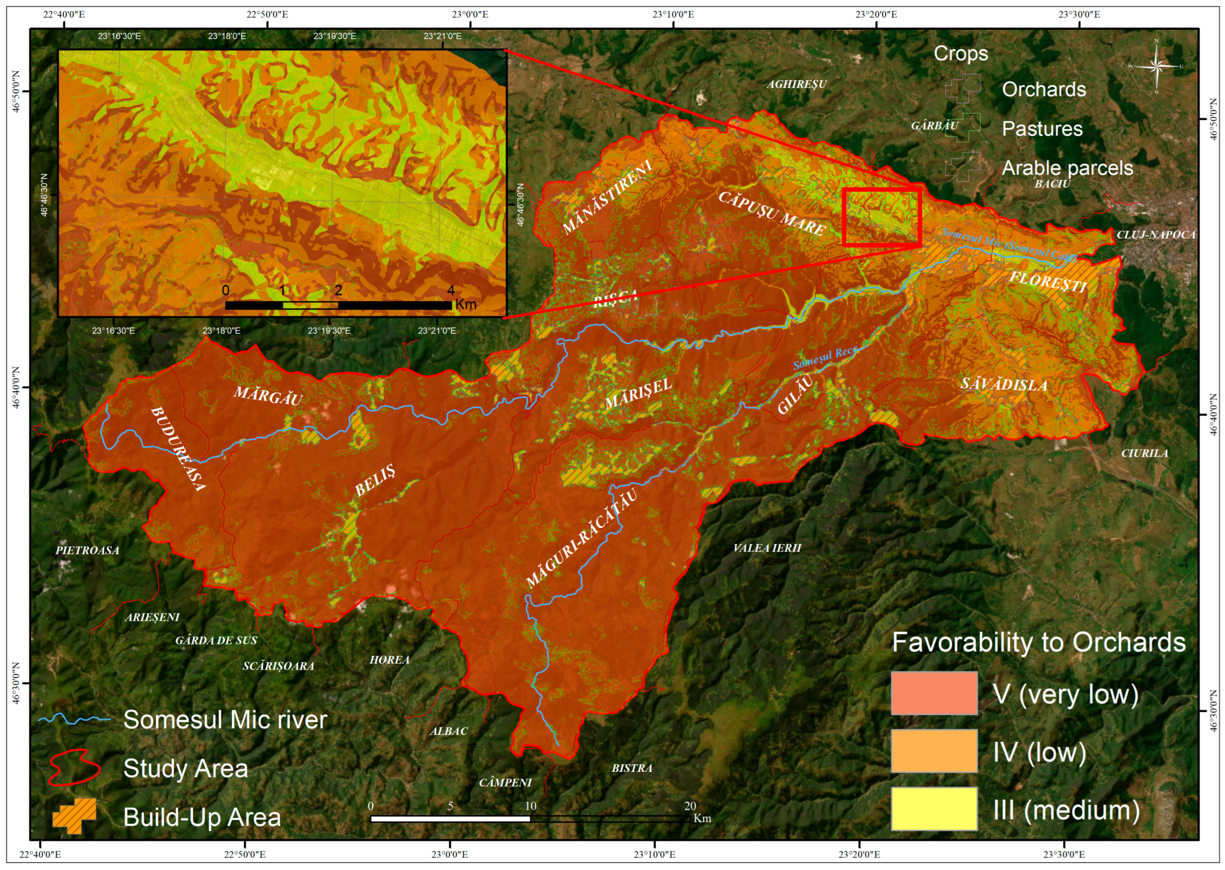
2.1. Study Area

The watershed chosen as the study area has a surface area of 1183.23 km2 and is located in the North-West Region of Romania, mostly in Cluj County (Figure 1). The upper Someș Mic watershed is located in the south-western part of Cluj County. From an administrative perspective, the study area comprises a series of 11 administrative territorial units (Beliș, Budureasa, Căpușu Mare, Florești, Gilău, Măguri-Răcătău, Mănăstireni, Mărgău, Mărișel, Rișca, and Săvădisla). The study area has a range of altitudes, with the lowest point being 360 m and the highest point being 1700 m. Within this range, there are different categories of hills and mountains. The area of low and medium hills, with altitudes between 360 and 500 m, covers 109.82 km2; the category of high hills, with altitudes between 501 and 750 m, covers 245.55 km2; the category of very high hills, with altitudes between 751 and 1000 m, covers 185.27 km2; and the category of low-altitude mountains, with altitudes between 1001 and 1500 m, covers 592.51 km2. The remaining 50.06 km2 falls within the category of medium-altitude mountains, with altitudes between 1501 and 1700 m.
The study area is characterized by steep slopes, with slope values between 11.25° and 22.5°, representing 35% of the entire area. The remainder of the study area is covered by moderately sloping slopes with values between 4.5° and 11.25°, representing 25%. Very steep slopes and horizontal slopes each account for 18% of the area. With the smallest percentages of 1% and 3%, respectively, are very gently sloping slopes, gently sloping slopes, and steep slopes.
As to mean annual temperatures, in the study area they vary between 1.6 °C and 9 °C. Temperatures below 6 °C are considered moderate, while temperatures above 6 °C are considered high and are suitable for agricultural practices in Romania. The multiannual mean precipitation within the study area ranges from 688 mm/yr to 1300 mm/yr. This value, which is considered average, is due to differences in elevation ranging from low and medium hills (360–500 m) to medium-elevation mountains (1501–2000 m). For the largest extent of the study area, the mean annual precipitation ranges from 1000.1 mm/yr to 1200 mm/yr, an area represented by low-altitude mountains. Therefore, the study area has a good water supply over most of the territory.
The study area is covered by a total of 18 soil types, categorized into 8 soil classes, each of which has different properties. From a pedological point of view, the analyzed territory presents soils of the Cambisols class on the largest area (722 km2, representing a percentage of 61% of the analyzed area) and soils of the Spodosols class on an area of 204 km2, representing 17%, and Clay-visols cover 114 km2 of the studied area (10%). The Antrisoils class represents 5%, occupying 59 km2. The Cernisols class occupies 4% (43 km2), and the additional class (Waters) 3% covers 38 km2, with the remaining area containing soils belonging to the Vertisols and Hidrisoils classes.
In the study area, forest vegetation occupies the largest portion, covering 62.64% of the total land. This forest is primarily a mix of coniferous and deciduous species, including Abies alba, Pinus sylvestris, Carpinus betulus, Populus alba, and Salix. Permanent grasslands account for 19.77% of the area, consisting of alpine and subalpine calcareous grasslands, rupicolous Pannonian grasslands, and basophilic grasslands from the Alysso-Sedion albi group. Unproductive lands, mainly covered by swamp vegetation, make up 6.89% of the total area. Arable lands, used for agriculture, occupy 5.17%. Built-up areas, classified under courtyards and constructions, account for 2.94% of the study region. The remaining 2.58% includes various categories such as permanent crops (excluding vineyards), orchards, hops, and fruit tree nurseries, as well as gravel, sand, rocks, sterile dumps, landfills, and roads. This diverse landscape reflects a combination of natural and human-modified land use patterns across the study area.

2.2. Database

The GIS database used for the current land cover framing contains both quantitative and qualitative vector, raster, and numerical (in the case of climate predictions) databases (Table 1).
Land assessment involves evaluating the capacity of land for multiple uses in order to anticipate the effects of any changes. Land suitability relates to the feasibility of a given area for a specific land utilization. If the landscape characteristics do not correspond to the specific needs of a certain land use, it might be considered a possible restriction [78]. Land assessment is an evaluative analysis of the suitability of the terrain utilized for agricultural purposes, considering the primary attributes of the land, which are influenced by factors such as topography, water features, climate, and soil conditions.
The initial step in the methodology involves acquiring raster-based databases, including the factors relevant to the model used to assess the suitability for various crops and agricultural uses (Stage I) (Figure 2).
In Stage II, the raster database is reclassified using values ranging from 0 to 1. Values closer to 0 indicate a low favorability for each range of each factor included in the modeling, while values closer to 1 indicate a high favorability for a range of a factor suitable for that use (Table 2).
Land evaluation was conducted using scoring under environmental conditions, which takes into account 8 factors: slope, mean annual temperatures, mean annual precipitation, gleiss, pseudogleiss, soil texture, soil edaphic volume, and soil reaction with a value from 0 to 1 according to the national methodology used in Romania [79,80]. The land rating by crop and land use is determined by multiplying the sum of the coefficients of the 8 indicators, as indicated by the following formula:
FI = (Sslope + Stemp + SPP + SG + SPS + Stext + SVol + SR) × 100,
where
  • FI—Favorability index;
  • Sslope—scoring value for slope;
  • Stemp—scoring value for average annual temperature;
  • SPP—scoring value for average annual precipitation;
  • SG—scoring value for soil gleiss;
  • SPS—scoring value for pseudogleiss;
  • Stext—scoring value for soil texture;
  • Svol—scoring value for soil edaphic value;
  • SR—scoring value for soil reaction.
Stage III consists of using Raster Calculator and ArcMap software (version 10.8) to calculate the favorability index, with values from 0–100 according to the methodological norms used in Romania [43]. The favorability results for the utilization of orchards (as a mean favorability for apple, pear, plum, cherry, cherry, apricot, and peach), pasture, and grassland are categorized into five favorability classes: class I (very high, 81–100 favorability points), class II (high, 61–80 favorability points), class III (medium, 41–60 favorability points), class IV (low, 21–40 favorability points), and class V (very low, 1–20 favorability points).
Within the category of limitations on production, even in regions with moderate to high favorability, there are locations affected by landslides or contamination of the soil. These have been employed to reduce the frequency of favorable categories. In the study region, there are a total of 113 mapped landslides, which include both shallow and deep-seated landslides. These landslides can be either active or stable, but they have resulted in limitations on land use. The methodology for classifying land in Romania by favorability classes [79,80,81] adapted the score of areas affected by soil pollution and landslides by 10% [82]. This adjustment allowed parcels of land affected by these natural and anthropogenic processes to be dropped from a higher-suitability class to a lower one in some instances, caused by their adverse impacts.
Stage IV consists of replacing the temperature and precipitation rasters with the SSP1-1.9, SSP1-2.6, SSP2-4.5, SSP3-7.0, and SSP5-8.5 scenarios for the time period of 2020–2099 [77]. The prediction models are then executed to assess the variations in favorability and restrictiveness inside the analyzed area over time, based on the expected climate condition changes. For the validation stage of the favorability model for the different land uses, the APIA 2023 utilization parcels will be used, which include parcels currently used as hay pasture, grassland, and fruit orchards. This type of validation is semi-quantitative, because it is not necessarily the case that a plot of land that has the highest favorability for orchards will be used as such, some areas being left unused even if the productivity would be good (Figure 2).

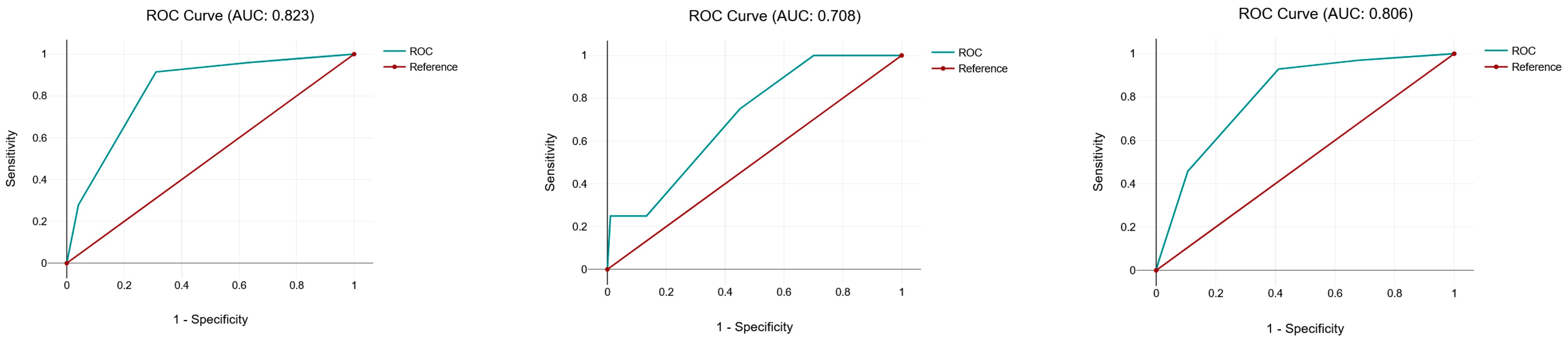
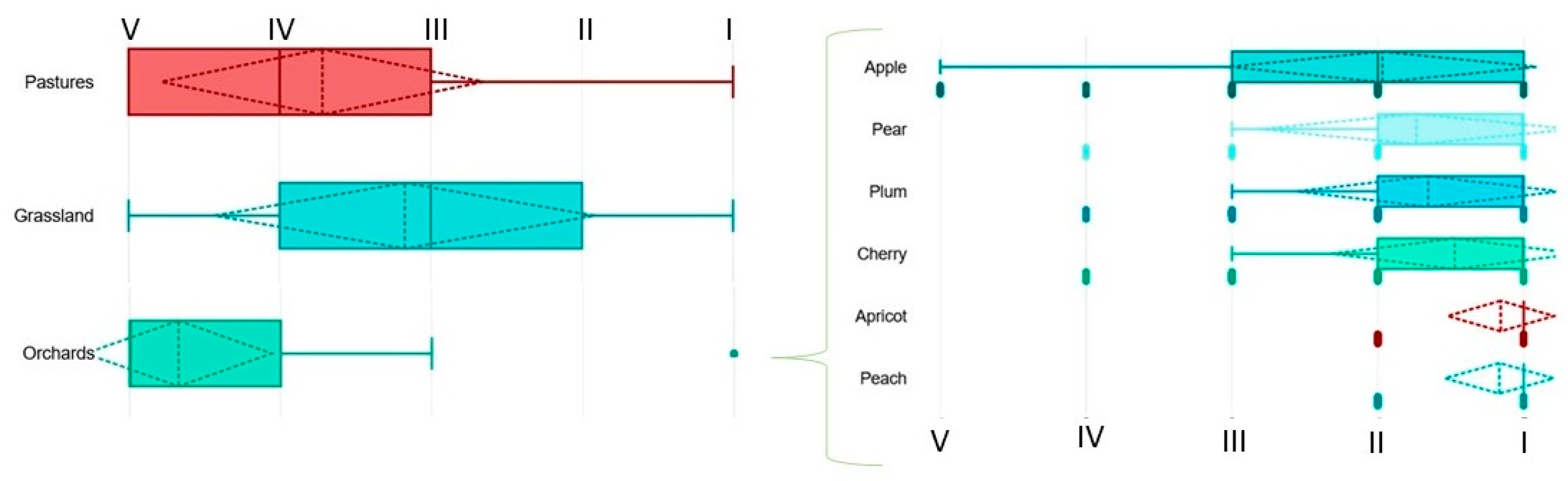
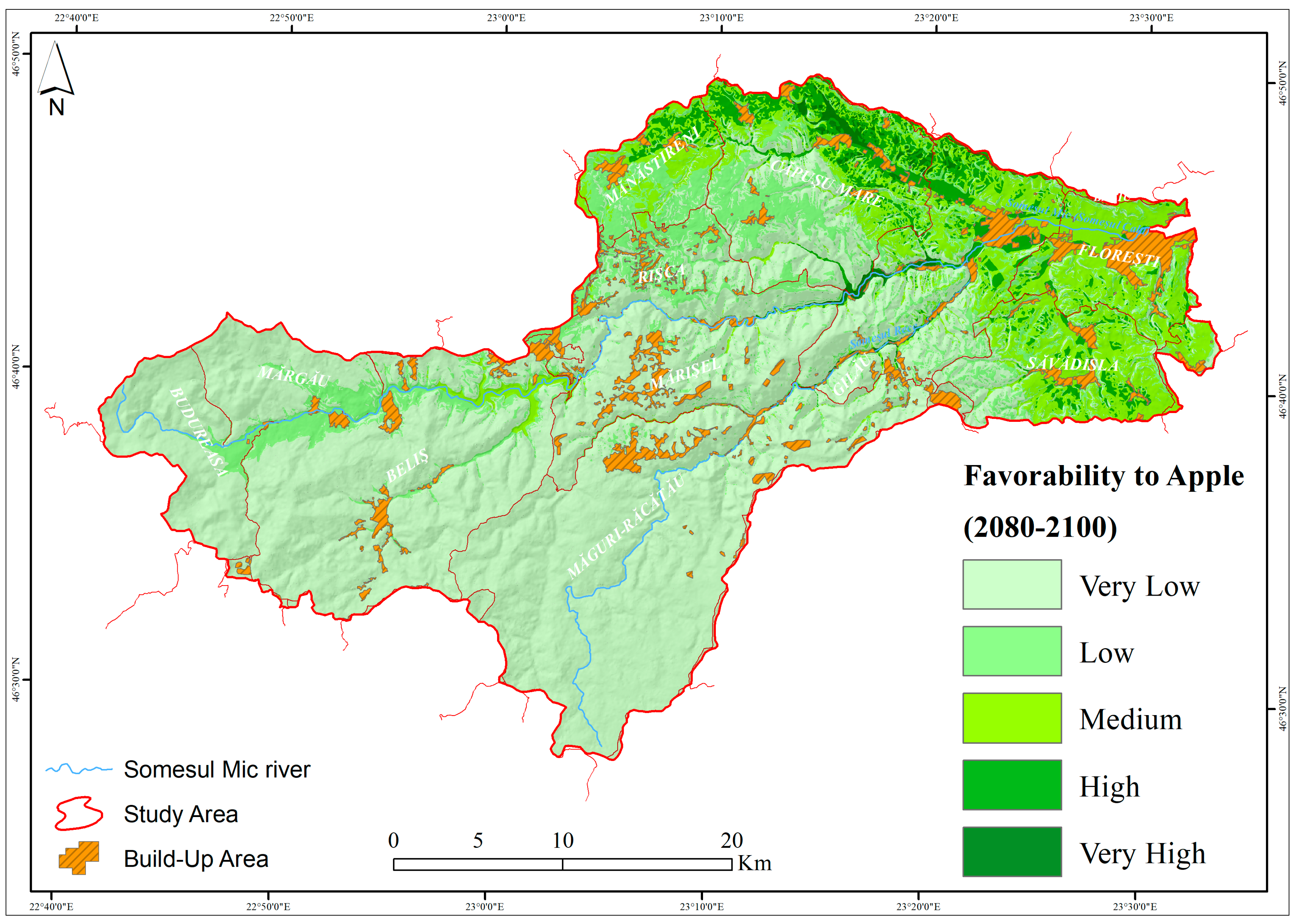
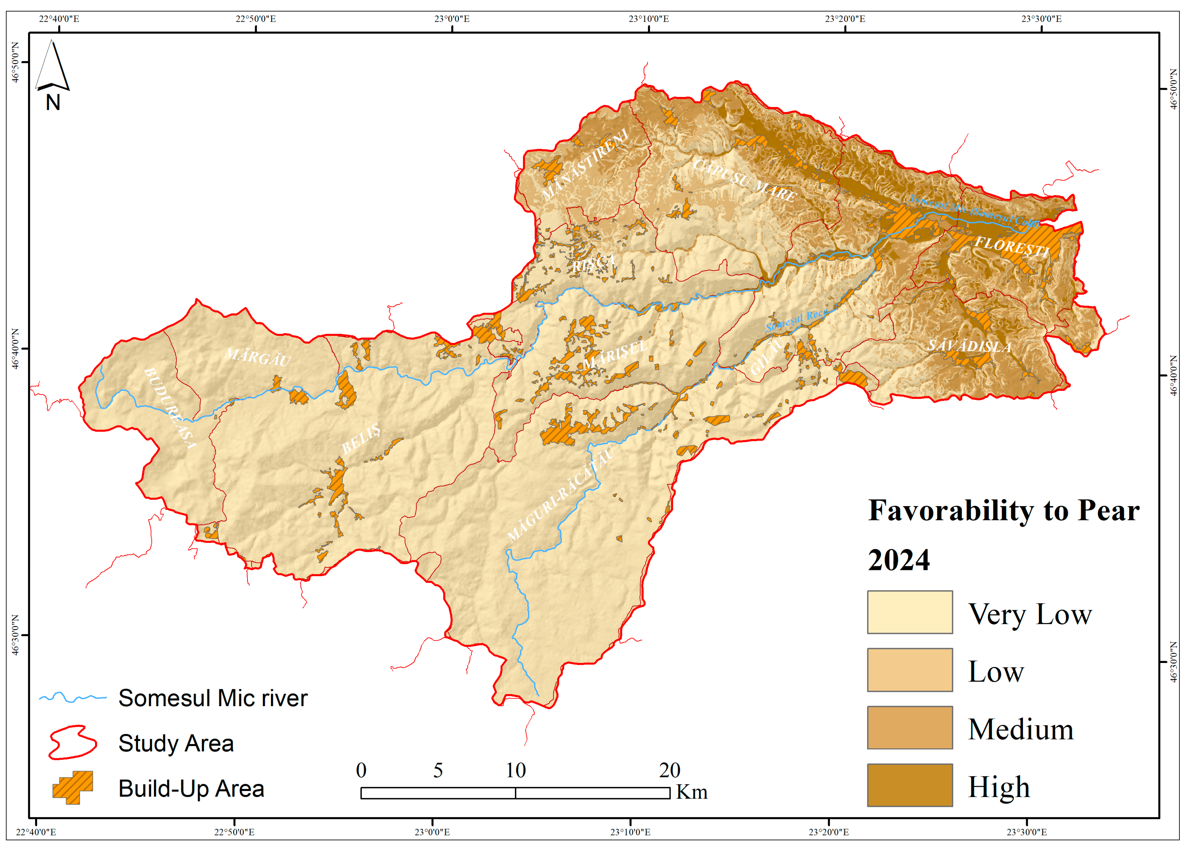
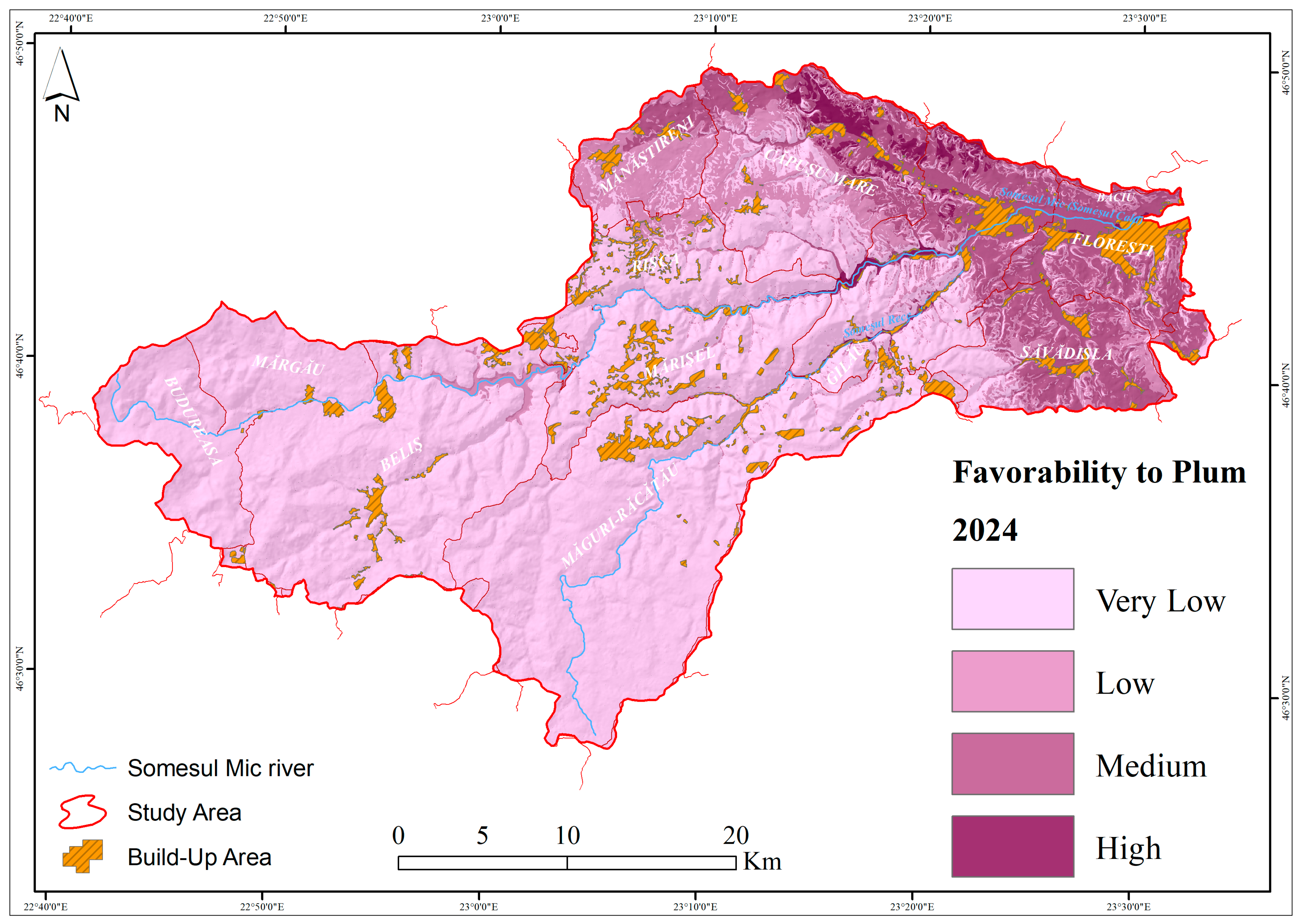
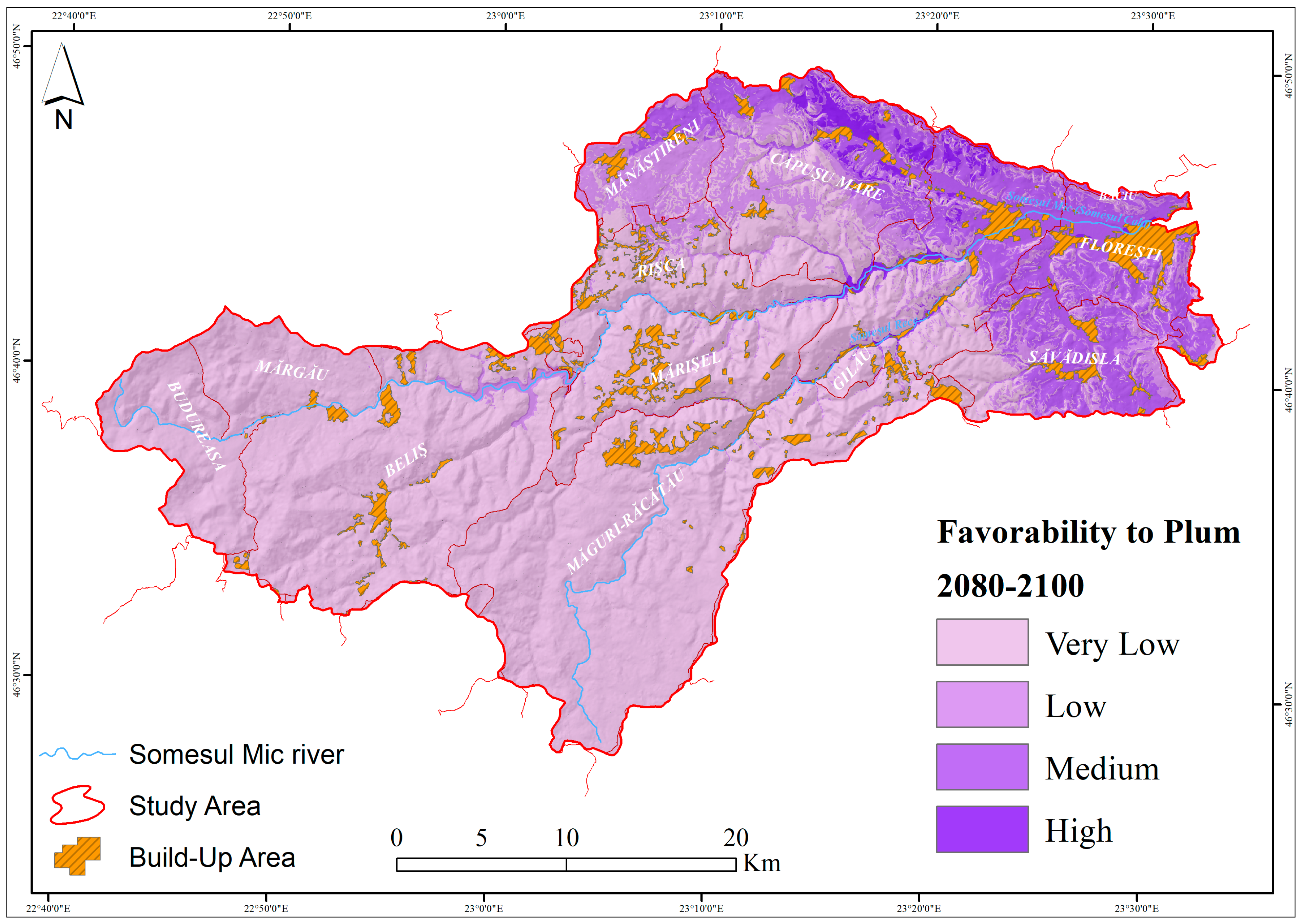
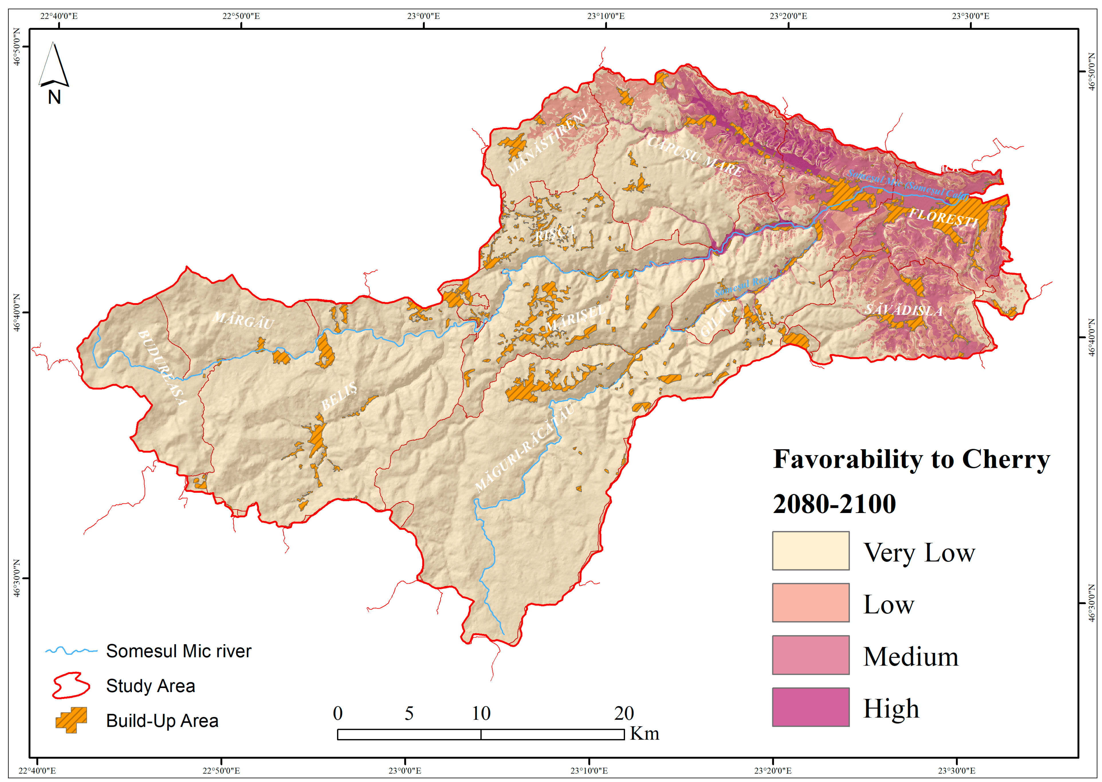
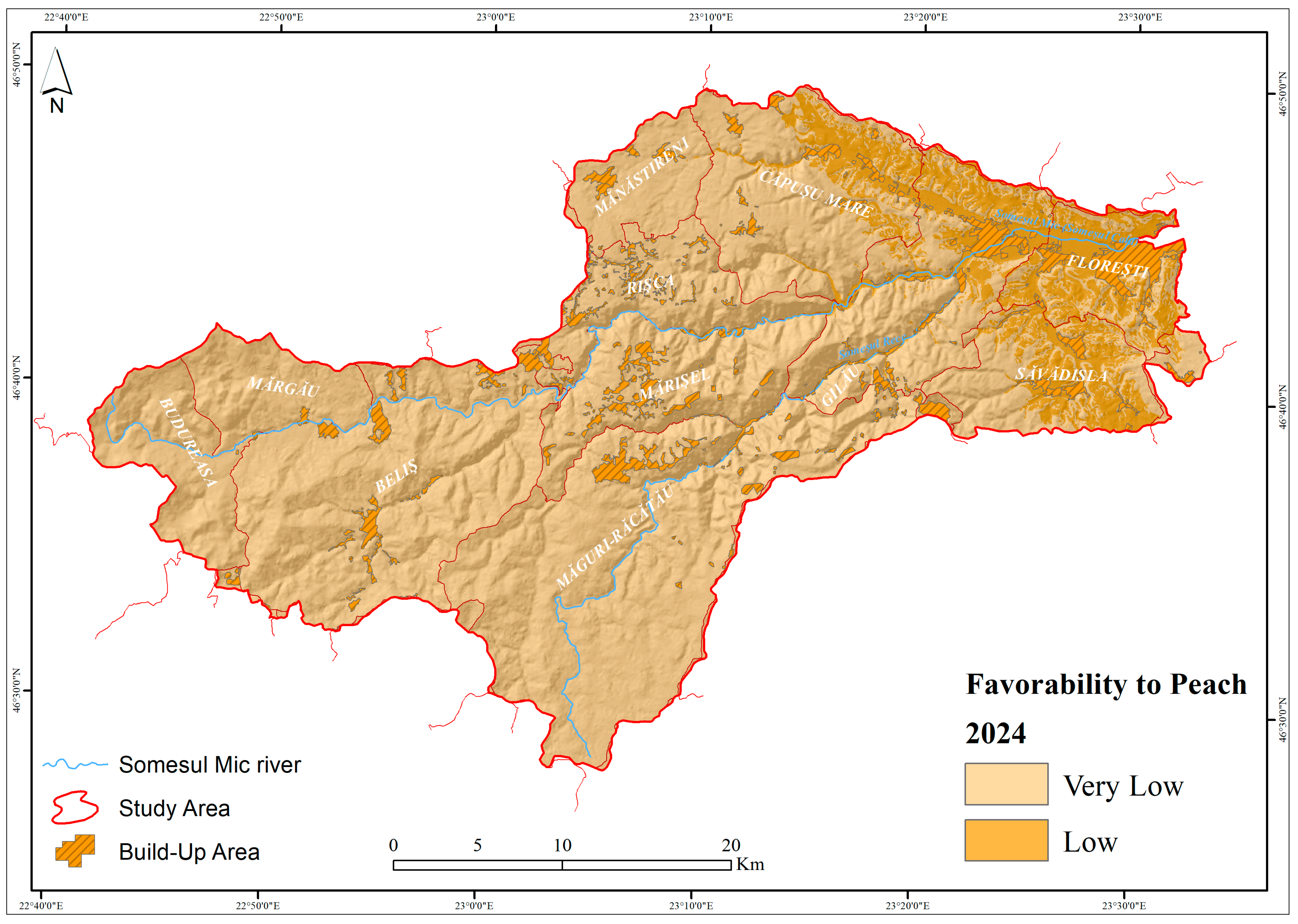
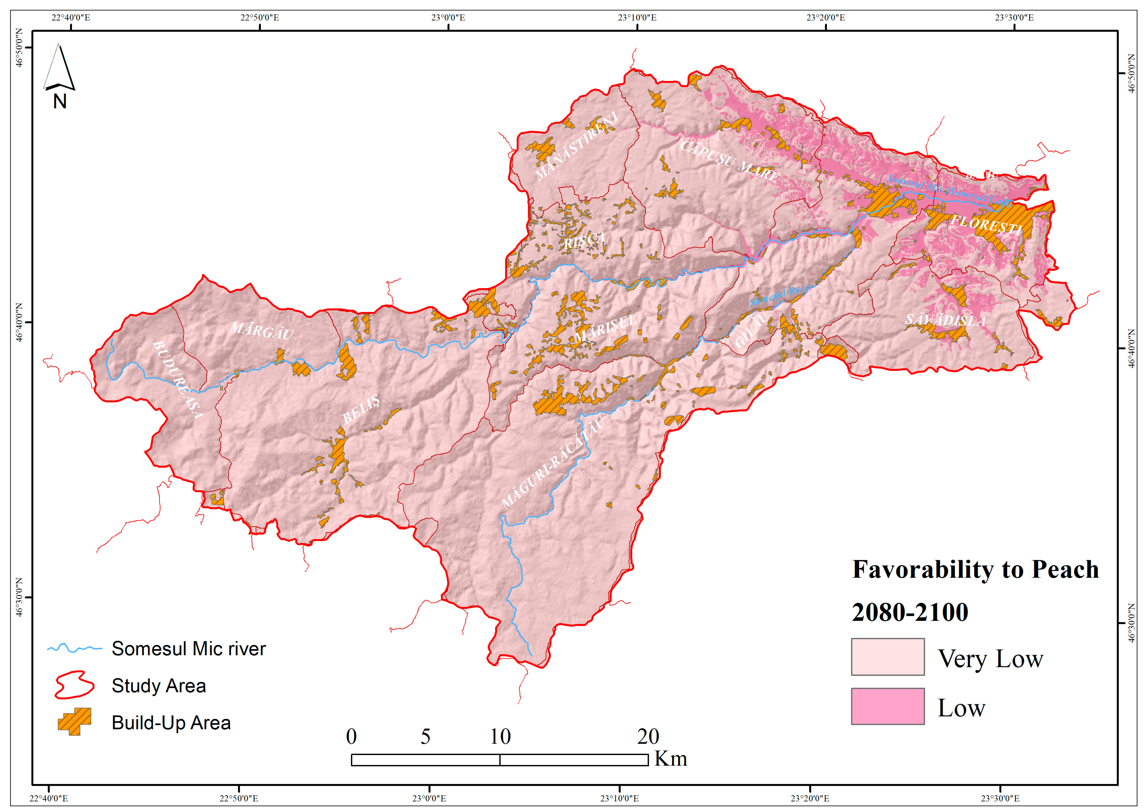
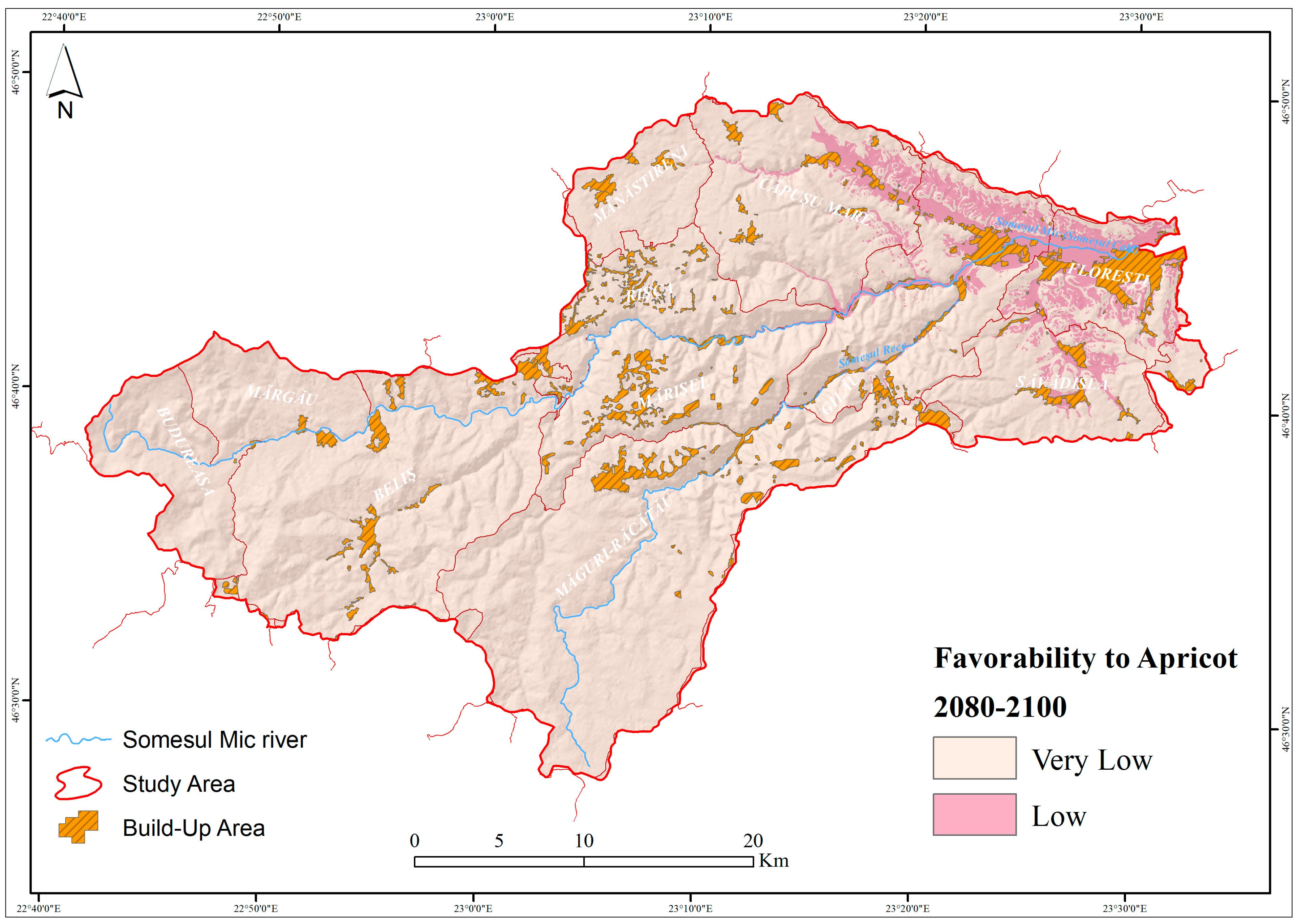
3. Results and Discussion

Principally, the conventional method of evaluating agricultural land suitability depends on the biophysical properties of the soil. This approach often adheres to two primary methodologies: qualitative and quantitative. Qualitative approaches classify land suitability into predetermined categories, such as “very highly suitable”, “moderately suitable”, or “not suitable”, according to diagnostic criteria [83]. By contrast, quantitative approaches involve mathematical formulae to calculate an index, therefore providing a more accurate assessment of land capacity [84]. Modern technologies combine expert knowledge, machine learning, and customized models to improve the ability to assess crop suitability in different scenarios with more precision and adaptability [85]. In our case, the results belong to the category of studies that use a quantitative model to categorize all land parcels into suitability classes, taking into account current and future conditions.
The implementation of the suggested model yields findings which allow the classification of the study’s area into distinct favorability categories for grassland, orchards, and pasture. For grassland use, the favorability value ranges from 2.1 to 100 (Figure 3). Favorability class IV (low) occupies nearly 42% of the study area, while the medium favorability class (III) occupies 20.54%, the high favorability class (II) occupies 11%, and the very high favorability class (I) occupies 14.77%. This supports an average favorability for this area considering the topography, soil, and climatic characteristics.
According to the results of the GIS model, the favorability for pasture ranges from 11.7 to 100, being classified according to the methodology into five favorability classes. The 11 administrative territorial units are covered with 30.65% favorability class III (medium), 25.65% favorability class II (high), and 20.36% favorability class (very high). This fact supports the favorable suitability of this use in the study area (Figure 4).
The use of fruit trees is obtained by arithmetic average of the maximum value of the six crops: apple, pear, plum, cherry, apricot, and peach s.a. This operation results in the above map showing the low to very low favorability of this use. The scores given to the use of fruit trees, as a result of the calculation, range from 0 to 50.1, which classifies the use of fruit trees into three favorability classes. Very poor favorability (class V) covers 82.48% of the study area, followed by poor favorability (class IV) with 14.78%, while medium favorability (class III) occupies 3%. This emphasizes that the study area is not suitable for orchard use (Figure 5).
The effective identification of suitable agro-ecological zones and the mitigation of climate change effects on land suitability are essential for improving crop yields and promoting the financial stability of small-scale farmers. By precisely identifying these zones, farmers can maximize resource utilization and adjust to evolving environmental conditions, resulting in healthier crop production [86,87].
A statistical analysis of the fit of the 6385 pasture, grassland, and orchard plots in the study area to the five favorability classes indicates a Receiver Operating Characteristic (ROC) curve value (which is a tool used to evaluate the performance of a model) of 0.823 for orchards, 0.708 for pastures, and 0.806 for grassland (Figure 6).
The results obtained from the application of the GIS model for the study area were validated using the ROC curve. The values obtained were 0.823 for orchards, 0.708 for pastures, and 0.806 for grasslands. These values indicate that there is an 83% chance that the model correctly identifies a favorable and unfavorable location for an orchard, a 70.8% chance for pastures, and an 80.6% chance for grasslands. This result signifies a robust model that is highly likely to be effective for making practical decisions in determining the favorability of land use using the provided GIS model [88].
The box plot graphs provide an overview of the distribution of favorability of land parcels across different favorability classes. From the data provided, we can deduce that the distribution has a slight tendency towards higher favorability classes for grassland use (mean > median), with the dispersion of plots being the highest for this land use type. In the case of favorability for orchards, the dispersion is the lowest, the mean being slightly higher than the median, indicating a slight presence of values above 1, but in general the data remain highly concentrated around class 1. The distribution is strongly asymmetric and does not show a large variation, suggesting that most of the land parcels are considered unfavorable for peach and apricot (due to the restrictiveness induced by the mean temperature values being too low in the study area than the species needs). This is supported by the low mean (1.32) and relatively low maximum (3) (Figure 7).
In order to achieve the second objective of the study, that is to identify the future favorability classes, the temperature and precipitation values from climate models for the time frames 2020–2040, 2040–2060, 2060–2080, and 2080–2100 were used, and the future favorability classes were assigned based on current conditions (Table 3).
The mean annual precipitation for the study area is currently 967 mm/year, but according to the climate scenarios, it can vary from 936.95 mm/year in the period 2020–2039, according to SSP1-2.6, to 821.94 mm/year in the period 2070–2099 mm/year, according to SSP5-8.5 [77] (Table 4).
The average temperature for the study area has a value for the present time of 5.51 °C; according to the climate scenarios, it can vary from 10.98 °C in the period 2070–2099, according to SSP1-1.9, to 15.40 °C in the period 2070–2099, according to SSP5-8.5 [41] (Table 5).
A statistical analysis of the classification of parcels for grassland use reveals significant variations by favorability class, both at present and in the medium and long term. In the long term, comparing the current situation with the climate projections for the period 2070–2099, a decrease in the high favorability of the land is observed. Under the SSP5-8.5 scenario, which anticipates an increase in average temperature to 15.4 °C and an annual precipitation of 821 mm, the areas in the high favorability class are projected to decrease by 4.7%. Similarly, under SSP3-7.0, which predicts an average temperature of 14.05 °C and annual precipitation of 844 mm, the estimated decrease is 4.4%. Under the SSP2-4.5 scenario, which projects an average temperature of 12.7 °C and annual precipitation of 895 mm, the reduction is more modest at 1.6%. These results underline the significant impact of climate change on the suitability of land for grassland use, indicating a progressive decrease in the areas optimal for grassland use under increasing temperatures and variations in the projected precipitation regime.
In the context of climate change, land use for grassland pasture will change significantly between 2020 and 2039 according to climate projections. The modeling based on the SSP1-2.6 scenario, which predicts an increase in precipitation to 936 mm and average temperature to 11 °C, indicates a reduction in the area in the very low favorability class by 23.3%. Similarly, under the SSP2-4.5 scenario, which predicts an average temperature of 12.75 °C and annual precipitation of 895 mm, the decrease in this category is 18.8%. At the same time, for the high and very high favorability classes, the SSP2-4.5 modeling shows an increase of 2.2%. These changes suggest a redistribution of favorable land for pasture use according to climatic developments, with the potential for improved grassland conditions in areas where the climate becomes more favorable at the expense of others. This study highlights the need to adapt land use strategies to new climatic conditions in order to optimize natural resource management in the context of projected climate change.
In the case of orchards, the analysis shows a fluctuating variation in land favorability in the context of climate change (Figure 8). According to the SSP1-1.9 scenario, in the immediate future, the areas in the very low favorability class are expected to decrease by 3.4%. This decrease is even more pronounced under the SSP2-4.5 scenario, where a reduction of up to 6.4% is projected, given an average temperature of 12.7 °C and an annual precipitation of 895 mm. The low favorability class also shows a decrease of 5.1%. In contrast, for the high and very high favorability classes, there is a slight increase of up to 0.7% in the areas falling into these categories.
This increase in favorability is particularly relevant in the context of the expected increase in temperature, given that the favorability assessment for orchards is made by averaging the favorability for species such as apple, pear, plum, and cherry (Figure 9, Figure 10, Figure 11, Figure 12, Figure 13, Figure 14, Figure 15, Figure 16, Figure 17, Figure 18, Figure 19 and Figure 20). In particular, for the cherry, peach, and apricot species, which require higher temperature limits for optimal development and acceptable yields, the increase in the multiannual mean temperature has a beneficial impact. Thus, some plots that were previously classified in the high favorability class could move to the very high favorability class. This qualitative leap will also be reflected in the statistical analysis of the suitability of plots for orchard use, underlining the importance of adapting orchard management strategies to the new climatic conditions forecast.
Considering the above variables, landowners with existing fruit tree orchards might strategically choose to cultivate new species and types based on the expected future conditions in the medium term.
Anthropogenic activities are exerting a growing impact on land resources in the context of climate change, consequently increasing ecosystem degradation and reducing land productivity. Various anthropogenic activities, including deforestation, urban growth, and unsustainable agricultural methods, are responsible for soil erosion [89], the loss of biodiversity, and the depletion of nutrients. Furthermore, climate change increases these effects by imposing extra pressure on already delicate land systems through changes in temperature and precipitation patterns. The combined impact of human pressures and climate unpredictability reduces the adaptive capacity of land resources, therefore presenting substantial threats to the long-term viability of agriculture and the availability of food. The resolution of these issues requires the implementation of comprehensive land management approaches that tackle both human-induced and climate-related elements.
The population density fluctuations in the study area make it difficult to model due to the lengthy duration of the modeling and the reliance on climate scenarios. However, there has been a general trend in the study area throughout the past period of population migration from neighboring urban areas (Cluj Napoca, Huedin, Turda) to this territory [90]. This migration is driven by the attractive landscape, rich soil resources, and high tourism potential of the mountainous area in the upper basin of the Somesului Mic, as indicated by the increase in the number of buildings that have appeared, especially after the COVID-19 pandemic.
The main goals in land use planning and policy development in relation to climate change involve the promotion of climate-smart agricultural practices that improve food security, reduce environmental consequences, and protect farmland against climate-related issues such as acidification of the soil. In addition, successful land use planning should include collaboration across local, regional, and national stakeholders to provide an integrated governance framework that promotes active participation and responsibility in climate adaptation initiatives. Moreover, it is important to prioritize biodiversity conservation by implementing policies that seek to preserve natural ecosystems, encourage reforestation, and include biodiversity protection in both urban and rural development systems.

4. Conclusions

The present case study aims to improve the overall comprehension of how Geographic Information System (GIS) capabilities can be utilized to facilitate sustainable land management in mountainous areas that are confronted with the combined challenges of climate change and development. The findings of this study will provide important information for land use planners, environmental managers, and policy makers operating in the Apuseni Mountains (the Somesul Mic watershed) and similar areas.
Having knowledge regarding the interaction between climate factors and human activities is essential for predicting future changes in land use and effectively monitoring landscapes in a sustainable manner. The ongoing evolution of climate change and human activities will have a progressively major impact on land usage, creating issues for environmental conservation and resource management.
The results reveal significant shifts in land use favorability patterns under future climate scenarios, with certain areas becoming more suitable for agriculture, while others may face increased risks of land degradation or reduced agricultural potential. This GIS-based approach offers valuable insights for regional planning and sustainable land management, helping stakeholders adapt to changing environmental conditions. The findings underscore the need for proactive strategies to mitigate climate change impacts on land use and support the resilience of the Apuseni Mountains’ ecosystems and communities.
This study incorporates a quantitative Geographic Information System (GIS) model to evaluate the suitability of land for important agricultural purposes, such as grasslands, pastures, and orchards. The assessment is based on environmental criteria, including soil properties, climatic variables, and topographic characteristics. An analysis of SSP climate scenarios (SSP1-1.9, SSP1-2.6, SSP2-4.5, SSP3-7.0, and SSP5-8.5) from 2020 to 2099 shows variations in land suitability, with decreases in high favorability for pastures and grasslands and a little increase in favorability for orchards under specific circumstances. The GIS classification of land favorability offers a reliable and data-driven approach to assess current suitability and predict future changes, essential for well-informed land management and agricultural planning.
While GIS-based land suitability models offer meaningful insights into agricultural potential in the context of climate change scenarios, they are subject to several limitations. The presence of uncertainty in the climate projections might lead to diverse results, therefore introducing complexity to the dependability of the forecasts. In addition, the reliance on existing spatial data, which may be lacking in completeness or generalization, restricts the accuracy of the model, especially at small scales. The models often failed to consider intricate interactions between natural forces and socio-economic variables that are essential for making land use decisions. Moreover, the level of detail in GIS data may not consistently include slight variations at a small scale, therefore diminishing the success of the models in directing specific agricultural adaptation measures.
The potential future research will integrate Geographic Information Systems (GISs) with computer-based machine learning algorithms to improve land suitability evaluations in the context of climate change scenarios. The integration of Geographic Information Systems (GISs) with machine learning facilitates the generation of more advanced and data-oriented insights, therefore enabling the real-time monitoring of land use and climatic effects.
The results of this study have substantial consequences for practical implementations. The capacity to forecast the anticipated changes in land suitability under various climatic scenarios enables policy makers, farmers, and local authorities to actively adjust their policies regarding agriculture. For instance, comprehending the changing suitability of land for different crops helps guide choices for crop rotation, diversity, and resource distribution, thus enhancing agricultural resilience. Moreover, the emphasis of this publication on the financial consequences of climate change, notably in areas heavily reliant on agriculture, underscores the wider implications of decreased agricultural output, including market instability and the inflation in food prices. This research provides a comprehensive assessment of future agricultural viability, which in turn facilitates the formulation of adaptive measures aimed at reducing the economic vulnerabilities associated with climate change. Within this particular framework, the incorporation of GIS modeling and climatic scenarios offers vital instruments for the purpose of sustainable land use planning, therefore guaranteeing the continued viability of agriculture despite the present environmental and economic obstacles.

Author Contributions

Conceptualization G.S., S.R., I.P. and Ș.B.; methodology Ș.B., I.P., S.R., H.M. and I.F.; software H.M., S.R. and I.F.; validation C.N., L.V.B. and F.F.; formal analysis F.F., C.N. and L.V.B.; investigation S.R., G.S. and H.M.; resources H.M., I.P., Ș.B. and I.F.; data curation: G.S., H.M. and S.R; writing—original draft preparation S.R., G.S. and H.M; writing—review and editing S.R., F.F. and G.S.; visualization H.M., S.R. and Ș.B.; All authors have contributed equally to the work. All authors have read and agreed to the published version of the manuscript.

Funding

This research received no external funding.

Institutional Review Board Statement

Not applicable.

Informed Consent Statement

Not applicable.

Data Availability Statement

The original contributions presented in the study are included in the article, further inquiries can be directed to the corresponding author.

Conflicts of Interest

The authors declare no conflicts of interest.

References

  1. Kalnay, E.; Cai, M. Impact of urbanization and land-use change on climate. Nature 2003, 423, 528–531. [Google Scholar] [PubMed]
  2. Foley, J.A.; Defries, R.; Asner, G.P.; Barford, C.; Bonan, G.; Carpenter, S.R.; Chapin, F.S.; Coe, M.T.; Daily, G.C.; Gibbs, H.K.; et al. Global consequences of land use. Science 2005, 309, 570–574. [Google Scholar]
  3. Yahaya, I.; Xu, R.; Zhou, J.; Jiang, S.; Su, B.; Huang, J.; Cheng, J.; Dong, Z.; Jiang, T. Projected patterns of land uses in Africa under a warming climate. Sci. Rep. 2024, 14, 12315. [Google Scholar] [CrossRef]
  4. Patriche, C.V.; Irimia, L.M. Mapping the impact of recent climate change on viticultural potential in Romania. Theor. Appl. Climatol. 2022, 148, 1035–1056. [Google Scholar]
  5. Prăvălie, R.; Peptenatu, D.; Sirodoev, I. The impact of climate change on the dynamics of agricultural systems in south-western Romania. Carpathian J. Earth Environ. Sci. 2013, 8, 175–186. [Google Scholar]
  6. Prăvălie, R.; Sîrodoev, I.; Nita, I.A.; Patriche, C.; Dumitraşcu, M.; Roşca, B.; Tişcovschi, A.; Bandoc, G.; Săvulescu, I.; Mănoiu, V.; et al. NDVI-based ecological dynamics of forest vegetation and its relationship to climate change in Romania during 1987–2018. Ecol. Indic. 2022, 136, 108629. [Google Scholar]
  7. Adams, R.M.; Hurd, B.H.; Lenhart, S.; Leary, N. Effects of global climate change on agriculture: An interpretative review. Clim. Res. 1998, 11, 19–30. [Google Scholar]
  8. Howden, S.M.; Soussana, J.F.; Tubiello, F.N.; Chhetri, N.; Dunlop, M.; Meinke, H. Adapting agriculture to climate change. Proc. Natl. Acad. Sci. USA 2007, 104, 19691–19696. [Google Scholar] [PubMed]
  9. Malhi, G.S.; Kaur, M.; Kaushik, P. Impact of climate change on agriculture and its mitigation strategies: A review. Sustainability 2021, 13, 1318. [Google Scholar] [CrossRef]
  10. Agovino, M.; Casaccia, M.; Ciommi, M.; Ferrara, M.; Marchesano, K. Agriculture, climate change and sustainability: The case of EU-28. Ecol. Indic. 2019, 105, 525–543. [Google Scholar]
  11. Zoran, M.A.; Zoran, L.F.V.; Dida, A.I. Forest vegetation dynamics and its response to climate changes. In Remote Sensing for Agriculture, Ecosystems, and Hydrology XVIII; SPIE: St Bellingham, WA, USA, 2016; Volume 9998, pp. 598–608. [Google Scholar]
  12. Mihai, G.; Alexandru, A.M.; Nita, I.A.; Birsan, M.V. Climate change in the provenance regions of Romania over the last 70 years: Implications for forest management. Forests 2022, 13, 1203. [Google Scholar] [CrossRef]
  13. Stringer, L.C.; Scrieciu, S.S.; Reed, M.S. Biodiversity, land degradation, and climate change: Participatory planning in Romania. Appl. Geogr. 2009, 29, 77–90. [Google Scholar]
  14. Rusu, T.; Moraru, P.I.; Coste, C.; Cacovean, H.; Chețan, F.; Chețan, C. Impact of climate change on climatic indicators in Transylvanian Plain, Romania. J. Food Agric. Environ. 2014, 12, 469–473. [Google Scholar]
  15. Li, C.; de Jong, R.; Schmid, B.; Wulf, H.; Schaepman, M.E. Spatial variation of human infuences on grassland biomass on the Qinghai-Tibetan plateau. Sci. Total Environ. 2019, 665, 678–689. [Google Scholar]
  16. Rusu, T.; Moraru, P.I. Impact of climate change on crop land and technological recommendations for the main crops in Transylvanian Plain, Romania. Rom. Agric. Res. 2015, 32, 103–111. [Google Scholar]
  17. Cheval, S.; Dumitrescu, A.; Adamescu, M.; Cazacu, C. Identifying climate change hotspots relevant for ecosystems in Romania. Clim. Res. 2020, 80, 165–173. [Google Scholar]
  18. Hurtt, G.C.; Chini, L.; Sahajpal, R.; Frolking, S.; Bodirsky, B.L.; Calvin, K.; Doelman, J.C.; Fisk, J.; Fujimori, S.; Goldewijk, K.K.; et al. Harmonization of global land use change and management for the period 850–2100 (LUH2) for CMIP6. Geosci. Model Dev. 2020, 13, 5425–5464. [Google Scholar]
  19. Cheval, S.; Bulai, A.; Croitoru, A.E.; Dorondel, Ș.; Micu, D.; Mihăilă, D.; Sfîcă, L.; Tișcovschi, A. Climate change perception in Romania. Theor. Appl. Climatol. 2022, 149, 253–272. [Google Scholar] [PubMed]
  20. Necula, C.; Rossing, W.A.; Easdale, M.H. Archetypes of climate change adaptation among large-scale arable farmers in southern Romania. Agron. Sustain. Dev. 2024, 44, 1–18. [Google Scholar]
  21. Mahmood, R.; Pielke, R.A.; Hubbard, K.G.; Niyogi, D.; Bonan, G.; Lawrence, P.; McNider, R.; McAlpine, C.; Etter, A.; Gameda, S.; et al. Impacts of land use/land cover change on climate and future research priorities. Bull. Am. Meteorol. Soc. 2010, 91, 37–46. [Google Scholar]
  22. Prăvălie, R.; Sîrodoev, I.; Patriche, C.; Roșca, B.; Piticar, A.; Bandoc, G.; Sfîcă, L.; Tişcovschi, A.; Dumitraşcu, M.; Chifiriuc, C.; et al. The impact of climate change on agricultural productivity in Romania. A country-scale assessment based on the relationship between climatic water balance and maize yields in recent decades. Agric. Syst. 2020, 179, 102767. [Google Scholar]
  23. Gunderson, C.A.; O’hara, K.H.; Campion, C.M.; Walker, A.V.; Edwards, N.T. Thermal plasticity of photosynthesis: The role of acclimation in forest responses to a warming climate. Glob. Chang. Biol. 2010, 16, 2272–2286. [Google Scholar]
  24. Tkemaladze, G.S.; Makhashvili, K.A. Climate changes and photosynthesis. Ann. Agrar. Sci. 2016, 14, 119–126. [Google Scholar]
  25. Reich, P.B.; Sendall, K.M.; Stefanski, A.; Rich, R.L.; Hobbie, S.E.; Montgomery, R.A. Effects of climate warming on photosynthesis in boreal tree species depend on soil moisture. Nature 2018, 562, 263–267. [Google Scholar]
  26. Haokip, S.W.; Shankar, K.; Lalrinngheta, J. Climate change and its impact on fruit crops. J. Pharmacogn. Phytochem. 2020, 9, 435–438. [Google Scholar]
  27. Deryng, D.; Conway, D.; Ramankutty, N.; Price, J.; Warren, R. Global crop yield response to extreme heat stress under multiple climate change futures. Environ. Res. Lett. 2014, 9, 034011. [Google Scholar]
  28. Sun, Q.; Miao, C.; Hanel, M.; Borthwick, A.G.; Duan, Q.; Ji, D.; Li, H. Global heat stress on health, wildfires, and agricultural crops under different levels of climate warming. Environ. Int. 2019, 128, 125–136. [Google Scholar]
  29. Zhao, C.; Piao, S.; Wang, X.; Huang, Y.; Ciais, P.; Elliott, J.; Huang, M.; Janssens, I.A.; Li, T.; Lian, X.; et al. Plausible rice yield losses under future climate warming. Nat. Plants 2016, 3, 16202. [Google Scholar]
  30. Benlloch-González, M.; Sánchez-Lucas, R.; Bejaoui, M.A.; Benlloch, M.; Fernández-Escobar, R. Global warming effects on yield and fruit maturation of olive trees growing under field conditions. Sci. Hortic. 2019, 249, 162–167. [Google Scholar]
  31. Kaiser, H.M.; Riha, S.J.; Wilks, D.S.; Rossiter, D.G.; Sampath, R. A farm-level analysis of economic and agronomic impacts of gradual climate warming. Am. J. Agric. Econ. 1993, 75, 387–398. [Google Scholar]
  32. Toromade, A.S.; Soyombo, D.A.; Kupa, E.; Ijomah, T.I. Reviewing the impact of climate change on global food security: Challenges and solutions. Int. J. Appl. Res. Soc. Sci. 2024, 6, 1403–1416. [Google Scholar]
  33. Shaver, G.R.; Canadell, J.; Chapin, F.S.; Gurevitch, J.; Harte, J.; Henry, G.; Ineson, P.; Jonasson, S.; Melillo, J.; Pitelka, L.; et al. Global Warming and Terrestrial Ecosystems: A Conceptual Framework for Analysis: Ecosystem responses to global warming will be complex and varied. Ecosystem warming experiments hold great potential for providing insights on ways terrestrial ecosystems will respond to upcoming decades of climate change. Documentation of initial conditions provides the context for understanding and predicting ecosystem responses. Bioscience 2000, 50, 871–882. [Google Scholar]
  34. Magyari-Sáska, Z.; Magyari-Sáska, A. Changes and Trends in Ideal Holiday Period Based On Holiday Climate Index Applied To The Carpathian Basin. Geogr. Tech. 2023, 18, 225–237. [Google Scholar]
  35. Traill, L.W.; Lim, M.L.; Sodhi, N.S.; Bradshaw, C.J. Mechanisms driving change: Altered species interactions and ecosystem function through global warming. J. Anim. Ecol. 2010, 79, 937–947. [Google Scholar]
  36. Saxe, H.; Cannell, M.G.; Johnsen, Ø.; Ryan, M.G.; Vourlitis, G. Tree and forest functioning in response to global warming. New Phytol. 2001, 149, 369–399. [Google Scholar]
  37. Haarsma, R.J.; Hazeleger, W.; Severijns, C.; de Vries, H.; Sterl, A.; Bintanja, R.; Jan van Oldenborgh, G.; van den Brink, H.W. More hurricanes to hit western Europe due to global warming. Geophys. Res. Lett. 2013, 40, 1783–1788. [Google Scholar]
  38. Vautard, R.; Gobiet, A.; Sobolowski, S.; Kjellström, E.; Stegehuis, A.; Watkiss, P.; Mendlik, T.; Landgren, O.; Nikulin, G.; Teichmann, C.; et al. The European climate under a 2 C global warming. Environ. Res. Lett. 2014, 9, 034006. [Google Scholar]
  39. Lehmann, J.; Coumou, D.; Frieler, K. Increased record-breaking precipitation events under global warming. Clim. Chang. 2015, 132, 501–515. [Google Scholar]
  40. Roudier, P.; Andersson, J.; Donnelly, C.; Feyen, L.; Greuell, W.; Ludwig, F. Projections of future floods and hydrological droughts in Europe under a+ 2 C global warming. Clim. Chang. 2016, 135, 341–355. [Google Scholar]
  41. Magyari-Sáska, Z.; Croitoru, A.E.; Horváth, C.; Dombay, Ș. ClimShift–A new toolbox for the detection of climate change. Geosci. Data J. 2023, in press. [Google Scholar] [CrossRef]
  42. Piticar, A.; Andrei, S.; Tudor, A. Spatiotemporal Variability of Convective Events in Romania Based on METAR Data. Sustainability 2024, 16, 3243. [Google Scholar] [CrossRef]
  43. Uber, M.; Haller, M.; Brendel, C.; Hillebrand, G.; Hoffmann, T. Past, present and future rainfall erosivity in central Europe based on convection-permitting climate simulations. Hydrol. Earth Syst. Sci. 2024, 28, 87–102. [Google Scholar]
  44. Ochoa, C.; Bar-Massada, A.; Chuvieco, E. A European-scale analysis reveals the complex roles of anthropogenic and climatic factors in driving the initiation of large wildfires. Sci. Total Environ. 2024, 917, 170443. [Google Scholar] [PubMed]
  45. Bratu, I.A.; Câmpu, V.R.; Budău, R.; Stanciu, M.A.; Enescu, C.M. Subsidies for Forest Environment and Climate: A Viable Solution for Forest Conservation in Romania? Forests 2024, 15, 1533. [Google Scholar] [CrossRef]
  46. Tudoran, G.M. Composition of Natural Forest Types—Long-Term Goals for Sustainable Forest Management. Forests 2024, 15, 1196. [Google Scholar] [CrossRef]
  47. Felton, A.; Belyazid, S.; Eggers, J.; Nordström, E.M.; Öhman, K. Climate change adaptation and mitigation strategies for production forests: Trade-offs, synergies, and uncertainties in biodiversity and ecosystem services delivery in Northern Europe. Ambio 2024, 53, 1–16. [Google Scholar]
  48. Ignjačević, P.; Botzen, W.; Estrada, F.; Daanen, H.; Lupi, V. Climate-induced mortality projections in Europe: Estimation and valuation of heat-related deaths. Int. J. Disaster Risk Reduct. 2024, 111, 104692. [Google Scholar]
  49. Urban, M.C.; Swaegers, J.; Stoks, R.; Snook, R.R.; Otto, S.P.; Noble, D.W.A.; Moiron, M.; Hällfors, M.H.; Gómez-Llano, M.; Fior, S.; et al. When and how can we predict adaptive responses to climate change? Evol. Lett. 2024, 8, 172–187. [Google Scholar]
  50. Pearman, P.B.; Broennimann, O.; Aavik, T.; Albayrak, T.; Alves, P.C.; Aravanopoulos, F.A.; Bertola, L.D.; Biedrzycka, A.; Buzan, E.; Cubric-Curik, V.; et al. Monitoring of species’ genetic diversity in Europe varies greatly and overlooks potential climate change impacts. Nat. Ecol. Evol. 2024, 8, 267–281. [Google Scholar]
  51. Viñals, E.; Maneja, R.; Rufí-Salís, M.; Martí, M.; Puy, N. Reviewing social-ecological resilience for agroforestry systems under climate change conditions. Sci. Total Environ. 2023, 869, 161763. [Google Scholar]
  52. Benitez-Alfonso, Y.; Soanes, B.K.; Zimba, S.; Sinanaj, B.; German, L.; Sharma, V.; Bohra, A.; Kolesnikova, A.; Dunn, J.A.; Martin, A.C.; et al. Enhancing climate change resilience in agricultural crops. Curr. Biol. 2023, 33, R1246–R1261. [Google Scholar] [PubMed]
  53. Lin, B.B. Resilience in agriculture through crop diversification: Adaptive management for environmental change. BioScience 2011, 61, 183–193. [Google Scholar]
  54. Qiao, L.; Wang, X.; Smith, P.; Fan, J.; Lu, Y.; Emmett, B.; Li, R.; Dorling, S.; Chen, H.; Liu, S.; et al. Soil quality both increases crop production and improves resilience to climate change. Nat. Clim. Change 2022, 12, 574–580. [Google Scholar]
  55. IPCC. Climate Change 2022: Impacts, Adaptation, and Vulnerability. In Contribution of Working Group II to the Sixth Assessment Report of the Intergovernmental Panel on Climate Change; Cambridge University Press: Cambridge, UK, 2022. [Google Scholar]
  56. Bielecka, E. GIS spatial analysis modeling for land use change. A bibliometric analysis of the intellectual base and trends. Geosciences 2020, 10, 421. [Google Scholar] [CrossRef]
  57. Romano, G.; Dal Sasso, P.; Trisorio Liuzzi, G.; Gentile, F. Multi-Criteria Decision Analysis for Land Suitability Mapping in a Rural Area of Southern Italy. Land Use Policy 2015, 48, 131–143. [Google Scholar]
  58. Montgomery, B.; Dragićević, S. Comparison of GIS-Based Logic Scoring of Preference and Multicriteria Evaluation Methods: Urban Land Use Suitability. Geogr. Anal. 2016, 48, 427–447. [Google Scholar]
  59. Prăvălie, R.; Niculiţă, M.; Roşca, B.; Patriche, C.; Dumitraşcu, M.; Marin, G.; Nita, I.-A.; Bandoc, G. Modelling forest biomass dynamics in relation to climate change in Romania using complex data and machine learning algorithms. Stoch. Environ. Res. Risk Assess. 2023, 37, 1669–1695. [Google Scholar]
  60. Irimia, L.M.; Patriche, C.V.; Quenol, H.; Sfîcă, L.; Foss, C. Shifts in climate suitability for wine production as a result of climate change in a temperate climate wine region of Romania. Theor. Appl. Climatol. 2018, 131, 1069–1081. [Google Scholar]
  61. Brandolini, F.; Compostella, C.; Pelfini, M.; Turner, S. The Evolution of Historic Agroforestry Landscape in the Northern Apennines (Italy) and Its Consequences for Slope Geomorphic Processes. Land 2023, 12, 1054. [Google Scholar] [CrossRef]
  62. Fathian, F.; Prasad, A.D.; Dehghan, Z.; Eslamian, S. Influence of land use/land cover change on land surface temperature using RS and GIS techniques. Int. J. Hydrol. Sci. Technol. 2015, 5, 195–207. [Google Scholar]
  63. Galacho-Jiménez, F.B.; Quesada-Molina, P.; Carruana-Herrera, D.; Reyes-Corredera, S. Application of the Analysis Time Series and Multispectral Images for the Estimation of the Conditions of the Vegetation Covers of the Natural Areas of Southern Spain. Land. 2023, 12, 42. [Google Scholar] [CrossRef]
  64. Roșca, S.M.; Bilaşco, S.; Păcurar, I.; Marcel Oncu Negruşier, C.; Petrea, D. Land capability classification for crop and fruit product assessment using GIS technology. Case study: The Niraj River Basin (Transylvania Depression, Romania). Not. Bot. Horti Agrobot. Cluj-Napoca 2015, 43, 235–242. [Google Scholar]
  65. Zhao, L.Q.; van Duynhoven, A.; Dragićević, S. Machine Learning for Criteria Weighting in GIS-Based Multi-Criteria Evaluation: A Case Study of Urban Suitability Analysis. Land 2024, 13, 1288. [Google Scholar] [CrossRef]
  66. Bilaşco, Ş.; Roşca, S.; Păcurar, I.; Moldovan, N.; Amalia, B.O.Ţ.; Negrușier, C.; Sestras, P.; Bondrea, M.; Sanda, N.A.Ș. Identification of land suitability for agricultural use by applying morphometric and risk parameters based on GIS spatial analysis. Not. Bot. Horti Agrobot. Cluj-Napoca 2016, 44, 302–312. [Google Scholar]
  67. Ioan, M. Evaluation of Suitability for Different Agricultural Crops Based on Soil Improvement with an Emphasis on the Influence of Soil Pollution in the Someșului Mic Area, Cluj-Napoca—Dej Sector. Ph.D. Thesis, USAMV Cluj Napoca, Cluj-Napoca, Romania, 2021. [Google Scholar]
  68. Nath, I.B.; Ramey, V.A.; Klenow, P.J. How much Will Global Warming Cool Global Growth? (No. w32761); National Bureau of Economic Research: Cambridge, MA, USA, 2024. [Google Scholar]
  69. Folini, D.; Friedl, A.; Kübler, F.; Scheidegger, S. The climate in climate economics. Rev. Econ. Stud. 2024, rdae011. [Google Scholar] [CrossRef]
  70. Sarathamani, T.; Leelavathi, B. A Comprehensive Guide to Economic and Environmental Impact of Global Ice Warming and the Role of Artificial Intelligence in Fighting Climate Change. Educ. Adm. Theory Pract. 2024, 30, 879–886. [Google Scholar]
  71. Junaid, M.D.; Gokce, A.F. Global agricultural losses and their causes. Bull. Biol. Allied Sci. Res. 2024, 2024, 66. [Google Scholar]
  72. Soil Map of Romania, 1:200000; ICPA Bucharest: Bucharest, Romania, 2017.
  73. European Union—European Environment Agency (EEA). CLC 2012—Copernicus Land Monitoring Service. Corine Land Cover (CLC). 2012. Available online: https://land.copernicus.eu/pan-european/corine-land-cover/clc-2012/view (accessed on 3 February 2024).
  74. Hansen, M.C.; Potapov, P.V.; Moore, R.; Hancher, M.; Turubanova, S.A.; Tyukavina, A.; Thau, D.; Stehman, S.V.; Goetz, S.J.; Loveland, T.R.; et al. High-resolution global maps of 21st-century forest cover change. Science 2013, 342, 850–853. [Google Scholar]
  75. European Settlement Map. ESM 2012—Release 2016. Copernicus Land Monitoring Service. 2016. Available online: https://land.copernicus.eu/pan-european/GHSL/european-settlement-map/EU%20GHSL%202014?tab=metadata (accessed on 18 March 2024).
  76. OSM. Open Street Map. Geofabrik Download Server. 2017. Available online: https://download.geofabrik.de/ (accessed on 1 April 2024).
  77. The Climate Change Knowledge Portal (CCKP). Available online: https://climateknowledgeportal.worldbank.org (accessed on 4 June 2024).
  78. Clavero, M.; Villero, D.; Brotons, L. Climate change or land use dynamics: Do we know what climate change indicators indicate? PLoS ONE 2011, 6, e18581. [Google Scholar]
  79. Order 212/2002 Technical Norms. Part I Credit Rating of Agricultural Lands and Their Classification into Quality Classes. Available online: https://lege5.ro/Gratuit/gqytamru/partea-i-bonitarea-terenurilor-agricole-si-incadrarea-in-clase-de-calitate-a-acestora-norma-tehnica?dp=gizdknbwgyzdq (accessed on 2 March 2024).
  80. Păcurar, I.; Mihai, B. Pedology and the Certification of Agricultural Lands; Risoprint Publishing House: Cluj Napoca, Romania, 2015. [Google Scholar]
  81. Rosca, S. Bazinul Nirajului studiu de Geomorfologie aplicata; Risoprint Editorial House: Berlin, Germany, 2015. [Google Scholar]
  82. Matei, I.; Pacurar, I.; Rosca, S.; Bilasco, S.; Sestras, P.; Rusu, T.; Jude, E.T.; Tăut, F.D. Land Use Favourability Assessment Based on Soil Characteristics and Anthropic Pollution. Case Study Somesul Mic Valley Corridor, Romania. Agronomy 2020, 10, 1245. [Google Scholar] [CrossRef]
  83. Akpoti, K.; Kabo-bah, A.T.; Zwart, S.J. Agricultural land suitability analysis: State-of-the-art and outlooks for integration of climate change analysis. Agric. Syst. 2019, 173, 172–208. [Google Scholar]
  84. Bagherzadeh, A.; Ghadiri, E.; Souhani Darban, A.R.; Gholizadeh, A. Land suitability modeling by parametric-based neural networks and fuzzy methods for soybean production in a semi-arid region. Model. Earth Syst. Environ. 2016, 2, 104. [Google Scholar]
  85. Bonfante, A.; Langella, G.; Mercogliano, P.; Bucchignani, E.; Manna, P.; Terribile, F. Science of the Total Environment A dynamic viticultural zoning to explore the resilience of terroir concept under climate change. Sci. Total Environ. 2018, 624, 294–308. [Google Scholar] [CrossRef] [PubMed]
  86. Liambila, R.N.; Kibret, K. Climate change impact on land suitability for rainfed crop production in Lake Haramaya Watershed, Eastern Ethiopia. J. Earth Sci. Clim. Chang. 2016, 7, 1–12. [Google Scholar]
  87. Ranjitkar, S.; Sujakhu, N.M.; Merz, J.; Kindt, R.; Xu, J.; Matin, M.A.; Ali, M.; Zomer, R.J. Suitability analysis and projected climate change impact on banana and coffee production zones in Nepal. PLoS ONE 2016, 11, e0163916. [Google Scholar]
  88. Mas, J.-F.; Soares Filho, B.; Pontius, R.G.; Farfán Gutiérrez, M.; Rodrigues, H. A Suite of Tools for ROC Analysis of Spatial Models. ISPRS Int. J. Geo-Inf. 2013, 2, 869–887. [Google Scholar] [CrossRef]
  89. Sestras, P.; Mircea, S.; Cîmpeanu, S.M.; Teodorescu, R.; Roșca, S.; Bilașco, Ș.; Rusu, T.; Salagean, T.; Dragomir, L.O.; Marković, R.; et al. Soil Erosion Assessment Using the Intensity of Erosion and Outflow Model by Estimating Sediment Yield: Case Study in River Basins with Different Characteristics from Cluj County, Romania. Appl. Sci. 2023, 13, 9481. [Google Scholar] [CrossRef]
  90. Dolean, B.-E.; Bilașco, Ș.; Petrea, D.; Moldovan, C.; Vescan, I.; Roșca, S.; Fodorean, I. Evaluation of the Built-Up Area Dynamics in the First Ring of Cluj-Napoca Metropolitan Area, Romania by Semi-Automatic GIS Analysis of Landsat Satellite Images. Appl. Sci. 2020, 10, 7722. [Google Scholar] [CrossRef]
Figure 1. Geographical position of the study area.
Applsci 14 08348 g001
Figure 2. Methodological framework.
Applsci 14 08348 g002
Figure 3. Map of actual favorability classes for grassland.
Applsci 14 08348 g003
Figure 4. Map of actual favorability classes for pastures.
Applsci 14 08348 g004
Figure 5. Map of actual favorability classes for orchards.
Applsci 14 08348 g005
Figure 6. ROC curves for orchards (left), pastures (middle), and grassland (right).
Applsci 14 08348 g006
Figure 7. Blox pot diagrams for actual orchards, pastures, and grassland. V—very low, IV—low, III—medium, II—High, I—Very High Favourability (corresponding with the maps).
Applsci 14 08348 g007
Figure 8. Variation in crops by favorability classes between 2020–2100 (the increase is indicated with green arrow, the decrease with red arrow and the maintenance with yellow arrow).
Applsci 14 08348 g008
Figure 9. Favorability for apple in 2024.
Applsci 14 08348 g009
Figure 10. Favorability for apple in 2100.
Applsci 14 08348 g010
Figure 11. Favorability for pear in 2024.
Applsci 14 08348 g011
Figure 12. Favorability for pear in 2100.
Applsci 14 08348 g012
Figure 13. Favorability for plum in 2024.
Applsci 14 08348 g013
Figure 14. Favorability for plum in 2020–2100.
Applsci 14 08348 g014
Figure 15. Favorability for cherry in 2024.
Applsci 14 08348 g015
Figure 16. Favorability for cherry in 2100.
Applsci 14 08348 g016
Figure 17. Favorability for peach in 2024.
Applsci 14 08348 g017
Figure 18. Favorability for peach in 2100.
Applsci 14 08348 g018
Figure 19. Favorability for apricot in 2024.
Applsci 14 08348 g019
Figure 20. Favorability for apricot in 2100.
Applsci 14 08348 g020
Table 1. Databases used in the GIS model.
DatasetType/ResolutionsSource
Romania soils map/type of soil/glazing/stagnogenization/useful edaphic volumevectorDevelopment for Pedology, Agrochemistry, and Environmental Protection [72]
Digital surface model (EU-DEM)Raster/25 mCopernicus Land Monitoring Service [73]
CORINE Land Cover (CLC 2012)vectorCopernicus Land Monitoring Service [73]
Hansen Global Forest ChangeRaster/30 mGlobal Forest Change [74]
European Settlement MapVectorCopernicus Land Monitoring Service [75]
European catchments and rivers network system (ECRINS—dams on rivers)VectorEuropean Environment Agency [73]
Roads and railwaysvectorOpen Street Map [76]
EU-Hydro—River NetworkvectorCopernicus Land Monitoring Service [73]
SlopeRaster/25 mDerived from DEM
AspectRaster/25 mDerived from DEM
Grid of precipitationRaster/25 mModelated
Grid of temperatureRaster/25 mModelated
Landslide probabilityRaster/25 mModelated
Shared Socio-Economic Pathways (SSPs)Numerical dataThe Climate Change Knowledge Portal (CCKP) [77]
Table 2. Favorability scores used in the GIS model.
Favorability to grassland
Very LowLowMediumHighVery High
Score/Factors0.10.20.30.40.50.60.70.80.91
Slope>100.0%50.1–100.0%25.1–35.0%
35.1–50.0%
20.1–25.0%15.0–20.0%10.1–15.0%<2.0; 2.1–5.0;
5.1–10.0%
Gleization completeexcessivevery powerfulnon-gleizat, weak, moderate, strongly gleizat
Pseudogenization <0.50>3.010.51–3.00; coastal springs
Soil texturesand, coarse sand, medium sand, fine sand silty sand, coarse silty sand, medium silty sand, fine silty sandmedium clay, fine claymedium textures, sandy loam, coarse sandy loam, medium sandy loam, fine sandy loam, fine sandy loam, dusty sandy loam, dustsandy loam, medium loam, medium loam, dusty loam, fine textures, clay loam, sandy loam, medium loam, medium clay loam, clay loam, clay, clay loam, clay clay, clay loam, dusty clay, medium clay, fine clay
Soil edaphic value <0.10 0.11–0.200.21–0.50>0.51
Soil reaction <3.53.6–4.34.4–5.85.5–5.8>5.9
Landslides shallow landslides
Soil pollutionexcessively pollutedvery heavily polluted heavily pollutedmoderately pollutedunpolluted, slightly polluted
Temperature<−2.0 °C−1.9–0.0 °C0.1–2.0 °C2.1–4.0 °C4.1–5.0 °C5.1–6.0;
>12.0 °C
6.1–12.0 °C
Precipitation (mm/year) <300; >1401301–450;
1201–1400
451–500;
501–550;
1001–1200
551–600; 600–1000
Favorability to pasture
Very LowLowMediumHighVery High
Score/Factors0.10.20.30.40.50.60.70.80.91
Slope >100.050.1–100.035.1–50.025.1–35.020.1–25.015.0–20.0<15.0
Gleization completeexcessivevery powerfulnon-gleizat, weak, moderate, strongly gleizat
Pseudogenization <0.50>3.010.51–3.00; coastal springs
Soil texture sand, coarse sand, medium sand, fine sandsilty sand, coarse silty sand, medium silty sand, fine silty sandmedium clay, fine claymedium textures, sandy loam, coarse sandy loam, medium sandy loam, fine sandy loam, fine sandy loam, dusty sandy loam, dustsandy loam, medium loam, medium loam, dusty loam, fine textures, clay loam, sandy loam, medium loam, medium clay loam, clay loam, clay, clay loam, clay clay, clay loam, dusty clay, medium clay, fine clay
Soil edaphic value <0.10 0.11–0.200.21–0.50>0.51
Soil reaction <3.53.6–4.34.4–5.85.5–5.8>5.9
Landslides shallow landslides
Soil pollutionexcessively pollutedvery heavily polluted heavily pollutedmoderately pollutedunpolluted, slightly polluted
Temperature <−2.0−1.9–0.00.1–2.02.1–4.04.1–6.0;
>12.0 °C
6.1–12.0 °C
Precipitation <300301–450;
>1401
451–550;
1001–1400
551–1000;
Table 3. Favorability classes for different land uses according to actual and future variations in temperature and precipitation.
Favorability
Very LowLowMediumHighVery High
Score/
Temperature
0.10.20.30.40.50.60.70.80.91
Pasture
Actual
<−2.0 −1.9–0.00.1–2.0 2.1–4.04.1–5.0
5.1–6.0;
>12.0 °C
6.1–12.0 °C
6.1–12.0;
Grassland <−2.0−1.9–0.00.1–2.0 2.1–4.0 4.1–5.05.1–6.0; >12.06.1–12.0;
Apple trees<−2.0-2.1–4.04.1–5.0 5.1–6.06.1–7.0 7.1–8.0; 11.1–12.09.1–11.0
Brush trees<−2.0;
4.1–5.0
5.1–6.0 6.1–7.0 7.1–8.0; >11.18.1–9.09.1–11.0
Plum trees<−2.0;
4.1–5.0
5.1–6.0 6.1–7.0 7.1–8.0; >12.08.1–9.0; 11.1–12.0 9.1–11.0
Cherry trees<−2.0;
4.1–5.0
5.1–6.0 6.1–7.07.1–8.0>12.08.1–9.0; >12.011.1–12.09.1–11.0
Apricot trees<−2.0; 6.1–7.0 7.1–8.0 8.1–9.0 >9.1
Peach trees<−2.0;
5.1–7.0;
7.1–8.0 8.1–9.0 9.1–10.0>10.1
Precipitation (mm/year)
Pasture <300301–400; 401–500; >1401451–550;
1001–1400
551–1000
Grassland <300; >1401301–400; 401–450; 1201–1400451–550; 1001–1200 551–1000
Apple trees >14011201–1400 <300301–400; 401–450451–500;
1001–1200
501–550;
801–1000
551–800
Brush trees>14011201–1400 <300;
1001–1200
301–400801–1000401–450451–500;
701–800
451–700
Plum trees>14011201–1400 1001–1200<300301–400; 801–1000701–800401–500
501–700
Cherry trees>14011201–14001001–1200801–1000<300301–400 401–450;
701–800
451–500;
601–700
501–600
Apricot trees>14011001–1200801–1000 <300;
701–800
301–400601–700401–450451–600
Peach trees>14011001–1200801–1000 <300301–400; 701–800 401–450;
601–700
451–500501–600
0.10.20.30.40.50.60.70.80.91
Table 4. Change in annual precipitation between 2020 and 2099 according to climate scenarios.
PeriodSSP1-1.9SSP1-2.6SSP2-4.5SSP3-7.0SSP5-8.5
PP/Y 2020–2039915.96936.95918.78913.83896.5
PP/Y 2040–2059899.96907.79896.93896.91872.03
PP/Y 2060–2079900.91919.22907.7864.65829.7
PP/Y 2070–2099901.06912.06895.02844.22821.94
Table 5. Annual mean temperature change from 2020 to 2099 according to climate scenarios.
PeriodSSP1-1.9SSP1-2.6SSP2-4.5SSP3-7.0SSP5-8.5
AvgT 2020–203910.98711.07311.13510.99311.311
AvgT 2040–205911.27211.58811.75711.97712.443
AvgT 2060–207911.13411.74812.34112.99513.808
AvgT 2070–209910.98311.67912.75014.05715.408
Disclaimer/Publisher’s Note: The statements, opinions and data contained in all publications are solely those of the individual author(s) and contributor(s) and not of MDPI and/or the editor(s). MDPI and/or the editor(s) disclaim responsibility for any injury to people or property resulting from any ideas, methods, instructions or products referred to in the content.

