Article

Microzonation Approach for Analyzing Regional Seismic Response: A Case Study of the Dune Deposit in Concón, Chile

by
Edgar Giovanny Diaz-Segura
*,
Juan Carlos Vielma
and
Jorge Eduardo Oviedo-Veas
School of Civil Engineering, Pontificia Universidad Católica de Valparaíso, Brasil Ave. 2950, Valparaíso 2340025, Chile
*
Author to whom correspondence should be addressed.
Appl. Sci. 2024, 14(18), 8458; https://doi.org/10.3390/app14188458
Submission received: 30 August 2024 / Revised: 13 September 2024 / Accepted: 16 September 2024 / Published: 19 September 2024
(This article belongs to the Special Issue Seismic Data Processing and Imaging)

Abstract

:
Urban areas located on complex geological formations, such as dune deposits, require detailed seismic risk assessments that extend beyond standard seismic codes. This study focuses on the city of Concón, Chile, where a significant portion of the urban area is situated on a coastal dune deposit. The research integrates seismic microzonation with a three-dimensional finite element model (3D FEM) to comprehensively evaluate the regional seismic response. Field data from 208 strategically distributed points were collected and combined with geotechnical and geomorphological information to construct a detailed 3D model of the region. This model allowed for the simulation of seismic behavior under various conditions, highlighting the limitations of general seismic codes in capturing local variations in seismic response. The results underscore the importance of considering local geological conditions in structural design, particularly in areas with irregular topography and complex subsurface conditions. This study concludes that incorporating microzonation into urban planning and seismic analysis can significantly enhance infrastructure resilience and disaster preparedness, providing a replicable approach for other cities facing similar geological challenges.

1. Introduction

The seismic response of foundation soil is a variable of significant impact on the design of a structure; therefore, seismic design codes define response spectra based on the seismic site classification and the seismic zonation of each country [1,2]. However, for a specific project, seismic demand can be affected by local effects that may not necessarily be identified through the general zonation defined by a standard based on hazard criteria [3]. For this reason, microzonation studies of cities or localities become an important tool that provides analytical elements to refine criteria that could impact the seismic design of a structure. Nevertheless, to achieve this, it is also necessary to expand the use of the information recorded during the microzonation process beyond merely creating a spatial delineation of a terrain parameter within a study area.
Seismic microzonation is a fundamental process in mitigating risks associated with earthquakes. This process involves subdividing earthquake-prone areas into smaller zones based on the geological and geophysical characteristics of the terrain, such as susceptibility to liquefaction, landslides, and rockfall hazards, with the objective of accurately identifying seismic hazards at each specific location [4,5]. This approach is essential for site-specific risk analysis, enabling more effective implementation of risk reduction strategies and emergency planning [6,7]. Moreover, seismic microzonation not only has implications for urban planning and disaster management, but also plays a crucial role in the seismic design of buildings and infrastructure by adapting design specifications to the seismic characteristics of the soil in each zone [8,9].
Seismic microzonation has been applied in various regions around the world, providing valuable advancements in understanding the specific seismic risks of each area. In Italy, for instance, an integrated approach to seismic microzonation was developed and employed in the reconstruction planning following the 2016–2017 earthquakes in the central part of the country. This approach allowed for better risk management and contributed to the resilience of the affected communities [10]. In Colombia, the seismic microzonation project in Bogotá has been pioneering in integrating earthquake loss scenarios into urban planning and improving building codes, serving as a model for other Latin American cities [6]. In India, the seismic microzonation of the nuclear power plant in the southern part of the country set a standard for detailed seismic hazard assessment in critical facilities, ensuring safety against natural disasters [9]. Another relevant example is the work carried out in Skopje, Macedonia, where seismic microzonation maps were implemented using the uniform hazard spectrum methodology, significantly improving the precision of seismic design in the region [11].
Each city may have zones susceptible to experiencing the well-known “local effects” or “site effects” during a seismic event. It is clear that the amplification caused by these effects is not only due to the site-specific response of the soil column beneath the project area being explored, but rather to the seismic response of the surrounding environment, whose coverage area depends on the geomorphological, stratigraphic, and topographic conditions of the region [12]. Therefore, as a first application, microzonation allows for the visualization of the spatial variability of a characterization parameter within a study area, providing elements to identify potential variations in seismic response due to the regional conditions of the terrain [13].
In recent years, seismic microzonation processes have incorporated aspects that have significantly improved the accuracy and utility of studies. One of these advancements is the integration of surface geophysical methods, such as the use of microtremors and passive seismic measurements. This approach has proven particularly useful in densely populated urban areas and regions with moderate seismic activity, where obtaining traditional seismic data can be limited [14]. Another innovative aspect is the application of three-dimensional (3D) models that allow for a more accurate representation of the spatial variability of soil response to earthquakes. These models, which integrate geomorphological, geotechnical, and geophysical data, have been essential in improving seismic risk assessment at the local level, as demonstrated by studies conducted in Italy and France [15]. Additionally, the incorporation of Geographic Information Systems (GISs) has facilitated the management and visualization of large volumes of data, enabling the creation of more detailed and accessible microzonation maps for use in urban planning and decision-making [16].
Seismic microzonation in complex soils, such as highly plastic clays, sand dunes, and other unconventional soils, has presented additional challenges that have driven improvements in study and analysis methodologies. In the Cavezzo region of northern Italy, a detailed microzonation was conducted that addressed the spatial variability of soil amplification due to complex geological conditions, including highly plastic clays and sand deposits. This interdisciplinary study integrated geotechnical, geophysical, and geomorphological data into a pseudo-3D model, allowing for the assessment of seismic risks in heterogeneous soils [15]. Similarly, in the city of Nice, France, a repeatable methodology for seismic microzonation was developed which included the analysis of deep clay soils and their behavior under seismic loading. This approach, which combined equivalent linear simulations with empirical data, enabled the identification of zones of high seismic amplification [16]. Meanwhile, the microzonation carried out in the Guwahati area of India highlighted the complexity of working with sand dunes, where studies based on uniform hazard spectra (UHS) integrated both local amplification effects and particular geological conditions, significantly improving structural safety in these areas [17]. Other works related to studies of regions with special soil characteristics can be found in [18,19,20].
Chile, located in one of the most seismically active zones in the world, has been a pioneer in the implementation of seismic microzonation studies to mitigate seismic risk. In the northern part of the country, in the cities of Arica and Iquique, a detailed microzonation study based on geophysical methods was conducted which identified areas more susceptible to soil movement amplification. This study contributed to the understanding of local seismic response and its comparison with the records of the 2014 Iquique earthquake [21]. Similarly, in the cities of Talca and Curicó, located in central Chile, an extensive analysis was carried out using the Horizontal-to-Vertical Spectral Ratio (HVSR) of microtremors which correlated variations in soil resonance frequency with the damage observed after the 2010 Maule earthquake. This study highlighted the importance of considering local geological conditions to improve the accuracy of microzonation maps in complex geological contexts [22]. Additionally, in Viña del Mar, another study employed geophysical techniques involving surface waves and gravimetry to characterize the effects of seismic amplification in an area with a high concentration of damage to medium-rise buildings during the 2010 earthquake, emphasizing the influence of bedrock shape on soil amplification [23].
In particular, the city of Concón, Chile, located opposite the subduction zone of the Nazca Plate (Figure 1a), has its urban area largely situated on a dune deposit (Figure 1b), which still requires detailed dynamic characterization studies. This is especially relevant given the significant development of real estate projects in recent years, including a substantial number of high-rise buildings (Figure 1c,d). The lack of detailed characterization of dune deposits in the country, which have specific geomorphological conditions, along with the growing urban development, underscores the need for a microregional seismic response analysis of the city.
The selection of the microzonation parameter is an aspect that is conditioned by its potential application. For the purpose of providing complementary information for the evaluation of structural response, the microzonation parameter may be linked to the seismic site classification criteria according to the seismic design code of the country where the study area is located. Additionally, a particularly useful aspect of this selection is that the parameter should preferably be easy to measure, so that the microzonation can achieve a measurement point density that ensures an adequate characterization of the area.
The fundamental vibration period of the soil, T, is a parameter that allows the identification of the vibration period at which greater amplification of the seismic response of the terrain can be expected [24]. For this reason, different seismic design codes consider the period T, either directly or indirectly, as one of the parameters for defining design response spectra [25,26,27]. In particular, the Chilean Seismic Design Code, NCh 433, in its most recent proposal, still pending official approval, has incorporated the period T as one of the complementary parameters for seismic site classification. Additionally, it mandates that the measurement of this period must be conducted through field measurements, specifically recommending the use of the Horizontal-to-Vertical Spectral Ratio (HVSR) method [28,29]. Considering this, for the present study, the selected parameter was T, recorded using the HVSR method.
As previously indicated, it is of practical interest to expand the application and use of the microzonation map that is obtained. While such a map is undoubtedly of great practical utility for analyzing the potential seismic response in the study area, a significant application that adds value lies in identifying how this information can be complemented with other methods. To this end, an approach is proposed that integrates the microzonation process with the geomorphological and geotechnical background of the study area, along with the generation of a three-dimensional finite element model (3D FEM), to evaluate the seismic response of a city; in this case, Concón, Chile. The combined analysis of microzonation and FEM 3D modeling allows for a preliminary identification of potential localized seismic response effects that may require special attention in future studies and structural designs.
Bard and Riepl-Thomas [30] emphasized the need for more specific studies in areas with complex morphologies, such as dunes and coastal terraces, to better understand how these geological influences affect seismic response. By addressing these characteristics in Concón, this study makes a significant contribution by providing data and models that can be used to improve construction regulations and mitigation strategies in similar terrains.

2. Materials and Methods

2.1. Geological Characteristics of the Study Area: Urban Zone of Concón
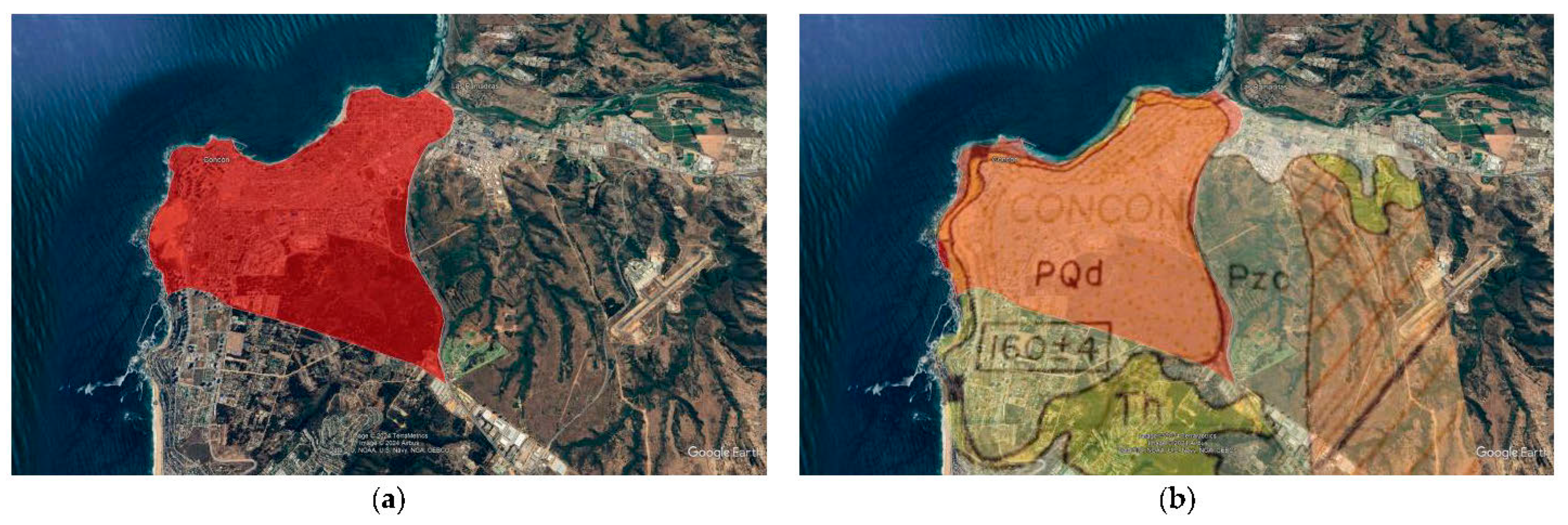
The city of Concón is located in the Valparaíso Region in central Chile (Figure 1a). It has a population of 42,152 inhabitants, distributed over an area of 72 km2, with the urban sector, as defined by the city’s master plan, covering 11.6 km2. Given the significant real estate expansion previously mentioned, the study area focused on the urban sector of the city of Concón, which is shown in Figure 2.
Geologically, the city of Concón is composed, towards the coastal sector to the west by the Cochoa Unit (Pzc: defined as Paleozoic granites), to the south by the Horcón Formation (Th: sandstone, mudstone, and siltstone or Cenozoic Tertiary sedimentary rocks), and finally by the most superficial stratum, corresponding mainly to eolian dune sand deposits (PQd: ancient eolian sediments or Paleodunes from the Quaternary Cenozoic) [31,32,33]. This last unit encompasses the urban area of the city, which is the focus of this case study (Figure 2a,b) and is also present in the form of semi-stabilized fossil dunes [32]. In the area, the natural beach sectors along the coast of Concón are interrupted by some artificial fill or by rocky outcrops. The field inspection of the exposed rock sectors has been an important reference point for estimating the location of the bedrock and its subsequent use in the 3D numerical model of the present study.
Figure 2. (a) Location of the urban area of Concón according to the city’s master plan; (b) Superposition of a simplified geological map of the city of Concón according to [33], adapted by the authors. Base images taken from Google Earth. Image data © 2024 Google, © 2024 TerraMetrics.
Applsci 14 08458 g002

2.2. Field Measurement Procedures and Methods

For the measurement campaign of the fundamental period, T, the HVSR method was used, which establishes that a pseudo-transfer function can be defined by the ratio between the horizontal and vertical components of the Fourier amplitude spectra of ambient vibrations recorded at the ground surface in free-field conditions [28]. Assuming that the vertical and horizontal components of the motion are radial at the level of the bedrock, and that only the horizontal component of the waves recorded at the surface is amplified due to wave propagation in soil layers, the period at which the largest peak of the H/V ratio occurs approximates the value of T. Although this interpretation has been questioned by some authors who attribute the maximum values in the H/V ratio to the hyperbolic propagation of Rayleigh waves [34,35], most studies agree that the method is suitable for identifying T, even in terrains with irregular topography such as those found in certain sectors of the city of Concón, particularly in the dune field [36,37,38,39].
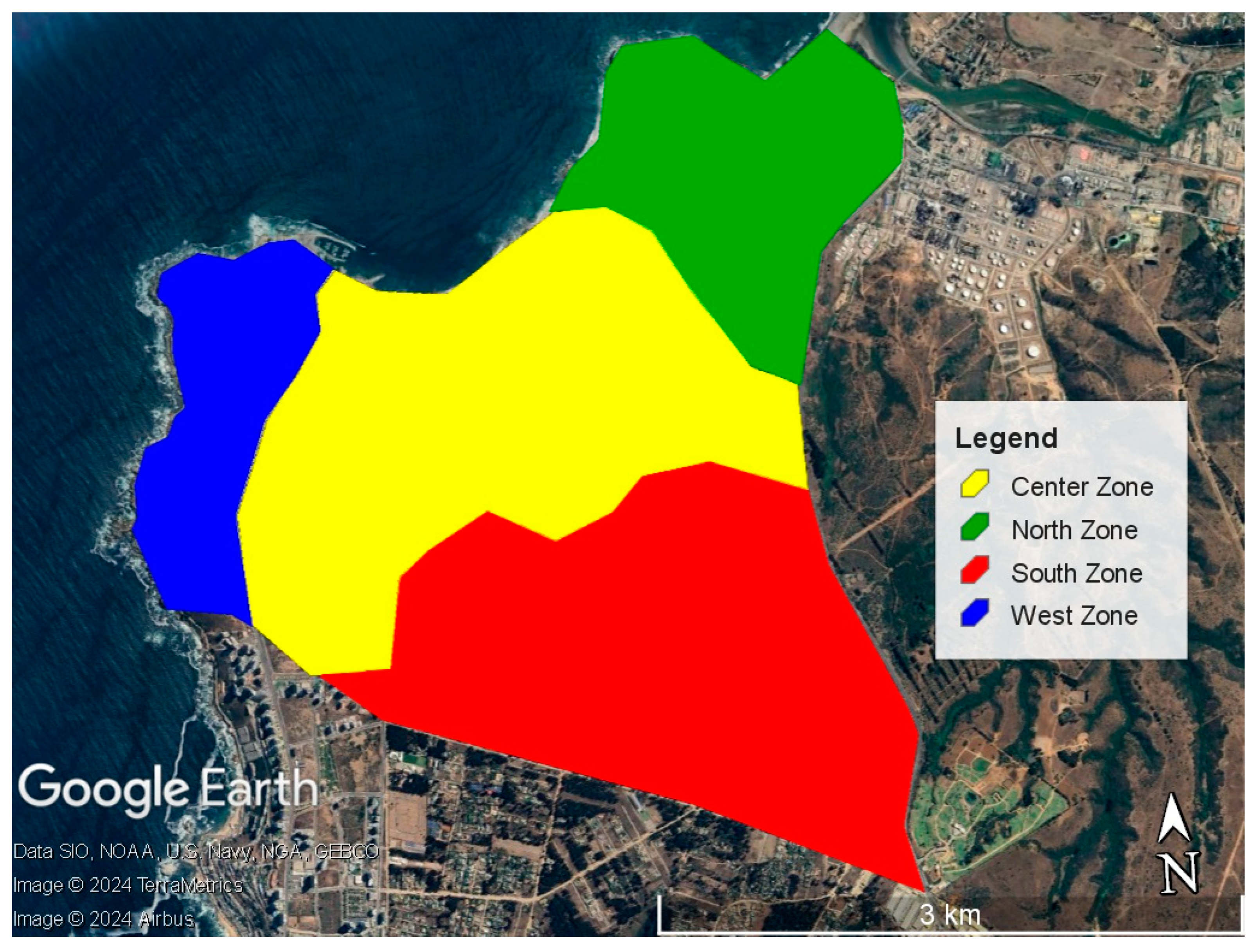
Considering the coverage area, the measurement campaign was divided into four zones, the areas of which are shown in Figure 3. Although the subdivision of the zones was primarily carried out for accessibility reasons rather than geomorphological conditions, the measurement points were strategically located to ensure spatial distribution across the different geomorphological units present in the city of Concón. This approach allowed us to cover both the dune deposit and coastal areas, ensuring that local variations and regional trends were adequately captured. Additionally, the points where rock outcrops were observed were surveyed and recorded, primarily in the coastal sector.
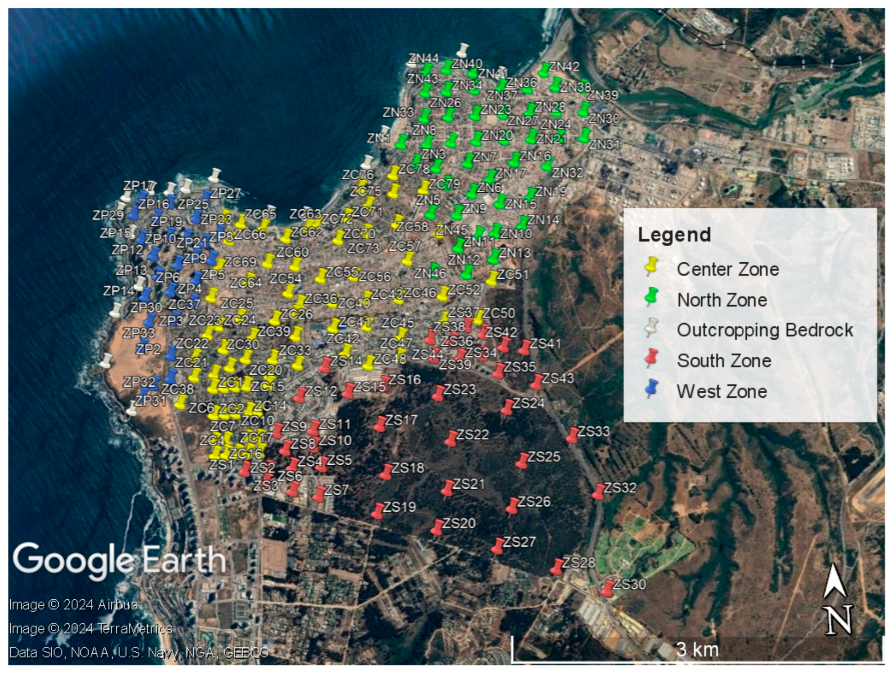
Field measurements were conducted using two Tromino Engy® devices (MOHO VEGA, edificio Lybra|Via delle Industrie 17/A–30175 Venice, Italy), which are high-sensitivity seismographs equipped with three orthogonal velocity and acceleration channels, capable of measuring frequency ranges from 0.1 Hz to 1024 Hz. A total of 208 measurement points were located, as shown in Figure 4, representing a density of 17.9 measurements per square kilometer, which results in a spacing between measurements that is smaller than the recommendations for microzonation studies proposed by the SESAME manual [40], where an initial spacing of 500 m between two adjacent recording points is suggested. Additionally, 2 to 3 measurements were taken at each point, using a sampling rate of 256 samples per second (sps), with a recording time of 16 to 20 min, resulting in more than 450 measurements in total.

2.3. Analysis Methodology for Approach for Analyzing Regional Seismic Response

With the aim of expanding the use of microzonation, a methodology is proposed that integrates the analysis of the measurements taken, along with all the geotechnical and geomorphological data collected in the field, for the generation of a 3D model of the entire urban area of the city.
Based on a regional 3D model that includes the corresponding terrain characterization, it is possible to construct a 3D FEM which, combined with the interpretation of the microzonation campaign, can be used as a tool for the early-stage identification of potential singular seismic response effects in a project. This is possible because, through the numerical model, and despite the inherent associated uncertainties, it is possible to simulate the regional dynamic response [41] and thereby record response spectra for any point in the city, allowing for the comparison of spatial variations in seismic response. Such variations can be generated by highly irregular geometries, singularities in the bedrock, or even by topographic effects, among other factors [4,9,10].
Additionally, these spectra can also be compared with design spectra to identify areas with potential singular responses or higher demands than those defined in the design code for the study area. This would be highly useful for detecting and justifying the need to adapt a specific structural design to the site-specific conditions.
Finally, the proposed methodology justifies its implementation due to its ability to capture local variations that might not be detected in more general seismic studies. This is especially relevant in areas like Concón, where the geomorphological conditions of the dune deposit can significantly influence structural behavior.

3. Results

3.1. Zonation Map and Estimation of Bedrock Depth

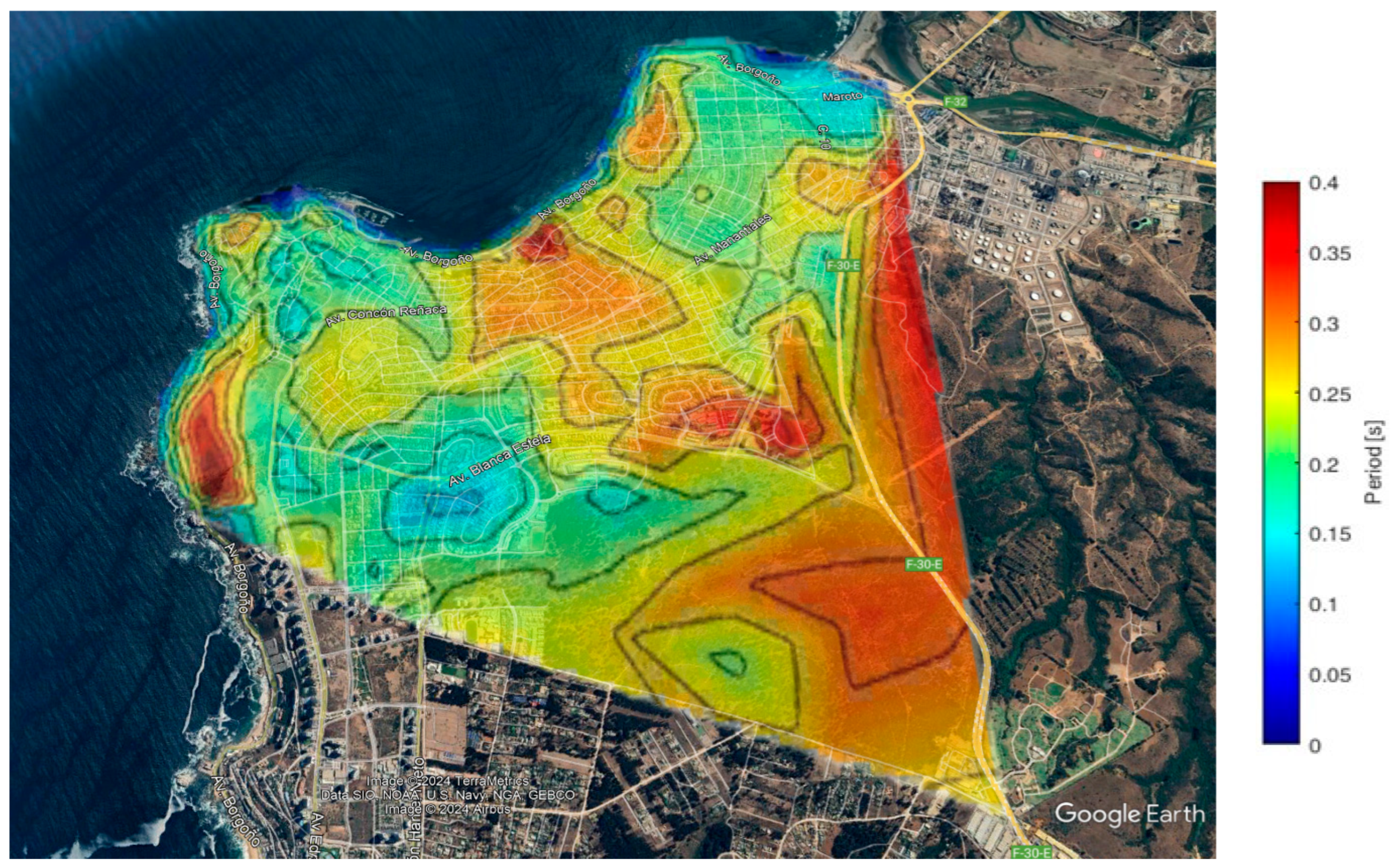
After processing and refining all the measurements conducted, a zonation map was created in terms of the period T, recorded using the HVSR method, as shown in Figure 5. Thanks to the high density of measurement points, the map provides a significant level of detail, allowing for a more thorough assessment of geological conditions and facilitating the subsequent creation of a numerical model for evaluating the seismic response of the city. In Figure 5, it can also be observed that the T values in the study area range from 0.15 s to 0.4 s. This variability suggests a relative homogeneity in the underlying geological conditions.
One of the key challenges in regional characterization processes is the identification of the bedrock, which cannot always be detected through the usual measurements for a given project. In the specific case of Concón, the use of the measured periods along with geological information and visual inspection of exposed rock areas, complemented by the application of the method contained in the Japanese code for determining the period in a stratified condition [25], allowed for the definition of the bedrock location throughout the entire study area.
From the perspective of the bedrock, Manriquez [32] report that the Concón dune eolian sand deposit lies above a marine terrace of Paleozoic granites that extends between approximately 25 m and 80 m above sea level, following the geomorphological profile shown in Figure 6, which suggests that abrupt changes in the bedrock topography are not expected within the study area. This may explain the limited variation between the maximum and minimum periods recorded across the entire study area, where the most significant variations can be primarily attributed to the topographical conditions of the region, such as the Holocene dune area located to the west, as shown in Figure 7.
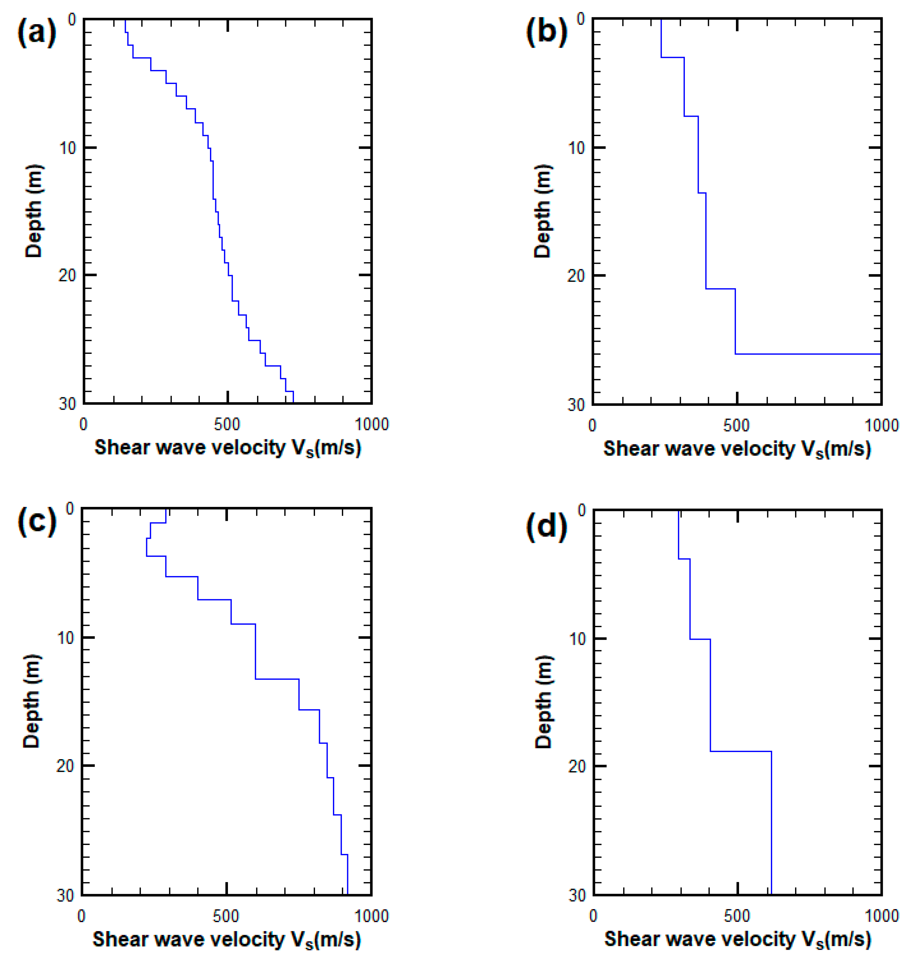
Considering these characteristics, a survey of geophysical tests conducted in the city for various real estate projects, for which permission for use was granted, was carried out, resulting in more than 20 shear wave velocity (Vs) profiles being obtained. A characteristic vs. profile for each zone is shown for reference in Figure 8. Considering the geological model recorded in the area, and the cross-referencing of complementary geophysical information with the periods measured during the microzonation campaign, it was deemed possible to apply the equation proposed in the Japanese standards for period estimation (Equation (1)), allowing the measured T periods to be matched, thereby enabling back analysis for estimating the bedrock location at the 208 measured points. The average depth of the bedrock location was recorded as 26 m with a standard deviation of 8.2 m, which is consistent with the characteristic velocity profiles shown in Figure 8. The following equation was used for this purpose [25]:
T E = 32 i = 1 L h i ( H i 1 + H i 2 ) V s i 2
where L represents the number of soil layers existing between the base of the foundation and the rock soil, and hi, Hi and Vs−i represent respectively the thickness, depth, and shear wave propagation velocity of the i-th soil layer.
Using all the collected data, the depth of the bedrock was estimated by correlating the measured periods with the estimated periods, using Equation (1), through an iterative process that resulted in a determination coefficient of R2 = 0.9963, as shown in Figure 9.

3.2. Development of the Three-Dimensional Finite Element Model, 3D FEM

Based on the mapping of all recorded soil periods, along with the collection of background information on the study area—specifically regarding shear wave velocity and areas with rock outcrops—a potential model of the spatial distribution of bedrock in the explored area of Concón was generated. This information, combined with the topographic survey and bathymetry of the area, enabled the creation of a three-dimensional model of the explored area, encompassing the urban limits of the municipality of Concón. The model was created with an area larger than the urban zone to establish boundary conditions, resulting in dimensions of 4150 m by 4600 m.
For subsequent modeling of the seismic response, the 3D FEM was developed using Plaxis 3D V2023, specialized software for geotechnical simulations [42]. In order to consider a more comprehensive soil response for this case study, the soil behavior was represented using the Hardening Soil with Small Strain (HSSS) constitutive model [43]. This model allows for the incorporation of the nonlinear stiffness degradation that occurs in the soil as strain amplitude increases. The model parameters were derived from field tests, including shear wave velocity (Vs) profiles obtained from geophysical tests conducted in various zones across the study area, as well as laboratory data. These parameters were further supplemented by information collected from previous projects carried out in the sector, ensuring an accurate representation of the local geotechnical conditions. Based on all the background information about the dune soil deposit, which exhibits a relatively homogeneous profile throughout the study area, the HSSS parameters for the Concón dune soil were obtained and are shown in Table 1. For the marine terrace composed of granite, on which the eolian deposit primarily rests, a bedrock with stiffness was considered, with a velocity recorded through geophysical tests, resulting in an average value of 1200 m/s. This information is of great importance, as it allowed for the inclusion of impedance contrast effects between the soil and the rock.
In addition to the bedrock input, the 3D FEM employed specific boundary conditions to ensure the proper simulation of seismic wave propagation. The lateral boundaries of the model were assigned “free-field” conditions, which allow for the simulation of seismic wave propagation as if the model were part of a larger region, reducing reflections at the edges. For the bottom boundary, a “compliant base” condition was applied, designed to absorb upward-propagating seismic waves and minimize wave reflection at the base of the model. This condition allows for the direct application, i.e., upward propagation, of an input accelerogram without interference caused by waves reflected from the upper layers [42].
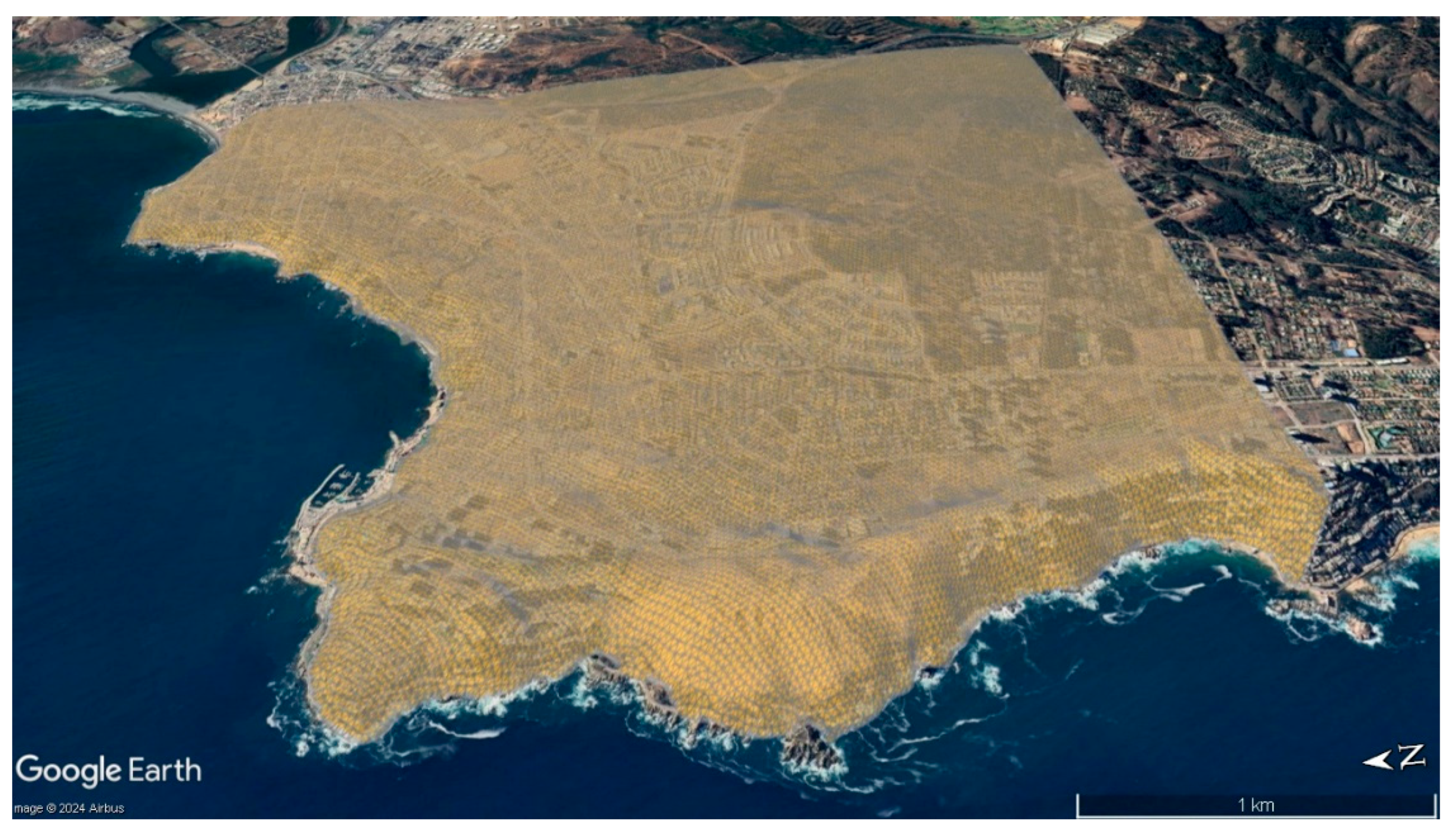
For the FEM’s meshing, 10-node tetrahedral elements were used, with an average size of 33 m across the entire area, which is a notable magnitude given the model’s dimensions and allows for the adequate recording of wave propagation throughout the domain. The mesh used, which is shown referentially superimposed on the city map in Figure 10, was constructed with a total of 673,000 elements.
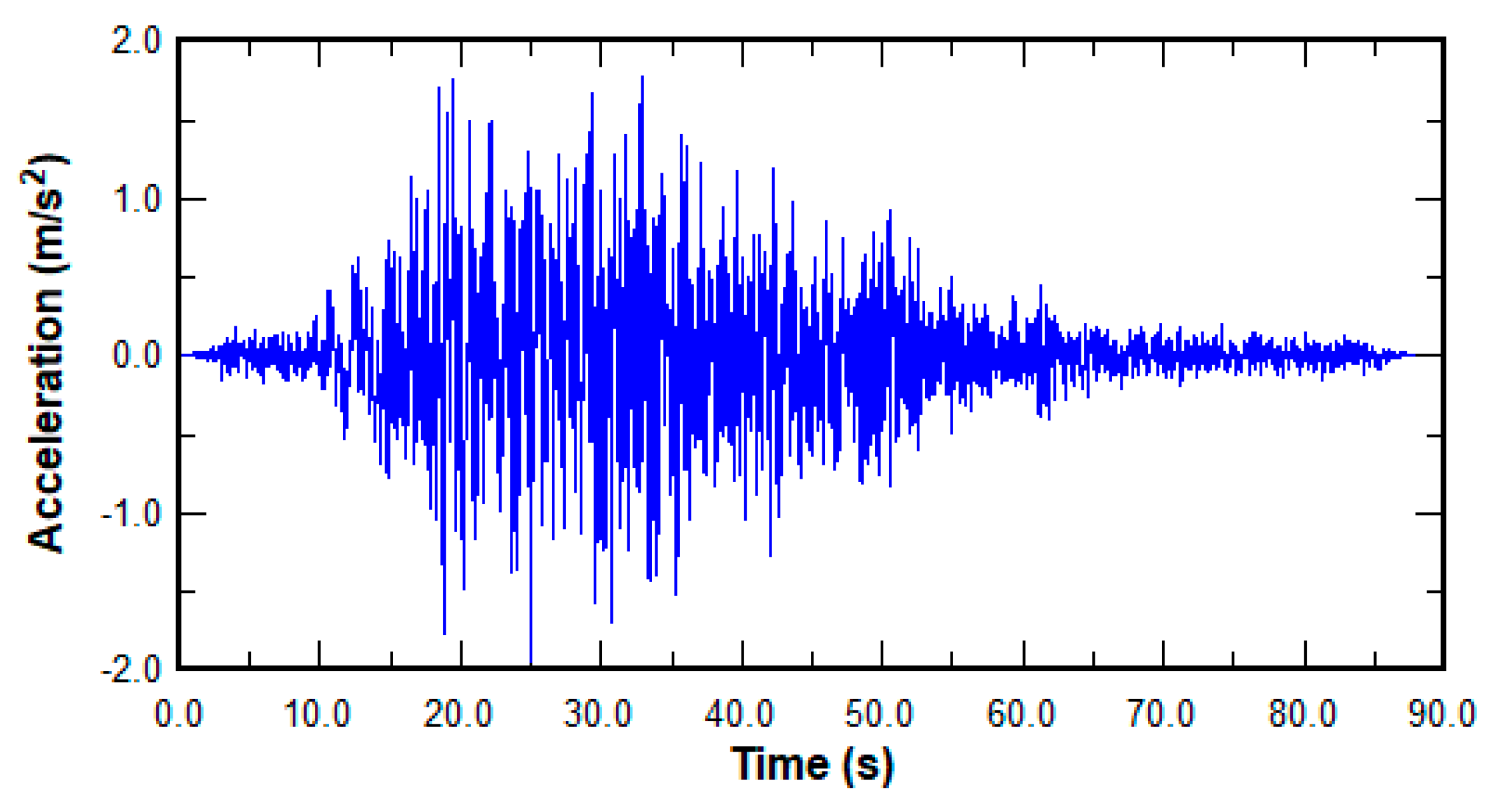
To evaluate the regional seismic response, the acceleration record of the 2010 Maule earthquake in Chile, Mw = 8.8, measured on bedrock at the Rapel seismological station, was used as the signal [44]. The characteristics of the signal used are shown in Table 2 and Figure 11. This record was applied at the base of the model beneath the bedrock, using a time step equal to the sampling period of the signal; that is, 0.005 s per step.
Since the free-field surface motion on a rock outcrop is typically amplified compared to the motion at the bedrock due to the absence of overlying soil, the seismic record must be scaled down to accurately reflect bedrock conditions. In this study, the record was reduced using a factor of 0.5 before applying it at the base of the FEM in Plaxis 3D. This adjustment ensures that the model accurately simulated the propagation of seismic waves through the underlying strata, following standard practice for modeling seismic responses at the bedrock level [24]. Additionally, to optimize modeling time, which is a crucial aspect given the characteristics of the model, a significant duration of the earthquake was defined based on the concentration between 5% and 95% of the Arias Intensity, allowing the record to be reduced to 34 s [45].
Additionally, response spectra were determined at the locations corresponding to the different measurement points distributed throughout the city. These were individually evaluated for each zone of the 3D model, allowing a comparison between the obtained results and the normative design spectra. These additional details provide a better understanding of the methodology used, as well as the analysis techniques applied to assess the seismic response at each point in the study.

3.3. Evaluation of Regional Seismic Response

Seismic microzonation studies have led to improvements in the information contained in seismic design codes, providing a precise framework for risk assessment and urban planning in seismically active areas. One such improvement has involved seismic site classification methods based on the average shear wave velocity in the top 30 m (Vs30), as well as the fundamental vibration period of the soil, T, to better align seismic design codes with local geological conditions [18,19]. The multiscale and multidisciplinary approach applied has highlighted the need to consider soil nonlinearity and the depth of seismic bedrock in design codes, leading to the adoption of more realistic amplification factors for seismic design in areas with complex geology [20]. Similarly, in Chile, seismic microzonation studies have recommended incorporating detailed geophysical analyses and in situ measurements to improve the accuracy of building codes, especially in areas where soil amplification can vary significantly over short distances [21,22,23]. The contribution of microzonation studies to the better application of performance-based design is also widely recognized [46]. In summary, the contributions of seismic microzonation studies are directly related to improvements in design standards [47,48,49,50], including in conditions of earthquake-induced hazards, such as landslides and other threats [51,52,53].
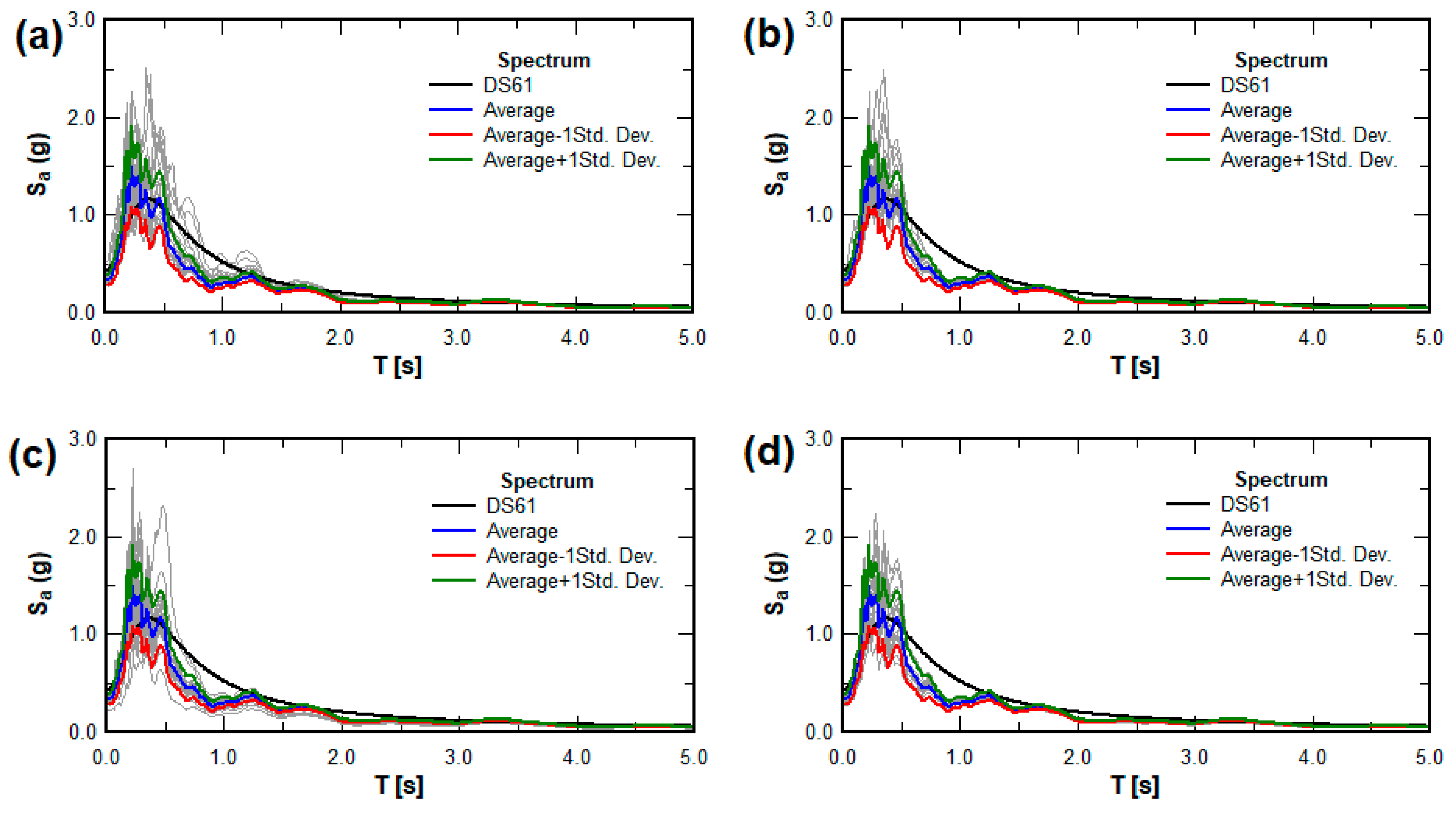
Figure 12 presents the pseudoacceleration spectra obtained from the 3D model, using data from the 208 measurement points, which have been divided according to the zones defined in the measurement campaign. As shown in Figure 12, the seismic response does not exhibit abrupt changes across the studied area, which is consistent with the discussion in Section 3.1 regarding bedrock topography. It is important to note that, when comparing the average spectra obtained from the model with the design spectra from the standards, it is observed that in the West Zone, where the dune field with more irregular topography is located (Figure 7), the measured spectra exceed the design spectrum over a broader range of periods, with this effect even being recorded for periods greater than 1.0 s. This difference suggests greater amplification in this zone, which could have significant implications for structural design in similar areas.
While the 3D model can accurately represent the response in areas where both the surface and bedrock relief are horizontal, in sectors with local singularities, the 3D model makes it difficult to achieve sufficient refinement to capture variations in the response due to these singularities with greater precision. For these areas where more precise analysis is required, it is suggested to conduct two-dimensional analyses of cross-sectional and longitudinal profiles. These analyses will allow for better mesh refinement and a significant reduction in computational resource consumption, thereby increasing the accuracy of the results.

4. Discussion

It is important to highlight that the proposed methodology and the results obtained are not intended to replace the design spectra established by regulations, which would be complex from a regulatory standpoint. However, the methodology is useful as an early warning tool for potential local effects. This can allow, for instance, the improvement of exploration programs or the adjustment of structural design criteria to better adapt to the specific site conditions.
The methodological approach used in this study could be replicated in other cities, adapting it to local geological characteristics. This adaptability is one of the strengths of the approach, as it would not only be viable under the conditions of the city of Concón, but also utilizes a modeling framework that can be applied to areas with similar geological conditions, such as coastal terraces, dune deposits, or alluvial plains. For example, regions with coastal dune formations or areas prone to seismic activity could benefit from a similar integration of seismic microzonation and 3D FEM modeling, improving local risk assessments.
In the case of Concón, the model and the results obtained will be used as complementary inputs for the generation of seismic response information layers, which can be integrated into geographic information systems (GISs). Moreover, this procedure does not produce static models; as geotechnical exploration is enhanced, continuous adjustments can be made to develop a regional model that becomes a regular working tool for seismic design in the city.
Although this study focused on a 3D model to capture the regional seismic response in Concón, it is important to note that the implementation of 2D models could be a valuable complementary tool in future research. 2D models allow for greater local refinement of the FEM mesh, which is particularly useful in areas with complex geometries or specific geotechnical characteristics. These models could focus on critical areas identified by the 3D model, providing a more detailed analysis of soil–structure interaction and allowing for more precise adjustments in structural design. The integration of 2D models in subsequent studies could therefore enhance the ability to predict seismic response in localized areas, further optimizing seismic risk mitigation strategies in the region. In summary, the use of the generated 3D model will allow microzonation data to be used to simulate the response of the soil and structures in various hypothetical earthquake scenarios. This could include different magnitudes and focal depths, providing a broader range of data for seismic risk management planning in the locality.

5. Conclusions

Seismic zonation alone is not necessarily sufficient, as there may be variations inherent to local conditions that are not fully captured by general regulations. The procedure proposed in this study, while a valuable tool, requires additional analysis of the local response in singular zones to achieve a more precise seismic characterization. Regional modeling, combined with seismic zonation, provides a first approach to identifying these areas that may require more detailed exploration or the implementation of more specific local response analyses.
The microzonation campaign employed both nationally and internationally recognized techniques. However, the innovative aspect of this study lies in the integration of a three-dimensional finite element model (3D FEM) to simulate the dynamic behavior of the terrain. This approach enables a more granular identification of localized seismic effects that might otherwise go unnoticed, offering a refined methodology for assessing site-specific risks in regions with complex geology.
It is crucial to consider the practical implications of these results in the context of future constructions and the review of local regulations. The identification of areas with singular seismic responses allows for adjustments to be proposed in current building codes, which could include recommendations for reinforcing buildings or limiting development in particularly vulnerable areas. Similarly, these results contribute to expanding the database of microzonation studies conducted on dune soils, which are present in countries with diverse seismic characteristics such as India and the western United States. This allows for the comparison of characteristics and the assessment of the influence of climate changes on the properties of dune soils, which may affect dynamic response.
The results obtained in this study provide insight into how microzonation and seismic response analysis could influence urban planning and structural design in a city. In the case of the urban sector of Concón, the response spectra identified in different areas of the city reveal variations which, although not highly significant, could have direct implications for structural safety. Additionally, the results of this study may serve as a basis for correlating potential future damage to new and existing structures resulting from a strong earthquake affecting the locality.
Finally, regarding community resilience, the seismic microzonation study presents the following challenges:
  • Highlighting the need for public education programs and professional training in the interpretation and application of microzonation maps to ensure that risks are adequately integrated into planning and construction.
  • Concluding on how the integration of seismic microzonation into urban planning and disaster risk management can significantly improve safety and resilience in seismically active areas. This is particularly relevant, as highlighted in recent studies that emphasize the role of resilience in geotechnical engineering and urban infrastructure [54].

Author Contributions

Conceptualization, E.G.D.-S., J.C.V. and J.E.O.-V.; methodology, E.G.D.-S., J.C.V. and J.E.O.-V.; software, E.G.D.-S. and J.E.O.-V.; validation, E.G.D.-S., J.C.V. and J.E.O.-V.; formal analysis, E.G.D.-S., J.C.V. and J.E.O.-V.; data curation, J.E.O.-V. and E.G.D.-S.; field measurement campaign: J.E.O.-V.; writing—original draft preparation, E.G.D.-S. and J.C.V.; writing—review and editing, E.G.D.-S., J.C.V. and J.E.O.-V.; funding acquisition, J.C.V. and E.G.D.-S. All authors have read and agreed to the published version of the manuscript.

Funding

This research was funded by Proyecto Microzonificación Sísmica de la Ciudad de Concón como Herramienta para el Diseño Sísmico de Estructuras. IPGH. IGCP GEOF 02-2021. Proyecto Seismic vulnerability of buildings located on hillsides. Case study: Latin American Countries. Council of the International Geoscience Programme UNESCO. Project number 701: 2020-2022.

Institutional Review Board Statement

Not applicable.

Informed Consent Statement

Not applicable.

Data Availability Statement

Data generated or analyzed during this study are available from the corresponding author upon reasonable request.

Acknowledgments

The authors thank the Civil Engineering School of Pontificia Universidad Católica de Valparaíso for the support provided in the development of this research, as well as the support in the publication of this article. The authors also wish to express their gratitude to student Aníbal Arriagada for his valuable support in conducting field measurements.

Conflicts of Interest

The authors declare no conflicts of interest.

References

  1. Marino, E.M.; Nakashima, M.; Mosalam, K.M. Comparison of European and Japanese seismic design of steel building structures. Eng. Struct. 2005, 27, 827–840. [Google Scholar] [CrossRef]
  2. Diaz-Segura, E.G. Evolution of Seismic Site Classification According to the Criteria in Chilean Design Codes. Appl. Sci. 2021, 11, 10754. [Google Scholar] [CrossRef]
  3. Lai, C.G.; Bozzoni, F.; Conca, D.; Famà, A.; Özcebe, A.G.; Zuccolo, E.; Meisina, C.; Bonì, R.; Bordoni, M.; Cosentini, R.M.; et al. Technical Guidelines for the Assessment of Earthquake Induced Liquefaction Hazard at Urban Scale. Bull. Earthq. Eng. 2021, 19, 4013–4057. [Google Scholar] [CrossRef]
  4. Mittal, K. Seismic Microzonation: A Case Study. Civ. Eng. Res. J. 2017, 1, 555565. [Google Scholar] [CrossRef]
  5. Anbazhagan, P. Method for Seismic Microzonation with Geotechnical Aspects. Disaster Adv. 2013, 6, 66–85. [Google Scholar]
  6. Cardona, O.D.; Yamín, L.E. Seismic Microzonation and Estimation of Earthquake Loss Scenarios: Integrated Risk Mitigation Project of Bogotá, Colombia. Earthq. Spectra 1997, 13, 795–814. [Google Scholar] [CrossRef]
  7. Calderon, D.; Aguilar, Z.; Lazares, F.; Alarcon, S.; Quispe, S. Development of a Seismic Microzoning Map for Lima City and Callao, Peru. J. Disaster Res. 2014, 9, 939–945. [Google Scholar] [CrossRef]
  8. Ansal, A.; Kurtuluş, A.; Tönük, G. Seismic Microzonation and Earthquake Damage Scenarios for Urban Areas. Soil Dyn. Earthq. Eng. 2010, 30, 1319–1328. [Google Scholar] [CrossRef]
  9. James, N.; Sitharam, T.G.; Padmanabhan, G.; Pillai, C.S. Seismic Microzonation of a Nuclear Power Plant Site with Detailed Geotechnical, Geophysical and Site Effect Studies. Nat. Hazards 2014, 71, 419–462. [Google Scholar] [CrossRef]
  10. Moscatelli, M.; Albarello, D.; Scarascia Mugnozza, G.; Dolce, M. The Italian Approach to Seismic Microzonation. Bull. Earthq. Eng. 2020, 18, 5425–5440. [Google Scholar] [CrossRef]
  11. Lee, V.W.; Trifunac, M.D.; Bulajić, B.D.; Manić, M.I.; Herak, D.; Herak, M.; Dimov, G. Seismic Microzoning in Skopje, Macedonia. Soil Dyn. Earthq. Eng. 2017, 98, 166–182. [Google Scholar] [CrossRef]
  12. di Lernia, A.; Papadimitriou, A.G.; Elia, G. Approximate Decoupling of Topographic, Stratigraphic and Valley Effects on the Peak Seismic Acceleration. Soil Dyn. Earthq. Eng. 2024, 183, 108758. [Google Scholar] [CrossRef]
  13. Assimaki, D.; Pecker, A.; Popescu, R.; Prevost, J. Effects of spatial variability of soil properties on surface ground motion. J. Earthq. Eng. 2003, 7, 1–44. [Google Scholar] [CrossRef]
  14. Bour, M.; Fouissac, D.; Dominique, P.; Martin, C. On the Use of Microtremor Recordings in Seismic Microzonation. Soil Dyn. Earthq. Eng. 1998, 17, 465–474. [Google Scholar] [CrossRef]
  15. Lai, C.G.; Poggi, V.; Famà, A.; Zuccolo, E.; Bozzoni, F.; Meisina, C.; Bonì, R.; Martelli, L.; Massa, M.; Mascandola, C.; et al. An Inter-Disciplinary and Multi-Scale Approach to Assess the Spatial Variability of Ground Motion for Seismic Microzonation: The Case Study of Cavezzo Municipality in Northern Italy. Eng. Geol. 2020, 274, 105722. [Google Scholar] [CrossRef]
  16. Mohanty, W.K.; Walling, M.Y.; Nath, S.K.; Pal, I. First Order Seismic Microzonation of Delhi, India Using Geographic Information System (GIS). Nat. Hazards 2007, 40, 245–260. [Google Scholar] [CrossRef]
  17. Régnier, J.; Bertrand, E.; Cadet, H. Repeatable Process for Seismic Microzonation Using 1-D Site-Specific Response Spectra Assessment Approaches. Application to the City of Nice, France. Eng. Geol. 2020, 270, 105569. [Google Scholar] [CrossRef]
  18. Salsabili, M.; Saeidi, A.; Rouleau, A.; Nastev, M. Seismic Microzonation of a Region with Complex Surficial Geology Based on Different Site Classification Approaches. Geoenvironmental Disasters 2021, 8, 27. [Google Scholar] [CrossRef]
  19. Molnar, S.; Assaf, J.; Sirohey, A.; Adhikari, S.R. Overview of Local Site Effects and Seismic Microzonation Mapping in Metropolitan Vancouver, British Columbia, Canada. Eng. Geol. 2020, 270, 105568. [Google Scholar] [CrossRef]
  20. Licata, V.; Forte, G.; d’Onofrio, A.; Santo, A.; Silvestri, F. A Multi-Level Study for the Seismic Microzonation of the Western Area of Naples (Italy). Bull. Earthq. Eng. 2019, 17, 4711–4741. [Google Scholar] [CrossRef]
  21. Becerra, A.; Podestá, L.; Monetta, R.; Sáez, E.; Leyton, F.; Yañez, G. Seismic Microzoning of Arica and Iquique, Chile. Nat. Hazards 2015, 79, 567–586. [Google Scholar] [CrossRef]
  22. Leyton, F.; Ruiz, S.; Sepúlveda, S.A.; Contreras, J.P.; Rebolledo, S.; Astroza, M. Microtremors’ HVSR and Its Correlation with Surface Geology and Damage Observed after the 2010 Maule Earthquake (Mw 8.8) at Talca and Curicó, Central Chile. Eng. Geol. 2013, 161, 26–33. [Google Scholar] [CrossRef]
  23. Podestá, L.; Sáez, E.; Yáñez, G.; Leyton, F. Geophysical Study and 3-D Modeling of Site Effects in Viña Del Mar, Chile. Earthq. Spectra 2019, 35, 1329–1349. [Google Scholar] [CrossRef]
  24. Kramer, S.L. Geotechnical Earthquake Engineering; Prentice-Hall: Upper Saddle River, NJ, USA, 1996; p. 653. [Google Scholar]
  25. Building Research Institute; Japan Society of Construction Engineering. Development of Earthquake Disaster Prevention in Urban Area; Building Research Center: Tokyo, Japan, 1997; p. 381. (In Japanese) [Google Scholar]
  26. CEN EuroCode 8; Design of Structure for Earthquake Resistance–Part 1: General Rules for Buildings; European Committee for Standardization: Bruxelles, Belgium, 2003.
  27. INN. NCh 433: Diseño Sísmico de Edificios; Instituto Nacional de Normalización: Santiago, Chile, 2009. [Google Scholar]
  28. Nakamura, Y. A Method for Dynamic Characteristics Estimation of Subsurface Using Microtremor on the Ground Surface. Q. Rep. RTRI 1989, 30, 25–33. [Google Scholar]
  29. Nogoshi, M.; Igarashi, T. On the Amplitude Characteristics of Microtremor (Part 2). J. Seismol. Soc. Jpn. 2nd Ser. 1971, 24, 26–40. [Google Scholar] [CrossRef]
  30. Bard, P.-Y.; Riepl-Thomas, J. Wave Propagation in Complex Geological Structures and Their Effects on Strong Ground Motion; WIT Press: Southampton, UK, 1999; Chapter 2; pp. 38–95. [Google Scholar]
  31. Grimme, K.; Álvarez, L. El suelo de fundación de Valparaíso y Viña del Mar: Geología del área Valparaíso-Viña del Mar; Instituto de Investigaciones Geológicas: Santiago, Chile, 1964; Boletín 16. [Google Scholar]
  32. Manriquez, H. Dunas de Concón, un Recurso Escaso y Milenario. Ciencia para la Ciudad. Available online: https://cienciaparalaciudad.cl/medioambiente/dunas-de-concon-un-recurso-escaso-y-milenario/ (accessed on 1 February 2024).
  33. Rivano, G.S.; Sepúlveda, H.P.; Boric, P.R.; Espiñeira, T.D. Hojas Quillota y Portillo; SERNAGEOMIN: Santiago, Chile, 1993. [Google Scholar]
  34. Foti, S.; Lai, C.G.; Rix, G.J.; Strobbia, C. Surface Wave Methods for Near-Surface Site Characterization; CRC Press: London, UK, 2014; pp. 1–460. [Google Scholar] [CrossRef]
  35. Arai, H.; Tokimatsu, K. Evaluation of Local Site Effects Based on Microtremor H/V Spectra. In Proceedings of the 2nd International Symposium on The Effects of Surface Geology on Seismic Motion, Yokohama, Japan, 1–3 December 1998. [Google Scholar]
  36. Lermo, J.; Chavez-Garcia, F.J. Site Effect Evaluation Using Spectral Ratios with Only One Station. Bull. Seismol. Soc. Am 1993, 83, 1574–1594. [Google Scholar] [CrossRef]
  37. Chávez-García, F.J.; Sánchez, L.R.; Hatzfeld, D. Topographic Site Effects and HVSR. A Comparison between Observations and Theory. Bull. Seismol. Soc. Am. 1996, 86, 1559–1573. [Google Scholar] [CrossRef]
  38. Matsushima, S.; Hirokawa, T.; De Martin, F.; Kawase, H.; Sánchez-Sesma, F.J. The Effect of Lateral Heterogeneity on Horizontal-to-Vertical Spectral Ratio of Microtremors Inferred from Observation and Synthetics. Bull. Seismol. Soc. Am. 2014, 104, 381–393. [Google Scholar] [CrossRef]
  39. Diaz-Segura, E.G. Numerical Estimation and HVSR Measurements of Characteristic Site Period of Sloping Terrains. Geotech. Lett. 2016, 6, 176–181. [Google Scholar] [CrossRef]
  40. SESAME. Guidelines for the Implementation of the H/V Spectral Ratio Technique on Ambient Vibrations Measurements, Processing and Interpretation; SESAME European Research Project WP12, 2004; p. 62. Available online: https://sesame.geopsy.org/Delivrables/Del-D23-HV_User_Guidelines.pdf (accessed on 15 September 2024).
  41. Bard, P.Y. Microtremor Measurements: A Tool for Site Effect Estimation? Balkema: Rotterdam, The Netherlands, 1999; Volume 3, pp. 1251–1279. [Google Scholar]
  42. Bentley Systems. PLAXIS 3D 2024.2: 2—Reference Manual; Bentley Systems: Dublin, Ireland, 2024. [Google Scholar]
  43. Bentley Systems. PLAXIS 3D 2024.2: 3—Material Models; Bentley Systems: Dublin, Ireland, 2024. [Google Scholar]
  44. Center for Engineering Strong Motion. Available online: https://www.strongmotioncenter.org/ (accessed on 22 August 2024).
  45. Trifunac, M.D.; Brady, A.G. A Study on the Duration of Strong Earthquake Ground Motion. Bull. Seismol. Soc. Am. 1975, 65, 581–626. [Google Scholar]
  46. Lee, V.W.; Manić, M.I.; Bulajić, B.D.; Herak, D.; Herak, M.; Trifunac, M.D. Microzonation of Banja Luka for Performance-Based Earthquake-Resistant Design. Soil Dyn. Earthq. Eng. 2015, 78, 71–88. [Google Scholar] [CrossRef]
  47. Adhikari, S.R.; Molnar, S.; Wang, J. Seismic Microzonation Mapping of Greater Vancouver Based on Various Site Classification Metrics. Front. Earth Sci. 2023, 11, 1221234. [Google Scholar] [CrossRef]
  48. Moustafa, S.S.R.; Abdalzaher, M.S.; Naeem, M.; Fouda, M.M. Seismic Hazard and Site Suitability Evaluation Based on Multicriteria Decision Analysis. IEEE Access 2022, 10, 69511–69530. [Google Scholar] [CrossRef]
  49. Trifunac, M.D. A Microzonation Method Based on Uniform Risk Spectra. Soil Dyn. Earthq. Eng. 1990, 9, 34–43. [Google Scholar] [CrossRef]
  50. Caielli, G.; de Franco, R.; Di Fiore, V.; Albarello, D.; Catalano, S.; Pergalani, F.; Cavuoto, G.; Cercato, M.; Compagnoni, M.; Facciorusso, J.; et al. Extensive Surface Geophysical Prospecting for Seismic Microzonation. Bull. Earthq. Eng. 2020, 18, 5475–5502. [Google Scholar] [CrossRef]
  51. Shano, L.; Raghuvanshi, T.K.; Meten, M. Landslide Susceptibility Evaluation and Hazard Zonation Techniques—A Review. Geoenviron. Disasters 2020, 7, 18. [Google Scholar] [CrossRef]
  52. Meng, Q.; Li, Y.; Wang, W.; Chen, Y.; Wang, S. A Case Study Assessing the Liquefaction Hazards of Silt Sediments Based on the Horizontal-to-Vertical Spectral Ratio Method. J. Mar. Sci. Eng. 2023, 11, 104. [Google Scholar] [CrossRef]
  53. Stanko, D.; Sović, I.; Belić, N.; Markušić, S. Analysis of Local Site Effects in the Međimurje Region (North Croatia) and Its Consequences Related to Historical and Recent Earthquakes. Remote Sens. 2022, 14, 4831. [Google Scholar] [CrossRef]
  54. Huang, Z.; Cheng, Y.; Zhang, D.; Yan, D.; Shen, Y. Seismic Fragility and Resilience Assessment of Shallowly Buried Large-Section Underground Civil Defense Structure in Soft Soils: Framework and Application. Tunn. Undergr. Space Technol. 2024, 146, 105640. [Google Scholar] [CrossRef]
Figure 1. Location and characteristics of the study area, Concón, Chile. (a) View of Chilean territory; (b) Aerial view of the city of Concón, Chile; (c) View of real estate development in Concón in 2004; (d) View of increased real estate development in Concón in 2024. Images taken from Google Earth. Image data © 2004 and 2024 Google, © 2004 and 2024 TerraMetrics.
Applsci 14 08458 g001
Figure 3. Overlay of the work zones from the measurement campaign on the map of Concón, adapted by the authors. Base images from Google Earth. Image data © 2024 Google, © 2024 TerraMetrics.
Applsci 14 08458 g003
Figure 4. Location of measurement points using the HVSR method in each zone over a map of Concón adapted by the authors. Base image taken from Google Earth. Image data © 2024 Google, © 2024 TerraMetrics.
Applsci 14 08458 g004
Figure 5. Superposition of the isoperiod map obtained for the city of Concón, Chile, adapted by the authors. Base image taken from Google Earth. Image data © 2024 Google, © 2024 TerraMetrics.
Applsci 14 08458 g005
Figure 6. Geomorphological profile of the Concón dune deposit. Adapted from [32].
Applsci 14 08458 g006
Figure 7. View of dune deposit located to the west (source: the authors).
Applsci 14 08458 g007
Figure 8. Shear wave velocity profiles characteristic of the zones from the measurement campaign shown in Figure 3. (a) West Zone; (b) Center Zone; (c) North Zone; (d) South Zone.
Applsci 14 08458 g008
Figure 9. Relationship between measured and estimated periods using Equation (1) for estimation of bedrock depth.
Applsci 14 08458 g009
Figure 10. Superposition of the finite element mesh of the 3D FEM over the map of the city of Concón, Chile, adapted by the authors. Base image taken from Google Earth. Image data © 2024 Google, © 2024 TerraMetrics.
Applsci 14 08458 g010
Figure 11. Seismic acceleration record used—Maule 2010 earthquake, Rapel Station, Chile [44].
Applsci 14 08458 g011
Figure 12. Comparison between response spectra obtained for all zones of the microzonation campaign and the design spectrum for the city of Concón. (a) West Zone; (b) Center Zone; (c) North Zone; (d) South Zone. In this Figure, gray lines represent the response spectrum in each measurement point.
Applsci 14 08458 g012
Table 1. Characteristic HSSS parameters determined for the dune deposit in the city of Concón.
ParameterValueUnit
γunsat18[kN/m3]
E50ref17,000[kN/m2]
EOEDref17,000[kN/m2]
EURref150,000[kN/m2]
υ0.35-
Power (m)0.5-
G0ref350,000[kN/m2]
γ0.70.000169-
c’ref4[kN/m2]
f36[°]
y0[°]
k00.4122-
Rayleigh α0.3427-
Rayleigh β0.000868-
Table 2. Characteristics of the earthquake considered in the regional response modeling.
Rapel Seismic Station
(Outcropping)
PGA
[g]
PGV
[cm/s]
PGD
[cm]
D5-95
[s]
Latitude
[°]
Longitude
[°]
Component NS
Mw. 8.8 (27 February 2010)
0.231.516.13434.03 S71.58
Disclaimer/Publisher’s Note: The statements, opinions and data contained in all publications are solely those of the individual author(s) and contributor(s) and not of MDPI and/or the editor(s). MDPI and/or the editor(s) disclaim responsibility for any injury to people or property resulting from any ideas, methods, instructions or products referred to in the content.