Article

Integrating Web-Based Weather Data into Building Information Modeling Models through Robot Process Automation

by
Edison Atencio
1,
Fidel Lozano
2,*,
Ignacio Alfaro
1,
Jose Antonio Lozano-Galant
3 and
Felipe Muñoz-La Rivera
1
1
School of Civil Engineering, Pontificia Universidad Católica de Valparaíso (PUCV), Valparaíso 2340000, Chile
2
Department of Civil and Environment Engineering, Universitat Politècnica de Catalunya (UPC), BarcelonaTech. C/Jordi Girona 1-3, 08034 Barcelona, Spain
3
Department of Civil Engineering, University of Castilla-La Mancha (UCLM), 13071 Ciudad Real, Spain
*
Author to whom correspondence should be addressed.
Appl. Sci. 2024, 14(19), 9109; https://doi.org/10.3390/app14199109
Submission received: 22 August 2024 / Revised: 26 September 2024 / Accepted: 2 October 2024 / Published: 9 October 2024

Abstract

:
The rapid evolution of digital technologies has revolutionized the architecture, engineering, and construction (AEC) industry, driving the wide-spread adoption of digital twins for structures. These virtual replicas, developed using Building Information Modeling (BIM) methodology, incorporate extensive information databases, proving indispensable for enhancing project management throughout a structure’s entire lifecycle and towards smart city development. As the impact of climate change continues to grow, hazardous weather alerts play a critical role as an early-warning system that notifies stakeholders of imminent threats, thereby influencing decision-making processes in construction projects. Surprisingly, despite its evident value, the integration of alert systems for hazardous weather conditions into BIM is often overlooked. To fill this gap, this paper proposes Robot Process Automation (RPA) protocols to automate the integration of real-time weather parameters into a structure’s BIM models. These very protocols are also used as alert systems, enabling the timely notification of stakeholders in the event of detected hazardous weather conditions. The effectiveness of the proposed methodology is demonstrated through its practical application in enhancing the safety of an actual building in Viña del Mar, Chile.

1. Introduction

In the context of the ongoing fourth industrial revolution, often referred as Industry 4.0 [1], the architecture, engineering, and construction (AEC) industry is undergoing a profound shift driven by digitalization. One prominent methodology at the forefront of this transformation is the pivotal role played by Building Information Modeling (BIM) [2], which enables the generation of digital twins (DTs) of physical assets, such as civil infrastructure and buildings [3]. The benefits of BIM include improved collaboration among project stakeholders, enhanced visualization of project details, reduced errors and rework, efficient resource allocation, and better decision-making throughout a construction project’s lifecycle [4]. The current implementation status, and forthcoming trends in the utilization of the BIM methodology within the AEC industry are detailed in [5,6,7], respectively.
It is essential to remark that BIM virtual replicas extend beyond the three-dimensional geometry of their elements, they are also enriched with multidisciplinary databases. Indeed, the integration of these databases empowers stakeholders to access and share precise and up-to-date information, resulting in improved project outcomes and more efficient project management [8]. Among the databases commonly integrated into BIM models are cost estimations [9], structural properties [10], scheduling information [11], sustainability data [12,13], environmental data [14,15], safety data [16], documentation, supplier and manufacturer data [6], and energy information [17,18].
Weather information refers to data and details about atmospheric conditions in a specific location at a given time. It includes a diverse range of meteorological parameters, including but not limited to temperature, humidity, precipitation, wind speed and direction, and tides. This valuable data are typically kept accessible on web servers, exemplified by worldwide platforms such as Weather.com [19] and AccuWeather [20]. This information is maintained and updated by specialized entities in meteorological forecasting, including government agencies, meteorological institutes, private weather service companies, and non-profit organizations dedicated to the collection and dissemination of meteorological data. In the current context, with the impacts of climate change on the rise, it is vital to underscore the pivotal role of meteorological forecasting in the decision-making processes of government officials [21]. Meteorological forecasts can offer early warnings about hazardous weather conditions, encompassing storms, tides, wildfires, and tornadoes [22]. In this regard, a recent event during February 2024 affecting urban sites in the Valparaiso region, Chile has been identified as the second deadliest catastrophe after the earthquake and tsunami of 2010 [23]. Furthermore, forecasted weather conditions can have a significant impact on a building’s performance, energy consumption, and safety. Surprisingly, despite its substantial influence, this valuable information is rarely integrated into BIM databases. Several challenges contribute to this limitation, including the following: (1) Information Dispersal: weather data are often scattered across various websites and updated at different time intervals, making it difficult to aggregate and incorporate into BIM databases cohesively; (2) interoperability: BIM software typically lacks the inherent capability to access and retrieve data from web-based platforms and seamlessly integrate it into its databases. The current state of the interoperability problems between BIM models is reviewed in [24]; (3) automation deficiency: BIM software commonly lacks the inherent capabilities required for the automatic integration of weather information, including hazardous weather alerts, into its databases; and (4) the absence of an alarm system: BIM software lacks an inherent functionality to connect with alert notification systems, creating a gap in real-time hazard awareness.
Buildings need to withstand not only with seasonal weather variations but also the escalating extremes resulting from climate change. This is why the climate adaption of buildings is a central concern in their sustainability assessment. Today, the integration of weather data with BIM is primarily observed in applications related to sustainability assessments, such as the 6D BIM dimension [25]. Thus, an effective adaptive building design is one that remains responsive to these ever-evolving environmental challenges for the entirety of its anticipated lifespan [26]. In this regard, one of the most popular BIM approaches used that is based on weather conditions is the energy performance assessment of buildings, which seeks to estimate and optimize the energy consumption of a building design [27,28]. This use is also connected to the analysis of sunlight’s interaction with the building, aiding in the design of spaces that optimize natural lighting and enhance occupant well-being through strategies including temperature comfort [29]. These analyses relate to extensive databases and focus on the specific locations of the buildings [30]. Other related applications, like Heat Ventilation and Air Conditioning (HVAC) systems, are based on real-time data [31]. Zahid et al.’s work optimized the indoor thermal comfort throughout the integration of BIM models with real-time environmental data collected by IoT sensors. This work also included 3D visualization of thermal comfort and real-time updates for BIM models [32]. Furthermore, for this objective, Birgonul introduced a BIM and IoT-supported platform that operated with the involvement of occupants. This platform empowered users to access and interact with BIM data and real-time information while the building is in active use [33].
Regarding weather hazard alerts connected with BIM models, it is worth noting the work of Shaharuddin et al. [34], in which temperature measurements were employed to prevent fire hazards. They suggest that IoT sensors hold significant potential for enhancing early fire detection, automating fire prevention and intervention processes, facilitating evacuation and indoor navigation, and enabling the integration of BIM to improve visualization and planning in smart buildings [34]. Despite its importance, the introduction of other weather hazard scenarios, such as the combined impact of wind and temperature in areas adjacent to the building, which could result in fire incidents, or the effects of strong winds and storm surges in the buildings near the coast, into BIM has not yet been incorporated into the literature.
Among the most promising technologies available in the literature with the potential to automate the integration of weather information into the BIM model are the following:
  • Parametric visual programming tools: As reviewed in [35], parametric programming tools, such as Dynamo and Grasshopper, are commonly employed in civil engineering and architectural applications by enabling automation, optimization, and data-driven decision-making. Parametric programming tools have found common applications in the literature, including in (1) facilitating generative geometrical design, allowing for the creation of intricate geometries. For example, Korus et al. [36], used Dynamo scripts to program the geometry of complex arch bridges. (2) Automating repetitive tasks in BIM software like Revit. A practical application can be found in Atencio et al. [37], who employed Dynamo tools to automate hydraulic service connections within BIM buildings. (3) Enhancing data analysis capabilities within BIM models, as exemplified by Demirdöğen et al. [38], who used Dynamo codes to manage healthcare facilities. (4) Improving interoperability between different software applications and formats. For instance, Lozano et al. [34] used Dynamo to automate data exchange and synchronization between BIM software and Excel databases for sustainable bridge assessment, while Kensek [39] integrated environmental sensor measurements into BIM using Dynamo. (5) Enhancing construction and fabrication, as demonstrated by Liu et al. [40], who optimized steel fabrication processes through the utilization of Dynamo. And finally, (6) the creation of customized parametric families. For example, Lozano et al. [10] employed Dynamo to create parametric structural families for damaged elements in a suspension bridge;
  • Robot Process Automation (RPA) protocols: RPA refers to an advanced technology that automates tasks traditionally performed by humans by replicating user interface interactions, following business rules and activity structures [41]. This emulation of human activities offers advantages such as enhanced efficiency, reduced errors, and increased productivity [42]. A comprehensive exploration of RPA’s applications across various industries, including banking, healthcare, and manufacturing, is provided in [42]. In the construction domain, the limited utilization of this technology is exemplified by Atencio et al.’s work [43], in which they proposed automating the management of low-cost sensors for dynamic structure monitoring using RPA tools. Despite its potential applications, there is a scarcity of prior literature introducing the use of RPA for BIM model calibration. Notably, the literature review carried out on BIM and RPA applications yielded only non-peer-reviewed work by Jiang and Ling [44], who suggested employing RPA to automate building equipment operations in BIM models. According to Syed et al. [45], the benefits of RPA include (1) a user-friendly interface, (2) faster and more streamlined programming compared to Dynamo and Python, and (3) direct execution in productive environments. Additionally, as stated by Karn and Kotecha [46], RPA can effectively complement Internet of Things (IoT) protocols.
In this context, this paper introduces, for the first time in the literature, specialized protocols designed to incorporate real-time weather data from specific websites into BIM databases. Additionally, these protocols facilitate the automation of the decision-making process through an alert system that promptly notifies stakeholders in the event of detected hazardous weather conditions. The proposed tools use RPA protocols to automate the processes. In addition, parametric visual programing is used to incorporate weather information and alerts into the BIM model and to ensure its accurate graphical representation. The application of the proposed methodology is tested for enhancing the safety of an actual residential building located in Viña del Mar, Chile. Moreover, this research seeks to provide an alternative tool for hazard management considering the recent wildfire catastrophe in this sector, which to date has claimed more than 100 lives and demonstrates the need for preventive systems [23].
This work follows the following organization. Section 2 provides a review of the versatility of the formats of the data available on specialized weather websites, together with the challenges facing their periodic extraction. Additionally, this section provides examples of hazardous weather alerts. Section 3 presents an innovative methodology that relies on Robot Process Automation (RPA) protocols. This methodology automates the periodic extraction of weather data to identify hazardous weather conditions and integrate them into the BIM model’s database. Furthermore, it facilitates the automated dissemination of electronic alerts when such hazardous weather conditions are detected. The validation of this methodology is illustrated in Section 4, where its application to a real residential building is presented. Finally, the main conclusions of this work are drawn in Section 5.

2. Background

2.1. Weather Data

In this section, the diversity of formats employed to present weather information on websites is first reviewed. Then, some examples of alerts for hazardous conditions based on weather information based are presented.

2.1.1. Weather Information on Websites

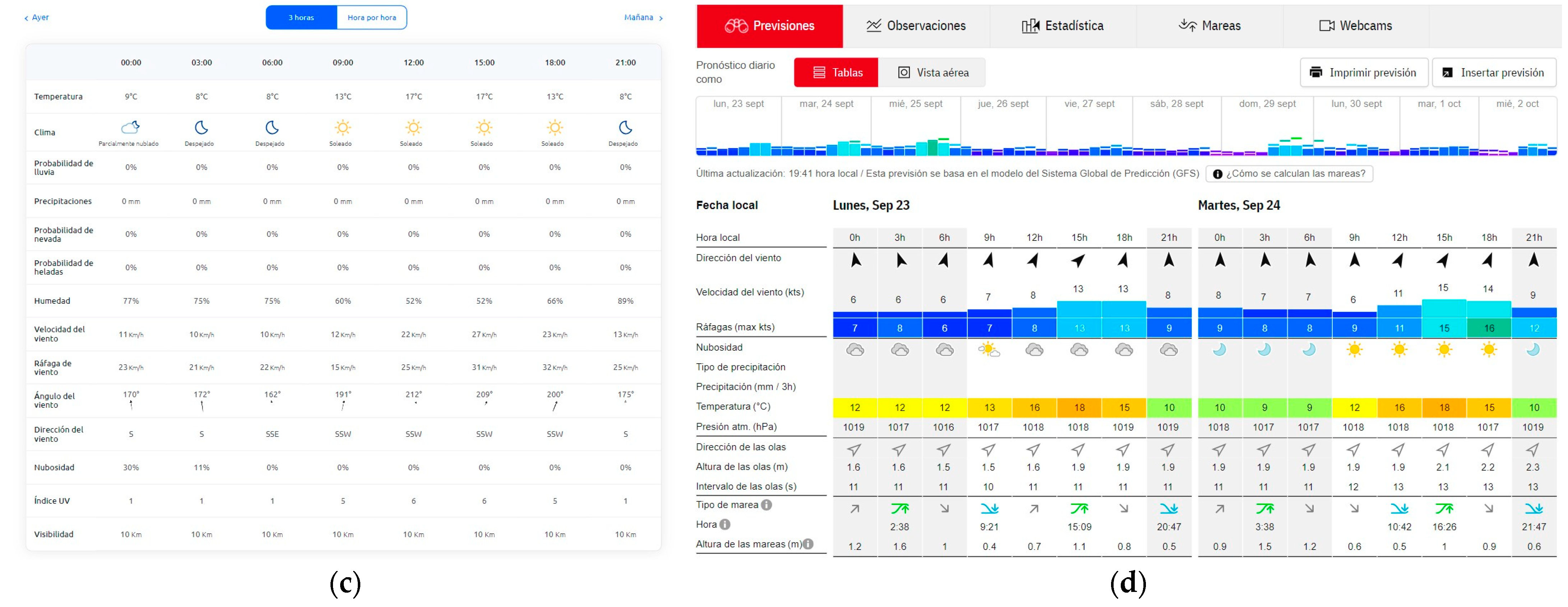
Weather information is typically available on websites, where it may be presented in a variety of formats to accommodate different user preferences and requirements. These formats typically include textual summaries (Figure 1a), such as forecasts and weather reports, which offer concise descriptions of current and future weather conditions. Visual representations (Figure 1b), such as weather maps and radar images, provide users with a graphical overview of temperature, precipitation, and other meteorological data. Additionally, numerical data tables (Figure 1c) offer precise figures for parameters like temperature, humidity, wind speed, and atmospheric pressure. Many weather websites also provide interactive features, such as dynamic graphs and charts (Figure 1d), allowing users to explore historical trends and patterns.

2.1.2. Hazardous Weather Alerts

Hazardous weather conditions can be detected through the analysis of weather information, in accordance with governmental regulations. This process involves a meticulous evaluation of meteorological data and climatic patterns, aligning with established guidelines and protocols. Once identified, hazardous weather alerts serve as a critical early-warning system, notifying individuals and authorities about imminent threats such as hurricanes, tornadoes, severe storms, flooding, wildfires, and extreme temperatures. They provide essential information that can help people take proactive measures to protect their lives and properties.
Examples of hazard alerts in the literature encompass a broad spectrum of weather-related phenomena. Some alerts do not depend significantly on the location. This is the case for the fire and wind hazards. Nevertheless, other weather conditions can significantly depend on this parameter. For example, coastal areas are more susceptible to hurricanes, storm surges, and coastal flooding, while regions prone to tectonic activity may face seismic hazards. In contrast, areas in the vicinity of forests or grasslands may be at risk of wildfires during dry seasons. Similarly, regions in colder climates may face challenges related to heavy snowfall and ice accumulation, while areas near rivers may be vulnerable to flooding. For instance, in recent years coastal settlements in the central area of Chile have been affected by extreme events such as swells [51]. This phenomenon is due to long-wavelength ocean waves generated by a combination of factors such as distant storms, atmospheric pressure changes, fetch, and wind speed and duration, with wind being the most predominant factor [52]. In the same area, in both coastal and offshore sectors, a sequence of large-scale wildfires have occurred, even requiring international assistance to mitigate their effects [53]. These events can be human-induced as well due to a combination of weather–environmental factors like drought, high temperatures, low humidity, winds, and the accumulation of dry vegetation [54].
It is in light of these location-specific considerations that the information embedded in the BIM model, encompassing topography and geographical characteristics, plays an important role in discerning the precise hazardous weather conditions that a structure may encounter.

2.1.3. Weather Information Extraction

While the versatility of formatting on weather websites offers users a wide array of options, it simultaneously introduces complexities when attempting to extract weather information. Noteworthy challenges in weather information extraction include the inconsistency in presenting weather data, making the development of a universal extraction algorithm a challenging task. Additionally, weather data undergo frequent updates, with varying update frequencies across different parameters, necessitating synchronization with each website’s update schedule. Another significant challenge arises from the constant updates and redesigns that weather websites undergo, potentially disrupting existing data extraction scripts. To address these complexities, developers often need to create customized web scraping scripts or data extraction tools tailored to each website’s unique format. It is important to note that the primary obstacle with these scripts lies in their intricate programming requirements, demanding advanced programming expertise even for small changes in the weather website. To address this challenge, the following section presents a more intuitive and user-friendly solution for automating the extraction of weather data from specialized websites through the use of an RPA protocol. Furthermore, this proposed protocol is also integrated into an automated BIM-based alarm system.
The use of web sources has been gaining relevance, as shown in the work of Karimiziarani et al. [55]. This research shows the use of the X social media [56] platform to provide a spatiotemporal analysis of the textual content from millions of tweets shared during Hurricane Harvey (2017) across several affected counties in southeast Texas. The study introduces a new Hazard Risk Awareness (HRA) Index that incorporates multiple factors, such as the volume of tweets, population data, internet usage rates, and the characteristics of natural hazards by geographic location. However, as this work also highlights, one of the main challenges is providing a real-time platform to prevent hazardous events based on these web sources.

2.2. From BIM Models to Digital Twins

Building Information Modeling (BIM) can be positioned in a central position in the digital transformation of the Architecture, Engineering, and Construction (AEC) industry and connects different information technologies working together throughout the whole infrastructure’s life cycle [57]. BIM is also considered to be related to DTs [58]. The concept of DTs has been described by the National Aeronautics and Space Administration (NASA) as “a comprehensive, multi-physics, multi-scale, probabilistic simulation of a vehicle or system that leverages state-of-the-art physical models, sensor data, fleet history, and more to replicate the entire lifespan of its airborne counterpart. This realistic simulation considers one or multiple critical and interconnected vehicle systems” [59]. Over time, the concept of DTs has been extended to different sectors, such as manufacturing [60,61], healthcare [62,63], aerospace and defense [64,65], energy [66,67], transportation [68,69], mining [70,71], smart cities [72,73], and environmental sciences. In this last application, DTs are used for simulating and monitoring ecosystems [74], weather patterns [75], and climate change [76]. The main output of these applications is related to understanding and mitigating environmental impacts [77].
A wide conception of DTs can be identified, encompassing a digital representation of a real-world system implemented through software or models mirroring a physical object, process, organization, person, or another abstraction [78]. Developing a DT imposes a set of requirements to achieve a complete result confirming the previous definitions of the DT. A main requirement of DT developing is achieving a fully integrated data flow between the physical and digital objects in both directions [79]. The seamless integration of processes results in an automated cycle, enabling interoperability with the physical system.
BIM models are foundational to the development of DTs. They provide a detailed digital blueprint that, when integrated with IoT and real-time data, evolves into a dynamic DT. This evolution enhances the value of the information model by extending its utility from the planning and construction phases into the entire lifecycle of the asset, including operation, maintenance, and eventual decommissioning.

2.3. RPA and Its Potential for the AEC Industry

Robotics has been widely adopted in the AEC industry, mainly during the construction process, providing solutions for autonomous construction, demolition, 3D printing, and tunneling, among others [80]. Other forms of robotics have been developed to interoperate with software user interfaces, and this has been called Robotic Process Automation (RPA) [81]. These robots do not have a tangible or physical form, but operate as an algorithm that emulates human actions in an application based on a workflow such as clicks, copying/pasting tables, and filling forms [82]. These tasks are orchestrated through a workflow containing different rules [83]. The application of RPA in the AEC industry is in its initial stages [84].
The existing works are related, for instance, to energy management systems in buildings [85] and integrating them into free- and open-source applications used in 3D models [86]. Considering that the AEC industry encompasses several processes (both in the field and in the management of the administrative activities that support the projects), the potential of RPA should be studied to identify the applications that could make these processes more efficient.
RPA may potentially face different challenges in the AEC industry. On the one hand, implementing a new technology requires a set of competencies, such as programming skills. Programming could be difficult considering the complexity of the process to be automated and the type of technology to be implemented, becoming a technical barrier. In this context, the concept of “citizen developers” has taken on relevancy when it is expected that a no skilled user is able to a build digital solution [87]. AEC professionals could be considered as citizen developers when a number of programming needs appear, for instance, by automating activities through Macros in Excel or Python-based solutions [88], and they have no strong coding skills [89]. In this regard, RPA appears as a user-friendly technology that can achieve the goal [90] of automating processes in a short period of time [91]. Using RPA, automation tasks could become easier and faster, particularly considering its user friendliness and interoperability with other applications. Moreover, RPA technology provides simple debugging tools that can make the achievement of automation faster [83].
On the other hand, when human activities in a civil project increase in volume (repetitions), these activities could become significantly time consuming. In this regard, emerging technologies—such as RPA—that support overcoming this issue are valued. For instance, monitoring the working of a system of sensors requires the observation of a dashboard of the systems’ performance. Then, by automating the tasks performed by humans (checking sensors’ performances, in this case), several man hours can be saved. Moreover, error reduction in automated activities has been one of the most valued features of automation [81]. One of the popular uses of RPA is document processing [90]. Project procurement processes are based on the need to analyze several types of documents, such as invoices. This activity could require more working hours (which translates into a higher cost) when the volume of documents increases. RPA allows for the automatic extraction of alfa-numerical data from invoices and can save them in data arrays or directly in Excel [90].

2.4. Weather Data with RPA

The proper storage and structuring of weather data are crucial for efficient capture and cleaning using the RPA protocol. To capture weather data effectively, it is essential to select reliable and reputable data sources. The RPA protocol should be configured to extract data at intervals that match the update frequency of the data source, ensuring that the information is both timely and relevant. Additionally, it is vital to ensure that the weather data accurately reflect the specific geographical area of interest.
When cleaning the captured data, handling missing or incomplete information is a primary concern. Techniques such as inteºrpolation can be employed to estimate missing values, while statistical methods help to identify and eliminate outliers. Formatting issues, including varying time zones and units of measurement, should be standardized within the RPA protocol to ensure consistency. To avoid redundancy, it is important to deduplicate records by maintaining unique identifiers for each data point. Normalization is also critical, involving the conversion of weather measurements into standardized units and the unification of categorical classifications across different sources.
For handling weather data over time, applying rolling averages can smooth out short-term fluctuations and provide more meaningful insights. Historical data should be managed carefully to account for potential biases introduced by changes in weather observation methods over time. Real-time validation techniques, such as cross-source verification, can help ensure the accuracy of the captured data, while sanity checks prevent the recording of unrealistic values.
In this research, data extracted from websites have been cleaned and formatted using the tools available in the RPA tool UiPath, such as [92] the data scrapping wizard for data structured in tables or lists, string manipulation activities (e.g., splitting through breaking down string based on specific delimiters like commas or spaces), and data table manipulation, filtering out unnecessary or invalid rows or columns based on certain conditions.
Finally, in web-based automation, one of the key activities is monitoring the architecture of websites. This is important because changes made by the website owner can disrupt the bot’s ability to extract and process data correctly. In such cases, the RPA tool sends an error message to the automation developer, notifying them that the bot needs to be updated to align with the website’s new architecture.

3. Automated BIM-Based Alarm System

3.1. Research Method

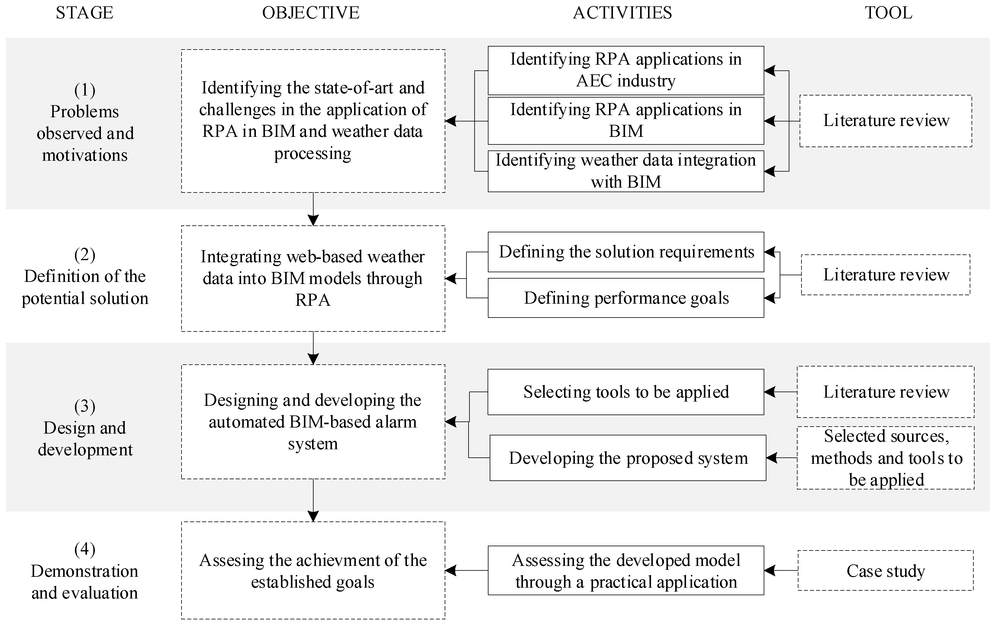
The research outlined in this work follows the Design Science Research Methodology (DSRM), which aims to develop an artifact that can solve a concrete problem within a particular context [93]. Figure 2 presents the DRSM adapted for this research addressing the aim of integrating web-based data into a BIM model with RPA composed of four stages, objectives, activities, and tools.
According to Figure 2, the first stage seeks to identify the current state-of-the-art and challenges associated with applying RPA within BIM and weather data processing. The primary activities in this stage involve exploring the applications of RPA in the AEC industry, identifying its specific uses in BIM processes, and investigating how weather data are integrated into BIM models. A literature review is employed as the main tool to gather insights on these topics, enabling the identification of gaps and challenges in current practices. This stage has been addressed in Section 2.
The second stage focuses on defining a solution to integrate web-based weather data into BIM models using RPA. This involves defining the specific requirements for the solution, such as the types of weather data to be integrated and the extent of automation needed within the BIM environment. Additionally, this stage includes formulating goals to achieve a proper RPA bot performance. A literature review is crucial to address this stage.
In the third stage, the objective is to design and develop an automated BIM-based alarm system capable of processing and incorporating weather data into BIM models through RPA. Key activities include selecting tools and software for developing the system, such as RPA platforms, BIM software, and weather data. The system is then developed, including the configuration and integration of the chosen RPA tool with the BIM model to automate weather data input. This stage also relies on using the literature to validate the selection of tools and methods, ensuring the system’s development is aligned with current industry standards and research. This stage is addressed further in Section 3.
Finally, the fourth stage addresses achieving the project’s established goals. This stage evaluates the functionality of the developed model through practical applications, typically by conducting a case study. In this case, the system is applied to a simulated project where weather data are integrated into a BIM model, and the results are analyzed. The case study method serves as a crucial tool for demonstrating the system’s effectiveness and assessing whether the integration of weather data enhances decision-making. This stage is covered in Section 4.

3.2. Developed Tool

In this section, we introduce an innovative methodology aimed at accomplishing the two following objectives: (1) automating the periodic integration and visualization of weather information, including hazardous conditions, into BIM digital twins, and (2) enabling the automatic delivery of alerts to stakeholders upon the detection of hazardous weather conditions.
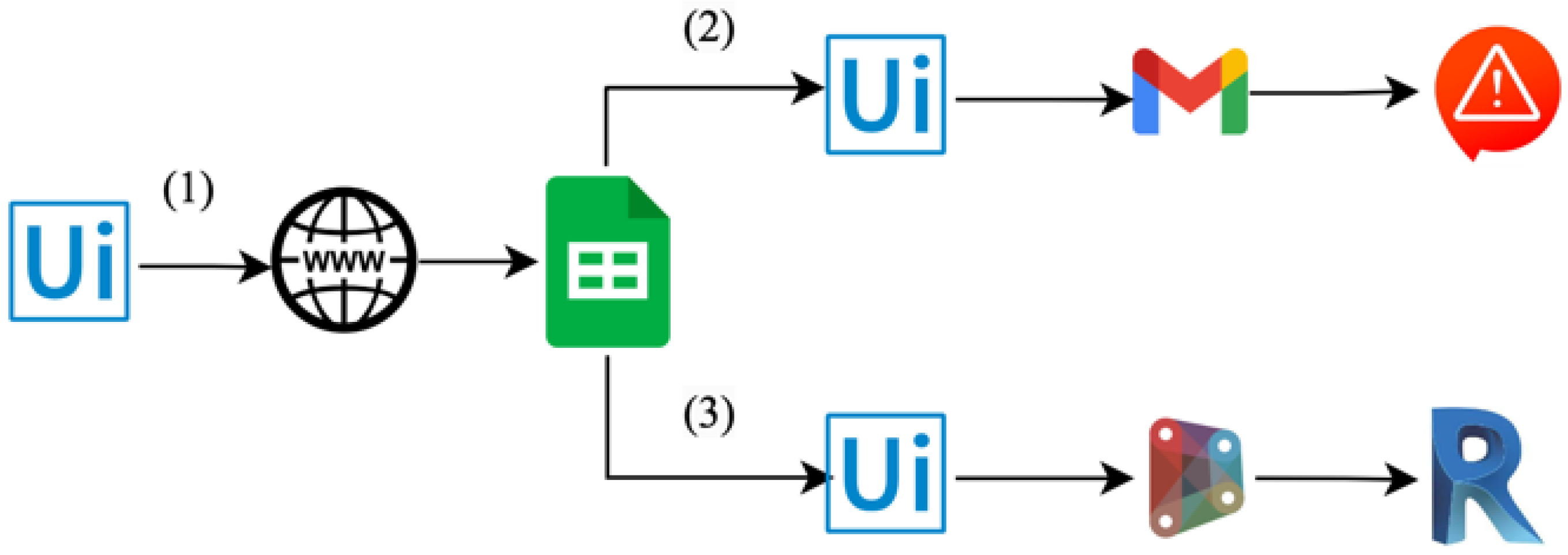
The proposed methodology is based on the four different RPA protocols defined in Figure 3. These protocols are as follows:
  • Weather information extraction: This RPA protocol is configured to periodically access the established weather websites and extract the weather data. Then, this information is organized and stored within an Excel spreadsheet located in the Google Drive cloud (Google Sheets). This sheet is programmed with the hazardous weather criteria to identify potential alerts. It is worth noting that the frequency with which the weather information is updated varies across different sites, necessitating distinct time-triggers within the RPA program;
  • Alert dispatch: In this step, the RPA protocol checks the weather analyses in Excel. In those cases where the predefined thresholds are surpassed, an RPA is programmed to transmit digital alerts to the stakeholders via email using Gmail;
  • Integration of weather data into the BIM model: This RPA protocol automates the introduction of the weather data collected in Step 1 into the BIM model;
  • Integration of BIM information into the weather database: This RPA protocol facilitates the export of BIM information that may be necessary for analyzing hazardous weather conditions to the Excel sheet containing the weather data.
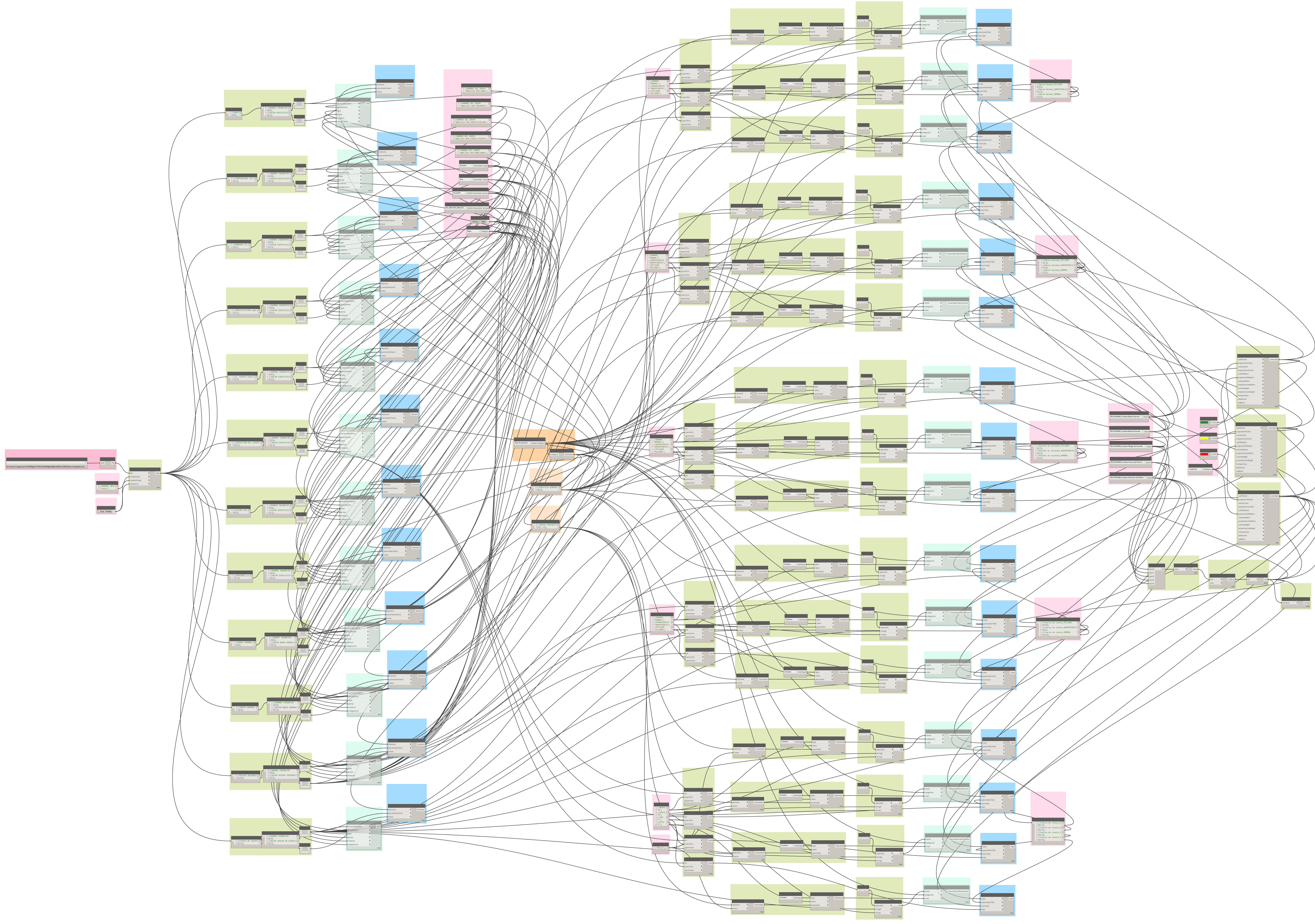
The RPA protocol depicted in Figure 3 employs Dynamo scripts to enable the exchange of information between the Excel sheet and the BIM software Revit. As an example, the fundamental components of the script used to import data into Revit is outlined in Figure 4, encompassing the following steps:
  • Access the Google Sheet containing the weather data and read the parameters, alerts along with their respective values/severity levels;
  • Create shared parameters for the weather data and incorporate their respective values/severity levels;
  • Create filters for the BIM mass model to depict the severity of the weather alerts and apply the data to different scenarios.

4. Case Study

In this section, the proposed methodology for automating the integration of weather data and the dispatch of alerts is applied to a real case study. Firstly, the geometry and the BIM model of the considered structure are described. Secondly, detailed information about the weather data introduced into the BIM model, sourced from weather websites, is provided. Additionally, the hazardous conditions studied are also reviewed. Finally, the proposed RPA is customized to the peculiarities of the case study, and the results obtained are subsequently presented.

4.1. Description of the Structure and BIM Model

The analyzed structure is a four-story residential building located in close proximity to the sea in Viña del Mar, Chile (red circle in Figure 5a). A digital twin of this structure was modeled using the Revit software, achieving a Level of Detail (LOD) of 350. This model, presented in Figure 5b, integrates data from various disciplines, including architecture, structural engineering, and mechanical, electrical, and plumbing (MEP) systems. In order to incorporate weather information and alerts into the BIM model, a representative mass of its envelope, depicted in Figure 5c, was created.

4.2. Weather Information Analysis

The weather information taken into account encompassed various factors, such as temperature, humidity, wind speed, wind direction, rainfall, tide, and wave data. These data were periodically extracted from Chilean weather forecast websites, namely [94,95], each of which updated their information at varying time intervals. Specific details regarding the frequency of updates for each of these weather parameters can be found in Table 1.
The selected weather websites employ various table formats to display their data. Tables presenting the environmental parameters like temperature, humidity, and wind speed, as well as tide and wave information, are depicted in Figure 6a, Figure 6b, and Figure 6c, respectively.
The weather alerts under consideration adhere to Chilean regulations and encompass the following: (1) alerts for fire hazards, determined by factors such as temperature, wind and humidity [96], (2) alerts for wind hazards, based on wind speed [97] and (3) alerts for swell conditions, dependent on wave direction, wave height, and wave period [98]. Table 2 [96,97] and Table 3 [98] provide an overview of these weather hazard alerts, offering insights into the three condition levels (normal, warning, and danger) addressed by these alert systems.
The Risk Index presented in Table 2 is calculated based on the Wildfire Index Risk provided in [96]. This approach for the project location (Viña del Mar) is based on the following equation:
Risk Index = 39.9622 − 0.6125 T − 0.7252 H + 0.7459 W + 25.7198 S,
where T is the current temperature (°C), H is the relative humidity (%), W is the wind speed (km/h), and S is a dimensionless seasonal factor which increases in summer and decreases in winter [96].

4.3. Robot Process Automation (RPA) Protocol

The RPA protocol was developed using the UiPath software [99]. This program has been employed in numerous applications in the literature (as seen in references [100] and [101]), and it was chosen due to the availability of a substantial portion of its functionalities in an unlimited trial mode. The developed code is presented in Figure 7a, and the flow of information is presented in Figure 7b. This protocol includes the following steps:
  • Weather information extraction: The RPA reads the weather information according to the predefined time triggers outlined in Table 1 and stores it within a Google Sheet hosted on a Google Drive account. This information encompasses various weather parameters, including temperature, humidity, rainfall, wind speed, wind direction, and wave height, along with their respective timestamps and update intervals. Additionally, it incorporates the studied weather hazards (fire, wind, and swell conditions) and the associated severity levels (normal, warning, or danger), as calculated from Table 2 and Table 3. A screenshot of the Google sheet used is presented in Figure 8;
  • Alert dispatch: In those cases where the predefined thresholds are surpassed, the RPA is programmed to transmit digital alerts to the stakeholders via Gmail;
  • Integration of weather data into the BIM model: The RPA lunches a Dynamo script to automate the introduction and representation of the weather data collected in Step 1 into the BIM model.
One iteration of the RPA protocol described in Figure 7 takes, on average, 1 min and 43 s. The same process performed manually could take a similar amount of time depending on the user’s expertise and familiarity with the websites. However, the main advantage of using RPA in this process is the possibility of the RPA bot working continuously 24/7. In this regard, if the process is performed manually, manual labor is required to access the selected websites, each hour, for instance, which would be impracticable.
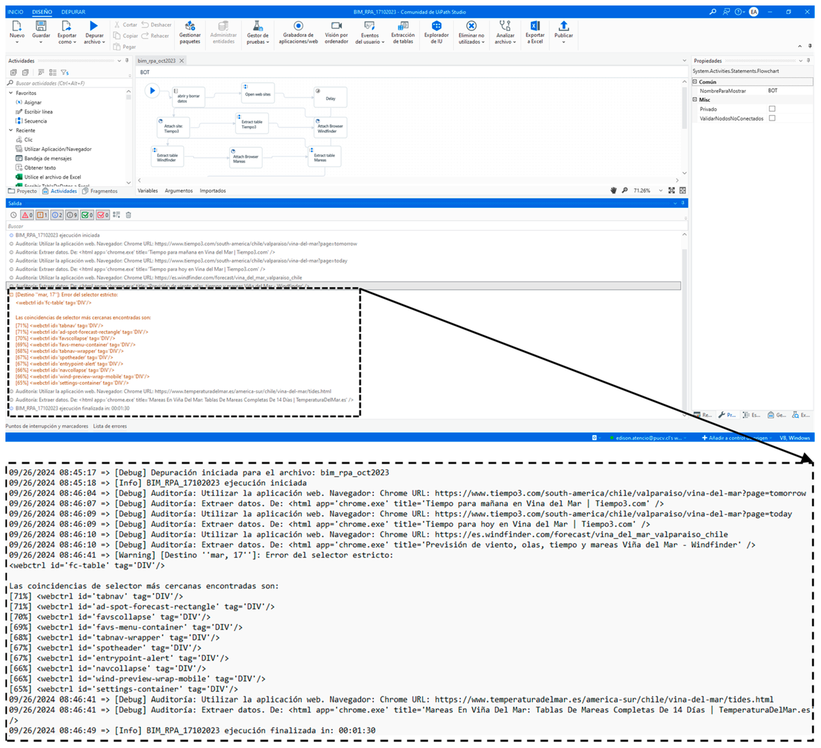
To assess the RPA bot’s performance, a key feature of the RPA tool (UiPath, in this research) is its ability to track each step of the automated process through detailed logs. As shown in Figure 8, UiPath’s output window displays a list of timestamps for each activity performed. These logs can be exported as a text file for further analysis. The highlighted section of Figure 8 shows an identified error that is recorded and can be reviewed to correct the code. Additionally, RPA tools can use these logs to generate more accurate alerts for users, such as detecting specific types of errors using regular expression (RegEx) pattern matching [102].
The quality of the data is controlled by the success of the process. If any automated process activities (described in Figure 9) are unsuccessful, the bot immediately reports the error to the users via email. This functionality could even be complemented with SMS messages sent to a group of phones to make this alert timelier.
A similar RPA-based solution has been proposed in [43]. In line with this research, the critical activity is the data gathering, and the possible errors come from the source (the sensor in the referenced paper or the websites in the present study) rather than the RPA software tool. In this regard, world-class RPA tools (like UiPath) provide a robust debugging system and a detailed description of errors to design a strategy to address them. Therefore, based on the error information available (and possibilities), the RPA bot sends a report to users.
The integration of the weather data with the BIM model step is based on the Dynamo script presented in Figure 10. This script includes the following steps:
  • Open the Google Sheet with the weather data and read the information provided for the weather parameters, alerts, and their respective values/severity levels;
  • Create a shared parameter for each of the parameters identified in Step 1, and associate them with their respective values/severity levels. This step also encompasses defining the parameter type;
  • Create filters to represent the severity levels of the analyzed hazards into defined views of the BIM mass model. Different colors are used for each of the severity levels (green for normal, yellow for warning, and red for danger). To illustrate the representation of wind direction, these filters consider the orientation of the model, displaying the wind’s impact solely on the affected façade.

4.4. Results

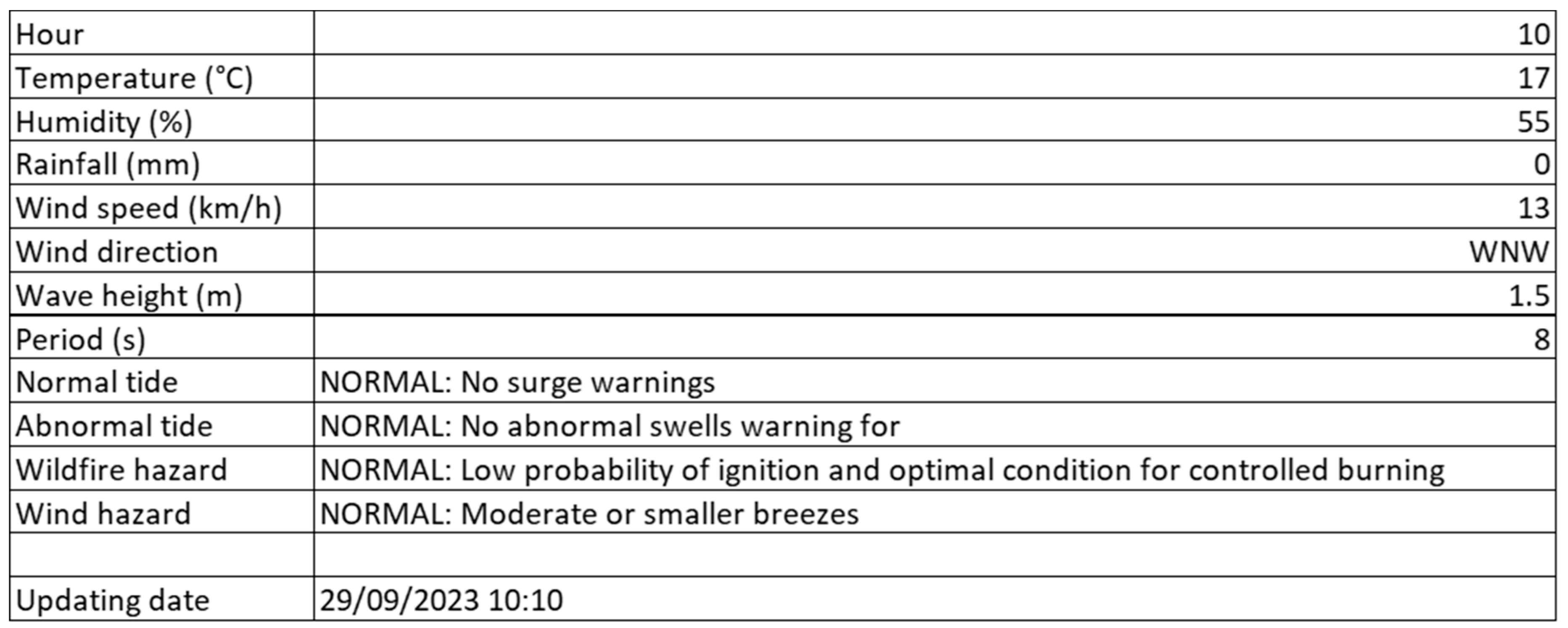
Figure 11 displays the properties of the BIM mass model. This table includes the weather parameters introduced into the BIM mass model accompanied by their respective values, as well as the weather hazards with their respective severity levels. In this particular case, all the analyzed hazards exhibited a normal severity level.
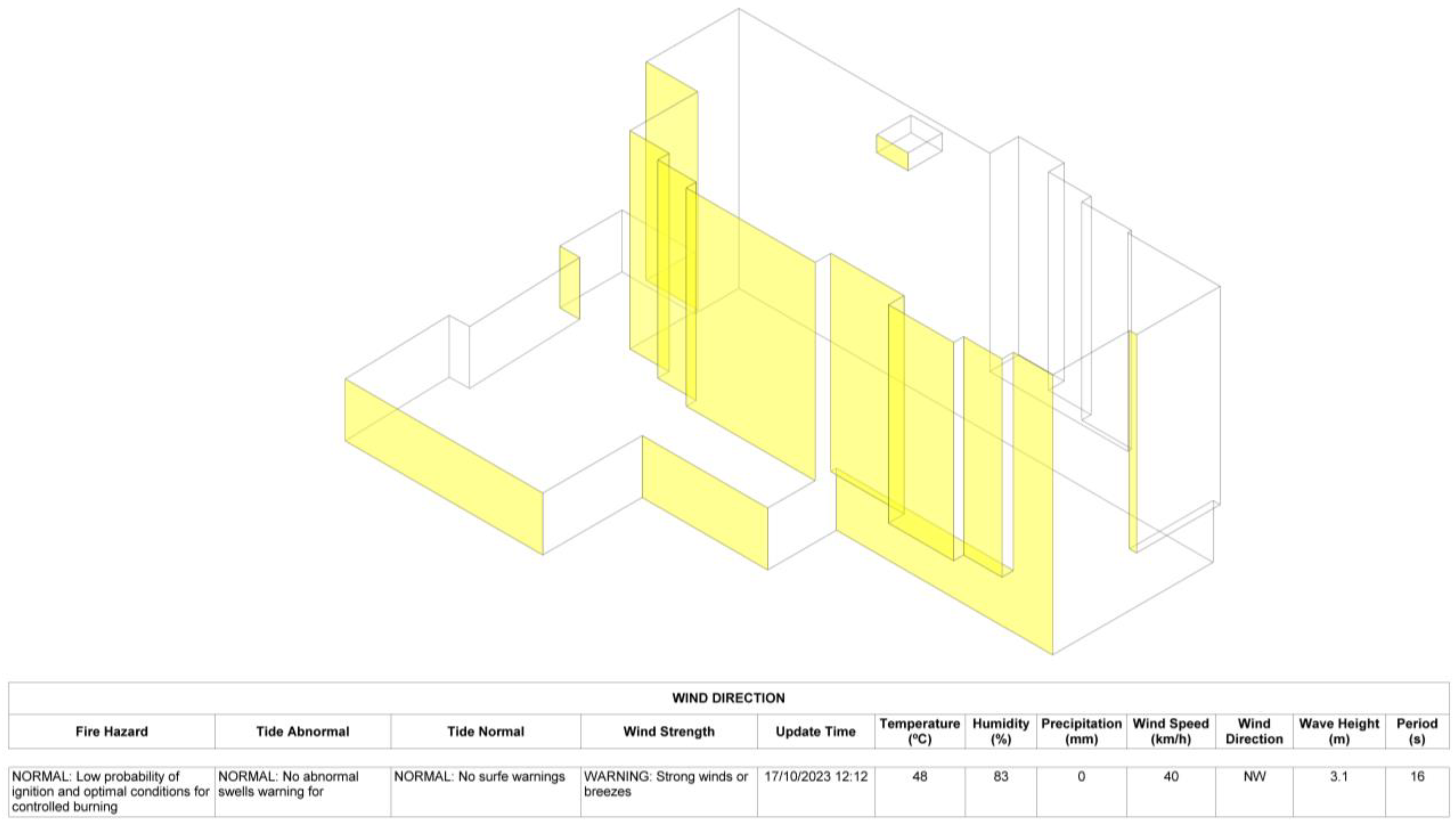
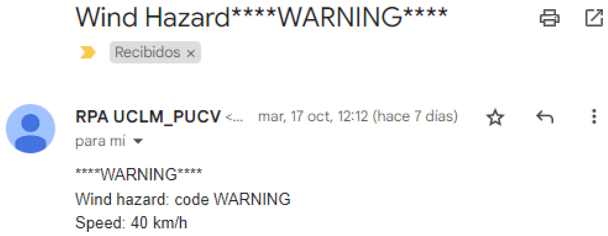
The representation of a warning severity level on the wind hazard is shown in Figure 12. In this scenario, the façade of the BIM mass model where the wind is impacting is highlighted in yellow. An illustration of an alert email sent by the RPA is depicted in Figure 13.
Figure 13 presents an example of the alert message that the application automatically sends when a wind hazard is detected. This message is delivered via email using Gmail services.
The practical implications of the tool developed for automating weather data extraction have a profound impact on the AEC industry. By providing consistent and timely weather data, the tool enhances the accuracy and promptness of forecasts, which is essential for effective project planning and scheduling. This enables construction managers to anticipate and address delays caused by adverse weather, thereby boosting overall project efficiency.
Furthermore, the tool’s real-time updates and early warnings improve risk management and site safety by facilitating proactive measures to safeguard workers and equipment. The efficiency gained from automating data collection translates into cost savings, reducing both labor expenses and delays that could otherwise lead to additional costs. Additionally, integrating the automated weather data with BIM supports real-time analysis and more informed decision-making. The tool’s ability to analyze historical data for trends also enhances long-term planning and predictive accuracy, aiding in future weather-related decision-making.

5. Discussion

With the escalating consequences of climate change, hazardous weather alerts assume a pivotal function as an early-warning mechanism, notifying stakeholders about impending dangers and consequently shaping decision-making within construction projects. Surprisingly, despite their evident value, alert systems for hazardous weather conditions are rarely integrated with BIM models of buildings. To fill this gap, this paper introduces a novel RPA-based protocol designed to automate the incorporation and visualization of scattered weather information into BIM model databases. Furthermore, this methodology facilitates the automatic delivery of electronic alerts when hazardous weather conditions are detected. The application of this methodology to a real building in Viña del Mar, Chile exemplified how RPA efficiently retrieves and stores weather information from various weather websites, each with different display formats and update frequencies, and automates its integration into a BIM database. Moreover, throughout the studied period, the RPA effectively delivered digital alerts for hazardous weather conditions via email when the normal severity levels were surpassed.
A key factor in the success of RPA implementation relates to the development of a well-defined sequence of activities. Then, an RPA bot can operate 24/7, avoiding human errors and achieving higher velocity levels, efficiency, and consistency. However, RPA bots should be monitored over time and maintained, considering that the applications with which the robot interacts may vary in terms of performance, and their interfaces could change. Therefore, since RPA bots are considered “virtual work,” this work should be supervised to achieve the expected performance.
RPA applications in the AEC industry are in their early stages, and the potential for harnessing their benefits is still a field to be explored. A main feature of RPA is its ease of application in terms of programming, making it possible for any professional with basic programming skills to implement it quickly. Another feature of RPA is the quick achievement of functional results. Since RPA automations are developed in a production environment, their results can be immediately perceived and evaluated. This allows for an agile type of project management, where minimum viable products (MVPs) are obtained in each stage of the automation process [103].

Future Research

In relation to future studies, the following avenues of research can be explored:
  • The exploration and evaluation of other processes in the AEC field to be automated. Every AEC enterprise comprises a set of business processes supporting the project development, such as procurement, invoice processing, payment, project reports, etc. When the project increases in complexity, these processes produce a large volume of transactions, requiring significant manual work. This complexity makes tasks susceptible to errors and creates bottlenecks due to a lack of operational capability. Therefore, there is a fertile field of research on the automation of AEC processes and achieving higher levels of efficiency. This research could also impact the current low productivity levels and digitalization of the AEC sector;
  • The integration of RPA and AI has the potential to revolutionize numerous aspects of the AEC industry. RPA enhances process automation by managing routine tasks such as invoicing, data extraction, and report generation. Meanwhile, AI adds substantial value by predicting trends and providing actionable insights derived from data analysis. Another significant application of these technologies is in predictive maintenance, where historical data are utilized to forecast equipment failures or maintenance needs, thereby reducing downtime and extending asset lifespans. AI-driven chatbots and virtual assistants further improve customer service by handling inquiries, offering real-time support, and enhancing overall customer experience. Additionally, these technologies excel in data analysis and visualization, processing large datasets to uncover patterns and generate reports that support informed decision-making;
  • In the specific context of weather forecasting, RPA and AI can markedly enhance both the accuracy and efficiency of data collection and analysis. RPA automates data collection by integrating weather information from various sources into a centralized system, thereby improving the quality and comprehensiveness of forecasts. AI algorithms, on the other hand, process real-time weather data to produce up-to-date predictions. Machine learning models continuously refine these forecasts based on new data, enhancing their accuracy. Furthermore, AI’s ability to analyze historical weather data reveals long-term trends and patterns, providing valuable insights into climate change and future weather scenarios. AI is also adept at detecting anomalies in weather patterns, such as unusual temperature fluctuations or extreme weather events, which enables timely warnings and improves project planning and scheduling;
  • RPA tools, such as UiPath, which is applied in this research, have recently integrated more advanced AI capabilities into their platforms, enhancing the ability of businesses to automate complex tasks that require cognitive skills [104]. Integrating AI-driven models, such as natural language processing (NLP), computer vision, and machine learning, allows RPA bots to understand unstructured data, process documents intelligently, and make data-driven decisions in real time. These advancements are a step toward building hyper-automation solutions, where AI, alongside RPA, facilitates end-to-end automation processes, improving efficiency, accuracy, and scalability across industries [105];
  • RPA technology allows users to perform automatic activities through the development of several bots working in coordination and supervised by other bots. Since processes should operate interrelatedly, RPA processes should also work through an orchestrated operation. This type of RPA use is known as RPA orchestration, and there is no evidence in the literature of studies related to the AEC field, opening new research avenues;
  • Emerging technologies require new capabilities to implement and manage them over time. The current knowledge about RPA lacks a discussion of how this technology should be installed sustainably in the AEC sector, considering its particularities in terms of activities. Similarly other industries that are more mature in their use of this technology, RPA’s roles should be defined with a robust knowledge of the technology and AEC-related processes. Future research could develop a framework to implement and manage RPA technology in the sector. This research could use the BIM technology and BIM roles framework as a reference. Moreover, the interoperability of RPA with AEC-related technologies must be considered.
Finally, the proposed application aims to inspire researchers and practitioners to incorporate the emerging RPA technology into their future civil engineering applications.

6. Conclusions

This work proposes a novel framework for automating the extraction, integration, and visualization of real-time weather data within digital twins, setting a new standard for environmental data-driven decision-making in construction management. Specifically, this study underscores the importance of integrating hazardous weather alerts into construction project decision-making, especially in the face of escalating climate change. Despite the value of timely weather information, such systems have been largely absent from BIM. To address this gap, an RPA-based protocol that automates the integration and visualization of weather data within BIM models is developed and validated in a real scenario. This approach not only streamlines the retrieval and processing of diverse weather data but also ensures timely digital alerts for hazardous conditions. The developed methodology also underscores the flexibility of BIM when integrated with other digital technologies, like RPA and parametric programming, showing the interoperability required for a seamless flow of information.
By automating the extraction of weather data from multiple web-based sources and integrating it into BIM models, the study provides a practical tool for real-time hazard management, significantly reducing the manual effort required to monitor and update weather conditions. This not only increases operational efficiency but also mitigates the risk of human error—crucial in high-stakes environments where timely and accurate decision-making can prevent costly delays and improve safety outcomes.
This research presents several limitations which represents challenges to be addressed in future research, such as:
  • Dependency on external data sources: The RPA’s effectiveness relies heavily on the availability and accuracy of weather data from external websites. Changes in the data source’s structure, such as updates to website layout or data format, could disrupt the extraction process and require adjustments to the RPA. To address this issue, the use of in situ sensors should be studied in future works;
  • Software: The proposed application is currently restricted to Autodesk software, specifically Dynamo and Revit. To extend functionality to other BIM programs, a thorough examination of interoperability between different software platforms is necessary. This would involve revising both the parametric programming algorithms and the RPA protocol to accommodate diverse BIM environments;
  • Scalability and adaptability: The application of the proposed methodology may face challenges when applied to different geographic locations or scales. Variations in local weather data sources, reporting standards, or project requirements could necessitate modifications to the RPA protocol to maintain functionality and accuracy;
  • Maintenance and monitoring: Ongoing maintenance is crucial to ensure that the RPA performs effectively. This includes monitoring for updates or changes in the external websites, adjusting the protocol to handle new data formats, and ensuring compatibility with evolving versions of Dynamo and Revit.
Finally, the study highlights the vast potential of RPA in the AEC industry, pointing to future opportunities to automate additional processes, integrate AI, and develop comprehensive RPA frameworks. This research aims to inspire a broader adoption of RPA technology in civil engineering, driving innovation and enhanced efficiency in the sector.

Author Contributions

Conceptualization, J.A.L.-G., E.A., F.M.-L.R. and F.L.; methodology, J.A.L.-G., E.A., and F.M.-L.R.; software, I.A., E.A. and F.L.; validation, J.A.L.-G., E.A., and F.M.-L.R.; formal analysis, J.A.L.-G., E.A., F.M.-L.R. and F.L.; investigation, F.L. and I.A.; resources, F.L. and I.A.; writing—original draft preparation, F.L.; writing—review and editing, J.A.L.-G., E.A., I.A. and F.M.-L.R.; visualization, F.L., I.A. and E.A.; supervision, J.A.L.-G., E.A. and F.M.-L.R.; funding acquisition, J.A.L.-G. All authors have read and agreed to the published version of the manuscript.

Funding

This research was funded by FEDER, grant number PID2021-126405OB-C31 and PID2021-126405OB-C32 funded by FEDER funds—A Way to Make Europe and Spanish Ministry of Economy and Competitiveness MICIN/AEI/10.13039/501100011033/.

Institutional Review Board Statement

Not applicable.

Informed Consent Statement

Not applicable.

Data Availability Statement

The dataset is available on request from the corresponding author.

Acknowledgments

The authors would like to thank all participants for their cooperation and participation in this study.

Conflicts of Interest

The authors declare no conflicts of interest. The funders had no role in the design of the study; in the collection, analyses, or interpretation of data; in the writing of the manuscript; or in the decision to publish the results.

References

  1. Pereiro, X.; Cabaleiro, M.; Conde, B. BIM Methodology for Cost Analysis, Sustainability, and Management of Steel Structures with Reconfigurable Joints for Industrial Structures. J. Build. Eng. 2023, 77, 107443. [Google Scholar] [CrossRef]
  2. Wang, Y.; Zhuang, J.; Zhou, G.; Wang, S. Research on Unbalanced Mining of Highway Project Key Data Based on Knowledge Graph and Cloud Model. Alex. Eng. J. 2023, 68, 67–81. [Google Scholar] [CrossRef]
  3. Amer, M.; Naaman, A.; M’Sirdi, N.K.; El-Zonkoly, A.M. Smart Home Energy Management Systems Survey. In Proceedings of the International Conference on Renewable Energies for Developing Countries 2014, Beirut, Lebanon, 26–27 November 2014; pp. 167–173. [Google Scholar] [CrossRef]
  4. Caglayan, S.; Ozorhon, B. Automation in Construction Determining Building Information Modeling Effectiveness. Autom. Constr. 2023, 151, 104861. [Google Scholar] [CrossRef]
  5. Opoku, D.J.; Perera, S.; Osei-kyei, R.; Rashidi, M. Digital Twin Application in the Construction Industry: A Literature Review. J. Build. Eng. 2021, 40, 102726. [Google Scholar] [CrossRef]
  6. Zhang, T.; Tien, D.; Kang, J. Application of Building Information Modeling-Blockchain Integration in the Architecture, Engineering, and Construction/Facilities Management Industry: A Review. J. Build. Eng. 2023, 77, 107551. [Google Scholar] [CrossRef]
  7. Tuhaise, V.V.; Handibry, J.; Tah, M.; Abanda, F.H. Automation in Construction Technologies for Digital Twin Applications in Construction. Autom. Constr. 2023, 152, 104931. [Google Scholar] [CrossRef]
  8. Hadjidemetriou, L.; Stylianidis, N.; Englezos, D.; Papadopoulos, P.; Eliades, D.; Timotheou, S.; Polycarpou, M.M.; Panayiotou, C. A Digital Twin Architecture for Real-Time and Offline High Granularity Analysis in Smart Buildings. Sustain. Cities Soc. 2023, 98, 104795. [Google Scholar] [CrossRef]
  9. Amin, A.; Ansari, R.; Taherkhani, R.; Hosseini, M.R. Developing a Novel Cash Flow Risk Analysis Framework for Construction Projects Based on 5D BIM. J. Build. Eng. 2021, 44, 103341. [Google Scholar] [CrossRef]
  10. Lozano, F. Automatic Calibration and Sustainability Assessment of BIM Digital Twins with Smart Low-Cost Sensors Information. Ph.D. Dissertation, Universidad de Castilla-La Mancha, Ciudad Real, Castilla-La Mancha, Spain, 23 May 2024. [Google Scholar]
  11. Zaalouk, A.; Moon, S.; Han, S. Automation in Construction Operations Planning and Scheduling in Off-Site Construction Supply Chain Management: Scope Definition and Future Directions. Autom. Constr. 2023, 153, 104952. [Google Scholar] [CrossRef]
  12. Lim, Y.W.; Chong, H.Y.; Ling, P.C.H.; Tan, C.S. Greening Existing Buildings through Building Information Modelling: A Review of the Recent Development. Build. Environ. 2021, 200, 107924. [Google Scholar] [CrossRef]
  13. Soust-verdaguer, B.; Galeana, I.B.; Llatas, C.; Montes, M. V How to Conduct Consistent Environmental, Economic, and Social Assessment during the Building Design Process. A BIM-Based Life Cycle Sustainability Assessment Method. J. Build. Eng. 2022, 45, 103516. [Google Scholar] [CrossRef]
  14. Zheng, L.; Lu, W.; Wu, L.; Zhou, Q. A Review of Integration between BIM and CFD for Building Outdoor Environment Simulation. Build. Environ. 2023, 228, 109862. [Google Scholar] [CrossRef]
  15. Lozano-Galant, J.A.; Turmo, J. Traffic Road Emission Estimation Through Visual Programming Algorithms and Building Information Models: A Case Study. IEEE Access 2021, 9, 150846–150864. [Google Scholar] [CrossRef]
  16. Zhang, S.; Sulankivi, K.; Kiviniemi, M.; Romo, I.; Eastman, C.M.; Teizer, J. BIM-Based Fall Hazard Identification and Prevention in Construction Safety Planning. Saf. Sci. 2015, 72, 31–45. [Google Scholar] [CrossRef]
  17. Xu, F.; Liu, Q. Building Energy Consumption Optimization Method Based on Convolutional Neural Network and BIM. Alex. Eng. J. 2023, 77, 407–417. [Google Scholar] [CrossRef]
  18. Sabah Haseeb, Q.; Muhammed Yunus, S.; Attellah Ali Shoshan, A.; Ibrahim Aziz, A. A Study of the Optimal Form and Orientation for More Energy Efficiency to Mass Model Multi-Storey Buildings of Kirkuk City, Iraq. Alex. Eng. J. 2023, 71, 731–741. [Google Scholar] [CrossRef]
  19. Weather.Com. Available online: https://weather.com/weather/today/l/4494c890282e298d87b54d1ea711a4a05e54af783093a426fe8a4bfce11c306b98df80728f406b3a773c3bd6afebff2b (accessed on 18 September 2023).
  20. AccuWeather. Available online: https://www.accuweather.com/es/es/barcelona/307297/weather-forecast/307297 (accessed on 28 September 2023).
  21. Diz-Mellado, E.; López-Cabeza, V.P.; Rivera-Gómez, C.; Galán-Marín, C. Seasonal Analysis of Thermal Comfort in Mediterranean Social Courtyards: A Comparative Study. J. Build. Eng. 2023, 78, 107756. [Google Scholar] [CrossRef]
  22. Xiong, F.; Wen, H.; Zhang, C.; Song, C.; Zhou, X. Semantic Segmentation Recognition Model for Tornado-Induced Building Damage Based on Satellite Images. J. Build. Eng. 2022, 61, 105321. [Google Scholar] [CrossRef]
  23. BBC Chile Forest Fires: More Than 100 Dead in Valparaíso Region. Available online: https://www.bbc.com/news/world-latin-america-68196048 (accessed on 12 February 2024).
  24. Shirowzhan, S.; Sepasgozar, S.M.E.; Edwards, D.J.; Li, H.; Wang, C. Automation in Construction BIM Compatibility and Its Differentiation with Interoperability Challenges as an Innovation Factor. Autom. Constr. 2020, 112, 103086. [Google Scholar] [CrossRef]
  25. State, P. Penn State BIM Uses. Available online: https://bim.psu.edu/uses/ (accessed on 7 October 2022).
  26. Ceranic, B.; Beardmore, J.; Cox, A. Rapid Deployment Modular Building Solutions and Climatic Adaptability: Case Based Study of a Novel Approach to “Thermal Capacity on Demand”. Energy Build. 2018, 167, 124–135. [Google Scholar] [CrossRef]
  27. Larsen, K.E.; Lattke, F.; Ott, S.; Winter, S. Surveying and Digital Workflow in Energy Performance Retrofit Projects Using Prefabricated Elements. Autom. Constr. 2011, 20, 999–1011. [Google Scholar] [CrossRef]
  28. Hou, F.; Ma, J.; Kwok, H.H.L.; Cheng, J.C.P. Prediction and Optimization of Thermal Comfort, IAQ and Energy Consumption of Typical Air-Conditioned Rooms Based on a Hybrid Prediction Model. Build. Environ. 2022, 225, 109576. [Google Scholar] [CrossRef]
  29. Rashidian, S.; Drogemuller, R.; Omrani, S. Compatibility of Existing Bim Maturity Models With Lean Construction and Integrated Project Delivery. J. Inf. Technol. Constr. 2022, 27, 496–511. [Google Scholar] [CrossRef]
  30. Autodesk Energy Performance and Climate in BIM. Available online: https://www.autodesk.com/support/technical/article/caas/tsarticles/ts/1jpr14GEK6qUEyQgPzhIdr.html (accessed on 9 October 2023).
  31. Mobaraki, B.; Lozano-Galant, F.; Soriano, R.P.; Castilla Pascual, F.J. Application of Low-Cost Sensors for Building Monitoring: A Systematic Literature Review. Buildings 2021, 11, 336. [Google Scholar] [CrossRef]
  32. Zahid, H.; Elmansoury, O.; Yaagoubi, R. Dynamic Predicted Mean Vote: An IoT-BIM Integrated Approach for Indoor Thermal Comfort Optimization. Autom. Constr. 2021, 129, 103805. [Google Scholar] [CrossRef]
  33. Birgonul, Z. A Receptive-Responsive Tool for Customizing Occupant’s Thermal Comfort and Maximizing Energy Efficiency by Blending BIM Data with Real-Time Information. Smart Sustain. Built Environ. 2021, 10, 504–535. [Google Scholar] [CrossRef]
  34. Shaharuddin, S.; Abdul Maulud, K.N.; Syed Abdul Rahman, S.A.F.; Che Ani, A.I.; Pradhan, B. The Role of IoT Sensor in Smart Building Context for Indoor Fire Hazard Scenario: A Systematic Review of Interdisciplinary Articles. Internet Things 2023, 22, 100803. [Google Scholar] [CrossRef]
  35. Collao, J.; Lozano-galant, F.; Lozano-galant, J.A. BIM Visual Programming Tools Applications in Infrastructure Projects: A State-of-the-Art Review. Appl. Sci. 2021, 11, 8343. [Google Scholar] [CrossRef]
  36. Korus, K.; Salamak, M. Optimization of Geometric Parameters of Arch Bridges Using Visual Programming FEM Components and Genetic Algorithm. Eng. Struct. J. 2021, 241, 112465. [Google Scholar] [CrossRef]
  37. Atencio, E.; Araya, P.; Oyarce, F.; Herrera, R.F.; Rivera, F.M.; Lozano-galant, F. Towards the Integration and Automation of the Design Process for Domestic Drinking-Water and Sewerage Systems with BIM. Appl. Sci. 2022, 12, 9063. [Google Scholar] [CrossRef]
  38. Demirdöğen, G.; Işık, Z.; Arayici, Y. BIM-Based Big Data Analytic System for Healthcare Facility Management. J. Build. Eng. 2023, 64, 105713. [Google Scholar] [CrossRef]
  39. Integration of Environmental Sensors with BIM: Case Studies Using Arduino, Dynamo, and the Revit API. Available online: https://informesdelaconstruccion.revistas.csic.es/index.php/informesdelaconstruccion/article/view/3575/4027 (accessed on 28 September 2023).
  40. Liu, Y.; Li, M.; Wong, B.C.L.; Chan, C.M.; Cheng, J.C.P.; Gan, V.J.L. BIM-BVBS Integration with OpenBIM Standards for Automatic Prefabrication of Steel Reinforcement. Autom. Constr. 2021, 125, 103654. [Google Scholar] [CrossRef]
  41. Asatiani, A.; Penttinen, E. Turning Robotic Process Automation into Commercial Success—Case OpusCapita. J. Inf. Technol. Teach. Cases 2016, 6, 67–74. [Google Scholar] [CrossRef]
  42. Ng, K.K.H.; Chen, C.H.; Lee, C.K.M.; Jiao, J.; Yang, Z.X. A Systematic Literature Review on Intelligent Automation: Aligning Concepts from Theory, Practice, and Future Perspectives. Adv. Eng. Inform. 2021, 47, 101246. [Google Scholar] [CrossRef]
  43. Atencio, E.; Komarizadehasl, S.; Lozano-Galant, J.A.; Aguilera, M. Using RPA for Performance Monitoring of Dynamic SHM Applications. Buildings 2022, 12, 1140. [Google Scholar] [CrossRef]
  44. Jiang, H.; Ling, R. Using RPA+BIM for High Efficient Operation of Smart Building’s Equipment Room. Preprint 2022, 2022100045. [Google Scholar] [CrossRef]
  45. Syed, R.; Suriadi, S.; Adams, M.; Bandara, W.; Leemans, S.J.J.; Ouyang, C.; ter Hofstede, A.H.M.; van de Weerd, I.; Wynn, M.T.; Reijers, H.A. Robotic Process Automation: Contemporary Themes and Challenges. Comput. Ind. 2020, 115, 103162. [Google Scholar] [CrossRef]
  46. Karn, S.; Kotecha, R. RPA-Based Implementation of IoT. SSRN Electron. J. 2021. [Google Scholar] [CrossRef]
  47. Spark, W. Climate and Average Weather Year Round in Viña Del Mar. Available online: https://weatherspark.com/y/25809/Average-Weather-in-Viña-del-Mar-Chile-Year-Round (accessed on 24 October 2023).
  48. Channel, T.W. Viña Del Mar Weather. Available online: https://weather.com/en-MT/weather/radar/interactive/l/6e23b2ba9a8b4e1124f4a09b2c1b01dc6a9e265569a816f505a0300fe40641a9 (accessed on 24 October 2023).
  49. Tiempo3 Pronóstico Del Tiempo Viña Del Mar. Available online: https://www.tiempo3.com/south-america/chile/valparaiso/vina-del-mar?page=today (accessed on 24 October 2023).
  50. Windfinder. Windfinder Weather Data. Available online: https://es.windfinder.com/forecast/vina_del_mar_valparaiso_chile (accessed on 24 October 2023).
  51. Winckler, P.; Contreras-López, M.; Garreaud, R.; Meza, F. Analysis of Climate-Related Risks for Chile ’ s Coastal Settlements in the ARClim Web Platform. Water 2022, 14, 3594. [Google Scholar] [CrossRef]
  52. Winckler, P. Nuevas Metodologías Para El Estudio de Marejadas En Chile. In La Zona Costera en Chile: Adaptación y Planificación para la Resiliencia; Martínez, C., Hidalgo, R., Henríquez, C., Arenas, F., Rangel-Buitrago, N., Contreras-López, M., Eds.; CIGIDEN: Santiago de Chile, Chile, 2019; pp. 51–78. ISBN 9789561424425. [Google Scholar]
  53. NOAA. NOAA Satellites Track Blazing Wildfires in Chile. Available online: https://www.nesdis.noaa.gov/news/noaa-satellites-track-blazing-wildfires-chile (accessed on 10 October 2023).
  54. Zacharakis, I.; Tsihrintzis, V.A. Integrated Wildfire Danger Models and Factors: A Review. Sci. Total Environ. 2023, 899, 165704. [Google Scholar] [CrossRef]
  55. Karimiziarani, M.; Jafarzadegan, K.; Abbaszadeh, P.; Shao, W.; Moradkhani, H. Hazard Risk Awareness and Disaster Management: Extracting the Information Content of Twitter Data. Sustain. Cities Soc. 2022, 77, 103577. [Google Scholar] [CrossRef]
  56. X X: Happening Now. Available online: https://twitter.com/?lang=es (accessed on 12 February 2024).
  57. Atencio, E.; Muñoz-La Rivera, F.; Mancini, M.; Bustos, G. Towards the Integration Between Construction Projects and the Organization: The Connections Between BIM and Enterprise Architecture. In Complexity and Sustainability in Megaprojects—MerIT; Favari, E., Cartoni, F., Eds.; Springer: Cham, Switzerland; Milan, Italy, 2022; pp. 161–176. [Google Scholar] [CrossRef]
  58. Xia, H.; Liu, Z.; Efremochkina, M.; Liu, X.; Lin, C. Study on City Digital Twin Technologies for Sustainable Smart City Design: A Review and Bibliometric Analysis of Geographic Information System and Building Information Modeling Integration. Sustain. Cities Soc. 2022, 84, 104009. [Google Scholar] [CrossRef]
  59. Shafto, M.; Conroy, M.; Rich, D.; Glaessgen, E.; Kemp, C.; LeMougne, J.; Wang, L. DRAFT Modeling, Simulation, Information Technology & Processing Roadmap; NASA, Ed.; NASA: Washington, DC, USA, 2010. [Google Scholar]
  60. Wei, Y.; Hu, T.; Dong, L.; Ma, S. Digital Twin-Driven Manufacturing Equipment Development. Robot. Comput. Integr. Manuf. 2023, 83, 102557. [Google Scholar] [CrossRef]
  61. Zhang, J.; Cui, H.; Yang, A.L.; Gu, F.; Shi, C.; Zhang, W.; Niu, S. An Intelligent Digital Twin System for Paper Manufacturing in the Paper Industry. Expert Syst. Appl. 2023, 230, 120614. [Google Scholar] [CrossRef]
  62. Mukherjee, P.P.; Afroj, M.; Hossain, S.; Biswas, M. Towards a Digital Twin Integrated DLT and IoT-Based Automated Healthcare Ecosystem. In Recent Trends in Image Processing and Pattern Recognition. RTIP2R 2022; Communications in Computer and Information Science Series; Springer: Cham, Switzerland, 2023; Volume 1704, pp. 311–323. [Google Scholar] [CrossRef]
  63. Pesantez, J.E.; Alghamdi, F.; Sabu, S.; Mahinthakumar, G.; Berglund, E.Z. Using a Digital Twin to Explore Water Infrastructure Impacts during the COVID-19 Pandemic. Sustain. Cities Soc. 2022, 77, 103520. [Google Scholar] [CrossRef]
  64. Li, Y.; Liu, W.; Zhang, Y.; Zhang, W.; Gao, C.; Chen, Q.; Ji, Y. Interactive Real-Time Monitoring and Information Traceability for Complex Aircraft Assembly Field Based on Digital Twin. IEEE Trans. Ind. Inform. 2023, 19, 9745–9756. [Google Scholar] [CrossRef]
  65. Wang, F.; Gan, T.; Wang, Y.; Jin, J. Key Technology of Digital Twin System for Aero-Engine Combustors. Hangkong Dongli Xuebao/J. Aerosp. Power 2023, 38, 776–790. [Google Scholar] [CrossRef]
  66. Vaccari, M.; Pannocchia, G.; Tognotti, L.; Paci, M. Rigorous Simulation of Geothermal Power Plants to Evaluate Environmental Performance of Alternative Configurations. Renew. Energy 2023, 207, 471–483. [Google Scholar] [CrossRef]
  67. Sifat, M.M.H.; Choudhury, S.M.; Das, S.K.; Ahamed, M.H.; Muyeen, S.M.; Hasan, M.M.; Ali, M.F.; Tasneem, Z.; Islam, M.M.; Islam, M.R.; et al. Towards Electric Digital Twin Grid: Technology and Framework Review. Energy AI 2023, 11, 100213. [Google Scholar] [CrossRef]
  68. Smeets, J.; Öztürk, K.; Liebich, R. Digital Twins for Automotive Development: Two Wheelers Application. Adv. Eng. Inform. 2023, 56, 101982. [Google Scholar] [CrossRef]
  69. Li, Y.; Zhang, W. Traffic Flow Digital Twin Generation for Highway Scenario Based on Radar-Camera Paired Fusion. Sci. Rep. 2023, 13, 642. [Google Scholar] [CrossRef]
  70. Cacciuttolo, C.; Guzmán, V.; Catriñir, P.; Atencio, E.; Komarizadehasl, S.; Lozano-Galant, J.A. Low-Cost Sensors Technologies for Monitoring Sustainability and Safety Issues in Mining Activities: Advances, Gaps, and Future Directions in the Digitalization for Smart Mining. Sensors 2023, 23, 6846. [Google Scholar] [CrossRef] [PubMed]
  71. Elbazi, N.; Tigami, A.; Laayati, O.; El Maghraoui, A.; Chebak, A.; Mabrouki, M. Digital Twin-Enabled Monitoring of Mining Haul Trucks with Expert System Integration: A Case Study in an Experimental Open-Pit Mine. In Proceedings of the 2023 5th Global Power, Energy and Communication Conference (GPECOM), Nevsehir, Turkiye, 14–16 June 2023; Institute of Electrical and Electronics Engineers Inc.: Piscataway, NJ, USA, 2023; pp. 168–174, ISBN 979-8-3503-0199-1. [Google Scholar]
  72. Weil, C.; Bibri, S.E.; Longchamp, R.; Golay, F.; Alahi, A. Urban Digital Twin Challenges: A Systematic Review and Perspectives for Sustainable Smart Cities. Sustain. Cities Soc. 2023, 99, 104862. [Google Scholar] [CrossRef]
  73. Muñoz La Rivera, F.; Atencio, E.; Mora-Serrano, J. Extended Reality (XR) as an Interaction Tool for Digital Twins: Application to Safety Management in Construction Megaprojects. In International Workshop on A Multidisciplinary Approach to Embrace Complexity and Sustainability in Megaprojects, MERIT 2022; Favari, E., Cantoni, F., Eds.; Springer: Milan, Italy, 2022. [Google Scholar] [CrossRef]
  74. Zhong, C.; Cheng, S.; Kasoar, M.; Arcucci, R. Reduced-Order Digital Twin and Latent Data Assimilation for Global Wildfire Prediction. Nat. Hazards Earth Syst. Sci. 2023, 23, 1755–1768. [Google Scholar] [CrossRef]
  75. Kampczyk, A.; Dybeł, K. The Fundamental Approach of the Digital Twin Application in Railway Turnouts with Innovative Monitoring of Weather Conditions. Sensors 2021, 21, 5757. [Google Scholar] [CrossRef]
  76. Chowdhury, P.; Lakku, N.K.G.; Lincoln, S.; Seelam, J.K.; Behera, M.R. Climate Change and Coastal Morphodynamics: Interactions on Regional Scales. Sci. Total Environ. 2023, 899, 166432. [Google Scholar] [CrossRef]
  77. Adade, D.; de Vries, W.T. Digital Twin for Active Stakeholder Participation in Land-Use Planning. Land 2023, 12, 538. [Google Scholar] [CrossRef]
  78. Gartner Digital Twin Definition. Available online: https://www.gartner.com/en/information-technology/glossary/digital-twin#:~:text=Adigitaltwinisa,organization%2Cpersonorotherabstraction (accessed on 2 September 2023).
  79. Kritzinger, W.; Karner, M.; Traar, G.; Henjes, J.; Sihn, W.; Kritzinger, W.; Karner, M.; Traar, G.; Henjes, J.; Sihn, W.; et al. ScienceDirect Digital Digital Twin Twin in in Manufacturing: Manufacturing: A A Categorical Review Digital Twin in Review Classification. IFAC-PapersOnLine 2018, 51, 1016–1022. [Google Scholar] [CrossRef]
  80. Tehrani, B.M.; BuHamdan, S.; Alwisy, A. Robotics in Assembly-Based Industrialized Construction: A Narrative Review and a Look Forward. Int. J. Intell. Robot. Appl. 2022, 7, 556–574. [Google Scholar] [CrossRef]
  81. Aguirre, S.; Rodriguez, A. Automation of a Business Process Using Robotic Process Automation (RPA): A Case Study. In Applied Computer Sciences in Engineering, Proceedings of the 4th Workshop on Engineering Applications, WEA 2017, Cartagena, Colombia, 27–29 September 2017, Proceedings 4; Springer International Publishing: Berlin/Heidelberg, Germany, 2017; Volum 742, pp. 65–71. [Google Scholar] [CrossRef]
  82. Sobczak, A. Robotic Process Automation Implementation, Deployment Approaches and Success Factors—An Empirical Study. Entrep. Sustain. Issues 2021, 8, 122–147. [Google Scholar] [CrossRef]
  83. Halaška, M.; Šperka, R. Importance of Process Flow and Logic Criteria for RPA Implementation. Smart Innov. Syst. Technol. 2020, 186, 221–231. [Google Scholar] [CrossRef]
  84. Jiang, H.; Tang, L.; Ling, R.; Wu, R. Research on Intelligent Building Equipment Room Operation and Maintenance Platform Based on Digital Twins. In Proceedings of the 2020 IEEE International Conference on Artificial Intelligence and Computer Applications (ICAICA), Dalian, China, 27–29 June 2020; Kong, X., Falcone, F., Eds.; SPIE: Edinburgh, UK, 2023; Volume 12708. [Google Scholar] [CrossRef]
  85. Yamamoto, T.; Hayama, H.; Hayashi, T.; Mori, T. Automatic Energy-Saving Operations System Using Robotic Process Automation. Energies 2020, 13, 2342. [Google Scholar] [CrossRef]
  86. Shah, K.; Prabhakar, T.V.; Sarweshkumar, C.R.; Abhishek, S.V.; Vasanth, K.T. Construction of a Digital Twin Framework Using Free and Open-Source Software Programs. IEEE Internet Comput. 2021, 7801, 50–59. [Google Scholar] [CrossRef]
  87. Everhard, J. The Pros and Cons of Citizen Development. Available online: https://www.forbes.com/sites/johneverhard/2019/01/22/the-pros-and-cons-of-citizen-development/?sh=4d04dfae84fd (accessed on 2 September 2023).
  88. Xu, Z.; Xie, Z.; Wang, X.; Niu, M. Automatic Classification and Coding of Prefabricated Components Using IFC and the Random Forest Algorithm. Buildings 2022, 12, 688. [Google Scholar] [CrossRef]
  89. Martinez, E.; Pfister, L. Automation in Construction Benefits and Limitations of Using Low-Code Development to Support Digitalization in the Construction Industry. Autom. Constr. 2023, 152, 104909. [Google Scholar] [CrossRef]
  90. Madakam, S.; Holmukhe, R.M.; Kumar Jaiswal, D. The Future Digital Work Force: Robotic Process Automation (RPA). J. Inf. Syst. Technol. Manag. 2019, 16, e201916001. [Google Scholar] [CrossRef]
  91. Van Chuong, L.; Hung, P.D.; Diep, V.T. Robotic Process Automation and Opportunities for Vietnamese Market. In Proceedings of the 7th International Conference on Computer and Communications Management, Bangkok, Thailand, 27–29 July 2019; pp. 86–90. [Google Scholar] [CrossRef]
  92. UiPath|Documentation. Available online: https://docs.uipath.com/es/activities/other/latest (accessed on 21 September 2024).
  93. Peffers, K.; Tuunanen, T.; Tothenberger, M.A.; Chatterjee, S. A Design Science Research Methodology for Information Systems Research. J. Manag. Inf. Syst.—JMIS 2014, 24, 45–77. [Google Scholar] [CrossRef]
  94. Tiempo3.Com. El Clima en Chile 2023|Chile 14 Días|Tiempo3.Com. Available online: https://www.tiempo3.com/south-america/chile (accessed on 28 September 2023).
  95. Chile: Temperatura del Agua del mar Hoy y Pronósticos|TemperaturaDelMar.Es. Available online: https://www.temperaturadelmar.es/america-sur/chile/ (accessed on 28 September 2023).
  96. Julio, G. Diseño de Índices de Riesgo de Incendios Forestales Para Chile. Bosque 1990, 11, 59–72. [Google Scholar] [CrossRef]
  97. Barua, D.K. Beaufort Wind Scale. In Encyclopedia of Coastal Science; Finkl, C.W., Makowski, C., Eds.; Springer International Publishing: Cham, Switzerland, 2019; pp. 315–317. ISBN 978-3-319-93806-6. [Google Scholar]
  98. Álvarez, J.V.; Martinez, F.G. Marejadas Costa Afuera, Pronósticos de Oleaje Local y Cierres de Puerto. In Proceedings of the VII Seminario Internacional de Ingeniería y Operación Portuaria; SOCHID: San Antonio, Chile, October 2016; pp. 1–13. [Google Scholar]
  99. UiPath AI-Powered Business Automation PlatformTM—Leader in RPA & Automation—UiPath. Available online: https://www.uipath.com/ (accessed on 28 September 2023).
  100. Jiménez-Ramírez, A.; Chacón-Montero, J.; Wojdynsky, T.; González Enríquez, J. Automated Testing in Robotic Process Automation Projects. J. Softw. Evol. Process 2020, 35, e2259. [Google Scholar] [CrossRef]
  101. Aljuhani, N.; Alshahrani, F.; Alharbi, A.; Aldini, N.; Albalawi, H.; Elhag, S. Robotic Process Automation and Reengineering Using Bizagi and UiPath: Case Study on Mortgage Request Process. Int. J. Simul. Process Model. 2021, 17, 166–177. [Google Scholar] [CrossRef]
  102. UiPath|Forum. Available online: https://forum.uipath.com/t/how-to-use-regular-expressions-in-uipath/367 (accessed on 3 September 2024).
  103. Umbreen, J.; Mirza, M.Z.; Ahmad, Y.; Naseem, A. Assessing the Role of Minimum Viable Products in Digital Startups. In Proceedings of the 2022 IEEE International Conference on Industrial Engineering and Engineering Management (IEEM), Kuala Lumpur, Malaysia, 7–10 December 2022; pp. 1073–1077. [Google Scholar] [CrossRef]
  104. Priya, S.; Ramya, R. Future Trends and Emerging Technologies in AI and Libraries. In Applications of Artificial Intelligence in Libraries; IGI Global: Hershey, PA, USA, 2024; pp. 245–271. [Google Scholar] [CrossRef]
  105. UiPath|Marketplace. Available online: https://marketplace.uipath.com/listings/ai-by-uipath (accessed on 3 September 2024).
Figure 1. Examples of weather information in websites: (a) Weatherspark.com [47]; (b) Weather.com [48]; (c) Tiempo3.com [49]; (d) Windfinder.com [50].
Applsci 14 09109 g001aApplsci 14 09109 g001b
Figure 2. Adapted DSRM for integrating web-based data into a BIM model with RPA.
Applsci 14 09109 g002
Figure 3. Flow of information in the proposed RPA protocol.
Applsci 14 09109 g003
Figure 4. Dynamo script used to read the weather information from Excel (including references to the steps followed).
Applsci 14 09109 g004
Figure 5. Case study: (a) location; (b) BIM model; (c) mass/facade representation.
Applsci 14 09109 g005
Figure 6. Weather information: (a) temperature, humidity, wind speed, wind direction, rain [94]; (b) tide [95]; (c) waves [50].
Applsci 14 09109 g006
Figure 7. RPA protocol: (a) RPA code; (b) flow of information.
Applsci 14 09109 g007
Figure 8. UiPath log tracking and error identification overview.
Applsci 14 09109 g008
Figure 9. Screenshot of the weather information in the shared Google Excel sheet.
Applsci 14 09109 g009
Figure 10. Steps in the Dynamo protocol: (1) importing information from Google Sheet, (2) creating shared parameters and assigning their values /severity levels, and (3) creating filters to represent the severity levels.
Applsci 14 09109 g010
Figure 11. BIM model with weather information and introduced weather properties.
Applsci 14 09109 g011
Figure 12. BIM model with wind warning alert.
Applsci 14 09109 g012
Figure 13. Screenshot of the alert message sent when a wind hazard is detected.
Applsci 14 09109 g013
Table 1. Information about the monitored weather parameters.
Weather ParameterUpdating FrequencyWebsite
Temperature [°C]
Humidity [%]
Wind speed [km/h]
Wind direction [direction]
Rain [mm]
1 h[94]
Tide [m]8 h[95]
Wave [m]2 h[50]
Table 2. Alerts for fire [96] and wind [97] hazards in Chile.
AlertRisk IndexWind Speed [km/h]
Normal<40<38
Warning>40 and ≤55>38 and ≤88
Danger>55>88
Table 3. Alerts for swell conditions in Chile [98].
AlertWave DirectionWave Height [m]Wave Period [m]
NormalNot considered<2≥18
WarningNW≥2 and <4>14 and <18
DangerSW or W≥4Not considered
Disclaimer/Publisher’s Note: The statements, opinions and data contained in all publications are solely those of the individual author(s) and contributor(s) and not of MDPI and/or the editor(s). MDPI and/or the editor(s) disclaim responsibility for any injury to people or property resulting from any ideas, methods, instructions or products referred to in the content.