


Geochemical and Mineralogical Approaches in Unraveling Paleoweathering, Provenance, and Tectonic Setting of the Clastic Sedimentary Succession (Western Central Paratethys)

Abstract
:1. Introduction
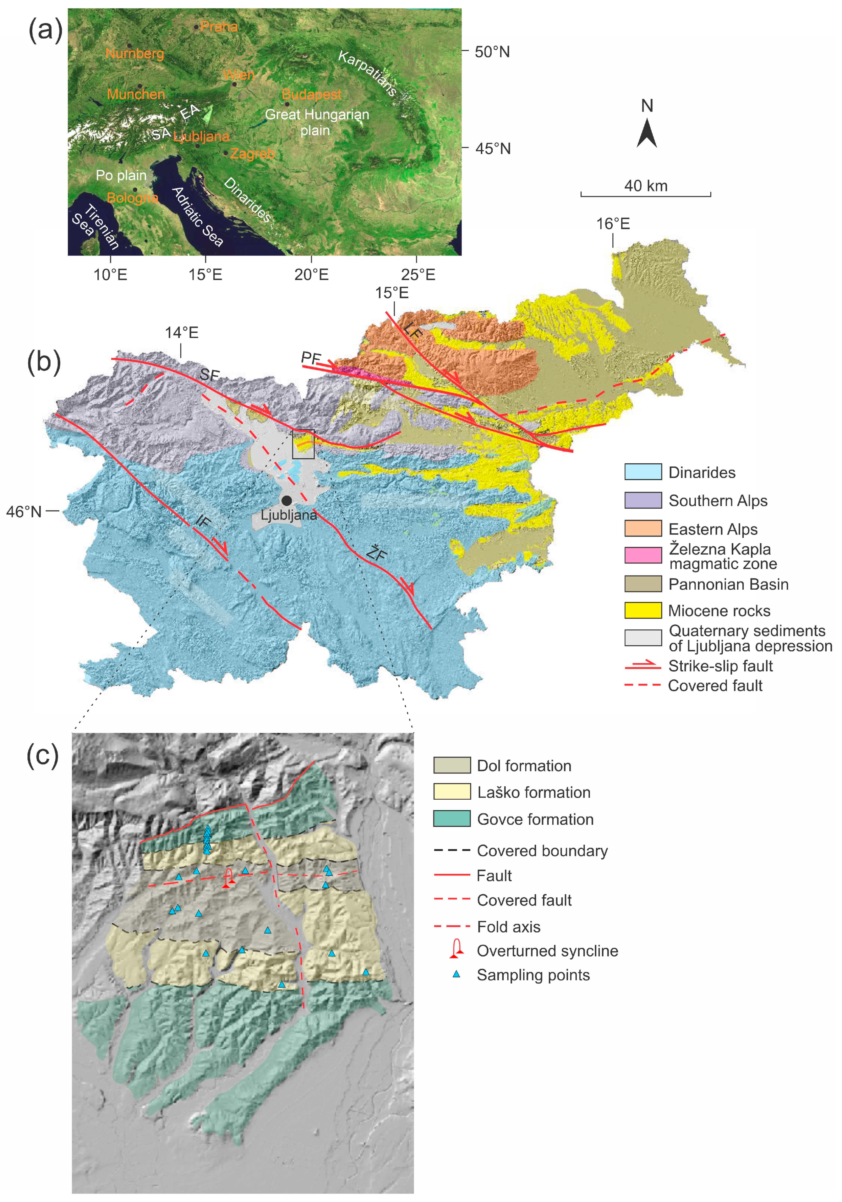
2. Geological Setting
3. Materials and Methods
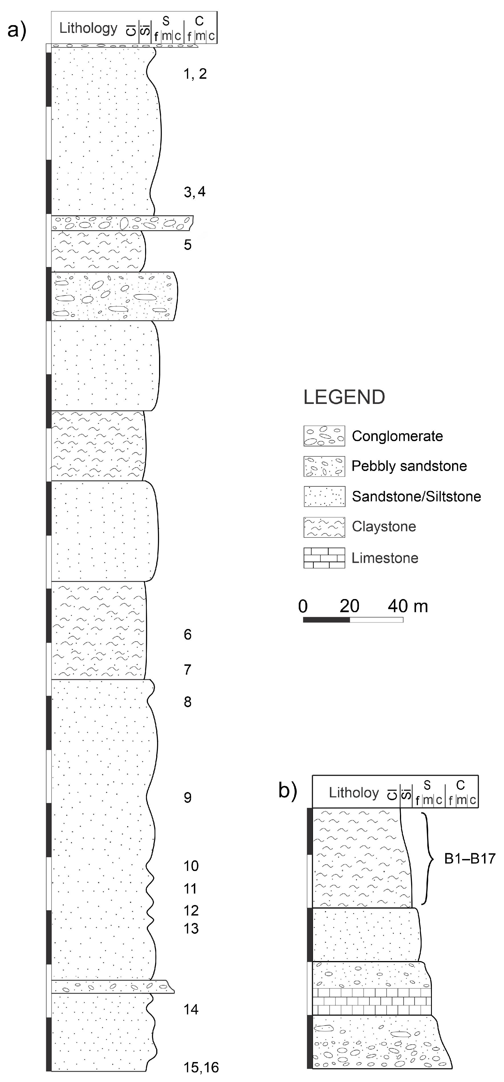
3.1. Sampling
3.2. Methods
3.2.1. Mineralogical Analysis
3.2.2. Geochemical Analysis
4. Results
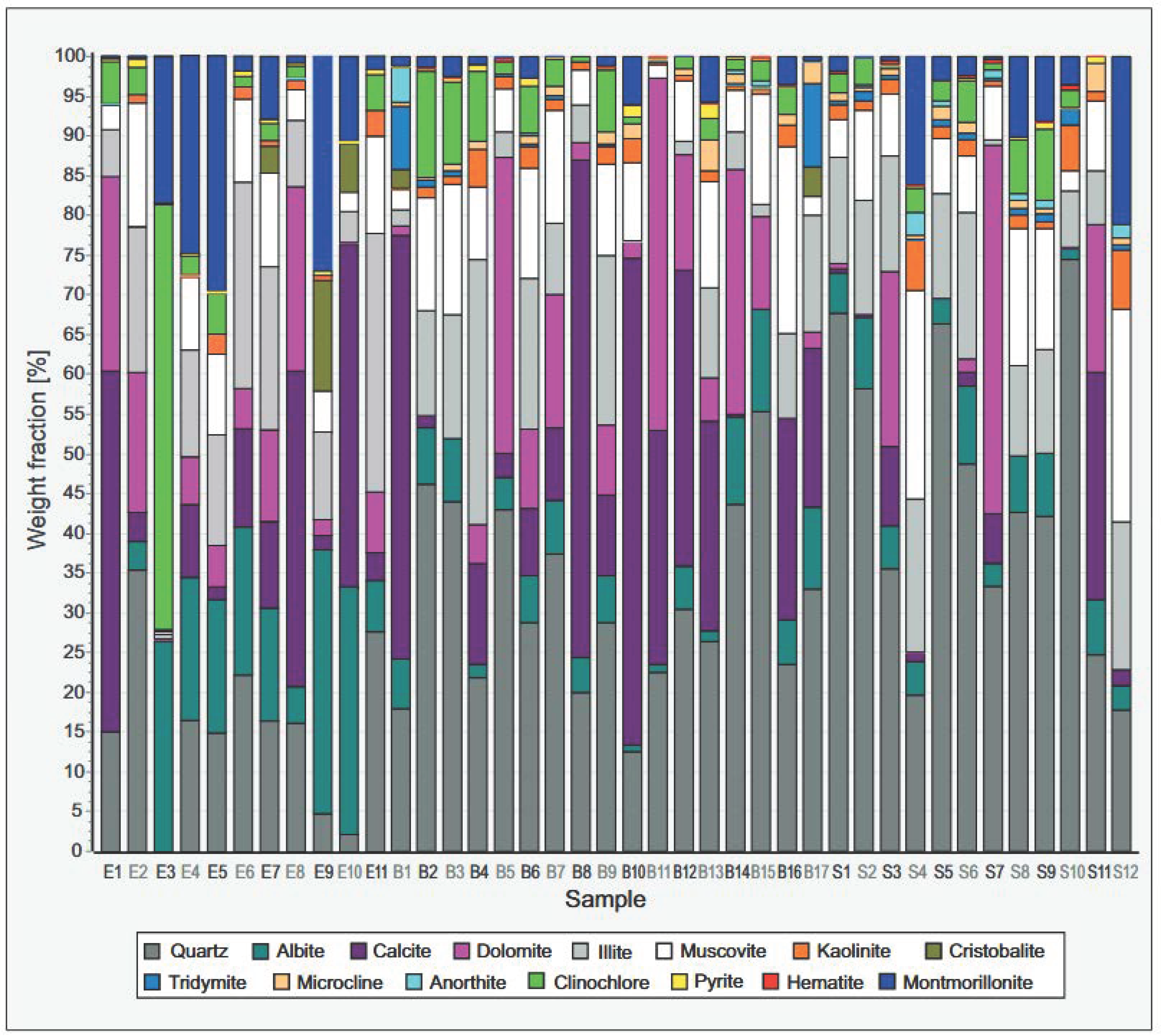
4.1. Mineralogy
4.2. Geochemistry Composition (Major Oxides)
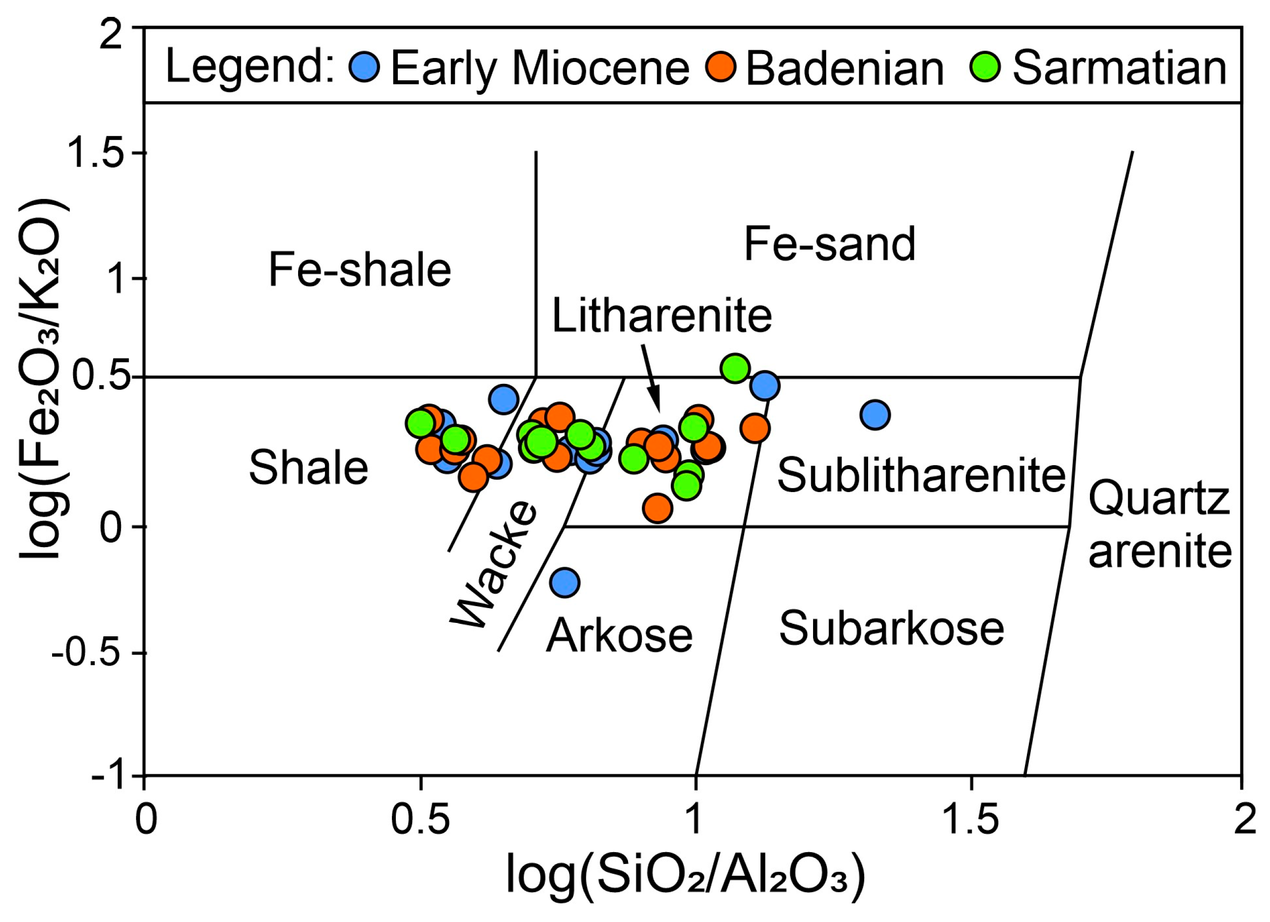
4.3. Ternary and Discriminant Diagrams Based on Major Oxides
5. Discussion
5.1. Paleoweathering
5.2. Provenance
5.2.1. Mineralogical Approach
5.2.2. Geochemical Approach
5.3. Tectonic Setting
Interpretation of Tectonic Setting of the Tunjice Hills (Western Central Paratethys)
6. Conclusions
- -
- The heterogeneous mineral and chemical composition and alteration in their abundance suggest a markedly wide area of origin of the sediments. The studied rocks are rich in quartz and poor in feldspars and indicate quartzose sedimentary provenance. Source areas of sediments were connected with an origin from the Southern Alps, Austroalpine units of the Eastern Alps, Eisenkappel magmatic zone, and the Smrekovec volcanic complex.
- -
- The paleoweathering ternary diagram turned out to be very reliable. The Early Miocene rocks of the Tunjice Hills have the lowest CIA, while the youngest rocks (Badenian and Sarmatian) have the highest CIA value. Results are consistent with the differences in paleoclimatic conditions during the Early and Middle Miocene, which ranged from colder to warmer and more humid climates. The latter corresponds well with the MMCO.
- -
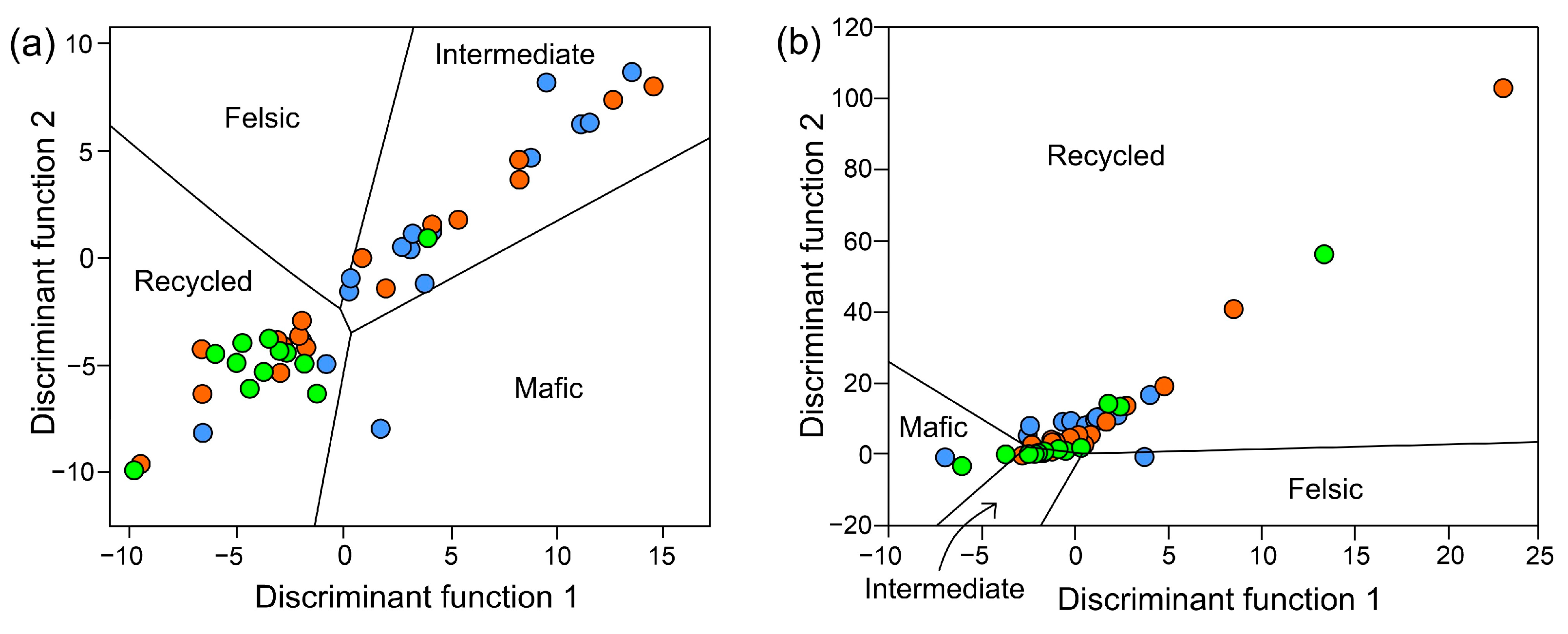
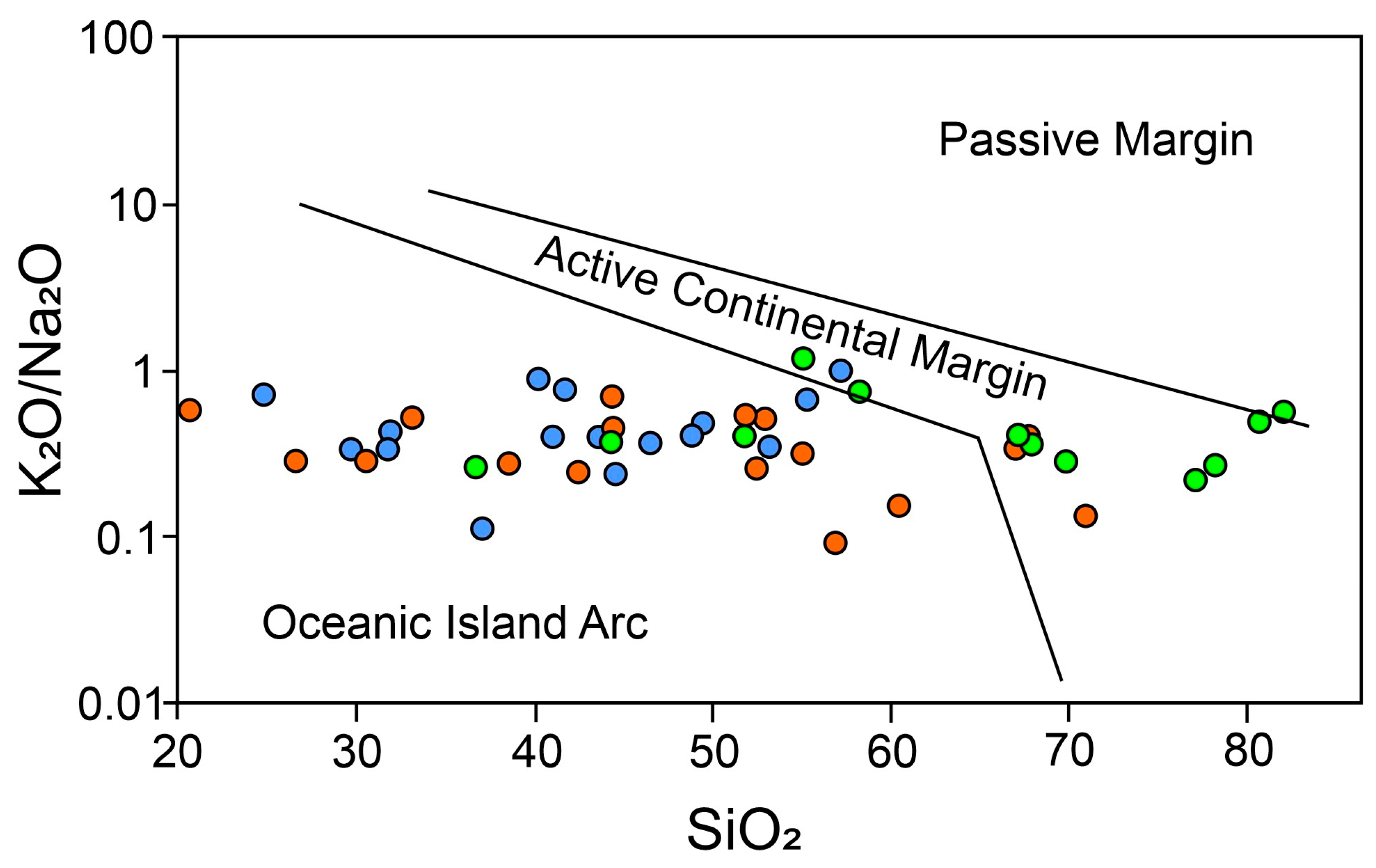
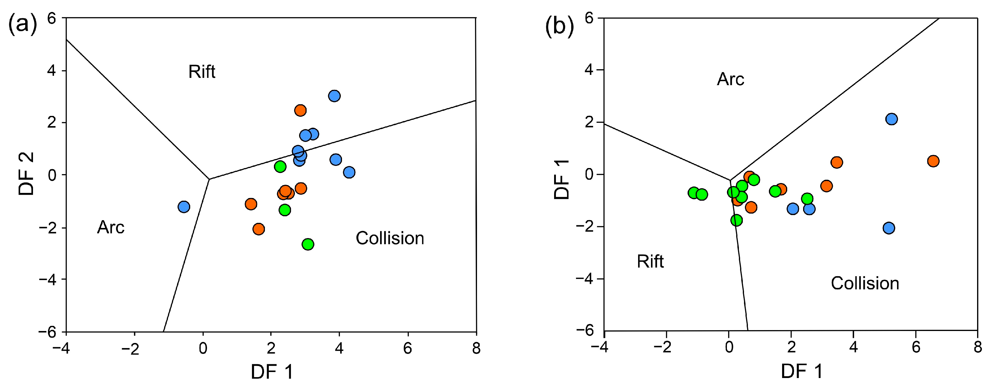
- The discriminant function of Roser and Korsch [66] and the discriminant function of Verma and Armstrong Altrin [3] have proved to be very useful in determining the tectonic setting of the source sediment. It appears that the source sediments in the Tunjice Hills were subjected to oceanic island arc and collision setting, which corresponds well with the hinterland. However, the passive margin connected to the evolution of the Pannonian Basin and the possible influence of the intra-plate settings near the Middle Hungarian Zone was also identified.
- -
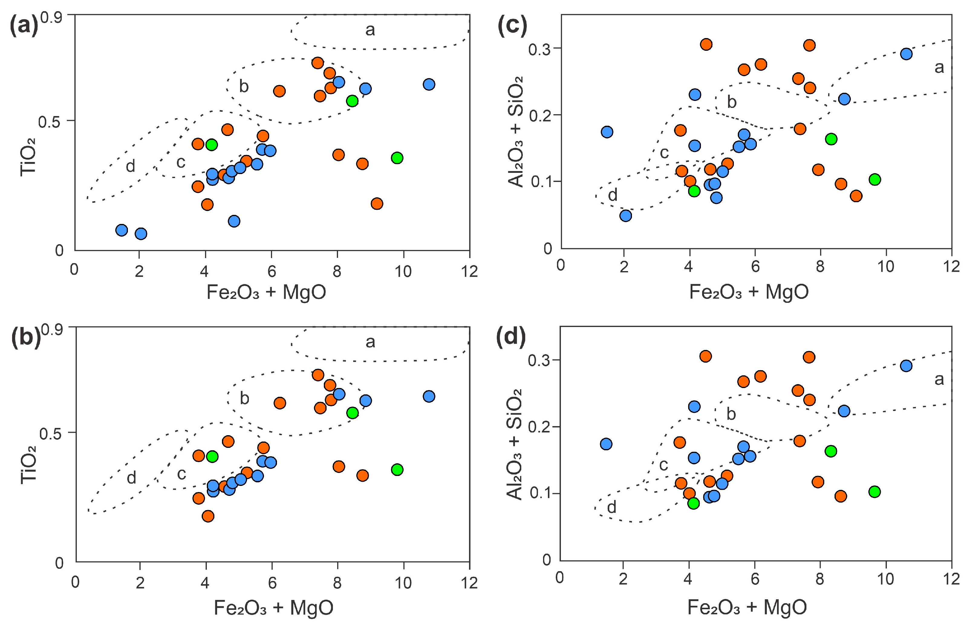
- The discriminant functions of Bathia [68] are the only ones that were unreliable. Additional analyses showed that the diagram did not include the samples in the specific groups and the results could not be put into context, so the use of the diagram is not recommended.
- -
- Sedimentation in the Tunjice Hills, located south of the Southern Alps and representing the western margin of the PBS, was strongly influenced by both active and passive margin settings. This was demonstrated by multidimensional diagrams, as presented by Verma and Armstrong Altrin [2,3]. However, the results did not allow for the determination of the specific influence of each setting during a given period. Based on the regional tectonic evolution of the PBS and Alpine orogen, it is important to note that the collision zone had a stronger impact on sedimentation during the Early Miocene and the rift setting during the Middle Miocene. Nevertheless, the sedimentary input may have originated from a collision zone and had been deposited in an area where the rift zone was already active.
Supplementary Materials
Author Contributions
Funding
Institutional Review Board Statement
Informed Consent Statement
Data Availability Statement
Acknowledgments
Conflicts of Interest
Abbreviations
| PBS | Pannonian Basin System |
| CIA | Chemical index of alteration |
| TOC | Total organic carbon |
| MMCO | Middle Miocene Climatic Optimum |
References
- Zakir, H.M. Major, Trace, and REE Geochemistry of the Meghna River Sediments, Bangladesh: Constraints on Weathering and Provenance. Geol. J. 2020, 55, 3321–3343. [Google Scholar] [CrossRef]
- Verma, S.P.; Armstrong-Altrin, J.S. Geochemical Discrimination of Siliciclastic Sediments from Active and Passive Margin Settings. Sediment. Geol. 2016, 332, 1–12. [Google Scholar] [CrossRef]
- Verma, S.P.; Armstrong-Altrin, J.S. New Multi-Dimensional Diagrams for Tectonic Discrimination of Siliciclastic Sediments and Their Application to Precambrian Basins. Chem. Geol. 2013, 355, 117–133. [Google Scholar] [CrossRef]
- Nesbitt, H.W.; Young, G.M. Foramtion and Diagenesis of Weathering Profiles. J. Geol. 1989, 97, 129–147. [Google Scholar] [CrossRef]
- Fralick, P.W.; Kronberg, B.I. Geochemical Discrimination of Clastic Sedimentary Rock Sources. Sediment. Geol. 1997, 113, 111–124. [Google Scholar] [CrossRef]
- Zimmermann, U.; Heinrich, B. Provenance Analysis and Tectonic Setting of the Ordovician Clastic Deposits in the Southern Puna Basin, NW Argentina. Sedimentology 2003, 50, 1079–1104. [Google Scholar] [CrossRef]
- Zhang, Y.; Pe-Piper, G.; Piper, D.J.W. Sediment geochemistry as a provenance indicator: Unravelling the cryptic signatures of polycyclic sources, climate change, tectonism and volcanis. Sedimentology 2014, 61, 383–410. [Google Scholar] [CrossRef]
- Armstrong-Altrin, J.S.; Nagarajan, R.; Balaram, V.; Natalhy-Pineda, O. Petrography and Geochemistry of Sands from the Chachalacas and Veracruz Beach Areas, Western Gulf of Mexico, Mexico: Constraints on Provenance and Tectonic Setting. J. South Am. Earth Sci. 2015, 64, 199–216. [Google Scholar] [CrossRef]
- Baldermann, A.; Abdullayev, E.; Taghiyeva, Y.; Alasgarov, A.; Javad-Zada, Z. Sediment Petrography, Mineralogy and Geochemistry of the Miocene Islam Da?G Section (Eastern Azerbaijan): Implications for the Evolution of Sediment Provenance, Palaeo-Environment and (Post-)Depositional Alteration Patterns. Sedimentology 2020, 67, 152. [Google Scholar] [CrossRef]
- Kan, W.; Yang, Z.; Yu, L.; Sun, M. Provenance and Tectonic Setting of Formation of Quaternary Sedimentary Successions from the Songhua River, Northeast China. Appl. Sci. 2022, 12, 7356. [Google Scholar] [CrossRef]
- Bahlburg, H.; Dobrzinski, N. A Review of the Chemical Index of Alteration (CIA) and Its Application to the Study of Neoproterozoic Glacial Deposits and Climate Transitions. In The Geological Record of Neoproterozoic Glaciations; Arnaud, E., Halverson, G.P., Shields-Zhou, G., Eds.; Geological Society of London: London, UK, 2011; pp. 81–92. [Google Scholar]
- Adeigbe, O.C.; Jimoh, Y.A. Geochemical Fingerprints; Implication for Provenance, Tectonic and Depositional Settings of Lower Benue Trough Sequence, Southeastern Nigeria. J. Environ. Earth Sci. 2013, 3, 115–141. [Google Scholar]
- Yan, Y.; Xia, B.; Lin, G.; Carter, A.; Hu, X.; Cui, X.; Liu, B.; Yan, P.; Song, Z. Geochemical and Nd Isotope Composition of Detrital Sediments on the North Margin of the South China Sea: Provenance and Tectonic Implications. Sedimentology 2007, 54, 1–17. [Google Scholar] [CrossRef]
- Ofili, S.; Soesoo, A.; Panova, G.E.; Hints, R.; Hade, S.; Ainsaar, L. Geochemical Reconstruction of the Provenance, Tectonic Setting and Paleoweathering of Lower Paleozoic Black Shales from Northern Europe. Minerals 2022, 12, 602. [Google Scholar] [CrossRef]
- Ivančič, K.; Trajanova, M.; Skaberne, D.; Šmuc, A. Provenance of the Miocene Slovenj Gradec Basin Sedimentary Fill, Western Central Paratethys. Sediment. Geol. 2018, 375, 256–267. [Google Scholar] [CrossRef]
- Krissek, L.A.; Kyle, P.R. Geochemical Indicators of Weathering, Cenozoic Palaeoclimates, and Provenance in Fine-Grained Sediments from CRP-3, Victoria Land Basin, Antarctica. Terra Antarct. 2000, 8, 561–568. [Google Scholar]
- Royden, H.L.; Horvath, F. Introduction to the Pannonian Region. In The Pannonian Basin: A Study in Basin Evolution; Royden, H.L., Horvath, F., Eds.; American Association of Petroleum Geologists: Tulsa, OK, USA, 1988; ISBN 978-1-62981-134-5. [Google Scholar]
- Ustaszewski, K.; Schmid, S.M.; Fügenschuh, B.; Tischler, M.; Kissling, E.; Spakman, W. A Map-View Restoration of the Alpine-Carpathian-Dinaridic System for the Early Miocene. Swiss J. Geosci. 2008, 101, 273–294. [Google Scholar] [CrossRef]
- Schmid, S.M.; Fügenschuh, B.; Kounov, A.; Maţenco, L.; Nievergelt, P.; Oberhänsli, R.; Pleuger, J.; Schefer, S.; Schuster, R.; Tomljenović, B.; et al. Tectonic Units of the Alpine Collision Zone between Eastern Alps and Western Turkey. Gondwana Res. 2020, 78, 308–374. [Google Scholar] [CrossRef]
- Schmid, S.M.; Fügenschuh, B.; Kissling, E.; Schuster, R. Tectonic Map and Overall Architecture of the Alpine Orogen. Eclogae Geol. Helv. 2004, 97, 93–117. [Google Scholar] [CrossRef]
- Tomljenović, B.; Csontos, L. Neogene-Quaternary Structures in the Border Zone between Alps, Dinarides and Pannonian Basin (Hrvatsko Zgorje and Karlovac Basins, Croatia). Int. J. Earth Sci. 2001, 90, 560–578. [Google Scholar] [CrossRef]
- Handy, M.R.; Ustaszewski, K.; Kissling, E. Reconstructing the Alps–Carpathians–Dinarides as a Key to Understanding Switches in Subduction Polarity, Slab Gaps and Surface Motion. Int. J. Earth Sci. 2014, 104, 1–26. [Google Scholar] [CrossRef]
- Kováč, M.; Halásová, E.; Hudáčková, N.; Holcová, K.; Hyžný, M.; Jamrich, M.; Ruman, A. Towards Better Correlation of the Central Paratethys Regional Time Scale with the Standard Geological Time Scale of the Miocene Epoch. Geol. Carpathica 2018, 69, 283–300. [Google Scholar] [CrossRef]
- Kováč, M.; Hudáčková, N.; Halásová, E.; Kováčová, M.; Holcová, K.; Oszczypko-Clowes, M.; Báldi, K.; Less, G.; Nagymarosy, A.; Ruman, A.; et al. The Central Paratethys Palaeoceanography: A Water Circulation Model Based on Microfossil Proxies, Climate, and Changes of Depositional Environment. Acta Geol. Slovaca 2017, 9, 75–114. [Google Scholar]
- Grizelj, A.; Peh, Z.; Tiblja, D. Mineralogical and Geochemical Characteristics of Miocene Pelitic Sedimentary Rocks from the South-Western Part of the Pannonian Basin System (Croatia): Implications for Provenance Studies. Geosci. Front. 2017, 8, 65–80. [Google Scholar] [CrossRef]
- Ali, A.; Wagreich, M. Geochemistry, Environmental and Provenance Study of the Middle Miocene Leitha Limestones (Central Paratethys). Geol. Carpathica 2017, 68, 248–268. [Google Scholar] [CrossRef]
- Slovenec, D.; Lugovic, B. Amphibole Gabbroic Rocks from the Mt. Medvednica Ophiolite Mélange (NW Croatia): Geochemistry and Tectonic Setting. Geol. Carpathica 2008, 59, 277–293. [Google Scholar]
- Grizelj, A.; Tibljaš, D.; Kovačicć, M. Mineralogy and Geochemistry of Upper Miocene Pelitic Sediments of the Zagorje Basin (Croatia): Implication for Evolution of the Pannonian Basin. Geol. Carpathica 2007, 58, 263–276. [Google Scholar]
- Fodor, L.; Csontos, L.; Bada, G.; Györfi, I.; Benkovics, L. Tertiary Tectonic Evolution of the Pannonian Basin System and Neighbouring Orogens: A New Synthesis of Palaeostress Data. Geol. Soc. Lond. Spec. Publ. 1999, 156, 295–334. [Google Scholar] [CrossRef]
- Huismans, R.S.; Podladchikov, Y.Y.; Cloetingh, S.A.P.L. The Pannonian Basin: Dynamic Modelling of the Transition from Passive to Active Rifting. Stephan Mueller Spec. Publ. Ser. 2001, 3, 41–63. [Google Scholar] [CrossRef]
- Fodor, L.; Bada, G.; Csillag, G.; Horváth, E.; Ruszkiczay-Rüdiger, Z.; Palotás, K.; Síkhegyi, F.; Timár, G.; Cloetingh, S.; Horváth, F. An Outline of Neotectonic Structures and Morphotectonics of the Western and Central Pannonian Basin. Tectonophysics 2005, 410, 15–41. [Google Scholar] [CrossRef]
- Tari, G.; Báldi, T.; Báldi-Beke, M. Paleogene Retroarc Flexural Basin beneath the Neogene Pannonian Basin: A Geodynamic Model. Tectonophysics 1993, 226, 433–455. [Google Scholar] [CrossRef]
- Lorinczi, P.; Houseman, G. Geodynamical Models of Lithospheric Deformation, Rotation and Extension of the Pannonian Basin of Central Europe. Tectonophysics 2010, 492, 73–87. [Google Scholar] [CrossRef]
- Csontos, L.; Nagymarosy, A. The Mid-Hungarian Line: A Zone of Repeated Tectonic Inversions. Tectonophysics 1998, 297, 51–71. [Google Scholar] [CrossRef]
- Froitzheim, N.; Schmid, S.M. Orogenic Processes in the Alpine Collision Zone. Swiss J. Geosci. 2008, 101, 7–9. [Google Scholar] [CrossRef]
- Sachsenhofer, R.F.; Jelen, B.; Hasenhüttl, C.; Dunkl, I.; Rainer, T. Thermal History of Tertiary Basins in Slovenia (Alpine-Dinaride-Pannonian Junction). Tectonophysics 2001, 334, 77–99. [Google Scholar] [CrossRef]
- Pavelić, D.; Kovačić, M. Sedimentology and Stratigraphy of the Neogene Rift-Type North Croatian Basin (Pannonian Basin System, Croatia): A Review. Mar. Pet. Geol. 2018, 91, 455–469. [Google Scholar] [CrossRef]
- Ivančič, K.; Trajanova, M.; Ćorić, S.; Rožič, B.; Šmuc, A. Miocene Paleogeography and Biostratigraphy of the Slovenj Gradec Basin: A Marine Corridor between the Mediterranean and Central Paratethys. Geol. Carpathica 2018, 69, 528–544. [Google Scholar] [CrossRef]
- Vlček, T.; Šarinová, K.; Rybár, S.; Hudáčková, N.; Jamrich, M.; Šujan, M.; Franců, J.; Nováková, P.; Sliva, Ľ.; Kováč, M.; et al. Paleoenvironmental Evolution of Central Paratethys Sea and Lake Pannon during the Cenozoic. Palaeogeogr. Palaeoclimatol. Palaeoecol. 2020, 559, 109892. [Google Scholar] [CrossRef]
- Hohenegger, J.; Coric, S.; Wagreich, M. Timing of the Middle Miocene Badenian Stage of the Central Paratethys. Geol. Carpathica 2014, 65, 55–66. [Google Scholar] [CrossRef]
- Rögl, F. Mediterranean and Paratethys. Facts and Hypotheses of an Oligocene to Miocene Paleogeography (Short Overview). Geol. Carpathica 1999, 50, 339–349. [Google Scholar]
- Mandić, O.; Kurečić, T.; Neubauer, T.A.; Harzhauser, M. Stratigraphic and Paleogeographic Significance of Lacustrine Mollusks from the Pliocene Viviparus Beds in Central Croatia. Geol. Croat. 2015, 68, 179–207. [Google Scholar] [CrossRef]
- Piller, W.E.; Harzhauser, M.; Mandic, O. Miocene Central Paratethys Stratigraphy—Current Status and Future Directions. Stratigraphy 2007, 4, 151–168. [Google Scholar] [CrossRef]
- Rögl, F. Palaeogeographic Considerations for Mediterranean and Paratethys Seaways (Oligocene to Miocene). Ann. Naturhistorischen Mus. Wien 1998, 99A, 279–310. [Google Scholar]
- Vrabec, M.; Pavlovcic Preseren, P.; Stopar, B. GPS Study (1996–2002) of Active Deformation along the Paeriadriatic Fault System in Northeastern Slovenia: Tectonic Model. Geol. Carpathica 2006, 57, 57–65. [Google Scholar]
- Mlakar, I. On the Age of the Lower Part of Pseudozilian Beds in the Region of Cerkno. Geologija 1980, 23, 173–176. [Google Scholar]
- Premru, U. Osnovna Geološka Karta SFRJ 1:100.000. Tolmač Lista Ljubljana; Zvezni Geološki Zavod: Belgrade, Serbia, 1983. [Google Scholar]
- Janák, M.; Froitzheim, N.; Vrabec, M.; Krogh Ravna, E.J.; De Hoog, J.C.M. Ultrahigh-Pressure Metamorphism and Exhumation of Garnet Peridotite in Pohorje, Eastern Alps. J. Metamorph. Geol. 2006, 24, 19–31. [Google Scholar] [CrossRef]
- Frisch, W.; Dunkl, I.; Kuhlemann, J. Post-Collisional Orogen-Parallel Large-Scale Extension in the Eastern Alps. Tectonophysics 2000, 327, 239–265. [Google Scholar] [CrossRef]
- Kralj, P. Pottasium Feldspars in the Smrekovec Volcaniclastic Rocks—A Byproduct of the Reaction from Laumontite to Analcime. Geologija 2001, 44, 325–330. [Google Scholar] [CrossRef]
- Vlahović, I.; Tišljar, J.; Velić, I.; Matičec, D. Evolution of the Adriatic Carbonate Platform: Palaeogeography, Main Events and Depositional Dynamics. Palaeogeogr. Palaeoclimatol. Palaeoecol. 2005, 220, 333–360. [Google Scholar] [CrossRef]
- Placer, L. Principles of the Tectonic Subdivision of Slovenia. Geologija 2008, 51, 205–217. [Google Scholar] [CrossRef]
- Vrabec, M. Govški Peščenjak v Profilu Doblič; Univerza v Ljubljani: Ljubljana, Slovenia, 2000. [Google Scholar]
- Gašparič, R.; Križnar, M. Early Miocene Decapod Retropluma Slovenica Gašparič & Hyžný, 2014 from Govce Beds of Tunjice Hills (Central Slovenia). Geologija 2017, 60, 77–85. [Google Scholar] [CrossRef]
- Kuščer, D. Zagorski Terciar. Geologija 1967, 10, 5–85. [Google Scholar]
- Avanić, R.; Pavelić, D.; Pécskay, Z.; Miknić, M.; Tibljaš, D.; Wacha, L. Tidal Deposits in the Early Miocene Central Paratethys: The Vučji Jarek and Čemernica Members of the Macelj Formation (NW Croatia). Geol. Croat. 2021, 74, 41–56. [Google Scholar] [CrossRef]
- Haq, B.U.; Hardenbol, J.; Vail, P.R. Mesozoic and Cenozoic Chronostratigraphy and Cycles of Sea Level Changes. In Sea-Level Changes—An Integrated Approach; Wilgus, C.K., Hastings, B.S., Kendall, C., Posamentie, H., Ross, C.A., Van Wagoner, J., Eds.; SEPM Special Publications: Tulsa, OK, USA, 1988; Volume 42, pp. 71–108. [Google Scholar] [CrossRef]
- Holcová, K.; Doláková, N.; Nehyba, S.; Vacek, F. Timing of Langhian Bioevents in the Carpathian Foredeep and North Ern Pannonian Ba Sin in Re La Tion to Ocean o Graphic, Tec Tonic and Cli Ma Tic pro Cesses. Geol. Q. 2018, 62, 3–17. [Google Scholar]
- Mikuž, V. Miocene Sea Mussels from Neighbourhood of Stolnik in Tunjiško Gričevje Tunjice Hills), Slovenia. Geologija 2009, 52, 153–164. [Google Scholar] [CrossRef]
- Vrabec, M. Strukturna Analiza Cone Savskega Preloma Med Trstenikom in Stahovico. Ph.D. Thesis, Univerza v Ljubljani, Ljubljana, Slovenia, 2001. [Google Scholar]
- Atanackov, J.; Jamšek Rupnik, P.; Jež, J.; Celarc, B.; Novak, M.; Milanič, B.; Markelj, A.; Bavec, M.; Kastelic, V. Database of Active Faults in Slovenia: Compiling a New Active Fault Database at the Junction Between the Alps, the Dinarides and the Pannonian Basin Tectonic Domains. Front. Earth Sci. 2021, 9, 604388. [Google Scholar] [CrossRef]
- Kresevič, A. Sedimentologija in Tektonska Struktura Srednjemiocenskih Plasti v Tunjiškem Gričevju. Bachelor’s Thesis, University of Ljubljana, Ljubljana, Slovenia, 2016. Available online: https://repozitorij.uni-lj.si/IzpisGradiva.php?lang=slv&id=87833 (accessed on 3 January 2024).
- Rojnik, A. Sedimentološke in Petrološke Značilnosti Klastičnih Kamnin Laške Formacije v Profilu Doblič. Bachelor’s Thesis, University of Ljubljana, Ljubljana, Slovenia, 2015. Available online: https://repozitorij.uni-lj.si/IzpisGradiva.php?lang=eng&id=73303 (accessed on 3 January 2024).
- Zachos, J.; Pagani, M.; Sloan, L.; Thomas, E.; Billups, K. Trends, Rhythms, and Aberrations in Global Climate 65 Ma to Present. Science 2001, 292, 686–693. [Google Scholar] [CrossRef] [PubMed]
- Nesbitt, H.W.; Young, G.M. Prediction of Some Weathering Trends of Plutonic and Volcanic Rocks Based on Thermodynamic and Kinetic Considerations. Geochim. Cosmochim. Acta 1984, 48, 1523–1534. [Google Scholar] [CrossRef]
- Roser, B.P.; Korsch, R.J. Provenance Signatures of Sandstone-Mudstonen Suites Determined Using Discriminant Function of Major-Element Data. Chem. Geol. 1988, 67, 119–139. [Google Scholar] [CrossRef]
- Oni, S.O.; Olatunji, A.S.; Ehinola, O.A. Determination of Provenance and Tectonic Settings of Niger Delta Clastic Facies Using Well-Y, Onshore Delta State, Nigeria. J. Geochem. 2014, 2014, 960139. [Google Scholar] [CrossRef]
- Bhatia, M.R. Plate Tectonics and Geochemical Composition of Sandstone. J. Geol. 1983, 91, 611–627. [Google Scholar] [CrossRef]
- Herron, M.M. Geochemical Classification of Terrigenous Sands and Shales from Core or Log Data. SEPM J. Sediment. Res. 1988, 58, 820–829. [Google Scholar] [CrossRef]
- Hu, J.; Li, Q.; Fang, N.; Yang, J.; Ge, D. Geochemistry Characteristics of the Low Permian Sedimentary Rocks from Central Uplift Zone, Qiangtang Basin, Tibet: Insights into Source-Area Weathering, Provenance, Recycling, and Tectonic Setting. Arab. J. Geosci. 2015, 8, 5373–5388. [Google Scholar] [CrossRef]
- Fedo, C.M.; Nesbitt, H.W.; Young, G.M. Unravelling the Effects of Potassium Metasomatism in Sedimentary Rocks and Paleosols, with Implications for Paleoweathering Conditions and Provenance. Geology 1995, 23, 921–924. [Google Scholar] [CrossRef]
- Tawfik, H.A.; Ghandour, I.M.; Maejima, W.; Armstrong-Altrin, J.S.; Abdel-Monem, T.; Abdel-Hameed, A.-M.T. Petrography and Geochemistry of the Siliciclastic Araba Formation (Cambrian), East Sinai, Egypt: Implications for Provenance, Tectonic Setting and Source Weathering. Geol. Mag. 2015, 154, 1–23. [Google Scholar] [CrossRef]
- Harzhauser, M.; Piller, W.E. Benchmark Data of a Changing Sea—Palaeogeography, Palaeobiogeography and Events in the Central Paratethys during the Miocene. Palaeogeogr. Palaeoclimatol. Palaeoecol. 2007, 253, 8–31. [Google Scholar] [CrossRef]
- Weaver, C.E. Clays, Muds, and Shales; Elsevier Science Publishels B.V.: Amsterdam, The Netherlands, 1989. [Google Scholar]
- Kováčová, M.; Doláková, N.; Kovac, M. Miocene Vegetation Pattern and Climate Change in the Northwestern Central Paratethys Domain (Czech and Slovak Republic). Geol. Carpathica 2011, 62, 251–266. [Google Scholar] [CrossRef]
- Kováčová, M.; Sitár, V. Early Miocene Flora of the South Slovakian Basin. Acta Palaeobot. 2007, 47, 163–181. [Google Scholar]
- Karami, M.P.; de Leeuw, A.; Krijgsman, W.; Meijer, P.T.; Wortel, M.J.R. The Role of Gateways in the Evolution of Temperature and Salinity of Semi-Enclosed Basins: An Oceanic Box Model for the Miocene Mediterranean Sea and Paratethys. Glob. Planet. Chang. 2011, 79, 73–88. [Google Scholar] [CrossRef]
- Pavelić, D.; Kovačić, M.; Banak, A.; Jiménez-Moreno, G.; Marković, F.; Pikelj, K.; Vranjković, A.; Premužak, L.; Tibljaš, D.; Belak, M. Early Miocene European Loess: A New Record of Aridity in Southern Europe. Geol. Soc. Am. Bull. 2016, 128, 110–121. [Google Scholar] [CrossRef]
- Kováč, M.; Andreyeva-Grigorovich, A.; Bajraktarević, Z.; Brzobohatý, R.; Filipescu, S.; Fodor, L.; Harzhauser, M.; Nagymarosy, A.; Oszczypko, N.; Pavelić, D.; et al. Badenian Evolution of the Central Paratethys Sea: Paleogeography, Climate and Eustatic Sea-Level Changes. Geol. Carpathica 2007, 58, 579–606. [Google Scholar]
- Abreu, V.S.; Haddad, G.A. Glacioeustatic Fluctuations: The Mechanism Linking Stable Isotope Events and Sequence Stratigraphy from the Early Oligocene to Middle Miocene. In Mesozoic and Cenozoic Sequence Stratigraphy of European Basins; Graciansky, C.-P., Hardenbol, J., Jacquin, T., Vail, P.R., Eds.; SEPM Special Publications: Tulsa, OK, USA, 1998; Volume 60, pp. 245–260. [Google Scholar]
- Alqahtani, F.; Khalil, M. Geochemical Analysis for Evaluating the Paleoweathering, Paleoclimate, and Depositional Environments of the Siliciclastic Miocene-Pliocene Sequence at Al-Rehaili Area, Northern Jeddah, Saudi Arabia. Arab. J. Geosci. 2021, 14, 239. [Google Scholar] [CrossRef]
- Mustafa, R.K. Geochemical Application in Unraveling Paleoweatherin, Provenance and Environmental Setting of the Shale from Chia Gara Formation, Kurdistan Region. Iraqi Geol. J. 2020, 53, 90–116. [Google Scholar] [CrossRef]
- Dress, L.R.; Wilding, L.P.; Smeck, N.E.; Senkayi, A.L. Silica in Soils: Quartz and Disordered Silica Polymorphs. In Minerals in Soil Environments; Dixon, J.B., Ed.; Soil Science Society of America: Madison, WI, USA, 1989; pp. 913–965. [Google Scholar]
- Tišljar, J. Sedimentologija Klastičnih i Silicijskih Taložina; Velić, I., Ed.; Institud z.; Nacionalna i sveučilišna knjižnica-Zagreb: Zagreb, Croatia, 2004. [Google Scholar]
- McKosky, J.A. Quartz in Provenance Examination. Master’s Thesis, Michigan State University, Lansing, MI, USA, 1975. [Google Scholar]
- Trajanova, M.; Pecskay, Z.; Itaya, T. K-Ar Geochronology and Petrography of the Miocene Pohorje Mountains Batholith (Slovenia). Geol. Carpathica 2008, 59, 247–260. [Google Scholar]
- Janák, M.; Froitzheim, N.; Lupták, B.; Vrabec, M.; Ravna, E.J.K. First Evidence for Ultrahigh-Pressure Metamorphism of Eclogites in Pohorje, Slovenia: Tracing Deep Continental Subduction in the Eastern Alps. Tectonics 2004, 23, 1–10. [Google Scholar] [CrossRef]
- White, B.W. Speleothems. In Encyclopedia of Caves; White, W.B., Culver, D.C., Pipan, T., Eds.; Academic Press: Cambridge, MA, USA, 2019; pp. 1006–1017. ISBN 978-0-12-814124-3. [Google Scholar]
- Sulpis, O.; Jeansson, E.; Dinauer, A.; Lauvset, S.K.; Middelburg, J.J. Calcium Carbonate Dissolution Patterns in the Ocean. Nat. Geosci. 2021, 14, 423–428. [Google Scholar] [CrossRef]
- Piller, W.E.; Harzhauser, M. The Myth of the Brackish Sarmatian Sea. Terra Nova 2005, 17, 450–455. [Google Scholar] [CrossRef]
- Pettijohn, F.J.; Potter, P.E.; Siever, R. Sand and Sandstone; Springer: New York, NY, USA, 1972. [Google Scholar]
- Hinterlechner-Ravnik, A. Zeleni Skrilavci Kranjske Rebri. Geologija 1978, 21, 245–254. [Google Scholar]
- Trajanova, M. Uvod v Magmatske Kamnine Slovenije = Introducton to Igneous Rocks of Slovenia. In Geologija Slovenije = The Geology of Slovenia; Pleničar, M., Ogorelec, B., Novak, M., Eds.; Geološki Zavod Slovenije: Ljubljana, Slovenia, 2009; pp. 467–468. ISBN 978-961-6498-24-1. [Google Scholar]
- Ney, R.; Burzewski, W.; Bachleda, T.; Górecki, W.; Jakóbczak, K.; Supczyñski, K. Outline of Paleogeography and Evolu-Tion of Lithology and Facies of Miocene Layers on the Car-Pathian Foredeep. Prace Geol. 1974, 82, 1–65. [Google Scholar]
- Săndulescu, M. Cenozoic Tectonic History of the Carpathians. In The Pannonian Basin—A Study in Basin Evolution; Royden, L., Horvath, F., Eds.; The American Associationof Petroleum Geologists and The Hungarian Geological Society, AAPG: Tulsa, OK, USA, 1988; pp. 17–26. [Google Scholar]
- Meunier, A.; Caner, L.; Hubert, F.; El Albani, A.; Pret, D. The Weathering Intensity Scale (WIS): An Alternative Approach of the Chemical Index of Alteration (CIA). Am. J. Sci. 2013, 313, 113–143. [Google Scholar] [CrossRef]
- Berner, R.A. Sedimentary Pyrite Formation: An Update. Geochim. Cosmochim. Acta 1984, 48, 605–615. [Google Scholar] [CrossRef]
- Ćorić, S.; Pavelić, D.; Rögl, F.; Mandic, O.; Vrabac, S. Revised Middle Miocene Datum for Initial Marine Flooding of North Croatian Basins (Pannonian Basin System, Central Paratethys). Geol. Croat. 2009, 62, 31–43. [Google Scholar] [CrossRef]
- Girty, G.; Ridge, D.L.; Knaack, C.; Johnson, D.; Al-Riyami, R.K. Provenance and Depositional Setting of Paleozoic Chert and Argillite, Sierra Nevada, California. J. Sediment. Res. 1996, 66, 107–118. [Google Scholar] [CrossRef]
- Garcia, D.; Moutte, J. Sedimentary Fractionations between Al, Ti, and Zr and the Genesis of Strongly Peraluminous Granites. J. Geol. 1994, 102, 411–422. [Google Scholar] [CrossRef]
- Nagarajan, R.; Armstrong-Altrin, J.S.; Kessler, F.L.; Hidalgo-Moral, E.L.; Dodge-Wan, D.; Taib, N.I. Provenance and Tectonic Setting of Miocene Siliciclastic Sediments, Sibuti Formation, Northwestern Borneo. Arab. J. Geosci. 2015, 8, 8549–8565. [Google Scholar] [CrossRef]
- Spalletti, L.A.; Limarino, C.O.; Piñol, F.C. Petrology and Geochemistry of Carboniferous Siliciclastics from the Argentine Frontal Cordillera: A Test of Methods for Interpreting Provenance and Tectonic Setting. J. South Am. Earth Sci. 2012, 36, 32–54. [Google Scholar] [CrossRef]
- Absar, N.; Sreenivas, B. Petrology and Geochemistry of Greywackes of the ~1.6 Ga Middle Aravalli Supergroup, Northwest India: Evidence for Active Margin Processes. Int. Geol. Rev. 2015, 57, 134–158. [Google Scholar] [CrossRef]
- Zhou, L.; Frii, H.; Poulsen, M.L.K. Geochemical Evaluation of the Late Paleocene and Early Eocene Shales in Siri Canyon, Danish-Norwegian Basin. Mar. Pet. Geol. 2015, 61, 111–122. [Google Scholar] [CrossRef]
- Hayashi, K.I.; Fujisawa, H.; Holland, H.D.; Ohmoto, H. Geochemistry of ~1.9 Ga Sedimentary Rocks from Northeastern Labrador, Canada. Geochim. Cosmochim. Acta 1997, 61, 4115–4137. [Google Scholar] [CrossRef]
- Allaby, M. A Dictionary of Earth Sciences; Oxford University Press: Oxford, UK, 2008; ISBN 9780199211944. [Google Scholar]
- Vrabec, M.; Fodor, L. Late Cenozoic Tectonics of Slovenia: Structural Styles At the Northeastern Corner of the Adriatic Microplate. In The Adria Microplate: GPS Geodesy, Tectonics and HazardsTectonics and Hazards; Pinter, N., Grenerczy, G., Weber, J., Stein, S., Medak, D., Eds.; Nato Science Series IV: Earth and Environmental Sciences (NAIV); Springer: Dordrecht, The Netherlands, 2006; Volume 61, pp. 151–168. [Google Scholar] [CrossRef]
- Fodor, L.; Jelen, B.; Dragomir, S.; Vrabec, M. Miocene-Pliocene Tectonic Evolution of the Slovenian Periadriatic Fault: Implications for Alpine-Carpathian Extrusion Models. Tectonics 1998, 17, 690–709. [Google Scholar] [CrossRef]
- Gale, E.M.; Rupnik, P.J.; Trajanova, M.; Gale, L.; Bavec, M.; Anselmetti, F.S.; Šmuc, A. Provenance and Morphostratigraphy of the Pliocene-Quaternary Sediments in the Celje and Drava-Ptuj Basins (Eastern Slovenia). Geologija 2019, 62, 189–218. [Google Scholar] [CrossRef]
- Bistricic, A.; Jenko, K. Area No. 224 B1: Transtethyan Trench “Corridor”, YU. In Neogene of the Mediterranean Tethys and Paratethys. Stratigraphic Correlation Tables and Sediment Distribution Maps; Steininger, F.F., Senes, J., Kleemann, K., Rögl, F., Eds.; University of Vienna: Vienna, Austria, 1985; Volume 1, pp. 72–73. [Google Scholar]
- Bartol, M.; Mikuž, V.; Horvat, A. Palaeontological Evidence of Communication between the Central Paratethys and the Mediterranean in the Late Badenian/Early Serravalian. Palaeogeogr. Palaeoclimatol. Palaeoecol. 2014, 394, 144–157. [Google Scholar] [CrossRef]
- Dobnikar, M.; Zupančič, N. Triasne Globočnine Železnokapelske Magmatske Cone. In Geologija Slovenije = The Geology of Slovenia; Pleničar, M., Ogorelec, B., Novak, M., Eds.; Geološki Zavod Slovenije: Ljubljana, Slovenia, 2009; pp. 473–478. [Google Scholar]
- Dobnikar, M.; Dolenec, T.; Činč-Juhant, B.; Zupančič, N. Magmatic Rocks of the Karavanke Granitic Massif, Slovenia. Geologija 2000, 45, 55–59. [Google Scholar] [CrossRef]
- Kralj, P.; Celarc, B. Shallow Intrusive Volcanic Rocks on Mt. Raduha, Savinja-Kamnik AIps, Northern Slovenia. Geologija 2002, 45, 247–253. [Google Scholar] [CrossRef]
- Štrucl, I. Stratigrafske in Tektonske Razmere v Vzhodnem Delu Severnih Karavank. Geologija 1970, 13, 5–20. [Google Scholar]
- Schmid, S.M.; Bernoulli, D.; Fügenschuh, B.; Matenco, L.; Schefer, S.; Schuster, R.; Tischler, M.; Ustaszewski, K. The Alpine-Carpathian-Dinaridic Orogenic System: Correlation and Evolution of Tectonic Units. Swiss J. Geosci. 2008, 101, 139–183. [Google Scholar] [CrossRef]
- Kutterolf, S.; Diener, R.; Schacht, U.; Krawinkel, H. Provenance of the Carboniferous Hochwipfel Formation (Karawanken Mountains, Austria/Slovenia)—Geochemistry versus Petrography. Sediment. Geol. 2008, 203, 246–266. [Google Scholar] [CrossRef]
- Stampfli, G.M.; Borel, G.D. A Plate Tectonic Model for the Paleozoic and Mesozoic Constrained by Dynamic Plate Boundaries and Restored Synthetic Oceanic Isochrones. Earth Planet. Sci. Lett. 2002, 196, 17–33. [Google Scholar] [CrossRef]
- Robertson, A.H.F.; Dixon, J.E. Introduction: Aspects of the Geological Evolution of the Eastern Mediterranean. Geol. Soc. Lond. Spec. Publ. 1996, 17, 1–74. [Google Scholar] [CrossRef]
- Dercourt, J.; Suczek, C.A.; Vrielynck, B. (Eds.) Atlas Tethys Palaeoenvironmental Maps: Explanatory Notes; Gauthier-Villars: Paris, France, 1993; 307p. [Google Scholar]
- Kovács, I.; Szabó, C. Middle Miocene Volcanism in the Vicinity of the Middle Hungarian Zone: Evidence for an Inherited Enriched Mantle Source. J. Geodyn. 2008, 45, 1–17. [Google Scholar] [CrossRef]
- Armstrong-Altrin, J.S.; Verma, S.P. Critical Evaluation of Six Tectonic Setting Discrimination Diagrams Using Geochemical Data of Neogene Sediments from Known Tectonic Settings. Sediment. Geol. 2005, 177, 115–129. [Google Scholar] [CrossRef]
- Schmid, S.M.; Pfiffner, O.A.; Froitzheim, N.; Schonborn, G.; Kissling, E. Geophysical-Geological Transect and Tectonic Evolution of the Swiss-Italian Alps. Tectonics 1996, 15, 1036–1064. [Google Scholar] [CrossRef]
- Ratschbacher, L.; Frisch, W.; Hans-Gert, L.; Merle, O. Lateral Extrusion in the Eastern Alps, Part 2: Structural Analysis. Tectonics 1991, 10, 245–256. [Google Scholar] [CrossRef]
- Frisch, W.; Kuhlemann, J.; Dunkl, I.; Brügel, A. Palinspastic Reconstruction and Topographic Evolution of the Eastern Alps during Late Tertiary Tectonic Extrusion. Tectonophysics 1998, 297, 1–15. [Google Scholar] [CrossRef]
- Placer, L. Contribution to the Macrotectonic Subdivision of the Border Region between Southern Alps and External Dinarides. Geologija 1999, 41, 223–255. [Google Scholar] [CrossRef]
- Tari, G. Evolution of the Northern and Western Dinarides: A Tectonostratigraphic Approach. In Proceedings of the Continental Collision and the Tectonosedimetary Evolution of Forelands; Bertotti, K., Schulmann, K., Cloething, S.A.P.L., Eds.; EGU Stephan Mueller Publication Series; European Geosciences Union: Munich, Germany, 2002; pp. 223–236. [Google Scholar] [CrossRef]
- Horváth, F.; Royden, H.L. Mechanism for the Formation of the Intra-Carpathian Basins: A Review. Earth Sci. Rev. 1981, 1, 307–316. [Google Scholar]
- Horváth, F. Phases of Compression during the Evolution of the Pannonian Basin and Its Bearing on Hydrocarbon Exploration. Mar. Pet. Geol. 1995, 12, 837–844. [Google Scholar] [CrossRef]
- Ebner, F.; Sachsenhofer, R.F. Palaeogeography, Subsidence and Thermal History of the Neogene Styrian Basin (Pannonian Basin System, Austria). Tectonophysics 1995, 242, 133–150. [Google Scholar] [CrossRef]
- Royden, H.L. Late Cenozoic Tectonics of the Pannonian Basin System. In The Pannonian Basin: A Study in Basin Evolution; Royden, H.L., Horváth, F., Eds.; American Association of Petroleum Geologists: Tulsa, OK, USA, 1988; pp. 27–48. [Google Scholar]
- Kováč, M.; Nagymarosy, A.; Oszczypko, N.; Csontos, L.; Slaczka, A.; Marunteanu, M.; Matenco, L.; Marton, E. Palinspastic Reconstruction of the Carpathian-Pannonian Region during the Miocene. In Geodynamic Development of the Western Carpathians; Rakús, M., Ed.; Geological Survey of Slovak Republic: Bratislava, Slovakia, 1998; pp. 189–217. [Google Scholar]


Disclaimer/Publisher’s Note: The statements, opinions and data contained in all publications are solely those of the individual author(s) and contributor(s) and not of MDPI and/or the editor(s). MDPI and/or the editor(s) disclaim responsibility for any injury to people or property resulting from any ideas, methods, instructions or products referred to in the content. |
© 2024 by the authors. Licensee MDPI, Basel, Switzerland. This article is an open access article distributed under the terms and conditions of the Creative Commons Attribution (CC BY) license (https://creativecommons.org/licenses/by/4.0/).
Share and Cite
Ivančič, K.; Brajkovič, R.; Vrabec, M. Geochemical and Mineralogical Approaches in Unraveling Paleoweathering, Provenance, and Tectonic Setting of the Clastic Sedimentary Succession (Western Central Paratethys). Appl. Sci. 2024, 14, 537. https://doi.org/10.3390/app14020537
Ivančič K, Brajkovič R, Vrabec M. Geochemical and Mineralogical Approaches in Unraveling Paleoweathering, Provenance, and Tectonic Setting of the Clastic Sedimentary Succession (Western Central Paratethys). Applied Sciences. 2024; 14(2):537. https://doi.org/10.3390/app14020537
Chicago/Turabian StyleIvančič, Kristina, Rok Brajkovič, and Mirijam Vrabec. 2024. "Geochemical and Mineralogical Approaches in Unraveling Paleoweathering, Provenance, and Tectonic Setting of the Clastic Sedimentary Succession (Western Central Paratethys)" Applied Sciences 14, no. 2: 537. https://doi.org/10.3390/app14020537
APA StyleIvančič, K., Brajkovič, R., & Vrabec, M. (2024). Geochemical and Mineralogical Approaches in Unraveling Paleoweathering, Provenance, and Tectonic Setting of the Clastic Sedimentary Succession (Western Central Paratethys). Applied Sciences, 14(2), 537. https://doi.org/10.3390/app14020537