Article

Integration of Isotopic and Nuclear Techniques to Assess Water and Soil Resources’ Degradation: A Critical Review

by
José L. Peralta Vital
1,
Lucas E. Calvo Gobbetti
2,3,4,*,
Yanna Llerena Padrón
1,
Francisco Heriberto Martínez Luzardo
5,
Oscar Díaz Rizo
5 and
Reinaldo Gil Castillo
1
1
Center of Radiation Protection and Hygiene (CPHR), Agency for Nuclear Energy and Advance Technologies, Havana 10600, Cuba
2
Center for Hydraulic and Hydrotechnical Research, Technological University of Panama, Panama City 0819-07289, Panama
3
National Research System, SNI-SENACYT, Panama City 0816-02852, Panama
4
Center for Multidisciplinary Studies in Science, Engineering and Technology AIP (CEMCIT-AIP), Panama City 0801-07018, Panama
5
Higher Institute of Technology and Applied Sciences, University of Havana, Havana 32700, Cuba
*
Author to whom correspondence should be addressed.
Appl. Sci. 2024, 14(20), 9189; https://doi.org/10.3390/app14209189 (registering DOI)
Submission received: 8 August 2024 / Revised: 22 September 2024 / Accepted: 24 September 2024 / Published: 10 October 2024

Abstract

:
Isotopic and nuclear techniques are indispensable in many fields, including health, industry, food, and agriculture. The techniques discussed, collectively known as fallout radionuclide, fingerprint, and isotope hydrology, are currently being employed to characterize and assess phenomena that could potentially degrade soil and water resources. Given the intricate nature of erosion and sedimentation processes in landscapes and water reservoirs, conducting a comprehensive characterization and evaluation of these phenomena is imperative. A traditional literature review was conducted to obtain the most thorough understanding of both the current state of the art and the subject matter regarding the conception of these techniques’ application and the manner of their use (use combined/integrated or use isolated in search of particular results on a single type of degradation, whether soil or water). There is no evidence that an integrative methodology employing these isotopic and nuclear techniques has previously been utilized (as evidenced by 109 current publications), thereby impeding the analysis of the potential sequential occurrence of soil and water degradation. The findings substantiate the hypothesis that isotopic and nuclear techniques can be integrated sequentially through a synergistic convergence. This represents an emerging methodology for addressing the complex needs of the landscape’s soil and water degradation process.

1. Introduction

Over the past few decades, environmental concerns have grown; climate change, pollution control, biodiversity preservation, and management of soil and water resources are public concerns on a global scale [1]. Climate change has been identified as a significant contributing factor to the increased prevalence of soil erosion globally. It has been observed to exert a detrimental impact on the functioning of ecosystems and the well-being of humans, with evidence forecasting a discernible upward trajectory in soil erosion rates towards the conclusion of the 21st century [2]. This phenomenon modifies the precipitation patterns, soil moisture, and runoff, causing an increase in temperature, increasing the water demand, and creating water stress situations [3].
Water is a vital resource for all forms of life on Earth. However, the availability of freshwater for living organisms is diminishing, as evidenced by numerous studies [4]. Global water is a significant factor influencing economic growth and development and a source of contention and conflict. Even though the majority of this water is saline and/or unsuitable for human consumption due to contamination, it has become a significant environmental issue on a global scale. In the current scenario, the growing demand for freshwater, the accumulation of microplastic threads in the oceans, rivers, and lakes, and the resulting impact on aquatic life through food chain disruption are significant concerns [5,6]. The availability of uncontaminated and disease-free water is becoming increasingly limited. This is the environmental resource that is most vulnerable to the impacts of various industrial activities. In addition, heavy metal pollution represents a significant risk to aquatic environments and human health due to its toxicity, persistence, and biological accumulation [7,8,9,10,11,12,13,14,15].
The COVID-19 pandemic generated greater public awareness of the close relationship between the environment and human health, which could represent an opportunity to implement necessary actions that preserve or restore soil health [16]. Soil is a vital resource for society in general and an essential determinant of the economic status of nations [17]. It takes up to 2000 years to form one inch of soil, which can be eroded by wind or water in a single storm. However, soils can be used repeatedly when using appropriate conservation practices [18]. The United Nations Environment Program (UNEP) emphasizes land degradation as a significant environmental challenge due to its association with water conservation, which is vital for sustainable food production and the water supply [19,20]. Food security depends on soil and water protection, requiring innovative ways to achieve the Sustainable Development Goals (SDGs). Several major global policy frameworks have been published over the past decade, introducing the SDGs and land degradation neutrality, with specific lines on water and targets for land and soil health [19,21,22,23,24]. The United Nations General Assembly recognized in 2022 that all humanity has the right to live in a clean, healthy, and sustainable environment. To achieve this, we must open the doors to new approaches and solutions at different scales, which will help us move towards a sustainable future where both people and nature can thrive [25].
In the new world vision of One Health, the soil is highlighted as a fundamental environmental resource because it provides the ecosystem services that sustain life on Earth [16,21,23,26], and its contribution to achieving these services is framed to promote soil in an inter- and transdisciplinary context [21,24]. Also, it is essential to recognize that the global process of soil water erosion has been identified as a net source of carbon in the atmosphere, influencing the redistribution of soil organic carbon and the positive or negative fluxes of CO2 into the atmosphere [27].
Water erosion of the globe’s land surface by rainfall and associated fluvial processes and the transfer of the mobilized sediment to the oceans by rivers must be seen as an integral part of the natural functioning of the Earth system [28]. As sediment produced by erosion reduces water quality, it is imperative to determine the sources of sediment runoff to prevent it from reaching river systems, lakes, and water reservoirs. It is essential to improve the efficiency and effectiveness of soil and water resources’ management, particularly conservation strategies, by identifying critical areas prone to erosion.
The International Atomic Energy Agency (IAEA), through the Joint Division and the Food and Agriculture Organization (FAO) of the United Nations, assists its Member States in applying nuclear techniques to alleviate challenges in food safety, food security, and sustainable agricultural development. The Soil and Water Management and Crop Nutrition Subprogramme, within the Joint FAO/IAEA Division of Nuclear Techniques in Food and Agriculture, has made significant contributions to the development of isotopic techniques for the assessment of soil degradation and the development of efficient soil and land conservation approaches. These techniques include fallout radionuclides (FRNs) such as 137Cs, 210Pbex, 7Be, and 239+240Pu, as well as fingerprint (FP) using dissimilar tracers like chemical elements and compound-specific stable isotope (CSSI) analyses. The developed methodologies have been disseminated in developing countries by the IAEA’s Technical Cooperation Program to assist Member States in adopting climate-smart agriculture and reducing soil degradation that threatens food security and the environment [29]. The isotope hydrology technique (IH) is a handy scientific–technical tool to evaluate the degradation of water resources [30].
To continue developing these isotopic and nuclear techniques, a traditional literature review was carried out to determine both “the state of the art and the state of the matter”, that is, the conception of these techniques’ application and the ways they are used. This critical review paper presents the use of scientific and technical tools for the evaluation of soil and water degradation by water erosion and sedimentation, analyzing whether they are combined or integrated in their use or if they are developed in isolation in search of particular results on a single type of degradation (soil or water). A search was carried out for the most relevant works on the topic related to the use of isotopic and nuclear techniques applied to the evaluation and characterization of soil and water degradation, with 140 works published in the period, 2017–2024, being reviewed. The 140 publications include 20 works on the current global situation of soil and water degradation and 120 on the technical application of isotopic and nuclear techniques. The research results provided by this detailed review of the materials allow us to conclude that, currently, these techniques are applied individually and not in an integrated manner.
The tools analyzed refer to the universal equation of soil loss and its family and isotopic and nuclear techniques. The conclusions obtained prompt us to seek a transformation and propose a necessary change in evaluating soil and water degradation using isotopic and nuclear techniques. We suggest innovating the current way in which this evaluation is carried out, modifying the process sufficiently to achieve an integrated application of these isotopic and nuclear techniques, which will allow a better analysis of these complex degrading phenomena and thus enable us to respond with more comprehensive, complete, and precise solutions. The use of the universal equation and these three techniques is detailed with an analysis of the trends and perspectives on their application in the evaluation of the process that degrades water and soil. A summarized example of a real case study is also presented to demonstrate the feasibility of the established hypothesis.

2. Materials and Methods

To understand the use of the isotopic and nuclear techniques analyzed, a traditional literature review was carried out to determine both the “state of the art and the state of the matter”, that is, the conception of their application and use, analyzing whether they are combined or integrated in their use or if they are developed in isolation in search of particular results on a single type of degradation (soil or water).
The selection of research works took into account the timing of their completion. The search for scientific articles was conducted by consulting several databases, such as the Web of Science, Scopus, Scientific Electronic Library Online (SciELO), ResearchGate, and Google Scholar. The search for current studies covered the period 2017–2024. Publications were reviewed to establish research trends, referring to how researchers approach soil and water source degradation assessments by applying three isotopic and nuclear techniques (FRN, FP, and IH). Based on these criteria, it was established as a hypothesis that “It is possible to integrate, sequentially, using the synergistic convergence of isotopic and nuclear techniques, e.g., FRN, FP, and IH, and take advantage of the results of erosion and sedimentation obtained by radionuclide concentrations (as primary data from the analysis of the tracer fingerprint used) and the results of both contributions (as input data to the analysis of flow dynamics) to evaluate processes that degrade soil and water resources, reducing their impacts on terrestrial and aquatic ecosystems”.

2.1. Use of the Universal Soil Loss Equation and Isotopic and Nuclear Techniques to Assess Soil and Water Resource Degradation

Erosion must be critically studied as a process relevant to agricultural lands and water resources. The integrated study of its cycle, transport, and sediment accumulation facilitates understanding its landscape dynamics [31].
The universal soil loss equation (USLE) and its family of later models, the revised equation (RUSLE), and the modified equation (MUSLE) have been used to determine rainfall erosivity and soil erosion susceptibility factors. The use of these equations, such as RUSLE, is now commonplace.
Isotopic and nuclear techniques related to FRN and FP using several tracers like chemical elements, compound-specific stable isotopic (CSSI), etc., and IH are valuable tools to evaluate the degradation of soil and water resources. These techniques play an important and unique role in providing essential information for developing strategies to improve agricultural land and water use efficiency, providing solutions to mitigate degradation and increase water scarcity [32]. Modeling watershed management practices is vital in reducing soil erosion, land degradation, and sediment production. Environmental protection authorities, decision-makers, and the scientific community must undertake intervention techniques for sub-basins with severe points of soil erosion.

2.1.1. Use of the Universal Soil Loss Equation to Evaluate Soil Degradation

Techniques for the direct or indirect measurement of water erosion, such as Geographic Information Systems (GIS), erosion nails, erosion plots, sediment traps, etc., and the universal soil loss equation have been widely applied worldwide. Their practical use shows that they require a lot of effort and time and that not all the techniques provide information on the spatial distribution of erosion. The universal soil loss equation (USLE) and its family of later models, the revised equation (RUSLE) [33] and the modified equation (MUSLE) [34,35], use default values to determine rainfall erosivity and soil erosion susceptibility factors. This leads to estimation errors that make it necessary to adjust the equation according to the actual state of the soil under study [36]. However, using these equations, such as RUSLE, is now commonplace. Among many other works that apply these equations can be mentioned the research by Belayneh in 2021 [37,38], who used the RUSLE equation to understand the dynamics of soil loss and sediment production from uncalibrated basins and thus design flood and land resource management strategies in regions where rivers cause extensive land degradation and frequent flooding. The works of Fang in 2021 [39] use the RUSLE equation by integrating remote sensing images to explore temporal changes in cultivated land, soil erosion, and the loss of its organic carbon. Recent works [40] use the RUSLE with GIS to examine the dynamics of soil loss and the potential for sediment production and identify critical erosion points. Also, Stefanidis, in 2022 [41], implemented the soil erosion prediction model with RUSLE using free-access geospatial data and computing processes to model the rate of soil loss concerning species richness, habitat types, and their conservation status in protected areas. Most recent works by Muñoz in 2023 [42] apply the RUSLE model and GIS to quantify and analyze the spatial redistribution of water erosion in different land cover levels in Ecuador’s mid-upper Basin of the River Mira. Also, in Ecuador, Jaya-Santillán in 2023 [43], based on the USLE method and using GIS, modeled the erosion rates in the River Muchacho. The latest works by Mesfin and Abebe in 2023 [44] apply the Soil and Water Assessment (SWAT) model to identify critical areas of soil erosion and sediment production in order to select effective watershed intervention techniques for environmental protection.

2.1.2. The FRN Technique for Assessing Soil and Water Resources’ Degradation

Currently, techniques using environmental radionuclides such as FRN, including 7Be, 137Cs, and 210Pbex, are used worldwide to determine soil erosion/deposition rates in the landscape and surface water bodies. These isotopic techniques are accessible and affordable tools to evaluate spatial and temporal patterns of soil erosion [45,46]. The use of FRN continues to be developed worldwide, evidenced by the observation of dissimilar investigations where 7Be, 137Cs, 210Pbex, and 239+240Pu are applied in many parts of the world, depending on the study’s time scale. From all available FRNs, 7Be is the only soil tracer that can obtain short-term soil redistribution information.
Among many other investigations conducted, research by Velasco in 2018 [47] in Haiti to document soil redistribution rates associated with traditional farming practices can be mentioned. In 2018 [45], Brandt developed important work integrating CSSI and FRN to track land-use type-specific net erosion rates in a small tropical watershed. Mabit in 2018 [29] showed the IAEA/FAO support and intention to develop joint methodologies to combat soil degradation and exhibited FRN and CSSI techniques as efficient assessment tools. In 2019 [48], Torres used the FRN nuclear technique to document soil redistribution in the landscape and used CSSI to identify sedimentary sources in central Argentina. Khodadadi in 2019 [49], to reduce the loss of fertile soil from rainfed croplands on steep slopes, used 137Cs and 210Pbex measurements to evaluate the effectiveness of soil conservation practices in controlling soil erosion in Kouhin, Qazvin province of Iran.
This naturally occurring cosmogenic isotope was first used in the late 1990s, and advances in recent decades now allow investigation of erosion processes not only during extreme weather events of short duration but also over prolonged periods of up to several months [50]. La Manna in 2019 [51] used FRN (137Cs) to study the medium-term erosion processes in volcanic soils of Andean Patagonia; the results confirmed the potential of this technique for assessing erosion processes. Gaspar Leticia, in 2019 and 2020 [52,53], studied the spatial variability of soil nutrients in Mediterranean mountain agroecosystems combining complex land uses and steep topography to assess the nutrient fate, understand the potential impact of soil erosion on nutrient redistribution across landscapes, and also characterize the lateral mobilization of soil organic and inorganic carbon along topographically driven transects over four decades in a sub-humid karst area of northern Spain. The spatial distribution of the fallout radionuclides was assessed by Gaspar Leticia in 2021 [54] to determine the mass activities of fallout (137Cs, 210Pbex) and lithogenic radionuclides (238U, 226Ra, 232Th, and 40K) and to evaluate the main controls affecting their spatial variations in the catchment of northeastern Spain.
A work developed by Khodadadi in 2020 [55] in western Iran and southern Italy to assess the potential of using 7Be measurements to estimate soil erosion on short time scales exposed the need for further work to evaluate the feasibility of using 7Be in different areas and under different land uses or vegetation covers. Gharibreza, in 2020 [56], applied the 137Cs nuclear technique to estimate soil redistribution rates for deforestation-induced land uses in Golestan province, Iran. In northern Spain, Gaspar Leticia, in 2020 [53,57], used 137Cs inventories to characterize organic and inorganic lateral carbon mobilization and its influence on water erosion. Yoon J.H., in 2021 [35], estimated soil erosion and sedimentation on steeply sloping agricultural land, enabling action for soil conservation. In China, Zheng-an Su, in 2021 [58], applied radioactive radionuclides (FRNs), such as 137Cs and 210Pb, as a rapid and economical tool to estimate erosion rates at a wide range of spatial and temporal scales. Foucher Anthony, in 2021 [59], summarized the combined use of 137Cs and 210Pbex isotopes to establish the chronology of sediment cores, providing a specialized synthesis with a unique worldwide compilation for the characterization of FRN sources and levels on a global scale. This provides a reference of 137Cs peak attribution for improved dating of sediment cores. It outlines the main issues that deserve attention in future research and the regions where additional 137Cs fallout investigations should be prioritized.
To understand the effect of past practices and current agricultural management, Lizaga Ivan in 2022 [60,61] combined the strength of empirical data and spatially distributed modeling in a medium-sized catchment representative of agroforestry landscapes of NE Spain, developing an ensemble technique composed of 137Cs-derived soil redistribution rates with specific point values and a grid-based-setup calibration for the WaTEM/SEDEM model. Research conducted in Palestine by Houshia Orwa in 2022 [62] used the FRN technique with 137Cs for the first time to evaluate the impact of terracing on soil erosion and deposition rates in the northern West Bank. Research carried out in Cuba by Llerena Yanna in 2022 [12] showed the application of FRN at a nationally demonstrative site for soil, water, and forest conservation, using 137Cs to determine the impacts of soil erosion and the feasibility of measures taken for its preservation and improvement.
Current works, such as the investigation of Hamza Iaaich in 2023 [63] in northern Morocco, evaluate the impact of cropping systems based on zero tillage on soil erosion using two indicators: le Biossonnais soil aggregate stability test and the activities of 7Be and 137Cs radionuclides using FRN. Another work, carried out in 2023 by Porto P. and Gallegari G. [64], based on the use of 137Cs, confirmed that over the past four decades, theoretical models have proven to be very effective in identifying areas at risk of land degradation. Khorchani Makki in 2023 [65] studied the effects of cropland abandonment and post-land abandonment management (through natural revegetation and afforestation) on soil redistribution rates using fallout 137Cs measurements in the Araguas catchment in the Spanish Pyrenees. The work developed by Gharibreza M in 2023 [66] applied 137Cs as a tracer to estimate the impacts of various silvicultural systems on soil redistribution and achieve greater efficiency in their conservation in Iran. Kumar S., in 2023 [67], in the Himalayan hills and mountains, used 137Cs FRNs for reliable measurement of long-term soil erosion rates to suggest suitable conservation measures. In 2023 [68], Cabrera Mirel combined 137Cs and 210Pbex to study soil redistribution rates and the variability of lithogenic radionuclides by contrasting two watersheds with different land uses in the Uruguayan Pampa grassland. Wang Zhengang in 2023 [69] used 137Cs and soil organic carbon inventories from watersheds spanning different climates to identify the relationship between climate change and erosion-induced disturbance of soil organic carbon cycling. Gaspar Leticia in 2023 [70] utilized two nuclear techniques, cosmic-ray neutron sensors (CRNSs) and fallout 137Cs, confirming that the integration provides a more comprehensive understanding of how the water content varies in soils, its relationships with other soil properties, and how soil moisture affects the process of soil degradation.

2.1.3. The FP Technique to Evaluate Soil and Water Resources’ Degradation

In addition to evaluating soil redistribution by FRN at the study site, the discrimination of sediment contributions from different sources is relevant for understanding sediment transport and distribution processes at mixing points [71,72,73]. The sediment FP technique has been successfully applied to quantify the contribution of mobilized sediment in catchments [45,46,74,75]. To evaluate the source of suspended sediments using unmixing models, different tracers have been assessed for the FP technique: color, magnetism, geochemistry, stable isotopes such as CSSI [31,46,74,76,77], and the use of a variety of other tracers, such as biomarkers [75].
The central assumption underlying the FP technique is the direct comparison between tracer properties in sediment mixtures and the source’s sediment [78]. Several unmixing models have been developed: ISOSOURCE, SIAR, CSSIAR, MIXSIAR, and FingerPro [78,79,80,81,82], using different approaches (frequentist, Bayesian, etc.). The objective of these models is to quantify the proportion of sediment from other sources in sediment mixtures. The technique has been applied to explore variations in source contribution and sediment origin during floods and extreme precipitation events, which are essential factors in landscape change [75,83]. It has also been combined with remote sensing to evaluate the transport of suspended sediments and associated elements induced by rainfall and the agricultural cycle [83]. Several tracers, such as geochemical elements and other soil properties (radionuclides, soil sizes, etc.), have been included in the FP application to improve the discrimination capacity [82,84]. Recently, a new approach has been developed to incorporate CSSI (isotope ratio) data together with geochemical elements (scalar) as tracers in the FP technique [61,85]. Associated with the relevance of the correct selection of tracers in FP techniques, a new consistency analysis method was applied in several landscapes to identify erroneous tracers [79,86,87,88].
CSSIs included as tracers in the FP technique have demonstrated a high level of discrimination for assessing the proportions of sediments from different land use types as sources [45,46,89,90]. Since this technique considers the fatty acids (FAs) produced for the plant as biomarkers, it can discern between plant types (C3, C4) and the relevance of vegetation for different land uses in the final contribution of the sediments. The results of Brandt C. in 2018 [45] identified the isotopic contribution of maize (C4 plants) soils containing less depleted δ13C values and other land uses in sediment cores, supporting the identification of past crop practices in the study, complemented by FRN techniques. Also, Mabit L. in 2018 [46] identified four sources at the study site and estimated the final proportions of the sediment mixture, confirmed by runs with four mixing models (IsoSource, SIAR, MIXSIAR, SIMMR) with similar results. A global study carried out in six catchments in South America, Africa, Europe, and Asia [76] shows the capacity of the CSSI technique to discriminate sediment contributions; for better results, the relevance was identified of the catchment size (>1 ha) and the selection of all relevant sources including non-vegetated areas associated with land uses and other hotspots. The CSSI discrimination capacity could be enhanced by integrating complementary tracing techniques (e.g., geochemical). The CSSI tracer, based on measuring δ13C signatures of organic biomarker compounds such as fatty acids (FAs), has been used since the late 2000s to strengthen our understanding of sediment production and its balance in various ecosystems [90]. CSSI emerged as a valuable technique to track the origin and fate of eroded soils in the landscape and to distinguish between land use types, including forested watersheds [29,46,74,76,90,91]. However, the accuracy and precision of tracer selection procedures for unmixed sediment sources is an area that needs to be investigated in terms of sediment FP [73].
The novel CSSI technique was introduced in 2008 in Ireland to study the origin of sediments in estuaries [46,92] and was introduced in Latin America and the Caribbean in 2014 [31]. The method can be applied to several biomarkers (FAs, n-alkanes, etc.) and different isotopes (δ13C and δ2H), and its use is valid to reconstruct changes in the contributions of land use sources from sedimentary records, correcting isotopic values of δ13C [45,46,50,74]. Torres Astorga, in 2019 [48], combined two nuclear techniques: FRN to document soil redistribution, and CSSI to identify sediment sources in central Argentina. Mabitet L., in 2020 [90], used the soil organic biomarkers to trace the origin of eroded sediment in Petzenkirchen (Austria). The δ13C of saturated long-chain FAs (i.e., C24:0 and C26:0) allowed the best discrimination, to establish the contributions of sources to sediment collected at the watershed outlet, confirming that information from δ C-FA analysis could provide a unique support to enable effective agroecosystem management. The CSSI technique allows the identification of soil erosion sources and deposition sites by studying the isotopic signature (δ13C) of long-chain FAs [93]. It is not a quantitative technique, so combining it with other sediment load estimation techniques is recommended. Knowledge of the sources of soil erosion provides the necessary information for us to take preventive measures to preserve this natural resource and mitigate adverse ex situ effects. In this way, joint efforts can be made to improve soil fertility and provide ecosystem services [94].
The CSSI technique is widely used around the world; one can mention the work developed by Li Na in 2021 [95] to understand sedimentation and track soil organic carbon and nitrogen sources in highly eroded mountain watersheds controlled by a dam; the results provided scientific insights into how to develop effective management practices for soil erosion and nutrient loss control in highly eroded agricultural watersheds. Winterová J., in 2022 [96], modeled water erosion and sediment transport in a reservoir with WaTEM/SEDEM v.2006 software; their results supported the idea that introducing green areas within farmland benefits the landscape and reduces soil erosion and reservoir sedimentation. This idea is corroborated in the research developed by Atwell A.K. in 2022 [97], where they demonstrate the effect of agricultural intensity on the contribution of nutrients and sediments in hydrographic basins, e.g., the absence of green areas makes the landscape vulnerable to degradation due to water erosion.
Daramola J. further confirmed these statements in 2022 [98], where land use was shown to be the most dominant factor in land degradation. The impacts of the land use change associated with the area of this change and runoff on the sediment production of the watershed were evaluated. Initially, it was proposed that an uncontrolled sediment flow destabilizes a dam, and the sediments produced are influenced by the predominant types of land use and land cover, along with the amount and intensity of precipitation. Subsequently, results obtained using Soil and Water Assessment (SWAT v.2012 10_4.19) software affirmed that land use types exert more dominant control over runoff and sediment production than land cover areas without ruling out a climatic influence.
In the authors’ experience, land use is a critical parameter in soil and water degradation assessments. The authors also support the idea that soil cover is essential and cannot be downplayed as a crucial conservation measure to minimize the effects of water erosion. This confirms the ideas of Winterová J. in 2022 [96], who stated that soil cover reduces soil degradation and the consequent loss of water quality. Land use and soil cover are fundamental aspects that must always be prioritized equally.
Recent research by Belayneh Yigez in 2023 [37,38] evaluated the impact of land use/cover change on soil loss and sediment export dynamics, particularly in fragile mountain river basins. The Random Forest classifier in the Google Earth Engine platform was employed for land use/cover classification, and the Integrated Valuation Ecosystem Services and Trade-offs (InVEST) Sediment Delivery Ratio model was used for soil loss and sediment export modeling. Iván L., in 2018 [99], corroborated the above in a work conducted to evaluate the effect of land use/cover changes over decades on the hydrological network of a watershed in northeastern Spain. They confirmed that information on the spatial distribution of land use/cover is essential to monitor the runoff response as the leading cause of water erosion and to analyze watershed hydrology. Jazmín Guadalupe in 2022 [100] showed the influence of land cover by suggesting that the hydrological regimes of the Brazilian and Paraguayan drainage areas of the Paraguay River basin were altered because of changes in the vegetation cover of the basin as a direct result of the development of productive activities and the unplanned expansion of urban and rural populations. Research conducted by Marchesini V.A. in 2020 [101] in the South American region of Chaco demonstrated the impact of raindrops on bare soil as the first stage of erosive processes, increasing the vulnerability of the soil when it has no vegetation cover to assimilate the mass and kinetic velocity, which determines the erosivity of raindrops. The work of Yanjun Wang in 2020 [102] also studied the subject by evaluating the effect of rain splash on soil particle transport, using a modified model to study short slopes in China. They found that the number of splashed particles decreases exponentially with an increasing distance, and the maximum splash distance is affected by the kinetic energy of rain. In addition, they found that covered soil decreases the kinetic energy of the raindrops, slowing degradation in the landscape.
Another feature of the CSSI technique is shown in the work of Gibbs M. in 2020 [89], where it is confirmed that submarine canyons provide a vector for organic carbon transport to the deep ocean and that organic matter in the canyon sediments has strong terrigenous affinities throughout the sedimentary system. The study adds to the growing evidence that the fingerprint of human activities on land extends well beyond the coast and continental shelf by transporting sediment and associated materials (including potential contaminants) via various pathways, including canyon transport [5]. The depletion distance and transport mechanisms of turbidity currents carrying terrestrial materials offshore through submarine canyons are likely to be reduced by incorporating organic matter, which favors the burial and preservation of organic carbon [103].
The recent work of Hirave P. in 2023 [71,72] exposed the need for isotopic fingerprinting of sediment sources based on land use, given rapidly changing land use patterns and frequent weathering events. Another recent research study by Peralta J.L. in 2023 [77] demonstrates the CSSI technique’s value in assessing sediment contributions associated with different land use changes within the Panama Canal watershed. The influence of potential sediment inputs was evaluated, and the main land use contributions to Lake Alajuela were defined. In a very current work developed in mid-2024, K.A. Kieta uses compound-specific stable isotopes of long-chain fatty acids to determine the sediment contributions from multiple sources—grazed, forage, riparian zones, banks, and forested soils—to Murray Creek, a tributary to the Nechako River in British Columbia (Canada) [104].
Extreme conditions lead to increased sediment flux into freshwater systems worldwide. The application of variability in hydrogen isotopic compositions (δ2H values) of specific biomarkers of vegetation and soil sediments is relatively underexplored to identify sources of freshwater-suspended sediments as a function of land use. Nonetheless, its use provides new insights and complements the information obtained by carbon isotopic analysis.

2.1.4. The IH Technique to Evaluate Soil and Water Resources’ Degradation

Water resource management requires a comprehensive understanding of the interactions between the water cycle components, with the study of dynamic water systems requiring approaches capable of capturing processes across multiple spatial and temporal scales. The Global Precipitation Isotope Network is a global network for monitoring hydrogen and oxygen isotopes in precipitation, which operates with the cooperation of numerous partner institutions in IAEA Member States [105]. Water resources are the environmental element most vulnerable to the direct impacts of mining, as they are the most polluting anthropogenic sources [11,15]. Industrial effluents seriously threaten aquatic biota and ecosystems, with textile waste being the most harmful pollutant. Municipal and industrial wastewater contains polluting chemicals that reduce water quality [10]. Water’s most widespread contaminants are heavy metals, organically bound metals and metalloids, organic species, polychlorinated biphenyls, pesticides, detergents, and chemical carcinogens [14]. These pollutants make the environment so inhospitable that species can no longer thrive [1], thus destroying the environmental sustainability of water resources [106].
Hydrological information is essential for measuring water availability and exploring the nature of its problems and conflicts [107], supporting the sustainable development of water resources through their efficient management as a source of water supply to meet needs equitably while maintaining their quality. For this purpose, techniques such as water recycling are carried out, but there are other tools such as isotopic and nuclear techniques [8]. The results of their application support governmental decision-makers in policy formulation for strategic planning and management of water resources [108,109]. Isotopic investigation of precipitation, surface water, and groundwater is necessary to sustain water resources and understand the present climate and its past and future variations [30].
Analyzing temporal and spatial variations in isotopes in precipitation, mainly oxygen-18 (18O) and deuterium (2H), provides essential data in the IH technique applied to the inventory, planning, and development of water resources. Using the IH technique in identifying groundwater sources is one of the latest scientific technologies, with isotopes of oxygen, hydrogen, carbon, and nitrogen being the most utilized [110]. Its many applications include analysis of groundwater recharge from both precipitation and irrigation water; determination of the frequency, rate, and origins of recharge; groundwater flow pathways, including deep-circulating mineral waters; groundwater mixing; paleosurface water origins; groundwater discharge through evaporation and surface water; modeling of dynamic tropical river inflows; submarine groundwater discharge; and groundwater salinity, among others [111].
Stable isotopes in water are widely applied in studies of river hydrological processes. Isotopic enrichment occurring along the flow direction is used as an indicator to estimate evaporation from the river surface [112]. These isotopic techniques provide essential information allowing us to develop strategies to improve water use efficiency in agriculture, providing solutions to growing water scarcity [113].
Agricultural production and food security depend on water availability [114]; thus, improving its management and quality is essential for productive and sustainable agriculture. Accurate measurement and evaluation of soil water content’s spatial and temporal dynamics is a crucial first step in addressing water management problems. The isotopic variation of water (18O and 2H) in the water vapor surrounding plants allows the separation of the evapotranspiration process into the individual components of plant transpiration and soil evaporation, thus minimizing evaporation and improving water use efficiency in agriculture [115]. Stable isotopes in water (18O and 2H) are suitable for assessing groundwater sources and quantifying their recharge rates, as each source has a unique and constant isotopic composition (if it does not change phase in flow) [116]. Stable and radioactive isotopes provide relevant information on the age of groundwater and its flow direction, as well as the recharge and discharge zones of the aquifer. In addition, isotopic, piezometric, and geological data are used to build conceptual groundwater flow models. Natural variation in stable isotope ratios of water is a tool for measuring and partitioning water fluxes between different systems [117].

Application of IH as a Scientific–Technical Tool to Support the Sustainability of Water Resources

A detailed analysis of the use of IH allowed us to identify some characteristics of the techniques applied, the radionuclides used, and the main representative scopes implemented in these studies. From the review of 25 recent articles on the application of IH in different parts of the world, we found that the main isotopes used in the studies are the traditional water isotopes (18O and 2H), which are included in all studies to evaluate water dynamics. The review of these studies shows that isotope hydrological techniques are an essential source of information on hydrological processes and directly support improving water resource management. All the studies presented demonstrate the effectiveness of using water isotopes as a relevant tool for characterizing and assessing water dynamics to support sustainable management.
Additional radioactive isotopes were incorporated as supported in IH applications: 3H [118,119], δ15N [120], 222Rn [119,121], δ37Cl and δ13C [122], 14C [123], and the stable carbon applied in one paper [124]. The reviewed research using IH covers several areas. The most common is the characterization and investigation of groundwater sustainability [112,118,125,126,127,128,129,130,131,132]. Some studies are related to assessing human disturbance [6,120,123] and assessing human risk exposure through ingestion [117]. There are papers focused on supporting archaeological studies [124], characterizing geothermal resources [133], and improving hydrological modeling [134]. Other contributions focus on studying atmospheric processes and moisture contribution at the regional scale [135] and assessing water behavior and absorption depths in tropical forests [136]. In terms of the locations of IH study sites, Asia is the most represented region, with works from China, Japan, South Korea, India, and Australia [6,112,118,119,120,121,123,127,128,132,133,136]. There are also contributions from Africa: Ethiopia and Madagascar [126,129,130,137]; from the Middle East: Iran [117,122,134,137,138]; from Europe: Spain and Croatia [124]; and from Latin America: Mexico and Argentina [125,131,135,139].

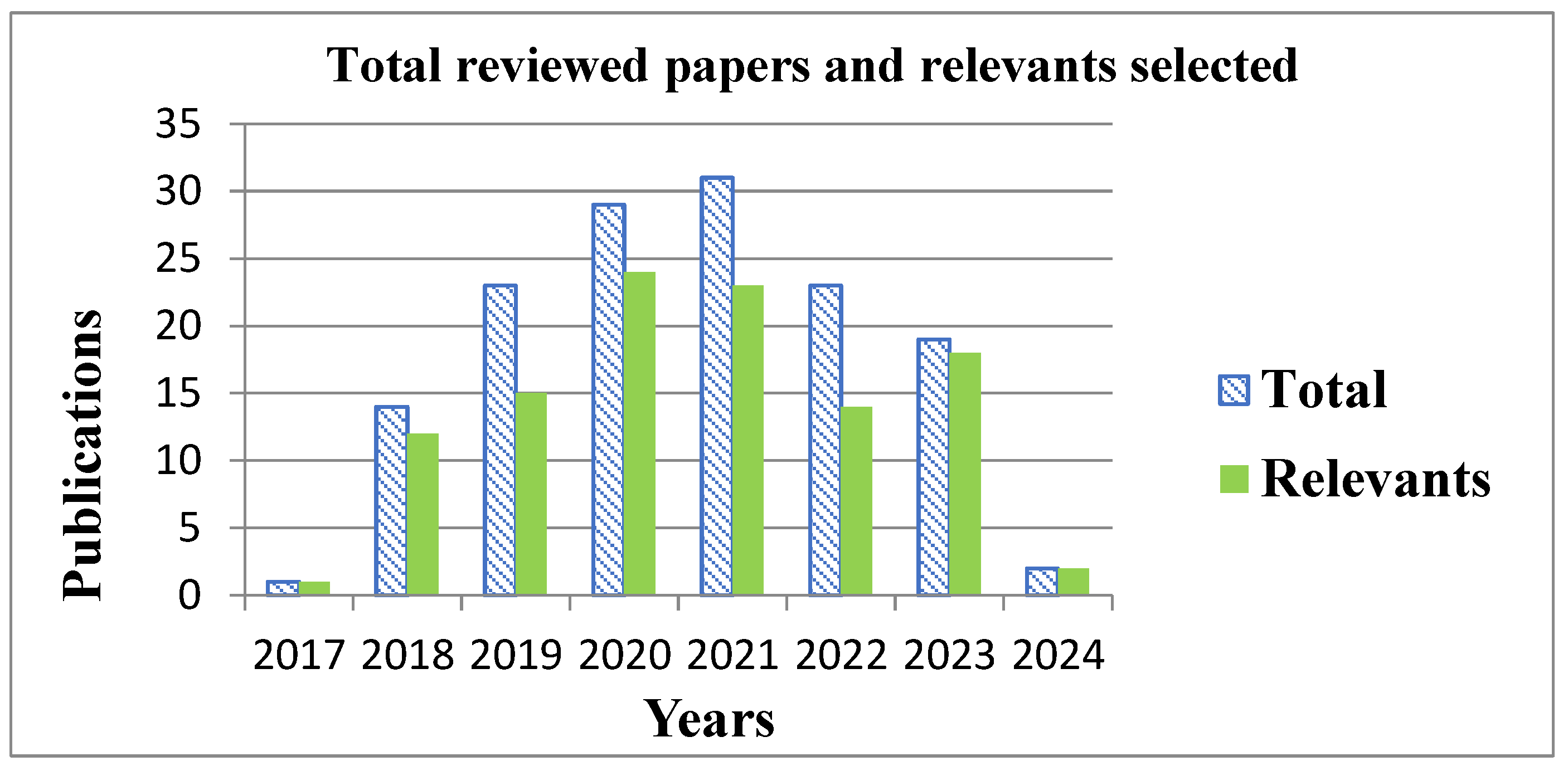
3. Analysis of Trends in the Use of Isotopic and Nuclear Techniques in Water and Land Degradation Research

A traditional literature review was conducted to gain the most comprehensive understanding of the current state of isotopic and nuclear techniques and to propose a hypothesis that integrates the synergistic convergence of these techniques to evaluate soil degradation.
The investigative works by various specialists encompass a range of topics related to soil and water degradation. Additionally, they include an assessment of the feasibility of utilizing isotopic and nuclear techniques for characterizing and evaluating the impacts of these forms of degradation. These works have been referenced and comprise 140 papers published from 2017 to 2024. The 140 publications include 31 works on the current global situation in soil and water degradation and 109 works on the technical application of isotopic and nuclear techniques. The research results provided by this detailed review of the materials allow us to conclude that, currently, these techniques are applied individually and not in an integrated manner.
The selection of research works was based on the timing of their completion. A comprehensive search was conducted for relevant scientific papers across various databases, including the Web of Science, Scopus, the Scientific Electronic Library Online (SciELO), ResearchGate, and Google Scholar. The search for current studies covered the period 2017–2024 and was limited to Spanish- (4) and English-language (136) papers. The objective was to establish research trends by reviewing publications on how researchers approach assessments of the degradation of soil and water sources by applying three nuclear and isotope techniques: FRN, FP, and IH, and related research published in high-impact journals at a global level. The search terms (keywords) were associated with using isotopic and nuclear techniques and environmental phenomena in the landscape. These included isotope hydrology, 18O, 2H (deuterium), fallout radionuclide, 137Cs, 210Pb, 7Be, FP, CSSI, water erosion, integration, sedimentation, land degradation, and other relevant factors.
The search and selection of the analyzed publications were dedicated to obtaining the best representation of the research developed in recent years and covering a wide range of technical and geographical scenarios. This approach was taken for a detailed analysis of the current trends in using nuclear techniques. A total of 109 papers are summarized in Table 1, which shows the distribution of the three techniques analyzed (FRN, FP, and IH) according to the development of their application and their integrative link with other methods.
Because erosion and sedimentation phenomena are intricate processes occurring in the landscape that result in the degradation of both soil and water resources, there is an apparent necessity for the integrated or combined use of the techniques that have been analyzed to gain a deeper understanding of these phenomena and to contribute to developing integrated solutions that will help minimize these forms of degradation. However, as evidenced in Table 1, the integrated application of these techniques is notably limited and they are predominantly used individually. These techniques characterize and address specific forms of degradation, whether soil-related or water-related.
A mere seven research papers demonstrate the joint utilization of the FRN and FP techniques (with CSSI employed as a tracer), two papers illustrate the combination of FRN and IH, and five papers exhibit the comprehensive integration of the three techniques under examination (FRN, FP, and IH). The use of the universal soil loss equations was also examined, with particular attention paid to the necessary modifications that must be made to ensure the fulfillment of current requirements regarding the results that are produced. This review confirmed that the universal equations continue to be applied on a global scale, and three papers demonstrate the use of these equations in combination with the FRN (utilizing the 137Cs tracer to assess soil redistribution in the landscape).
Figure 1 depicts the timings of the selected research works, which were conducted entirely within the period spanning 2017 to 2024. These works are collectively focused on soil and water degradation and the development of three isotopic and nuclear techniques that are instrumental in assessing the sustainable development of these resources. A total of 140 papers are referenced, of which 1 was published in 2017, 14 in 2018, 23 in 2019, 29 in 2020, 31 in 2021, 22 in 2022, 19 in 2023, and 2 in 2024.

3.1. Trends and Perspectives in Isotopic and Nuclear Techniques’ Application in Soil and Water Degradation Assessment
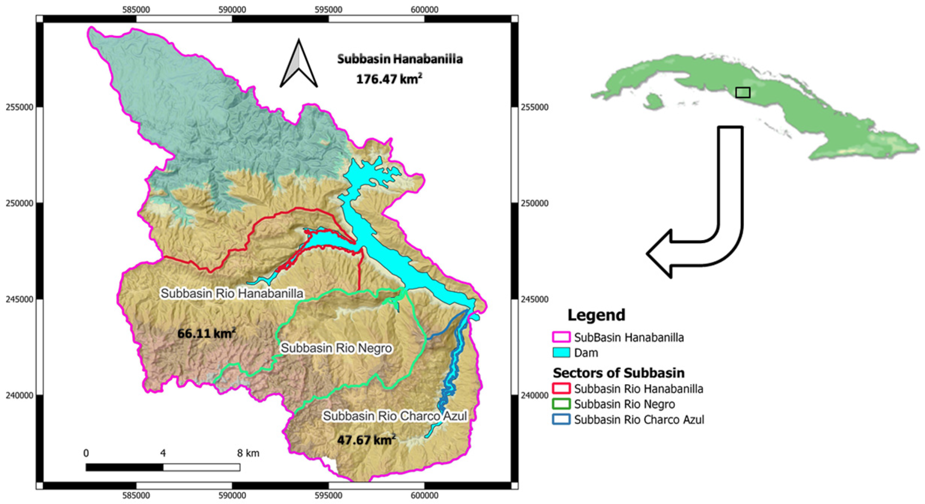
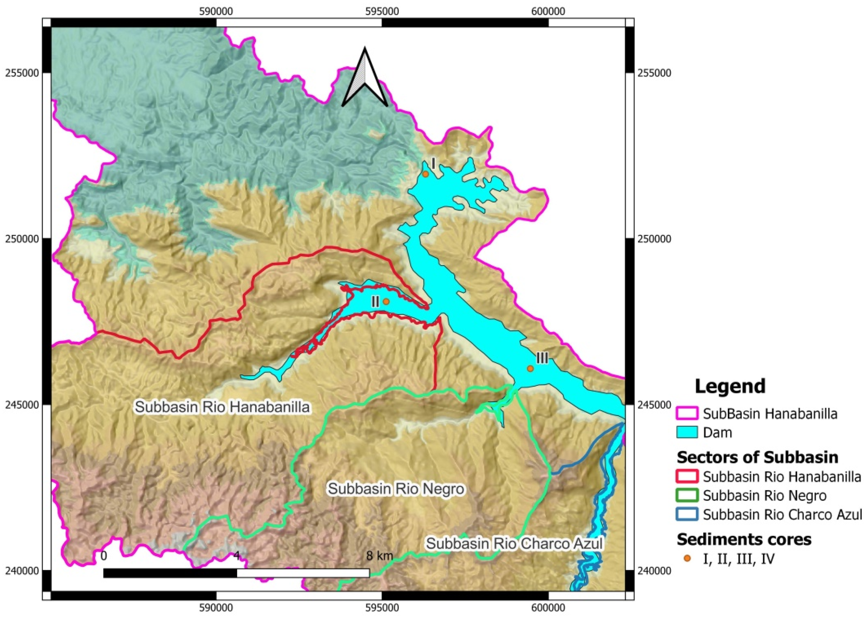
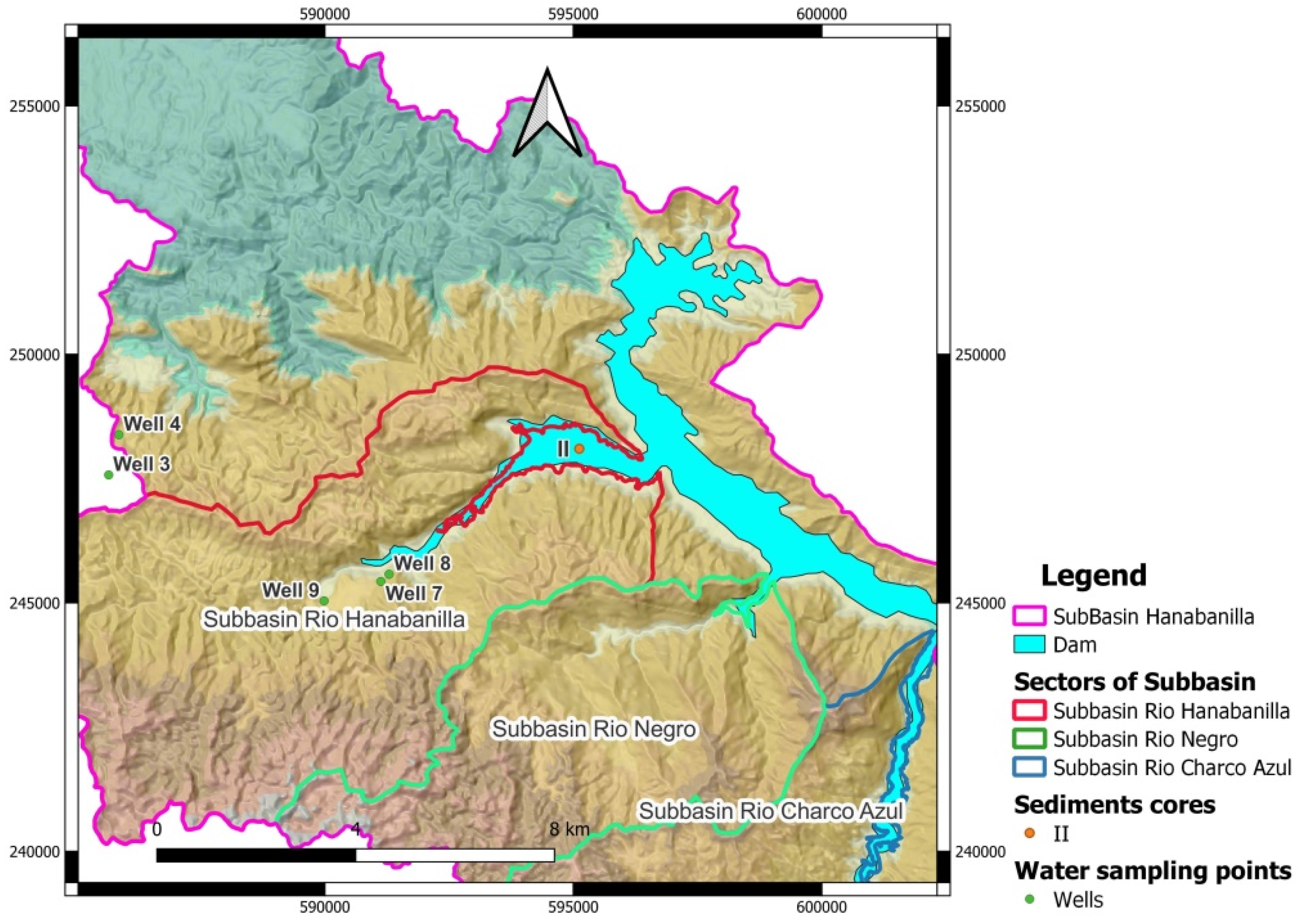
The specific characteristics of each nuclear technique are evident in their application as scientific–technical tools for the characterization and evaluation of environmental variables, namely, water, soil, and sediment. They contribute to the resolution of particular, well-defined problems. Since their inception, the specific use of these techniques without integration has been a worldwide trend for addressing environmental issues related to water, soil, and sediment. Degrading phenomena and their underlying causes have been examined as standalone occurrences without considering the potential for interconnections that could impact multiple environmental variables. Applying these isotopic and nuclear techniques has not been linked to the possible analysis of a sequential process in which one form of degradation could lead to another. The integrated application of the nuclear techniques evaluated in this work would substantially improve the existing deficiencies in the use of tools capable of addressing the effects of climate change and problems regarding the sustainability of land and water conservation. This justifies the search for methodologies capable of providing comprehensive solutions to the problem expressed in the dissimilar national programs that address the issue in countries worldwide [31]. The intricate nature of erosion and sedimentation processes responsible for soil and water degradation necessitates their comprehensive characterization and evaluation. This approach enables the identification of the underlying causes and the implementation of effective mitigation strategies and sustainable management practices.
In the particular case of Latin America and the Caribbean, various investigations have been carried out in the framework of four international projects, RLA5051 (2009–2013), RLA 5064 (2014–2016), RLA 5076 (2018–2021), and CUB 5024 (2022–2024), as well as the development of similar national cases in different countries such as Argentina, Bolivia, Brazil, Chile, Colombia, Cuba, Guatemala, Haiti, Honduras, Mexico, Nicaragua, Panama, Paraguay, Peru, Dominican Republic, Uruguay, and Venezuela. In the last decade, conditions have been created for a change in paradigms and the beginning of the integrated use of isotopic and nuclear techniques (FRN, FP-CSSI, and IH) in a sequential order to obtain more comprehensive solutions to problems linked to sustainability and degradation of terrestrial and aquatic ecosystems [31,76].
The three isotopic and nuclear techniques analyzed offer valuable scientific and technical advantages regarding the results they produce in various applications. However, their integrated use is proposed to leverage these potentialities and achieve optimal effectiveness fully. This approach evaluates the phenomena as processes occurring in the landscape. Furthermore, it suggests a possible use of the synergic convergence of the results obtained and their sequential application. The integration of these techniques allows for the characterization and evaluation of this process, thereby addressing the uncertainties associated with its stages. The redistribution of soil can be attributed to its degradation by water erosion. This process can be analyzed using FRN techniques. Subsequently, the degraded soil is transported and accumulated in the landscape and surface water bodies. The origin of the accumulated soil can be analyzed using CSSI techniques, while IH techniques can characterize the dynamics of the water resources in the study area.

3.2. Case Study

A synthesized example of results obtained in a real case study demonstrates the feasibility of the hypothesis established in this review work.
A crucial hydrographic basin in the central region of Cuba was examined to demonstrate the implementation of an integration methodology combining isotopic and nuclear techniques (FRN, FP, and IH) to evaluate the degradation of land and water resources. In the province of Cienfuegos, within the Hanabanilla hydrographic sub-basin (176.47 km2), two sub-basin sectors were selected for the application of isotopic and nuclear techniques: the “River Hanabanilla” sector (66.11 km2) and the “River Charco Azul” sector (47.67 km2). The region is distinguished by the presence of the Hanabanilla reservoir, which is home to a hydroelectric generation plant. The area comprises sectors with topography characteristics of mountainous regions, featuring elevated slopes, considerable runoff, and water erosion. The study area’s predominant land uses are forestry, protected areas, coffee crops, temporary crops, livestock, and human settlements (Figure 2).
The proposed working hypothesis is that the integration of isotopic and nuclear techniques facilitates the design and implementation of a sampling strategy (in terms of sediment sources and mixtures), supports the interpretation of results, and allows for the quantification of degradation, the identification of causes and sources of degradation, and the assessment of water resource dynamics.
These outcomes are supported by the results obtained from techniques applied in previous stages.
A range of isotopic and nuclear techniques were employed, including FRN (137Cs), FP (CSSI), IH (18O and 2H), and geochemistry of water. Fifty-six samples were analyzed for FRN, twenty-five for FP, and fourteen points for periodic IH sampling, including four sediment cores at the Hanabanilla reservoir’s bottom (points I, II, III, and IV). The initial FRN technique was implemented in both sectors to evaluate soil redistribution. The results obtained from this technique were then considered during the sampling design and the selection of source and mixture points in the landscape. Sequentially, the quantification of the final contributions of the sediments was obtained using FP. Finally, the third technique, IH, was employed with FP to assess the impact of water dynamics (underground, superficial, and reservoir) on the existing sedimentation zones in the Hanabanilla River sector and the sub-basins.
The FP technique was applied differently in the two selected sectors to test the proposed hypothesis. Initially, the FP results were obtained without considering the results of the FRN technique. Subsequently, the FP results were obtained using the FRN soil redistribution data to reinforce the selection of source soil and mixture sediment zones, representing a fundamental stage of the FP technique. The results were evaluated using a range of statistical methods, including the range test, principal component analysis (PCA), goodness of fit of the solution, source contribution graphs, and others, to estimate the relevance of the two application variants with or without integration of FRN data. In the case of the River Hanabanilla sector, three sources were considered in developing the FP technique: forestry, temporary crops, and coffee crops. Additionally, one mixing zone was identified. The tracer was CSSI (carbon chain 14C to 34C), and the FingerPro model [84] was employed to estimate sediment contributions. The results obtained are shown in Table 2.
In the case of the River Charco Azul sector, three sources were considered during the application of the FP technique: forestry, coffee crops, and fruit trees. Additionally, one mixing area was incorporated into the analysis. The tracer was CSSI (carbon chain 14C to 34C), and the FingerPro model, as previously described [78,82], was employed to assess sediment contributions.
Integrating the PCA test with the FRN technique enables the estimation of the contributions of the three sources under consideration. Without integration with FRN, determining the source contributions is challenging due to multiple peaks in the distribution. Exclusion of the fruit tree source contributions facilitates identification of the source contributions. The results are presented in Table 3.
The IH technique, associated with studying the dynamics of surface and underground waters, was applied in the River Hanabanilla sector with periodic measurements of precipitation, wells, springs, and reservoir waters. Isotopic measurements of 18O and 2H were conducted, and the geochemical parameters of the water were analyzed as well, allowing the local isotopic line to be obtained. This process also enabled the identification of phenomena (such as evaporation) that deviate from the isotopic behavior of the local line. The isotopic and geochemical data were collected using the FP technique to analyze the water contributions within the reservoir across the three primary basin sectors within the Hanabanilla sub-basin (River Hanabanilla: point II, River Negro: point III, and Charco Azul: point IV). The sources were identified at the discharge point of each sector, and the mixing was taken at the outlet of the reservoir (point I) (Figure 3).
The initial data’s linear discriminant analysis (LDA) shows significant differences between the evaluated sources (II, III, and IV), validating their use for the FP technique. Point I coincides with the end of the discharge of the waters in the dam (coincident with core I taken at the bottom); this point is where all the seas arrive with their mixtures (final mixture). The final source contributions reveal the River Negro sector as the most crucial source with 78%, followed by the River Charco Azul with 15%, and finally, the River Hanabanilla with 7%. These results are correlated with sedimentation dating studies carried out in the Hanabanilla reservoir, which also show the mouth of the River Negro sector as the source of the most significant contribution of sediments to the reservoir [140].
The integration of the results with this third technique (IH) facilitated a more accurate identification of significant differences between the evaluated sources, enabling their differentiation and providing substantial support for the identification study of sediment contributions (as demonstrated by the FingerPro model through the discriminant analysis conducted on the selected tracers in the investigation). The integrated application of isotopic and nuclear techniques also permitted the incorporation of the FP technique into the hydrogeological study of the case study to analyze mixtures. The water contributions within the River Hanabanilla sector were analyzed from five wells (3, 4, 7, 8, 9) as potential sources. The mixing point was taken at the discharge point of sector II, and a similar tracer was used as in the previous analysis (chemical macro-components, isotopes, and physical–chemical), as illustrated in Figure 4.
In the initial data evaluation, the range test excluded two tracers (total dissolved solids and electric conductivity) suitable for inclusion in the study. The LDA revealed notable distinctions between the evaluated sources and identified partial overlap for wells 7 and 8. The distinct contributions associated with groundwater at the discharge point of the Hanabanilla sector were identified. The wells with the highest contribution, which approaches 75%, are wells 3 and 4 (situated more than 9 km away) and well 9, which account for 25%. The integrated application of isotopic and nuclear techniques (FRN, FP, HI), developed in this study case, enabled a comparison of results, thus identifying the limitations of their individual use and the significant potential of the results provided with their use in an integrated manner (Figure 5). The analysis of soil and water degradation phenomena must consider the various aspects associated with soil redistribution, sedimentation processes, and their relationship with water dynamics. The integrated use of these techniques can significantly enhance the characterization of water and land degradation phenomena, allowing us to evaluate their impacts and formulate strategies for sustainable water and land management.
As illustrated in Figure 5, the sediment contributions for the Rio Hanabanilla sub-basin revealed the forestry sector as the primary source (50%), followed by subsistence crops (40%), and, finally, coffee (10%). The goodness of fit for the mixing model was 0.91, indicating a strong correlation between the observed and predicted values. In the case of the Rio Charco Azul sub-basin, forestry (50%) and subsistence crops (40%) are also primary land uses contributing sediment, while fruit trees (10%) represent the last significant source. The goodness of fit was 0.86. The sedimentation rates associated with each sediment core at the discharge points of each sub-basin within the dam were evaluated. The highest rates were observed in core III (0.24 g/cm2), followed by core IV (0.21 g/cm2). The lowest values were observed in cores II and I, with rates of 0.16 and 0.15 g/cm2, respectively. These findings are corroborated by the aforementioned analysis of source contributions at the reservoir’s final discharge point, which highlights the significance of the Rio Negro and Charco Azul sub-basins as primary sediment sources.

4. Conclusions

The intricate dynamics of erosion and sedimentation processes in landscapes and water reservoirs necessitate a comprehensive characterization and evaluation approach. This entails identifying the underlying causes and implementing sustainable management strategies.
The application of isotopic and nuclear techniques in isolation yields incomplete and uncertain results, thereby constraining the capacity of decision-makers to delineate optimal environmental management strategies.
There is no evidence of an integrative methodology in the use of isotopic and nuclear techniques (FRN, fingerprint, and IH). Furthermore, there is no analysis of a sequential process in which one form of degradation could potentially cause another.
The findings of research conducted in international projects, both completed and ongoing, directed by the authors and funded by the IAEA, illustrate a significant shift in the utilization of isotopic and nuclear techniques (FRN, FP, and IH). These outcomes demonstrate the efficacy of their integrated application sequentially for assessing degradation processes in the landscape.

Author Contributions

Conceptualization, J.L.P.V., F.H.M.L., O.D.R. and R.G.C.; Methodology, J.L.P.V., L.E.C.G., Y.L.P., F.H.M.L., O.D.R. and R.G.C.; Software, J.L.P.V., Y.L.P., F.H.M.L. and R.G.C.; Validation, J.L.P.V., Y.L.P., O.D.R. and R.G.C.; Formal analysis, J.L.P.V., L.E.C.G., Y.L.P., F.H.M.L., O.D.R. and R.G.C.; Investigation, J.L.P.V., L.E.C.G., F.H.M.L., O.D.R. and R.G.C.; Resources, J.L.P.V., L.E.C.G. and R.G.C.; Data curation, J.L.P.V., F.H.M.L. and R.G.C.; Writing—original draft, J.L.P.V., L.E.C.G., Y.L.P., F.H.M.L., O.D.R. and R.G.C.; Writing—review & editing, J.L.P.V., L.E.C.G., F.H.M.L., O.D.R. and R.G.C.; Visualization, J.L.P.V., L.E.C.G., Y.L.P., F.H.M.L., O.D.R. and R.G.C.; Supervision, J.L.P.V., Y.L.P. and R.G.C.; Project administration, J.L.P.V.; Funding acquisition, L.E.C.G. All authors have read and agreed to the published version of the manuscript.

Funding

This work was supported by the Sistema Nacional de Investigación (SNI) of the Secretaría Nacional de Ciencia, Tecnología e Innovación (SENACYT), and the Center for Multidisciplinary Studies in Science, Engineering and Technology AIP (CEMCIT-AIP), Panamá (241-2022).

Institutional Review Board Statement

Not applicable.

Informed Consent Statement

Not applicable.

Data Availability Statement

The original contributions presented in the study are included in the article, further inquiries can be directed to the corresponding author.

Acknowledgments

The authors express their gratitude to all research personnel whose contributions have been instrumental in advancing isotopic and nuclear techniques in environmental variable assessment. Furthermore, the authors acknowledge the contributions of the International Atomic Energy Agency (IAEA) through the Joint Division with the Food and Agriculture Organization (FAO) of the United Nations, which has facilitated the application of nuclear techniques to address challenges in food safety, food security, and sustainable agricultural development for Member States. The Soil and Water Management and Crop Nutrition Subprogram within the Joint FAO/IAEA Division of Nuclear Techniques in Food and Agriculture has made a substantial contribution to the development of isotopic techniques for the assessment of soil degradation. Additionally, our gratitude is extended to the anonymous reviewers whose comments and suggestions enhanced the original manuscript.

Conflicts of Interest

The authors declare no conflict of interest.

References

  1. Ahmadov, E. Water resources management to achieve sustainable development in Azerbaijan. Sustain. Futur. 2020, 2, 100030. [Google Scholar] [CrossRef]
  2. Eekhout, J.P.; de Vente, J. Global impact of climate change on soil erosion and potential for adaptation through soil conservation. Earth-Sci. Rev. 2022, 226, 103921. [Google Scholar] [CrossRef]
  3. Alicia, B.; Luis, S.J.; Wilson, P.; Eduardo, A.J. The Emergency of Climate Change in Latin America and the Caribbean: Do We Continue Waiting for the Catastrophe or do We Take Action? Economic Commission for Latin America and the Caribbean (ECLAC): Santiago, Chile, 2020; ISBN 978-92-1-122031-5 (print ver-sion)/978-92-1-047955-4 (pdf version).
  4. Singh, A.A.; Singh, A.K. Climatic controls on water resources and its management: Challenges and prospects of sustainable development in Indian perspective. In Water Conservation in the Era of Global Climate Change; Elsevier: Amsterdam, The Netherlands, 2021; pp. 121–145. [Google Scholar] [CrossRef]
  5. Kane, I.A.; Clare, M.A. Dispersion, accumulation and the ultimate fate of microplastics in deep marine environments: A review and future directions. Front. Earth Sci. 2019, 7, 80. [Google Scholar] [CrossRef]
  6. Zhu, G.; Yong, L.; Zhang, Z.; Sun, Z.; Wan, Q.; Xu, Y.; Ma, H.; Sang, L.; Liu, Y.; Wang, L.; et al. Effects of plastic mulch on soil water migration in arid oasis farmland: Evidence of stable isotopes. Catena 2021, 207, 105580. [Google Scholar] [CrossRef]
  7. Ameta, S.C. Introduction in Advanced Oxidation Processes for Waste Water Treatment; Academic Press: Cambridge, MA, USA, 2018; pp. 1–12. [Google Scholar] [CrossRef]
  8. Amiri, S.; Mazaheri, M.; Samani, J.M.V. Introducing a general framework for pollution source identification in surface water resources (theory and application). J. Environ. Manag. 2019, 248, 109281. [Google Scholar] [CrossRef]
  9. Ashouri, M.J.; Rafei, M. How do energy productivity and water resources affect air pollution in Iran? New evidence from a Markov Switching perspective. Resour. Policy 2021, 71, 101986. [Google Scholar] [CrossRef]
  10. Chen, H.; Chen, A.; Xu, L.; Xie, H.; Qiao, H.; Lin, Q.; Cai, K. A deep learning CNN architecture applied in smart near-infrared analysis of water pollution for agricultural irrigation resources. Agric. Water Manag. 2020, 240, 106303. [Google Scholar] [CrossRef]
  11. Kumar, S.; Islam, A.R.M.T.; Islam, H.T.; Hasanuzzaman, M.; Ongoma, V.; Khan, R.; Mallick, J. Water resources pollution associated with risks of heavy metals from Vatukoula Goldmine region, Fiji. J. Environ. Manag. 2021, 293, 112868. [Google Scholar] [CrossRef]
  12. Llerena Padrón, Y.; Gil Castillo, R.; Peralta Vital, J.L.; Cordoví Miranda, Y.M.; Bravo Leiva, L.; Fuentes Soto, A. Application of nuclear techniques to estimate soil degradation by erosion, in crops under conservation measures. Nucleus 2022, 54, 54–60. Available online: https://cu-id.com/2157/n72p54 (accessed on 10 January 2024).
  13. López, R.; Hallat, J.; Castro, A.; Miras, A.; Burgos, P. Heavy metal pollution in soils and urban-grown organic vegetables in the province of Sevilla, Spain. Biol. Agric. Hortic. 2019, 35, 219–237. [Google Scholar] [CrossRef]
  14. Carlos Simoes, N.; Kjell, M. Heavy metals, pesticides, polycyclic aromatic hydrocarbons, dyes, and animal waste. In Enzymes in Human and Animal Nutrition: Principles and Perspectives; Elsevier: Amsterdam, The Netherlands, 2018; p. 331. [Google Scholar] [CrossRef]
  15. Santana, C.S.; Olivares, D.M.M.; Silva, V.H.; Luzardo, F.H.; Velasco, F.G.; de Jesus, R.M. Assessment of water resources pollution associated with mining activity in a semi-arid region. J. Environ. Manag. 2020, 273, 111148. [Google Scholar] [CrossRef] [PubMed]
  16. Zabaloy, M.C. One Health: Soil health and its link with human health. Rev. Argent. Microbiol. 2021, 53, 275–276. [Google Scholar] [CrossRef] [PubMed]
  17. Zinck, J.A. , Metternicht, G., Del Valle, H.F., Angelini, M. Geopedology: An Integration of Geomorphology and Pedology for Soil and Landscapes Studies, 2nd ed.; Springer Nature: Cham, Switzerland, 2023; ISBN 978-3-031-20667-2. [Google Scholar]
  18. Moorberg Colby, J.; Crouse David, A. Soils Laboratory Manual: K. State Edition, Version 2.0. NPP eBooks. 39. 2021. Available online: https://newprairiepress.org/ebooks/39 (accessed on 17 May 2023).
  19. UN. Program for the environment. Historic decision: The UN declares that a healthy environment is a human right. In Reportage. Rights and Environmental Governance; UN: Nairobi, Kenya, 2022. [Google Scholar]
  20. UN-UNEP. Evaluation reports on diverse values the valuation of nature. In Intergovernmental Scientific-Policy Platform on Biological Diversity and Ecosystem Services (IPBES); UN-UNEP: Nairobi, Kenya, 2022. [Google Scholar]
  21. Bouma, J.; de Haan, J.; Dekkers, M.-F.S. Exploring Operational Procedures to Assess Ecosystem Services at Farm Level, including the Role of Soil Health. Soil Syst. 2022, 6, 34. [Google Scholar] [CrossRef]
  22. FAO. The state of the world’s land and water resources for food and agriculture- systems on the limit. In Synthesis Report; FAO: Rome, Italy, 2021. [Google Scholar] [CrossRef]
  23. FAO. The importance of soil health for a sustainable Agri-food Systems within the framework of One Health. In Proceedings of the Global Soil Partnership, 11th Plenary assembly, Rome, Italy, 12–14 July 2023. [Google Scholar]
  24. Hussain, Z.; Deng, L.; Wang, X.; Cui, R.; Liu, G. A Review of Farmland Soil Health Assessment Methods: Current Status and a Novel Approach. Sustainability 2022, 14, 9300. [Google Scholar] [CrossRef]
  25. WWF. Living Planet Report 2022. In Building a Nature-Positive Society; Almond, R.E.A., Grooten, M., Juffe Bignoli, D., y Petersen, T., Eds.; WWF: Gland, Switzerland, 2022; ISBN 978-2-88085-316-7. [Google Scholar]
  26. Kendzior, J.; Warren Raffa, D.; Bogdanski, A. The Soil Microbiome: A Game Changer for Food and Agriculture-Executive Summary for Policymakers and Researchers; FAO: Rome, Italy, 2022. [Google Scholar] [CrossRef]
  27. Aguirre-Salado, O.T.; Pérez-Nieto, J.; Aguirre-Salado, C.A.; Monterroso-Rivas, A.I.; Gallardo-Lancho, J.F. Water erosion, soil organic carbon redistribution and soil and water conservation: A review. Rev. Chapingo Ser. Cienc. For. Ambient. 2023, 29, 47–60. [Google Scholar] [CrossRef]
  28. Golosov, V.; Walling, D.E. Erosion and Sediment Problems: Global Hotspots; UNESCO: Paris, France, 2019; Volume 7, p. 75352. [Google Scholar]
  29. Mabit, L.; Bernard, C.; Yi, A.L.Z.; Fulajtar, E.; Dercon, G.; Zaman, M.; Toloza, A.; Heng, L. Promoting the use of isotopic techniques to combat soil erosion: An overview of the key role played by the SWMCN Subprogramme of the join FAO/IAEA Division over the last 20 years. Land Degrad. Dev. 2018, 29, 3077–3091. [Google Scholar] [CrossRef]
  30. Valdivielso, S.; Vázquez-Suñé, E.; Custodio, E. Isotopía ambiental de las precipitaciones y de las aguas superficiales y subterráneas en los Andes Centrales: Revisión. Boletin Geol. Y Min. 2021, 132, 147–156. [Google Scholar] [CrossRef]
  31. Vital, J.L.P.; Gil Castillo, R.H.; Padrón, Y.L.; Miranda, Y.M.C.; Arevalo, N.L.; Pino, L.A. Integrated nuclear techniques for sedimentation assessment in Latin American region. Int. Soil Water Conserv. Res. 2020, 8, 406–409. [Google Scholar] [CrossRef]
  32. Sivasankar, S.; Heng, L.K.; Kang, S.-Y. Agriculture: Improving Crop Production. 2021, pp. 290–301. Available online: https://www.sciencedirect.com/science/article/abs/pii/B9780124095489123231?via%3Dihub (accessed on 23 September 2024).
  33. Ghosal, K.; Das Bhattacharya, S. A review of RUSLE Model. J. Indian Soc. Remote Sens. 2020, 48, 689–707. [Google Scholar] [CrossRef]
  34. Benavidez, R.; Jackson, B.; Maxwell, D.; Norton, K. Una revisión de la ecuación universal de pérdida de suelo (revisada) ((R)(USLE): Con miras a aumentar su aplicabilidad global y mejorar las estimaciones de perdida de suelo. Hydrol. Earth Syst. Sci. 2018, 22, 6059–6086. [Google Scholar] [CrossRef]
  35. Yoon, J.-H.; Kim, Y.-N.; Kim, K.-H.; Kirkham, M.B.; Kim, H.S.; Yang, J.E. Use of 137Cs and 210Pbex fallout radionuclides for spatial soil erosion and redistribution assessment on steeply sloping agricultural highlands. J. Mt. Sci. 2021, 18, 2888–2899. [Google Scholar] [CrossRef]
  36. Valdivia-Martínez, O.; Peña-Uribe, G.d.J.; Rufino-Rodríguez, F.; Torres-González, J.A.; Meraz-Jiménez, A.d.J.; López-Santos, A. Adjustment of the Universal Soil Loss Equation in runoff plots located in a region of central Mexico. Rev. Terra Latinoam. 2022, 40, e990. [Google Scholar] [CrossRef]
  37. Yigez, B.; Xiong, D.; Zhang, B.; Yuan, Y.; Baig, M.A.; Dahal, N.M.; Guadie, A.; Zhao, W.; Wu, Y. Spatial distribution of soil erosion and sediment yield in the Koshi River Basin, Nepal: A case study of Triyuga watershed. J. Soils Sediments 2021, 21, 3888–3905. [Google Scholar] [CrossRef]
  38. Yigez, B.; Xiong, D.; Zhang, B.; Belete, M.; Chalise, D.; Chidi, C.L.; Guadie, A.; Wu, Y.; Rai, D.K. Dynamics of soil loss and sediment export as affected by land use/cover change in Koshi River Basin, Nepal. J. Geogr. Sci. 2023, 33, 1287–1312. [Google Scholar] [CrossRef]
  39. Fang, H. Changes in cultivated land area and associated soil and soil organic carbon losses in Northeastern China: The role of land use policies. Int. J. Environ. Res. Public Health 2021, 18, 11314. [Google Scholar] [CrossRef]
  40. Yeneneh, N.; Elias, E.; Feyisa, G.L. Quantify soil erosion and sediment export in response to land use/cover change in the Suha watershed, northwestern highlands of Ethiopia: Implications for watershed management. Environ. Syst. Res. 2022, 11, 20. [Google Scholar] [CrossRef]
  41. Stefanidis, S.; Alexandridis, V.; Ghosal, K. Assessment of Water-Induced Soil Erosion as a Threat to Natura 2000 Protected Areas in Crete Island, Greece. Sustainability 2022, 14, 2738. [Google Scholar] [CrossRef]
  42. Arias-Muñoz, P.; Saz, M.A.; Escolano, S. Estimación de la erosión del suelo mediante el modelo RUSLE. Caso de estudio: Cuenca media alta del río Mira en los Andes de Ecuador. Investig. Geogr. 2023, 79, 207–230. [Google Scholar] [CrossRef]
  43. Jaya-Santillán, J. Altos niveles de erosión hídrica en una microcuenca tropical calculado mediante el modelo USLE. FIGEMPA Investig. Y Desarro. 2023, 15, 26–39. [Google Scholar] [CrossRef]
  44. Ayele, M.A.; Ayalew, A.T. Modeling of watershed intervention techniques to rehabilitate sediment yield hotspot areas in Hare watershed, rift valley basin, Ethiopia. Model. Earth Syst. Environ. 2023, 10, 425–441. [Google Scholar] [CrossRef]
  45. Brandt, C.; Benmansour, M.; Walz, L.; Nguyen, L.T.; Cadisch, G.; Rasche, F. Integrating compound-specific δ13C isotopes and fallout radionuclides to retrace land use type-specific net erosion rates in a small tropical catchment exposed to intense land use change. Geoderma 2018, 310, 53–64. [Google Scholar] [CrossRef]
  46. Mabit, L.; Gibbs, M.; Mbaye, M.; Meusburger, K.; Toloza, A.; Resch, C.; Klik, A.; Swales, A.; Alewell, C. Novel application of compound specific stable isotope (CSSI) techniques to investigate on-site sediment origins across arable fields. Geoderma 2018, 316, 19–26. [Google Scholar] [CrossRef]
  47. Velasco, H.; Astorga, R.T.; Joseph, D.; Antoine, J.; Mabit, L.; Toloza, A.; Dercon, G.; Walling, D.E. Adapting the Caesium-137 technique to document soil redistribution rates associated with traditional cultivation practices in Haiti. J. Environ. Radioact. 2018, 183, 7–16. [Google Scholar] [CrossRef]
  48. Vanesa, T.A.R. Use of Nuclear and Associated Technique to Document Soil Redistribution Processes and Identify the Main Sources of Sediments in a Hydrographic Basin in the Central Region of Argentina. Master’s Thesis, National University of San Luis. Conicet, San Luis, Argentina, 29 March 2019. Available online: http://hdl.handle.net/11336/81130 (accessed on 23 September 2024).
  49. Khodadadi, M.; Mabit, L.; Zaman, M.; Porto, P.; Gorji, M. Using 137Cs and 210Pbex measurements to explore the effectiveness of soil conservation measures in semi-arid lands: A case study in the Kouhin region of Iran. J. Soils Sediments 2019, 19, 2103–2113. [Google Scholar] [CrossRef]
  50. Mabit, L.; Blake, W.; Taylor, A.; Iurian, A.; Millwa, G.; Toloza, A.; Benmansour, M. Assessing Recent Soil Erosion Rates through the Use of Beryllium-7 (Be-7); Mabel, L., Blake, W., Eds.; Springer Open: Cham, Switzerland, 2019. [Google Scholar] [CrossRef]
  51. La Manna, L.; Gaspar, L.; Tarabini, M.; Quijano, L.; Navas, A. 137Cs inventories along a climatic gradient in volcanic soils of Patagonia: Potential use for assessing medium term erosion processes. Catena 2019, 181, 104089. [Google Scholar] [CrossRef]
  52. Gaspar, L.; Quijano, L.; Lizaga, I.; Navas, A. Effects of land use on soil organic and inorganic C and N at 137Cs traced erosional and depositional sites in mountain agroecosystems. Catena 2019, 181, 104058. [Google Scholar] [CrossRef]
  53. Gaspar, L.; Mabit, L.; Lizaga, I.; Navas, A. Lateral mobilization of soil carbon induced by runoff along karstic slopes. J. Environ. Manag. 2020, 260, 110091. [Google Scholar] [CrossRef]
  54. Gaspar, L.; Lizaga, I.; Navas, A. Spatial distribution of fallout and lithogenic radionuclides controlled by soil carbon and water erosion in an agroforestry South-Pyrenean catchment. Geoderma 2021, 391, 114941. [Google Scholar] [CrossRef]
  55. Khodadadi, M.; Zaman, M.; Mabit, L.; Blake, W.H.; Gorji, M.; Bahrami, A.S.; Meftahi, M.; Porto, P. Exploring the potential of using 7Be measurements to estimate soil redistribution rates in semi-arid areas: Results from Western Iran and Southern Italy. J. Soils Sediments 2020, 20, 3524–3536. [Google Scholar] [CrossRef]
  56. Gharibreza, M.; Zaman, M.; Porto, P.; Fulajtar, E.; Parsaei, L.; Eisaei, H. Assessment of deforestation impact on soil erosion in loess formation using 137Cs method (case study: Golestan Province, Iran). Int. Soil Water Conserv. Res. 2020, 8, 393–405. [Google Scholar] [CrossRef]
  57. Gaspar, L.; Lizaga, I.; Navas, A. Elemental mobilisation by sheet erosion affected by soil organic carbon and water fluxes along a radiotraced soil catena with two contrasting parent materials. Geomorphology 2020, 370, 107387. [Google Scholar] [CrossRef]
  58. Su, Z.A.; Zhou, T.; Zhang, X.B.; Wang, X.Y.; Wang, J.J.; Zhou, M.H.; Zhang, J.; He, Z.; Zhang, R. A preliminary study of the impacts of shelter forest on soil erosion in cultivated land: Evidence from in-tegrated 137Cs and 210Pb measurements. Soil Tillage Res. 2021, 206, 104843. [Google Scholar] [CrossRef]
  59. Foucher, A.; Chaboche, P.-A.; Sabatier, P.; Evrard, O. A worldwide meta-analysis (1977-2020) of sediment core dating using fallout radionuclides including 137Cs and 210Pbxs. Earth Syst. Sci. Data 2021, 13, 4951–4966. [Google Scholar] [CrossRef]
  60. Villuendas, I.L.; Latorre, B.; Gaspar, L.; Navas, A. Effect of historical land-use change on soil erosion in a Mediterranean catchment by integrating 137Cs measurements and WaTEM/SEDEM model. Hydrol. Process. 2022, 36, e14577. [Google Scholar] [CrossRef]
  61. Lizaga, I.; Latorre, B.; Gaspar, L.; Navas, A. Combined use of geochemistry and compound-specific stable isotopes for sediment fingerprinting and tracing. Sci. Total. Environ. 2022, 832, 154834. [Google Scholar] [CrossRef]
  62. Houshia, O.; Benmansour, M.; Mabit, L.; Fulajtár, E.; Abu-Jabal, S.; Hroub, I.; Odeh, R. Comparing soil erosion rates on terraced and sloping cultivated land in Palestine using FRN 137Cs trace. Int. J. Anal. Chem. 2022, 2022, 2933661. [Google Scholar] [CrossRef]
  63. Iaaich, H.; Moussadek, R.; Mrabet, R.; Douaik, A.; Baghdad, B.; Benmansour, M.; Zouagui, A.; Asserar, N.; Bouabdli, A. Evaluation of the impact of No-Till on Soil Erosion Using Soil Aggregate Stability and Fallout Radionuclides in Northern Morocco. Ecol. Eng. Environ. Technol. 2023, 24, 241–248. [Google Scholar] [CrossRef]
  64. Porto, P.; Callegari, G. Relating 137Cs and sediment yield from uncultivated catchments: The role of particle size composition of soil and sediment in calculating soil erosion rates at the catchment scale. J. Soils Sediments 2023, 23, 3689–3705. [Google Scholar] [CrossRef]
  65. Khorchani, M.; Gaspar, L.; Nadal-Romero, E.; Arnaez, J.; Lasanta, T.; Navas, A. Effects of cropland abandonment and afforestation on soil redistribution in a small Mediterranean mountain catchment. Int. Soil Water Conserv. Res. 2023, 11, 339–352. [Google Scholar] [CrossRef]
  66. Gharibreza, M.; Zaman, M.; Rabesiranana, N.; Fulajtar, E.; Mahmoudi, M. Using 137Cs tracer to assess the effects of silvicultural systems on soil redistribution in Hyrcanian forest, Mazandaran—Iran. Eur. J. For. Res. 2023, 143, 205–218. [Google Scholar] [CrossRef]
  67. Kumar, S.; Raj, A.D.; Mariappan, S. Fallout radionuclides (FRNs) for measuring soil erosion in the Himalayan region: A versatile and potent method for steep sloping hilly and mountainous landscapes. Catena 2024, 234, 107591. [Google Scholar] [CrossRef]
  68. Cabrera, M.; Sanabria, R.; González, J.; Cabral, P.; Tejeda, S.; Zarazua, G.; Melgar-Paniagua, E.; Tassano, M. Using 137Cs and 210Pbex to assess soil redistribution at different temporal scales along with lithogenic radionuclides to evaluate contrasted watersheds in the Uruguayan Pampa grassland. Geoderma 2023, 435, 116502. [Google Scholar] [CrossRef]
  69. Wang, Z.; Zhang, Y.; Govers, G.; Tang, G.; Quine, T.A.; Qiu, J.; Navas, A.; Fang, H.; Tan, Q.; Van Oost, K. Temperature effect on erosion-induced disturbances to soil organic carbon cycling. Nat. Clim. Chang. 2023, 13, 174–181. [Google Scholar] [CrossRef]
  70. Gaspar, L.; Franz, T.E.; Catalá, A.; Lizaga, I.; Ramos, M.C.; Navas, A. Combining cosmic-ray neutron sensor and fallout 137Cs to explore the connection of soil water content with soil redistribution in an agroforestry hillslope. Environ. Res. 2023, 233, 116451. [Google Scholar] [CrossRef]
  71. Hirave, P.; Nelson, D.B.; Glendell, M.; Alewell, C. Land-use-based freshwater sediment source fingerprinting using hydrogen isotope compositions of long-chain fatty acids. Sci. Total. Environ. 2023, 875, 162638. [Google Scholar] [CrossRef]
  72. Hirave, P. Freshwater Sediment Source Fingerprinting Using Compound-Specific Isotope Analysis: Suitability and Application. Ph.D. Thesis, University of Basel, Faculty of Science, Basel, Switzerland, 2023; p. 14935. Available online: https://edoc.unibas.ch/92509/ (accessed on 9 November 2023). [CrossRef]
  73. Huangfu, Y.; Essington, M.E.; Hawkins, S.A.; Walker, F.R.; Schwartz, J.S.; Layton, A.C. Testing the sediment fingerprinting technique using the SIAR model with artificial sediment mixtures. J. Soils Sediments 2020, 20, 1771–1781. [Google Scholar] [CrossRef]
  74. Bravo-Linares, C.; Schuller, P.; Castillo, A.; Ovando-Fuentealba, L.; Muñoz-Arcos, E.; Alarcón, O.; de los Santos-Villalobos, S.; Cardoso, R.; Muniz, M.; dos Anjos, R.M.; et al. First use of a compound-specific stable isotope (CSSI) technique to trace sediment transport in upland forest catchments of Chile. Sci. Total Environ. 2018, 618, 1114–1124. [Google Scholar] [CrossRef]
  75. Gaspar, L.; Lizaga, I.; Blake, W.H.; Latorre, B.; Quijano, L.; Navas, A. Fingerprinting changes in source contribution for evaluating soil response during an exceptional rainfall in Spanish pre-pyrenees. J. Environ. Manag. 2019, 240, 136–148. [Google Scholar] [CrossRef]
  76. Brandt, C.; Dercon, G.; Cadisch, G.; Nguyen, L.T.; Schuller, P.; Linares, C.B.; Santana, A.C.; Golosov, V.; Benmansour, M.; Amenzou, N.; et al. Towards global applicability? Erosion source discrimination across catchments using compound-specific δ13C isotopes. Agric Ecosyst Environ. 2018, 256, 114–122. [Google Scholar] [CrossRef]
  77. Vital, J.L.P.; Calvo, L.; Gil, R.; Padrón, Y.L.; Broce, K.; Franco-Ábrego, A.K. Application of the Compound-Specific Stable Isotopes (CSSI) Technique to Evaluate the Contributions of Sediment Sources in the Panama Canal Watershed. Appl. Sci. 2023, 13, 11736. [Google Scholar] [CrossRef]
  78. Lizaga, I.; Latorre, B.; Gaspar, L.; Navas, A. Consensus ranking as a method to identify non-conservative and dissenting tracers in fingerprinting studies. Sci. Total. Environ. 2020, 720, 137537. [Google Scholar] [CrossRef]
  79. Latorre, B.; Gaspar, L.; Lizaga, I.; Navas, A. A novel method for analysing consistency and unravelling multiple solutions in sediment fingerprinting. Sci. Total. Environ. 2021, 789, 147804. [Google Scholar] [CrossRef]
  80. Gaspar, L.; Blake, W.H.; Smith, H.G.; Lizaga, I.; Navas, A. Testing the sensitivity of a multivariate mixing model using geochemical fingerprints with artificial mixtures. Geoderma 2018, 337, 498–510. [Google Scholar] [CrossRef]
  81. Gaspar, L.; Blake, W.H.; Lizaga, I.; Latorre, B.; Navas, A. Particle size effect on geochemical composition of experimental soil mixtures relevant for unmixing modelling. Geomorphology 2022, 403, 108178. [Google Scholar] [CrossRef]
  82. Lizaga, I.; Gaspar, L.; Latorre, B.; Navas, A. Variations in transport of suspended sediment and associated elements induced by rainfall and agricultural cycle in a Mediterranean agroforestry catchment. J. Environ. Manag. 2020, 272, 111020. [Google Scholar] [CrossRef]
  83. Lizaga, I.; Gaspar, L.; Blake, W.H.; Latorre, B.; Navas, A. Fingerprinting changes of source apportionments from mixed land uses in stream sediments before and after an exceptional rainstorm event. Geomorphology 2019, 341, 216–229. [Google Scholar] [CrossRef]
  84. Lizaga, I.; Latorre, B.; Gaspar, L.; Navas, A. FingerPro: An R Package for Tracking the Provenance of Sediment. Springer Nature B.V. Water Resour. Manag. 2020, 34, 3879–3894. [Google Scholar] [CrossRef]
  85. Lizaga, I.; Latorre, B.; Bodé, S.; Gaspar, L.; Boeckx, P.; Navas, A. Combining isotopic and elemental tracers for enhanced sediment source partitioning in complex catchments. J. Hydrol. 2024, 631, 130768. [Google Scholar] [CrossRef]
  86. Lizaga, I.; Bodé, S.; Gaspar, L.; Latorre, B.; Boeckx, P.; Navas, A. Legacy of historic land cover changes on sediment provenance tracked with isotopic tracers in a Mediterranean agroforestry catchment. Sci. Total. Environ. 2021, 288, 112291. [Google Scholar] [CrossRef] [PubMed]
  87. Navas, A.; Lizaga, I.; Gaspar, L.; Latorre, B.; Dercon, G. Unveiling the provenance of sediments in the moraine complex of Aldegonda Glacier (Svalbard) after glacial retreat using radionuclides and elemental fingerprints. Geomorphology 2020, 367, 107304. [Google Scholar] [CrossRef]
  88. Navas, A.; Lizaga, I.; Santillán, N.; Gaspar, L.; Latorre, B.; Dercon, G. Targeting the source of fine sediment and associated geochemical elements by using novel fingerprinting methods in proglacial tropical highlands (Cordillera Blanca, Perú). Hydrol. Process. 2022, 36, e14662. [Google Scholar] [CrossRef]
  89. Gibbs, M.; Leduc, D.; Nodder, S.D.; Kingston, A.; Swales, A.; Rowden, A.A.; Mountjoy, J.; Olsen, G.; Ovenden, R.; Brown, J.; et al. Novel application of a Compound-Specific Stable Isotope (CSSI) tracking technique demonstrates connectivity between terrestrial and deep-sea ecosystems via submarine canyons. Front. Mar. Sci. 2020, 7, 608. [Google Scholar] [CrossRef]
  90. Mabit, L.; Mbaye, M.; Toloza, A.; Gibbs, M.; Swales, A.; Strauss, P. Use of soil organic biomarkers for tracing the origin of eroded sediment: Case study in Petzenkirchen (Austria). In Proceedings of the EGU General Assembly, Online, 4–8 May 2020; p. EGU2020-2014. [Google Scholar] [CrossRef]
  91. Bravo-Linares, C.; Schuller, P.; Castillo, A.; Salinas-Curinao, A.; Ovando-Fuentealba, L.; Muñoz-Arcos, E.; Swales, A.; Gibbs, M.; Dercon, G. Combining Isotopic Techniques to Assess Historical Sediment Delivery in a Forest Catchment in Central Chile. J. Soil Sci. Plant Nutr. 2019, 20, 83–94. [Google Scholar] [CrossRef]
  92. IAEA-TECDOC-1881; Guidelines for Sediment Tracing Using the Compound Specific Carbon Stable Isotope Technique. Joint FAO/IAEA (2019). Soil and Water Management and Crop Nutrition Section. International Atomic Energy Agency: Vienna, Austria, 2019; ISBN 978-920-158519-6/978-92-0-158619-3 (pdf). ISSN 1011-4289.
  93. Hirave, P.; Glendell, M.; Birkholz, A.; Alewell, C. Compound-specific isotope analysis with nested sampling approach detects spatial and temporal variability in the sources of suspended sediments in a Scottish mesoscale catchment. Sci. Total. Environ. 2020, 755, 142916. [Google Scholar] [CrossRef]
  94. Ayala-Zepeda, M.; Díaz-Rodríguez, A.M.; Cardoso, R.; Muniz, M.C.; Torres-Astorga, R.; Bravo-Linares, C.; dos Anjos, R.M.; Velasco, H.; Tejeda-Vega, S.; de los Santos-Villalobos, S. Compound-specific stable isotopes for the estimation of soil redistribution by erosive events. Rev. Agrociencia 2020, 54, 601–618. [Google Scholar]
  95. Li, N.; Zhang, Y.; Sun, Z.; Yang, J.; Liu, E.; Li, C.; Li, F. Tracking the deposition and sources of soil carbon and nitrogen in highly eroded hilly-gully watershed in Northeastern China. Int. J. Environ. Res. Public Health 2021, 18, 2971. [Google Scholar] [CrossRef]
  96. Winterová, J.; Krása, J.; Bauer, M.; Noreika, N.; Dostál, T. Using WaTEM/SEDEM to Model the effects of crop rotation and changes in land use on sediment transport in the Vrchlice watershed. Sustainability 2022, 14, 5748. [Google Scholar] [CrossRef]
  97. Atwell, A.K.; Bouldin, J.L. Effects of agricultural intensity on nutrient and sediment contributions within the cache river watershed, arkansas. Water 2022, 14, 2528. [Google Scholar] [CrossRef]
  98. Daramola, J.; Adepehin, E.J.; Ekhwan, T.M.; Choy, L.K.; Mokhtar, J.; Tabiti, T.S. Impacts of Land-use change, associated land-use area and runoff on watershed sediment yield: Implications from the Kaduma watershed. Water 2022, 14, 325. [Google Scholar] [CrossRef]
  99. Lizaga, I.; Quijano, L.; Palazón, L.; Gaspar, L.; Navas, A. Enhancing connectivity index to assess the effects of land use changes in a Mediterranean catchment. Land Degradation and Development. Land Degrad. Dev. 2018, 29, 663–675. [Google Scholar] [CrossRef]
  100. Rojas, J.G.O. Analysis of Vegetation Cover in the Upper and Middle Paraguay River Basin and Its Influ-Ence on Hydrological Variables between the Years 2002–2019. Master’s Thesis, Faculty of Engineering. National University of Asunción, San Lorenzo, Paraguay, August 2022. [Google Scholar]
  101. Marchesini, V.A.; Nosetto, M.D.; Houspanossian, J.; Jobbágy, E.G. Contrasting hydrological seasonality with latitude in the South American Chaco: The roles of climate and vegetation activity. J. Hydrol. 2020, 587, 124933. [Google Scholar] [CrossRef]
  102. Wang, Y.; Yang, F.; Qi, S.; Cheng, J. Estimating the effect of rain splash on soil particle transport by using a modified model: Study on short hillslopes in Northern China. Water 2020, 12, 2318. [Google Scholar] [CrossRef]
  103. Craig, M.J.; Baas, J.H.; Amos, K.J.; Strachan, L.J.; Manning, A.J.; Paterson, D.M.; Hope, J.A.; Nodder, S.D.; Baker, M.L. Biomediation of submarine sediment gravity flow dynamics. Geology 2019, 48, 72–76. [Google Scholar] [CrossRef]
  104. Kieta, K.; Owens, P.; Petticrew, E. Evaluating and improving the assessment of compound-specific stable isotope derived sediment fingerprinting results in an agricultural watershed in British Columbia, Canada. Catena 2024, 246, 108351. [Google Scholar] [CrossRef]
  105. IAEA. Global Network of Isotopes in Precipitation. The GNIP Database. 2019. Available online: https://www.iaea.org/services/networks/gnip (accessed on 11 December 2023).
  106. Le, B.T. Application of deep learning and near infrared spectroscopy in cereal analysis. Vib. Spectrosc. 2019, 106, 103009. [Google Scholar] [CrossRef]
  107. Bicalho, C.; Batiot-Guilhe, C.; Taupin, J.; Patris, N.; Van Exter, S.; Jourde, H. A conceptual model for groundwater circulation using isotopes and geochemical tracers coupled with hydrodynamics: A case study of the Lez karst system, France. Chem. Geol. 2019, 528, 118442. [Google Scholar] [CrossRef]
  108. IAEA Bulletin. (a). Lucia Ortega, Laura Gil. Overview of Isotopic Hydrology. Article from the IAEA Bulletin. Department of Nuclear Sciences and Applications. IAEA Bulletin “Water”. April 2019, Volume 60-1. Available online: https://www.iaea.org/sites/default/files/publications/magazines/bulletin/bull60-1/6010405_corr.pdf (accessed on 10 March 2024).
  109. IAEA Bulletin. (b). Yukiyama Amano. Understanding the World’s Water Resources. IAEA Bulletin “Water”. April 2019, Volume 60-1. Available online: https://www.iaea.org/sites/default/files/publications/magazines/bulletin/bull60-1/6010101_corr.pdf (accessed on 25 September 2023).
  110. Saleh, H.M.; Hassan, A.I. Water chemistry in the biological studies by using nuclear analytical techniques. In Water Engineering Modeling and Mathematic Tools; Elsevier: Amsterdam, The Netherlands, 2021; pp. 133–156. [Google Scholar] [CrossRef]
  111. Tweed, S.; Leblanc, M.; Cartwright, I.; Bass, A.; Travi, Y.; Marc, V.; Nguyen Bach, T.; Dang Duc, N.; Massuel, S.; Kumar, U.S. Stable Isotopes of Water in Hydrogeology; Hydrology, Groundwater, and Surface Water: Hoboken, NJ, USA, 2020. [Google Scholar] [CrossRef]
  112. Chen, Y.; Tian, L. Canal surface evaporation along the China’s South-to-North Water Diversion quantified by water isotopes. Sci. Total. Environ. 2021, 779, 146388. [Google Scholar] [CrossRef]
  113. Bailey-Serres, J.; Parker, J.E.; Ainsworth, E.A.; Oldroyd, G.E.D.; Schroeder, J.I. Genetic strategies for improving crop yields. Nature 2019, 575, 109–118. [Google Scholar] [CrossRef]
  114. Sharpley, A.N. Agriculture, Nutrient Management and Water Quality. Ref. Modul. Life Sci. 2018, 2013, 95–110. [Google Scholar] [CrossRef]
  115. Langridge, R.; Fencl, A. Implications of Climate Change to Groundwater. Encycl. World’s Biomes 2020, 4, 438–453. [Google Scholar] [CrossRef]
  116. Kpegli, K.A.R.; Alassane, A.; van der Zee, S.E.; Boukari, M.; Mama, D. Devel-opment of a conceptual groundwater flow model using a combined hydrogeological, hydrochemical and isotopic approach: A case study from southern Benin. J. Hydrol. Reg. Stud. 2018, 18, 50–67. [Google Scholar] [CrossRef]
  117. Enalou, H.B.; Moore, F.; Keshavarzi, B.; Zarei, M. Source apportionment and health risk assessment of fluoride in water resources, south of Fars province, Iran: Stable isotopes (δ18O and δ2H) and geochemical modeling approaches. Appl. Geochem. 2018, 98, 197–205. [Google Scholar] [CrossRef]
  118. Shi, P.; Huang, Y.; Ji, W.; Xiang, W.; Evaristo, J.; Li, Z. Impacts of deep-rooted fruit trees on recharge of deep soil water using stable and radioactive isotopes. Agric. For. Meteorol. 2021, 300, 108325. [Google Scholar] [CrossRef]
  119. Shi, D.; Tan, H.; Chen, X.; Rao, W.; Issombo, H.E.; Basang, R. Temporal and spatial variations of runoff composition revealed by isotopic signals in Nianchu River catchment, Tibet. J. Hydro-Environ. Res. 2021, 37, 1–12. [Google Scholar] [CrossRef]
  120. Jung, H.; Kim, Y.S.; Yoo, J.; Park, B.; Lee, J. Seasonal variations in stable nitrate isotopes combined with stable water isotopes in a wastewater treatment plant: Implications for nitrogen sources and transformation. J. Hydrol. 2021, 599, 126488. [Google Scholar] [CrossRef]
  121. Yang, N.; Zhou, P.; Wang, G.; Zhang, B.; Shi, Z.; Liao, F.; Li, B.; Chen, X.; Guo, L.; Dang, X.; et al. Hydrochemical and isotopic interpretation of interactions between surface water and groundwater in Delingha, Northwest China. J. Hydrol. 2021, 598, 126243. [Google Scholar] [CrossRef]
  122. Bagheri, F.; Karami, G.H.; Bagheri, R.; Griffioen, J.; Eggenkamp, H.; Jafari, H. Geochemical and multi-isotopes (δ18O, δ2H, δ13C, 3H and δ37Cl) evidences to karst development and flow directions in transboundary aquifer, Northeast of Iran. Appl. Geochem. 2021, 132, 105071. [Google Scholar] [CrossRef]
  123. Zhao, L.; Eastoe, C.; Liu, X.; Wang, L.; Wang, N.; Xie, C.; Song, Y.; Zhao, L.; Eastoe, C.; Liu, X.; et al. Origin and residence time of groundwater based on stable and radioactive isotopes in the Heihe River Basin, northwestern China. J. Hydrol. Reg. Stud. 2018, 18, 31–49. [Google Scholar] [CrossRef]
  124. Mathwich, N.M.; Pavão-Zuckerman, B.; Ruff, A. Applying indigenous knowledge to colonial livestock: Isotopic patterns in water and range resources in the desert landscapes of the Pimería Alta. J. Archaeol. Sci. Rep. 2019, 27, 101919. [Google Scholar] [CrossRef]
  125. Arellano, L.N.; Good, S.P.; Sánchez-Murillo, R.; Jarvis, W.T.; Noone, D.C.; Finkenbiner, C.E. Bayesian estimates of the mean recharge elevations of water sources in the Central America region using stable water isotopes. J. Hydrol. Reg. Stud. 2020, 32, 100739. [Google Scholar] [CrossRef]
  126. Bedaso, Z.; Wu, S.-Y. Linking Precipitation and Groundwater Recharge in Ethiopia-Implications from Local Meteoric Water Lines and Isoscapes. En AGU Fall Meet. Abstr. 2020, 2020, PP003–PP0018. [Google Scholar] [CrossRef]
  127. Dar, F.A.; Jeelani, G.; Perrin, J.; Ahmed, S. Groundwater recharge in semi-arid karst context using chloride and stable water isotopes. Groundw. Sustain. Dev. 2021, 14, 100634. [Google Scholar] [CrossRef]
  128. Li, Z.-X.; Yu, H.-C.; Song, L.-L.; Ma, J.-Z. Environmental significance and zonal characteristics of stable isotope of atmospheric precipitation in arid Central Asia. Atmospheric Res. 2019, 227, 24–40. [Google Scholar] [CrossRef]
  129. Mahlangu, S.; Lorentz, S.; Diamond, R.; Dippenaar, M. Surface water-groundwater interaction using tritium and stable water isotopes: A case study of Middelburg, South Africa. J. Afr. Earth Sci. 2020, 171, 103886. [Google Scholar] [CrossRef]
  130. Rajaomahefasoa, R.E.; Voltaggio, M.; Rakotomandrindra, P.F.; Ratsimbazafy, J.B.; Spadoni, M.; Rakoto, H.A. Radium isotopes for groundwater age and sustainability in the highland of Antananarivo, Madagascar. J. Afr. Earth Sci. 2019, 156, 94–107. [Google Scholar] [CrossRef]
  131. Sileo, N.R.; Dapeña, C.; Liaudat, D.T. Isotopic composition and hydrogeochemistry of a periglacial Andean catchment and its relevance in the knowledge of water resources in mountainous areas. Isot. Environ. Health Stud. 2020, 56, 480–494. [Google Scholar] [CrossRef]
  132. Xiang, W.; Evaristo, J.; Li, Z. Recharge mechanisms of deep soil water revealed by water isotopes in deep loess deposits. Geoderma 2020, 369, 114321. [Google Scholar] [CrossRef]
  133. Sasaki, K.; Morita, J.; Iwaki, C.; Ueda, A. Geochemical evaluation of geothermal resources in Toyama Prefecture, Japan, based on the chemical and isotopic characteristics of hot spring waters. Geothermics 2021, 93, 102071. [Google Scholar] [CrossRef]
  134. Jafari, T.; Kiem, A.S.; Javadi, S.; Nakamura, T.; Nishida, K. Using insights from water isotopes to improve simulation of surface water-groundwater interactions. Sci. Total. Environ. 2021, 798, 149253. [Google Scholar] [CrossRef]
  135. Sanchez-Murillo, R.; González-Hita, L.; Mejía-González, M.A.; Carteño-Martinez, B.; Aparicio-González, J.C.; Mañón-Flores, D.; Ortega, L.; Stojanovic, M.; Nieto, R.; Gimeno, L. Tracing isotope precipitation patterns across Mexico. PLoS Water 2023, 2, e0000136. [Google Scholar] [CrossRef]
  136. Sohel, S.I.; Grau, A.V.; McDonnell, J.J.; Herbohn, J. Tropical forest water source patterns revealed by stable isotopes: A preliminary analysis of 46 neighboring species. For. Ecol. Manag. 2021, 494, 119355. [Google Scholar] [CrossRef]
  137. Mance, D.; Lenac, D.; Radišić, M.; Mance, D.; Rubinić, J. The Use of 2h and 18o Isotopes in the Study of Coastal Karstic Aquifers; Firenze University Press: Florence, Italy, 2022; pp. 525–534. [Google Scholar] [CrossRef]
  138. Heydarizad, M.; Minaei, M.; Ichiyanagi, K.; Sorí, R. The effects of local and regional parameters on the δ18O and δ2H values of precipitation and surface water resources in the Middle East. J. Hydrol. 2021, 600, 126485. [Google Scholar] [CrossRef]
  139. Calvi, C.; Dapeña, C.; Londoño OM, Q.; Martinez, D.E. Assessing recharge process in plain catchments using isotopic and hydrochemical techniques. Groundw. Sustain. Dev. 2022, 19, 100828. [Google Scholar] [CrossRef]
  140. Díaz-Asencio, M.; Corcho-Alvarado, J.A.; Cartas-Aguila, H.; Pulido-Caraballé, A.; Betancourt, C.; Smoak, J.M.; Alvarez-Padilla, E.; Labaut-Betancourt, Y.; Alonso-Hernández, C.; Seisdedo-Losa, M. 210Pb and 137Cs as tracers of recent sedimentary processes in two water reservoirs in Cuba. J. Environ. Radioact. 2017, 177, 290–304. [Google Scholar] [CrossRef]
Figure 1. Time trend for the reviewed and relevant selected papers (2017–2024).
Applsci 14 09189 g001
Figure 2. Hanabanilla sub-basin and selected sectors in the case study.
Applsci 14 09189 g002
Figure 3. Selected points in the Hanabanilla reservoir used to evaluate water discharge contributions.
Applsci 14 09189 g003
Figure 4. Water sampling points (wells) were selected in the sector of the sub-basin for River Hanabanilla.
Applsci 14 09189 g004
Figure 5. Summary of results with the integrated application of isotopic and nuclear techniques.
Applsci 14 09189 g005
Table 1. Integration of isotopic and nuclear techniques and universal equations.
Nuclear TechniquesFRNFPIHIntegration
FRN/FP/IH
Universal EquationsTotal Papers
FRN21 2 23
FP (CSSI)734 41
IH 35 35
Integration of FRN/FP/IH 5 5
Universal equations 55
Total papers/techniques28343755109
Table 2. Results of the FingerPro runs for the case of the River Hanabanilla sector.
FP Analysis DetailsIntegrated TechniquesNon-Integrated Techniques
Results
PCA test78% explained variability66% explained variability
Range testRemoved nine tracersRemoved five tracers
Goodness of fit91%70%
Additional sampling points according to criteria (+/−)Included two new points in the analysis
(one source, one mixture)
-
Estimated contributions (sources)50% forest
40% temporary crops
10% coffee crops
80% forest
15% temporary crops
5% coffee crops
Table 3. Results of the FingerPro runs for the case of the River Charco Azul sector.
FP Analysis DetailsIntegrated TechniquesNon-Integrated Techniques
Results
PCA test60% explained variability58% explained variability
Range testRemoved one tracerRemoved one tracer
Goodness of fit86%70%
Additional sampling points according to criteria (+/−)Included two new points in the analysis
(one source, one mixture)
-
Estimated contributions (sources)50% forest
40% temporary crops
10% coffee crops
90% forest
10% coffee crops
Temporary crops are not included
Disclaimer/Publisher’s Note: The statements, opinions and data contained in all publications are solely those of the individual author(s) and contributor(s) and not of MDPI and/or the editor(s). MDPI and/or the editor(s) disclaim responsibility for any injury to people or property resulting from any ideas, methods, instructions or products referred to in the content.

