
Measurement of Road Transport Emissions, Case Study: Centinela-La Rumorosa Road, Baja California, México

 ,
,  , and
, and
Abstract
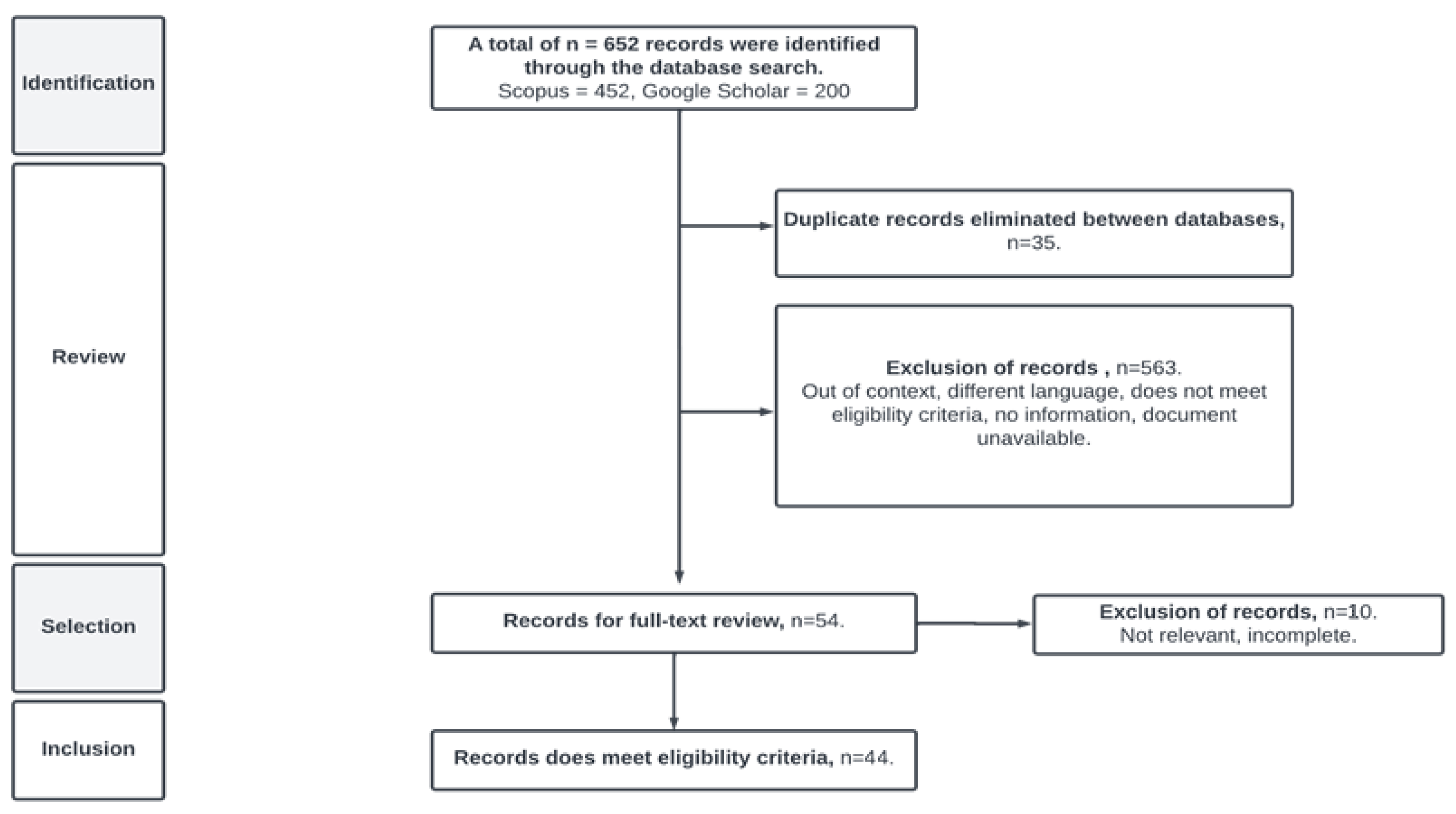
:1. Introduction
2. Literature Review
2.1. Generation of Polluting Emissions
- Hydrocarbons (HC) are a product of the incomplete combustion of fossil fuels, which are made up of hydrogen and carbon atoms, in various combinations. Available in natural liquid (petroleum), condensation liquid, gaseous, and solid form, they are the simplest organic compounds and can be considered the main substances from which all other organic compounds are derived: non-methane hydrocarbons (HCNMs), CO, NOx, non-methane hydrocarbons plus nitrogen oxides (HCNM + NOx), PM. HC reacts with nitrogen oxides and sunlight to form ozone, one of the main components of smog. Ozone irritates the eyes, damages the lungs, aggravates respiratory problems, and can cause cancer [1].
- Lead (PB) emissions by this compound to the atmosphere can occur in gas form from the combustion of alkylated PB additives and in particulate form from various emission sources [36], including batteries. When PB is inhaled as fine particles and deposits in the lungs and subsequently enters the blood, this compound produces bioaccumulation, causing severe damage to the health of living beings and ecosystems.
- Carbon monoxide (CO) is generated from the incomplete combustion of organic matter, with one of the significant emission sources being transportation and the combustion of related fossil hydrocarbons. Even in small concentrations, it is toxic to humans. It serves as a precursor to carbon dioxide and ozone [37]. The effects of breathing in CO have been extensively studied in recent decades, particularly in Latin American countries where air quality and pollution are focal points that affect human health [38,39,40]. In some cases, cardiovascular and neuropsychological problems associated with low levels of this gas have been reported [39,40]. The emission of CO, which occurs between the earth’s surface and the stratosphere, results from the incomplete combustion of carbon, usually caused by vehicular transportation or mobile sources [41,42], and it is both colorless and odorless [39,43]. When this pollutant gas combines with the hemoglobin in the blood, it reduces the flow of necessary oxygen to the human body [44].
- Carbon dioxide (CO2) is a gas formed from the oxidation of carbon atoms during the combustion of all fuels. Emissions from anthropogenic sources are primarily attributed to energy production, vehicles, waste treatment plants, etc. [45]. When studying several types of gases, it is noteworthy that carbon dioxide is the primary one emitted into the atmosphere [18].
- Sulfur oxides (SOxs) are colorless gases that originate from the combustion of any substance containing sulfur. We encounter them artificially through the combustion of fossil fuels [46]. On the other hand, SO2 is produced when burning coal and petroleum-derived fuels, which is why we find them in vehicles and automobiles. It is also a cause of acid rain.
- The primary anthropogenic source of nitrogen dioxide (NO2) is from the use of fossil fuels [46]. This is one of the main contributors to smog, and when it converts to nitric acid, it can lead to acid rain [45]. On the other hand, the most common natural sources are wildfires, grassland fires, and volcanic activity.
- Particulate matter (PM), also known as suspended particles, consists of solid fragments or droplets with various chemical compositions. PM10 refers to particles with a diameter smaller than 10 μm, and PM2.5 represents particles with a diameter smaller than 2.5 μm [45]. Among them, particles are generated from tire wear due to pavement friction, as well as dust particles [47].
2.2. Effect of Emissions on the Environment and Health
2.3. The Importance of Environmental Monitoring on Roads
3. Materials and Methods
- HDM-4 is a model developed for road management that allows for calculations of the amount of pollutant emissions in the form of chemical substances [73].
- COPERT 3 version 2.1 is software used to calculate road transport emissions. This program classifies vehicles into categories and subcategories, according to the type of fuel, vehicle weight, size, engine technology, etc. [74].
- MOBILE 6.0 calculates emission factors for specific vehicle types; the estimation of emission factors depends on conditions, such as the ambient temperature, travel speed, operating modes, fuel volatility, and proportion of distances traveled by each vehicle type [75].
- CALINE 4 is a dispersion model for measuring air quality [76].
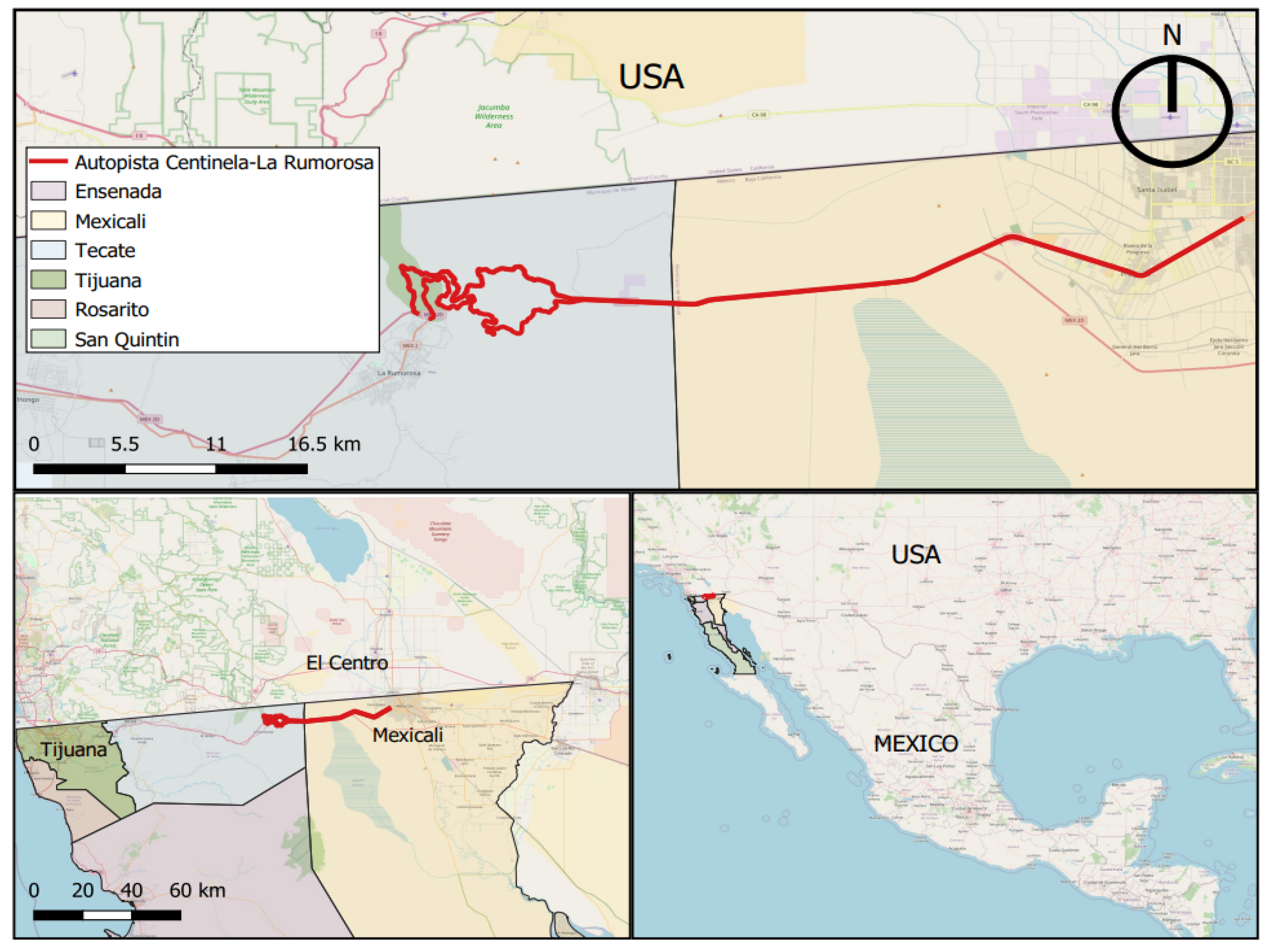
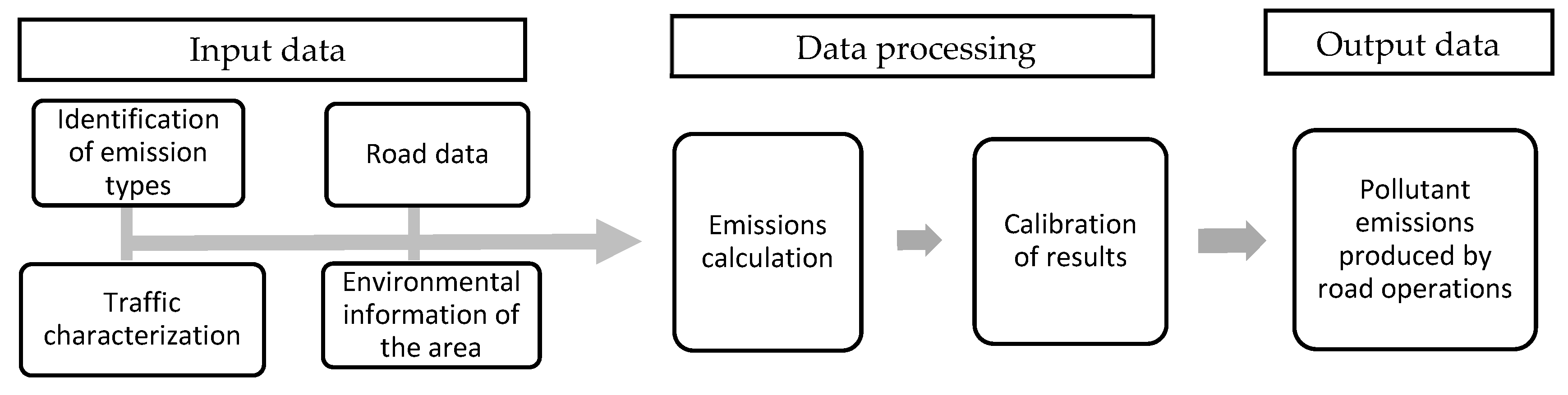
3.1. Input Data
- Identification of emission types.
- Traffic volume on the road section, refers to the annual traffic volume in each flow period, i.e., vehicles per year.
- Vehicle speeds, operational speed of vehicles when traveling on the road.
- Fuel consumption, pertaining to the instantaneous fuel consumption of each vehicle type, in each traffic intensity period.
- Vehicle lifespan and model parameters.
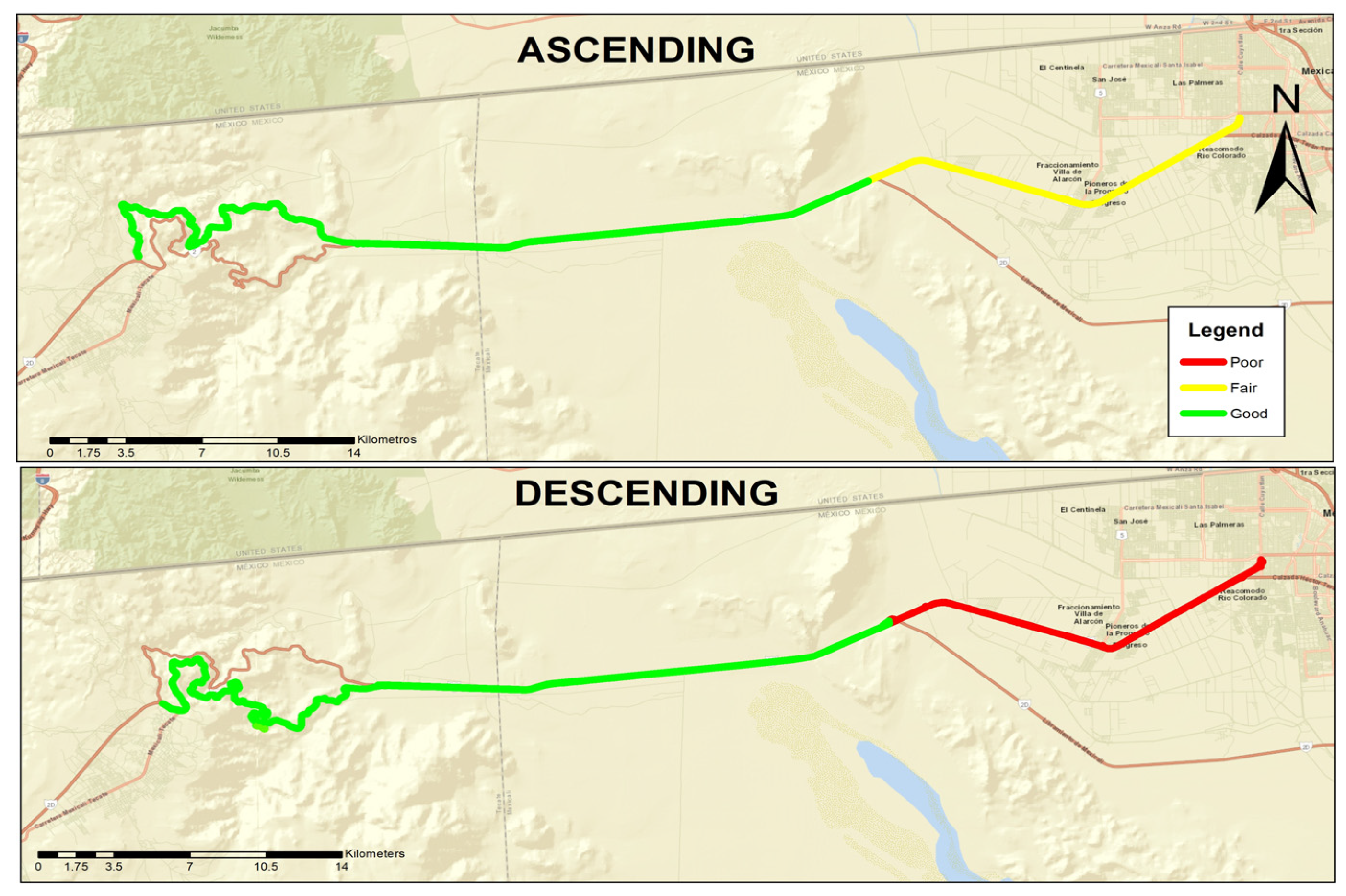
- Characteristics of the road section, such as section length, slopes, and road surface.
- Maximum and minimum temperatures of the study area.
3.2. Data Processing
4. Results and Discussions
5. Concluding Remarks
Author Contributions
Funding
Institutional Review Board Statement
Informed Consent Statement
Data Availability Statement
Conflicts of Interest
References
- Torras, S.; Téllez, R.; Mendoza, J. Análisis Paramétrico del Submodelo Efectos Ambientales del HDM-4. Secretaría de Comunicaciones y Transportes (SCT) e Instituto Mexicano del Transporte (IMT). 2005. Available online: https://www.imt.mx/archivos/Publicaciones/PublicacionTecnica/pt266.pdf (accessed on 15 May 2023).
- Román-Hilario, N. Emisiones Contaminantes de Vehículos del Distrito de Huancayo. Doctoral Tesis, Universidad Nacional Del Centro Del Perú, Huancayo, Peru, 2017. Available online: https://repositorio.uncp.edu.pe/bitstream/handle/20.500.12894/4137/Hilario%20Roman.pdf?sequence=1&isAllowed=y (accessed on 5 March 2023).
- EEA. European Environment Agency. 2005. Available online: https://www.eea.europa.eu (accessed on 15 May 2023).
- Kean, W.; Sotos, M.; Doust, M.; Schultz, S.; Marques, A.; Deng-Beck, C. Protocolo Global para Inventarios de Emisión de Gases de Efecto Invernadero a Escala Comunitaria. Estándar de Contabilidad y de Reporte Para las Ciudades. World Resources Institute, ICLEI y C40. USA. 2014. Available online: https://ghgprotocol.org/sites/default/files/2022-12/GHGP_GPC%20%28Spanish%29.pdf (accessed on 10 March 2023).
- Guerra, J.; Estrategia Nacional de Cambio Climático. Comisión Intersecretarial de Cambio Climático. 2013. Available online: https://www.dof.gob.mx/nota_detalle.php?codigo=5301093&fecha=03/06/2013#gsc.tab=0 (accessed on 10 March 2023).
- Mendoza-Sánchez, J.F.; López-Domínguez, M.G.; González-Moreno, J.O.; Téllez-Gutiérrez, R.; Inventario de Emisiones en Carreteras Federales del Estado de Querétaro. Instituto Mexicano del Transporte. 2011. Issue 339, Volume 1. Available online: https://www.imt.mx/archivos/publicaciones/publicaciontecnica/pt339.pdf (accessed on 1 June 2023).
- Respira México. Retrieved. 2023. Available online: http://respiramexico.org.mx/por-que-respira-mexico/ (accessed on 9 March 2023).
- OMS. Organización Mundial de la Salud. 2023. Available online: https://www.who.int/es/data (accessed on 5 May 2023).
- Dick, H.; Gasca, J.; González, U.; Guzmán, F. Opciones Para Mitigar las Emisiones de Gases Efecto Invernadero del Sector Transportes; Compendio Cambio Climático, Una visión desde México, Instituto Nacional de Ecología: México, México, 2004. [Google Scholar]
- Herrera-Murillo, J.; Rodríguez-Román, S.; Rojas-Marín, J.F. Determinación de las emisiones de contaminantes del aire generadas por fuentes móviles en carreteras de Costa Rica. Rev. Tecnol. Marcha 2012, 25, 54. [Google Scholar] [CrossRef]
- Wichmann, E.; Peters, A. Epidemiological evidence on the effects of ultrafine particle exposure. Philos. Trans. R. Soc. Lond. Ser. A 2000, 358, 2751–2769. [Google Scholar] [CrossRef]
- World Health Organization; Regional Office for Europe. Health Aspects of Air Pollution with Particulate Matter, Ozone and Nitrogen Dioxide: Report on a WHO Working Group, Bonn, Germany, 13–15 January 2003; WHO Regional Office for Europe: Copenhagen, Denmark, 2003. Available online: https://apps.who.int/iris/handle/10665/107478 (accessed on 2 June 2023).
- Lara, C.; Mendoza, J.; López, M.; Téllez, R.; Martínez, W.; Alonso, E. Propuesta Metodológica para la Estimación de Emisiones Vehiculares en Ciudades de la República Mexicana. Secretaría de Comunicaciones y Transporte (SCT)—Instituto Mexicano del Transporte (IMT). 2009. Available online: https://imt.mx/archivos/Publicaciones/PublicacionTecnica/pt322.pdf (accessed on 20 May 2023).
- INECC. Estudio de Emisiones y Actividad Vehicular en Baja California; Instituto Nacional de Ecología y Cambio Climático y Secretaría de Medio Ambiente y Recursos Naturales: México, Mexico, 2011. Available online: https://www.gob.mx/inecc/documentos/2011_cgcsa_rsd_baja-california (accessed on 5 March 2023).
- Calderón-Ramírez, J.; Lomelí-Banda, M.; Mungaray-Moctezuma, A.; Hallack-Alegría, M.; García-Gómez, L. Efectos de CO en la población de las inmediaciones de los cruces fronterizos de México y Estados Unidos. Caso de estudio: Baja California-California. ACE Arquit. Ciudad Y Entorno 2017, 12, 29–44. [Google Scholar] [CrossRef]
- Liu, N.; Wang, Y.; Bai, Q.; Liu, Y.; Wang, P.; Xue, S.; Yu, Q.; Li, Q. Road life-cycle carbon dioxide emissions and emisión reduction technologies: A review. J. Traffic Transp. Eng. 2022, 9, 532–555. [Google Scholar] [CrossRef]
- Montoya-Alcaraz, M.; Mungaray-Moctezuma, A.; Calderón-Ramírez, J.; García, L.; Martínez-Lazcano, C. Road safety analysis of high-risk roads: Case study in Baja California, México. Safety 2020, 6, 45. [Google Scholar] [CrossRef]
- Navalpotro, J.A.S.; Pérez, M.S.; Becerra, A.T. Las emisiones de gases de efecto invernadero en el sector transporte por carretera. Investig. Geográficas 2011, 54, 133–169. [Google Scholar] [CrossRef]
- De Buen, O. Importancia de la Conservación de Carreteras. Asociación Mundial de la Carretera. 2014. Available online: https://www.piarc.org/es/pedido-de-publicacion/22252-es-Importancia%20de%20la%20conservaci%C3%B3n%20de%20carreteras (accessed on 2 June 2023).
- Lizárraga, C. Movilidad urbana sostenible: Un reto para las ciudades del siglo XXI. Econ. Soc. Y Territ. 2006, 22, 283–321. [Google Scholar] [CrossRef]
- Tricco, A.C.; Lillie, E.; Zarin, W.; O’Brien, K.K.; Colquhoun, H.; Levac, D.; Straus, S.E. PRISMA extension for scoping reviews (PRISMA-ScR): Checklist and explanation. Ann. Intern. Med. 2018, 169, 467–473. [Google Scholar] [CrossRef] [PubMed]
- Ouzzani, M.; Hammady, H.; Fedorowicz, Z.; Elmagarmid, A. Rayyan—A web and mobile app for systematic reviews. Syst. Rev. 2016, 5, 210. [Google Scholar] [CrossRef]
- Aromataris, E.; Fernández, R.; Godofredo, C.M.; Acebo, C.; Jalil, H.; Tungpunkom, P. Resumen de las revisiones sistemáticas: Desarrollo metodológico, realización y presentación de informes de un enfoque de revisión general. Evid. JBI Implement. 2015, 13, 132–140. [Google Scholar]
- Singh, S.; Kulshrestha, M.J.; Rani, N.; Kumar, K.; Sharma, C.; Aswal, D.K. An Overview of Vehicular Emission Standards. MAPAN-J. Metrol. Soc. India 2023, 38, 241–263. [Google Scholar] [CrossRef]
- Smit, R.; Ntziachristos, L.; Boulter, P. Validation of road vehicle and traffic emission models e A review and meta-analysis. Atmos. Environ. 2010, 44, 2943–2953. [Google Scholar] [CrossRef]
- Franco, V.; Kousoulidou, M.; Muntean, M.; Ntziachristos, L.; Hausberger, S.; Dilara, P. Road vehicle emission factors development: A review. Atmos. Environ. 2013, 70, 84–97. [Google Scholar] [CrossRef]
- Zhang, L.; Long, R.; Chen, H.; Geng, J. A review of China’s road traffic carbon emissions. J. Clean. Prod. 2019, 207, 569–581. [Google Scholar] [CrossRef]
- Baškovic, K.; Knez, M. A review of vehicular emission models. In Proceedings of the 10th International Conference on Logistics & Sustainable Transport, Celje, Slovenia, 13–15 June 2013. [Google Scholar]
- Onga, H.; Mahliaa, T.; Masjuki, H. A review on emissions and mitigation strategies for road transport in Malaysi. Renew. Sustain. Energy Rev. 2011, 15, 3516–3522. [Google Scholar] [CrossRef]
- McKinnon, A.; Piecyk, M. Measurement of CO2 emissions from road freight transport: A review of UK experience. Energy Policy 2009, 37, 3733–3742. [Google Scholar] [CrossRef]
- Alkafoury, A.; Bady, M.; Hafez, M.; Negm, A. Emissions Modeling for Road Transportation in Urban Areas: State-of-Art Review. In Proceeding of the 23rd International Conference on―Environmental Protection is a Must, Alexandria, Egypt, 11–13 May 2013. [Google Scholar]
- Zacharof, N.; Fontaras, G.; Ciuffo, B.; Tansini, A. An estimation of heavy-duty vehicle fleet CO2 emissions based on sampled data. Transp. Res. Part D 2021, 94, 102784. [Google Scholar] [CrossRef]
- Llopis, D.; Camacho, F.; Garcia, A. Analysis of the influence of geometric design consistency on vehicle CO2 emissions. Transp. Res. Part D 2019, 69, 40–50. [Google Scholar] [CrossRef]
- Suarez, J.; Makridis, M.; Anesiadou, A.; Komnos, D.; Ciuffo, B.; Fontaras, G. Benchmarking the driver acceleration impact on vehicle energy. Transp. Res. Part D 2022, 107, 103282. [Google Scholar] [CrossRef] [PubMed]
- Albores, M.; Regan, M.; Guilbeault, S.; Emisiones de Contaminantes. Comisión Para la Cooperación Ambiental. 2020. Available online: https://www.cec.org/sites/default/napp/es/pollutant-emissions.php (accessed on 23 April 2023).
- SEMARNAT. Guía Metodológica Para la Estimación de Emisiones Vehicular en Ciudades Mexicanas; Secretaria de Medio Ambiente y Recursos Naturales: México, Mexico, 2009.
- Hernández, J.; Madrigal, D.; Morales, C. Comportamiento del monóxido de carbono y el clima en la ciudad de Toluca, de 1995 a 2001. En Cienc. Ergo Sum Cienc. De La Tierra Y De La Atmósfera 2005, 11, 263–274. [Google Scholar]
- ENVIRA. Contaminantes Primarios y Secundarios: Estos Son Los Más Peligrosos. 2022. Available online: https://enviraiot.es/contaminantes-primarios-y-secundarios-mas-peligrosos/ (accessed on 12 March 2023).
- Téllez, J.; Ii, A.; Fajardo, A. Contaminación por monóxido de carbono: Un problema de salud ambiental. Rev. Salud Pública 2006, 8, 108–117. [Google Scholar] [CrossRef]
- Rojas, M.; Dueñas, A.; Sidorovas, L. Evaluación de la exposición al monóxido de carbono en vendedores de quioscos. Valencia, Venezuela. Rev. Panam. Salud Pública/Pan Am. J. Public Health 2001, 9, 240–244. [Google Scholar] [CrossRef]
- Logan, J.; Prather, M.; Wofsy, S.; Mcelroy, B. Tropospheric Chemistry: A Global Perspective. J. Geophys. Res. Ocean. 1981, 86, 7210–7254. [Google Scholar] [CrossRef]
- Peñaloza, N. Distribución Espacial y Temporal del Inventario de Emisiones Provenientes de las Fuentes Móviles y Fijas dela Ciudad de Bogotá D.C. Tesis de Maestría, Universidad Nacional de Colombia, Bogotá, Colombia, 2010. [Google Scholar]
- CORPAIRE. Corporación Para el Mejoramiento del Aire de Quito; Índice Quiteño de Calidad del Aire: Quito, Ecuador, 2004. [Google Scholar]
- INECC. Instituto Nacional de Ecología y Cambio Climático. Guía Metodológica para la Estimación de Emisiones Vehiculares en Ciudades Mexicanas; INECC: México, Mexico, 2007; 23p.
- Gómez, H.; Cuadra, M.; Alvarado, L. Instrumentos Básicos Para la Fiscalización Ambiental. Organismo de Evaluación y Fiscalización Ambiental OEFA. 2015. Available online: https://www.oefa.gob.pe/?wpfb_dl=13978.8 (accessed on 9 February 2023).
- Vidal, M.; Castro, J.; Morales, D. Informe Nacional de la Calidad del Aire 2013–2014; Ministerio del Ambiente MINAM: Lima, Perú, 2014. Available online: https://www.minam.gob.pe/wp-content/uploads/2016/07/Informe-Nacional-de-Calidad-del-Aire-2013-2014.pdf (accessed on 2 March 2023).
- Julia, C.; Fussell, J.; Franklin, M.; Green, D.; Gustafsson, M.; Harrison, R.; Hicks, W.; Kelly, F.; Kishta, F.; Miller, M.; et al. A Review of Road Traffic-Derived Non-Exhaust Particles: Emissions, Physicochemical Characteristics, Health Risks, and Mitigation Measures. Environ. Sci. Technol. 2022, 56, 6813–6835. [Google Scholar] [CrossRef]
- Fernández, A.; Emisiones Del Sector Transporte. Iniciativa Climática De México, ICM. 2021, p. 9. Available online: https://www.iniciativaclimatica.org/wp-content/uploads/2021/10/COP26-T9_Transporte_final.pdf (accessed on 19 February 2023).
- Encinas-Malagón, M.D. Medio Ambiente y Contaminación. Principios Básicos. 2011. ISBN 978-84-615-1145-7. Universidad del país Vasco, España. Available online: https://addi.ehu.es/handle/10810/16784 (accessed on 15 May 2023).
- Ministerio del Ambiente. Efectos de la Contaminación del Aire. Bicentenario Perú. 2021. Available online: https://infoaireperu.minam.gob.pe/efectos-de-la-contaminacion-del-aire/ (accessed on 6 January 2023).
- Centro Panamericano de Ingeniería Sanitaria y Ciencias del Ambiente (CEPIS) y Organización Mundial de la Salud (OMS). Curso de Orientación Para el Control de la Contaminación del Aire; Manual de Auto Instrucción: Lima, Perú, 1999.
- Londoño-Echeverri, C.A. Estimación de la emisión de gases de efecto invernadero en el municipio de Montería. Rev. Ing. Univ. Medellín 2006, 5, 85–96. [Google Scholar]
- Mukherjee, A.; McCarthy, M.; Huang, S.; Landsberg, K.; Eisinger, D. Influence of roadway emissions on near-road PM2.5: Monitoring data analysis and implications. Transp. Res. Part D 2020, 86, 102442. [Google Scholar] [CrossRef]
- Amirjamshidi, G.; Mostafa, T.; Misra, A.; Roorda, M. Integrated model for microsimulating vehicle emissions, pollutant dispersion and population exposure. Transp. Res. Part D 2013, 18, 16–24. [Google Scholar] [CrossRef]
- Mishra, R.K.; Shukla, A.; Parida, M.; Pandey, G. Urban roadside monitoring and prediction of CO, NO2 and SO2 dispersion from on-road vehicles in megacity Delhi. Transp. Res. Part D 2016, 46, 157–165. [Google Scholar] [CrossRef]
- Slezakova, K.; Castro, D.; Delerue-Matos, C.; Alvim-Ferraz, M.C.; Morais, S.; Pereira, M.C. Air pollution fromtraffic emissions in Oporto, Portugal: Health and environmental implications. Microchem. J. 2011, 99, 51–59. [Google Scholar] [CrossRef]
- Fernández-Cadete, A.; Írsula-Marén, K.; Santana-Romero, J. Behavior of Air Pollution in Industries and Its Impact on Human Health; Santiago: Santiago de Compostela, Spain, 2020; p. 152. ISSN 2227-6513. [Google Scholar]
- López, E.M.; Quiroz, C.M.; Cardozo, F.D.; Espinosa, A.M. Contaminación Atmosférica; Facultad Nacional de Salud Pública-Universidad de Antioquia: Medellín, Colombia, 2007. [Google Scholar]
- Palacios, E.E.; Espinoza, M.C. Contaminación del Aire Exterior Cuenca—Ecuador 2009–2013, Posibles Efectos en la Salud; Revista de la Facultad de Ciencias Médicas Universidad de Cuenca: Paris, France, 2014; p. 8. [Google Scholar]
- Adame, A. Contaminación Ambiental y Calentamiento Global; Ed. Trillas: México, Mexico, 2010; ISBN 978-607-17-0339-2. [Google Scholar]
- Bukola, O. Vehicle Emissions and their effects on the natural environment, a review. J. Ghana Inst. Eng. 2006, 4, 35–41. [Google Scholar]
- Xu, M.; Weng, Z.; Xie, Y.; Chen, B. Environment and health co-benefits of vehicle emission control policy in Hubei, China. Transp. Res. Part D 2023, 120, 103773. [Google Scholar] [CrossRef]
- Davoudi, M.; Barjasteh-Askari, F.; Amini, H.; Lester, D.; Mahvi, A.H.; Ghavami, V. Association of suicide with short-term exposure to air pollution at different lag times: A systematic review and meta-analysis. Sci. Total Environ. 2021, 771, 144882. [Google Scholar] [CrossRef]
- Urbano, P.M.; Gutiérrez, J.I.S.; Ríos, A.Y.H. Modelos de transporte por carretera y emisiones de carbono aplicables en las ciudades y su entorno. Cuadernos de Trabajo de Estudios Regionales en Economía, Población y Desarrollo 2019, 9, 3–45. [Google Scholar]
- Martínez, A.; Hernández, S. Catálogo de Impactos Ambientales Generados por las Carreteras y sus Medidas de Mitigación; Publicación Técnica; Instituto Mexicano del Transporte: México, México, 1999. [Google Scholar]
- Cohen, A.J.; Brauer, M.; Burnett, R.; Anderson, H.R.; Frostad, J.; Estep, K.; Balakrishnan, K.; Brunekreef, B.; Morawska, L.; Iii, C.A.P.; et al. Estimates and 25-year trends of the global burden of disease attributable to ambient air pollution: An analysis of data from the Global Burden of Diseases Study 2015. Lancet 2015, 389, 1907–1918. [Google Scholar] [CrossRef] [PubMed]
- Dünnebeil, F.; Knörr, W.; Heidt, C.; Heuer, C.; Lambrecht, U. Balancing Transport Greenhouse Gas Emissions in Cities—A Review of Practices in Germany; Transport Demand Management in Beijing, Final Report, October; Deutsche Gesellschaft für Internationale Zusammenarbeit (GIZ) GmbH and the Beijing Transportation Research Center (BTRC): Beijing, China, 2017; pp. 3–11. [Google Scholar]
- Mendoza, J.F.; López, M.G.; Téllez, R. Monitoreo Ambiental en Carreteras. 2010. Available online: https://www.researchgate.net/publication/344891909_MONITOREO_AMBIENTAL_EN_CARRETERAS (accessed on 13 June 2023).
- Odoki, J.B.; Kerali, H.G. HDM-4: Highway Development and Management. Volume Four: Analytical Framework and Model Descriptions; Asociación Mundial de Carreteras (PIARC): París, France, 2000. [Google Scholar]
- Prasad, C.; Swamy, A.K.; Tiwari, G. Calibration of HDM-4 Emission Models for Indian Conditions. Procedia—Soc. Behav. Sci. 2013, 104, 274–281. [Google Scholar] [CrossRef]
- Shrivastava, R.; Saxena, N.; Gautam, G. Air pollution due to road transportation in India: A review on assessment and reduction strategies. J. Environ. Res. Dev. 2013, 8, 69. [Google Scholar]
- Winkler, S.; Anderson, J.; Garza, L.; Ruona, W.; Vogt, R.; Wallington, T. Vehicle criteria pollutant (PM, NOx, CO, HCs) emissions: How low should we go? Clim. Atmos. Sci. 2018, 1, 26. [Google Scholar] [CrossRef]
- Torras Ortiz, S.; Friedrich, R. A modelling approach for estimating background pollutant concentrations in urban areas. Atmos. Pollut. Res. 2013, 4, 147–156. [Google Scholar] [CrossRef]
- Ntziachristos, L.; Samaras, Z. COPERT III Computer programme to calculate emissions from road transport. Delivery of Road Transport Emission data for EU 15 country. Eur. Environ. Agency 2000, 49, 86. [Google Scholar]
- Jaramillo, M.; Núñez, M.E.; Ocampo, W. Inventario de emisiones de contaminantes atmosféricos convencionales en la zona de Cali-Yumbo. Rev. Fac. De Ing. Univ. De Antioq. 2004, 31, 38–48. [Google Scholar]
- González, D.; Cogliati, M. Study of vehicle emissions between Neuquén and Centenario, Argentina. Atmosfera 2016, 29, 267–277. [Google Scholar] [CrossRef]
- SICT. Datos viales Estado de México 2018. Secretaria de Comunicaciones y Transporte. 2018. Available online: https://www.sct.gob.mx/carreteras/direccion-general-de-serviciostecnicos/datos-viales/2018/ (accessed on 10 March 2023).
- FIARUM. Fideicomiso Público de Administración de Fondos e Inversión del Tramo Carretero Centinela-La Rumorosa, México. 2018. Available online: https://www.bajacalifornia.gob.mx/fiarum/ (accessed on 10 March 2023).
- Comisión Nacional del Agua CONAGUA. Información de Estadística Climatológica. 2023. Available online: https://smn.conagua.gob.mx/es/climatologia/informacion-climatologica/informacion-estadistica-climatologica (accessed on 15 March 2023).
- Odoki, J.B.; Henry, G.R.; Kerali. HDM-4: Highway Development and Management. Volume Four: Analytical Framework and Model Descriptions; Asociación Mundial de Carreteras (PIARC): París, France, 2000. [Google Scholar]
- SICT, Norma Oficial Mexicana NOM-012-SCT-2-2017; Sobre el Peso y Dimensiones Máximas Con Los que Pueden Circular Los Vehículos de Autotransporte Que Transitan en las Vías Generales de Comunicación de Jurisdicción Federal. Norma Oficial Mexicana México, Diario Oficial de la Federación México, Distrito Federal: Ciudad de México, México, 2017.
- Zhang, M. Effects of road maintenance on vehicle emissions evaluating by the model of highway development and management. In Proceedings of the 4th International Conference on Sustainable Energy and Environmental Engineering, Shenzhen, China, 30–31 December 2016. [Google Scholar]
- Nyaga, E.W. Aerosol Remote Sensing and Modelling: Estimation of Vehicular Emission Impact on Air Pollution in Nairobi, Kenya. Doctoral Dissertation, University of Nairobi, Nairobi, Kenya, 2021. [Google Scholar]
- Bennett, C.R.; Greenwood, I.D. Modeling Road User and Environmental Effects in HDM-4, Version 3.0; International Study of Highway Development and Management Tools (ISOHDM); World Road Association (PIARC): Paris, France, 2003; Volume 7. [Google Scholar]
- Arroyo, J.; Torres, G.; González, J.; Hernández, S. Costos de Operación Base de Los Vehículos Representativos del Transporte Interurbano 2018. Instituto Mexicano del Transporte y Secretaria de Comunicaciones y Transportes. Publicación Técnica. 2018. Available online: https://imt.mx/archivos/Publicaciones/PublicacionTecnica/pt526.pdf (accessed on 13 April 2023).
- Cal, R.; Cárdenas, J. Ingeniería de Tránsito: Fundamentos y Aplicaciones; Alpha Editorial: Bogota, Colombia, 2018. [Google Scholar]
- Secretaria de Comunicaciones y Transportes. Velocidades de Punto, Adendum al Libro Datos Viales. 2020. Available online: https://www.sct.gob.mx/fileadmin/DireccionesGrales/DGST/Velocidades_de_punto/Vel-DV2020.pdf (accessed on 2 March 2023).
- Instituto Nacional de Estadística y Geografía. Geografía y Medio Ambiente. 2023. Available online: https://www.inegi.org.mx/temas/climatologia/ (accessed on 29 February 2024).
- The World Air Quality Project. Air Quality Historical Data Platform. 2023. Available online: https://aqicn.org/data-platform/register/ (accessed on 29 March 2023).
- SINAICA. Sistema Nacional de Información de la Calidad del Aire. 2023. Available online: https://sinaica.inecc.gob.mx/ (accessed on 15 November 2023).
- Hammerstrom, U. Proposal for a Vehicle Exhaust Model in HDM-4, ISOHDM Supplementary Technical Relationships Study, Draft Report; Administradora Sueca de Caminos: Borlange Sweden, 1995. [Google Scholar]
- NOM-020-SSA1-2014. Norma Oficial Mexicana “Valor Límite Permisible Para la Concentración de Ozono (O3) en el Aire Ambiente y Criterios Para su Evaluación”. Available online: http://diariooficial.gob.mx/nota_detalle.php?codigo=5356801&fecha=19/08/2014#gsc.tab=0 (accessed on 15 November 2023).
- NOM-022-SSA1-2019. Norma Oficial Mexicana “Criterio Para Evaluar la Calidad del Aire Ambiente, con Respecto al Dióxido de Azufre (SO2). Valores Normados Para la concentración de dióxido de azufre (SO2) en el Aire Ambiente”. Available online: https://www.dof.gob.mx/nota_detalle.php?codigo=5568395&fecha=20/08/2019#gsc.tab=0 (accessed on 15 November 2023).
- NOM-021-SSA1-2021. Norma Oficial Mexicana “Criterio Para Evaluar la Calidad del Aire Ambiente, con Respecto al Monóxido de Carbono (CO). Valores Normados Para la Concentración de Monóxido de Carbono (CO) en el Aire Ambiente”. Available online: https://dof.gob.mx/nota_detalle.php?codigo=5634084&fecha=29/10/2021#gsc.tab=0 (accessed on 15 November 2023).
- NOM-023-SSA1-2021. Norma Oficial Mexicana “Criterio Para Evaluar la Calidad del Aire Ambiente, con Respecto al Dióxido de Nitrógeno (NO2). Valores Normados Para la Concentración de Dióxido de Nitrógeno (NO2) en el Aire Ambiente”. Available online: https://www.dof.gob.mx/nota_detalle.php?codigo=5633854&fecha=27/10/2021#gsc.tab=0 (accessed on 15 November 2023).
- NOM-025-SSA1-2021. Norma Oficial Mexicana “Criterio Para Evaluar la Calidad del Aire Ambiente, con Respecto a las Partículas Suspendidas PM10 y PM2.5. Valores Normados Para la Concentración de Partículas Suspendidas PM10 y PM2.5 en el Aire Ambiente”. Available online: https://www.dof.gob.mx/nota_detalle.php?codigo=5633855&fecha=27/10/2021#gsc.tab=0 (accessed on 15 November 2023).
- NOM-026-SSA1-2021. Norma Oficial Mexicana “Criterio Para Evaluar la Calidad del Aire Ambiente, con Respecto al Plomo (Pb). Valor Normado Para la Concentración de Plomo (Pb) en el Aire Ambiente”. Available online: https://www.dof.gob.mx/nota_detalle.php?codigo=5634085&fecha=29/10/2021#gsc.tab=0 (accessed on 10 June 2023).
- Zhu, S.; Qiao, Y.; Peng, W.; Zhao, Q.; Li, Z.; Liu, X.; Wang, H.; Song, G.; Yu, L.; Shi, L. An Experimental Framework of Particulate Matter Emission Factor Development for Traffic Modeling. Atmosphere 2023, 14, 706. [Google Scholar] [CrossRef]


 | A2 | Light Vehicles |
|---|---|---|
 | A′2 | Pick-Ups |
 | B2 | 2-Axle Buses |
 | B3 | 3-Axle Buses |
 | C2 | 2-Axle Cargo Trucks |
 | C3 | 3-Axle Cargo Trucks |
 | T3-S2 | Articulated Truck |
 | T3-S3 | |
 | T3-S2-R4 |
| Section | km from 0–18 | km from 18–42 | km from 42–64 |
|---|---|---|---|
| Uphill | 6307 | 5513 | 4185 |
| Downhill | 6358 | 5622 | 3775 |
| Uphill | Downhill | ||||
|---|---|---|---|---|---|
| VCL | Quantity | Vehicle Percentage | Vehicle Type | Quantity | Vehicle Percentage |
| A2 | 4730 | 75 | A2 | 4641 | 73 |
| A′2 | 25 | 0.4 | A′2 | 64 | 1 |
| B2 | 63 | 1 | B2 | 64 | 1 |
| B3 | 139 | 2.2 | B3 | 134 | 2.1 |
| C2 | 675 | 10.7 | C2 | 648 | 10.2 |
| C3 | 151 | 2.4 | C3 | 203 | 3.2 |
| T3-S2 | 372 | 5.9 | T3-S2 | 439 | 6.9 |
| T3-S3 | 76 | 1.2 | T3-S3 | 76 | 1.2 |
| T3-S2-R4 | 76 | 1.2 | T3-S2-R4 | 89 | 1.4 |
| Total | 6307 | 100 | Total | 6358 | 100 |
| Uphill | Downhill | ||||
|---|---|---|---|---|---|
| VCL | Quantity | Vehicle Percentage | Vehicle Type | Quantity | Vehicle Percentage |
| A2 | 3969 | 72 | A2 | 3935 | 70 |
| A′2 | 6 | 0.1 | A′2 | 34 | 0.6 |
| B2 | 55 | 1 | B2 | 56 | 1 |
| B3 | 127 | 2.3 | B3 | 135 | 2.4 |
| C2 | 474 | 8.6 | C2 | 522 | 9.3 |
| C3 | 72 | 1.3 | C3 | 79 | 1.4 |
| T3-S2 | 529 | 9.6 | T3-S2 | 557 | 9.9 |
| T3-S3 | 154 | 2.8 | T3-S3 | 163 | 2.9 |
| T3-S2-R4 | 127 | 2.3 | T3-S2-R4 | 141 | 2.5 |
| Total | 5513 | 100 | Total | 5622 | 100 |
| Uphill | Downhill | ||||
|---|---|---|---|---|---|
| VCL | Quantity | Vehicle Percentage | Vehicle Type | Quantity | Vehicle Percentage |
| A2 | 2720 | 65 | A2 | 2567 | 68 |
| A´2 | 17 | 0.4 | A´2 | 8 | 0.2 |
| B2 | 80 | 1.9 | B2 | 72 | 1.9 |
| B3 | 126 | 3 | B3 | 113 | 3 |
| C2 | 397 | 9.5 | C2 | 339 | 9 |
| C3 | 42 | 1 | C3 | 34 | 0.9 |
| T3-S2 | 556 | 13.3 | T3-S2 | 457 | 12.1 |
| T3-S3 | 80 | 1.9 | T3-S3 | 23 | 0.6 |
| T3-S2-R4 | 167 | 4 | T3-S2-R4 | 162 | 4.3 |
| Total | 4185 | 100 | Total | 3775 | 100 |
| VCL | Legal Speed (km/h) | Median Speed (km/h) | Max Speed (km/h) | ||||||
|---|---|---|---|---|---|---|---|---|---|
| Plain | Uphill | Downhill | Plain | Uphill | Downhill | Plain | Uphill | Downhill | |
| Car | 110 | 80 | 80 | 111 | 79 | 76 | 158 | 118 | 138 |
| Bus | 80 | 60 | 60 | 104 | 66 | 57 | 133 | 88 | 83 |
| Trucks | 80 | 60 | 60 | 90 | 51 | 57 | 133 | 88 | 93 |
| Kilometers/Area | |||||
|---|---|---|---|---|---|
| Compound | Urban Area km 0–18 | Laguna Salada km 18–42 | Mountainous Area km 42–64 | Totals (g) | Total (Ton) |
| HC | 535,569.18 | 620,600.50 | 315,859.84 | 1,472,029.52 | 1.47 |
| CO | 3,901,463.07 | 4,336,926.05 | 1,965,043.53 | 10,203,432.64 | 10.20 |
| NOx | 1,392,773.90 | 1,855,356.39 | 1,243,735.03 | 4,491,865.32 | 4.49 |
| PM | 27,720.09 | 35,998.32 | 32,220.99 | 95,939.40 | 0.10 |
| CO2 | 95,241,818.04 | 124,295,181.33 | 86,868,295.74 | 306,405,295.11 | 306.41 |
| SO2 | 14,018.98 | 19,191.13 | 14,578.02 | 47,788.12 | 0.05 |
| Pb | 18,765,391.86 | 20,958,666.62 | 10,052,981.52 | 49,777,040.00 | 49.78 |
| km from 0–18 | km from 18–42 | km from 42–64 | |
|---|---|---|---|
| CO2 | 95,241,818.04 | 124,295,181.33 | 86,868,295.74 |
| Road km | 36 | 48 | 44 |
| Emissions per km | 2,645,606.06 | 2,589,482.94 | 1,974,279.45 |
| AADT | 12,665 | 11,135 | 7,960 |
| Emissions per vehicle | 208.89 | 232.55 | 248.03 |
Disclaimer/Publisher’s Note: The statements, opinions and data contained in all publications are solely those of the individual author(s) and contributor(s) and not of MDPI and/or the editor(s). MDPI and/or the editor(s) disclaim responsibility for any injury to people or property resulting from any ideas, methods, instructions or products referred to in the content. |
© 2024 by the authors. Licensee MDPI, Basel, Switzerland. This article is an open access article distributed under the terms and conditions of the Creative Commons Attribution (CC BY) license (https://creativecommons.org/licenses/by/4.0/).
Share and Cite
Calderón-Ramírez, J.; Gutiérrez-Moreno, J.M.; Montoya-Alcaraz, M.; Casillas, Á. Measurement of Road Transport Emissions, Case Study: Centinela-La Rumorosa Road, Baja California, México. Appl. Sci. 2024, 14, 2921. https://doi.org/10.3390/app14072921
Calderón-Ramírez J, Gutiérrez-Moreno JM, Montoya-Alcaraz M, Casillas Á. Measurement of Road Transport Emissions, Case Study: Centinela-La Rumorosa Road, Baja California, México. Applied Sciences. 2024; 14(7):2921. https://doi.org/10.3390/app14072921
Chicago/Turabian StyleCalderón-Ramírez, Julio, José Manuel Gutiérrez-Moreno, Marco Montoya-Alcaraz, and Ángel Casillas. 2024. "Measurement of Road Transport Emissions, Case Study: Centinela-La Rumorosa Road, Baja California, México" Applied Sciences 14, no. 7: 2921. https://doi.org/10.3390/app14072921