Analysis of Spatial Variability of Plough Layer Compaction by High-Power and No-Tillage Multifunction Units in Northeast China
Abstract
:1. Introduction
2. Materials and Methods
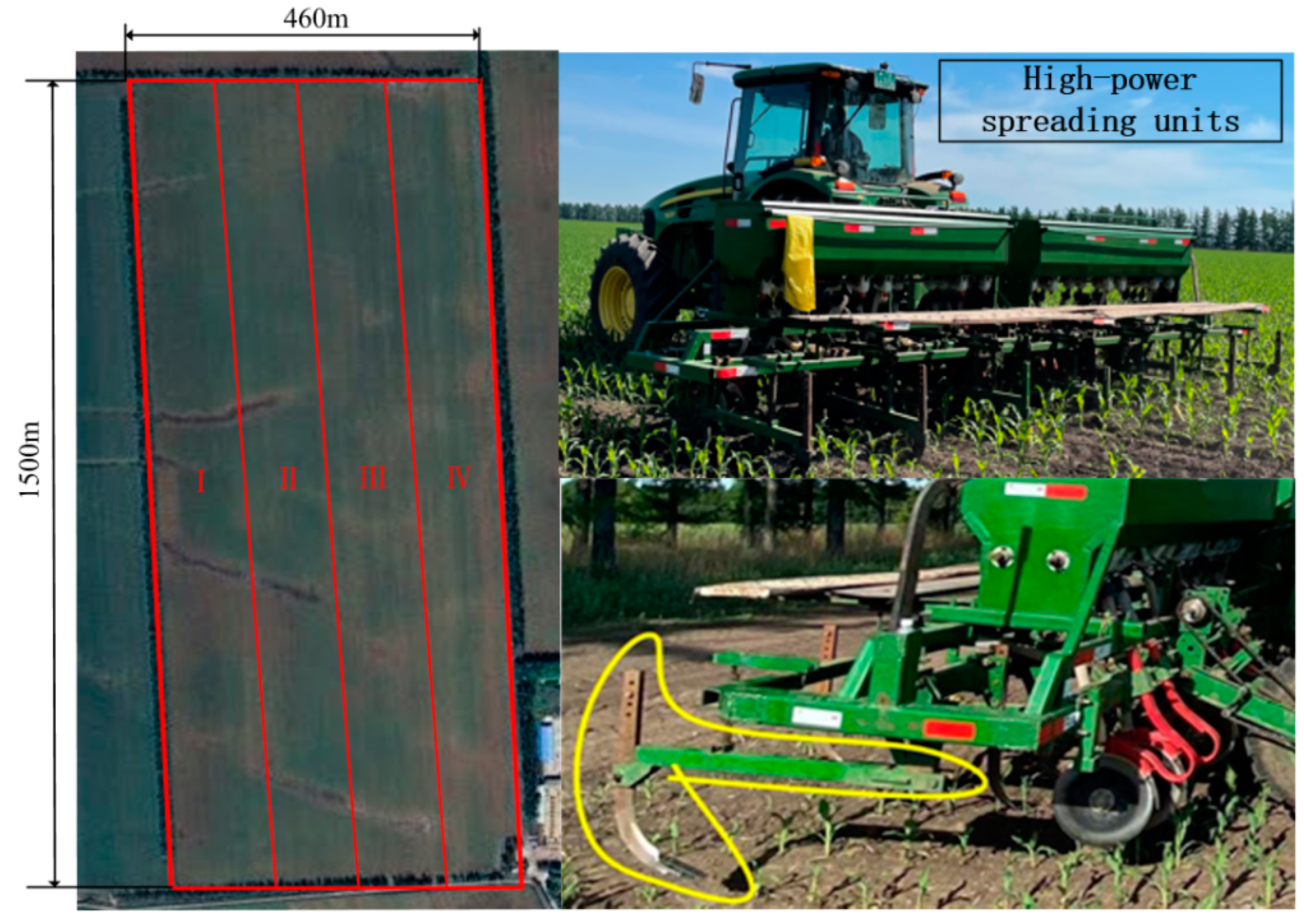
2.1. Overview of the Experimental Area
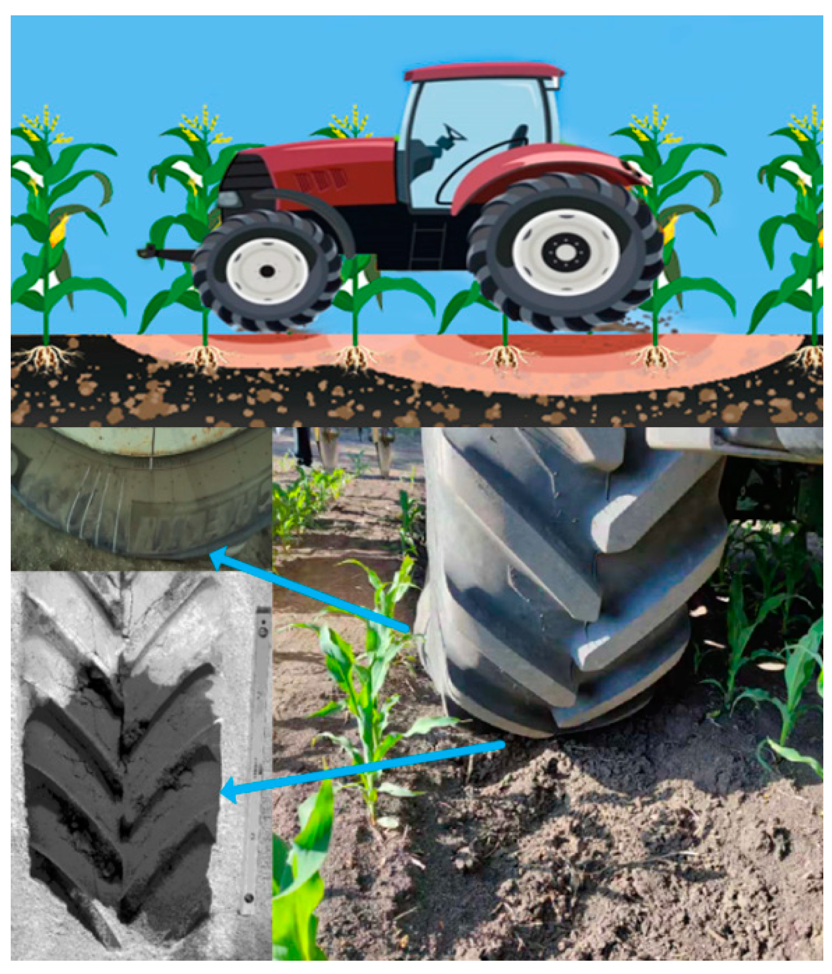
2.2. Experimental Scheme
3. Results
4. Discussion
4.1. Basic Concepts of GIS Systems
4.2. Principle of the Kriging Method
4.2.1. Basic Theory of the Kriging Method
4.2.2. Semi-Variable Function Theoretical Model
4.2.3. Maximum Separation Distance and Grouping Step
5. Discussion
5.1. Analysis of Longitudinal Spatial Variability of Physical Parameters in Cultivated Soils
5.1.1. Analysis of the Longitudinal Spatial Semi-Variance Function and Interpolation Results of Soil Compactness in the Cultivated Layer
5.1.2. Analysis of the Longitudinal Spatial Semi-Variance Function and Interpolation Results of the Water Content of Cultivated Soils
5.1.3. Analysis of the Longitudinal Spatial Semi-Variance Function and Interpolation Results of the Porosity of Cultivated Soils
5.2. Analysis of the Lateral Spatial Variability of Physical Parameters in Cultivated Soils
5.2.1. The Effect of Tillage Compaction on the Spatial Lateral Variability of Soil Compactness in the Cultivated Layer
5.2.2. The Effect of Tillage Compaction on the Spatial Lateral Variability of Soil Water Content in the Tillage Layer
5.2.3. The Effect of Tillage Compaction on the Spatial Lateral Variability of Soil Porosity in the Cultivated Layer
6. Conclusions
- (1)
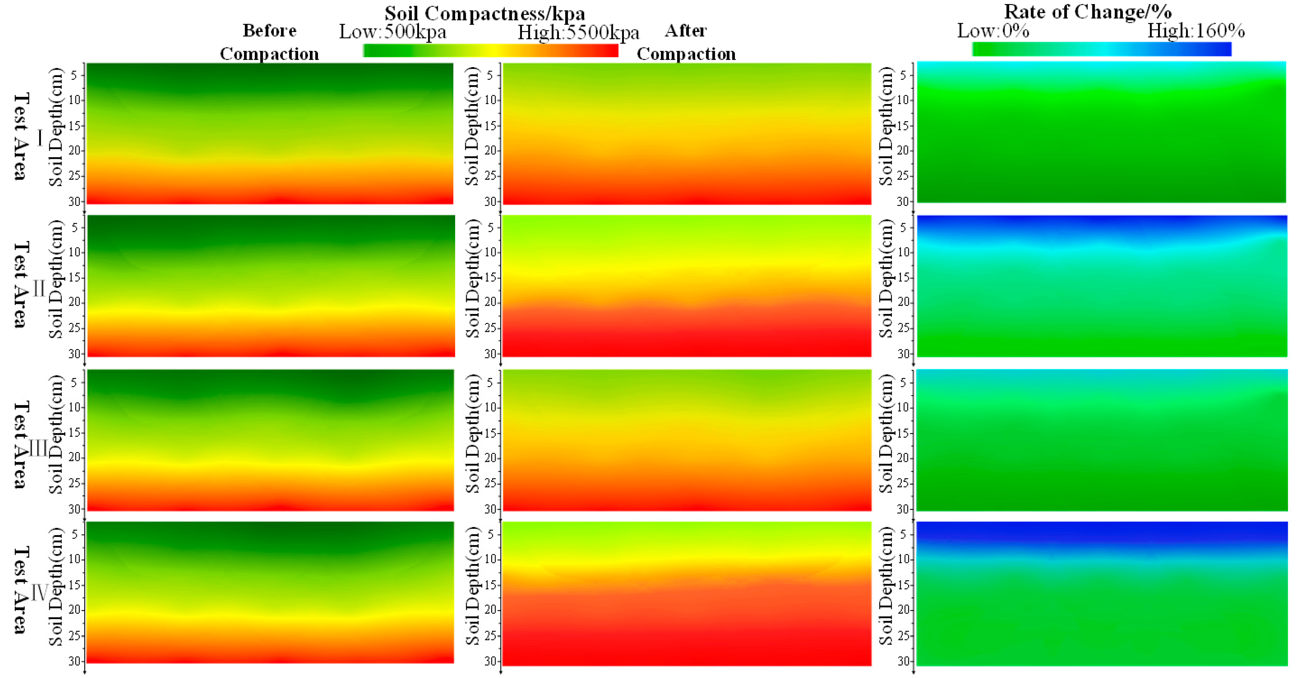
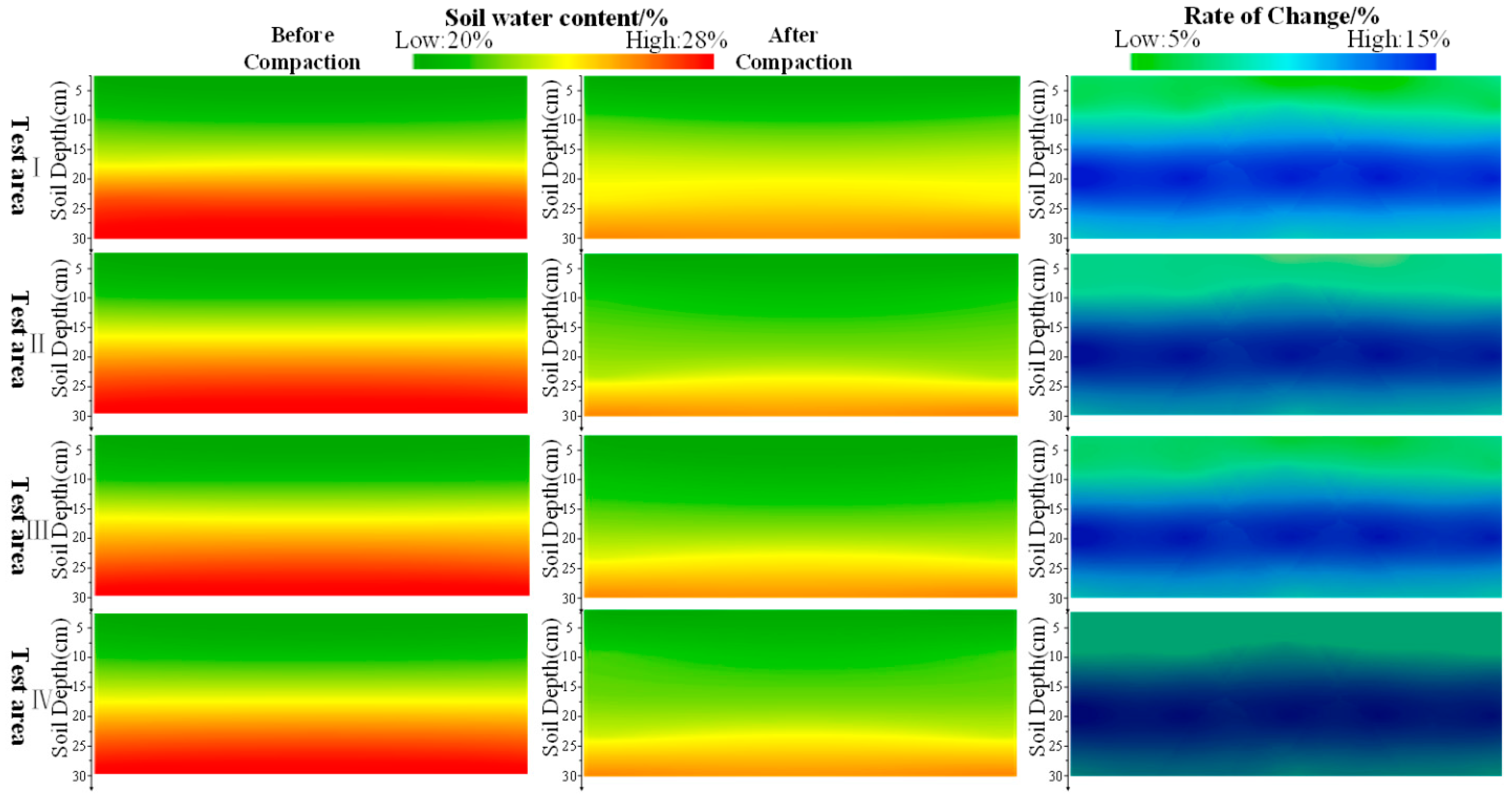
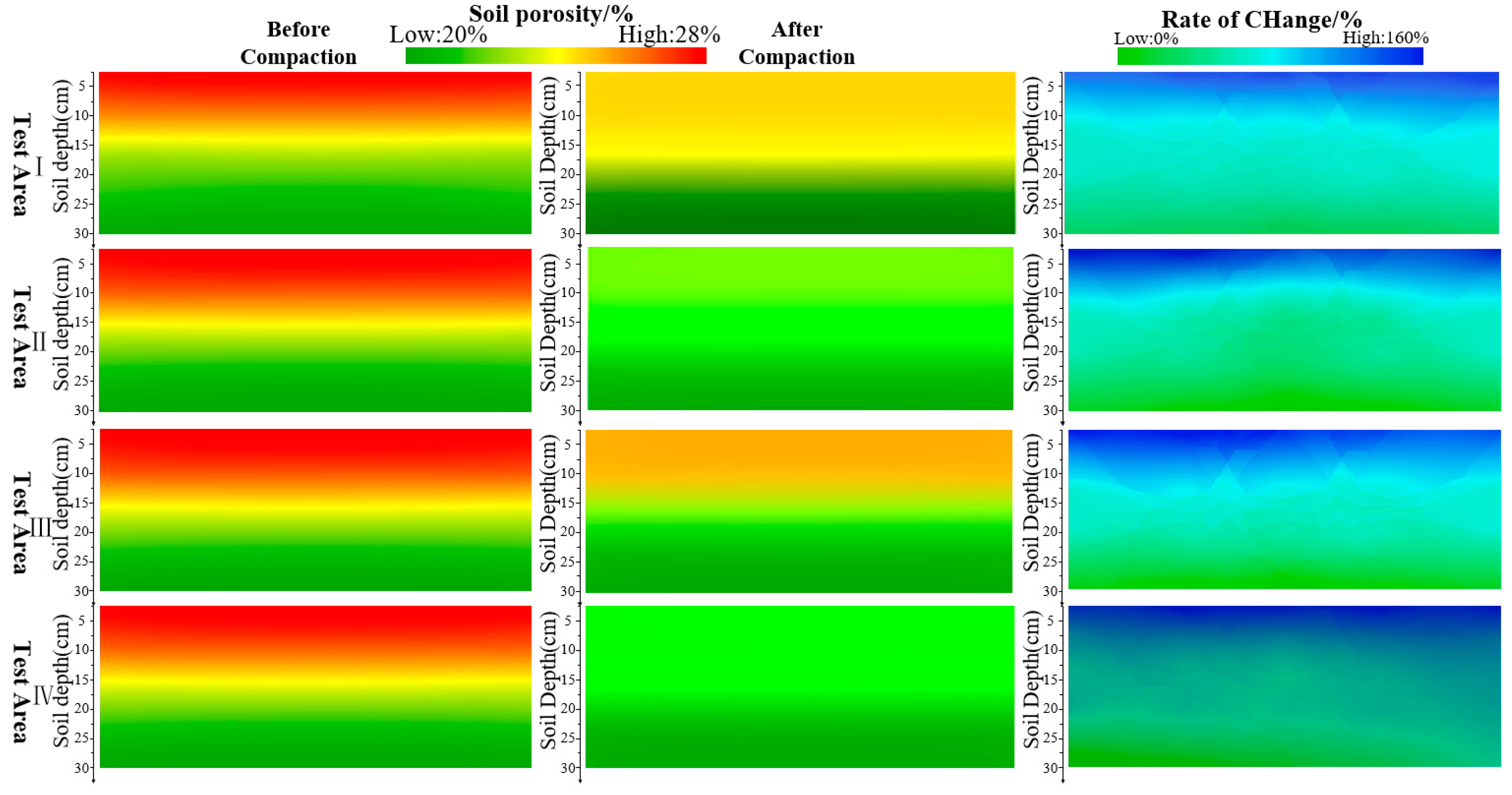
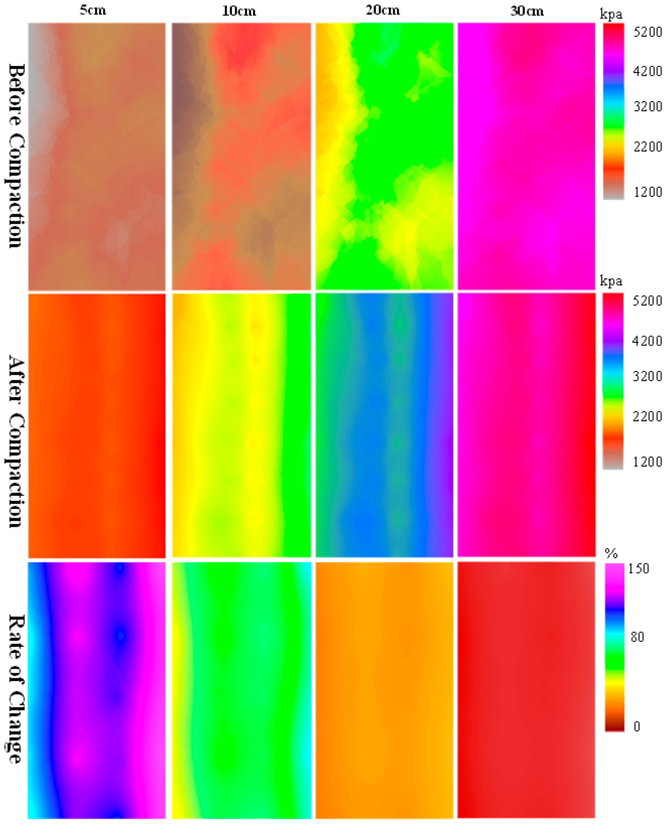
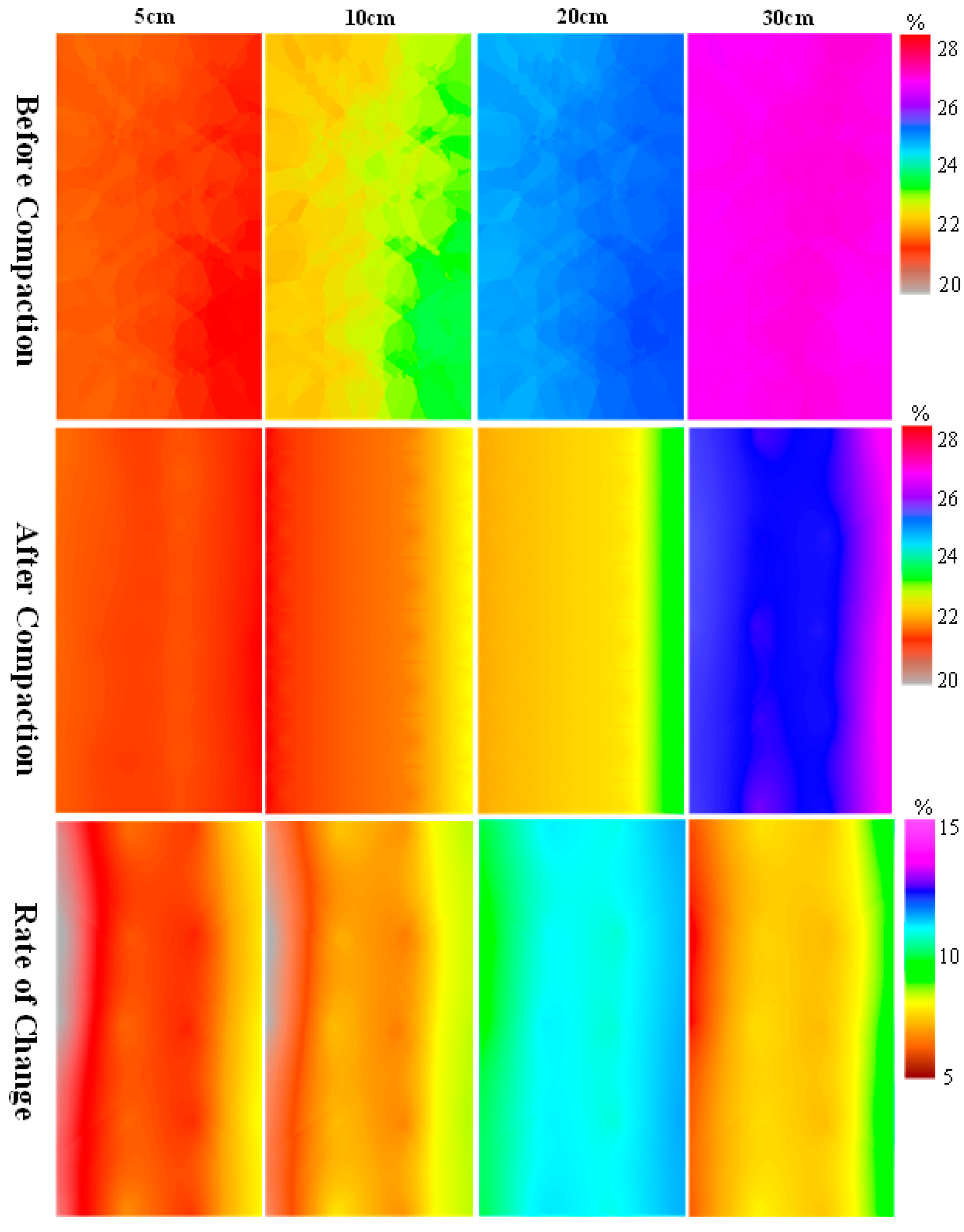
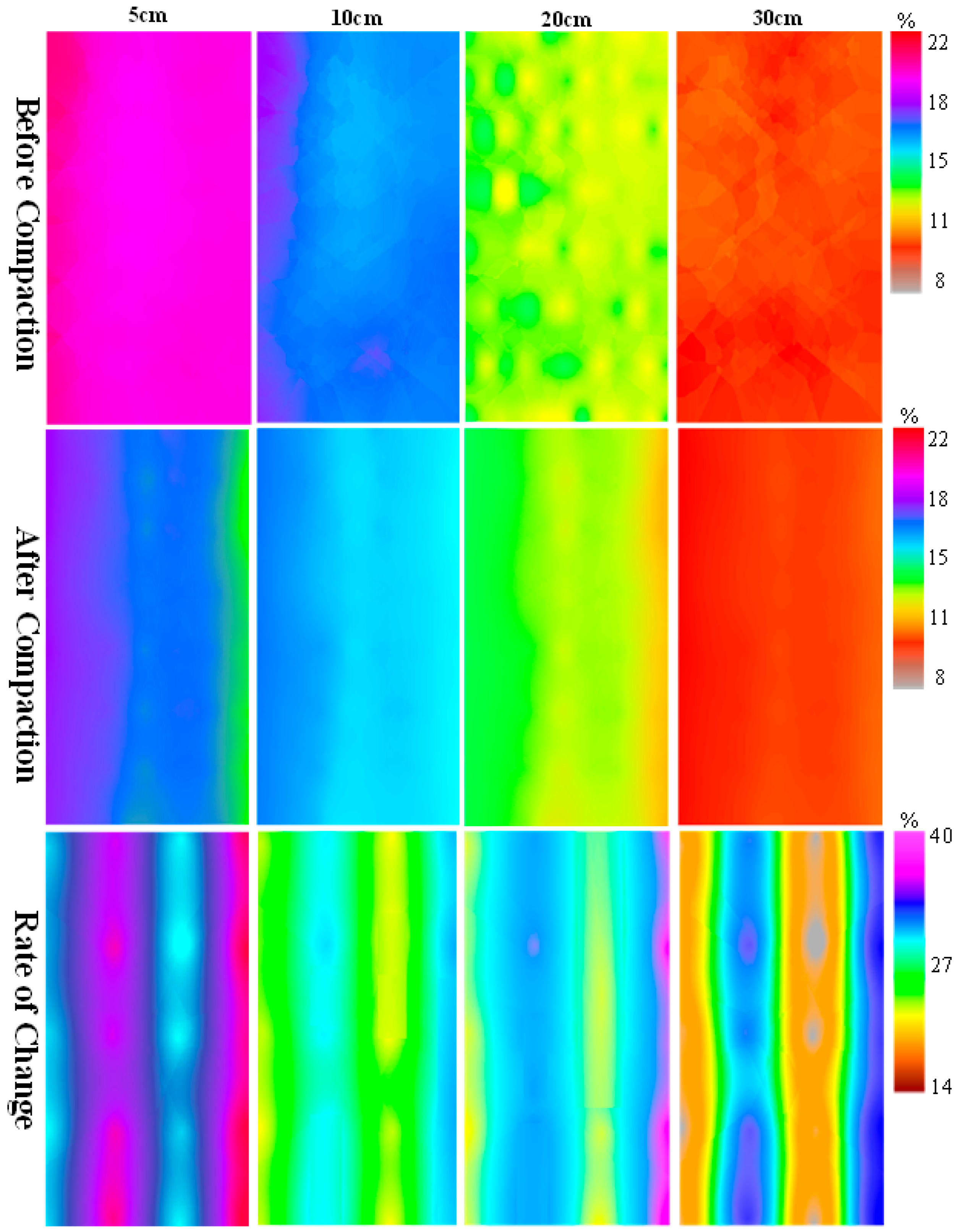
- The heavy-duty fertilizer-spreading unit had a significant compaction effect on the black soil layer, with the greatest change in compactness and porosity in the top-soil layer (at a 5 cm depth), where the rate of change in soil compactness reached 143.49% and the rate of change in soil porosity reached 40.57%. The maximum variation in the water rate was reached at a depth of approximately 20 cm with a maximum value of 13.78%.
- (2)
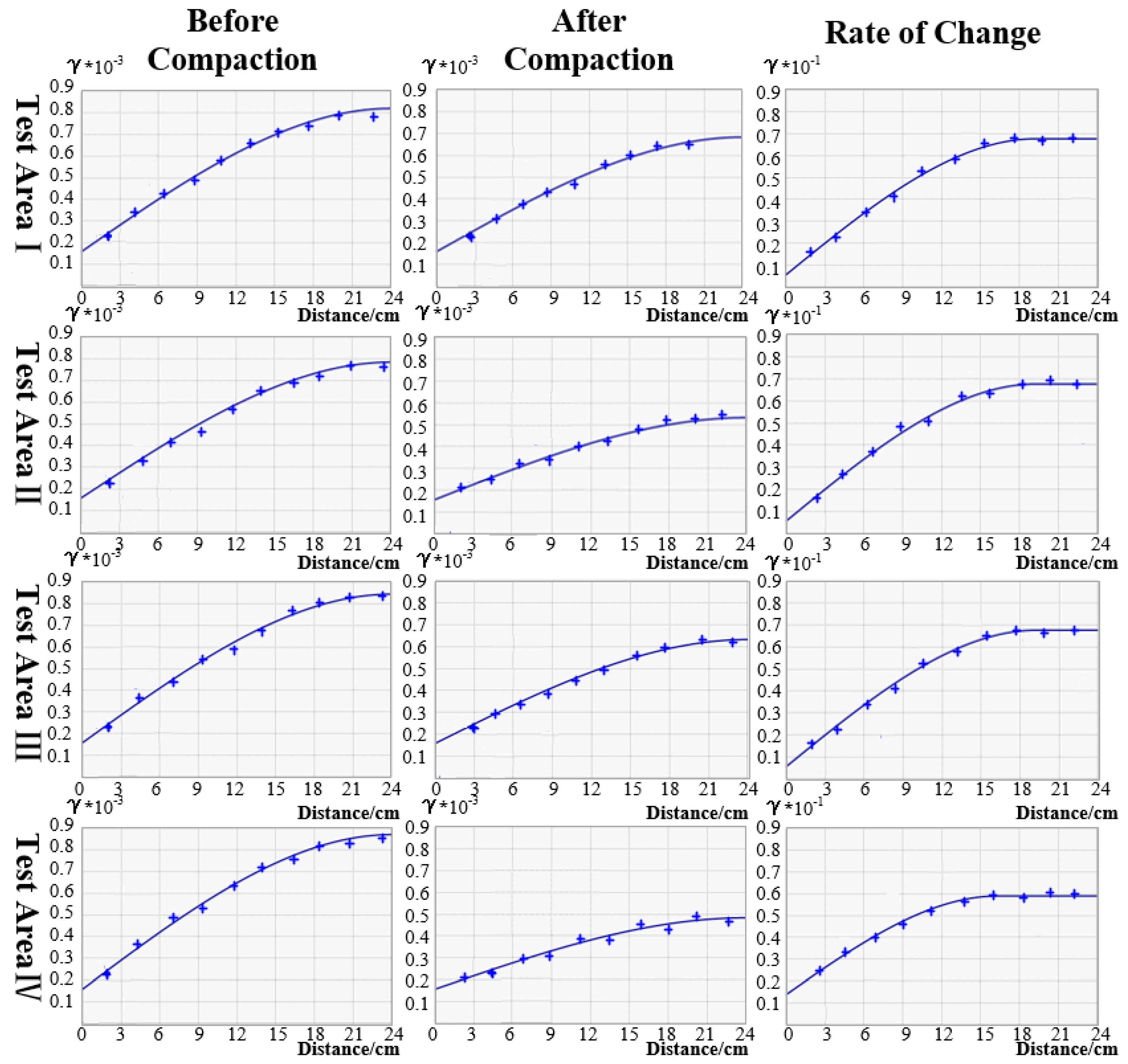
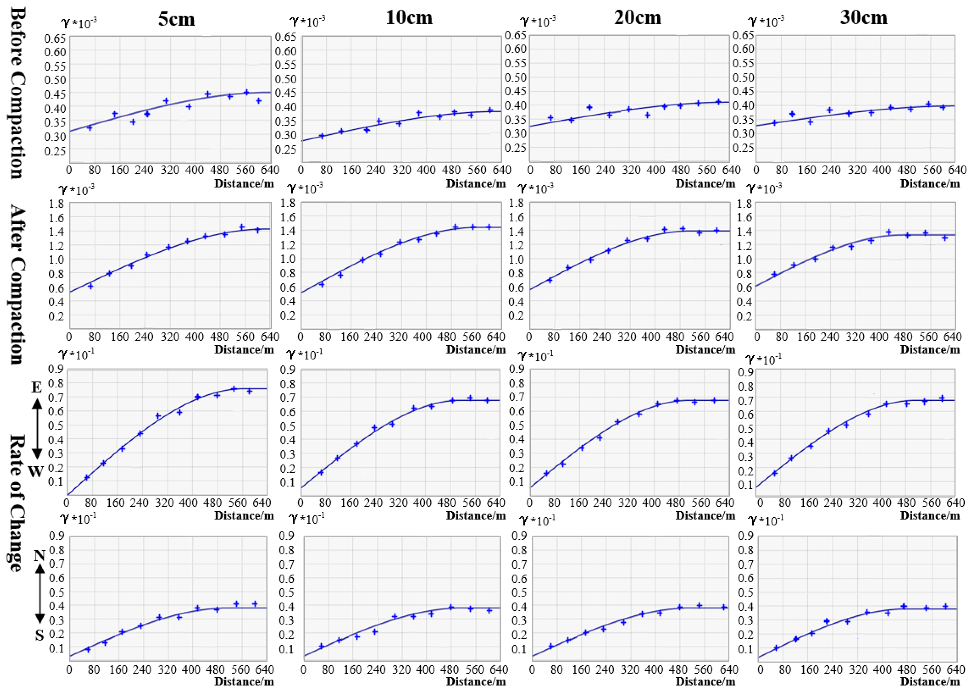
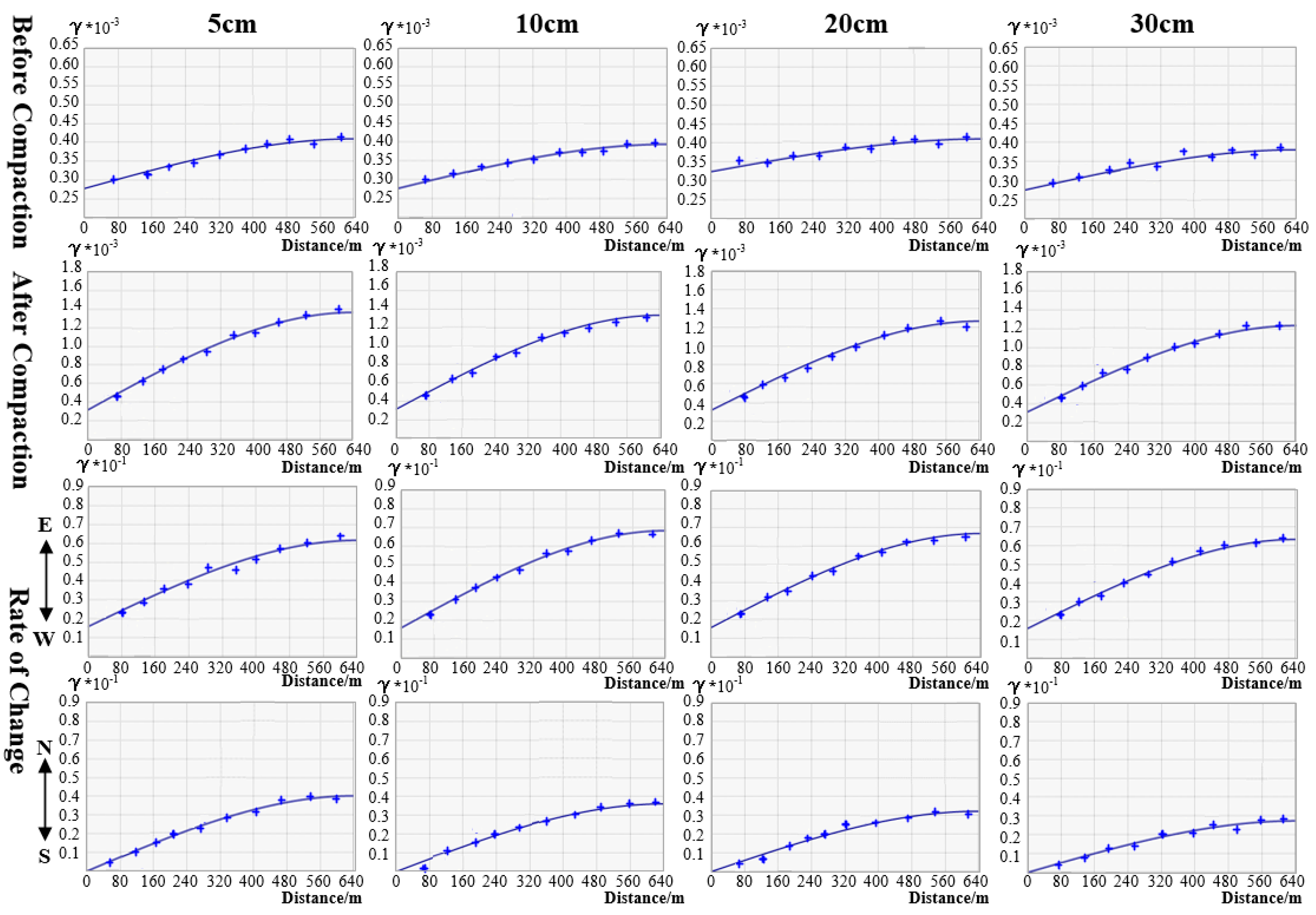
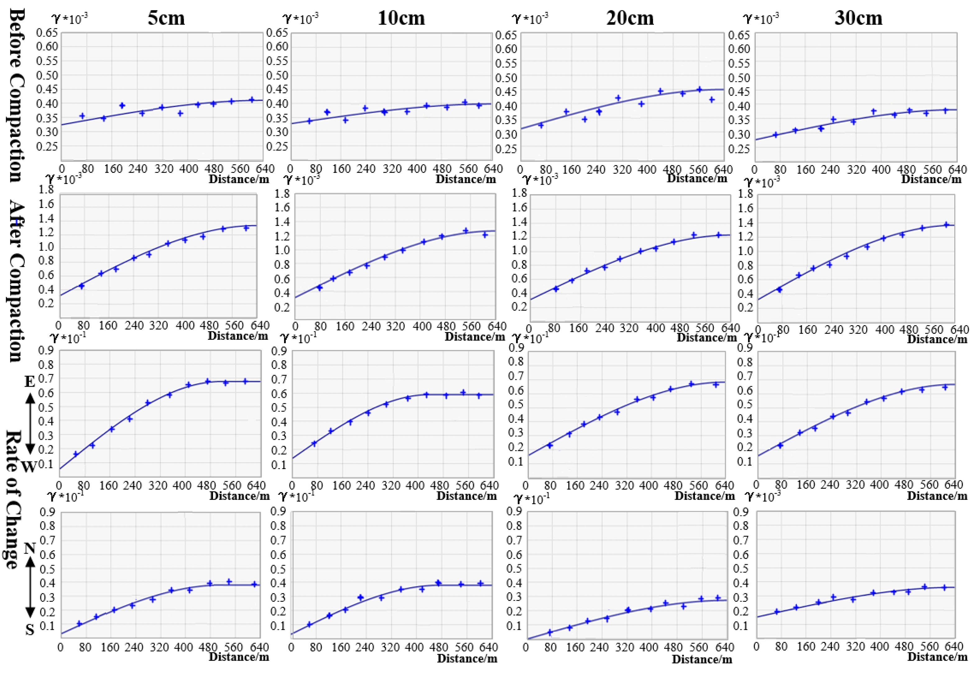
- The results of the analysis of the longitudinal spatial variability show that, as shown in Table 4, the mean values of c0/(c0 + c) for the spatial semi-variance functions of soil compactness, moisture content and porosity of the tillage layer in each test area before compaction were approximately 15%, 19% and 20%, respectively, and after compaction the mean values were approximately 33%, 23% and 30%, respectively, which indicates that compaction by high-power and no-tillage multifunction units leads to a reduction in the longitudinal spatial variability of soil physical parameters in the black soil layer. The mean values of c0/(c0 + c) for the spatial semi-variance functions of soil compactness, moisture content and porosity variability of the tillage layer in each test area were approximately 24%, 14% and 12%, respectively, indicating that the effect of compaction by the heavy spreader unit on soil physical parameters was highly variable in the longitudinal space.
- (3)
- The results of the analysis of lateral spatial variability showed that, as shown in Table 4, the mean values of c0/(c0 + c) of the spatial semi-variance functions of soil compactness, water content and porosity of the tillage layer at each depth before compaction were approximately 80%, 71% and 78%, respectively, and the mean values after compaction were approximately 40%, 23% and 24%, respectively, with the mean values of c0/(c0 + c) along the east–west direction being approximately 8%, 27% and 18%, and the mean values of c0/(c0 + c) along the north–south direction being approximately 9%, 0% and 20%. This indicates that compaction by the high-power and no-tillage multifunction units leads to increased lateral spatial variability of soil physical parameters in the cultivated layer at all depths of the black soil layer, with higher variability in the east–west space for soil physical compactness and porosity, and in the north–south direction for soil moisture content.
Author Contributions
Funding
Acknowledgments
Conflicts of Interest
References
- Wang, X.; Wang, Q.; Li, H.; Li, W.; Niu, Q.; Chen, W. Effect of type induced soil compaction on soil properties and crop root growth under no-tillage system. Trans. Chin. Soc. Agric. Mach. 2017, 48, 168–175. [Google Scholar] [CrossRef]
- Wang, X.; He, J.; Bai, M.; Liu, L.; Gao, S.; Chen, K.; Zhuang, H. The Impact of Traffic-Induced Compaction on Soil Bulk Density, Soil Stress Distribution and Key Growth Indicators of Maize in North China Plain. Agriculture 2022, 12, 1220. [Google Scholar] [CrossRef]
- Qiang, X.; Sun, J.; Ning, H. Impact of Subsoiling on Cultivated Horizon Construction and Grain Yield of Winter Wheat in the North China Plain. Agriculture 2022, 12, 236. [Google Scholar] [CrossRef]
- Acquah, K.; Chen, Y. Soil Compaction from Wheel Traffic under Three Tillage Systems. Agriculture 2022, 12, 219. [Google Scholar] [CrossRef]
- Orzech, K.; Wanic, M.; Załuski, D. The Effects of Soil Compaction and Different Tillage Systems on the Bulk Density and Moisture Content of Soil and the Yields of Winter Oilseed Rape and Cereals. Agriculture 2021, 11, 666. [Google Scholar] [CrossRef]
- Moitzi, G.; Sattler, E.; Wagentristl, H. Effect of Cover Crop, Slurry Application with Different Loads and Tire Inflation Pressures on Tire Track Depth, Soil Penetration Resistance and Maize Yield. Agriculture 2021, 11, 641. [Google Scholar] [CrossRef]
- Lou, S.; He, J.; Li, H.; Wang, Q.; Lu, C.; Liu, W.; Liu, P.; Zhang, Z.; Li, H. Current Knowledge and Future Directions for Improving Subsoiling Quality and Reducing Energy Consumption in Conservation Fields. Agriculture 2021, 11, 575. [Google Scholar] [CrossRef]
- Fu, X.; Shao, M. Improved Soil Sompaction Model and Experimental Study. Trans. Chin. Soc. Agric. Eng. Trans. CSAE 2007, 23, 1–5. [Google Scholar] [CrossRef]
- Thomas, K. A Model for the Prediction of the Contact Area and the Distribution of Vertical Stress below Agricultural Tyres from Readily Available Tyre Parameters. Biosyst. Eng. 2005, 92, 85–96. [Google Scholar] [CrossRef]
- Castioni, G.A.; de Lima, R.P.; Cherubin, M.R.; Bordonal, R.O.; Rolim, M.M.; Carvalho, L.N. Machinery traffic in sugarcane straw removal operation: Stress transmitted and soil compaction. Soil Tillage Res. 2021, 213, 105122. [Google Scholar] [CrossRef]
- Obour, P.B.; Ugarte, C.M. A meta-analysis of the impact of traffic-induced compaction on soil physical properties and grain yield. Soil Tillage Res. 2021, 211, 105019. [Google Scholar] [CrossRef]
- Faloye, O.T.; Ajayi, A.E.; Zink, A.; Fleige, H.; Dörner, J.; Horn, R. Effective stress and pore water dynamics in unsaturated soils: Influence of soil compaction history and soil properties. Soil Tillage Res. 2021, 211, 104997. [Google Scholar] [CrossRef]
- Gemma, G.A. A Web-Enabled GIS Platform for Agricultural Land Use. IOP Conference Series Materials. Sci. Eng. 2020, 803, 012002. [Google Scholar] [CrossRef]
- Yang, W.; Liao, H.; Pan, Z.; Li, X.; Li, T.; Li, J. Research on evaluation of suitability degree of industry transfer in gentle hillside Area in Chongqing based on GIS. Trans. Chin. Soc. Agric. Eng. Trans. CSAE 2015, 31, 244–252. [Google Scholar] [CrossRef]
- Hu, Y.; Deng, L.; Zhang, S.; Ling, J.; Huang, S.; Kuang, X.; Liu, L. Changes of land use and landscape pattern in Xichang city based on RS and GIS. Trans. Chin. Soc. Agric. Eng. Trans. CSAE 2011, 27, 322–327. [Google Scholar] [CrossRef]
- Liu, D.; Peng, L.; Gao, L.; Liu, J.; Sheng, L. Geographic information system (GIS)-based zoning of the suitability of Dendrobium ferruginum cultivation in Yunnan Province. Trans. Jiangsu Agric. Sci. 2017, 45, 227–230. [Google Scholar] [CrossRef]
- Sun, H.; Wei, X.; Liu, W.; Li, D.; Jia, F.; Chen, N.; Sun, X. Evaluation method of cuacreslative effect of soil heavy metal ecological risk based on GIS baseline segmentation and land use unit optimization. Trans. Geol. 2022, 96, 1488–1502. [Google Scholar] [CrossRef]
- John, B.; Das, S. Identification of risk zone area of declining piezometric level in the urbanized regions around the City of Kolkata based on ground investigation and GIS techniques. Groundw. Sustain. Dev. 2020, 11, 100354. [Google Scholar] [CrossRef]
- Abuzaid, A.S.; AbdelRahman, M.A.E.; Fadl, M.E.; Antonio, S. Land Degradation Vulnerability Mapping in a Newly-Reclaimed Desert Oasis in a Hyper-Arid Agro-Ecosystem Using AHP and Geospatial Techniques. Agronomy 2021, 11, 1426. [Google Scholar] [CrossRef]
- Zhang, Y.; Wang, J.; Zhang, J. Study on Interpolation Method of Soil Moisture based on GIS and Statistical Models. Trans. J. Sichuan Norm. Univ. (Nat. Sci.) 2019, 42, 703–710. [Google Scholar] [CrossRef]
- Liu, Y.; Ye, C.; Wang, K. Soil moisture prediction technique in Beijing supported by RS and GIS techniques. Trans. Chin. Soc. Agric. Mach. 2008, 24, 155–160. [Google Scholar] [CrossRef]
- Qaio, J.; Zhang, D.; Zhang, H.; Zhang, B.; Chen, H.; Chen, L.; Zheng, D.; Sun, J. Effects of soil compaction by various tractors on soil pene tration resistance and soybean yields. Trans. Chin. Soc. Agric. Eng. Trans. CSAE 2019, 35, 26–33. [Google Scholar] [CrossRef]


| Tractor | Number of Engine Cylinders | Power Rating | Operating Speed Range | Length × Width × Height | Overall Vehicle Mass |
| 6 | 150.8 kW | 1600–2100 r/min | 5.5 × 2.44 × 3.18 m | 7770 kg | |
| Tire | Position | Specification | Wheel Diameter | Tire Pressure | Grounding Area |
| Front | 420/90 R30 | 762.00 mm | 140 kPa | 2522 cm2 | |
| Rear | 480/80 R46 | 1168.4 mm | 200 kPa | 3234 cm2 | |
| No-Till Seeders | Working Width | Weight | Capacity | Matching Power | Trencher Ground Clearance |
| 6.1 m | 6500 kg | 405 L/m | 104 kW | 20.3 cm |
| Test Area | Soil Depth (cm) | Soil Compactness | Soil Water Content | Soil Porosity | ||||||
|---|---|---|---|---|---|---|---|---|---|---|
| Before (kPa) | After (kPa) | Rate of Change (%) | Before (kPa) | After (kPa) | Rate of Change (%) | Before (kPa) | After (kPa) | Rate of Change (%) | ||
| Ⅰ | 5 | 888.23 | 1595.86 | 79.67 | 21.92 | 20.61 | 5.98 | 20.92 | 14.96 | 28.49 |
| 10 | 1343.75 | 1918.38 | 42.76 | 22.57 | 21.23 | 5.94 | 18.37 | 14.87 | 19.05 | |
| 15 | 1943.87 | 2418.23 | 24.40 | 23.44 | 21.74 | 7.25 | 14.63 | 12.34 | 15.65 | |
| 20 | 2588.91 | 3078.72 | 18.95 | 24.84 | 22.11 | 10.99 | 13.02 | 10.27 | 21.12 | |
| 30 | 4640.66 | 4738.58 | 2.11 | 25.39 | 23.41 | 7.80 | 11.46 | 9.75 | 14.92 | |
| II | 5 | 836.61 | 1848.91 | 121.56 | 22.06 | 20.58 | 6.69 | 21.11 | 13.24 | 37.28 |
| 10 | 1348.08 | 2236.46 | 65.97 | 22.69 | 21.03 | 7.33 | 19.35 | 13.47 | 30.37 | |
| 15 | 2066.49 | 2893.09 | 40.00 | 23.93 | 21.23 | 11.30 | 15.61 | 11.17 | 28.47 | |
| 20 | 2667.47 | 3200.96 | 20.24 | 25.09 | 21.81 | 13.05 | 13.11 | 8.98 | 31.51 | |
| 30 | 4524.26 | 4886.20 | 8.36 | 25.84 | 23.27 | 9.94 | 11.89 | 8.70 | 26.79 | |
| III | 5 | 721.38 | 1428.33 | 98.41 | 21.83 | 20.65 | 5.39 | 20.86 | 15.04 | 27.87 |
| 10 | 1312.20 | 1968.30 | 50.30 | 22.52 | 21.20 | 5.86 | 19.32 | 14.56 | 24.66 | |
| 15 | 1941.38 | 2407.31 | 23.97 | 24.07 | 21.69 | 9.86 | 15.71 | 12.34 | 21.45 | |
| 20 | 2066.49 | 2500.45 | 21.31 | 25.28 | 22.44 | 11.25 | 13.07 | 10.02 | 23.34 | |
| 30 | 4589.72 | 4865.10 | 6.20 | 26.35 | 24.10 | 8.55 | 11.62 | 9.58 | 17.65 | |
| IV | 5 | 841.96 | 2050.13 | 143.49 | 21.68 | 20.28 | 8.30 | 21.62 | 12.85 | 40.57 |
| 10 | 1317.12 | 2370.86 | 80.00 | 23.39 | 19.88 | 9.16 | 19.61 | 12.62 | 35.64 | |
| 15 | 2037.74 | 2863.22 | 40.51 | 23.61 | 20.78 | 11.99 | 15.88 | 10.37 | 34.69 | |
| 20 | 2854.82 | 3602.82 | 26.20 | 24.96 | 21.52 | 13.78 | 13.21 | 8.18 | 38.06 | |
| 30 | 4563.73 | 5173.30 | 13.36 | 25.92 | 23.31 | 10.07 | 11.71 | 7.96 | 32.22 | |
| c0/(c0 + c) | Degree of Spatial Autocorrelation |
|---|---|
| <25% | Strong |
| 25–75% | Moderate |
| >75% | Weak |
| Variable Name | Vertical c0/(c0 + c) | Horizontal c0/(c0 + c) | |||||
|---|---|---|---|---|---|---|---|
| Before Compaction | Before Compaction | Rate of Change | Before Compaction | Before Compaction | After (E−W) | After (S−N) | |
| Soil Compactness | 15% | 33% | 24% | 80% | 40% | 8% | 9% |
| Strong | Moderate | Strong | Weak | Moderate | Strong | Strong | |
| Soil Water Content | 19% | 23% | 14% | 71% | 23% | 27% | 0% |
| Strong | Strong | Strong | Moderate | Strong | Moderate | Strong | |
| Soil Porosity | 20% | 30% | 12% | 78% | 24% | 18% | 20% |
| Strong | Moderate | Strong | Weak | Strong | Strong | Strong | |
Publisher’s Note: MDPI stays neutral with regard to jurisdictional claims in published maps and institutional affiliations. |
© 2022 by the authors. Licensee MDPI, Basel, Switzerland. This article is an open access article distributed under the terms and conditions of the Creative Commons Attribution (CC BY) license (https://creativecommons.org/licenses/by/4.0/).
Share and Cite
Li, W.; Song, Z.; Yang, M.; Yang, X.; Luo, Z.; Guo, W. Analysis of Spatial Variability of Plough Layer Compaction by High-Power and No-Tillage Multifunction Units in Northeast China. Agriculture 2022, 12, 1530. https://doi.org/10.3390/agriculture12101530
Li W, Song Z, Yang M, Yang X, Luo Z, Guo W. Analysis of Spatial Variability of Plough Layer Compaction by High-Power and No-Tillage Multifunction Units in Northeast China. Agriculture. 2022; 12(10):1530. https://doi.org/10.3390/agriculture12101530
Chicago/Turabian StyleLi, Wenjie, Zhenghe Song, Minli Yang, Xiao Yang, Zhenhao Luo, and Weijie Guo. 2022. "Analysis of Spatial Variability of Plough Layer Compaction by High-Power and No-Tillage Multifunction Units in Northeast China" Agriculture 12, no. 10: 1530. https://doi.org/10.3390/agriculture12101530
APA StyleLi, W., Song, Z., Yang, M., Yang, X., Luo, Z., & Guo, W. (2022). Analysis of Spatial Variability of Plough Layer Compaction by High-Power and No-Tillage Multifunction Units in Northeast China. Agriculture, 12(10), 1530. https://doi.org/10.3390/agriculture12101530


