Article

Characterization and Mapping of the Potential Area of Oil Palm Using Multi-Criteria Decision Analysis in a Geographic Information Systems Environment

1
ICAR-Indian Institute of Oil Palm Research, Pedavegi 534450, Andhra Pradesh, India
2
ICAR-National Bureau of Soil Survey and Land Use Planning, Nagpur 440033, Maharashtra, India
3
ISRO-Mahalanobis National Crop Forecasting Centre, New Delhi 110012, India
4
ICAR-Indian Institute of Soil Science, Bhopal 462038, Madhya Pradesh, India
5
Institute of Oil Seeds Research, Hyderabad 500300, Telangana State, India
*
Author to whom correspondence should be addressed.
Agriculture 2024, 14(7), 986; https://doi.org/10.3390/agriculture14070986
Submission received: 16 February 2024 / Revised: 9 May 2024 / Accepted: 21 May 2024 / Published: 25 June 2024
(This article belongs to the Section Digital Agriculture)

Abstract

:
This study presents a GIS-based Multi-Criteria Decision Analysis (MCDA) spatial model to assess land suitability for oil palm (OP) cultivation in rainfed conditions. Initially, twelve parameters, viz., rainfall, number of rainy days, mean temperature, RH, ground water level, soil pH, salinity, soil depth, surface texture, stoniness, slope, and drainage, were selected for assessing OP suitability in one of the states (Kerala). However, subsequent ground verification revealed significant discrepancies, which prompted refining the model by focusing on key parameters with greater accuracy and relevance. Accordingly, only five the most critical parameters affecting OP cultivation under rainfed conditions were selected through the rank sum method, and weights were assigned ac-cording to their significance. This study was aimed at creating a comprehensive tool for informed decision making in agricultural planning. District-level spatial data from reliable sources were utilized for Multi-Criteria Decision Analysis. Thematic rasters, representing key factors influencing land suitability, were created in a GIS. Utilizing MCDA techniques, a digital suitability map was generated in ArcGIS 10.3, delineating three distinct classes over an extensive area of 10.5 million hectares. Further, with an aim to focus on actual locations that can be readily planted with oil palm, the suitable locations identified were restricted to eight selected land use/land cover (LULC) classes. This strategic limitation aimed to facilitate the expansion of OP cultivation exclusively to areas deemed most suitable based on the identified criteria. The validation of this developed model involved comparing the suitability map generated with the performance of existing oil palm plantations across diverse locations. The reasonable similarity between the model’s predictions and real-world plantation outcomes validated the effectiveness of this MCDA spatial model. This model not only helps identify suitable locations for rainfed oil palm cultivation but also serves as a valuable tool for strategic decision making in agricultural land use planning.

1. Introduction

Ensuring global food security amidst the challenges of increasing demand for food and water, driven by population growth and dietary shifts, still remains a critical concern. In this context, India’s reliance on imported edible oils underscores the urgency of addressing the gap between demand and domestic production. The period from 2020 to 2021 witnessed India importing 13.352 million tonnes of edible oils, amounting to USD 10 billion, with palm oil constituting a significant portion at 56% of the total [1]. This heavy reliance on imports, particularly of crude palm oil (CPO) sourced mainly from Malaysia and Indonesia [2], reflects the country’s struggle to meet its own edible oil requirements despite being a significant consumer and importer.
Over the past decade, India’s domestic production of edible oils has fallen short of demand, exacerbating the need for imports [3]. To bridge this gap, the expansion of oil palm cultivation emerges as a viable strategy, given its potential for high yields ranging from 4 to 6 tonnes of oil per hectare per year [2]. While oil palm cultivation was initially introduced for commercial purposes in the late 20th century, its widespread adoption has primarily occurred in regions with access to irrigation, owing to its requirement for annual rainfall ranging from 1800 to 2000 mm [4].
Recognizing the potential for oil palm cultivation to bolster the domestic production of edible oils, expert committees convened by the Ministry of Agriculture, Government of India, have identified approximately 1.93 million hectares across 19 states as suitable for oil palm cultivation through physical surveying [5]. No spatial data sets were used for identifying these areas. The suitable areas identified in this method encompass both irrigated and rainfed regions, reflecting the need to explore diverse cultivation methods to optimize yield and ensure sustainable production.
However, observed variations in the productivity of fresh fruit bunches (FFB) among existing oil palm plantations underscore the critical influence of environmental factors such as rainfall, temperature, humidity, etc., under both rainfed and irrigated conditions [6]. This variability is not unique to India but is also evident in countries like Malaysia, where commercial plantations exhibit differing levels of productivity in response to varying weather conditions [7]. Thus, the strategic deployment of oil palm to locations aligned with its climatic and soil requirements becomes imperative for maximizing yield and ensuring the sustainability of cultivation practices. In Madagascar, employing MCDA techniques, suitability maps were generated to guide decision-making for the sustainable agricultural expansion of oil palm [8]. This investigation presents a structured methodology to enhance land use planning and advocate for environmentally conscious practices [8].
Land suitability evaluation (LSE) serves as a crucial tool in guiding the selection of appropriate land for oil palm cultivation, considering factors such as climate, soil characteristics, water availability, and environmental degradation [9]. By matching these land characteristics with the requirements of the crop, LSE ensures optimal land use while minimizing negative environmental impacts [10].
To this end, utilizing advanced technologies such as Geographic Information Systems (GISs) and remote sensing can aid in identifying suitable locations for rainfed oil palm cultivation. Many researchers have found that MCDA is a promising method in agricultural land suitability modeling [11,12,13]. Further, the integration of GIS with Multi-Criteria Decision Analysis (MCDA) enhances the efficiency of land suitability modeling by enabling the analysis of various parameters, such as soil quality, climate suitability, and topography. Theoretically, an MCDA model is applied by analyzing several important parameters, like soil, climate, topography, etc., with a set of criteria and a scoring system, supported with a good understanding of local biophysical restraints [10]. The GIS quickly exhibits relationships, trends, and patterns between data sets, for efficient evaluation [6].Modeling has been used as a tool to assess suitable areas for oil palm, helping in area expansion [14]. A GIS helps in storing, analyzing, and retrieving large sets of spatial and non-spatial data [15], and if it combines with MCDA, the process becomes more efficient. Also, many research works have reported that, through utilizing spatial data, GIS enables land evaluation through map analysis [16,17,18]. Spatial data layers of the selected criteria of the model are combined through MCDA by giving weightage to each criterion [19] emphasized the need for generating alternatives for each criterion, along with ranks for more functionality, helping to better decision making [20]. Different research works have used an MCDA technique in different crops for land suitability assessment, viz., tobacco [21]; tea [22]; maize [23]; and Moringa [24]. Most suitable zones for a crop can be located through GIS-based mapping [25,26]. Therefore, by analyzing spatial data sets of climate, soil, and physiographic features, potential cultivation sites can be pinpointed for rainfed oil palm cultivation. This would help in reducing reliance on irrigation and thereby minimizes pressure on groundwater resources.
Moreover, the adoption of MCDA in land suitability modeling facilitates informed decisionmaking by analyzing multiple criteria and assigning weights to each criterion based on their importance [26]. This approach enables policymakers and stakeholders to identify the most suitable areas for oil palm cultivation, taking into account various factors, such as soil fertility, water availability, and environmental sustainability [10]. In addition to its potential for expanding oil palm cultivation, GIS-based mapping can also aid in assessing the actual area available for cultivation by incorporating spatial information on land use and land cover (LULC) [26]. By delineating suitable cultivation zones and estimating area statistics under different classes of suitability, policymakers can make informed decisions regarding land allocation and resource management.
Furthermore, the validation of the MCDA model through comparison with existing plantation yields ensures the reliability and accuracy of the model in predicting suitable cultivation areas. By validating the model’s performance against real-world data, policymakers can gain confidence in its ability to guide sustainable oil palm cultivation practices.
So far, no such analysis has been carried out in India for identifying suitable locations for rainfed oil palm cultivation. Therefore, the development of a GIS-based MCDA model holds immense potential for facilitating the expansion of oil palm cultivation in rainfed areas of India. Against this back drop, the present study aimed to demonstrate that (1) the MCDA model (with identified critical parameters, weights, and classes) is valid for selecting suitable areas for rainfed oil palm cultivation in the tropics and semi-arid tropics; (2) expand oil palm cultivation to non-traditional areas to secure the livelihoods of local people through this decision tool; (3) ensure the sustainable production of oil palm; and (4) provide guidance for policy decisions to prevent land degradation under oil palm. 1.The MCDA model (with identified critical parameters, weights and classes) is valid for selecting suitable areas for rainfed cultivation of oil palm in tropics and semi arid tropics 2. Expanding oil palm cultivation to non-traditional areas for livelihood security of local people through this decision tool 3.Ensuring sustainable production of oil palm and4.Guidance for policy decisions to prevent land degradation under oil palm.

2. Materials and Methods

2.1. Study Area

As the present investigation is aimed at delineating suitable areas for the rainfed cultivation of OP, the study area was selected based on the mean annual rainfall (≥1800 mm) of the district (50 years normal) which is considered as the primary attribute by many workers for OP cultivation [4]. Accordingly, states with more than 90 per cent of districts bestowed with >1800 mm rainfall were selected and comprised as study area for the rainfed cultivation of oil palm [5]. So, the states and union territories (UTs) selected (a total of 15) for assessing oil palm suitability under rainfed cultivation were Andaman and Nicobar Islands, Arunachal Pradesh, Assam, Dadra and Nagar Haveli, Daman and Diu, Goa, Himachal Pradesh, Kerala, Manipur, Meghalaya, Mizoram, Nagaland, Puducherry, Sikkim and Tripura (Figure 1).

2.2. Selection of Critical Parameters (Factors), Classification, Weights and Scores

From our literature review, surveying OP plantations, and through expert consultations, five parameters, viz., 1. annual rainfall, 2. number of months with <15 °C mean minimum temperature, 3. slope of the terrain, 4. soil depth, and 5. length of continuous dry period (number of days) were selected as the most critical parameters (factors) for assessing land suitability for oil palm cultivation under rainfed conditions. It is reported that every 100 mm of water deficit reduces yield by 8–10% in the first year, and 3–4% in the second year after the stress event [27]. Further, prolonged low minimum temperatures of less than 21 °C were found to increase the abortion of inflorescences before anthesis and slow down the ripening of fruit bunches in Honduras [28]. A similar response was noticed in China where the minimum temperatures are commonly below 18 °C. The growth rate of young seedlings is inhibited at temperatures of 15 °C or lower. The growth of seedlings starts at about 17.5 °C and increases three times at 20 °C and seven times at 25 °C [29]. There are reports from Sumatra that palms planted above 500 m come into bearing up to one year later than palms in the lowlands. Oil palm is not recommended on sloppy lands because of the serious risk of erosion, which leads to a failure to supply required water and nutrients. So, only lands with <20° slope were considered under different classes of suitability. The occurrence of dry periods intermittently was not very impactful. But, if a dry period is continuous, there are reports of lower yields. The data consisted of four classified vector data sets. Each factor was given a proper weight and each class a score based on the rank sum method as described by Malczewski [25] in the following equation. They were ranked as per their importance by assigning weights [30] and then normalized by the sum of their weights. The normalized weights were estimated by Equation (1).
W ( j ) = ( n r ( j ) + 1 ) k = 1 n ( n r ( k ) + 1 )
W(j) = normalized weight for jth factor
N = number of factors under consideration
k = 1 … 2 … 3 … n;
r(j) = rank position of each factor
Then, each parameter was reclassified into four sub-classes with scores under viz., highly suitable, moderately suitable, marginally suitable and not suitable categories as per the FAO [31] guidelines of land suitability classes and as suggested by Djaenudin et al. [32] (Table 1).
The total score for each unit of land suitability was estimated using Equation (2).
R s = i = 0 n W i x S i j
where:
Rs = totalscore for each unit of land suitability;
Wi = weight for ith map;
Sij = score for jth class of ith map.
The total score of suitability ranges between 0 and 9 for each factor, and it is divided among the four classes of suitability (Table 2). The scores of each suitability class were different for each parameter depending upon its influence on OP performance. The above suitability classes were used as inputs in MCDA.

2.3. Spatial Data Sources

Meteorological data on annual rainfall (1950–2000) and minimum temperature (1969 to 2008) were sourced from IMD Pune, soil parameter data (soil depth at 1:250,000 scale) were obtained through physical sampling and analysis, and soil resource mapping was carried out by ICAR-NBSS & LUP, Nagpur. Slope data were generated from a Shuttle Radar Topography Mission (SRTM) digital elevation model (DEM) (30 m). A land use and land cover (LULC) map generated during 2017–18 through the interpretation of the multi-temporal AWiFS Dataset with 18 classes by ISRO-NRSC was used for area computations.

2.4. Methodology Adopted

2.4.1. Development of Thematic Rasters

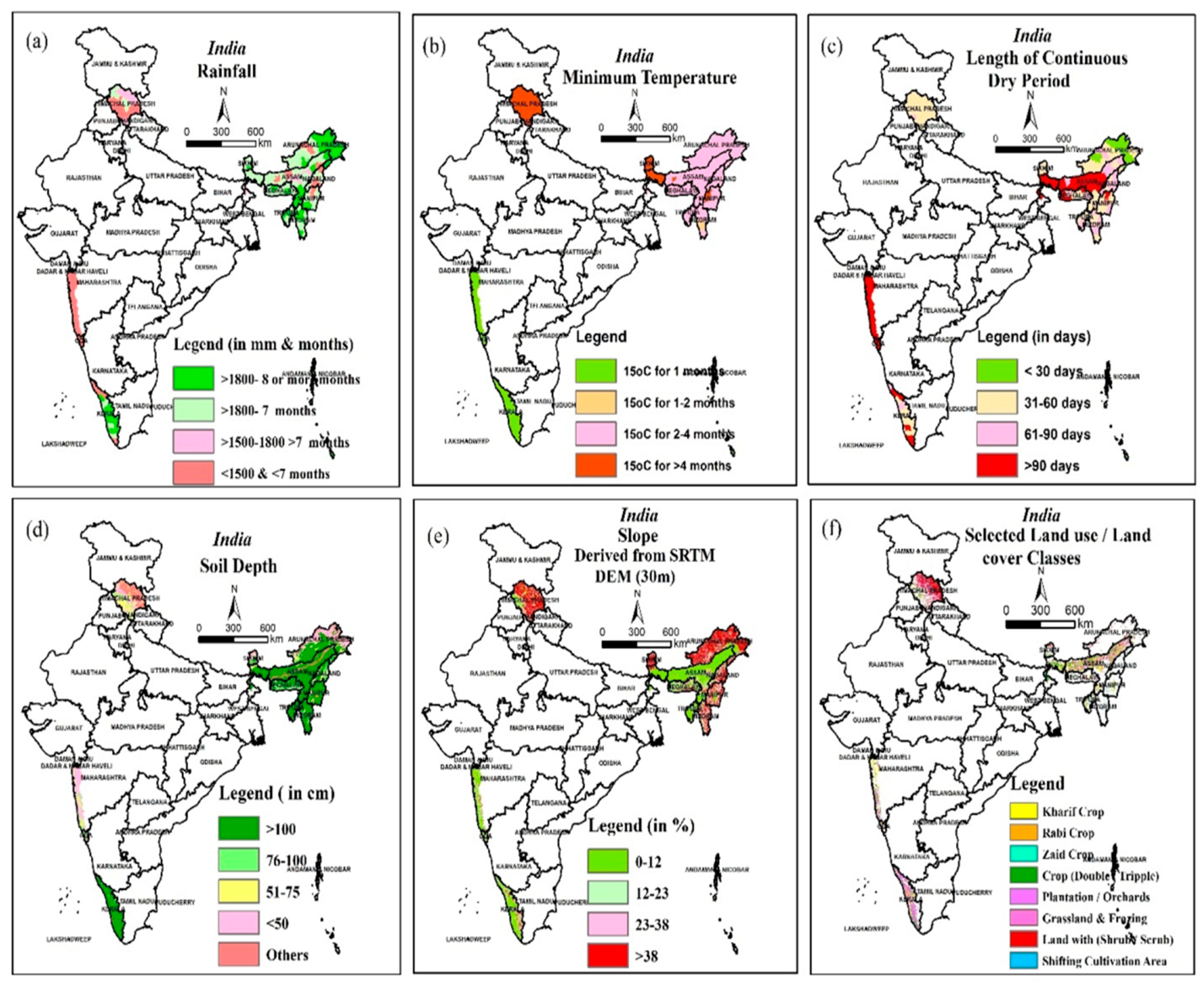
Thematic maps were developed for each parameter and they were converted to rasters through using the ‘vector to raster conversion tool’ in ArcGIS 10.3 [33] (ESRI, 2015) and resampled to a 30 m spatial resolution (Figure 2).

2.4.2. GIS-Based Modeling for Oil Palm Suitability Using MCDA

The thematic rasters developed for each parameter were subsequently stacked in a GIS-based model along with weights for main parameters and scores for sub-classes. Weighted overlay analysis was applied in this stack of rasters under an ArcGIS environment. Input parameters, their theme weights and class scores are presented in Table 2. The model output raster was reclassified to develop the suitability maps for OP with highly suitable, moderately suitable, marginally suitable and non-suitable classes.

2.5. Area Computations

Through the area computation techniques of the GIS, initially, the modeled suitable area in each state (district-wise) of study area was estimated under three different categories (HS, MoS, and MaS). Subsequently, the potential suitable areas for OP cultivation were modeled by selecting areas under eight specified LULC classes, viz., kharif crop, rabi crop, zaid crop, double/triple crop, plantation/orchards, grassland/grazing, land with shrub/scrub, and shifting cultivation area.

2.6. Model Validation

After delineating potential suitable areas under rainfed conditions, the accuracy of model estimates was compared with the production levels of existing OP plantations in the Kerala and Arunachal Pradesh states. The yield levels of existing plantations were collected at district level and compared with that of suitability classes derived from the study for validating the model.

Schema of Methodology

The entire methodology used to model suitable areas for OP cultivation under rainfed conditions, explained above, is presented in the following schema (Figure 3).

3. Results

3.1. Suitable States and Constraints

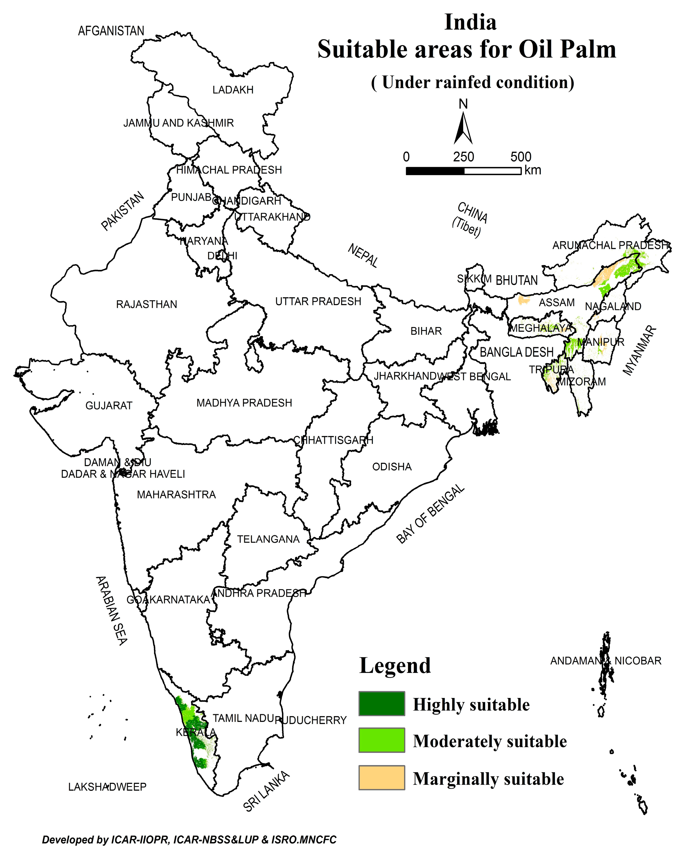
From the MCDA model-derived map, suitable areas for oil palm cultivation under rainfed conditions were observed only in nine states, viz., Andaman and Nicobar Islands, Arunachal Pradesh, Assam, Kerala, Manipur, Meghalaya, Mizoram, Nagaland and Tripura. The remaining six states, viz., Himachal Pradesh, Sikkim and the union territories of Goa, Dadra and Nagar Haveli, and Daman and Diu did not indicate any suitable area for rainfed oil palm cultivation(Figure 4).
This specifies that apart from rainfall, other critical parameters also played a key role in constraining OP cultivation in these locations. From thematic rasters, it could be observed that in Himachal Pradesh and Sikkim, slope, low minimum temperature, and low soil depth influenced OP suitability profoundly.
Oil palm is generally not recommended on sloppy lands because of serious risks of erosion, which leads to a failure to supply required water and nutrients. Pirker et al. [34] opined that slopes above 25° should not be planted with OP at all. Paramananthan [35] considered lands with >20°slope as unsuitable for OP cultivation. Reports from the Sumatra state that palms planted above 500 m come into bearing up to one year later than palms in the lowlands [36].
Corley and Tinker [29] opined that the average temperature of coldest month should not fall below 15 °C. This may account for the very irregular distribution of bunch yield in Honduras where 90% of the crop is harvested in seven months of the year (June to December) [37].
Though oil palm is not very demanding with respect to soil characteristics [34], soil depth, the permanent feature of soil, is very critical, as it affects moisture retention, and root proliferation and provides better anchorage. In OP, most of the roots occur at 40 cm soil depth [36]. The root biomass in an eight-year-old plantation was estimated as 12.57 t/ha, and maximum root biomass was observed within 40 cm depth, and it showed a constant decline from 40 to 100 cm depth in soil [38]. The total fresh biomass of OP trees ranges between 1.5 and 2 tonnes when they reach 20 years of age [39]. In Malaysia, yields of >30 t fruit bunches ha−1 have been reported on most soil types, apart from shallow soils, which cause problems such as reduced root proliferation, increased susceptibility to drought and waterlogging, and the risk of palms falling over [40,41,42]. If a dry period is continuous, there are reports of lower yields in OP [43]. Lim et al. [44] opined that moisture stress is at its minimum if the length of the continuous dry period is limited. Kee [45] reported that on the east coast of Malaysia, prolonged dry spells for 3–4 months (January to April) followed by year end floods seriously limit OP performance.
Accordingly, rainfall distribution, length of continuous dry period and soil depth are the limiting factors in Goa, Dadra and Nagar Haveli, and Daman and Diu. The yield profile of OP varies substantially in different parts of West Malaysia mainly due to rainfall and dry season [40]. The duration and intensity of moisture stress adversely affect FFB production [43], as inflorescence production is continuous year-round. When the moisture stress exceeds 400 mm/yr, its negative effect on floral initiation increases [42]. Areas with water deficits of >400 mm year−1 are considered unsuitable for OP production. Highly suitable areas were recorded only in the state of Kerala as it could meet all the requirements.

3.2. Area under Different Classes of Suitability

In India, 10.478 Mha (3.2% of the TGA) was found suitable for the RF cultivation of OP in nine states. After restricting the area under selected eight LULC classes, the extent of the suitable area reduced to 4.237 Mha (Figure 5). Out of this, 22 per cent is under the HS class, 26% is under the MoS class and the remaining 52% is under the MaS class. The HS area is available only in Kerala and Andaman and Nicobar islands, which are situated closer to the equator (between 0– and 10°latitude). The remaining seven states found suitable for RF cultivation of OP are situated in the NE corner of India, with a mountainous territory.

3.3. State-Wise Potential Areas

3.3.1. North-Eastern States

With the predominance of the humid sub-tropical climate, highly suitable areas are absent in northeastern India. In the state of Arunachal Pradesh, 0.20 Mha of MoS and 0.054 Mha of MaS area is available. Moderately suitable areas are mainly located in the Lohit, Lower Dibang Valley, and East Siang districts (Figure 5 and Figure 6a). A high slope, low soil depth, and low minimum temperature are the major limiting factors in this state.
In Assam, 0.27 Mha of moderately suitable area is available in the Cachar, Karimganj, Hailakandi and N.C Hills districts (Figure 5 and Figure 6b). A length of continuous dry period of more than 90 days and the low mean minimum temperature (<15 °C) for 2 to 4 months, are the major constraints in this state. In Manipur, only 5690 ha of MoS area is available in the Churchandapur district. All the remaining all area is under the marginally suitable category only (Figure 5 and Figure 6c). The high slope, longer continuous dry period, and low minimum temperature are the major limiting factors for OP suitability in this state.
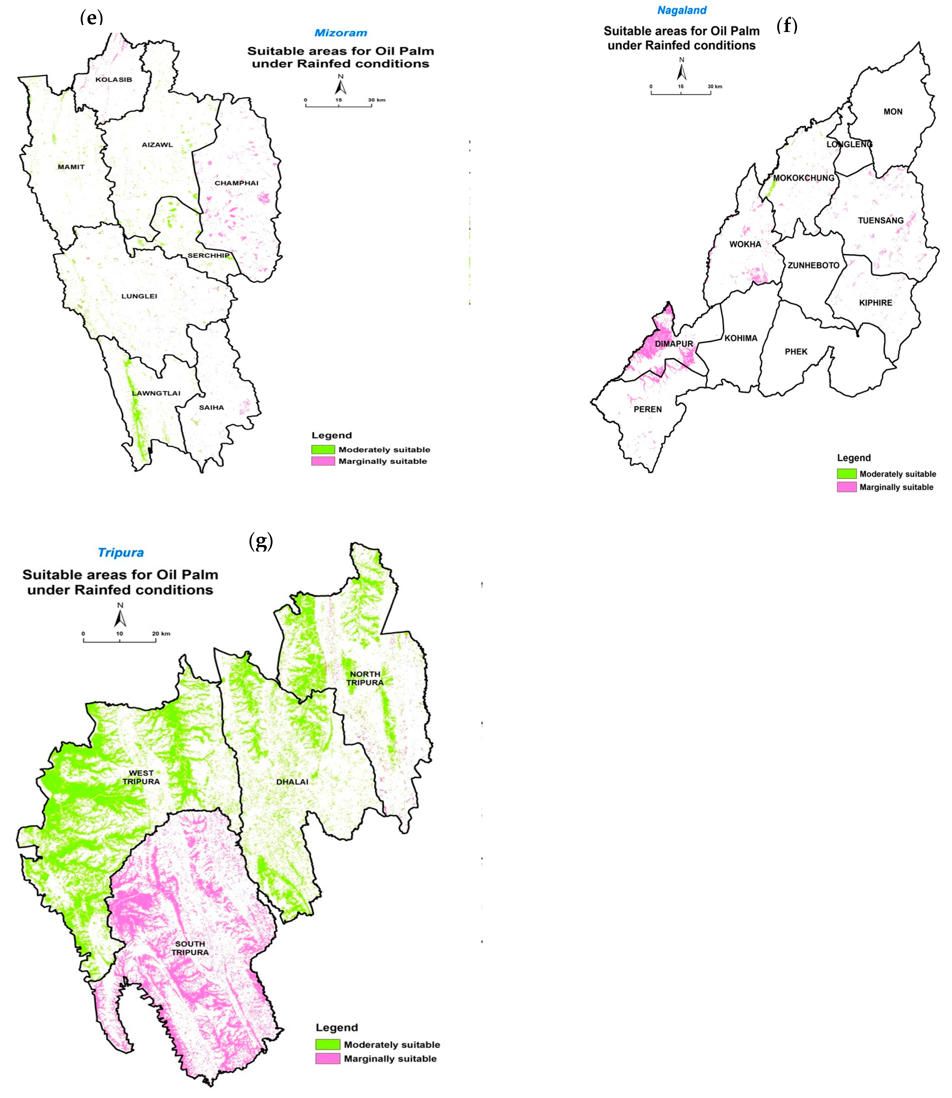
In Meghalaya, only 26,935 ha is under MoS situated in the East Khasi hills (Figure 5 and Figure 6d). A low minimum temperature and longer periods of continuous dry season are the two major limitations for OP suitability. In Mizoram, Lawngtlai, Mamit, Serchip and Aizawl are the areas with 15,470 ha of MoS area. In the remaining districts, the area is under marginal suitability only (Figure 5 and Figure 6e). In Nagaland, most of the suitable area for the rainfed cultivation of OP is under the MaS class (Figure 5 and Figure 6f). In Mizoram and Nagaland, the longer periods of continuous dry seasons, low minimum temperature, and high slope are the major constraints for OP suitability. In Tripura, MoS area is available in the West Tripura and Dhalai districts, and marginally suitable area is available in four districts, viz., South Tripura, North Tripura, Dhalai and West Tripura (Figure 5 and Figure 6g). In this state, the low minimum temperature and longer periods of continuous dry seasons are the major constraints. Out of seven NE states, Assam, Arunachal Pradesh, and Tripura, with a higher area under the MoS category, are better suited for OP cultivation under rainfed conditions.

3.3.2. Southern India

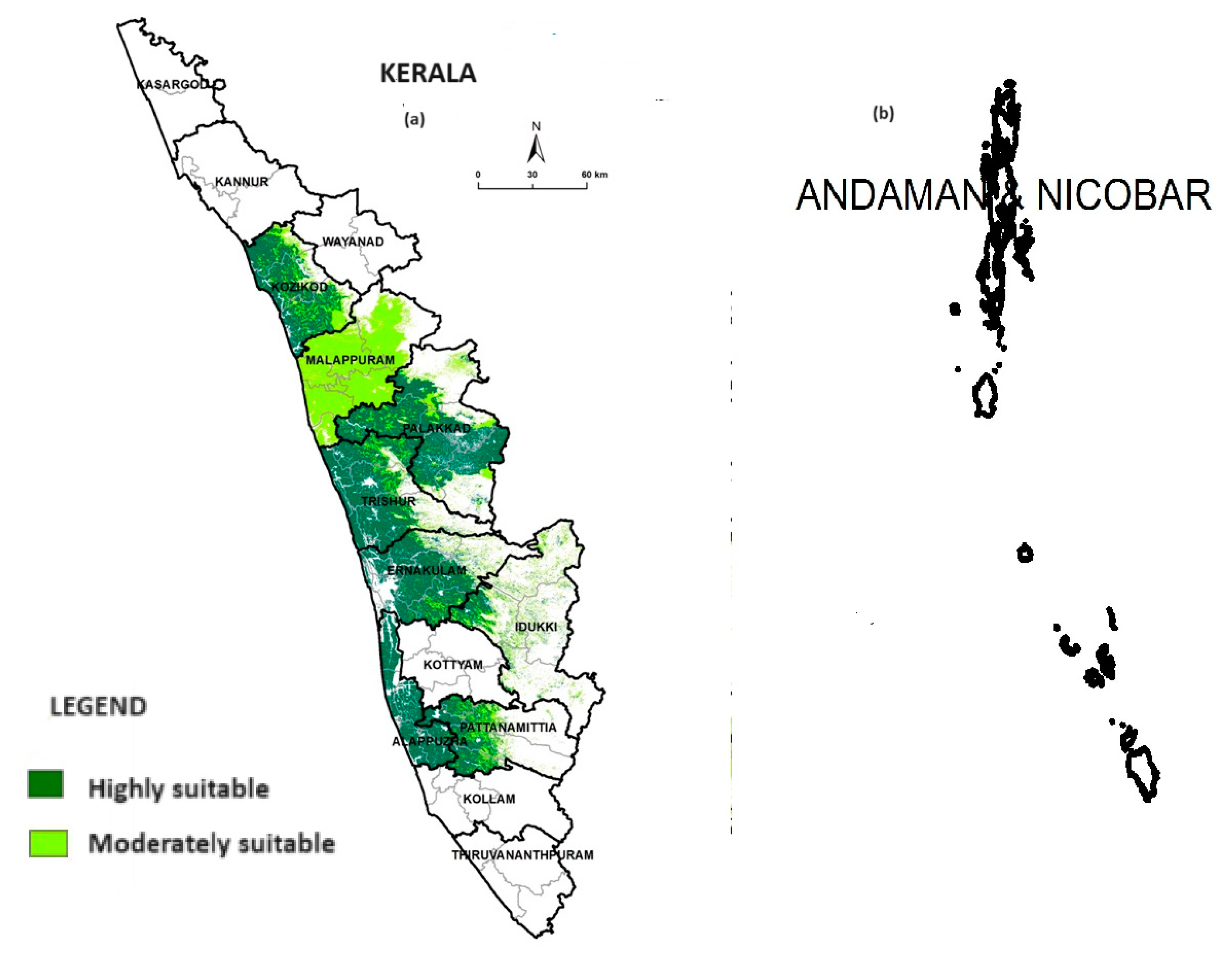
Among all the states suitable for the RF cultivation of OP in India, Kerala exhibits a larger area under the highly suitable class (Figure 5 and Figure 7a). After restricting suitable areas to selected LULC classes, Kerala has 1.57 Mha (40.51% of its TGA) of as suitable area for the RF cultivation of OP. Out of this, 56.6% is HS, 25% is MoS, and 18.3% is MaS. But, some of the areas (in Kasargod, Kozhikode, Palakkad, Idukki, Pattanmittia, Trishur and Ernakulam) were found to be in the moderately suitable category in Kerala, mainly because of the rainfall distribution (number of months with >100 mm) pattern and length of continuous dry period. In all these districts, the average annual rainfall is more than 2000 mm, but the number of months with >100 mm is only 6 to 7. In the Malappuram district of Kerala, most of the area is under MaS category because the average annual rainfall of 2952 mm is distributed in 7 months only (>100 mm/month). Except for the length of continuous dry periods in certain locations, all other parameters are in the optimal range for the majority of the locations of this state.
In Andaman and Nicobar Islands, 67,432 ha of area was found suitable for the RF cultivation of OP, and this entire area is under the highly suitable class (Figure 5 and Figure 7b). This is spread in Nicobar, North and Middle Andaman and South Andaman. Here, all the area is highly suitable and no constraints can be found for OP cultivation.

3.4. Model Validation

The developed model could not be validated vigorously, as existing oil palm plantations are not available in most of the states at present, including areas found potentially suitable for rainfed cultivation. In a few states, its cultivation started very recently (Nagaland, Arunachal Pradesh), and so FFB production has not yet started. However, some comparisons could be made with the average productivity levels of the Kerala and Mizoram states and also the yield levels of the different districts in Kerala.As per 2020 figures, FFB production in Kerala is 30,220 tonnes from 5919 ha, and in Mizoram, it is 4796 tonnes from 28,295 ha [6], which indicates better suitability in Kerala than Mizoram. Within Kerala, from the existing crops, higher per hectare yields are reported in the Pathanamthitta, Alappuzha, and Kottayam districts (7 to 25 tonnes per ha), where there is a large area suitable for OP, as this area is under the highly suitable category. In the Wayanad and Kollam districts, a highly suitable area is not available as per model estimates and the average yield levels are very low ranging between 1 and 6 tonnes per ha−1.
Further, the crop availability in the Pathanamthitta (Konni) and Ernakulam (Athirapalli) districts of Kerala has been compared (Figure 8a,b) with MCDA model estimates and found to be correct. Similarly, in the East Siang district of Arunachal Pradesh in north-eastern India, the existing plantation at Pasighat was found moderately suitable both at ground verification and as per model estimates (Figure 8c). The model results of our study confirm that highly suitable areas for cultivating OP under rainfed conditions are located at latitudes closer to the equator. Moving away from the equatorial region, the suitability is limited to areas in the moderately or marginally suitable classes, restricted to areas with higher altitudes where the annual rainfall is more than 2000 mm.

4. Discussion and Perspectives

Oil palm cultivation presents a promising solution to address the widening gap between the demand for and supply of edible oils in India. However, under irrigated conditions, the extensive water usage of approximately 10,725 m3 per hectare annually poses a significant challenge, leading to the depletion of water resources and unsustainable production levels in other crops. Rainfed oil palm cultivation is preferred as it minimizes pressure on water resources, particularly in regions with abundant rainfall distributed over 6 to 12 months.
Studies from different parts of the globe have identified key climatic parameters such as annual rainfall, temperature, relative humidity, and sunshine hours as critical for oil palm cultivation [46]. Adequate sunshine, rainfall of 2000–2500 mm annually, and optimal temperature ranges are essential for maximizing oil palm performance. However, variations in sunshine hours can impact fruit yield and oil extraction rates, highlighting the complexity of environmental factors influencing productivity. Adequate sunshine and solar radiation of 16–17 MJ m−2 day−1, annual rainfall of 2000–2500 mm, low vapor pressure deficit and temperatures of a mean maximum in the range of 29–33 °C and a mean minimum in the range 22–24 °C are needed for better performance [47]. Lim et al. [44] were of the opinion that (a) solar radiation—intensity and duration, (b) rainfall, (c) air temperature (mean, maximum, and minimum temperature), (d) relative humidity (RH), vapor pressure deficit (VPD), (e) evaporation, and (f) wind are more critical. Hartley [37] reported that annual sunshine hours are positively correlated with annual FFB yield about 28 months later. A higher number of sunshine hours increased the oil extraction rate (OER) about 18–20 months later [48]. In contrast, Prabowo and Foster [49] reported that sunshine had a negative correlation with OER due to poorer fruit/bunch and mesocarp/fruit ratios under North Sumatra conditions. In Uganda, Naidoo and Adam [50] conducted a study aiming to map suitable areas for oil palm cultivation using GIS-based Multi-Criteria Decision Analysis (MCDA) and identified 38.18%, 35.54%, 21.41%, and 4.87% of the land area as highly suitable, moderately suitable, marginally suitable, and unsuitable, respectively.
GIS-based MCDA is a robust technique in flawless decision making, as it analyzes multiple criteria at once. However, care needs to be exercised when selecting the criteria/parameters, assigning weights and classifying them with appropriate scores. In this study, initially, from our study of the literature, 12 parameters viz., rainfall, number of rainy days, mean temperature, RH, ground water level, soil pH, salinity, soil depth, surface texture, stoniness, slope, and drainage, were selected for assessing OP suitability. But, the ranking of these many parameters, allotting weights, and making sub-classes with suitable scores was found to be more complex. Further, the availability of reliable spatial data for those many parameters is another constraint. After a pilot study in one state (Andhra Pradesh), we conducted a wide range of consultations with domain experts and selected only the five most important parameters. Our experience professes that for assessing a smaller area, it is wise to have more parameters, but, when assessing a large geographical area, only a few, the most influential parameters, need to be selected by exercising more care and precision. Saadatian, Shahraki, and Shahabi [51] conducted a study on site suitability analysis for oil palm cultivation in South Sumatra Province, Indonesia, utilizing GIS and multi-criteria decision-making (MCDM) techniques. The integration of GIS and MCDM techniques proved to be effective in identifying suitable locations for oil palm cultivation, contributing to sustainable agricultural practices and economic development in Indonesia.
The key step in land suitability evaluation for any crop is the selection of criteria and assessing their weights [52]. Further, the reliability of evaluation results depends on the integrity of the database and the rationality of the evaluation methods [53]. The database used in the study was a standard high-precision resource. Holding a wide range of consultations with experts, conducting a thorough literature survey, and utilizing information from experimental results to select the criteria and estimate their weights proved right. This study is the first of its kind in India, evaluating suitable areas for OP cultivation by considering soil, topography and climatic parameters. From the model estimates, the majority of the Kerala state is bestowed with an area under the highly suitable category for rainfed oil palm cultivation. The steepness of the slope, low minimum temperature, and length of continuous dry season were found to be the most severe limiting factors for oil palm suitability in North-east India. In Indonesia, based on biophysical suitability assessment, about half of the area (51%) of Kalimantan was found highly to moderately suitable and nearly 37% of the area is unsuitable for OP production [54] due to the steepness of the slope and poor drainage. In Ghana, a major climatic factor limiting suitability for OP production is the annual water deficit, with the most suitable areas located in the rainforest and semi-deciduous forest zones with higher rainfall in southern Ghana [55], whereas, Ogunkunle [56] found that the major limitations for OP cultivation in Nigeria are soil fertility (K mole fraction, CEC) and particle size. In Uganda, through conducting a study on the geospatial assessment of land suitability for oil palm cultivation, Anjo Abraham and Ivan Bamweyana [57] identified 38.18%, 35.54%, 21.41%, and 4.87% of the land area as highly suitable, moderately suitable, marginally suitable, and unsuitable, respectively, from a suitability map obtained from a weighted linear combination.
The information generated in this study acts as a decision tool for policy makers in planning oil palm expansion in the country, and it is being used by the Indian government to allocate the oil palm crop to the most suitable areas for achieving the sustainable production of the crop in the country. Based on the information generated from this study, the government of India has launched the National Mission on Edible Oils—Oil palm, aimed at expanding oil palm cultivation in the country [1].
In this study, we used data at district level for rainfall, length of dry season, and minimum temperature. The soil depth scale was at 1:250,000 scale, and the slope was at 30 m scale from SRTM data. If spatial data sets of finer magnitude are used, the suitability map still provides accurate information. In future, with the availability of finer-scale data, the model could be further refined for better results. Further, through incorporating socio-economic factors like the willingness of the growers of oil palm, it is possible to generate better information to aid in designing an oil palm expansion program in the country.

5. Conclusions

Assessing land suitability for rainfed oil palm cultivation is vital for the development of India’s oil palm (OP) sector, particularly in the north-eastern states. Our study employed GIS-based Multi-Criteria Decision Analysis (MCDA) modeling, representing a pioneering effort in India, to evaluate OP production suitability. This approach integrated climatic, soil, and topographic factors at a country level, prioritizing highly influential parameters for accuracy and reliability. By identifying and weighting critical factors impacting oil palm cultivation, the MCDA model offers precise insights into suitable cultivation areas, optimizing resource allocation for sustainable agricultural development.
Our model identified a net suitable area of 4.25 million hectares across nine states, categorized into three suitability levels. Model validation aligned with existing OP growing locations, validating its reliability using five highly influential parameters: rainfall, minimum temperature, length of continuous dry period, soil depth, and slope. This decision support tool, in digital map form, guides policymakers in expanding OP cultivation to non-traditional locations, fostering socio-economic development. State-level GIS-based suitability maps aid in planning processing units and aid in ensuring sufficient raw material availability.
Identifying suitable areas for rainfed cultivation reduces pressure on water resources, which is crucial given OP’s high water requirements. Such assessments promote sustainable land utilization and can be adapted for other crops, contributing to holistic land management.

Author Contributions

K.M.: Conceptualization; Investigation; Methodology; Validation; Visualization; Writing–Original Draft. G.P.O.R.: Conceptualization; Methodology; Software; Validation; Writing–Review and Editing. K.S.: Resources; Investigation; Methodology; Writing–Review and Editing. S.S.R.: Conceptualization; Methodology; Writing–Review and Editing. S.K.B.: Data curation; Resources; Visualization, Writing–Review and Editing. N.K.: Methodology; Software Validation; R.K.M.: Writing–Review and Editing. All authors have read and agreed to the published version of the manuscript.

Funding

This research received no external funding.

Data Availability Statement

The raw data will be made available on request.

Conflicts of Interest

The authors declare no competing interests.

References

  1. NMEO-OP. 2021. Available online: https://nfsm.gov.in/Guidelines/NMEO-OPGUIEDELINES.pdf (accessed on 14 November 2022).
  2. Sujatha, M.; Sudhakara Babu, S.N.; Kumar, G.D.S. Strategies for enhancing production and productivity of annual oilseeds in India. In Proceedings of the Souvenir of International Conference on Vegetable Oils 2023, Hyderabad, India, 17–21 January 2023; pp. 1–11. [Google Scholar]
  3. Thakur, S. Moving towards self sufficiency in edible oils. In Proceedings of the Souvenir of International Conference on Vegetable Oils 2023, Hyderabad, India, 17–21 January 2023; pp. 12–17. [Google Scholar]
  4. Mathur, R.K.; Manorama, K.; Mary Rani, K.L.; Suresh, K. Technological interventions in oil palm—The way forward towards attaining self-sufficiency in edible oil production. In Proceedings of the Souvenir National Seminar—2020 on “Technological Innovations in Oil Seed Crops for Enhancing Productivity, Profitability and Nutritional Security”, Hyderabad, India, 7–8 February 2020; pp. 41–48. [Google Scholar]
  5. Prasad, M.V.; Suresh, K. Oil palm Research and Development Activities—Aspirations. In Proceedings of the Souvenir of International Conference on Vegetable Oils 2023, Hyderabad, India, 17–21 January 2023; pp. 38–41. [Google Scholar]
  6. Reddy, B.M.C.; Ray, S.S.; Arulraj, S.; Mathur, R.K. Reassessment Report. In Reassessment of Potential Areas for Oil Palm Cultivation in India and Revision of Targets Upwards; ICAR-IIOPR: Pedavegi, India, 2020; p. 132. ISBN 81-87561-59-9. [Google Scholar]
  7. Suresh, K.; Mathur, R.K.; Manorama, K. Yield gap analysis in oil palm. In Recent Advances in Oil Palm Production and Special Emphasis on Emergence of New Pest and Its Management; CRC Press: Boca Raton, FL, USA, 2019; pp. 111–114. ISBN 81-87561-58-0. [Google Scholar]
  8. Gurmessa, M.M.; Moisa, M.B.; Boru, L.H.; Deribew, K.T.; Roba, Z.R.; Negasa, J.J.; Tiye, F.S.; Gemeda, D.O. Geospatial assessment of potential land suitability for oil palm (Elaeis guineensis Jacq) cultivation in the western parts of Ethiopia. OCL 2023, 30, 23. [Google Scholar] [CrossRef]
  9. Singha, C.; Swain, K.C. Land suitability evaluation criteria for agricultural crop selection: A review. Agric. Rev. 2016, 37, 125–132. [Google Scholar] [CrossRef]
  10. Naidu, L.G.K.; Ramamurthy, V.; Challa, O.; Hegde, R.; Krishnan, P. Manual on Soil-Site Suitability Criteria for Major Crops; National Bureau of Soil Survey and Land Use Planning (ICAR): Nagpur, India, 2006; Available online: https://www.scirp.org/reference/referencespapers?referenceid=2757441 (accessed on 5 May 2024).
  11. Mendas, A.; Delali, A. Integration of multi-criteria decision analysis in GIS to develop land suitability for agriculture: Application to durum wheat cultivation in the region of Mleta in Algeria. Comput. Electron. Agric. 2012, 83, 117–126. [Google Scholar] [CrossRef]
  12. Saha, S.; Mondal, P. Estimation of the effectiveness of multi-criteria decision analysis and machine learning approaches for agricultural land capability in Gangarampur Subdivision, Eastern India. Artif. Intell. Geosci. 2022, 3, 179–191. [Google Scholar] [CrossRef]
  13. Zhang, J.; Su, Y.; Wu, J.; Liang, H. GIS based land suitability assessment for tobacco production using AHP and fuzzy set in Shandong province of China. Comput. Electron. Agric. 2015, 114, 202–211. [Google Scholar] [CrossRef]
  14. Benezoli, V.H.; Imbuzeiro, H.M.A.; Cuadra, S.V.; Colmanetti, M.A.A.; de Araújo, A.C.; Stiegler, C.; Motoike, S.Y. Modeling oil palm crop for Brazilian climate conditions. Agric. Syst. 2021, 190, 103130. [Google Scholar] [CrossRef]
  15. ElSheik, R.A.; Ahmad, N.; Shariff, A.; Balasundra, S.; Yahaya, S. An agricultural investment map based on geographic information system and multi-criteria method. J. Appl. Sci. 2010, 10, 1596–1602. [Google Scholar] [CrossRef]
  16. Baja, S.; Chapman, D.M.; Dragovich, D. A conceptual model for defining and assessing land management units using a fuzzy modeling approach in GIS environment. Environ. Manag. 2002, 29, 647–661. [Google Scholar] [CrossRef] [PubMed]
  17. Salem, M.Z.; Ageeb, G.W.; Rahim, I.S. Land suitability for agricultural of certain crops in Albostan area, Egypt. Res. J. Agric. Biol. Sci. 2008, 4, 485–499. [Google Scholar]
  18. Pan, G.; Pan, J. Research in crop land suitability analysis based on GIS. Comp. Technol. Agric. 2012, 365, 314–325. [Google Scholar] [CrossRef]
  19. Jiang, H.; Eastman, J.R. Application of fuzzy measures in multi-criteria evaluation in GIS. Int. J. Geogr. Inf. Sci. 2000, 14, 173–184. [Google Scholar] [CrossRef]
  20. Janssen, R.; Reitveld, P. Multi-criteria analysis and geographical information systems. An application to agricultural land use in the Netherlands. In Geographical Information Systems for Urban and Regional Planning; Scholten, H.J., Stillwell, J.C.H., Eds.; Kluwer Academic Publishers: Dordrecht, The Netherlands, 1990; pp. 129–139. [Google Scholar]
  21. Chen, H.-S.; Liu, G.-S.; Yang, Y.-F.; Ye, X.-F.; Shi, Z. Comprehensive evaluation of tobacco ecological suitability of Henan province based on GIS. Agric. Sci. China 2010, 9, 583–592. [Google Scholar] [CrossRef]
  22. Jayasinghe, S.L.; Kumar, L.; Sandamali, J. Assessment of Potential Land Suitability for Tea (Camellia sinensis (L.) O. Kuntze) in Sri Lanka Using a GIS-Based Multi-Criteria Approach. Agriculture 2019, 9, 148. [Google Scholar] [CrossRef]
  23. Ramamurthy, V.; Reddy, G.P.O.; Kumar, N. Assessment of land suitability for maize (Zea mays L) in semi-arid ecosystem of Southern India using integrated AHP and GIS approach. Comput. Electron. Agric. 2020, 179, 105806. [Google Scholar] [CrossRef]
  24. Tshabalala, T.; Ncube, B.; Moyo, H.P.; Abdel Rahman, E.M.; Mutanga, O.; Ndhlala, A.R. Predicting the spatial suitability distribution of Moringa oleifera cultivation using analytical hierarchical process modelling. S. Afr. J. Bot. 2020, 129, 161–168. [Google Scholar] [CrossRef]
  25. Malczewski, J. GIS-based land-use suitability analysis: A critical overview. Prog. Plan. 2004, 62, 3–65. [Google Scholar] [CrossRef]
  26. Reddy, G.P.O. Spatial data management, analysis, and modeling in GIS: Principles and applications. In Geospatial Technologies in Land Resources Mapping, Monitoring and Management; Reddy, G.P.O., Singh, S.K., Eds.; Geotechnologies and the Environment; Springer: Cham, Switzerland, 2018; Volume 21, pp. 127–142. [Google Scholar]
  27. Carr, M.K.V. The water relations and irrigation requirements of oil palm (Elaeis guineensis): A review, Experiment Agriculture. Exp. Agric. 2011, 47, 629. [Google Scholar] [CrossRef]
  28. Lim, K.H.; Goh, K.J.; Kee, K.K.; Henson, I.E. Climatic Requirements of Oil Palm. 1957. Available online: https://www.researchgate.net/publication/308054675_Climatic_requirements_of_oil_palm (accessed on 30 January 2020).
  29. Boonyanuhap, J.; Det, W.; Sakurai, K. GIS based land suitability assessment for (MUSACABB group) plantation. J. Appl. Hort. 2004, 6, 3–10. [Google Scholar] [CrossRef]
  30. FAO. A Framework for Land Evaluation; FAO: Rome, Italy, 1976; Available online: https://www2.alterra.wur.nl/Internet/webdocs/ilri-publicaties/publicaties/Pub22/pub22-h1.pdf (accessed on 5 May 2024).
  31. Djaenudin, D.; Marwan, H.; Subagyo, H.; Hichyat, A. Guidelines of Land Evaluation for Agricultural Crops; Soil Research and Agro-Climate Center: Bogor, Indonesia, 2003. [Google Scholar]
  32. ESRI. ArcGIS Ver 10.3; Environmental Systems Research Institute: Redlands, CA, USA, 2015. [Google Scholar]
  33. Pirker, J.; Mosnier, A.; Kraxner, F.; Havlík, P.; Obersteiner, M. What are the limits to oil palm expansion? Glob. Environ. Change 2016, 40, 73–81. [Google Scholar] [CrossRef]
  34. Paramananthan, S. Soil requirements of oil palm for high yields. In Managing Oil Palm for High Yields: Agronomic Principles; Goh, K.J., Ed.; Malaysian Society of Soil Science and Param Agricultural Surveys: Kaulalumpur, Malaysia, 2000; pp. 18–38. [Google Scholar]
  35. Reddy, V.M.; Suresh, K.; Sarma, K.N.; Sivasankara Kumar, K.M.; Bhanusri, A.; Ramakrishna, P. Root biomass distribution in relation to its moisture pattern under different irrigation methods in oil palm. In Proceedings of the 15th Plantation Crops Symposium (Placrosym XV), Mysore, India, 10–13 December 2002; pp. 344–347. [Google Scholar]
  36. Corley, R.H.V.; Tinker, P.B. (Eds.) The Oil Palm, 5th ed.; John Wiley & Sons: Hoboken, NJ, USA, 2016; ISBN 978-1-405-18939-2. [Google Scholar]
  37. Hartley, C.W.S. The Oil Palm (Elaeis guineensis Jacq.); Longman Group Limited: London, UK, 1988. [Google Scholar]
  38. Suresh, K.; Reddy, V.M.; Sarma, K.N.; Bhanusri, A.; Sivasankara Kumar, K.M. Quantification of root biomass in oil palm grown under basin irrigation. Int. J. Oil Palm 2003, 2, 39–41. [Google Scholar]
  39. Manorama, K.; Chandran, K.P.; Mathur, R.K.; Suresh, K.; Behera, S.K. Efficient plot size for oil palm (Elaeis guineensis Jacq.) field experiments. J. Oil Seeds Res. 2019, 36, 250–257. Available online: https://epubs.icar.org.in/index.php/JOR/article/view/136708 (accessed on 5 May 2024).
  40. Goh, K.J.; Chew, P.S.; Teo, C.B. Maximising and maintaining oil palm yields on commercial scale in Malaysia. In ISP Planters’ Conference on Managing Oil Palms 41 for Enhanced Profitability; Chee, K.H., Ed.; ISP: Kuala Lumpur, Malaysia, 1994; pp. 121–141. [Google Scholar]
  41. Fairhurst, T.H.; Mclaughlin, D. Sustainable Oil Palm Development on Degraded Land in Kalimantan; World Wildlife Fund: Washington, DC, USA, 2009; Available online: https://assets.worldwildlife.org/publications/355/files/original/Sustainable_Oil_Palm_Development_on_Degraded_Land_in_Kalimantan__Indonesia.pdf?1345735065 (accessed on 5 May 2024).
  42. Paramananthan, S. Managing marginal soils for sustainable growth of oil palms in the tropics. J. Oil Palm Environ. 2013, 4, 1–16. [Google Scholar] [CrossRef]
  43. Olivin, J. Étude pour la localisation d’un bloc industriel de palmiers à huile. Oléagineux 1968, 23, 499–504. [Google Scholar]
  44. Lim, K.H.; Goh, K.J.; Kee, K.K.; Henson, I.E. Climatic requirements of oil palm. In Agronomic Principles and Practices of Oil Palm Cultivation; Goh, K.-J., Chiu, S.-B., Paramananthan, S., Eds.; Wiley: Hoboken, NJ, USA, 2015; pp. 1–48. ISBN 978-983-43384-1-1. [Google Scholar]
  45. Kee, K.K. Regional rainfall pattern and climatic limitations for plantation crops in Peninsular Malaysia. Planter 1995, 71, 67–78. [Google Scholar]
  46. Suresh, K.; Mathur, R.K.; Manorama, K. History of oil palm in Indian edible oil scenario—R & D. In Recent Advances in Oil Palm Production and Special Emphasis on Emergence of New Pest and Its Management; CRC Press: Boca Raton, FL, USA, 2019; pp. 1–9. ISBN 81-87561-58-0. [Google Scholar]
  47. Uning, R.; Latif, M.T.; Othman, M.; Juneng, L.; Mohd Hanif, N.; Nadzir, M.S.M.; Abdul Maulud, K.N.; Jaafar, W.S.W.M.; Said, N.F.S.; Ahamad, F. A Review of Southeast Asian Oil Palm and Its CO2 Fluxes. Sustainability 2020, 12, 5077. [Google Scholar] [CrossRef]
  48. Chow, C.S.; Chang, K.C. Effects of sunshine hours on oil extraction rate with special reference to the haze in recent years. In National Seminar on Opportunities for Maximising Production through Better OER and Offshore Investment in Oil Palm; PORIM: Bangi, Selangor, Malaysia, 1999; pp. 244–253. [Google Scholar]
  49. Prabowo, N.E.; Foster, H.L. Variation in oil and kernel extraction rates of oil palms in North Sumatra due to nutritional and climatic factors. In Proceedings of the 1998 International Oil Palm Conference. Commodity of the Past, Today, and the Future, Bali, Indonesia, 23–25 September 1998; pp. 275–286. [Google Scholar]
  50. Naidoo, K.; Adam, S. Mapping suitability areas for oil palm cultivation using GIS-based multi-criteria decision analysis. S. Afr. J. Geomat. 2016, 5, 315–328. [Google Scholar]
  51. Saadatian, O.; Shahraki, S.; Shahabi, H. Site suitability analysis for oil palm cultivation using GIS and multi-criteria decision-making techniques: A case study in South Sumatra Province, Indonesia. Geocarto Int. 2017, 32, 355–373. [Google Scholar]
  52. Duc, T.T. Using GIS and AHP technique for land-use suitability analysis. In Proceedings of the International Symposium on Geoinformatics for Spatial Infrastructure Development in Earth and Allied Sciences, Ho Chi Minh City, Vietnam, 9–11 November 2006; pp. 1–6. Available online: https://citeseerx.ist.psu.edu/viewdoc/download?doi=10.1.1.468.4502&rep=rep1&type=pdf (accessed on 5 May 2024).
  53. Shi, Z.; Guan, Y.L.; Wang, Y.G.; Huang, M.X.; Gong, J.Q.; Wang, L.H. Adjustment of citrus planting structure supported by the integrated remote sensing and GIS. Econ. Geog. 2002, 22, 727–730. (In Chinese) [Google Scholar]
  54. Mantel, S.; Wosten, H.; Verhagen, J. Biophysical Land Suitability for Oil Palm in Kalimantan, Indonesia; Wiley: Hoboken, NJ, USA, 2007. [Google Scholar]
  55. Rhebergen, T.; Fairhurst, T.; Zingore, S.; Fisher, M.; Oberthür, T.; Whitbread, A. Climate, soil and land-use based land suitability evaluation for oil palm production in Ghana. Eur. J. Agron. 2016, 81, 1–14. [Google Scholar] [CrossRef]
  56. Ogunkunle, A.O. Soil in land suitability evaluation: An example with oil palm in Nigeria. Soil Use Manag. 1993, 9, 35–39. [Google Scholar] [CrossRef]
  57. Abraham, A.; Bamweyana, I. Geospatial Assessment of Land Suitability for Oil Palm (Elaeis guineensis Jacq.) Growing in Northern Uganda. S. Afr. J. Geomat. 2022, 11, 310–324. [Google Scholar] [CrossRef]
Figure 1. Location map of study area.
Agriculture 14 00986 g001
Figure 2. Input thematic maps of parameters for oil palm suitability assessment (a) Rainfall; (b) minimum temperature; (c) length of continuous dry period (days); (d) soil depth (cm); (e) slope (%), and (f) selected LULC classes.
Agriculture 14 00986 g002
Figure 3. Methodology adopted in modeling oil palm suitability under rainfed conditions.
Agriculture 14 00986 g003
Figure 4. Map of India for the suitability of oil palm cultivation under rainfed conditions.
Agriculture 14 00986 g004
Figure 5. State-wise suitable areas (ha) for rainfed OP cultivation in India (after integrating considered LULC classes).Biophysically suitable areas estimated for OP cultivation were restricted to only 8 LULC classes.
Agriculture 14 00986 g005
Figure 6. Oil palm suitability under rainfed conditions in (a) Arunachal Pradesh, (b) Assam, (c) Manipur, (d) Meghalaya, (e) Mizoram, (f) Nagaland and (g) Tripura.
Agriculture 14 00986 g006aAgriculture 14 00986 g006b
Figure 7. Oil palm suitability under rainfed conditions in (a) Kerala and (b) Andaman andNicobar Islands.
Agriculture 14 00986 g007
Figure 8. Validation sites of oil palm suitability with field data at (a) Konni village of Pathanamthitta district, (b) Athirapalli village of Ernakulam district and (c) Pasighat at East Siang distrct of Arunachal Pradesh state.
Agriculture 14 00986 g008
Table 1. Parameters selected with weights and sub-classes.
Critical Parameter and RankPer Cent Weight Assigned (%)Sub-Classes
Highly SuitableModerately SuitableMarginally SuitableNot Suitable
1. Mean annual rainfall45>1800 mm in 8 or more months>1800 mm in 7 months>1500–1800 mm in >7 months<1500 mm in <7 months (Restricted)
2. Months with <15° C minimum temperature20<15 °C for <1 month<15 °C for 1–2 months<15 °C for 2–4 months<15 °C for >4 months
3. Slope (%)150–12
(0–6°)
12–23
(6–12°)
23–38
(12–20°)
>38 (20°)
(Restricted)
4. Length of continuous dry period10<30 days31–60 days61–90 days>90 days
5. Depth of soil10>100 cm76–100 cm50–75 cm<50 cm
Table 2. Input parameters, their theme weights, and class scores in GIS-based MCDA in modeling land suitability for oil palm cultivation.
Input Parameters% InfluenceClassScale Value
Annual rainfall (normal)4519
27
35
4Restricted
NodataNodata
Months with <15 °C Minimum temperature2019
27
34
4Restricted
NodataNodata
Slope1519
27
34
4Restricted
NodataNodata
Length of continuous dry period (number of days)1019
24
32
4Restricted
NodataNodata
Soil depth1019
27
33
4Restricted
5Restricted
NodataNodata
Disclaimer/Publisher’s Note: The statements, opinions and data contained in all publications are solely those of the individual author(s) and contributor(s) and not of MDPI and/or the editor(s). MDPI and/or the editor(s) disclaim responsibility for any injury to people or property resulting from any ideas, methods, instructions or products referred to in the content.