Article

Social-Ecological Spatial Analysis of Agroforestry in the European Union with a Focus on Mediterranean Countries

by
Dimitrios Fotakis
*,
Ilias Karmiris
,
Diogenis A. Kiziridis
,
Christos Astaras
and
Thomas G. Papachristou
Forest Research Institute, Hellenic Agricultural Organization DIMITRA, 57006 Thessaloniki, Greece
*
Author to whom correspondence should be addressed.
Agriculture 2024, 14(8), 1222; https://doi.org/10.3390/agriculture14081222
Submission received: 17 June 2024 / Revised: 17 July 2024 / Accepted: 17 July 2024 / Published: 25 July 2024
(This article belongs to the Section Agricultural Economics, Policies and Rural Management)

Abstract

:
Agroforestry has a long history of evolution in Europe and has been especially selected under the unfavorable socioeconomic and environmental conditions of the Mediterranean region. The recent changes in social-ecological conditions have increased the interest in the contribution of agroforestry to the mitigation of forthcoming challenges. Thus, the present study aimed to analyze the socioeconomic and ecological suitability of agricultural lands for preserving, restoring, and establishing agroforestry practices in Europe. We classified different agroforestry systems based on the LUCAS database, finding that most agroforestry in Europe is in areas associated with older human populations of varying densities and employment levels at lower altitudes, gentler slopes, moderate annual mean temperature and precipitation, and in medium textured soils with limited organic carbon content. Focusing on the prevalent agroforestry system of silvopasture, the majority of which is found in three Mediterranean ecoregions of mainly sclerophyllous forests, the most important factors for the occurrence of this system were subsoil available water content (Aegean), land cover (Adriatic), and topsoil available water content (Iberian). The suitable area for silvopasture according to MaxEnt was 32%, 30%, and 22% of the Aegean, Adriatic, and Iberian ecoregion’s area, respectively. Such mapping of agroforestry suitability can help policymakers to undertake adaptive management for the implementation of agroforestry-based solutions to address ecosystem restoration, food insecurity, and rapid environmental changes and threats.

1. Introduction

Agroforestry is a land-use management system that combines the production of trees with crops and/or livestock [1]. It involves the integration of trees and shrubs into farming and animal husbandry systems to create more diverse and productive landscapes. Agroforestry can provide a range of ecosystem services, including soil conservation, carbon sequestration, and habitat provision while also increasing agricultural productivity and the resilience of farming systems to environmental and economic shocks [2]. Some common examples of agroforestry practices include: (i) alley cropping, in which trees or shrubs are planted in rows and intercropped with annual or perennial crops; (ii) silvopasture, in which trees are integrated into pastureland for livestock grazing; and (iii) forest farming, in which specialty non-timber forest products are produced under the canopy of a forest. Agroforestry has the potential to contribute to the sustainable development of rural landscapes and communities around the world [1,2].
Agroforestry is an age-old tradition in some European Union (EU) countries and still has a strong presence today, as it is gaining popularity due to its ecological and economic advantages. The Common Agricultural Policy (CAP) of the EU recognizes and supports agroforestry, providing direct payments per hectare of land and support for establishing and maintaining agroforestry systems under the rural development strand. Specifically, a support of EUR 3.2 billion (approximately 1%) of the total EUR 307 billion of the latest CAP is planned to be invested in the forestry sector during the 2023–2027 period [3]. According to evaluation studies of previous CAP periods, the funding from the forestry sector, specifically targeting agroforestry, has increased the area established in agroforestry systems from 2904 ha (2007–2014) to 72,529 ha (2007–2014) [4], with a plan to reach 622,000 ha in the 2023–2027 period [3]. Innovation and research in agroforestry may also receive support. The European Parliament has acknowledged the advantages of agroforestry in several resolutions and urged for improved assistance for various sustainable production methods, including agroforestry [5].
The extent of agroforestry in the EU has been previously estimated by analyzing land use and land cover from the database LUCAS (Land Use/Cover Area Survey) [6]. According to these recent estimates, the land attributed to agroforestry occupies 8.8% of the used agricultural area in the EU. From this percentage, a vast proportion is attributed to livestock agroforestry, which primarily occurs in European countries within the Mediterranean region. With these estimates about agroforestry’s extent in the EU, what is missing in the literature is the connection between agroforestry occurrence and social-ecological factors related to agroforestry at the European level. The aim of the present study was, hence, to identify the social-ecological conditions that have both in the past and the present been related to this land-use practice to identify parameters that can render agricultural land suitable for agroforestry in the future [7]. Consequently, we hypothesized that the variability of suitability for agroforestry systems across EU biogeographical regions is influenced by factors such as climate, soil, topography, ecology, and socioeconomic conditions.
Identifying suitable land for agroforestry is important for ensuring that agroforestry practices are implemented in areas where they are most likely to be productive, providing maximum benefits and, therefore, contributing towards meeting policy objectives, such as to: (i) increase the yield of crops; (ii) improve the productivity of small-holder farmers; (iii) add value to the agricultural value chain; (iv) guide subsidies in a targeted manner; and (v) promote sustainable agriculture for ensuring long-run livelihoods and for protecting the provision of environmental services, which tend to not be reflected in the price of agricultural commodities. These objectives have become increasingly important due to the rapid environmental and socioeconomic changes of the past few decades [8,9,10]. Socioeconomic changes are also reflected in the land abandonment that has been occurring over the last decades, especially in the Mediterranean region [11,12]. As a consequence, agroforestry is expected to be one of the land uses with the highest vulnerability to environmental and socioeconomic changes, as grasslands, silvopastoral, and agricultural areas are left to the rewilding that follows land abandonment [13].
To build a framework for agroforestry development, land evaluation is necessary, considering climate, soil, topography, environmental constraints, disturbances, socioeconomic needs, and anthropogenic pressure on available lands [14]. These factors form a complex biophysical matrix of necessary conditions and limitations that determine the development of specific agroforestry systems on a piece of land, as noted by Mbow et al. [15]. Identifying these factors for agroforestry can be valuable in planning effective nature-based solutions for climate change mitigation and adaptation [16]. Since agroforestry policy needs to be adapted to the local variability of social and ecological drivers, a promising approach would be, at first, to study their contribution to a wider extent, and then to focus on specific regions of interest [17], as we herein did with our spatial analyses.
For the EU countries, spatial statistical analysis to a wider extent can be performed using GIS, based on relevant drivers, including biogeographic, biophysical, bioclimatic, topographic, soil, and socioeconomic factors. GIS tools have proven to be valuable for sustainable land planning and management [18,19,20]. They have been effectively utilized to evaluate land suitability for agriculture [21] and agroforestry [22]. The findings obtained from the wider extent analysis can serve as a basis for focusing the modeling on the spatial relationships regarding an agroforestry system of interest and in specific ecological regions (ecoregions). For this focused analysis, an appropriate tool is MaxEnt, an ecological niche model based on Maximum Entropy [23]. MaxEnt can improve model fitness performance through iterative calculations that utilize specific geographic locations of target “species” and their environmental conditions. This enables the determination of habitat suitability or the probability of species occurrence [24]. Although initially built for biological species, studies have shown that MaxEnt can also be used for land-suitability analysis [25,26], which is an approach we took to model agroforestry suitability at the regional scale.
The objective of the present study was to enhance the empirical understanding of the linkages between social-ecological factors and agroforestry land use through the utilization of statistical analyses on European data. For classifying the different agroforestry systems, we used the harmonized LUCAS database. We performed spatial statistical analyses at two spatial extents. First, we examined the relationship of the factors with the presence of various agroforestry systems to a wider extent across the EU countries. Second, based on the results from a wider extent, we focused on the prevalent European agroforestry system, i.e., the silvopastoral. This system occurs in specific ecoregions of the Mediterranean bioregion, a region that has the highest occurrence of agroforestry systems across Europe. Mapping the suitability of agroforestry at the level of ecoregions would allow policymakers to plan land use that is specific to each location. Consequently, this could aid the expansion and implementation of agroforestry-based models for addressing ecosystem restoration and food insecurity.

2. Materials and Methods

2.1. Study Area

The research area was defined as the beneficiary countries of the European Union’s CAP policy. These 27 countries, called EU27 hereafter, are the following: Austria, Belgium, Bulgaria, Croatia, Cyprus, Czech Republic, Denmark, Estonia, Finland, France, Germany, Greece, Hungary, Ireland, Italy, Latvia, Lithuania, Luxembourg, Malta, Netherlands, Poland, Portugal, Romania, Slovakia, Slovenia, Spain, and Sweden.
Further analysis was conducted in three ecoregions of the Mediterranean biogeographical region, namely: (i) Aegean and West Turkey sclerophyllous and mixed forests; (ii) Tyrrhenian–Adriatic sclerophyllous and mixed forests; and (iii) Iberian sclerophyllous and semi-deciduous forests.

2.2. LUCAS Harmonized Database

Our in situ observations were derived from the harmonized LUCAS database for field surveys. Data for LUCAS have been sampled in two phases. First, photo-interpreted points on a regular grid of points 2 km apart were categorized into seven broad classes of land cover, such as cereals or woodland. Second, a subset of the first survey’s points that were more representative were selected and further sampled by field surveyors for assigning them to more detailed classes of land cover, such as barley (coded as B13) and pine-dominated woodland (C22). The LUCAS database hence employs a bi-layer classification system that can detect the simultaneous presence of trees (coded as the LC1 primary layer) and crops or grass (coded as the LC2 secondary layer). As a result, it becomes possible to identify agroforestry areas where trees and crops are grown on the same land. A total of 1,351,293 observations at 651,780 unique locations were collected during five LUCAS surveys and were harmonized into one database. Although the surveys took place from 2006 to 2018, and hence are not very recent, we used the LUCAS database because it is harmonized, and it is the most comprehensive in situ dataset on land cover and land use in the EU [27]. LUCAS is a survey across all EU member states, which is used to gather information on land cover and land use, organized by the Directorate General responsible for agriculture and with the technical support of the European Commission’s Joint Research Centre (JRC) [28].

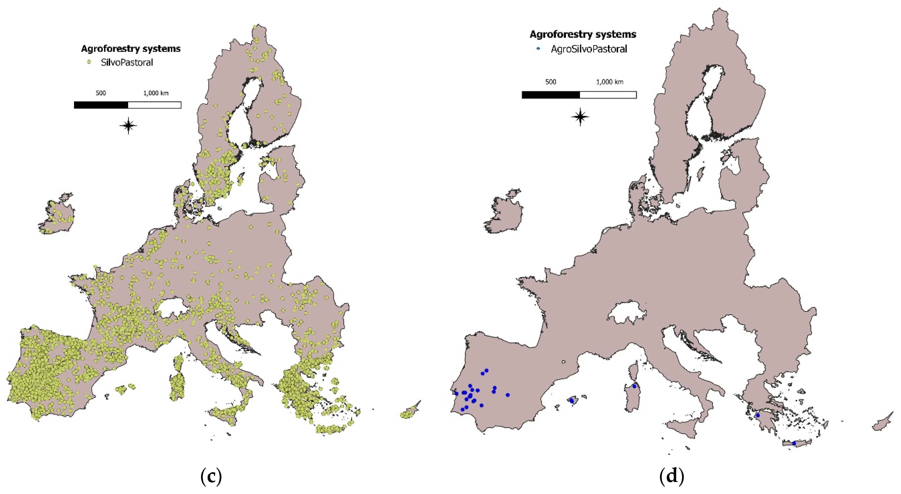
2.3. Agroforestry Systems

To pinpoint areas where livestock are grazing on cultivated land, we utilized the “signs of grazing” variable, which is included in the LUCAS database. By using this approach, similar to Herder et al. [6], we can identify four primary agroforestry systems present in the 27 EU countries that constitute the study area: AgroPastoral, AgroSilvo, AgroSilvoPastoral, and SilvoPastoral.
Sorted by increasing order of their potential to mitigate climatic variability and change [29,30], the definitions of the agroforestry systems we studied are the following (LUCAS subclasses are described in Table S1):
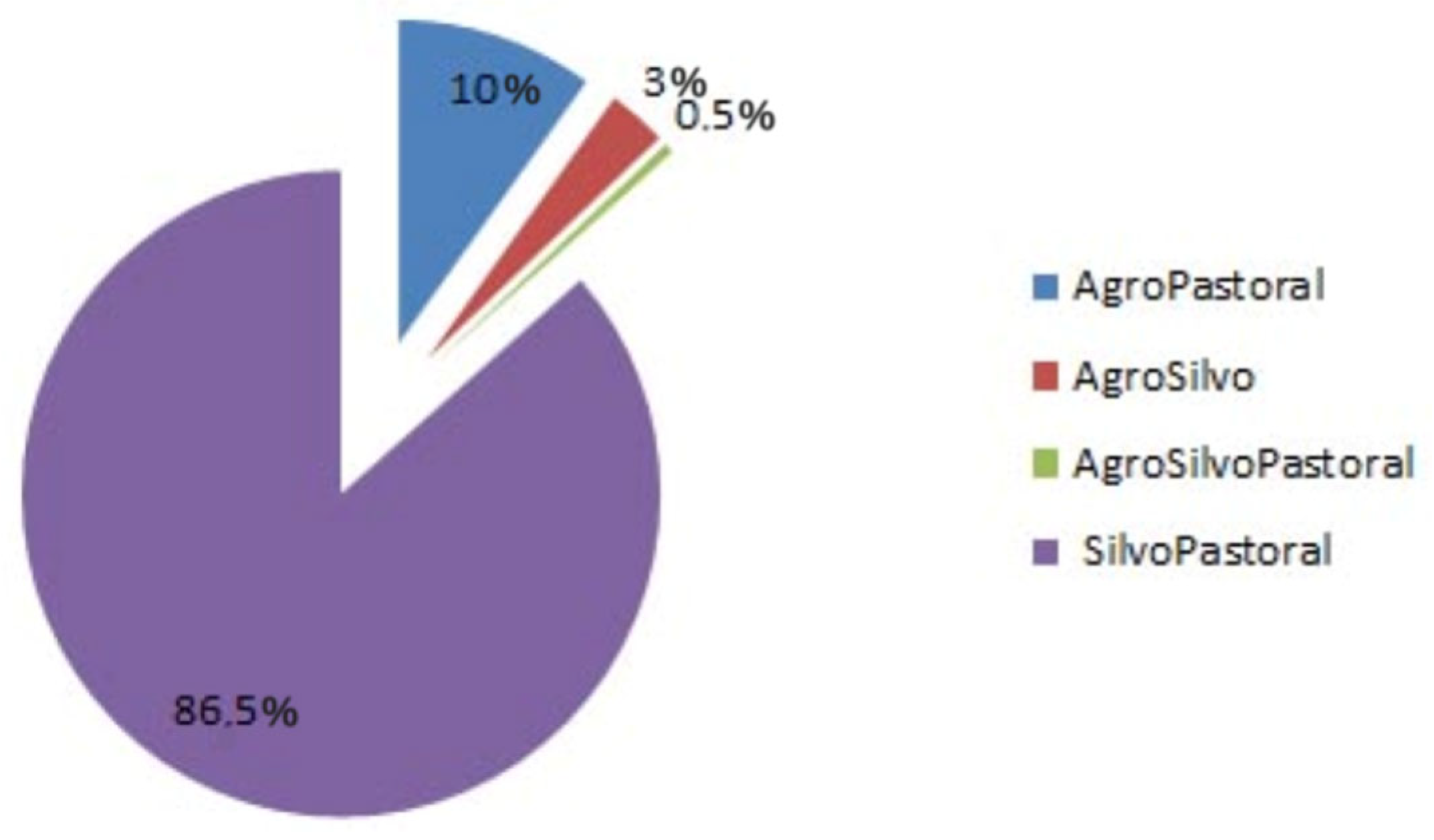
  • AgroPastoral systems are identified as systems combining crops with signs of grazing. These systems include the subclasses B11–B54 of cropland (i.e., all the subclasses that any crop is planted and cultivated, except trees) with signs of grazing.
  • AgroSilvo systems result from the combination of crops with cultivated trees. For this purpose, we combine the subclasses B71–B84 of cropland (i.e., all subclasses with cultivated trees), C10–C33 of woodland (i.e., all subclasses of woodland with a canopy covering ≥ 10% of the surface), and D10 of shrubland (i.e., areas dominated by ≥10% of their surface by shrubs, low woody species, and tree canopy < 10%) with the subclasses B11–B54 of cropland.
  • AgroSilvoPastoral systems are defined as systems combining crops, cultivated trees, and signs of grazing. In essence, these systems emerged from the combination of all the areas included in the AgroSilvo system with signs of grazing, i.e., a combination of grazed woodland and cropland.
  • SilvoPastoral systems include all the systems of the AgroSilvoPastoral system, but without the “Agro” component, i.e., systems where only tree cultivation and signs of grazing occurred at the same time and place.
In total, 5100 sites identified as agroforestry were overlaid (Figure 1), and their attribute data were integrated with spatial information of 19 layers of all the factors and subsequent variables used, as detailed below.

2.4. Factors and Variables Selected and Ranked

We focused on six factors, including the ecoregion type, Corine land use, bio-climate, topography, soil, and socioeconomy. These factors were analyzed as 19 variables to identify possible patterns of agroforestry systems. All data sources and variables used are listed in Table 1.

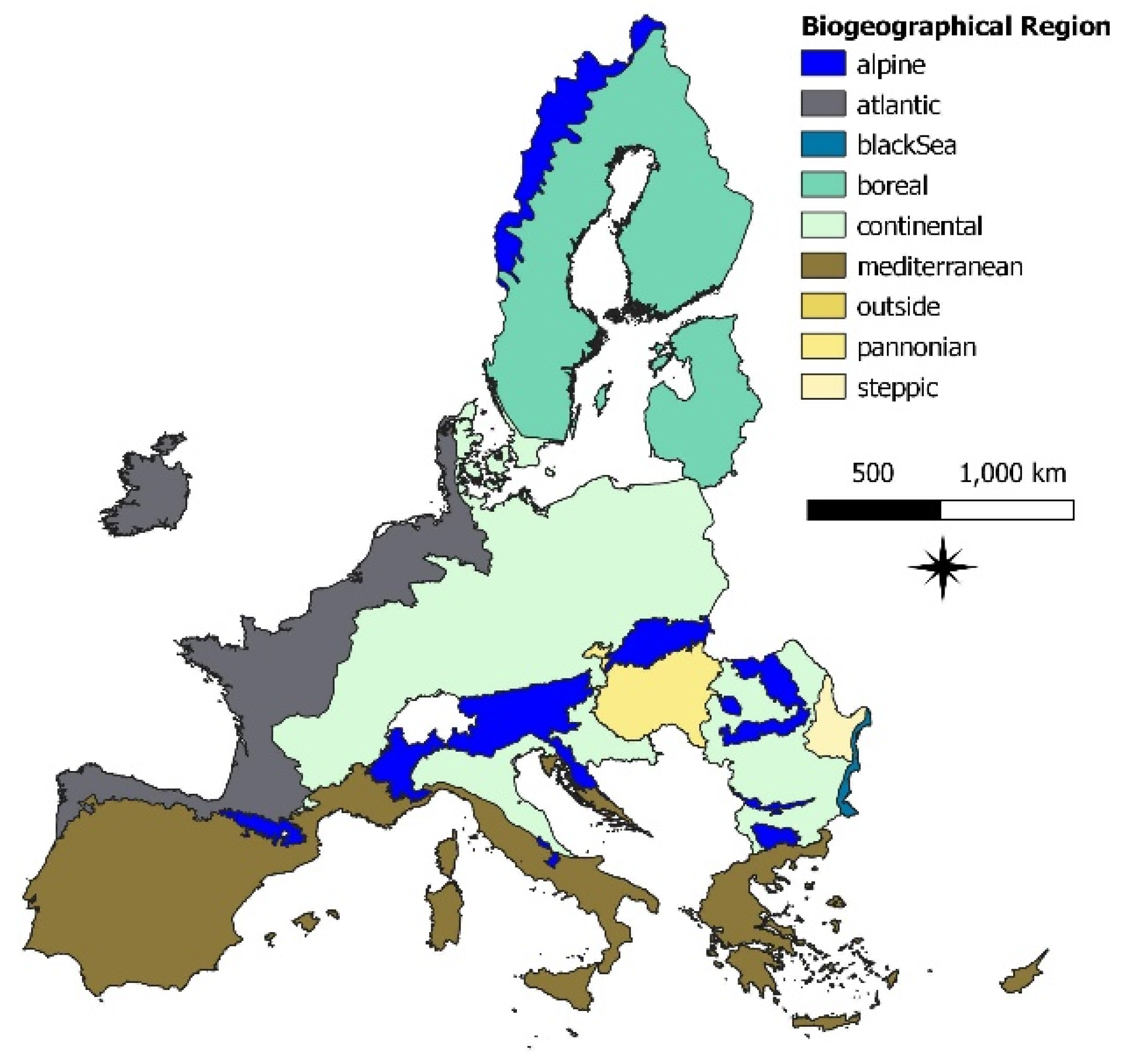
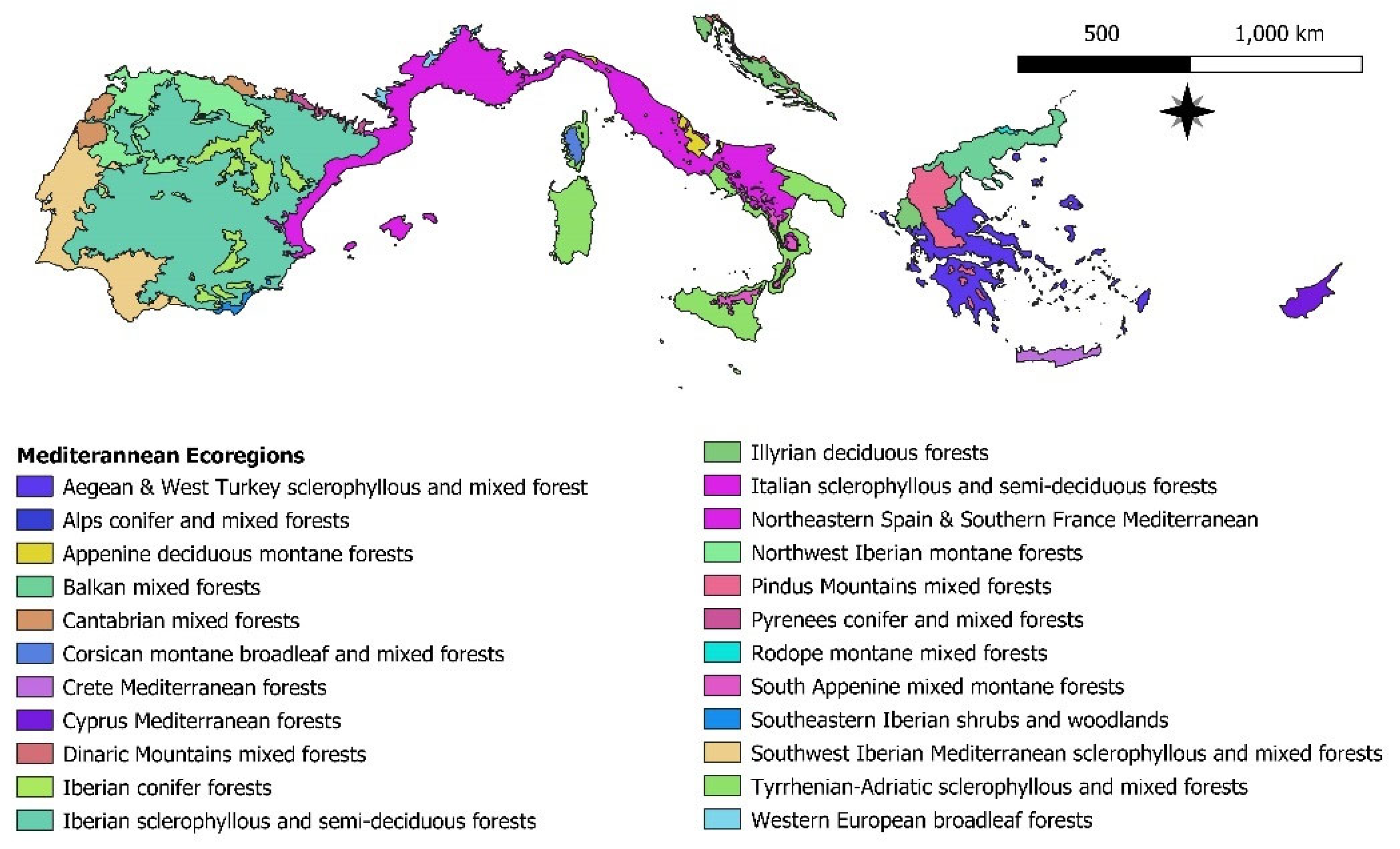
2.4.1. European Biogeographical and Ecological Regions

For the spatial statistical analysis in EU countries, we used a European-wide map of biogeographical regions that is independent of political boundaries, obtained from the European Environmental Agency (EEA) [31]. The map has been produced by combining biogeographical boundaries obtained from both the EU Member States and the Emerald Network countries (Figure 2).
There are 20 different ecoregions in the Mediterranean biogeographical region (Figure 3). Three of them, with the most observed SilvoPastoral sites, were chosen for further analysis, namely the ecoregions of Aegean and West Turkey sclerophyllous and mixed forests, Tyrrhenian–Adriatic sclerophyllous and mixed forests, and Iberian sclerophyllous and semi-deciduous forests. We specified our study to ecoregions to exhibit the boundaries of areas with similar ecological conditions, where comparisons and evaluations of diverse forms of ecosystems hold significance since they play a crucial role in determining the suitability of an area for agroforestry practices. We used the Digital Map of European Ecological Regions (DMEER) issued by the EEA [32].

2.4.2. Biophysical Factor

CORINE land cover is a European land cover database created to provide a standardized and harmonized view of land cover across the EU. We used the latest version, published in 2018, which provides information on the type and extent of land use and land cover in Europe, based on satellite imagery from 2016–2018. It includes 44 classes of land cover, ranging from urban areas to agricultural land, forests, and wetlands. Input data for CORINE land cover must be of at least 25 ha cover if they concern a polygon, and of at least 100 m length if they concern a vector element. For our analysis, we used the five main categories as input in the MaxEnt software for the spatial relationships modeling, namely: artificial surfaces, agricultural areas, forest and semi-natural areas, wetlands, and water bodies.

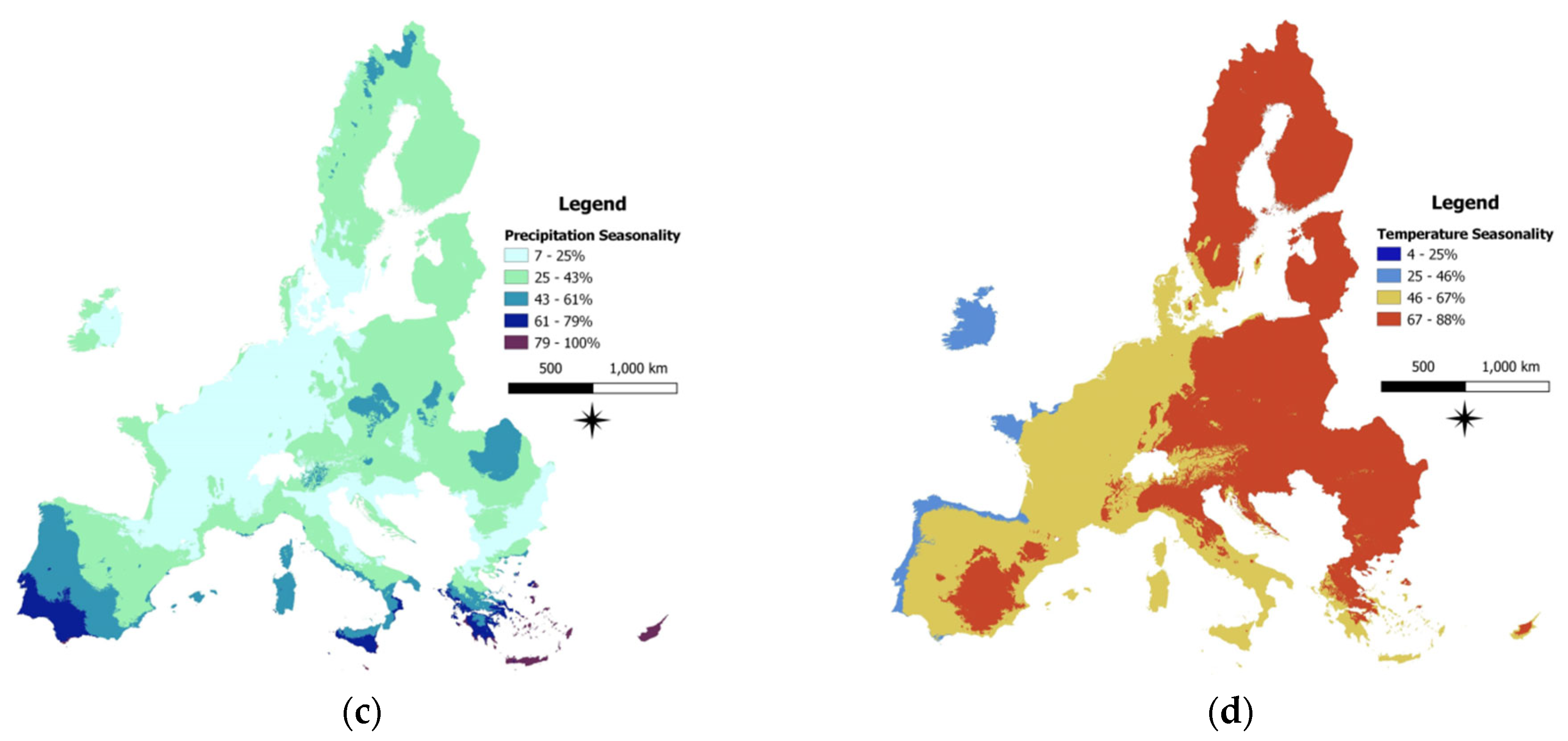
2.4.3. Bioclimatic Factor

The bioclimatic variables used (Figure 4) represent annual trends and seasonality and are derived from the WorldClim version 2.1 climate data for the years 1970–2000. WorldClim bioclimatic variables are derived from the monthly temperature and rainfall values to generate more biologically meaningful variables [33].
Specifically, we used the following bioclimatic variables:
  • Annual mean temperature. The annual mean temperature approximates the total energy input for an ecosystem. The average temperature for each month, and then the average of these results over 12 months, were used.
  • Temperature seasonality CV (standard deviation × 100). Temperature seasonality expresses the amount of temperature variation over a particular period based on the ratio of the standard deviation of the monthly mean temperatures to the mean monthly temperature (also known as the coefficient of variation, i.e., CV). The larger this percentage is, the greater the variability in temperature.
  • Annual precipitation. This is the sum of all total monthly precipitation values. Annual total precipitation approximates the total water input and is, therefore, useful when determining the importance of water availability.
  • Precipitation seasonality (Coefficient of Variation). It is the ratio of the standard deviation of the monthly total precipitation to the mean monthly total precipitation. It provides a percentage of precipitation variability, where a larger percentage represents greater variability in precipitation.

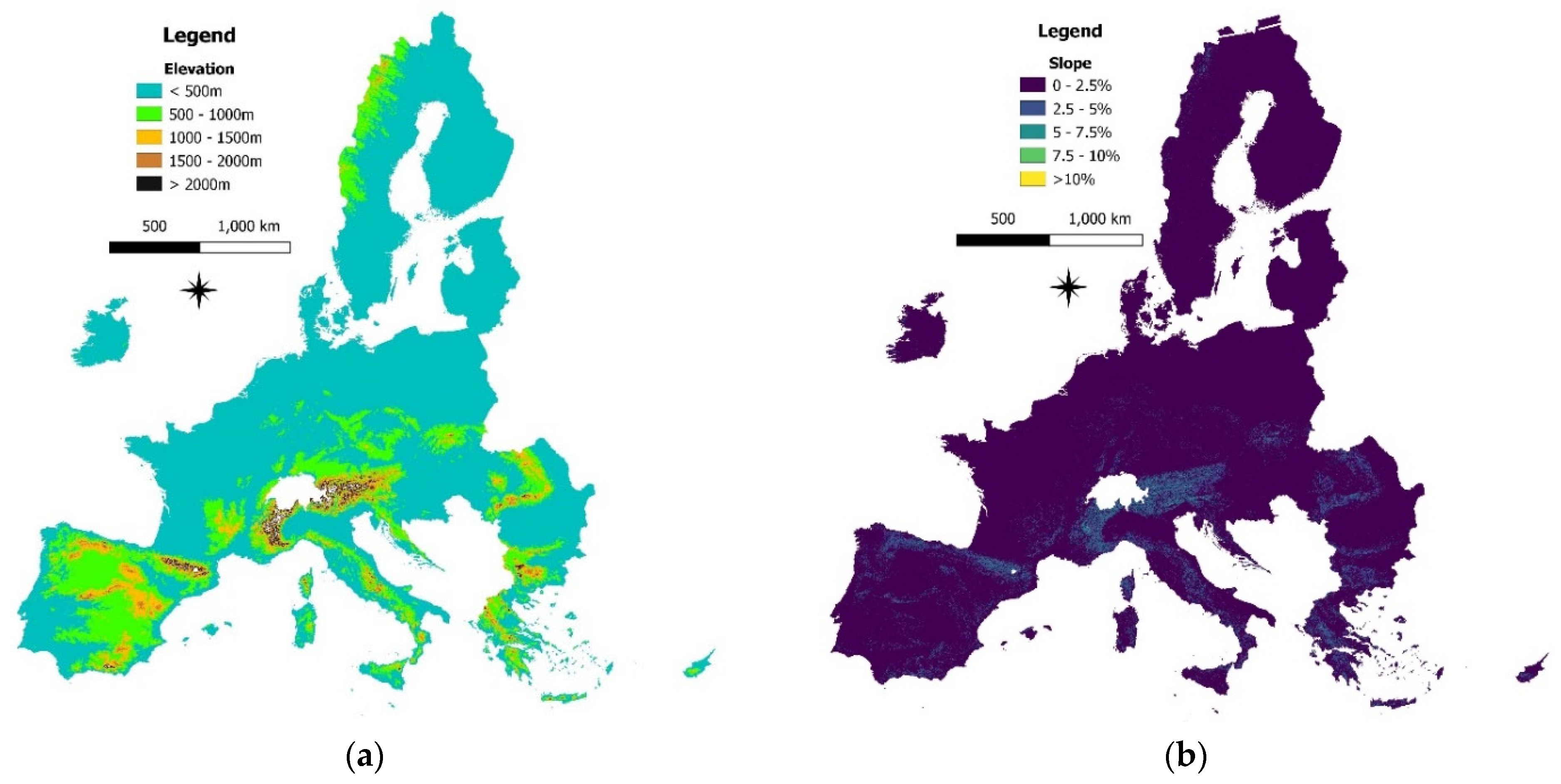
2.4.4. Topographic Factor

To derive the topographical information, the EU-DEM v1.1 and Derived Products were collected from the Copernicus, the European Union’s Earth observation program. Elevation, slope (Figure 5), and aspect maps of the EU at 25 × 25 m pixel size were used. The classes of these three variables were scaled linearly in regular intervals as follows:
  • Elevation was classified into five classes: <500 m, 500–1000 m, 1000–1500 m, 1500–2000 m, and >2000 m.
  • Slope was divided into five levels: 0–2.5°, 2.5–5°, 5–7.5°, 7.5–10° and >10°.
  • Aspect was classified into eight exposures (N, NE, E, SE, S, SW, W, NW).

2.4.5. Soil Factor

Six soil variables were used (Figure 6), which have a direct influence on productivity. All soil data were downloaded from the European Soil Database (ESDB) of the JRC [34]. JRC created several layers for soil properties based on data from the European Soil Database, in combination with data from the Harmonized World Soil Database and Soil-Terrain Database. The layers in this study include total organic carbon content, available water content, and textures of topsoil and subsoil, on the same scales as in their original data source [35].
Details about these soil variables are the following:
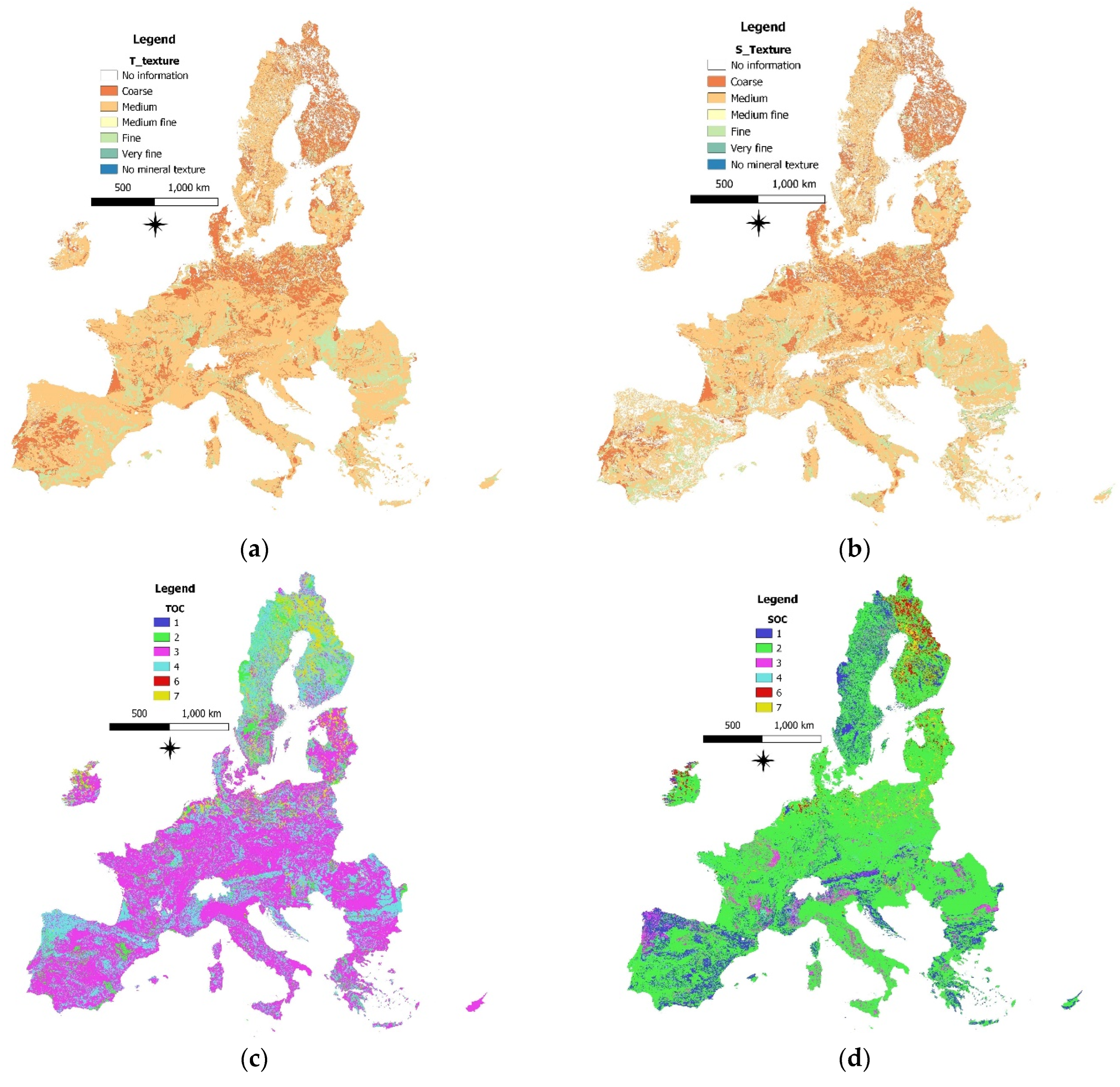
  • Total organic carbon content. Soil organic carbon pools have received increasing attention from policymakers at national and sub-national levels because of their relevance to agriculture and food security, climate change, air and water pollution, and biodiversity [36]. Organic carbon serves as a soil conditioner, nutrient source, substrate for microbial activity, preserver of the environment, and the major determinant for sustaining or increasing agricultural productivity [37]. We classified and analyzed both topsoil and subsoil organic carbon separately. Six classes were considered: 0–1%, 1–2%, 2–6%, 6–12.5%, 12.5–25%, and >25%.
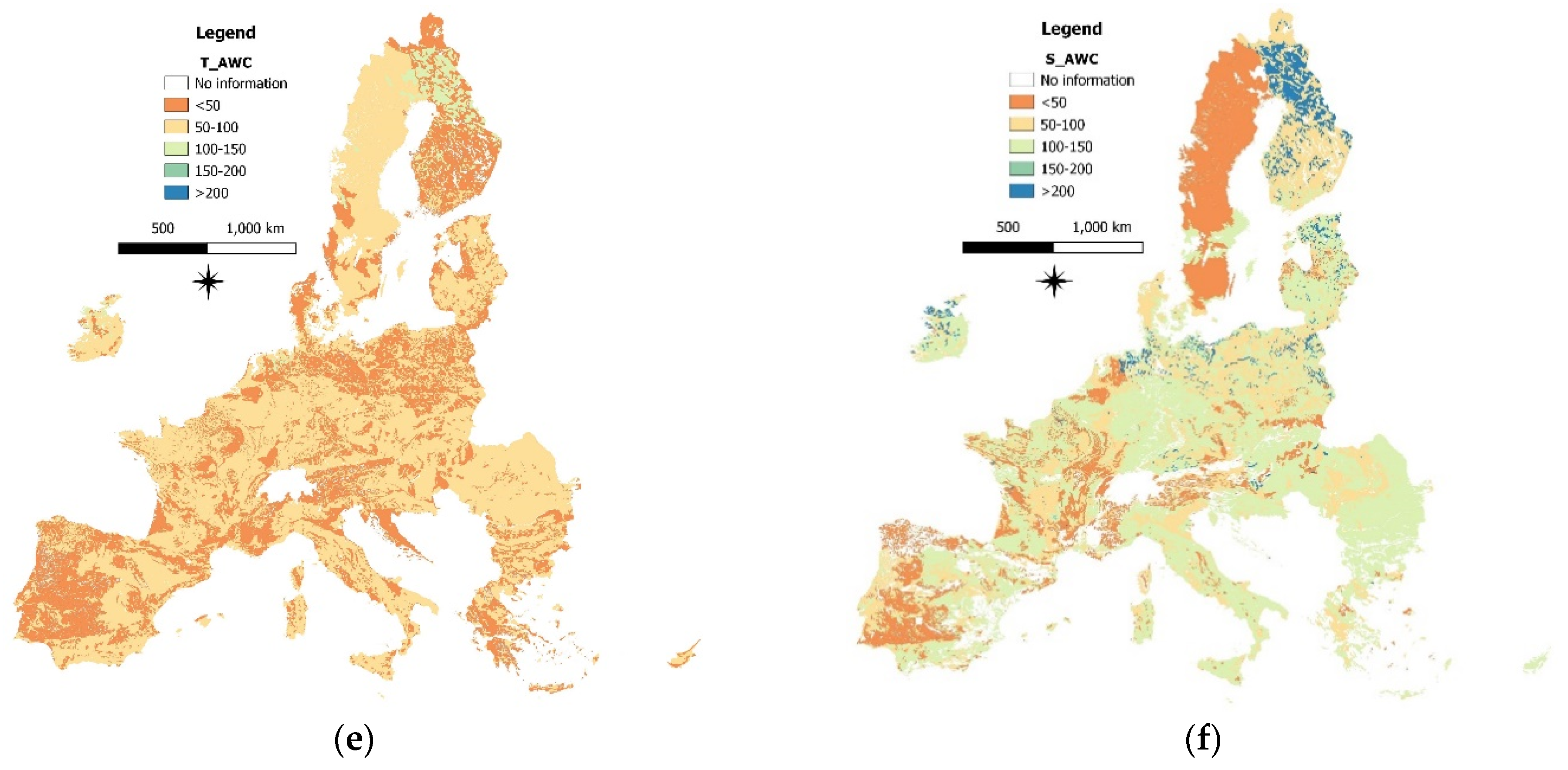
  • Available water content. The soil’s available water content is crucial in agricultural systems, as soil is the main source of water for plant uptake. Soil water governs the soil’s physical condition and can affect the soil’s chemical and biological conditions, such as the plant uptake of nutrients and the activity of soil organisms [38]. The available water content used here is a volumetric parameter describing the water content between the field capacity and the permanent wilting point [39]. It is a function of field capacity, permanent wilting point, presence of coarse fragments, and depth [35]. Both topsoil and subsoil available water content were spatially analyzed after being categorized into five classes: <50 mm, 50–100 mm, 100–150 mm, 150–200 mm, and 200–250 mm.
  • Texture. Texture is one of the most important properties of soil, and it greatly affects crop production, land use, and applied management. Soil texture is directly related to nutrient retention and drainage capabilities, e.g., coarser soils exhibit lower retention of nutrients and water [40]. Classification of soil texture was implemented according to Table 2 [35]. Both topsoil and subsoil textures were spatially analyzed.

2.4.6. Socioeconomic Factor

Three primary socioeconomic factors, which are general enough and are expected to impact the adoption of agroforestry at a local level [41], were considered: age, employment, and population density. Data on age and employment were derived from EU NUTS Level 3 maps, including 1166 regions. The NUTS classification (Nomenclature of territorial units for statistics) is a hierarchical system for dividing up the economic territory of the EU for the purpose of the collection, development, and harmonization of European regional statistics, and the socioeconomic analyses of the regions [42]. Data refer to 2018, and the median values were used. For the population density, we used the 1 km population density grid disaggregated with Corine land cover 2000 [43].

2.5. Spatial Statistical Analysis and Spatial Relationships Modeling

A first level of spatial statistical analysis at a wider extent was performed, finding that silvopasture was the prevalent agroforestry system. The results from this analysis were used as a guide for further modeling the spatial relationships to a more concentrated extent. The latter analysis was performed using the MaxEnt software 3.4.4 [44] to model the land suitability of the most common agroforestry system (SilvoPastoral) in the Mediterranean bioregion, which is the most multitudinous bioregion regarding agroforestry. In order to mitigate the likelihood of model overfitting caused by variable collinearity, which may have an impact on the model’s ability to be applied spatially or temporally [45], the correlation matrix was used to exclude highly correlated variables (with a Pearson correlation coefficient greater than 0.7 or less than −0.7). As there have been notable concerns about the utilization of MaxEnt’s default feature classes and regularization parameter options that can lead to unnecessary model complexity or over-fitting [46], we employed a combination of model settings by utilizing version 2.0.2 of the ENMevalR package [47].
The variability of SilvoPastoral systems has been identified by several authors [48,49,50], as well as the variability of these systems in the Mediterranean bioregion [50,51], pointing out the vegetation as the main differentiating factor along with humans and animals. Therefore, to increase the homogeneity of the area under study, we used the division of the Mediterranean bioregion into ecoregions (Figure 3), and we further analyzed three of them in the Aegean, Adriatic, and Iberian regions, as explained in Section 2.4.1.
We tested 36 candidate models for the modeling process of the three ecoregions under study by integrating five feature classes (linear; linear and quadratic; hinge; linear, quadratic, and hinge; linear, quadratic, hinge, and product) and nine regularization multiplier values (1 to 5 in 0.5 increments) [47], and we used each ecoregion as the background extent. MaxEnt offers various options for cross-validation, wherein presence locations are typically divided into training data to fit the model and test data to assess model predictions. The most common approach is k-fold cross-validation, where the data are divided into k-independent subsets [52]. For each subset, the model is trained using k − 1 subsets and assessed on the kth subset. Here, we used five subsets. To determine the model with the most suitable model settings, we selected the model with the lowest Akaike information criterion [53] value corrected for small sample sizes (AICc). This criterion penalizes model over-fitting.
To evaluate the model’s performance, metrics of model fit are necessary [54]. In the MaxEnt literature, the area under the receiver-operating curve (AUC) has emerged as the most popular metric for model evaluation. AUC is a threshold-independent measure of predictive accuracy that relies solely on the ranking of locations. It represents the probability that a randomly chosen presence location will be ranked higher than a randomly chosen background site. AUC values that are higher indicate that the models are more effective in distinguishing between conditions at the occurrence locations that were not used for training and the ones at the background sites [47]. Values that are close to 0.5 are as informative as random models. For our analysis, we defined models with an AUC > 0.9 as excellent, 0.8–0.9 as good, 0.7–0.8 as fair, and <0.7 as poor, based on previously established criteria [55].
After identifying the optimal model settings, we used MaxEnt to run the selected model with 10 cross-validated replications, without threshold values, and with the same bias file. The remaining settings were kept at default values. For example, no weights were applied to specific variables for estimating suitability. To assess the contribution of each variable to the model, we used Jackknife testing. This variable importance is the percent decrease in the AUC of the model when that particular variable’s values are randomly permuted. Subsequently, we produced response curves to evaluate how each variable impacted the distribution of the SilvoPastoral activity. We created three maps for SilvoPastoral suitability, each for every ecoregion, categorized into five suitability classes: very low suitability (<0.2); low suitability (0.2–0.4); moderate suitability (0.4–0.6); high suitability (0.6–0.8); and very high suitability (>0.8).

3. Results

3.1. Spatial Statistical Analysis

The majority of the 5100 sites characterized as agroforestry belong to the SilvoPastoral system (4400 observed sites), followed by the AgroPastoral system with 514 observations, the AgroSilvo system with 161 sites, and the AgroSilvoPastoral system with 25 observed sites (Figure 7).

3.1.1. AgroPastoral System

Most of the AgroPastoral system observations were located in the Mediterranean bioregion (63.5%), followed by the Continental bioregion (24.5%). Regarding topography, almost all AgroPastoral sites were observed at altitudes lower than 1000 m, and on gentle slopes (up to 2.5°), while the aspect did not indicate any trend. With reference to bioclimatic factors, the majority of AgroPastoral system observations are in areas with annual precipitation between 300–800 mm, and annual mean temperature between 10–20 °C. Precipitation seasonality (CV) is quite shared in the AgroPastoral sites observed, while temperature seasonality (CV) values ranged from 46–88% for the majority of the AgroPastoral system observations. Regarding the soil properties, most of the AgroPastoral observations are allocated to topsoils and subsoils with less than 2% organic carbon, and with medium texture, according to the ESDB classification scheme, while their available water capacity is differently distributed between the higher and lower levels of soil. The median age of the resident population of the regions where the AgroPastoral system was observed is 55.5 years old, the median population density is 57.4 persons per km2, and the median number of employed residents is 13.5 thousand persons.

3.1.2. AgroSilvo System

The majority of the AgroSilvo system observations are located in the Mediterranean bioregion (76%). Regarding topography, all AgroSilvo sites were observed at altitudes less than 1500 m, and almost all on gentle slopes (up to 2.5°), while the aspect did not present any trend. With reference to bioclimatic factors, most of AgroSilvo system observations receive an annual precipitation between 300–800 mm and have an annual mean temperature between 10–20 °C. Almost half of the AgroSilvo sites have a precipitation seasonality (CV) in the 43–61% range, while temperature seasonality (CV) values range from 46–88% for the majority of the AgroSilvo system observations. Regarding the soil properties, the majority of the AgroSilvo observations are allocated to topsoils and subsoils with less than 2% organic carbon, and with medium texture, whereas their available water capacity is differently distributed between the higher and lower levels of soil. The median age of the resident population of the regions where the AgroSilvo system was observed is 53.4 years old, the median population density is 52.5 persons per km2, and the median number of employed residents is 14,000 persons.

3.1.3. AgroSilvoPastoral System

AgroSilvoPastoral sites were observed only in the Mediterranean bioregion at elevations lower than 1000 m and with a gentle slope (up to 2.5°), and they are located in all aspects. Most AgroSilvoPastoral observations have annual precipitation between 300–800 mm, and at all of them the annual mean temperature lies between 10–20 °C. Precipitation seasonality (CV) values range from 43–61% for the majority of sites (76%), and temperature seasonality (CV) ranges mainly between 46–67%. Their soil organic carbon content is lower than 2%, with medium texture and an available water capacity of less than 50 mm for most of them. For the AgroSilvoPastoral system observations, the median age of the resident population is 57.4 years, the median population density is 31.5 persons per km2, and the median number of employed residents is 14,000.

3.1.4. SilvoPastoral System

The majority of the SilvoPastoral sites observed in the Mediterranean bioregion occurred at less than 1000 m of altitude, less than 2.5° slope, and in all aspects. Referring to bioclimatic factors, the observations’ allocations vary in the height of the annual precipitation and annual mean temperature, as well as for the precipitation and temperature seasonality (CVs), having values from almost all the classes used for their classification. More than half of the sites have an organic carbon content lower than 2%, a medium texture, and an available water capacity of less than 100 mm. For the SilvoPastoral system observations, the median age of the population is 56.6 years, the median population density is 39.4 persons per km2, and the median number of employed persons is 11,000.

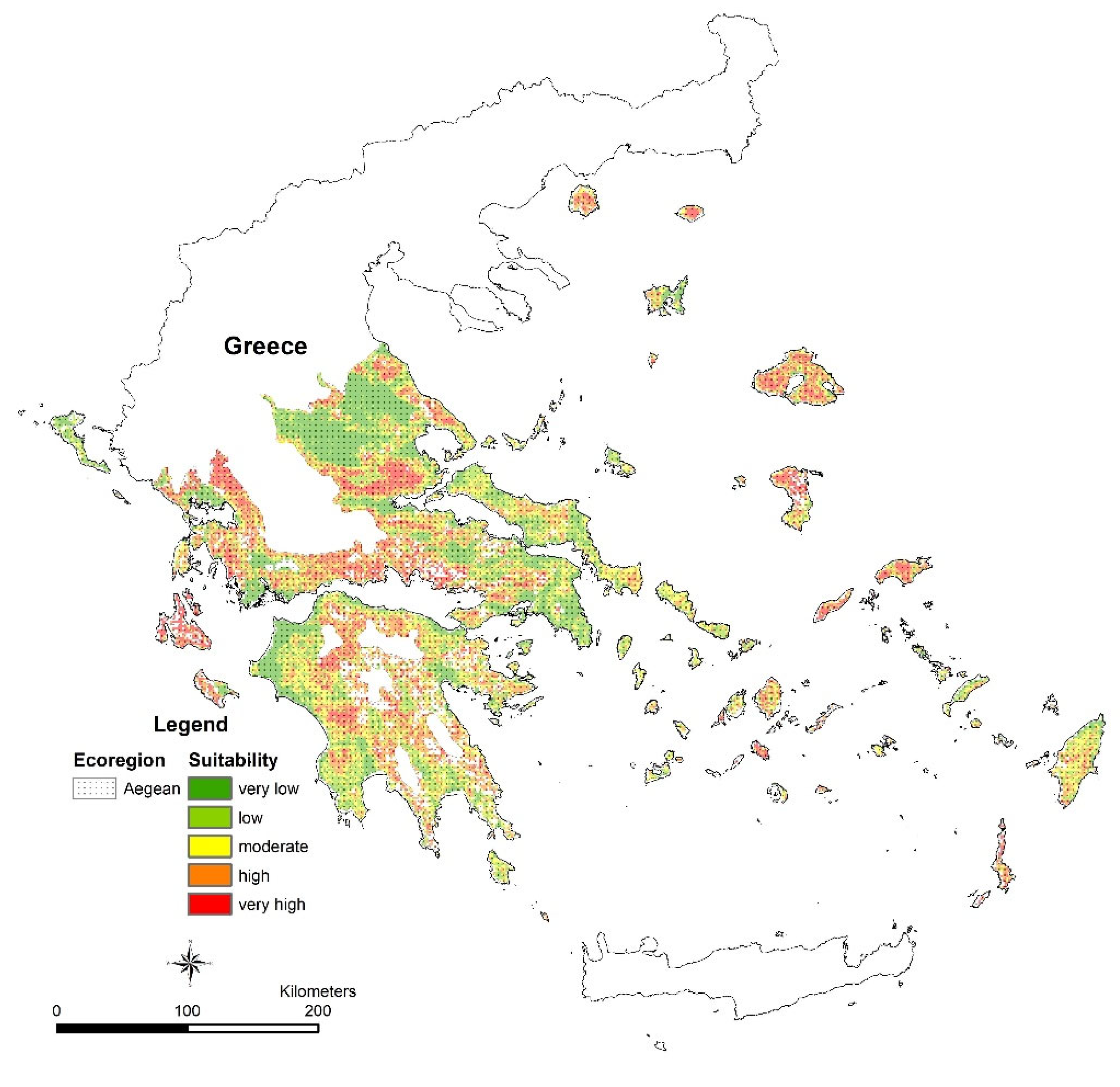
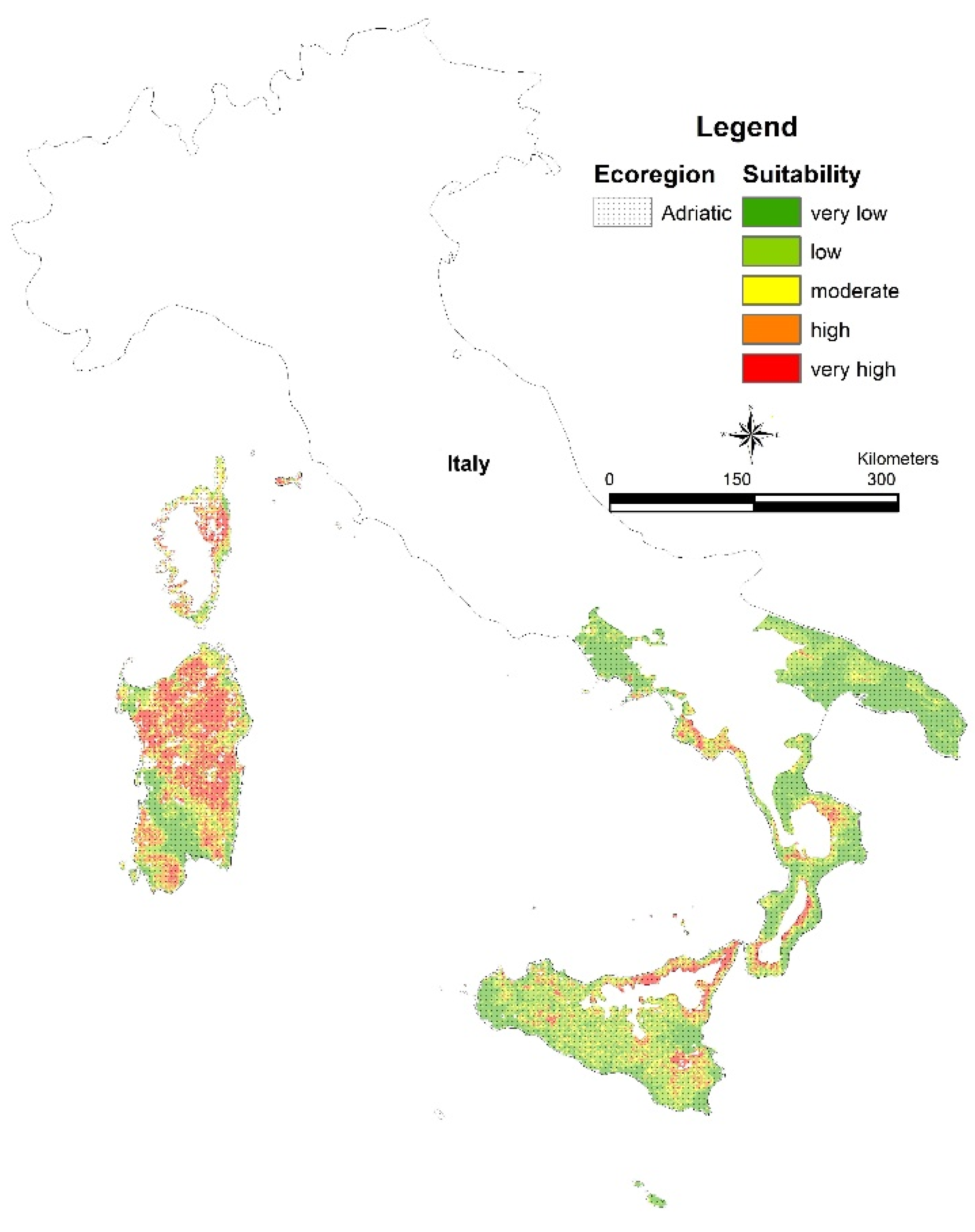
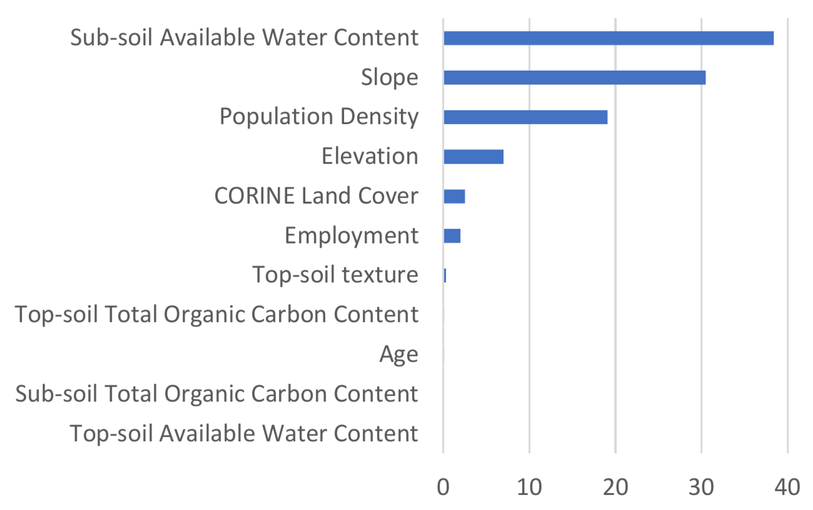
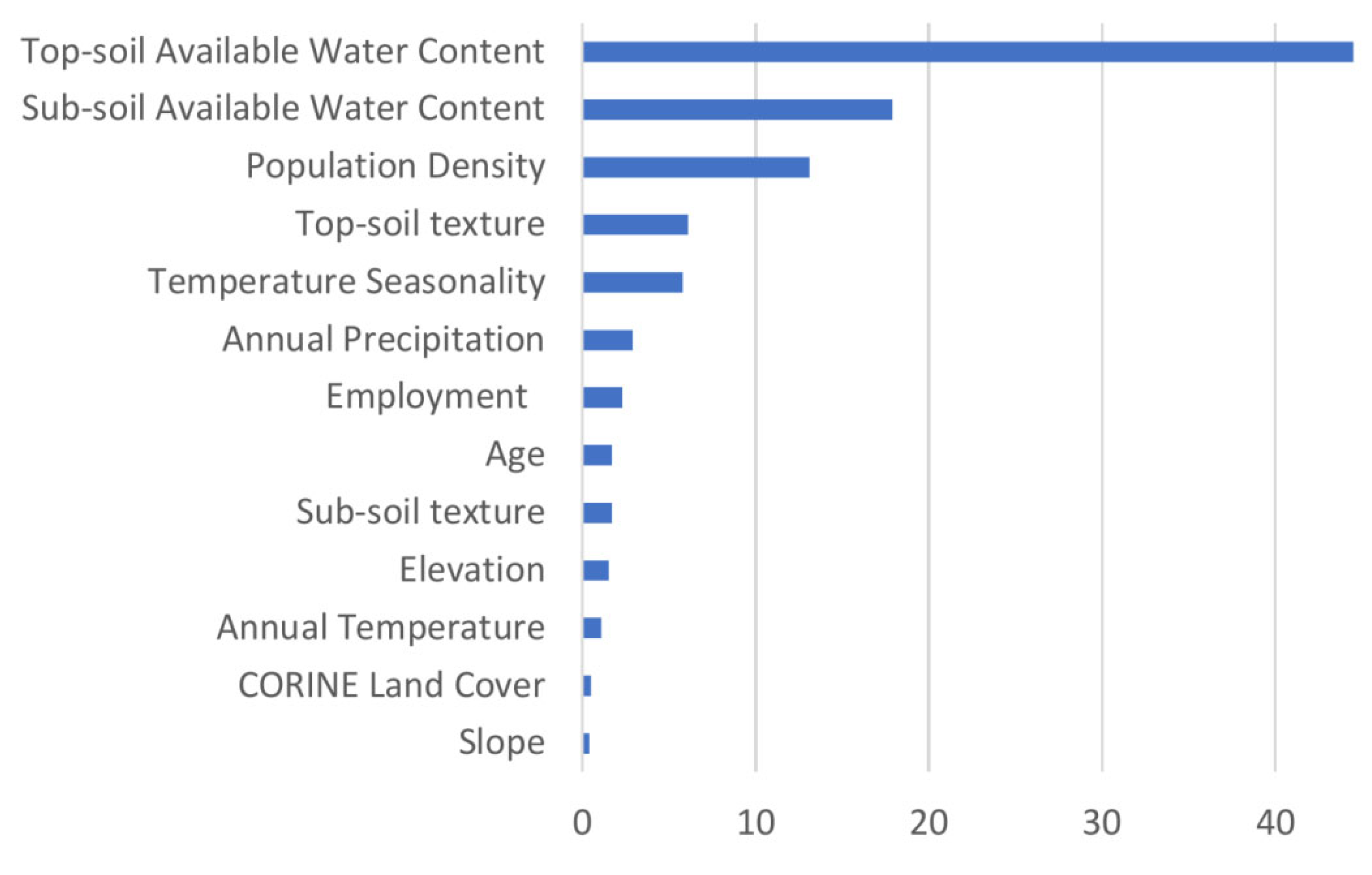
3.2. Land Suitability for SilvoPastoral Agroforestry

The most multitudinous ecoregions regarding the observed SilvoPastoral systems (MaxEnt) are: (i) the Aegean and West Turkey sclerophyllous and mixed forests; (ii) the Tyrrhenian–Adriatic sclerophyllous and mixed forests; and (iii) the Iberian sclerophyllous and semi-deciduous forests.

3.2.1. Aegean & West Turkey Sclerophyllous and Mixed Forest Modeling

The average AUC test for the replicate runs was 0.774, and the standard deviation was 0.069. Figure 8 shows the results of the Jackknife test of variable importance. The higher the contribution, the more impact that variable had on predicting the occurrence of SilvoPastoral use. The variable with the highest gain when used in isolation is the subsoil available water content, which, therefore, appears to have the most useful information by itself. The values shown are averages over replicate runs. Based on the MaxEnt model, the currently suitable area (predicted suitability ≥ 0.6) for SilvoPastoral use at the Aegean and West Turkey sclerophyllous and mixed forest ecoregion (EU countries) is 19.820 km2, which equals 32% of the total area of the ecoregion (Figure 9).

3.2.2. Adriatic Sclerophyllous and Mixed Forests Modeling

The average AUC test for the replicate runs was 0.793, and the standard deviation was 0.098. Figure 10 illustrates the results of the Jackknife test used to determine the significance of variables. The Corine land cover had the greatest gain when utilized alone, indicating that it possesses the most informative value by itself. Based on the MaxEnt model, the currently suitable area (predicted suitability ≥ 0.6) for SilvoPastoral use at the Tyrrhenian–Adriatic sclerophyllous and mixed forests ecoregion is 24.139 km2 that equals 30% of the total area of the ecoregion (Figure 11).

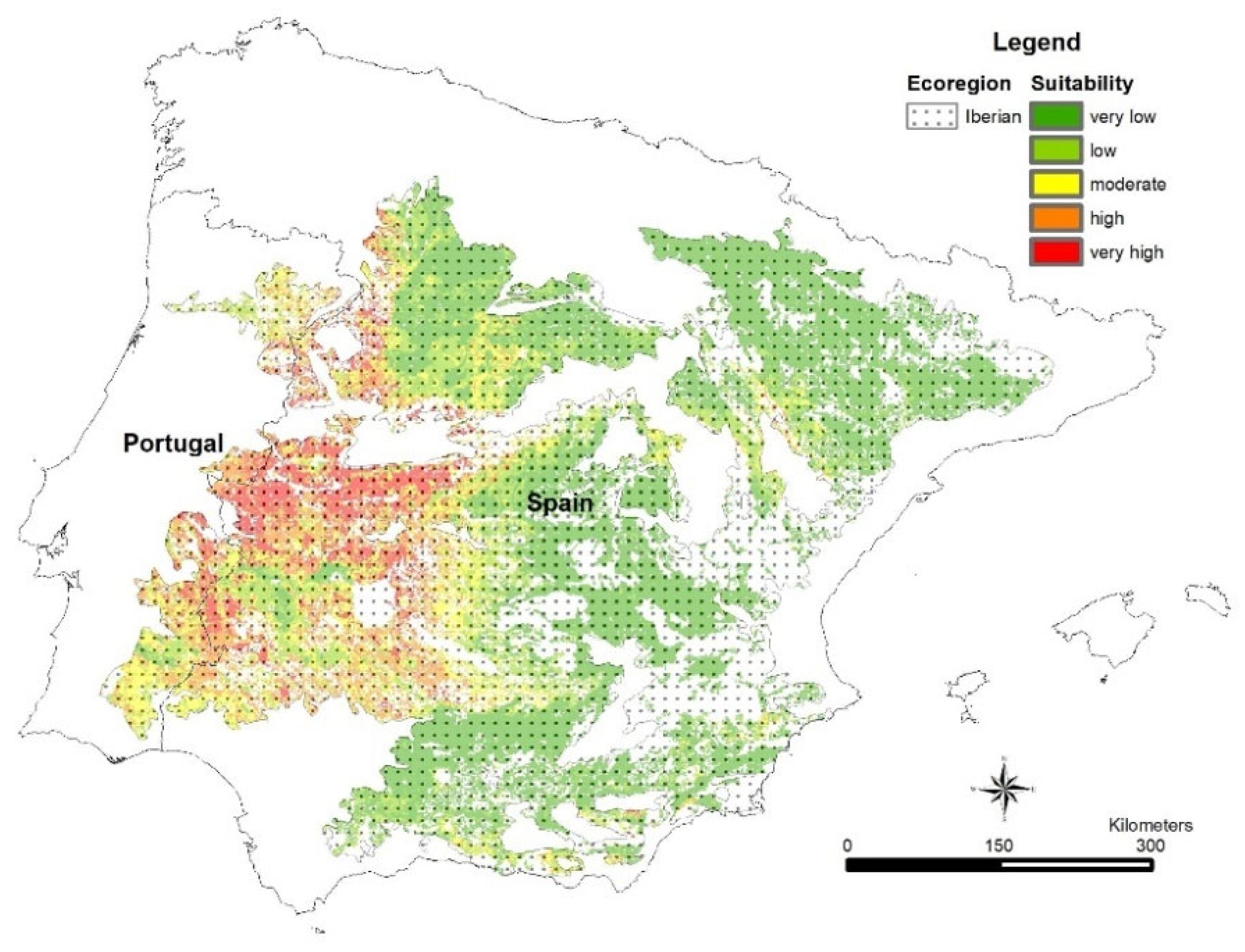
3.2.3. Iberian Sclerophyllous and Semi-Deciduous Forests Modeling

The average AUC test for the replicate runs is 0.817, and the standard deviation is 0.030. The findings of the Jackknife test for variable significance are depicted in Figure 12. The topsoil available water content demonstrates the highest gain when used in isolation, signifying that it is the most informative variable alone. Based on the MaxEnt model, the currently suitable area (predicted suitability ≥ 0.6) for SilvoPastoral use in the Iberian sclerophyllous and semi-deciduous forests ecoregion is 66.072 km2, representing 22% of the total area of the ecoregion (Figure 13).
Figure 9. Land use suitability for SilvoPastoral use at the Aegean and West Turkey sclerophyllous and mixed forests.
Agriculture 14 01222 g009
Figure 10. Analysis of variable contributions (%) in SilvoPastoral use at the Tyrrhenian–Adriatic sclerophyllous and mixed forests. The values displayed in the figure represent the average of replicate runs.
Agriculture 14 01222 g010
Figure 11. Land-use suitability for SilvoPastoral use at the Tyrrhenian–Adriatic sclerophyllous and mixed forests.
Agriculture 14 01222 g011

4. Discussion

With previous studies estimating the extent of European agroforestry [6,56], the present study followed calls in the literature pointing to the lack of region-level information about the socioeconomic and ecological suitability of agricultural lands for accommodating agroforestry practices in the EU [7]. Our spatial analysis at this wider extent of the EU showed that the majority of agroforestry systems were found at lower altitudes and gentler slopes. Bioclimatic factors were also consistent among agroforestry systems, with annual precipitation ranging between 300–800 mm and annual mean temperature between 10–20 °C. Regarding soil, there was a high frequency of occurrence in topsoils and subsoils with less than 2% organic carbon, and of medium texture. The median age of the resident populations was above 50 years old, whereas the population densities and numbers of employed residents varied among agroforestry systems.
Focusing on the dominant agroforestry system, which is concentrated in three Mediterranean ecoregions, the most important variables for the occurrence of this SilvoPastoral system were subsoil available water content for the Aegean and West Turkey sclerophyllous and mixed forests, land cover for the Tyrrhenian–Adriatic sclerophyllous and mixed forests, and topsoil available water content for the Iberian sclerophyllous and semi-deciduous forests. We hereafter discuss our categorization and identification of agroforestry systems, as well as the social-ecological suitability patterns related to the occurrence of these systems, concluding with the policymaking implications of the social-ecological conditions for agroforestry.

4.1. Definition and Identification of Agroforestry Systems

Although the different categories of land use on the basis of the LUCAS database have been previously defined for the estimation of the spatial extent of European agroforestry [6], we had to similarly define and synthesize our own classification scheme from LUCAS as a first step in creating our analyses’ dependent variables, i.e., the agroforestry systems.
We found that agroforestry in the EU is dominated by the SilvoPastoral system, with most observations located in the Mediterranean bioregion. The AgroPastoral system has the second-highest number of observations, followed by the AgroSilvo and AgroSilvoPastoral systems. The majority of AgroPastoral and AgroSilvo system observations are located again in the Mediterranean bioregion, whereas AgroSilvoPastoral sites are observed exclusively in this bioregion. Our results about the landscape dominance of the livestock-related systems of SilvoPastoral and AgroPastoral agroforestry agree with previous findings about the prevalence of the equivalent category of livestock agroforestry in the EU and, especially, in Southern Europe [6]. Although the definition of the agroforestry categories in the latter study differs from our definition, it is possible to identify overlaps between the categories of the two schemes because the definitions are explicitly stated in both studies. The latter study adopted a more product-oriented classification scheme, whereas our definitions are more structure-oriented. Future studies with an approach similar to the present study can adopt a more product-oriented definition of agroforestry systems to encourage a more economics-oriented analysis of the prospects and potential of agroforestry in Europe. In general, there can be different schemes for classifying agroforestry, and their methodology depends on the aims of the individual studies [57]. As long as the definitions are formally stated, it can be commonly easy to identify similarities and differences between the classifications, mainly because all definitions are inevitably based on the three structural components of agroforestry: crops, woody perennials, and pastures.
Since the aim of the present study was to analyze the relation between the occurrence of the different agroforestry systems in specific locations and the social-ecological conditions at these localities, we limited our data to the raw observations at the sites of the LUCAS database. Consequently, there was no reason to proceed with any type of area estimation, such as via spatial clustering of these site observations [6]. A disadvantage of this approach is that we could not provide estimations for the extent of our agroforestry categories to more safely validate the present classification scheme against previous estimates of agroforestry areas. At the same time, though, this omission of estimating the extent also provides an advantage towards our aims. In specific, a known pitfall that can lead to the identification of artifact agroforestry localities arises when we need to group together nearby sites for the sake of estimating areas. In some cases, the grouped sites will have different land cover, e.g., grassland and forest, which, when lumped together in a cluster, could be taken together as agroforestry, although agroforestry in the individual sites was not a common practice [6,58]. By only using the raw data from the site observations of LUCAS, we believe that we have reduced this risk of overestimating the occurrence of agroforestry in our analyses.
Additionally, the LUCAS database poses the risk of underestimating the occurrence of agroforestry-related land cover and land use [6]. This stems from the fact that the LUCAS field sampling has been limited to a certain distance from the road network. In that way, the sampling might have missed agroforestry sites in mountains and other remote areas, especially since the landscapes of the Mediterranean are usually characterized by such localities that are commonly used for agroforestry. Another related reason is the frequently low density of livestock in such large areas, which can lead to minimal signs of grazing, captured by the surveyors recording these sites as not having “signs of grazing”.
Nevertheless, since the LUCAS data were obtained and analyzed consistently, we believe that our study could capture (based on the raw data of site observations) any consistent patterns and conditions related to the suitability of agroforestry in Europe, as we discuss next.

4.2. Social-Ecological Factors of Agroforestry Suitability

Agroforestry in general and, in particular, its prevalent silvopastoral form have long co-evolved with the local ecological and human communities, mainly in the harsher environments of Europe’s south [51]. These environments pose demanding social and ecological pressures, shaping the Mediterranean landscape toward an essentially widespread agroforestry system [59]. As a result of these co-evolving processes, the locations where agroforestry and, especially, silvopastoralism are practiced were found in the present study to occur within ecoregions of mainly sclerophyllous and mixed or semi-deciduous forests. Such plant communities are characterized by their ability to withstand the highly variable seasonal climatic conditions of the Mediterranean zone, mitigating the periods of forage limitation, and, consequently, sustaining herbivory for livestock agroforestry [60,61].
Nevertheless, such marginal areas have not adopted modern practices of agroforestry but have rather been exploited more opportunistically to sustain local communities in the short term [62]. As a matter of fact, social-ecological characteristics such as the hilly or mountainous topography, the low soil fertility, the remoteness from urban centers and road networks, and the more unfavorable climatic conditions have generally limited the adoption of intensive agriculture in these marginalized areas of the Mediterranean region [2,63]. Our findings suggest that agroforestry practices in the study bioregions are influenced by a range of such factors, including bioclimatic conditions, soil properties, and demography. For example, the distribution of AgroPastoral observations with respect to bioclimatic variables suggests that agroforestry practices in the study area are mainly concentrated in areas with moderate rainfall and temperature conditions. Our study’s identification of the importance of bioclimatic conditions on suitability agrees with previous studies’ findings that consider that the climatic conditions at the regional-to-local scale can facilitate the establishment of agroforestry systems [16,63]. Other variables that exhibited high importance for the silvopastoral system were soil water and organic content. Indeed, livestock agroforestry in mountainous regions, such as the ones we identified as important for this agroforestry system, are covered by historical grasslands, which continue to persist despite land abandonment [64,65,66]. These grasslands are important for sustaining livestock farming, e.g., in the form of transhumance [64], and their persistence is attributed to the poorer soil conditions [67].
These ecological conditions in Europe’s Mediterranean regions have selected silvopastoralism in general, but also specific livestock species in particular. Small ruminants, such as sheep and goats, are easier to control than cattle for the variable stocking rates that are required to be adjusted under the variable forage availability that stems from the higher Mediterranean seasonality and harsher summer conditions [68,69,70]. Additionally, the grazing method of sheep and goats is more suitable for the Mediterranean environment than that of the cattle. Unlike sheep and goats that just cut the grass with their teeth, cows use their tongues to pull up plants even from the roots, creating patches of bare ground that are more difficult to regrow under the warmer and drier Mediterranean conditions [71].
We additionally found that another variable—the land cover—was important in the prediction of the silvopastoral system in the ecoregion of Tyrrhenian–Adriatic sclerophyllous and mixed forests. Land use and land cover have been previously shown to be strongly related to the occurrence of specific vegetation types [72] and agroforestry systems [73]. Even under the land abandonment manifested in these marginal areas of the Mediterranean, silvoarable systems can even increase their extent due to the afforestation of abandoned agricultural crops [73]. According to the latter authors, such systems are not expected to be managed systematically and intensively, or with the aim of harvesting the woody components. This is because farmers, foremost, usually tend to quit the treatment of agroforestry’s woody component when they are financially pressing. In general, such marginal systems are financially vulnerable due to unfavorable environmental conditions, lower productivity, remoteness, and funding competition with the intensive agricultural systems of the lowlands [74,75], as we further illustrate next while discussing the socioeconomic predictors of agroforestry suitability.
In general, there are indications that agroforestry and, especially, South European silvopastoralism are among the most vulnerable land uses to these socioeconomic changes of the recent decades [13]. These trends of expanding forests and contracting grassland and silvopastoral areas have been reported in different Mediterranean regions of the Iberian and the Adriatic peninsulas [76,77,78] and have important implications for policymaking related to management and restoration. The importance of land use and cover factors for the identification of agroforestry sites found in this study reflects major socioeconomic changes that occur during the last decades, especially in the Mediterranean countries [11,12]. In particular, land abandonment in the marginal areas of the South has been intensive since World War II, leading to significant changes to these rural and cultural landscapes [79]. Abandonment has been manifested, mainly due to great urbanization and migration waves by young people with low income [80]. The median age of the residents that remain in these marginal areas is almost a decade older than Europe’s overall median age of 44.5 years [42], as we found in our analyses, and they are getting older. Besides the decreases in population densities, this aging of the resident populations leads to a reduction in the workforce that is available to manage the commonly more challenging agroforestry practices, such as the transhumant livestock system, due to the fact that it is more difficult for older people to shepherd their livestock further away from their villages [8]. For the sake of simplicity, we herein recruited three basic socioeconomic variables (age, employment, and density), but future studies can implement more detailed variables, even at the household level, especially variables that express the sense of financial security that is related to the adoption of agroforestry practices [41].

5. Conclusions

Land managers and policymakers should consider the trends of shrubland–woodland increase and cropland–grassland decrease that threaten the traditional landscapes of Europe and, especially, the Mediterranean [81,82]. The importance of studies like the present one relies on the documentation of the extent and characteristics of agroforestry systems, which, despite being so widespread and beneficial in the Mediterranean countries of Europe, have not received due attention because of inadequate definition, monitoring, and analysis [6]. Nevertheless, there is an increasing interest in the contribution of agroforestry to the mitigation of environmental and socioeconomic challenges [2,41].
The EU has included agroforestry practices within the Doha Amendment to the Kyoto Protocol and in the 2015 Paris Agreement [83]. Agroforestry in the EU is supported by the CAP directly via the funding of Pillar I and indirectly via the rural development funding of Pillar II. Direct payments have been recently encouraged because the eligibility criterion for direct payments of land that must have no more than 50 and 100 trees per hectare in the respective periods of 2007–2013 and 2014–2020 has been lifted in the post-2020 period by the European Commission [84]. The removal of this tree density limitation encourages the inclusion of woody perennials in marginal areas to enhance sustainability, foster biodiversity, and mitigate climate change. In that way, the latest CAP is expected to encourage the (re)establishment of 622,000 ha of agroforestry area in the 2023–2027 period [3]. Besides direct payments, indirect payments for rural development are also crucial; for example, to sustain the older people in the regions where observations were made in our analyses. There is a need to ensure that these systems are sustainable in the long term and can continue to provide benefits for future generations. Our findings could be used in economic analyses about the profitability of agroforestry with or without public contribution. In general, agroforestry has appeared to be profitable under a variety of conditions, even without the support of public subsidies, especially in lands where intensification is prohibited due to relatively lower productivity and higher difficulty of cultivation by modern machinery, as in the southern parts of Europe where silvopasture is more suitable among agroforestry systems for such reasons [85,86]. An interesting exercise for future studies would be to compare the temporal change in the extent and suitability factors for agroforestry between the latest year, 2018, of currently available LUCAS data, with agroforestry data from a future LUCAS survey after the application of the new CAP of the 2023–2027 period.
At the same time, there has been an increasing interest in research on agroforestry; for example, about adaptive management for mitigating climate change [87]. Agroforestry systems that include woody species, such as the silvopastoral, are especially expected to contribute more to climate-change mitigation due to their ability to sequester carbon [29,30]. There are signs that the time is ripe for the preservation, restoration, and inclusion of agroforestry systems in the rural areas of the European South, which is also a desire of farmers in many marginal areas where agroforestry is the most efficient and sustainable land use for the poor quality land of such areas [88].
Suitability maps for agroforestry, like the ones we produced in the present study, can provide the baseline for the identification of region-specific management and restoration by policymakers and managers. Indeed, previous studies have similarly suggested that silvopastoral systems can be successfully implemented in Mediterranean ecoregions [89]. In specific, we identified variables that are most informative for predicting the successful implementation of silvopastoral use in specified areas of each ecoregion. For example, due to the dependence of an agroforestry system and the livestock species on the particular environmental conditions of a region, our findings could be used for developing grazing maps for the livestock species that are more likely profitable in each specific region, with data and output of higher resolution. The identified agricultural land that we found suitable for agroforestry is mostly not found or related to intensification. Hence, policymakers and managers would very likely be interested in economically viable and cost-effective management of the selected areas. A reason for the decreased adoption of intensified agroforestry is the lack of subsidies, while agriculture and forestry receive support. Thus, spatially targeted and criteria-based subsidies based on research findings, such as the present study, can guide policymakers, farmers, and land managers about where to establish and maintain agroforestry systems to minimize their costs and maximize their benefits [90,91,92].
Discussing costs and benefits, the scientific literature has recently focused on a shift in the importance and value of agroforestry [93]. Specifically, it appears that direct products and fodder productivity become less important than other values provided by agroforestry due to the emerging conditions of increasing climatic variability in the Mediterranean, frequency of wildfires, erosion, and desertification rates, as well as for cultural reasons associated, for example, with hiking and hunting [93]. Values and services, such as the cost-effective contribution of livestock grazing to reduce wildfire risk and loss of biodiversity, can be nurtured by pasture improvement and other common agroforestry practices, which have been shown to have the greatest contribution [93,94].

Supplementary Materials

The following supporting information can be downloaded at: https://www.mdpi.com/article/10.3390/agriculture14081222/s1, Table S1: LUCAS reference of land cover, codes and component classes.

Author Contributions

Conceptualization, D.F. and I.K.; methodology, D.F.; formal analysis, D.F. and C.A.; data curation, D.F.; writing—original draft preparation, D.F., I.K. and D.A.K.; writing—review and editing, D.F., I.K., D.A.K., C.A. and T.G.P.; visualization, D.F. All authors have read and agreed to the published version of the manuscript.

Funding

This research received no external funding.

Data Availability Statement

The data which support the findings of this study are available from the authors upon reasonable request.

Conflicts of Interest

The authors declare no conflict of interest.

References

  1. Mosquera-Losada, M.R.; McAdam, J.H.; Romero-Franco, R.; Santiago-Freijanes, J.J.; Rigueiro-Rodróguez, A. Definitions and Components of Agroforestry Practices in Europe. In Agroforestry in Europe; Rigueiro-Rodróguez, A., McAdam, J., Mosquera-Losada, M.R., Eds.; Advances in Agroforestry; Springer: Dordrecht, The Netherlands, 2008; Volume 6, pp. 3–19. [Google Scholar]
  2. Rigueiro-Rodríguez, A.; Fernández-Núñez, E.; González-Hernández, P.; McAdam, J.H.; Mosquera-Losada, M.R. Agroforestry Systems in Europe: Productive, Ecological and Social Perspectives. In Agroforestry in Europe; Rigueiro-Rodróguez, A., McAdam, J., Mosquera-Losada, M.R., Eds.; Advances in Agroforestry; Springer: Dordrecht, The Netherlands, 2008; Volume 6, pp. 43–65. [Google Scholar]
  3. Becker, S.; Grajewski, R.; Rehburg, P. Where Does the CAP Money Go?: Design and Priorities of the Draft CAP Strategic Plans 2023–2027; Johann Heinrich von Thünen-Institut: Berlin, Germany, 2022. [Google Scholar]
  4. European Commission; Directorate General for Agriculture and Rural Development; Alliance Environnement. Evaluation Study of the Forestry Measures under Rural Development: Final Report; Publications Office: Luxembourg, 2017. [Google Scholar]
  5. Augère-Granier, M.-L. Agroforestry in the European Union; PE 651.982; European Parliamentary Research Service, European Union: Brussels, Belgium, 2020; pp. 1–11. [Google Scholar]
  6. Den Herder, M.; Moreno, G.; Mosquera-Losada, R.M.; Palma, J.H.N.; Sidiropoulou, A.; Santiago Freijanes, J.J.; Crous-Duran, J.; Paulo, J.A.; Tomé, M.; Pantera, A.; et al. Current Extent and Stratification of Agroforestry in the European Union. Agric. Ecosyst. Environ. 2017, 241, 121–132. [Google Scholar] [CrossRef]
  7. Bārdulis, A.; Ivanovs, J.; Bārdule, A.; Lazdiņa, D.; Purviņa, D.; Butlers, A.; Lazdiņš, A. Assessment of Agricultural Areas Suitable for Agroforestry in Latvia. Land 2022, 11, 1873. [Google Scholar] [CrossRef]
  8. Levers, C.; Müller, D.; Erb, K.; Haberl, H.; Jepsen, M.R.; Metzger, M.J.; Meyfroidt, P.; Plieninger, T.; Plutzar, C.; Stürck, J.; et al. Archetypical Patterns and Trajectories of Land Systems in Europe. Reg. Environ. Chang. 2015, 18, 715–732. [Google Scholar] [CrossRef]
  9. Iglesias, A.; Garrote, L.; Quiroga, S.; Moneo, M. A Regional Comparison of the Effects of Climate Change on Agricultural Crops in Europe. Clim. Chang. 2012, 112, 29–46. [Google Scholar] [CrossRef]
  10. Pazúr, R.; Nováček, J.; Bürgi, M.; Kopecká, M.; Lieskovský, J.; Pazúrová, Z.; Feranec, J. Changes in Grassland Cover in Europe from 1990 to 2018: Trajectories and Spatial Patterns. Reg. Environ. Chang. 2024, 24, 51. [Google Scholar] [CrossRef]
  11. Benayas, J.R.; Martins, A.; Nicolau, J.M.; Schulz, J.J. Abandonment of Agricultural Land: An Overview of Drivers and Consequences. CAB Rev. Perspect. Agric. Vet. Sci. Nutr. Nat. Resour. 2007, 2, 57. [Google Scholar] [CrossRef]
  12. MacDonald, D.; Crabtree, J.R.; Wiesinger, G.; Dax, T.; Stamou, N.; Fleury, P.; Gutierrez Lazpita, J.; Gibon, A. Agricultural Abandonment in Mountain Areas of Europe: Environmental Consequences and Policy Response. J. Environ. Manag. 2000, 59, 47–69. [Google Scholar] [CrossRef]
  13. Chouvardas, D.; Karatassiou, M.; Stergiou, A.; Chrysanthopoulou, G. Identifying the Spatiotemporal Transitions and Future Development of a Grazed Mediterranean Landscape of South Greece. Land 2022, 11, 2141. [Google Scholar] [CrossRef]
  14. Pandey, R.; Aretano, R.; Gupta, A.K.; Meena, D.; Kumar, B.; Alatalo, J.M. Agroecology as a Climate Change Adaptation Strategy for Smallholders of Tehri-Garhwal in the Indian Himalayan Region. Small-Scale For. 2017, 16, 53–63. [Google Scholar] [CrossRef]
  15. Mbow, C.; Van Noordwijk, M.; Prabhu, R.; Simons, T. Knowledge Gaps and Research Needs Concerning Agroforestry’s Contribution to Sustainable Development Goals in Africa. Curr. Opin. Environ. Sustain. 2014, 6, 162–170. [Google Scholar] [CrossRef]
  16. Nath, A.J.; Kumar, R.; Devi, N.B.; Rocky, P.; Giri, K.; Sahoo, U.K.; Bajpai, R.K.; Sahu, N.; Pandey, R. Agroforestry Land Suitability Analysis in the Eastern Indian Himalayan Region. Environ. Chall. 2021, 4, 100199. [Google Scholar] [CrossRef]
  17. Coe, R.; Sinclair, F.; Barrios, E. Scaling up Agroforestry Requires Research ‘in’ Rather than ‘for’ Development. Curr. Opin. Environ. Sustain. 2014, 6, 73–77. [Google Scholar] [CrossRef]
  18. Collins, M.G.; Steiner, F.R.; Rushman, M.J. Land-Use Suitability Analysis in the United States: Historical Development and Promising Technological Achievements. Environ. Manag. 2001, 28, 611–621. [Google Scholar] [CrossRef] [PubMed]
  19. Lopresti, M.F.; Di Bella, C.M.; Degioanni, A.J. Relationship between MODIS-NDVI Data and Wheat Yield: A Case Study in Northern Buenos Aires Province, Argentina. Inf. Process. Agric. 2015, 2, 73–84. [Google Scholar] [CrossRef]
  20. Bilas, G.; Karapetsas, N.; Gobin, A.; Mesdanitis, K.; Toth, G.; Hermann, T.; Wang, Y.; Luo, L.; Koutsos, T.M.; Moshou, D.; et al. Land Suitability Analysis as a Tool for Evaluating Soil-Improving Cropping Systems. Land 2022, 11, 2200. [Google Scholar] [CrossRef]
  21. Zolekar, R.B.; Bhagat, V.S. Multi-Criteria Land Suitability Analysis for Agriculture in Hilly Zone: Remote Sensing and GIS Approach. Comput. Electron. Agric. 2015, 118, 300–321. [Google Scholar] [CrossRef]
  22. Ahmad, F.; Goparaju, L. Geospatial Approach for Agroforestry Suitability Mapping: To Enhance Livelihood and Reduce Poverty, FAO Based Documented Procedure (Case Study of Dumka District, Jharkhand, India). Biosci. Biotechnol. Res. Asia 2017, 14, 651–665. [Google Scholar] [CrossRef]
  23. Phillips, S.J.; Anderson, R.P.; Schapire, R.E. Maximum Entropy Modeling of Species Geographic Distributions. Ecol. Model. 2006, 190, 231–259. [Google Scholar] [CrossRef]
  24. Stockwell, D. The GARP Modelling System: Problems and Solutions to Automated Spatial Prediction. Int. J. Geogr. Inf. Sci. 1999, 13, 143–158. [Google Scholar] [CrossRef]
  25. Heumann, B.W.; Walsh, S.J.; McDaniel, P.M. Assessing the Application of a Geographic Presence-Only Model for Land Suitability Mapping. Ecol. Inform. 2011, 6, 257–269. [Google Scholar] [CrossRef] [PubMed]
  26. Fitzgibbon, A.; Pisut, D.; Fleisher, D. Evaluation of Maximum Entropy (MaxEnt) Machine Learning Model to Assess Relationships between Climate and Corn Suitability. Land 2022, 11, 1382. [Google Scholar] [CrossRef]
  27. d’Andrimont, R.; Yordanov, M.; Martinez-Sanchez, L.; Eiselt, B.; Palmieri, A.; Dominici, P.; Gallego, J.; Reuter, H.I.; Joebges, C.; Lemoine, G.; et al. Harmonised LUCAS In-Situ Land Cover and Use Database for Field Surveys from 2006 to 2018 in the European Union. Sci. Data 2020, 7, 352. [Google Scholar] [CrossRef] [PubMed]
  28. Ballin, M.; Barcaroli, G.; Masselli, M.; Scarnó, M. Redesign Sample for Land Use/Cover Area Frame Survey (LUCAS) 2018; European Commission, Statistical Office of the European Union Publications Office: Luxembourg, 2018. [Google Scholar]
  29. Dmuchowski, W.; Baczewska-Dąbrowska, A.H.; Gworek, B. The Role of Temperate Agroforestry in Mitigating Climate Change: A Review. For. Policy Econ. 2024, 159, 103136. [Google Scholar] [CrossRef]
  30. Kay, S.; Rega, C.; Moreno, G.; Den Herder, M.; Palma, J.H.N.; Borek, R.; Crous-Duran, J.; Freese, D.; Giannitsopoulos, M.; Graves, A.; et al. Agroforestry Creates Carbon Sinks Whilst Enhancing the Environment in Agricultural Landscapes in Europe. Land Use Policy 2019, 83, 581–593. [Google Scholar] [CrossRef]
  31. European Environment Agency (EEA). Biogeographical and Marine Regions in the EU. Available online: https://www.eea.europa.eu/data-and-maps/figures/biogeographical-and-marine-regions-in (accessed on 21 May 2024).
  32. European Environment Agency (EEA). DMEER: Digital Map of European Ecological Regions. Available online: https://www.eea.europa.eu/data-and-maps/figures/dmeer-digital-map-of-european-ecological-regions (accessed on 21 May 2024).
  33. Fick, S.E.; Hijmans, R.J. WorldClim 2: New 1-km Spatial Resolution Climate Surfaces for Global Land Areas. Int. J. Climatol. 2017, 37, 4302–4315. [Google Scholar] [CrossRef]
  34. Panagos, P.; Van Liedekerke, M.; Jones, A.; Montanarella, L. European Soil Data Centre: Response to European Policy Support and Public Data Requirements. Land Use Policy 2012, 29, 329–338. [Google Scholar] [CrossRef]
  35. Hiederer, R. Mapping Soil Properties for Europe: Spatial Representation of Soil Database Attributes; Publications Office of the European Union: Luxembourg, 2013. [Google Scholar]
  36. De Brogniez, D.; Ballabio, C.; Van Wesemael, B.; Jones, R.J.A.; Stevens, A.; Montanarella, L. Topsoil Organic Carbon Map of Europe. In Soil Carbon; Hartemink, A.E., McSweeney, K., Eds.; Springer International Publishing: Cham, Switzerland, 2014; pp. 393–405. [Google Scholar]
  37. Nieder, R.; Benbi, D.K. Carbon and Nitrogen in the Terrestrial Environment; Springer: Dordrecht, The Netherlands, 2008. [Google Scholar]
  38. Asgarzadeh, H.; Mosaddeghi, M.R.; Mahboubi, A.A.; Nosrati, A.; Dexter, A.R. Soil Water Availability for Plants as Quantified by Conventional Available Water, Least Limiting Water Range and Integral Water Capacity. Plant Soil 2010, 335, 229–244. [Google Scholar] [CrossRef]
  39. Richards, L.; Wadleigh, C. Soil Water and Plant Growth. Soil Phys. Cond. Plant Growth 1952, 2, 74–253. [Google Scholar]
  40. Jaja, N. Understanding the Texture of Your Soil for Agricultural Productivity; Virginia Cooperative Extension: Blacksburg, VA, USA, 2016. [Google Scholar]
  41. Glover, E.K.; Ahmed, H.B.; Glover, M.K. Analysis of Socio-Economic Conditions Influencing Adoption of Agroforestry Practices. Int. J. Agric. For. 2013, 3, 178–184. [Google Scholar]
  42. Eurostat. Population Structure Indicators at National Level. Available online: https://ec.europa.eu/eurostat/databrowser/product/page/DEMO_PJANIND (accessed on 9 May 2024).
  43. Gallego, F.J. A Population Density Grid of the European Union. Popul. Environ. 2010, 31, 460–473. [Google Scholar] [CrossRef]
  44. Phillips, S.J.; Anderson, R.P.; Dudík, M.; Schapire, R.E.; Blair, M.E. Opening the Black Box: An Open-source Release of MaxEnt. Ecography 2017, 40, 887–893. [Google Scholar] [CrossRef]
  45. Feng, X.; Park, D.S.; Liang, Y.; Pandey, R.; Papeş, M. Collinearity in Ecological Niche Modeling: Confusions and Challenges. Ecol. Evol. 2019, 9, 10365–10376. [Google Scholar] [CrossRef] [PubMed]
  46. Morales, N.S.; Fernández, I.C.; Baca-González, V. MaxEnt’s Parameter Configuration and Small Samples: Are We Paying Attention to Recommendations? A Systematic Review. PeerJ 2017, 5, e3093. [Google Scholar] [CrossRef] [PubMed]
  47. Muscarella, R.; Galante, P.J.; Soley-Guardia, M.; Boria, R.A.; Kass, J.M.; Uriarte, M.; Anderson, R.P. ENMeval: An R Package for Conducting Spatially Independent Evaluations and Estimating Optimal Model Complexity for MaxEnt Ecological Niche Models. Methods Ecol. Evol. 2014, 5, 1198–1205. [Google Scholar] [CrossRef]
  48. Nair, P.K.R.; Kumar, B.M.; Nair, V.D. An Introduction to Agroforestry: Four Decades of Scientific Developments; Springer International Publishing: Cham, Switzerland, 2021. [Google Scholar]
  49. Etienne, M. Research on Temperate and Tropical Silvopastoral Systems: A Review. In Western European Silvopastoral Systems; Etienne, M., Ed.; Science Update; INRA: Versailles, France, 1996; pp. 5–19. [Google Scholar]
  50. Papanastasis, V.P. Silvopastoral Systems and Range Management in the Mediterranean Region. In Western European Silvopastoral Systems; Etienne, M., Ed.; Science Update; INRA: Versailles, France, 1996; pp. 143–156. [Google Scholar]
  51. San Miguel-Ayanz, A. Mediterranean European Silvopastoral Systems. In Silvopastoralism and Sustainable Land Management. Proceedings of an International Congress on Silvopastoralism and Sustainable Management Held in Lugo, Spain, April 2004; CABI Publishing: Wallingford, UK, 2005; pp. 36–40. [Google Scholar]
  52. Merow, C.; Smith, M.J.; Silander, J.A. A Practical Guide to MaxEnt for Modeling Species’ Distributions: What It Does, and Why Inputs and Settings Matter. Ecography 2013, 36, 1058–1069. [Google Scholar] [CrossRef]
  53. Burnham, K.P.; Anderson, D.R. Model Selection and Multimodel Inference: A Practical Information-Theoretic Approach; Springer: Berlin/Heidelberg, Germany, 2002. [Google Scholar]
  54. Liu, C.; White, M.; Newell, G. Measuring and Comparing the Accuracy of Species Distribution Models with Presence-Absence Data. Ecography 2011, 34, 232–243. [Google Scholar] [CrossRef]
  55. Araújo, M.B.; Pearson, R.G.; Thuiller, W.; Erhard, M. Validation of Species–Climate Impact Models under Climate Change. Glob. Chang. Biol. 2005, 11, 1504–1513. [Google Scholar] [CrossRef]
  56. Burgess, P.J.; Rosati, A. Advances in European Agroforestry: Results from the AGFORWARD Project. Agrofor. Syst. 2018, 92, 801–810. [Google Scholar] [CrossRef]
  57. Nair, P.K.R.; Kumar, B.M.; Nair, V.D. Classification of Agroforestry Systems. In An Introduction to Agroforestry; Springer International Publishing: Cham, Switzerland, 2021; pp. 29–44. [Google Scholar]
  58. Zomer, R.J.; Trabucco, A.; Coe, R.; Place, F. Trees on Farm: Analysis of Global Extent and Geographical Patterns of Agroforestry. ICRAF Work. Pap.-World Agrofor. Cent. 2009, 63, 30. [Google Scholar]
  59. Nerlich, K.; Graeff-Hönninger, S.; Claupein, W. Agroforestry in Europe: A Review of the Disappearance of Traditional Systems and Development of Modern Agroforestry Practices, with Emphasis on Experiences in Germany. Agrofor. Syst. 2013, 87, 475–492. [Google Scholar] [CrossRef]
  60. San, A.; Pérez-Carral, C. Deer and Traditional Agrosilvopastoral Systems of Mediterranean Spain. A New Problem of Sustainability for a New Concept of Land Use. Cah. Options Méditerranéennes 1999, 39, 261–264. [Google Scholar]
  61. Papanastasis, V. Grasslands and Woody Plants in Europe with Special Reference to Greece. In Proceedings of the International Occasional Symposium of the European Grassland Federation, Thessaloniki, Greece, 27–29 May 1999; pp. 15–24. [Google Scholar]
  62. Donham, J.; Venn, R.; Migliorini, P.; Schmutz, U. European State of Agroforestry: An Overview of the Current Policy Contexts. In Proceedings of the 6th European Agroforestry Conference, Nuoro, Italy, 16–20 May 2022; pp. 16–20. [Google Scholar]
  63. Szott, L.T.; Fernandes, E.C.M.; Sanchez, P.A. Soil-Plant Interactions in Agroforestry Systems. For. Ecol. Manag. 1991, 45, 127–152. [Google Scholar] [CrossRef]
  64. Zomeni, M.; Tzanopoulos, J.; Pantis, J.D. Historical Analysis of Landscape Change Using Remote Sensing Techniques: An Explanatory Tool for Agricultural Transformation in Greek Rural Areas. Landsc. Urban Plan. 2008, 86, 38–46. [Google Scholar] [CrossRef]
  65. Kiziridis, D.A.; Mastrogianni, A.; Pleniou, M.; Karadimou, E.; Tsiftsis, S.; Xystrakis, F.; Tsiripidis, I. Acceleration and Relocation of Abandonment in a Mediterranean Mountainous Landscape: Drivers, Consequences, and Management Implications. Land 2022, 11, 406. [Google Scholar] [CrossRef]
  66. Chouvardas, D.; Karatassiou, M.; Tsioras, P.; Tsividis, I.; Palaiochorinos, S. Spatiotemporal Changes (1945–2020) in a Grazed Landscape of Northern Greece, in Relation to Socioeconomic Changes. Land 2022, 11, 1987. [Google Scholar] [CrossRef]
  67. Hinojosa, L.; Napoléone, C.; Moulery, M.; Lambin, E.F. The “Mountain Effect” in the Abandonment of Grasslands: Insights from the French Southern Alps. Agric. Ecosyst. Environ. 2016, 221, 115–124. [Google Scholar] [CrossRef]
  68. Papanastasis, V.P.; Mantzanas, K.; Dini-Papanastasi, O.; Ispikoudis, I. Traditional Agroforestry Systems and Their Evolution in Greece. In Agroforestry in Europe; Rigueiro-Rodróguez, A., McAdam, J., Mosquera-Losada, M.R., Eds.; Advances in Agroforestry; Springer: Dordrecht, The Netherlands, 2009; Volume 6, pp. 89–109. ISBN 978-1-4020-8271-9. [Google Scholar]
  69. Papachristou, T.G.; Platis, P.D. The Impact of Cattle and Goats Grazing on Vegetation in Oak Stands of Varying Coppicing Age. Acta Oecologica 2011, 37, 16–22. [Google Scholar] [CrossRef]
  70. Papachristou, T.G.; Platis, P.D.; Nastis, A.S. Foraging Behaviour of Cattle and Goats in Oak Forest Stands of Varying Coppicing Age in Northern Greece. Small Rumin. Res. 2005, 59, 181–189. [Google Scholar] [CrossRef]
  71. Mosquera-Losada, M.R.; Moreno, G.; Pardini, A.; McAdam, J.H.; Papanastasis, V.; Burgess, P.J.; Lamersdorf, N.; Castro, M.; Liagre, F.; Rigueiro-Rodríguez, A. Past, Present and Future of Agroforestry Systems in Europe. In Agroforestry—The Future of Global Land Use; Nair, P.K.R., Garrity, D., Eds.; Advances in Agroforestry; Springer: Dordrecht, The Netherlands, 2012; Volume 9, pp. 285–312. ISBN 978-94-007-4675-6. [Google Scholar]
  72. Mastrogianni, A.; Kiziridis, D.A.; Karadimou, E.; Pleniou, M.; Xystrakis, F.; Tsiftsis, S.; Tsiripidis, I. Community-Level Differentiation of Grime’s CSR Strategies along a Post-Abandonment Secondary Successional Gradient. Flora 2023, 308, 152399. [Google Scholar] [CrossRef]
  73. Nasiakou, S.; Vrahnakis, M.; Chouvardas, D.; Mamanis, G.; Kleftoyanni, V. Land Use Changes for Investments in Silvoarable Agriculture Projected by the CLUE-S Spatio-Temporal Model. Land 2022, 11, 598. [Google Scholar] [CrossRef]
  74. Keenleyside, C.; Jones, G.; Tucker, G.; Beaufoy, G. High Nature Value Farming throughout EU-27 and Its Financial Support under the CAP Final Report; Publications Office: Luxembourg, 2014. [Google Scholar]
  75. Kiziridis, D.A.; Mastrogianni, A.; Pleniou, M.; Tsiftsis, S.; Xystrakis, F.; Tsiripidis, I. Simulating Future Land Use and Cover of a Mediterranean Mountainous Area: The Effect of Socioeconomic Demands and Climatic Changes. Land 2023, 12, 253. [Google Scholar] [CrossRef]
  76. Ameztegui, A.; Morán-Ordóñez, A.; Márquez, A.; Blázquez-Casado, Á.; Pla, M.; Villero, D.; García, M.B.; Errea, M.P.; Coll, L. Forest Expansion in Mountain Protected Areas: Trends and Consequences for the Landscape. Landsc. Urban Plan. 2021, 216, 104240. [Google Scholar] [CrossRef]
  77. Lasanta-Martínez, T.; Vicente-Serrano, S.M.; Cuadrat-Prats, J.M. Mountain Mediterranean Landscape Evolution Caused by the Abandonment of Traditional Primary Activities: A Study of the Spanish Central Pyrenees. Appl. Geogr. 2005, 25, 47–65. [Google Scholar] [CrossRef]
  78. Pelorosso, R.; Leone, A.; Boccia, L. Land Cover and Land Use Change in the Italian Central Apennines: A Comparison of Assessment Methods. Appl. Geogr. 2009, 29, 35–48. [Google Scholar] [CrossRef]
  79. García-Ruiz, J.M.; Lasanta, T.; Nadal-Romero, E.; Lana-Renault, N.; Álvarez-Farizo, B. Rewilding and Restoring Cultural Landscapes in Mediterranean Mountains: Opportunities and Challenges. Land Use Policy 2020, 99, 104850. [Google Scholar] [CrossRef]
  80. Nori, M.; Farinella, D. Migration, Agriculture and Rural Development: IMISCOE Short Reader; IMISCOE Research Series; Springer International Publishing: Cham, Switzerland, 2020. [Google Scholar]
  81. Delattre, L.; Debolini, M.; Paoli, J.C.; Napoleone, C.; Moulery, M.; Leonelli, L.; Santucci, P. Understanding the Relationships between Extensive Livestock Systems, Land-Cover Changes, and CAP Support in Less-Favored Mediterranean Areas. Land 2020, 9, 518. [Google Scholar] [CrossRef]
  82. Sirami, C.; Nespoulous, A.; Cheylan, J.-P.; Marty, P.; Hvenegaard, G.T.; Geniez, P.; Schatz, B.; Martin, J.-L. Long-Term Anthropogenic and Ecological Dynamics of a Mediterranean Landscape: Impacts on Multiple Taxa. Landsc. Urban Plan. 2010, 96, 214–223. [Google Scholar] [CrossRef]
  83. Mosquera-Losada, M. Agroforestry as a Tool to Mitigate and Adapt to Climate under LULUCF Accounting. In Proceedings of the 3rd European Agroforestry Conference, Montpellier, France, 23–25 May 2016; EURAF: Montpellier, France, 2016; pp. 200–202. [Google Scholar]
  84. Mosquera-Losada, M.R.; Santos, M.G.S.; Gonçalves, B.; Ferreiro-Domínguez, N.; Castro, M.; Rigueiro-Rodríguez, A.; González-Hernández, M.P.; Fernández-Lorenzo, J.L.; Romero-Franco, R.; Aldrey-Vázquez, J.A.; et al. Policy Challenges for Agroforestry Implementation in Europe. Front. For. Glob. Chang. 2023, 6, 1127601. [Google Scholar] [CrossRef]
  85. Current, D.; Lutz, E.; Scherr, S.J. The Costs and Benefits of Agroforestry to Farmers. World Bank Res. Obs. 1995, 10, 151–180. [Google Scholar] [CrossRef]
  86. Wilkens, P.; Munsell, J.F.; Fike, J.H.; Pent, G.J.; Frey, G.E.; Addlestone, B.J.; Downing, A.K. Thinning Forests or Planting Fields? Producer Preferences for Establishing Silvopasture. Agrofor. Syst. 2022, 96, 553–564. [Google Scholar] [CrossRef]
  87. Palma, J.H.N.; Paulo, J.A.; Faias, S.P.; Garcia-Gonzalo, J.; Borges, J.G.; Tomé, M. Adaptive Management and Debarking Schedule Optimization of Quercus suber L. Stands under Climate Change: Case Study in Chamusca, Portugal. Reg. Environ. Chang. 2015, 15, 1569–1580. [Google Scholar] [CrossRef]
  88. Lovrić, M.; Rois-Díaz, M.; Den Herder, M.; Pisanelli, A.; Lovrić, N.; Burgess, P.J. Driving Forces for Agroforestry Uptake in Mediterranean Europe: Application of the Analytic Network Process. Agrofor. Syst. 2018, 92, 863–876. [Google Scholar] [CrossRef]
  89. Rigueiro-Rodríguez, A.; McAdam, J.H.; Mosquera-Losada, M.R. Agroforestry in Europe: Current Status and Future Prospects; Advances in Agroforestry; Springer: Berlin/Heidelberg, Germany, 2009. [Google Scholar]
  90. Reisner, Y.; De Filippi, R.; Herzog, F.; Palma, J. Target Regions for Silvoarable Agroforestry in Europe. Ecol. Eng. 2007, 29, 401–418. [Google Scholar] [CrossRef]
  91. Uthes, S.; Matzdorf, B.; Müller, K.; Kaechele, H. Spatial Targeting of Agri-Environmental Measures: Cost-Effectiveness and Distributional Consequences. Environ. Manag. 2010, 46, 494–509. [Google Scholar] [CrossRef] [PubMed]
  92. Stetter, C.; Mennig, P.; Sauer, J. Using Machine Learning to Identify Heterogeneous Impacts of Agri-Environment Schemes in the EU: A Case Study. Eur. Rev. Agric. Econ. 2022, 49, 723–759. [Google Scholar] [CrossRef]
  93. Lecegui, A.; Olaizola, A.M.; Varela, E. Disentangling the Role of Management Practices on Ecosystem Services Delivery in Mediterranean Silvopastoral Systems: Synergies and Trade-Offs through Expert-Based Assessment. For. Ecol. Manag. 2022, 517, 120273. [Google Scholar] [CrossRef]
  94. Karmiris, I.; Papachristou, T.G.; Fotakis, D. Abandonment of Silvopastoral Practices Affects the Use of Habitats by the European Hare (Lepus europaeus). Agriculture 2022, 12, 678. [Google Scholar] [CrossRef]
Figure 1. Agroforestry sites observed in EU27. Four systems were classified: (a) AgroPastoral; (b) AgroSilvo; (c) SilvoPastoral; and (d) AgroSilvoPastoral.
Agriculture 14 01222 g001aAgriculture 14 01222 g001b
Figure 2. EU27 Biogeographical regions.
Agriculture 14 01222 g002
Figure 3. Ecoregions in the Mediterranean biogeographical region.
Agriculture 14 01222 g003
Figure 4. Bioclimatic data for EU27. The four variables we used are: (a) annual precipitation; (b) annual mean temperature; (c) precipitation seasonality; and (d) temperature seasonality.
Agriculture 14 01222 g004aAgriculture 14 01222 g004b
Figure 5. Topographic data of EU27, namely: (a) elevation and (b) slope.
Agriculture 14 01222 g005
Figure 6. Data on soil variables for EU27: (a) topsoil texture; (b) subsoil texture; (c) topsoil total organic carbon content; (d) subsoil soil total organic carbon content; (e) topsoil available water content; and (f) subsoil available water content.
Agriculture 14 01222 g006aAgriculture 14 01222 g006b
Figure 7. Agroforestry systems percentage in EU27.
Agriculture 14 01222 g007
Figure 8. Analysis of variable importance (%) in SilvoPastoral use at the Aegean and West Turkey sclerophyllous and mixed forests. The values displayed in the figure represent the average of replicate runs.
Agriculture 14 01222 g008
Figure 12. Analysis of variable contributions (%) in SilvoPastoral use at the Iberian sclerophyllous and semi-deciduous forests. The values displayed in the figure represent the average of replicate runs.
Agriculture 14 01222 g012
Figure 13. Land-use suitability for SilvoPastoral use at the Iberian sclerophyllous and semi-deciduous forests.
Agriculture 14 01222 g013
Table 1. Factors and variables used for the spatial analyses of agroforestry in the EU.
VariableFactorSourceResolution
Land cover typeBiophysicalCorine CLC 2018100 m
Biogeographical region typeEcologicalEuropean Environmental Agency500 m
Ecological region typeEcologicalEuropean Environmental Agency500 m
Annual mean temperature (°C)BioclimaticWorldClim1000 m
Temperature seasonality CV (standard deviation × 100)BioclimaticWorldClim1000 m
Annual precipitation (mm)BioclimaticWorldClim1000 m
Precipitation seasonality (Coefficient of Variation)BioclimaticWorldClim1000 m
Elevation (m)TopographicCopernicus Land Monitoring Service (EU-DEM v1.1)25 m
Slope (°)TopographicCopernicus Land Monitoring Service (EU-DEM v1.1)25 m
AspectTopographicCopernicus Land Monitoring Service (EU-DEM v1.1)25 m
Topsoil total organic carbon content (%)SoilEuropean Soil Data Centre (ESDAC)1000 m
Subsoil total organic carbon content (%)SoilEuropean Soil Data Centre (ESDAC)1000 m
Topsoil available water content (mm)SoilEuropean Soil Data Centre (ESDAC)1000 m
Subsoil available water content (mm)SoilEuropean Soil Data Centre (ESDAC)1000 m
Topsoil texture typeSoilEuropean Soil Data Centre (ESDAC)1000 m
Subsoil texture typeSoilEuropean Soil Data Centre (ESDAC)1000 m
Age of the populationSocioeconomicEuroStatNUTS3
Employment (number of humans)SocioeconomicEuroStatNUTS3
Population density (humans/km2)SocioeconomicEuropean Environmental Agency1000 m
Table 2. ESDB classification scheme for soil texture.
CodeDescription
1Coarse (<18% clay and >65% sand)
2Medium (18–35% clay and ≥15% sand, or <18% clay and 15–65% sand)
3Medium fine (<35% clay and <15% sand)
4Fine (35–60% clay)
5Very fine (>60% clay)
9No mineral texture (peat soils)
0No information
Disclaimer/Publisher’s Note: The statements, opinions and data contained in all publications are solely those of the individual author(s) and contributor(s) and not of MDPI and/or the editor(s). MDPI and/or the editor(s) disclaim responsibility for any injury to people or property resulting from any ideas, methods, instructions or products referred to in the content.

