Abstract
Soil degradation is a critical challenge to global agricultural sustainability, driven by intensive land use, unsustainable farming practices, and climate change. Conventional soil monitoring techniques often rely on invasive sampling methods, which can be labor-intensive, disruptive, and limited in spatial coverage. In contrast, non-invasive geophysical techniques, particularly ground-penetrating radar, have gained attention as tools for assessing soil properties. However, an assessment of ground-penetrating radar’s applications in agricultural soil research—particularly for detecting soil structural changes related to degradation—remains undetermined. To address this issue, a systematic literature review was conducted following the Preferred Reporting Items for Systematic Reviews and Meta-Analyses 2020 guidelines. A search was conducted across Scopus and Web of Science databases, as well as relevant review articles and study reference lists, up to 31 December 2024. This process resulted in 86 potentially relevant studies, of which 24 met the eligibility criteria and were included in the final review. The analysis revealed that the ground-penetrating radar allows the detection of structural changes associated with tillage practices and heavy machinery traffic in agricultural lands, namely topsoil disintegration and soil compaction, both of which are important indicators of soil degradation. These variations are reflected in changes in electrical permittivity and reflectivity, particularly above the tillage horizon. These shifts are associated with lower soil water content, increased soil homogeneity, and heightened wave reflectivity at the upper boundary of compacted soil. The latter is linked to density contrasts and waterlogging above this layer. Additionally, ground-penetrating radar has demonstrated its potential in mapping alterations in electrical permittivity related to preferential water flow pathways, detecting shifts in soil organic carbon distribution, identifying disruptions in root systems due to tillage, and assessing soil conditions potentially affected by excessive fertilization in iron oxide-rich soils. Future research should focus on refining methodologies to improve the ground-penetrating radar’s ability to quantify soil degradation processes with greater accuracy. In particular, there is a need for standardized experimental protocols to evaluate the effects of monocultures on soil fertility, assess the impact of excessive fertilization effects on soil acidity, and integrate ground-penetrating radar with complementary geophysical and remote sensing techniques for a holistic approach to soil health monitoring.
1. Introduction
The extensive use of land for agriculture since the mid-20th century has led to widespread soil depletion and erosion globally [1,2,3]. Current estimates suggest that at least 24% of global agricultural land is degraded due to overuse, with this percentage projected to increase in the coming years [3,4,5]. Additionally, unsustainable agricultural practices that compromise soil structure and alter its chemical properties exacerbate the long-term decline in crop productivity [6,7,8]. This degradation poses a threat to food security and environmental sustainability, prompting significant action from governments and institutions worldwide [1,9,10]. Various strategies have been implemented to mitigate this crisis, including minimal soil disturbance, cover cropping, crop rotation, integrated crop–livestock systems, and carbon sequestration techniques such as afforestation, reforestation, and improved grazing management [1]. While these interventions have shown promise [11,12,13], the pace of soil degradation requires continued and urgent efforts [1,9,14].
Beyond the detrimental effects of agricultural practices, climate change has emerged as a major driver of accelerated soil degradation [2,15,16,17]. Rising average temperatures reduce annual precipitation and increase extreme weather events, such as floods, droughts, and strong winds, which aggravate soil erosion by reducing organic matter and fine-textured minerals. This results in a loss of nutrient content and water retention capacity, further diminishing the soil’s fertility and capacity to sustain life [18,19,20,21].
Given the scale and urgency of this issue, advancing knowledge on soil degradation is vital for enabling evidence-based policy decisions. Traditional soil sampling techniques—based on physical and invasive methods—are commonly used to extract surface and subsurface samples for laboratory analysis. However, these methods are labor-intensive, potentially destructive, and impractical for addressing large-scale soil degradation due to their inability to capture rapid spatial variability in soil properties [22]. Furthermore, soil sampling itself can alter certain properties, rendering it unsuitable as a standalone solution [23]. To overcome these limitations, non-invasive near-surface geophysical methods offer an effective alternative. These techniques enable rapid and spatially extensive subsurface characterization using a variety of sensors [24]. In agricultural contexts, methods such as time-domain reflectometry (TDR), electromagnetic induction (EMI), electrical resistivity tomography (ERT), magnetometry, gravimetry, induced polarization, and ground-penetrating radar (GPR) are particularly valuable [25].
Over the past decades, the application of GPR in agriculture has grown, supported by numerous studies demonstrating its relevance [22,26,27,28,29,30]. GPR-derived data can provide information related to soil properties important for agricultural management, including soil water content (SWC), organic matter, texture, bulk density, and hydraulic conductivity [23,31,32]. GPR employs conventional radar principles, emitting and receiving electromagnetic (EM) waves to detect subsurface features [33,34]. These waves penetrate the ground and reflect from various depths depending on the physical heterogeneity of the subsurface. Beyond agriculture, GPR has also been widely used in archaeology, geology, and construction to detect buried structures and objects [35].
While recent review studies have examined GPR’s applications in agricultural soil studies, most of them have primarily focused on technical aspects, general benefits, and limitations related to characterizing soil properties without addressing soil degradation specifically [23,31,32,36,37,38]. For instance, addressing GPR’s potential for characterizing SWC, stratigraphy, and tree roots using various methodologies. Lombardi et al. [31] focused on GPR’s ability to provide information on the spatial variability of textural, structural, and hydrological soil properties, which are important for precision irrigation. Pathirana et al. [32] examined GPR and EMI for characterizing agricultural soil properties, states, processes, and their spatiotemporal variability. Zhang et al. [36] reviewed GPR applications in studying water dynamics in the unsaturated zone of soils, while Dahunsi et al. [37] explored its role in estimating soil hydraulic properties in agricultural fields. Phan et al. [38] provided an overview of geophysical techniques for characterizing agricultural soil properties. The only review specifically addressing soil degradation was Molua et al. [39], which focused on non-destructive methods for detecting soil compaction. However, it did not offer a comprehensive analysis, which this study aims to provide.
A gap remains in the literature regarding the potential role of GPR in understanding and mitigating soil degradation processes. This review aims to address this gap by systematically reviewing how GPR can be used to assess soil degradation indicators, particularly those related to agricultural practices such as tillage, fertilization, irrigation, and overuse. To achieve this, the findings of agricultural studies using this geophysical method are analysed, regardless of whether soil degradation assessment was the main focus. Furthermore, this review synthesizes existing research on GPR applications in agricultural soils and identifies methodological challenges that contribute to the advancement in practical GPR applications for sustainable soil management and conservation in agricultural landscapes.
This article is structured as follows: Section 2 provides an overview of soil degradation processes, their causes, and the consequences for agriculture. Section 3 details the principles of the GPR method. Section 4 presents the literature review methodology for GPR applications in agricultural lands, while the main findings from the literature are presented in Section 5, focusing on studies that directly or indirectly address soil degradation and its associated challenges. Section 6 discusses the challenges and suggests future research directions, and Section 7 presents the main conclusions of this study.
2. Soil Degradation Processes, Drivers, and Agricultural Implications
Agriculture depends fundamentally on healthy soils, a concept that remains a topic of discussion [40,41,42]. Healthy soil is generally defined as soil that is fit for purpose, including all necessary traits to support the proper development of plants and trees while maintaining conditions for soil fauna and microbial ecosystems [43,44,45,46,47,48]. It is composed of organic matter, minerals, water, air, and pores, organized in layers progressing from organic matter-rich material at the surface to more mineral-rich material at depth [49,50,51], as illustrated in Figure 1.

Figure 1.
Conceptual soil profile illustrating the typical stratification of layers from organic-rich topsoil (dark grey) to mineral-rich subsoil (light grey).
These layers are called the O, A, B, C, and R layers [52]. The ideal arrangement of these layers, both in composition and thickness, varies depending on the root penetration, water, and aeration requirements of specific plants and trees [53,54,55]. Soil structure, often assessed by bulk density, should facilitate effective water, air, and nutrient circulation within the root zone while avoiding saturation and ensuring water-holding capacity [56,57,58,59]. Healthy soil typically has well-aggregated organic matter mixed with coarser grains (e.g., sand) in the topsoil (O to B horizon) and finer grains (e.g., silt or clay) in the subsoil (B to C horizon), maintaining a balanced texture to prevent waterlogging [60,61]. Soil aggregation is essential for preserving a matrix of interconnected pores that allow water and airflow, stabilize roots, and resist erosion, especially on sloped terrains [62,63,64,65,66,67,68]. Biological activity is key to aggregation, as organisms such as earthworms and microbes contribute to pore formation, organic matter decomposition, and the stabilization of aggregates [69,70,71].
Soil degradation occurs when these characteristics decline. In agriculture, this process is often a result of unnoticed anthropogenic actions that degrade soil quality over time [72,73,74,75]. Monocultures are a primary cause of fertility reduction and, in extreme cases, desertification [72,76,77,78,79]. Conventional soil and crop management practices exacerbate both physical and chemical degradation [75,80]. Physically, tillage aims to improve soil conditions by removing weeds and loosening the soil for sowing, but it often causes long-term damage that is difficult to reverse [68,81]. It breaks down soil aggregation, leaving it vulnerable to wind erosion, water loss, and raindrop impacts [40,68,82,83]. Furthermore, heavy machinery compacts subsoil, reducing pore size, connectivity, and tortuosity, a phenomenon known as soil compaction or plough pan [84]. Compaction inhibits water infiltration, limits root penetration, and increases waterlogging risks, reducing oxygen availability and leading to anaerobic conditions that promote root rot [84,85]. It also increases flood risk and aggravates topsoil erosion during runoff [86,87,88]. Additional tillage consequences include decreased biological activity due to habitat destruction [89] and organic matter degradation from increased oxidation [90,91].
Chemically, frequent use of phytosanitary products, such as pesticides, is a widespread practice, even in organic systems [92,93]. While these products protect crops, their repeated application can disrupt long-term soil health [94,95]. Pesticides significantly reduce biological activity, compounding the issues described above [96,97]. Overuse of fertilizers leads to acidification [98], phosphorus build-up [99,100], and salinization [101], further disrupting the nutrient balance. Poorly managed irrigation systems can leach organic matter into water bodies [102], degrade soil structure [103], and increase salinity [104].
3. Principles and Use of Ground-Penetrating Radar
GPR is a geophysical technique first introduced in the early 20th century during a survey of a glacier in Austria [105]. Since its inception, the method has evolved substantially and is now widely used for diverse subsurface investigations, including detecting the water table, delineating soil horizons, identifying rocky constituents, and assessing water content, porosity, and infrastructure integrity [26,34,106].
3.1. Fundamentals of Ground-Penetrating Radar
The operation of GPR relies on antennas that emit and receive EM waves in the form of wavelets with fixed amplitudes and central frequencies. Upon interacting with subsurface features, the transmitted waves change, including reflection, refraction, and attenuation, and are received as direct, ground, reflected, and refracted waves. The direct waves travel directly from the transmitter to the receiver and are first to arrive; ground waves are refracted waves at the surface and are second to arrive; the reflected waves are the waves reflected from layers or features in the subsurface and are last to arrive; the refracted waves are the waves that have gone through the process of refraction at depth (Figure 2). These wave modifications are recorded by the receiving antenna and subsequently analysed to infer subsurface properties [107,108,109].
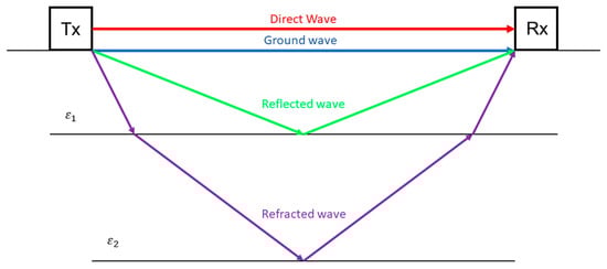
Figure 2.
Propagation of electromagnetic waves in layered media transmitted (Tx) and received (Rx) by ground-penetrating radar equipment. ε signifies the electrical permittivity of the layer.
Understanding how GPR waves interact with the soil and its constituents is crucial for accurate result interpretation. The behaviour of EM waves in the subsurface is governed by several physical principles. Maxwell and Fresnel’s equations describe the reflection and transmission of waves at interfaces between materials with contrasting electric permittivity (ε). The transmission (T) and reflection (R) coefficients at an interface are defined, respectively, as follows:
where and are the permittivities of two different materials in relation to the permittivity of the air. The transmitted part of an EM wave is refracted as it passes from one medium to another, inducing a change of direction. According to Snell’s law, the change is defined by the following:
where and are the incident and refracted angles. The previous equations establish that wave reflection and transmission are entirely dependent on soil electrical permittivity contrasts and wave directionality. The presence of the water table is a typical barrier that reflects the EM waves from further progressing to deeper soil due to the significant permittivity contrast between dry and wet soil [110,111]. As the transmitted EM waves propagate, their change in amplitude (A) is characterized by the following equation [112,113]:
where A is the wave amplitude, α the attenuation factor, σ the electrical conductivity, μ the magnetic permeability, and ω the angular frequency. In agricultural soils, magnetic permeability is generally considered to be unity [23]. In the GPR frequency range (1 MHz to 1 GHz), electrical permittivity is frequency-independent, making the choice of frequency primarily dependent on the desired resolution and penetration depth [114,115]. High frequencies provide a greater resolution but reduced penetration depth, necessitating a balance between these components for the specific agricultural application [108]. In general, drier soils allow for deeper wave penetration because of low electrical permittivity (3–5 F/m), while wet soils, due to the higher electrical permittivity of water (~80 F/m), decrease the penetration depth [116].
Besides reflectivity and attenuation, soil composition also affects the velocity (V) at which EM waves travel; it is defined by the following equation [112,113]:
Due to the difference in electrical permittivity between dry and wet soil, the velocity of the EM wave will also change, with wet soils having lower wave velocities than drier soils. Another important factor affecting EM wave propagation through the soil is electrical conductivity. While it does not influence the directionality of wave travel, it contributes to EM wave attenuation. Under the assumption of low-loss conditions, the previous attenuation factor is simplified to:
The presence of electrically conductive materials attenuates EM waves and reduces the effectiveness of GPR surveys [117,118]. In agricultural soils, clay presence represents a significant challenge, as wave propagation is impaired when clay content exceeds 5% by weight [119]. To optimize GPR applications, particularly in regions with variable soil textures and compositions, a prior assessment of soil conditions is recommended.
As described in (3), higher frequencies result in reduced penetration depths for electromagnetic waves. This inverse relationship requires a balance between resolution and penetration depth, as higher frequencies improve resolution but limit the ability to investigate deeper subsurface features. The frequency range used in GPR also enables the low-loss assumption—commonly referred to as the wave regime—which presumes that the electrical conductivity of the subsurface is significantly lower than the product of the angular frequency and the electrical permittivity (σ ≪ ωε) [120,121]. In these conditions, velocity estimation can be simplified to the following:
where is the speed of light (). This simplification is advantageous when estimating the depths of reflectors, as it relies only on the average electrical permittivity of the overlying medium, provided the travel time of reflected waves is accurately measured.
3.2. Data Visualization
GPR wave signal related to one position in space is typically plotted on a xy-plane in the form of a trace, with the x-axis measuring travel time and the y-axis measuring amplitude. This is illustrated in Figure 3, where different wave reflections can be observed in the trace.

Figure 3.
Ground-penetrating radar trace obtained from a synthetic model based on the typical soil profile seen in Figure 1, including the water table at the C Horizon. D1 is related to the direct wave measurement, and R1, R2, and R3 to the reflections off layers B, C, and R. Exponential gain was applied for the visualization of reflected waves. The simulation was performed using GPRMax (version 3.1, The University of Edinburgh/Northumbria University, Edinburgh/Newcastle, UK) [122].
GPR trace analysis is useful in measuring variations in water content relative to changes in soil permittivity [36,123]. When multiple traces are plotted together vertically, they form a wiggle plot, which can be transformed into a radargram by rotating the traces 90 degrees and color-coding amplitude variations around zero (Figure 4). The radargram is the most used visualization of GPR data acquired along profile lines, providing an image that can be used for preliminary interpretation of subsurface features [23]. Another common way to interpret GPR data is geostatistics, which enables the interpolation of adjacent profile data to create slice maps at different depths. This approach relies on a process called kriging, which can assume different forms—namely, ordinary kriging, block kriging, cokriging, and kriging with external drift—each suited to different contexts. For example, ordinary kriging is applied when interpolating GPR data across an area without additional variables [124,125,126]. When kriging incorporates variables with different supports, kriging with external drift is a more suitable method to be applied [127,128,129].
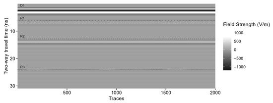
Figure 4.
Radargram obtained from a synthetic model based on the typical soil profile seen in Figure 1, including the water table at the C Horizon. D1 is related to the direct wave measurement, and R1, R2, and R3 to the reflections off layers B, C, and R. Exponential gain was applied for the visualization of reflected waves. The simulation was performed using GPRMax (version 3.1, The University of Edinburgh/Northumbria University, Edinburgh/Newcastle, UK) [122].
Lastly, the frequency spectrum of acquired traces is also a way to interpret data as frequency peaks shift depending on changing soil properties [130], and, more recently, machine learning has also been applied [131,132].
3.3. Data Acquisition
GPR data acquisition equipment typically includes a control unit, a waveform generator, an antenna system, a data logger, and a power unit [133,134]. The control unit allows the user to configure the data acquisition; the waveform generator generates the emitted signal; the antenna system transmits and receives EM waves; the data logger stores the measured signal; the power unit powers the system. GPS systems to track the acquisition are normally attached. The equipment can be contained in a unit or be set separately, depending on the antenna setup. The common-offset antenna setup (COS) is the most used [135,136,137] and normally has a short and fixed distance between the transmitter and receiver. With this setup, the equipment can be assembled in a box that is placed on a trolley or a cart and moved at a constant speed along a profile line while EM waves are emitted and received with the respective emitting and sampling frequencies. GPR units can also be transported by unmanned aerial vehicles (UAVs), improving mobility and reducing labor costs [138].
COS acquisition is optimal for delineating horizontal soil layers in radargrams but requires prior knowledge of the average soil electrical permittivity until the reflector. Otherwise, depth cannot be estimated. In the absence of this information, increasing the distance between the transmitter and receiver in the antenna setup allows for hyperbolic estimation of velocity, from which depth can be estimated [139]. The separation between transmitter and receiver can be achieved in similar steps from one fixed point or by fixing the transmitter and moving the receiver. These methods of separation are called the common midpoint survey (CMP) and wide-angle reflection and refraction (WARR), respectively [140]. In cases where the incidence angle is high and electrical permittivity contrast between soil layers is high, critically refracted and guided waves can be generated. These types of waves can be useful for estimating SWC in the topsoil [141,142,143].
4. Systematic Review Methodology
For this review article, a systematic search of scientific articles was conducted following the Preferred Reporting Items for Systematic Reviews and Meta-Analyses (PRISMA) 2020 guidelines [144]. First, a search was performed on Scopus and Web of Science databases using queries that included terms related to GPR application on agricultural land and soil degradation (Table 1). To minimize bias and ensure a broad spectrum of evidence, the search queries were conducted independently. Both searches were restricted to publications in English, with the final search conducted on 31 December 2024. Due to the low number of directly relevant results, an additional search was performed using Google Scholar and review articles on related topics [23,31,32,36,37,38,39]. The eligibility criteria for selecting publications were based on several factors: the application of GPR in an agricultural context, a focus on agricultural soil characterization, and the inclusion of field experimentation. Only full-text, peer-reviewed articles were considered, while review articles were excluded. To ensure relevance, the selection process was carried out in multiple stages, beginning with title screening, followed by abstract review, and concluding with a full-text analysis to assess the suitability of each publication. Figure 5 presents a flow diagram outlining this filtering process. In the end, 86 publications were considered for review.

Table 1.
Database and search queries.
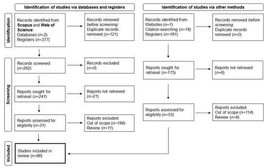
Figure 5.
PRISMA 2020 systematic review flow diagram, outlining the process of article selection and filtering based on relevancy and criteria.
The use of GPR in agricultural soil studies has expanded over the past decades, with applications spanning a wide range of soil properties and conditions. A systematic review of the selected literature indicates that the most investigated soil property using GPR is SWC, followed by soil texture, structure, porosity, root detection, water dynamics, subsurface features, and agrochemical distribution (Figure 6a). The capability of GPR to assess these properties non-invasively makes it a valuable tool for precision agriculture, soil health monitoring, and land management strategies.
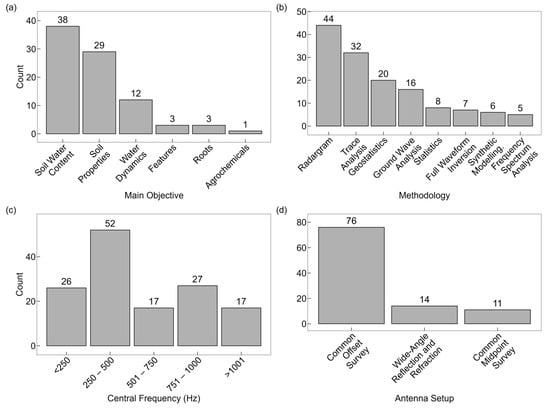
Figure 6.
Ground-penetrating radar applications in agricultural soil research: (a) distribution of study focus; (b) commonly used data processing and interpretation methodologies; (c) frequency ranges applied in agricultural studies; and (d) experimental antenna configurations and setups.
A variety of data processing, analysis, and interpretation methodologies have been employed to extract meaningful information from GPR signals. Among these, radargram imaging is the most widely used technique, providing detailed subsurface profiles that enable soil structure and moisture assessments. Other commonly applied methods include trace analysis and monitoring, geostatistical modelling, ground wave analysis, statistical approaches, full-waveform inversion, synthetic modelling, and frequency spectrum analysis (Figure 6b). These methodologies allow the extraction of both qualitative and quantitative information on soil conditions, improving the precision of agricultural geophysical studies.
Regarding the frequencies used in agricultural GPR research, most studies operate within the 250–500 MHz range, balancing penetration depth and resolution for optimal subsurface characterization. Higher-frequency ranges (501–750 MHz, 751–1000 MHz, and >1001 MHz) are used in studies requiring finer spatial resolution, such as root detection and detailed structural analysis, whereas lower-frequency ranges (<250 MHz) are employed when deeper penetration is needed, such as in water table delineation and large-scale soil heterogeneity assessments (Figure 6c).
Different antenna setups have also been employed based on the study objectives and soil conditions. COS is the most frequently used, offering ease of deployment and high efficiency for agricultural applications. However, WARR and CMP surveys were often conducted to perform velocity analysis for accurate depth estimation of soil layers or ground wave analysis (Figure 6d).
Following this systematic search and selection process, a total of 24 studies were considered directly relevant to the scope of this review article. To provide a structured comparison, Table 2 summarizes the main characteristics of these studies, offering an overview of how GPR was informative in the assessment of soil degradation. This comparison helps to identify research gaps, evaluate the consistency of methodological choices across studies, and highlight the potential for integrating GPR with other geophysical and remote sensing techniques for a more comprehensive soil health evaluation.
Table 2.
Summary of reviewed studies on the application of surface ground-penetrating radar for soil degradation assessment, including the main objectives, central frequencies, methodologies, and main findings of each study pertaining to soil degradation. GPR: ground-penetrating radar; ERT: electrical resistivity tomography; EMI: electromagnetic induction; TDR: Time-domain Reflectometry; SWC: soil water content; SOC: soil organic carbon.
An analysis of the studies reveals that the majority of research publications presenting evidence of soil degradation are concentrated in Europe, followed by Asia and North America, as presented in Figure S1.
5. Applications of Ground-Penetrating Radar in Agricultural Soil
The selected studies are analysed in the following subsections based on their objectives, methodologies, GPR configurations, and main findings related to soil degradation assessment. Given the diversity of approaches employed in previous research, these are categorized according to their primary focus areas: (1) topsoil disintegration, which includes studies that examine GPR’s ability to detect alterations in the uppermost soil layers due to agricultural activities, particularly tillage; (2) soil compaction, which includes research studies on how GPR can identify compacted layers caused by machinery traffic and excessive land use; and (3) other relevant findings, which includes studies that explore additional applications of GPR in soil degradation assessments, such as water flow pathways, organic carbon variability, root systems, and agrochemical distribution.
An analysis of the distribution of studies by type of soil degradation (Figure 7a) and their temporal evolution (Figure 7b) reveals that most research provides evidence of tillage disintegration, followed by soil compaction, with fewer studies focusing on other degradation types. Additionally, there is a tendency for more studies to present indirect evidence of soil degradation than direct evidence. However, in the last five years, there has been an increase in studies with direct evidence, suggesting an interest in using more robust, direct methods to assess soil degradation. To gain a deeper understanding of these trends, statistical measures such as correlation or trend analysis could be applied to quantify the relationship between the types of degradation and the periods in which they were studied.

Figure 7.
Distribution of studies per (a) soil degradation type and (b) temporal evolution of studies with indirect and direct evidence.
5.1. Assessment of Topsoil Disintegration
5.1.1. Standard Approaches
Dominic et al. [145] conducted an early study using GPR radargram imaging to investigate shallow stratigraphy. The study site, located in Ohio, USA, consisted of clay-rich, low-permeability soil, where GPR data acquired with COS and a central frequency of 80 MHz revealed a homogeneous topsoil layer, clearly distinguishable from the subsoil, with a strong reflection interface at 10 ns, attributed to tillage-induced stratification. However, the study reported limited depth penetration due to high clay content, evidenced by preliminary measurements with a central frequency of 300 MHz, which resulted in an attenuation of the GPR signal. The authors suggested that using a dual-antenna configuration instead of a monostatic setup could improve the results, likely by enabling the use of alternative antenna setups such as WARR and CMP, which improves subsurface velocity estimation.
Nobes et al. [150] examined the impact of deep tilling on an agricultural field in Christchurch, New Zealand, which had been affected by an earthquake-induced surface rupture. GPR data acquired with a COS and a central frequency of 100 MHz before and after the tillage intervention showed that tillage lowered topsoil electrical permittivity. The study also tested two transmitting power levels (500 V and 1000 V), noting that while higher power improved signal reflectivity, it also caused clipping of the direct wave, complicating migration and deconvolution processing. The authors recommended optimizing transmitting power and employing stacking techniques to mitigate signal interference. The study also attempted to detect subsurface voids caused by seismic activity, but this objective was not successfully achieved, leading the authors to propose the use of higher central frequencies for future research.
Jonard et al. [151] conducted a comparative study on the effects of different tillage systems on silty loam soil of agricultural land in Gentinnes, Belgium, where the silt fraction dominated the topsoil. The study compared conventional tillage with a mouldboard plough (~27 cm depth), deep loosening tillage (~30 cm depth), and reduced tillage (~10 cm depth). GPR data were acquired using both off-ground and on-ground COS at central frequencies between 0.2 GHz and 2 GHz for surface SWC estimation and 400 MHz for radargram imaging. The analysis of on-ground radargrams showed a distinct layer of lower amplitude associated with the tillage zone of influence. SWC estimations showed that conventionally tilled soil retained less water compared to the other two systems, which indicates that tillage reduces capillary connectivity with deeper soil layers, impeding upward water movement. Variogram analysis also demonstrated that conventional tillage increased SWC variability, likely due to the mixing of compact soil clumps with aerated topsoil, a key factor influencing soil heterogeneity. The study acknowledged biases introduced by using an average dielectric permittivity value for depth estimation and suggested that detailed electrical permittivity profiles would improve depth accuracy estimation. Additionally, the authors stated that 400 MHz was not optimal for resolving finer stratigraphic features, implying that higher frequencies would enhance imaging resolution.
Cavallo et al. [152] studied soil composition variation at the experimental farm in Foggia, Italy, by comparing data from crop yields, namely ERT, EMI, and GPR. The soil at the farm was of alluvial origin and had a silty-clay texture. The GPR data were acquired with a COS and a central frequency of 250 MHz, which were processed through geostatistical techniques, including block kriging, to obtain GPR amplitude maps. These maps identified an area in the southwestern part of the field with higher amplitudes in the 0.1–0.4 m depth range, even though it had higher sand content than in other parts of the field. This depth coincided with the tillage depth range. Below, the amplitude was greatly attenuated due to increasing clay content. Most likely, the clay-rich subsoil contributed to waterlogging, which resulted in higher reflectivity at the topsoil/subsoil boundary. The authors viewed the overall study findings as encouraging but preliminary and required further confirmation over time in different experimental conditions. In the same line as Benedetto et al. [149], it was also stated that the results showed that effective estimation of soil spatial variation cannot be achieved using one sensor only and that a multisensor platform combined with sensor data fusion techniques can provide a comprehensive spatial and temporal soil representation.
5.1.2. Multivariate Characterization
Benedetto et al. [149] applied multivariate kriging with external drift of EMI and GPR data to investigate clay variability at an experimental farm in Bari, Italy. The clay content varied from 30% to 85% in the upper layers and increased with depth. Block kriging interpolation of COS data acquired with central frequencies of 600 MHz and 1600 MHz showed lower reflection amplitudes in the tilled topsoil (<0.35 m) and higher amplitudes at the interface with the subsoil, suggesting that tillage had disrupted natural stratification, as observed in the previous studies (Figure 8). As for the main objective of the study, the authors concluded that due to soil complexity and small datasets and despite the multivariate approach, results were insufficient to fully characterize clay variability at the site but still highlight the need for a multisensory approach to improve soil structural assessments.

Figure 8.
Estimated GPR amplitude for 600 MHz antenna frequency. Adapted from Benedetto et al. [149].
Barca et al. [154] investigated SWC estimation improvements in the topsoil of an experimental farm in Rutigliano-Bari, Italy, using EMI and GPR data by combining statistical and geostatistical techniques, including principal component analysis, linear mixed models, cokriging and kriging with external drift. The soil is clay-rich, with the clay content ranging from 30% to 60% and increasing with depth. The GPR data acquisition was made using a COS with central frequencies of 250, 600, and 1600 MHz. Principal component analysis of the lowest-frequency data identified a signal amplitude reversal at ~0.6 m depth, attributed to the lower boundary of the tillage layer discontinuity, being consistent with the available pedological profile of the site [149]. Comparisons between linear mixed models and the kriging with external drift revealed that the former was unable to find a significant residual spatial structure in comparison with the latter, except when EMI data were included. The authors concluded that kriging with external drift was more appropriate to spatially model SWC, at least in comparable conditions to that of the experiment.
5.1.3. Advanced and Machine Learning Approaches
Kaufmann et al. [158] tested a new multi-offset instrument developed by Sensors & Software (Mississauga, ON, Canada) for WARR and CMP surveys, aiming to reduce labor data acquisition with these antenna setups, and developed a new data processing approach. The test was carried out in a test site in Selhausen, Germany, on loess soil with moderate lateral variability in stone and clay content, using GPR ground wave data with a central frequency of 500 MHz. The electrical permittivity profile of the site delineated the tilled layer as a low-permittivity horizon (Figure 9) despite no major vertical variations in soil texture. The study had no major setback, though direct wave and ground wave interference at greater offsets during summer, particularly in dry datasets, requiring automated semblance filtering to recover valid data.
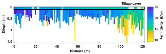
Figure 9.
Electrical permittivity profile. Adapted from Kaufmann et al. [158].
Further advancements in GPR-based SWC estimation were explored in several studies conducted in an experimental agricultural field in Changchun City, China [163,164,167]. These studies assessed, in part, the impact of tillage on topsoil SWC using machine learning, early-time analysis (ETS), and statistical modelling techniques applied to GPR data acquired with a COS at a central frequency of 500 MHz. The soil at the study site was described as black soil rich in organic matter and clay, overlaying loess material, providing a highly structured medium for evaluating the effects of tillage on SWC.
Li et al. [164] applied a convolutional neural networks (CNNs) framework, named GPRSW, to extract SWC information from GPR data. The results indicated that the tilled portion of the field consistently showed lower SWC than the non-tilled portion, as observed in radargrams and predicted SWC (Figure 10). The authors attributed this finding to the loosening of soil structure and increased exposure to air, which lowered electrical permittivity and reflectivity, a trend consistent with previous studies.
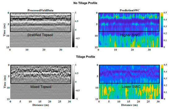
Figure 10.
Radargram imaging and SWC prediction. Adapted from Li et al. [164].
Lu et al. [163] investigated the influence of both electrical permittivity and conductivity on GPR’s ETS average envelope amplitude and its relation to SWC. Results demonstrated that the tilled area of the field had higher soil heterogeneity than the no-tillage area, with the latter having higher SWC than the former. Furthermore, electrical permittivity was the dominant factor influencing ETS, leading the authors to prioritize this parameter in their SWC estimation models while minimizing the impact of electrical conductivity variations. The authors highlight that the soil heterogeneity affected SWC estimations but stated that the results remained comparable to those obtained using TDR and direct soil moisture measurements at the study site, suggesting that the chosen methodology can be used to measure SWC in heterogeneous soils.
Zhou et al. [167] explored multi-feature ensemble learning based on Adaboost R to improve the predictive accuracy of GPR-derived SWC estimates. Results showed SWC differed significantly in the no-tillage and tilled areas of the field. The study highlighted a critical challenge in machine learning applications for soil property estimation: the trade-off between feature selection and model generalization. Furthermore, the authors found that both an excessive number of extracted features and an overly limited feature set negatively impacted model performance. Moreover, the best predictive results were not solely dependent on the error minimization of individual features but rather on the combined contribution and interaction among different GPR-derived parameters. Consequently, they emphasized that feature selection in GPR-based SWC prediction must be optimized beyond individual feature accuracy, incorporating a more holistic approach to feature interaction modelling.
Li et al. [164] and Zhou et al. [167] demonstrated the growing role of machine learning and computational modelling in advancing GPR-based soil moisture assessments, particularly in heterogeneous agricultural landscapes. However, the authors acknowledged that further validation is needed across different soil types, climatic conditions, and cropping systems to fully leverage data-driven GPR interpretations for large-scale SWC monitoring.
5.2. Assessment of Soil Compaction
Several studies have demonstrated the capability of GPR to detect soil compaction caused by heavy agricultural machinery, highlighting its role in assessing subsurface structural modifications and their implications for soil moisture retention, root growth, and overall soil health.
5.2.1. Identification and Monitoring
Wollschläger and Roth [147] investigated the temporal variations in SWC within compacted layers on farmland near Heidelberg, Germany, using GPR trace monitoring and analysis. The soil was classified as sandy loam with increasing clay content with depth, and long-term agricultural activity led to the formation of a plough pan in the subsoil. Continuous GPR measurements with a central frequency of 250 MHz conducted throughout 2004 successfully detected two distinct reflections attributed to the upper and lower boundaries of a compacted layer, located at 0.8 m and 1.65 m depth, respectively. The reflections showed variations in travel time due to seasonal fluctuations in SWC, but the time between the first and the second remained stable, indicating low SWC variability within the compacted layer (Figure 11). However, the authors acknowledged that SWC estimation might have been overestimated due to uncertainties in precise depth calibration related to the varying perched water table depth during the experiment.
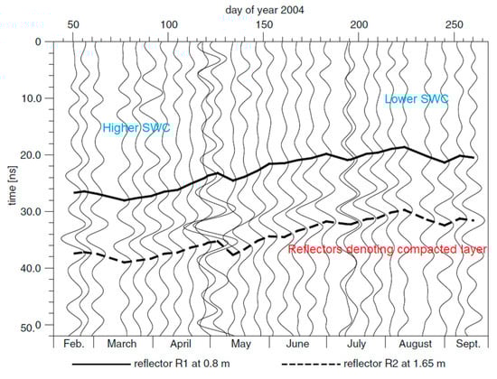
Figure 11.
Trace analysis example. Adapted from Wollschläger and Roth [147].
André et al. [148] conducted a study in a vineyard in Bordeaux, France, with a soil characterized by sand over clay, gravelly–sandy soil, and sandy soil with pseudogley. Using COS GPR data with a central frequency of 400 MHz for radargram imaging, the authors identified a strong and continuous reflection at a shallow depth, confirmed through soil pits as compacted zones resulting from machinery traffic under wet conditions (Figure 12). These zones were associated with lower grapevine vigour, likely due to reduced root development and waterlogging conditions within the root zone. No significant limitations regarding GPR data acquisition and interpretation were reported, suggesting that GPR was effective in detecting soil compaction in this specific vineyard.
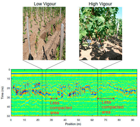
Figure 12.
Radargram and plant vigour associations. Adapted from André et al. [148].
Castrignanò et al. [153] analysed soil variability and structural changes in an experimental agricultural field in the Sarno Plain, Italy, using block cokriging of multisensory data, namely of EMI and GPR. The sandy to silty loam soil, with high carbonate content, was intensively managed for tomato cultivation. The individual GPR data, collected with a COS and a central frequency of 250 MHz, were processed to produce block-kriged amplitude maps, which revealed a clear transition at approximately 0.4 m depth, particularly in the central and northeastern parts of the field. This transition was likely due to long-term agronomic practices aimed at optimizing soil conditions for crop production. While no major limitations were reported, the authors highlighted the challenges of data fusion methodologies for soil characterization, suggesting the development of new and more powerful techniques to address changes in soil structure.
5.2.2. Waterlogging
Benedetto et al. [155] and Benedetto et al. [169] investigated SWC at an experimental farm in Metaponto, Italy, through the cokriging of gravimetric, EMI, and GPR data. The study site was characterized by poor drainage and a silt-to-clay soil texture. GPR amplitude maps, obtained through ordinary kriging of COS data acquired with a central frequency of 600 MHz, identified a localized area with higher reflection amplitudes at 0.3 m depth potentially caused by waterlogging by soil compaction. Diacono et al. [170] underscore that past agricultural practices at the site included surface tillage and ridge system cultivation, which may have contributed to subsurface heterogeneities, including compaction. The studies faced velocity analysis challenges, as hyperbolic reflections were absent from radargrams, needing the use of assumed average values for velocity estimation. Additionally, comparisons between 600 MHz and 1600 MHz datasets revealed inconsistencies, likely due to soil heterogeneity affecting high-frequency signal penetration. The authors concluded that the methodologies were reasonably successful for SWC estimation in highly variable soil conditions and referred to the importance of using multiple sensors, different GPR frequencies, and prior soil characterization in SWC studies.
Cao et al. [157] studied volumetric SWC in orchards in Yingtan, China, characterized by silty loam soil. In this study, the authors used ground wave information and ordinary kriging of GPR data acquired with a CMP setup and a COS with a central frequency of 60 MHz. Through well-fitted petrophysical relationships between SWC and dielectric constants, results demonstrated that water consistently accumulated at 0.2–0.4 m depth after rainfall events, indicating the presence of a compacted layer that impeded infiltration and led to waterlogging. This was visible as well in the SWC interpolated maps, particularly in the lower elevation areas. For the estimation of the dielectric constants, from which SWC values were derived, the authors assumed a constant EM wave velocity for the considered depth range of 1 m, which limited the use of the established petrophysical relationships to other soils. Additional challenges included higher estimation errors when SWC levels were elevated due to increased electrical conductivity in clay-rich portions of the study area. Surface roughness from recent tillage operations also interfered with GPR signal propagation, reducing SWC estimation accuracy in the 0–0.2 m depth range.
5.2.3. Soil Surface
Akinsunmade et al. [156], Akinsunmade et al. [159], Akinsunmade et al. [160], and Kiełbasa et al. [161] conducted a series of studies on the impact of repeated tractor traffic on farmland in Kraków, Poland, with sandy to silty loam soils, using different methodologies, such as radargram imaging, trace analysis, and frequency spectrum analysis of COS GPR data acquired with a central frequency of 800 MHz. The results revealed that repeated tractor passes caused signal attenuation at tire paths, which manifested as lower power and peak shifts in frequency power spectra (Figure 13). The authors attributed these findings to pore structure collapse and water removal from compacted areas. No major limitations were reported in their experiments.
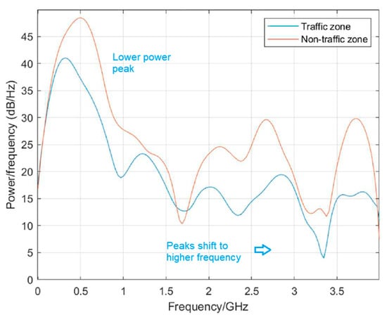
Figure 13.
Power spectral density analysis. Adapted from Akinsunmade et al. [159].
Lastly, Pathirana et al. [168] investigated topsoil compaction effects using a lawn roller at a previously tilled experimental field in Pasadena, Canada, which has loamy soil. GPR data were acquired in a CMP setup and a central frequency of 500 MHz to obtain ground wave information, which was then analysed using descriptive statistics, machine learning, and predictive modelling for bulk density estimation. One-way ANOVA results demonstrated that four roller passes increased both bulk density and electrical permittivity, with additional passes decreasing their effect. According to random forest variable selection, electrical permittivity had a stronger predictive power for compaction than ground wave amplitude. Furthermore, regression models incorporating both electrical permittivity and conductivity yielded high prediction accuracy for soil bulk density, which the authors attributed to the reduction in air space and increased connectivity between soil constituents, including organic carbon, moisture, and minerals. However, the study acknowledged that the low SWC variability in the site may have positively influenced prediction accuracy. Given that SWC is the primary driver of electrical permittivity and conductivity variations in agricultural soils, the authors suggested that in soils with higher and more variable SWC, the correlation between bulk density and GPR-derived electrical properties might be less pronounced.
5.3. Additional Findings
This section presents additional GPR-based findings relevant to soil degradation that do not fit directly into the categories of topsoil disintegration or compaction but still provide interesting results into soil processes influenced by agricultural practices. The reviewed studies in this section focus on water movement and erosion risk, SOC variability, root system adaptation to tillage, and soil composition influenced by agricultural management.
Huisman et al. [146] studied the spatial variations in SWC induced by irrigation patterns in a pasture with sandy loam soil in Molenschot, The Netherlands. The study evaluated how different irrigation strategies and application methods influenced soil water distribution. Differential SWC maps, derived from geostatistical GPR universally kriged GPR ground wave data, collected with a COS and a central frequency of 225 MHz, successfully distinguished different irrigation patterns, revealing preferential flow paths that promoted lateral water movement. In cases where intensive, concentrated irrigation was applied to a single area, GPR detected potentially problematic runoff and soil erosion risks, as excess water created lateral flow pathways (Figure 14). However, the authors noted that small-scale variations in SWC were averaged out due to the inherent sampling volume of GPR measurements, and the unknown depth range of the ground wave posed challenges for precise water distribution estimation. Furthermore, the individual trace analysis to calculate the refractive index used an average time of arrival for the direct wave due to interference issues in the measurement process. Lastly, it was proposed to perform GPR measurements, including crossing transects, to analyse potential correlated measurement errors on the short-range structure of the GPR variogram, even though calculated short-range and long-range semi-variances aligned well. These findings highlight the importance of experimental design, and GPR signal penetration depth considerations when using the technique for hydrological and erosion studies.
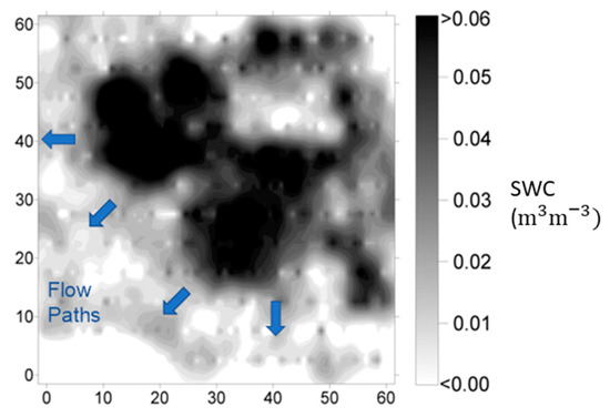
Figure 14.
Difference in SWC in the soil after irrigation. Adapted from Huisman et al. [146].
Benedetto et al. [162] explored the potential of GPR for predicting SOC variability in an olive grove with loam soil in Fasano, Italy, through multivariate adaptive regression splines (MARS) and regression kriging (RK) modelling. GPR-derived covariates, obtained from COS data with a central frequency of 600 MHz, were highly correlated with SOC distribution, demonstrating the ability of GPR to detect SOC variability in agricultural soils. Although the study did not attribute SOC fluctuations to specific agricultural mismanagement practices, it highlighted GPR’s sensitivity to potential degradation factors influencing SOC content (Figure 15). The authors found that MARS outperformed RK, as it was better at capturing nonlinear interactions between multiple soil variables. MARS also provided piecewise linear splines with variable gradients, allowing for higher adaptability in heterogeneous soils. However, the authors reported that the results might be site-specific, requiring further testing across different soil types and agricultural settings to establish a broader applicability for GPR-based SOC monitoring.
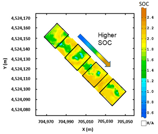
Figure 15.
Soil organic carbon mapping with multivariate adaptive regression splines. Adapted from Benedetto et al. [162].
Hugenschmidt and Kay [166] assessed the influence of tillage on the root distribution of trees adjacent to an agricultural field with sandy loam soil in Zürich Canton, Switzerland, using radargram imaging from COS data with a central frequency of 400 MHz. The study compared root structures in no-tillage and tilled zones, revealing that tillage significantly disrupted shallow root systems (<0.4 m depth), forcing trees to develop deeper roots to compensate for lost structures (Figure 16). However, the authors report that GPR could only detect roots with a minimum diameter of 1 cm, limiting the study’s ability to assess finer root networks. Additionally, vertical roots were difficult to detect, as their perpendicular orientation to the soil surface reduced their cross-sectional area in radargrams, making them less distinguishable from background noise. The small sample size (only two trees in the same environment) was another limitation, as root development is influenced by multiple factors, including climate, soil type, water availability, and species-specific adaptations. The authors recommended larger-scale investigations to confirm whether GPR can reliably track tillage-induced changes in root systems across different tree species and agricultural settings.
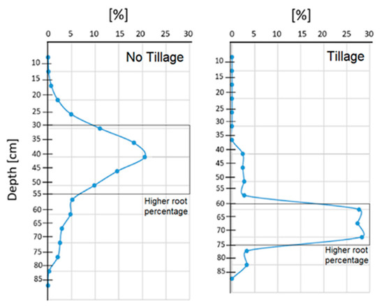
Figure 16.
Root percentage at depth of trees in no-tillage and tillage soil from Hugenschmidt and Kay [166].
Ruan et al. [165] examined GPR’s ability to differentiate soil stratification and composition in two farms in Shuangyashan and Jiamusi, China, using wavelet and frequency envelope analysis of GPR data acquired at central frequencies of 100, 250, and 500 MHz. Both farms underwent routine tillage to 0.40 m depth and harrowing to 0.16 m depth. Although the study did not explicitly analyse the impact of agricultural management on soil stratification, it found that one of the investigated soils exhibited significantly higher electrical conductivity and magnetic permeability due to elevated iron oxide content, which hindered GPR signal penetration and resolution. This soil also underwent fertilization, which may have further increased electrical conductivity, complicating GPR-based stratigraphy assessments. GPR surveys had to be conducted outside the plant growth period (October) to avoid signal interference from vegetation. Additionally, wavelet analysis was found to have low-frequency resolution, reducing its effectiveness in detecting thinly stratified soil layers. These findings highlight the importance of selecting appropriate GPR frequencies for soil stratigraphy studies, particularly in soils with high mineral content or subject to fertilization-induced conductivity changes.
6. Discussion
Conventional agricultural management typically involves mechanized tillage and fertilization operations, as discussed in Section 2, which contribute to soil degradation by altering its structure, reducing biological activity, and compacting pore networks essential for water and nutrient circulation [75,84,85]. The review of GPR studies has demonstrated that these changes are detectable and quantifiable using EM wave propagation analysis, particularly for assessing topsoil disintegration and soil compaction. Other important results, including preferential water flow, SOC variability, root system adaptation, and soil composition, further illustrate the potential of GPR as a non-invasive diagnostic tool for soil health monitoring.
6.1. Topsoil Disintegration
The reviewed studies (Section 5.1) indicate that tillage alters soil reflectivity and electrical permittivity, mainly due to the destruction of natural layering, increased exposure to air, and loss of SWC. These findings align with previous non-geophysical studies on tillage-induced soil degradation [68,171,172]. Additionally, evidence suggests that tillage disrupts vertical connectivity with deeper soil layers, promoting waterlogging, a process that can reduce crop yields by up to 20% globally [64,68,173,174]. This effect was evident in clay-rich soils, which are prone to water retention due to their fine texture and low permeability [175,176]. In other soil types that varied between sandy loam and silty loam, similar problems are not as serious in principle. Furthermore, despite clay’s high attenuation of electromagnetic waves [119,177], GPR studies focusing on the first meter of soil depth were still able to extract meaningful conclusions. Soil heterogeneity was often identified as a limitation factor, as soil texture can vary in sand, silt, and clay content depending on location. This variability affects the impact of topsoil disintegration due to tillage, making the extent of degradation related to this practice site-specific.
6.2. Soil Compaction
The reviewed studies (Section 5.2) demonstrate that soil compaction causes an impact on GPR signal propagation, primarily by increasing wave reflectivity due to higher bulk density and reduced pore space. As bulk density increases, electrical permittivity rises, leading to stronger reflections and reduced signal penetration [178]. André et al. [148] observed that soil compaction negatively affected vine vigour, likely due to restricted root development and impaired respiration, further reinforcing the detrimental effects of compaction on plant growth and productivity. Similar results have been reported in studies examining the impact of soil compaction on root development, which indicate that restricted root access to nutrients and oxygen significantly impairs plant health [179,180,181].
While soil compaction naturally occurs with depth due to overburden pressure, mechanized agriculture aggravates this process, leading to conditions that delay plant root expansion, water infiltration, and nutrient uptake to agriculture and, thus, affect plant health [182,183,184]. The severity of compaction is strongly influenced by soil texture, with clay-rich soils being particularly susceptible, especially under wet conditions. These soils show a high plasticity and low permeability, making them prone to water retention and prolonged structural deformation when subjected to external loads.
It has been reported that clay-rich soils can take up to 11 years to recover from compaction without human intervention [85,185]. Among the reviewed studies, only two explicitly reported compaction in clay-rich soils, where it was identified as the primary cause of waterlogging [155,169]. However, the unclear origin of the compaction made it difficult to link it to past land management practices or natural consolidation. Regardless, the studies confirmed that tillage-induced structural differences between topsoil and subsoil contribute to waterlogging, a problem further exacerbated by heavy machinery traffic.
The remaining studies focused on sandy loam and silty loam soils, which, despite their coarser texture and better drainage capacity, were still affected by compaction. This indicates that compaction is a widespread issue in agricultural soils, with the severity of its impact increasing with clay content [176,186].
6.3. Other Applications
Beyond topsoil disintegration and compaction, four studies have demonstrated that GPR can be used to assess additional aspects of soil degradation that are relevant to agricultural sustainability and productivity. These include soil erosion through preferential water flow, SOC variability, root system disruptions caused by tillage, and the impact of high iron oxide content on soil conductivity and fertility.
One of the findings was the ability of GPR to detect preferential water flow paths caused by intense irrigation, a phenomenon that can lead to soil nutrient depletion, erosion, and spatial variability in plant vigour [102,187]. Huisman et al. [146] mapped water redistribution patterns using differential SWC maps derived from geostatistical GPR kriged amplitude data, revealing that focused irrigation application could create lateral water movement, potentially increasing the risk of erosion and leading to uneven nutrient distribution within the field. These results suggest that GPR could be used as an early detection tool for identifying erosion-prone zones, potentially helping farmers optimize irrigation strategies to minimize soil degradation.
Another important aspect of soil degradation identified through GPR studies is the destruction of plant and tree root systems caused by tillage. While tillage is primarily used to prepare soil for planting and manage weeds, it can also physically damage roots, forcing plants and trees to develop deeper root systems as an adaptation mechanism [188,189]. Hugenschmidt and Kay [166] successfully detected root displacement in trees adjacent to tilled agricultural fields, showing that roots were almost absent in the tilled layer but had compensated by extending deeper into the subsoil. These results highlight the long-term impact of tillage on plant root architecture, with potential consequences for water uptake, nutrient absorption, and overall tree health. However, root detection efficiency using GPR is highly dependent on central frequency, as smaller root structures remain undetectable at lower frequencies. Future studies should explore multi-frequency GPR approaches to improve the accuracy of root mapping in different soil conditions.
Another challenge identified in the reviewed studies is the influence of high iron oxide content on GPR signal propagation. Ruan et al. [165] found that soils with high iron oxide concentrations exhibited higher electrical conductivity, leading to strong attenuation of the GPR signal. This presents a major limitation for GPR-based assessments of soil structure and fertility in regions where iron oxides are naturally abundant.
Iron oxide is known to interact with fertilizers by adsorbing essential nutrients, potentially contributing to soil acidification over time [190,191]. Consequently, GPR could serve as a preliminary assessment tool to evaluate soil in regard to its EM attenuation, provided SWC is not too high, allowing for the potential identification of iron-rich soils before implementing fertilization programs. While multiple GPR methodologies could theoretically be applied for this purpose, point-based trace analysis would likely be the most efficient approach, as it would allow for quick assessments without the need for extensive field surveys.
6.4. Methodological Approaches
The methodologies used to assess compaction align with those used for topsoil disintegration. Radargram imaging was effective in both detecting topsoil disintegration and compacted soil layers, as demonstrated, for example, in Nobes et al. [150] and André et al. [148], where the effect of tillage and compaction was visible. Due to its standardized application in GPR studies and quick result generation, radargram imaging remains a valid approach for providing farmers with important information on their land parcels.
In this context, trace analysis emerged as a useful alternative to radargram imaging for detecting localized compaction, which is often confined to specific areas of a field rather than occurring uniformly. As shown by Wollschläger and Roth [147], simple point-based GPR measurements can be sufficient to detect compacted layers and assess their seasonal stability. Given that compaction tends to be site-specific rather than uniform across entire fields, targeted GPR surveys could serve as an efficient method for identifying areas that need to be addressed for localized soil management interventions.
While geostatistical methods offer a more detailed spatial analysis of soil properties, they require extensive data collection and computational processing, making them less practical for real-time agricultural applications. Nevertheless, for large-scale assessments of soil heterogeneity and compaction trends, geostatistics can provide information for long-term soil monitoring and land-use planning.
Lastly, ground wave analysis was shown to be effective in near-surface soil characterization and SWC estimation [157,158]. However, it generally requires more laborious acquisition with CMP or WARR setups for effective separation from the direct wave, which in dry soil can be difficult and require advanced processing [23,158]. If conducted with a COS, the separation from transmitter to receiver must be wide enough to separate the two waves. Otherwise, it is unfeasible, especially in dry soil [28,192]. Table 3 offers an overview of the main methodologies used in the reviewed studies. Other methodologies, such as statistical modelling, machine learning, and average envelope amplitude estimation, are less intuitive for field application, making them better suited for supplementary data processing rather than primary soil diagnostics.
Table 3.
Comparison of the main ground-penetrating radar (GPR) methodologies used in soil degradation assessments, highlighting their respective strengths and limitations in practical field applications. SWC: soil water content.
Further integration of these methodologies could be a future challenge, particularly in developing comprehensive soil management strategies that incorporate traditional radargram surveys. Regardless of the chosen methodology, the reviewed studies highlight the practical application of GPR as a field-based diagnostic tool for farmers, allowing for the assessment of soil conditions for decision support in soil management activities.
6.5. Experimental Approaches
The analysis of experimental approaches for data acquisition and interpretation in the reviewed studies highlights methodological trends and challenges in the application of GPR for agricultural soil research. The analysis of experimental approaches for data acquisition and interpretation in the reviewed studies highlights methodological trends and challenges in the application of GPR for agricultural soil research. In general, the GPR equipment was ground-based, meaning it was in close contact with the ground. This has been the standard practice since it allows for higher penetration of the emitted signal [193], with less noise from external reflectors or signals [194]. However, the ground surface should be relatively flat along the acquisition paths to avoid decoupling effects due to surface roughness, which can negatively impact data by causing constant shifts in antenna orientation [195]. A recent solution is UAV-based GPR acquisition, which can efficiently and quickly scan an area, provided the weather is favorable [138,195,196,197]. It should be noted that this solution can only accommodate COS data acquisition, which limits its scope.
The choice of antenna configuration, as well as the selection of central frequencies, plays an important role in data quality, interpretation accuracy, and overall feasibility for field applications. For example, lower frequencies are better for deeper penetration, while higher frequencies provide greater resolution for detecting finer soil features. These factors are critical in choosing the appropriate equipment for specific field conditions and are now discussed.
6.5.1. Antenna Setups
The COS was the most frequently used antenna setup for GPR data acquisition (Figure 6d), primarily due to its ease of deployment, reduced labor requirements, and minimal wave refraction issues in layered environments such as agricultural soils. The COS enables rapid scanning, making it an efficient method for identifying soil disturbances related to tillage, compaction, and water movement.
However, a common limitation of COS surveys is the lack of prior information on soil electrical properties, which is essential for accurate depth estimation and material characterization. In such cases, CMP and WARR surveys are often conducted to estimate velocity profiles using hyperbolic curve fitting [198,199]. Although this can be achieved with a COS, the data require hyperbolic from structures such as rocks or pipes, which are not always present. In contrast, the WARR and CMP setups provide hyperbolic signatures linked to soil layers, reducing the risk of misinterpretation due to assumed velocity values.
Beyond velocity analysis, CMP and WARR data were also used for ground wave analysis [158], enabling lateral soil property estimation at depths of up to 0.85 m, depending on the chosen frequency [23]. This highlights the potential of multi-offset approaches for capturing broader subsurface variations, particularly in heterogeneous soils, where COS scans may be insufficient due to a small offset between transmitter and receiver. However, these setups require more labor and longer acquisition times, making them less practical for rapid field assessments. Kaufmann et al. [158] reported efforts to develop a new processing approach for multi-offset equipment aimed at reducing the labor-intensive nature of CMP and WARR acquisitions, which could improve the feasibility of these methods for agricultural applications.
Table 4 presents a comparative overview of the different antenna setups used in GPR for soil degradation studies. It synthesizes the strengths and limitations of each antenna configuration, providing insights into their applicability based on soil conditions and research objectives.
Table 4.
Comparison of the main antenna setups used in GPR for soil degradation assessments, outlining their respective advantages and limitations in field applications.
6.5.2. Central Frequency Selection and Trade-Offs
The choice of central frequency significantly impacts spatial resolution and penetration depth, influencing the type of information that can be extracted from GPR surveys. The reviewed studies predominantly used frequencies below 500 MHz (Figure 6c), as these offer a balance between resolution and depth range, allowing researchers to capture meaningful data on soil properties at depths relevant to agricultural management, such as the water table and root zones.
However, in some cases, authors later acknowledged that their frequency selection was not always optimal for their study objectives. For example, studies requiring detailed stratigraphic delineation or precise root mapping found that lower frequencies resulted in insufficient resolution to define finer structures [151,166]. This underscores the importance of careful planning before conducting GPR surveys, ensuring that selected frequencies align with the specific study goals.
Additionally, in highly conductive soils, such as clay-rich or iron-oxide-rich soils, lower frequencies were necessary to compensate for increased attenuation, yet they still faced challenges in signal penetration and resolution loss [152,165]. Future research should explore optimized frequency ranges that provide improved resolution while mitigating attenuation effects, particularly in soils with variable mineral compositions.
Table 5 synthesizes the strengths and limitations of different central frequencies used in GPR for soil degradation assessments by comparing how each frequency range balances penetration depth and resolution, helping to determine the most suitable frequency for different soil conditions and degradation processes.
Table 5.
Synthesis of the main strengths and limitations of different central frequencies used in GPR for soil degradation studies, demonstrating their suitability for various depths and types of soil features.
6.6. Integration of GPR with Other Geophysical and Laboratory Methods
While GPR has proven to be an effective tool for detecting structural and moisture-related soil degradation, its performance can be improved when used alongside other geophysical techniques. Table 6 provides an overview of these four geophysical techniques, highlighting their strengths and limitations in soil degradation assessment.
Table 6.
Comparison of geophysical methods for soil degradation assessment. GPR: ground-penetrating radar; ERT: electrical resistivity tomography; EMI: electromagnetic induction; TDR: time-domain reflectometry.
Several studies refer to the importance of integrating GPR with complementary geophysical and soil sampling techniques to obtain a comprehensive understanding of soil conditions. In total, from the referenced studies, 17 used a multisensory approach for soil characterization, demonstrating that joint use of geophysical sensors is an established practice driven by the need for complementary data to adequately characterize soils. The EMI method was frequently used alongside GPR or in a multivariate approach to provide additional insights into soil electrical properties, water retention capacity, and stratigraphy. Thus, the systematic integration of multiple geophysical methods is strongly recommended whenever possible. At a minimum, cross-validation of GPR data with soil sampling should be conducted to ensure measurement accuracy and minimize misinterpretations due to site-specific soil heterogeneity.
6.7. Future Challenges
The systematic review of GPR applications in agricultural soil research has revealed several areas that remain underexplored, particularly concerning soil degradation processes caused by intensive farming practices. While topsoil disintegration and compaction have been well-documented using GPR, other major degradation mechanisms, such as soil acidification, salinization, and nutrient depletion due to land overuse, excessive fertilization, and irrigation mismanagement, have received limited attention in the reviewed studies. Given that these mechanisms alter soil electrical properties, there is a strong potential for GPR to contribute to their detection and monitoring [158,200,201,202].
One possible research direction is the use of GPR to assess the long-term effects of fertilizer application on soil properties. Excessive fertilization, particularly with nitrogen- and phosphorus-based compounds, can contribute to soil acidification, reducing microbial diversity and plant nutrient availability. Since changes in soil chemistry influence electrical permittivity, ground wave analysis could be used to evaluate how GPR signal reception is affected by increasing fertilizer concentrations over time. Similarly, geostatistical techniques could help map spatial variations in organic matter content, which may fluctuate due to intensive monoculture farming or non-uniform irrigation patterns.
Another critical area where GPR data could contribute is salinization, a process aggravated by poor irrigation management [104] and high evaporation rates in arid regions [203]. Since saline soils show high electrical conductivity, GPR signal attenuation patterns could potentially be correlated with salinity levels, allowing for early detection and mitigation strategies. Radargram imaging could also be used to monitor changes in the depth range of GPR signals in salinized soils, providing a baseline for assessing the effectiveness of soil reclamation efforts.
Lastly, an emerging development is the integration of GPR with unmanned aerial systems for precision agriculture, which has demonstrated the feasibility of acquiring GPR data with higher spatial precision, faster data acquisition, and reduced interference from surface roughness [29,138,195,196,204,205]. While ground-based GPR remains the standard for soil studies, UAV-based systems could improve large-scale soil monitoring by enabling high-resolution mapping of degradation processes across extensive agricultural landscapes. Future research should focus on comparing UAV-GPR data with traditional ground-based surveys to determine the reliability and scalability of aerial GPR for soil degradation studies.
6.7.1. Enhancing Reproducibility
The challenges identified in the reviewed studies, particularly those conducted in the last five years, highlight the need for further methodological refinement and broader validation across diverse soil conditions. Kiełbasa et al. [161] demonstrated that GPR showed a similar performance to force resistance tools for evaluating soil compaction, suggesting that a standardized parametric relationship between these methods could improve their joint application.
Hugenschmidt and Kay [166] mapped tree root systems adjacent to tilled fields and successfully used GPR to determine how tillage affects root growth patterns. However, the authors noted potential limitations in result transferability due to the small sample size and the unique environmental conditions of the study site. Future research should focus on expanding similar studies across different tree species, soil types, and climatic conditions to establish whether root adaptation to tillage-induced damage follows similar patterns in various agricultural settings. Additionally, the authors recommended applying GPR techniques originally developed for drainage pipe detection to long-term monitoring of below-ground biomass and soil carbon storage, a research avenue that could significantly enhance our understanding of carbon sequestration in agricultural soils.
Lu et al. [163] denote the importance of integrating geostatistical modelling with stochastic medium analysis to improve soil heterogeneity estimation. However, further validation is needed across different soil types to confirm the robustness of this approach in varied agricultural conditions.
Similarly, Benedetto et al. [162] and Pathirana et al. [168] demonstrated that GPR can be a reliable tool for assessing SOC variability and surface compaction, respectively. However, both studies acknowledged that their findings may be soil-type specific, necessitating further research in other soil environments to determine whether these methods can be universally applied.
6.7.2. Future Research Directions and Standardization Needs
Although this review highlights the importance of GPR in assessing soil degradation, several methodological challenges remain and require further investigation. Future research should focus on three main areas: (1) improvements in data processing techniques to mitigate signal losses in clay-rich and saline soils; (2) increases in the efficiency of predictive models by incorporating machine learning and multisensor fusion; and (3) development of standardized protocols for GPR surveys in agricultural settings.
Machine learning techniques have demonstrated potential for automating the interpretation of GPR data and improving the classification of soil features [167,168]. Similarly, the integration of GPR in UAVs could enable large-scale soil degradation monitoring with improved efficiency [29,138,195,196,204,205].
Standardization efforts are also critical, particularly in defining optimal frequency ranges and survey methodologies for different soil types, ensuring consistency and comparability across studies. Addressing these challenges will improve the accuracy, reliability, and applicability of GPR in precision agriculture and soil conservation, reinforcing its role in sustainable land management strategies.
6.7.3. Limitations of the Review
This review examined nearly one hundred studies focusing on the application of GPR and other geophysical methods for characterizing agricultural soils. However, one of the primary limitations encountered was the lack of direct research studies into soil degradation processes. While many studies provided information about soil properties such as SWC, compaction, root dynamics, and organic matter distribution, only a limited number explicitly focused on degradation phenomena. Most studies addressed degradation indirectly, making it challenging to compile a comprehensive geophysical perspective on soil degradation.
The scarcity of studies explicitly targeting soil degradation suggests that GPR applications in agricultural research remain underutilized for this purpose. Given the growing global concerns over land degradation, declining soil health, and the impact of intensive agricultural practices on long-term productivity, there is a pressing need for more research focused on how GPR can contribute to soil conservation and sustainable land management strategies. There is, nevertheless, a changing trend in the last five years that might suggest a recognition of this worldwide issue and a proactive effort to assess it with GPR (Figure 7b).
Another issue with the studies is that many prioritize soil characterization for immediate agronomic applications, such as irrigation management, crop yield prediction, and soil structural analysis, rather than long-term monitoring of degradation processes. Soil degradation is often a gradual phenomenon, requiring longitudinal studies and multi-year monitoring. Thus, it requires monitoring over time. This may not align with the objectives of short-term field experiments or one-time geophysical surveys, but it would be important to see a bigger effort in this direction in the future.
Another limitation is the variability in study methodologies and experimental approaches. The studies employed a wide range of central frequencies, antenna setups, and data processing and interpretation techniques, making it difficult to directly compare findings or establish standardized protocols for assessing soil degradation using GPR. Additionally, many studies integrated GPR with other geophysical methods, which contributed to the complexity of the comparisons. On the other hand, the observed variability in experimental approaches and methodologies shows the versatility of GPR in assessing soil degradation, which offers future research that already has much evidence of what could be more appropriate in different scenarios.
To overcome these limitations, future research should focus on explicitly investigating soil degradation processes by designing studies that directly evaluate GPR’s effectiveness in detecting degradation factors such as soil acidification, salinization, nutrient depletion, and erosion. Conduct long-term monitoring campaigns to assess how GPR signals evolve in response to progressive soil degradation rather than focusing solely on static, one-time field measurements; develop standardized methodologies for GPR-based soil degradation assessments, ensuring that studies employ consistent data acquisition protocols, frequency ranges, and processing techniques to enable meaningful comparisons across different soil types and agricultural environments; encourage multisensory integration, where GPR is systematically combined with techniques such as ERT, EMI, TDR, and soil sampling, would improve the reliability of degradation assessments; increase research efforts on how emerging technologies, such as UAV-mounted GPR, could be used to monitor large-scale soil degradation patterns over time would also be beneficial.
Given that soil degradation is one of the most critical challenges facing global agriculture, shifting research priorities towards using geophysical sensors as tools for assessing, preventing, and mitigating degradation could prove to be useful for farmers, agronomists, and policymakers. Expanding this research area would improve the contribution to better decision support for sustainable soil management, ultimately helping to preserve soil health and agricultural productivity for future generations.
7. Conclusions
This systematic review addressed the application of GPR in agricultural research, with a specific focus on its utility for assessing soil degradation processes. A total of 86 peer-reviewed studies were evaluated, of which 24 presented relevant information on soil degradation. The analysis identified topsoil disintegration and soil compaction as the two major soil degradation mechanisms assessed using GPR, demonstrating its value as a non-invasive tool for detecting, monitoring, and characterizing soil degradation processes caused by agricultural activities. However, research gaps remain, particularly in evaluating broader degradation processes such as erosion, salinization, and nutrient depletion.
The results from the reviewed studies showed that GPR could detect tillage-induced disruptions in topsoil structure, revealing how the loss of natural layering increases aeration, reduces water retention and heightens waterlogging susceptibility. Additionally, GPR allows for the identification of soil compaction from agricultural machinery, as compacted layers showed higher electromagnetic reflectivity, reduced pore space, and stable soil water content.
Beyond these primary findings, GPR can provide valuable insights in mapping preferential water flow pathways, spatial SOC variability, and root system damage from tillage. Moreover, emerging evidence suggests potential applications for evaluating soil acidity and fertility loss in iron-oxide-rich, fertilized soils, as shifts in electrical conductivity and signal attenuation could indicate nutrient depletion and acidification. However, further methodological refinements are needed to improve GPR’s precision in degradation monitoring.
A major limitation identified in this review is the general lack of studies directly focusing on soil degradation. While GPR has been widely used for soil characterization, relatively few studies have explicitly investigated progressive degradation processes. Given the growing concerns over soil sustainability and food security, future research must expand GPR applications to address critical aspects of land degradation. In particular, studies should assess the long-term impacts of monoculture farming systems, excessive fertilization, and irrigation mismanagement on soil health. To address these challenges, future research could focus on analyzing ground wave data, particularly from signals emitted at lower to mid-central frequencies. This approach would provide both lateral and vertical information about topsoil conditions in areas where crops show reduced vigour due to nutrient depletion or high salinity. Such data could be used to generate amplitude maps, which would serve as predictors for estimating soil properties. Future studies should prioritize integrating GPR with complementary geophysical and soil analysis techniques, such as ERT, EMI, TDR, and soil sampling. This integrated approach would improve data accuracy and enhance soil health assessments. Additionally, advancements in UAV-based GPR systems present promising opportunities for large-scale, high-precision soil monitoring, which could help to track soil degradation trends over time. These innovations could improve soil monitoring practices, enabling more precise and timely interventions in agricultural management. From a policy perspective, legislators should consider incorporating GPR technology into land conservation and restoration strategies. This would enable more efficient and effective soil health tracking, supporting the development of realistic and actionable goals for soil conservation efforts.
By addressing these research gaps and advancing methodological frameworks, GPR can become an important tool in modern precision agriculture and sustainable soil management. Expanding its application beyond conventional soil characterization studies and into systematic degradation monitoring efforts will provide important information for mitigating soil health decline and ensuring long-term agricultural productivity.
Supplementary Materials
The following supporting information can be downloaded at https://www.mdpi.com/article/10.3390/agriculture15080852/s1, Figure S1: Study distribution per country; Table S1: PRISMA 2020 checklist.
Author Contributions
Conceptualization, F.A., L.P. and J.J.S.; methodology, F.A.; software, F.A.; validation, F.A., L.P. and J.J.S.; formal analysis, F.A., L.P. and J.J.S.; investigation, F.A.; resources, J.J.S.; data curation, F.A.; writing—original draft preparation, F.A.; writing—review and editing, F.A., L.P. and J.J.S.; visualization, F.A.; supervision, L.P. and J.J.S.; project administration, L.P. and J.J.S.; funding acquisition, L.P. and J.J.S. All authors have read and agreed to the published version of the manuscript.
Funding
This work was supported by the SOIL O-LIVE project (Grant ID: 101091255, https://doi.org/10.3030/101091255), funded by the European Union’s Horizon Europe research and innovation programme (Soil Deal for Europe—HORIZON-MISS-2021-SOIL-02-03).
Data Availability Statement
The original contributions presented in this study are included in the article. Further inquiries can be directed at the corresponding author.
Acknowledgments
This work is supported by National Funds by FCT–Portuguese Foundation for Science and Technology, under the projects UID/04033 and LA/P/0126/2020 (https://doi.org/10.54499/LA/P/0126/2020).
Conflicts of Interest
The authors declare no conflicts of interest. The funders had no role in the design of the study; in the collection, analyses, or interpretation of data; in the writing of the manuscript; or in the decision to publish the results.
References
- Chigbu, E.; Elaydi, H.; Forster, T.; Karapinar, B.; Kemeh, S.; Namabiru, E.; Prakash, A.; Tabor, G. Land Restoration for Recovery and Resilience, 2nd ed.; United Nations: Geneva, Switzerland, 2022; ISBN 978-92-95118-53-9. [Google Scholar]
- Zsögön, A.; Peres, L.E.P.; Xiao, Y.; Yan, J.; Fernie, A.R. Enhancing Crop Diversity for Food Security in the Face of Climate Uncertainty. Plant J. 2022, 109, 402–414. [Google Scholar] [CrossRef] [PubMed]
- Jiang, K.; Teuling, A.J.; Chen, X.; Huang, N.; Wang, J.; Zhang, Z.; Gao, R.; Men, J.; Zhang, Z.; Wu, Y.; et al. Global Land Degradation Hotspots Based on Multiple Methods and Indicators. Ecol. Indic. 2024, 158, 111462. [Google Scholar] [CrossRef]
- Aleminew, A. Impacts of Land Degradation on Crop Yields and Its Management Options: A Review. Agric. Rev. 2023, 45, 127–131. [Google Scholar] [CrossRef]
- Gao, M.; Hu, W.; Zhang, X.; Li, M.; Yang, Y.; Che, R. Land Degradation Decreased Crop Productivity by Altering Soil Quality Index Generated by Network Analysis. Soil Tillage Res. 2025, 246, 106354. [Google Scholar] [CrossRef]
- Mojžiš, M.; Jobbágy, J.; Rataj, V.; Zsembeli, J. Impact of Machinery Passages on Soil Compaction in Field Conditions. Acta Technol. Agric. 2024, 27, 116–124. [Google Scholar] [CrossRef]
- Zhang, B.; Jia, Y.; Fan, H.; Guo, C.; Fu, J.; Li, S.; Li, M.; Liu, B.; Ma, R. Soil Compaction Due to Agricultural Machinery Impact: A Systematic Review. Land. Degrad. Dev. 2024, 35, 3256–3273. [Google Scholar] [CrossRef]
- Zhao, Y.; Song, J.; Cheng, K.; Liu, Z.; Yang, F. Migration and Remediation of Typical Contaminants in Soil and Groundwater: A State of Art Review. Land. Degrad. Dev. 2024, 35, 2700–2715. [Google Scholar] [CrossRef]
- Panagos, P.; Montanarella, L.; Barbero, M.; Schneegans, A.; Aguglia, L.; Jones, A. Soil Priorities in the European Union. Geoderma Reg. 2022, 29, e00510. [Google Scholar] [CrossRef]
- Schloss, C.A.; Cameron, D.R.; Franklin, B.; Nolte, C.; Morrison, S.A. An Approach to Designing Efficient Implementation of 30 × 30 Terrestrial Conservation Commitments. Conserv. Sci. Pract. 2024, 6, e13232. [Google Scholar] [CrossRef]
- Edrisi, S.A.; Bundela, A.K.; Verma, V.; Dubey, P.K.; Abhilash, P.C. Assessing the Impact of Global Initiatives on Current and Future Land Restoration Scenarios in India. Environ. Res. 2023, 216, 114413. [Google Scholar] [CrossRef]
- Sawarkar, A.D.; Shrimankar, D.D.; Manekar, S.C.; Kumar, M.; Garlapati, P.K.; Singh, L. Bamboo as a Sustainable Crop for Land Restoration in India: Challenges and Opportunities. Environ. Dev. Sustain. 2023, 27, 157–189. [Google Scholar] [CrossRef]
- Li, C.; Ji, Y.; Ma, N.; Zhang, J.; Zhang, H.; Ji, C.; Zhu, J.; Shao, J.; Li, Y. Positive Effects of Vegetation Restoration on the Soil Properties of Post-Mining Land. Plant Soil 2024, 497, 93–103. [Google Scholar] [CrossRef]
- Verhoeven, D.; Berkhout, E.; Sewell, A.; van der Esch, S. The Global Cost of International Commitments on Land Restoration. Land. Degrad. Dev. 2024, 35, 4864–4874. [Google Scholar] [CrossRef]
- Razzaq, A.; Kaur, P.; Akhter, N.; Wani, S.H.; Saleem, F. Next-Generation Breeding Strategies for Climate-Ready Crops. Front. Plant Sci. 2021, 12, 620420. [Google Scholar] [CrossRef]
- Kopeć, P. Climate Change—The Rise of Climate-Resilient Crops. Plants 2024, 13, 490. [Google Scholar] [CrossRef]
- Toromade, A.S.; Soyombo, D.A.; Kupa, E.; Ijomah, T.I. Reviewing the Impact of Climate Change on Global Food Security: Challenges and Solutions. Int. J. Appl. Res. Soc. Sci. 2024, 6, 1403–1416. [Google Scholar] [CrossRef]
- Parente, J.; Girona-García, A.; Lopes, A.R.; Keizer, J.J.; Vieira, D.C.S. Prediction, Validation, and Uncertainties of a Nation-Wide Post-Fire Soil Erosion Risk Assessment in Portugal. Sci. Rep. 2022, 12, 2945. [Google Scholar] [CrossRef]
- Furtak, K.; Wolińska, A. The Impact of Extreme Weather Events as a Consequence of Climate Change on the Soil Moisture and on the Quality of the Soil Environment and Agriculture—A Review. Catena 2023, 231, 107378. [Google Scholar] [CrossRef]
- Yan, Y.; Hu, Z.; Wang, L.; Jiang, J.; Dai, Q.; Gan, F.; Almaliki, A.H.; Hashim, M.A.; Hussein, E.E.; Ghoneim, S.S.M. Impact of Extreme Rainfall Events on Soil Erosion on Karst Slopes: A Study of Hydrodynamic Mechanisms. J. Hydrol. 2024, 638, 131532. [Google Scholar] [CrossRef]
- van Leeuwen, C.; Sgubin, G.; Bois, B.; Ollat, N.; Swingedouw, D.; Zito, S.; Gambetta, G.A. Climate Change Impacts and Adaptations of Wine Production. Nat. Rev. Earth Environ. 2024, 5, 258–275. [Google Scholar] [CrossRef]
- Riefolo, C.; Belmonte, A.; Quarto, R.; Quarto, F.; Ruggieri, S.; Castrignanò, A. Potential of GPR Data Fusion with Hyperspectral Data for Precision Agriculture of the Future. Comput. Electron. Agric. 2022, 199, 107109. [Google Scholar] [CrossRef]
- Zajícová, K.; Chuman, T. Application of Ground Penetrating Radar Methods in Soil Studies: A Review. Geoderma 2019, 343, 116–129. [Google Scholar] [CrossRef]
- Romero-Ruiz, A.; Linde, N.; Keller, T.; Or, D. A Review of Geophysical Methods for Soil Structure Characterization. Rev. Geophys. 2018, 56, 672–697. [Google Scholar] [CrossRef]
- van Leeuwen, C.; de Rességuier, L.; Schmutz, M. The Contribution of near Surface Geophysics to Measure Soil Related Terroir Factors in Viticulture: A Review. Geoderma 2024, 449, 116983. [Google Scholar] [CrossRef]
- Allred, B.; Daniels, J.; Ehsani, M. Handbook of Agricultural Geophysics; Allred, B., Daniels, J.J., Ehsani, M.R., Eds.; CRC Press: Boca Raton, FL, USA, 2008; ISBN 9780429120213. [Google Scholar]
- Lunt, I.A.; Hubbard, S.S.; Rubin, Y. Soil Moisture Content Estimation Using Ground-Penetrating Radar Reflection Data. J. Hydrol. 2005, 307, 254–269. [Google Scholar] [CrossRef]
- Grote, K.; Hubbard, S.; Rubin, Y. Field-Scale Estimation of Volumetric Water Content Using Ground-Penetrating Radar Ground Wave Techniques. Water Resour. Res. 2003, 39, 1321. [Google Scholar] [CrossRef]
- Wu, K.; Rodriguez, G.A.; Zajc, M.; Jacquemin, E.; Clément, M.; De Coster, A.; Lambot, S. A New Drone-Borne GPR for Soil Moisture Mapping. Remote Sens. Environ. 2019, 235, 111456. [Google Scholar] [CrossRef]
- Liu, X.; Dong, X.; Xue, Q.; Leskovar, D.I.; Jifon, J.; Butnor, J.R.; Marek, T. Ground Penetrating Radar (GPR) Detects Fine Roots of Agricultural Crops in the Field. Plant Soil 2018, 423, 517–531. [Google Scholar] [CrossRef]
- Lombardi, F.; Ortuani, B.; Facchi, A.; Lualdi, M. Assessing the Perspectives of Ground Penetrating Radar for Precision Farming. Remote Sens. 2022, 14, 6066. [Google Scholar] [CrossRef]
- Pathirana, S.; Lambot, S.; Krishnapillai, M.; Cheema, M.; Smeaton, C.; Galagedara, L. Ground-Penetrating Radar and Electromagnetic Induction: Challenges and Opportunities in Agriculture. Remote Sens. 2023, 15, 2932. [Google Scholar] [CrossRef]
- Knödel, K.; Lange, G.; Voigt, H.-J. Environmental Geology; Springer: Berlin/Heidelberg, Germany, 2007; ISBN 978-3-540-74669-0. [Google Scholar]
- Solla, M.; Laguela, S. (Eds.) Recent Advances in GPR Imaging; MDPI: Basel, Switzerland, 2019; ISBN 978-3-03921-811-0. [Google Scholar]
- Lombardi, F.; Podd, F.; Solla, M. From Its Core to the Niche: Insights from GPR Applications. Remote Sens. 2022, 14, 3033. [Google Scholar] [CrossRef]
- Zhang, M.; Feng, X.; Bano, M.; Xing, H.; Wang, T.; Liang, W.; Zhou, H.; Dong, Z.; An, Y.; Zhang, Y. Review of Ground Penetrating Radar Applications for Water Dynamics Studies in Unsaturated Zone. Remote Sens. 2022, 14, 5993. [Google Scholar] [CrossRef]
- Dahunsi, J.; Pathirana, S.; Cheema, M.; Krishnapillai, M.; Galagedara, L. Advances in Ground Penetrating Radar Application for Estimating Soil Hydraulic Properties: A Mini Review. Can. Biosyst. Eng. 2023, 65, 1.17–1.27. [Google Scholar] [CrossRef]
- Phan, H.T.; Vu, D.H.; Tran, H.D.; Nguyen, T.T. Applications of Geophysical Methods in Agriculture and Their Potential in Vietnam. J. Min. Earth Sci. 2024, 65, 86–95. [Google Scholar] [CrossRef]
- Molua, O.C.; Ukpene, A.O.; Ighrakpata, F.C.; Emagbetere, J.U.; Nwachuku, D.N. Review on nondestructive methods of detecting compacted soils and effects of compacted soil on crop production. Open J. Agric. Sci. 2023, 4, 1–16. [Google Scholar] [CrossRef]
- Visconti, F.; López, R.; Olego, M.Á. The Health of Vineyard Soils: Towards a Sustainable Viticulture. Horticulturae 2024, 10, 154. [Google Scholar] [CrossRef]
- Gonzalez-Maldonado, N.; Nocco, M.A.; Steenwerth, K.; Crump, A.; Lazcano, C. Wine Grape Grower Perceptions and Attitudes about Soil Health. J. Rural. Stud. 2024, 110, 103373. [Google Scholar] [CrossRef]
- Lazcano, C.; Decock, C.; Wilson, S.G. Defining and Managing for Healthy Vineyard Soils, Intersections With the Concept of Terroir. Front. Environ. Sci. 2020, 8, 68. [Google Scholar] [CrossRef]
- Yang, T.; Siddique, K.H.M.; Liu, K. Cropping Systems in Agriculture and Their Impact on Soil Health-A Review. Glob. Ecol. Conserv. 2020, 23, e01118. [Google Scholar] [CrossRef]
- Doran, J.W.; Zeiss, M.R. Soil Health and Sustainability: Managing the Biotic Component of Soil Quality. Appl. Soil Ecol. 2000, 15, 3–11. [Google Scholar] [CrossRef]
- Bagnall, D.K.; Rieke, E.L.; Morgan, C.L.S.; Liptzin, D.L.; Cappellazzi, S.B.; Honeycutt, C.W. A Minimum Suite of Soil Health Indicators for North American Agriculture. Soil Secur. 2023, 10, 100084. [Google Scholar] [CrossRef]
- Montgomery, D.R.; Biklé, A. Soil Health and Nutrient Density: Beyond Organic vs. Conventional Farming. Front. Sustain. Food Syst. 2021, 5, 699147. [Google Scholar] [CrossRef]
- Fierer, N.; Wood, S.A.; Bueno de Mesquita, C.P. How Microbes Can, and Cannot, Be Used to Assess Soil Health. Soil Biol. Biochem. 2021, 153, 108111. [Google Scholar] [CrossRef]
- Cárceles Rodríguez, B.; Durán-Zuazo, V.H.; Soriano Rodríguez, M.; García-Tejero, I.F.; Gálvez Ruiz, B.; Cuadros Tavira, S. Conservation Agriculture as a Sustainable System for Soil Health: A Review. Soil Syst. 2022, 6, 87. [Google Scholar] [CrossRef]
- Murphy, B.W.; Wilson, B.R.; Koen, T. Mathematical Functions to Model the Depth Distribution of Soil Organic Carbon in a Range of Soils from New South Wales, Australia under Different Land Uses. Soil Syst. 2019, 3, 46. [Google Scholar] [CrossRef]
- Bai, J.; Zhang, G.; Zhao, Q.; Lu, Q.; Jia, J.; Cui, B.; Liu, X. Depth-Distribution Patterns and Control of Soil Organic Carbon in Coastal Salt Marshes with Different Plant Covers. Sci. Rep. 2016, 6, 34835. [Google Scholar] [CrossRef]
- Mishra, U.; Lal, R.; Slater, B.; Calhoun, F.; Liu, D.; Van Meirvenne, M. Predicting Soil Organic Carbon Stock Using Profile Depth Distribution Functions and Ordinary Kriging. Soil Sci. Soc. Am. J. 2009, 73, 614–621. [Google Scholar] [CrossRef]
- Blum, W.; Schad, N. Essentials of Soil Science; Schweizerbart Science Publishers: Stuttgart, Germany, 2017; ISBN 9783443010904. [Google Scholar]
- Singh, I.; Awasthi, O.; Singh, R.S.; More, T.A.; Meena, S.R. Changes in Soil Properties under Tree Species. Indian J. Agric. Sci. 2012, 82, 146–151. [Google Scholar] [CrossRef]
- Ayres, E.; Steltzer, H.; Berg, S.; Wallenstein, M.D.; Simmons, B.L.; Wall, D.H. Tree Species Traits Influence Soil Physical, Chemical, and Biological Properties in High Elevation Forests. PLoS ONE 2009, 4, e5964. [Google Scholar] [CrossRef]
- Rodrigues, P.M.S.; Schaefer, C.E.G.R.; Silva, J.d.O.; Ferreira Júnior, W.G.; dos Santos, R.M.; Neri, A.V. The Influence of Soil on Vegetation Structure and Plant Diversity in Different Tropical Savannic and Forest Habitats. J. Plant Ecol. 2016, 11, rtw135. [Google Scholar] [CrossRef]
- Passioura, J. Soil Structure and Plant Growth. Soil Res. 1991, 29, 717. [Google Scholar] [CrossRef]
- Or, D.; Keller, T.; Schlesinger, W.H. Natural and Managed Soil Structure: On the Fragile Scaffolding for Soil Functioning. Soil Tillage Res. 2021, 208, 104912. [Google Scholar] [CrossRef]
- Hartmann, M.; Six, J. Soil Structure and Microbiome Functions in Agroecosystems. Nat. Rev. Earth Environ. 2022, 4, 4–18. [Google Scholar] [CrossRef]
- Zhou, S.; Li, P.; Zhang, X.; Wang, Y.; Yu, K.; Shi, P.; Xiao, L.; Wang, T.; Chang, E. Runoff and Erosion Reduction Benefits of Vegetation during Natural Succession on Fallow Grassland Slopes. Sci. Total Environ. 2024, 954, 176211. [Google Scholar] [CrossRef]
- Proffitt, T. Assessing Soil Quality and Interpreting Soil Test Results. 2014. Available online: https://www.wineaustralia.com/getmedia/daf8d1d5-145e-4f44-9a18-aaf710abb2ee/Assessing-soil-quality-and-interpreting-soil-test-results.pdf (accessed on 9 April 2025).
- Tian, L.; Zhang, Y.; Chen, P.; Zhang, F.; Li, J.; Yan, F.; Dong, Y.; Feng, B. How Does the Waterlogging Regime Affect Crop Yield? A Global Meta-Analysis. Front. Plant Sci. 2021, 12, 634898. [Google Scholar] [CrossRef]
- Chenu, C.; Le Bissonnais, Y.; Arrouays, D. Organic Matter Influence on Clay Wettability and Soil Aggregate Stability. Soil Sci. Soc. Am. J. 2000, 64, 1479–1486. [Google Scholar] [CrossRef]
- Franzluebbers, A.J. Water Infiltration and Soil Structure Related to Organic Matter and Its Stratification with Depth. Soil Tillage Res. 2002, 66, 197–205. [Google Scholar] [CrossRef]
- Lipiec, J.; Kuś, J.; Słowińska-Jurkiewicz, A.; Nosalewicz, A. Soil Porosity and Water Infiltration as Influenced by Tillage Methods. Soil Tillage Res. 2006, 89, 210–220. [Google Scholar] [CrossRef]
- Le Bissonnais, Y.; Blavet, D.; De Noni, G.; Laurent, J.-Y.; Asseline, J.; Chenu, C. Erodibility of Mediterranean Vineyard Soils: Relevant Aggregate Stability Methods and Significant Soil Variables. Eur. J. Soil Sci. 2007, 58, 188–195. [Google Scholar] [CrossRef]
- Li, Z.; Zhang, X.; Liu, Y. Pore-Scale Simulation of Gas Diffusion in Unsaturated Soil Aggregates: Accuracy of the Dusty-Gas Model and the Impact of Saturation. Geoderma 2017, 303, 196–203. [Google Scholar] [CrossRef]
- Rieke, E.L.; Bagnall, D.K.; Morgan, C.L.S.; Flynn, K.D.; Howe, J.A.; Greub, K.L.H.; Mac Bean, G.; Cappellazzi, S.B.; Cope, M.; Liptzin, D.; et al. Evaluation of Aggregate Stability Methods for Soil Health. Geoderma 2022, 428, 116156. [Google Scholar] [CrossRef]
- Weidhuner, A.; Hanauer, A.; Krausz, R.; Crittenden, S.J.; Gage, K.; Sadeghpour, A. Tillage Impacts on Soil Aggregation and Aggregate-Associated Carbon and Nitrogen after 49 Years. Soil Tillage Res. 2021, 208, 104878. [Google Scholar] [CrossRef]
- Abbott, L.; Murphy, D. Soil Biological Fertility; Abbott, L.K., Murphy, D.V., Eds.; Springer: Dordrecht, The Netherlands, 2007; ISBN 978-1-4020-6618-4. [Google Scholar]
- Hüberli, D. Soil Health, Soil Biology, Soilborne Diseases and Sustainable Agriculture: A Guide. Australas. Plant Pathol. 2017, 46, 387. [Google Scholar] [CrossRef]
- Wei, X.; Xie, B.; Wan, C.; Song, R.; Zhong, W.; Xin, S.; Song, K. Enhancing Soil Health and Plant Growth through Microbial Fertilizers: Mechanisms, Benefits, and Sustainable Agricultural Practices. Agronomy 2024, 14, 609. [Google Scholar] [CrossRef]
- Bogužas, V.; Skinulienė, L.; Butkevičienė, L.M.; Steponavičienė, V.; Petrauskas, E.; Maršalkienė, N. The Effect of Monoculture, Crop Rotation Combinations, and Continuous Bare Fallow on Soil CO2 Emissions, Earthworms, and Productivity of Winter Rye after a 50-Year Period. Plants 2022, 11, 431. [Google Scholar] [CrossRef] [PubMed]
- Mamontov, V.G. Classification and Causes of Soil Degradation by Irrigation in Russian Steppe Agrolandscapes. In Advances in Understanding Soil Degradation; Springer: Berlin/Heidelberg, Germany, 2022; pp. 125–140. [Google Scholar] [CrossRef]
- Rust, N.; Lunder, O.E.; Iversen, S.; Vella, S.; Oughton, E.A.; Breland, T.A.; Glass, J.H.; Maynard, C.M.; McMorran, R.; Reed, M.S. Perceived Causes and Solutions to Soil Degradation in the UK and Norway. Land 2022, 11, 131. [Google Scholar] [CrossRef]
- Ferreira, C.S.S.; Seifollahi-Aghmiuni, S.; Destouni, G.; Ghajarnia, N.; Kalantari, Z. Soil Degradation in the European Mediterranean Region: Processes, Status and Consequences. Sci. Total Environ. 2022, 805, 150106. [Google Scholar] [CrossRef] [PubMed]
- Pascual, J.A.; Ros, M.; Hernandez, T.; Garcia, C. Effect of long-term monoculture on microbiological and biochemical properties in semiarid soils. Commun. Soil Sci. Plant Anal. 2001, 32, 537–552. [Google Scholar] [CrossRef]
- Li, C.; Li, X.; Kong, W.; Wu, Y.; Wang, J. Effect of Monoculture Soybean on Soil Microbial Community in the Northeast China. Plant Soil 2010, 330, 423–433. [Google Scholar] [CrossRef]
- Fu, H.; Zhang, G.; Zhang, F.; Sun, Z.; Geng, G.; Li, T. Effects of Continuous Tomato Monoculture on Soil Microbial Properties and Enzyme Activities in a Solar Greenhouse. Sustainability 2017, 9, 317. [Google Scholar] [CrossRef]
- Zhao, Q.; Xiong, W.; Xing, Y.; Sun, Y.; Lin, X.; Dong, Y. Long-Term Coffee Monoculture Alters Soil Chemical Properties and Microbial Communities. Sci. Rep. 2018, 8, 6116. [Google Scholar] [CrossRef] [PubMed]
- Gomiero, T.; Pimentel, D.; Paoletti, M.G. Environmental Impact of Different Agricultural Management Practices: Conventional vs. Organic Agriculture. CRC Crit. Rev. Plant Sci. 2011, 30, 95–124. [Google Scholar] [CrossRef]
- Osterholz, W.R.; Culman, S.W.; Herms, C.; Joaquim de Oliveira, F.; Robinson, A.; Doohan, D. Knowledge Gaps in Organic Research: Understanding Interactions of Cover Crops and Tillage for Weed Control and Soil Health. Org. Agric. 2021, 11, 13–25. [Google Scholar] [CrossRef]
- Schwartz, R.C.; Baumhardt, R.L.; Evett, S.R. Tillage Effects on Soil Water Redistribution and Bare Soil Evaporation throughout a Season. Soil Tillage Res. 2010, 110, 221–229. [Google Scholar] [CrossRef]
- Yang, C.; Geng, Y.; Fu, X.Z.; Coulter, J.A.; Chai, Q. The Effects of Wind Erosion Depending on Cropping System and Tillage Method in a Semi-Arid Region. Agronomy 2020, 10, 732. [Google Scholar] [CrossRef]
- Shaheb, M.R.; Venkatesh, R.; Shearer, S.A. A Review on the Effect of Soil Compaction and Its Management for Sustainable Crop Production. J. Biosyst. Eng. 2021, 46, 417–439. [Google Scholar] [CrossRef]
- Batey, T. Soil Compaction and Soil Management—A Review. Soil Use Manag. 2009, 25, 335–345. [Google Scholar] [CrossRef]
- Poesen, J.W.A.; Hooke, J.M. Erosion, Flooding and Channel Management in Mediterranean Environments of Southern Europe. Prog. Phys. Geogr. Earth Environ. 1997, 21, 157–199. [Google Scholar] [CrossRef]
- Cerdà, A.; Novara, A.; Moradi, E. Long-Term Non-Sustainable Soil Erosion Rates and Soil Compaction in Drip-Irrigated Citrus Plantation in Eastern Iberian Peninsula. Sci. Total Environ. 2021, 787, 147549. [Google Scholar] [CrossRef]
- Itsukushima, R.; Ideta, K.; Takata, H. Relationship Between Compaction and Infiltration Capacity of Amended Soil for Urban Flood Damage Mitigation. Soil Use Manag. 2022, 38, 1054–1068. [Google Scholar] [CrossRef]
- Kraut-Cohen, J.; Zolti, A.; Shaltiel-Harpaz, L.; Argaman, E.; Rabinovich, R.; Green, S.J.; Minz, D. Effects of Tillage Practices on Soil Microbiome and Agricultural Parameters. Sci. Total Environ. 2020, 705, 135791. [Google Scholar] [CrossRef] [PubMed]
- Ding, G.; Novak, J.M.; Amarasiriwardena, D.; Hunt, P.G.; Xing, B. Soil Organic Matter Characteristics as Affected by Tillage Management. Soil Sci. Soc. Am. J. 2002, 66, 421–429. [Google Scholar] [CrossRef]
- Hussain, S.; Hussain, S.; Guo, R.; Sarwar, M.; Ren, X.; Krstic, D.; Aslam, Z.; Zulifqar, U.; Rauf, A.; Hano, C.; et al. Carbon Sequestration to Avoid Soil Degradation: A Review on the Role of Conservation Tillage. Plants 2021, 10, 2001. [Google Scholar] [CrossRef] [PubMed]
- Souza, M.C.O.; Cruz, J.C.; Cesila, C.A.; Gonzalez, N.; Rocha, B.A.; Adeyemi, J.A.; Nadal, M.; Domingo, J.L.; Barbosa, F. Recent Trends in Pesticides in Crops: A Critical Review of the Duality of Risks-Benefits and the Brazilian Legislation Issue. Environ. Res. 2023, 228, 115811. [Google Scholar] [CrossRef]
- Kullaj, E.; Shahini, S.; Varaku, S.; Çakalli, M. Evaluation of the Efficacy for Reducing Copper Use against Downy Mildew Control in Organic Mediterranean Viticulture. Int. J. Pest. Manag. 2017, 63, 3–9. [Google Scholar] [CrossRef]
- Borkow, G.; Gabbay, J. Copper, An Ancient Remedy Returning to Fight Microbial, Fungal and Viral Infections. Curr. Chem. Biol. 2009, 3, 272–278. [Google Scholar] [CrossRef]
- Colautti, A.; Civilini, M.; Contin, M.; Celotti, E.; Iacumin, L. Organic vs. Conventional: Impact of Cultivation Treatments on the Soil Microbiota in the Vineyard. Front. Microbiol. 2023, 14, 1242267. [Google Scholar] [CrossRef]
- Beaumelle, L.; Tison, L.; Eisenhauer, N.; Hines, J.; Malladi, S.; Pelosi, C.; Thouvenot, L.; Phillips, H.R.P. Pesticide Effects on Soil Fauna Communities—A Meta-analysis. J. Appl. Ecol. 2023, 60, 1239–1253. [Google Scholar] [CrossRef]
- Gunstone, T.; Cornelisse, T.; Klein, K.; Dubey, A.; Donley, N. Pesticides and Soil Invertebrates: A Hazard Assessment. Front. Environ. Sci. 2021, 9, 643847. [Google Scholar] [CrossRef]
- Zamanian, K.; Taghizadeh-Mehrjardi, R.; Tao, J.; Fan, L.; Raza, S.; Guggenberger, G.; Kuzyakov, Y. Acidification of European Croplands by Nitrogen Fertilization: Consequences for Carbonate Losses, and Soil Health. Sci. Total Environ. 2024, 924, 171631. [Google Scholar] [CrossRef]
- Solangi, F.; Zhu, X.; Khan, S.; Rais, N.; Majeed, A.; Sabir, M.A.; Iqbal, R.; Ali, S.; Hafeez, A.; Ali, B.; et al. The Global Dilemma of Soil Legacy Phosphorus and Its Improvement Strategies under Recent Changes in Agro-Ecosystem Sustainability. ACS Omega 2023, 8, 23271–23282. [Google Scholar] [CrossRef]
- Islam, M.; Siddique, K.H.M.; Padhye, L.P.; Pang, J.; Solaiman, Z.M.; Hou, D.; Srinivasarao, C.; Zhang, T.; Chandana, P.; Venu, N.; et al. A Critical Review of Soil Phosphorus Dynamics and Biogeochemical Processes for Unlocking Soil Phosphorus Reserves. In Advances in Agronomy; Springer: Berlin/Heidelberg, Germany, 2024; pp. 153–249. [Google Scholar] [CrossRef]
- Ramos, T.B.; Gonçalves, M.C.; van Genuchten, M.T. Soil Salinization in Portugal: An In-depth Exploration of Impact, Advancements, and Future Considerations. Vadose Zone J. 2024, 23, e20314. [Google Scholar] [CrossRef]
- Nikolskii, Y.N.; Aidarov, I.P.; Landeros-Sanchez, C.; Pchyolkin, V.V. Impact of long-term freshwater irrigation on soil fertility. Irrig. Drain. 2019, 68, 993–1001. [Google Scholar] [CrossRef]
- Getahun, M.; Adgo, E.; Atalay, A. Impacts of Irrigation on Soil Characteristics in Selected Irrigation Schemes in the Upper Blue Nile Basin. In Nile River Basin; Springer: Dordrecht, The Netherlands, 2011; pp. 383–399. [Google Scholar] [CrossRef]
- Mohanavelu, A.; Naganna, S.R.; Al-Ansari, N. Irrigation Induced Salinity and Sodicity Hazards on Soil and Groundwater: An Overview of Its Causes, Impacts and Mitigation Strategies. Agriculture 2021, 11, 983. [Google Scholar] [CrossRef]
- Blindow, N.; Eisenburger, D.; Illich, B.; Petzold, H.; Richter, T. Ground Penetrating Radar. In Environmental Geology; Springer: Berlin/Heidelberg, Germany, 2007; pp. 283–335. [Google Scholar] [CrossRef]
- Annan, A.P. GPR—History, Trends, and Future Developments. Subsurf. Sens. Technol. Appl. 2002, 3, 253–270. [Google Scholar] [CrossRef]
- Massarelli, C.; Campanale, C.; Uricchio, V.F. Ground Penetrating Radar as a Functional Tool to Outline the Presence of Buried Waste: A Case Study in South Italy. Sustainability 2021, 13, 3805. [Google Scholar] [CrossRef]
- Zhou, L.; Yu, D.; Wang, Z.; Wang, X. Soil Water Content Estimation Using High-Frequency Ground Penetrating Radar. Water 2019, 11, 1036. [Google Scholar] [CrossRef]
- Klotzsche, A.; Jonard, F.; Looms, M.C.; van der Kruk, J.; Huisman, J.A. Measuring Soil Water Content with Ground Penetrating Radar: A Decade of Progress. Vadose Zone J. 2018, 17, 1–9. [Google Scholar] [CrossRef]
- Fouad Nashait, A.; Ali Seger, M. Detection of Water-Table by Using Ground Penetration Radar (GPR). Eng. Technol. J. 2011, 29, 554–566. [Google Scholar] [CrossRef]
- Liu, Y.; Irving, J.; Holliger, K. High-Resolution Velocity Estimation from Surface-Based Common-Offset GPR Reflection Data. Geophys. J. Int. 2022, 230, 131–144. [Google Scholar] [CrossRef]
- Oldenburg, D.; Jones, F. GPR—Basic Principles. Available online: https://gpg.geosci.xyz/content/GPR/GPR_fundamental_principles.html (accessed on 9 April 2025).
- Annan, P.; Cassidy, N.; Koppenjan, S.; Daniels, D.; Doolittle, J.; Butnor, J.; Slater, L.; Comas, X.; Redman, J.; Bristow, C.; et al. Ground Penetrating Radar: Theory and Applications; Elsevier: Amsterdam, The Netherlands, 2009; ISBN 9780444533487. [Google Scholar] [CrossRef]
- Annan, A.P. 11. Ground-Penetrating Radar. In Near-Surface Geophysics; Society of Exploration Geophysicists: Houston, TX, USA, 2005; pp. 357–438. [Google Scholar] [CrossRef]
- Annan, A.P. Electromagnetic Principles of Ground Penetrating Radar. In Ground Penetrating Radar Theory and Applications; Elsevier: Amsterdam, The Netherlands, 2009; pp. 1–40. [Google Scholar] [CrossRef]
- Friedman, S.P. Electrical Properties of Soils. In Encyclopedia of Agrophysics; Springer: Dordrecht, The Netherlands, 2011; pp. 242–255. ISBN 978-90-481-3584-4. [Google Scholar]
- Tosti, F.; Patriarca, C.; Slob, E.; Benedetto, A.; Lambot, S. Clay Content Evaluation in Soils through GPR Signal Processing. J. Appl. Geophys. 2013, 97, 69–80. [Google Scholar] [CrossRef]
- Kalmurzayev, K.; Madenova, Y. Ground Penetrating Radar Application to Detect the Watertight Clay Layer at Tailing Dump. Min. Metall. Explor. 2023, 40, 337–345. [Google Scholar] [CrossRef]
- Patriarca, C.; Tosti, F.; Velds, C.; Benedetto, A.; Lambot, S.; Slob, E. Frequency Dependent Electric Properties of Homogeneous Multi-Phase Lossy Media in the Ground-Penetrating Radar Frequency Range. J. Appl. Geophys. 2013, 97, 81–88. [Google Scholar] [CrossRef]
- Giroux, B.; Chouteau, M. Quantitative Analysis of Water-Content Estimation Errors Using Ground-Penetrating Radar Data and a Low-Loss Approximation. Geophysics 2010, 75, WA241–WA249. [Google Scholar] [CrossRef]
- Paz, M.C.; Alcalá, F.J.; Ribeiro, L. Ground Penetrating Radar Attenuation Expressions in Shallow Groundwater Research. J. Environ. Eng. Geophys. 2020, 25, 153–160. [Google Scholar] [CrossRef]
- Warren, C.; Giannopoulos, A.; Giannakis, I. GprMax: Open Source Software to Simulate Electromagnetic Wave Propagation for Ground Penetrating Radar. Comput. Phys. Commun. 2016, 209, 163–170. [Google Scholar] [CrossRef]
- van Overmeeren, R.A.; Sariowan, S.V.; Gehrels, J.C. Ground Penetrating Radar for Determining Volumetric Soil Water Content; Results of Comparative Measurements at Two Test Sites. J. Hydrol. 1997, 197, 316–338. [Google Scholar] [CrossRef]
- Wackernagel, H. Ordinary Kriging. In Multivariate Geostatistics; Springer: Berlin/Heidelberg, Germany, 1995; pp. 74–81. [Google Scholar] [CrossRef]
- Matheron, G. Principles of Geostatistics. Econ. Geol. 1963, 58, 1246–1266. [Google Scholar] [CrossRef]
- Oliver, M.A.; Webster, R. Basic Steps in Geostatistics: The Variogram and Kriging; Springer International Publishing: Cham, Switzerland, 2015; ISBN 978-3-319-15864-8. [Google Scholar] [CrossRef]
- Hengl, T.; Heuvelink, G.B.M.; Stein, A. Comparison of Kriging with External Drift and Regression-Kriging; Technical Report; International Institute for Geo-Information Science and Earth Observation: Enschede, The Netherlands, 2003. [Google Scholar]
- Franco-Villoria, M.; Ignaccolo, R. Universal, Residual, and External Drift Functional Kriging. In Geostatistical Functional Data Analysis; Mateu, J., Giraldo, R., Eds.; Wiley: Hoboken, NJ, USA, 2022; pp. 55–72. ISBN 9781119387916. [Google Scholar] [CrossRef]
- Verfaillie, E.; Van Lancker, V.; Van Meirvenne, M. Multivariate Geostatistics for the Predictive Modelling of the Surficial Sand Distribution in Shelf Seas. Cont. Shelf Res. 2006, 26, 2454–2468. [Google Scholar] [CrossRef]
- Nguyen, H.D.; Khattabi, J.E.L.; Lhamidi, K.; Aljer, A. Evaluation of the Variation of the GPR Frequency Spectra Created by the Activities of Earthworms. J. Appl. Geophys. 2024, 224, 105361. [Google Scholar] [CrossRef]
- Bai, X.; Yang, Y.; Wei, S.; Chen, G.; Li, H.; Li, Y.; Tian, H.; Zhang, T.; Cui, H. A Comprehensive Review of Conventional and Deep Learning Approaches for Ground-Penetrating Radar Detection of Raw Data. Appl. Sci. 2023, 13, 7992. [Google Scholar] [CrossRef]
- Hou, F.; Lei, W.; Li, S.; Xi, J. Deep Learning-Based Subsurface Target Detection From GPR Scans. IEEE Sens. J. 2021, 21, 8161–8171. [Google Scholar] [CrossRef]
- Warathe, S.; Tanti, R.K.; Anveshkumar, N. Compact Vivaldi Antenna Design at 500MHz for GPR Applications. In Proceedings of the 2019 IEEE Indian Conference on Antennas and Propogation (InCAP), Ahmedabad, India, 19–22 December 2019; IEEE: New York, NY, USA, 2019; pp. 1–5. [Google Scholar] [CrossRef]
- Utsi, E.C. Ground Penetrating Radar: Theory and Practice; Butterworth-Heinemann: Oxford, UK, 2017. [Google Scholar] [CrossRef]
- Fu, C.; Jiang, Y.; Xie, Z.; Li, X.; Li, Y.; Li, K.; Zhao, Y.; Zhang, F.; Jiang, P. Full Waveform Inversion of Common-Offset Ground-Penetrating Radar Based on a Special Source Wavelet and Multiple Integral Wave-Field Transform. J. Appl. Geophys. 2022, 206, 104795. [Google Scholar] [CrossRef]
- Berard, B.A.; Maillol, J.-M. Multi-Offset Ground Penetrating Radar Data for Improved Imaging in Areas of Lateral Complexity—Application at a Native American Site. J. Appl. Geophys. 2007, 62, 167–177. [Google Scholar] [CrossRef]
- Switzer, A.D.; Gouramanis, C.; Bristow, C.S.; Simms, A.R. Ground-Penetrating Radar (GPR) in Coastal Hazard Studies. In Geological Records of Tsunamis and Other Extreme Waves; Elsevier: Amsterdam, The Netherlands, 2020; pp. 143–168. [Google Scholar] [CrossRef]
- Noviello, C.; Gennarelli, G.; Esposito, G.; Ludeno, G.; Fasano, G.; Capozzoli, L.; Soldovieri, F.; Catapano, I. An Overview on Down-Looking UAV-Based GPR Systems. Remote Sens. 2022, 14, 3245. [Google Scholar] [CrossRef]
- He, W.; Lai, W.W.-L. Angle-Corrected GPR Hyperbolic Fitting Models for Improved Parameter Estimation. Tunn. Undergr. Space Technol. 2024, 147, 105741. [Google Scholar] [CrossRef]
- Liu, X.; Chen, J.; Cui, X.; Liu, Q.; Cao, X.; Chen, X. Measurement of Soil Water Content Using Ground-Penetrating Radar: A Review of Current Methods. Int. J. Digit. Earth 2019, 12, 95–118. [Google Scholar] [CrossRef]
- Preko, K.; Wilhelm, H. Detection of Water Content Inhomogeneities in a Dike Model Using Invasive GPR Guided Wave Sounding and TRIME-TDR® Technique. J. Geophys. Eng. 2012, 9, 312–326. [Google Scholar] [CrossRef]
- Galagedara, L.W.; Parkin, G.W.; Redman, J.D. An Analysis of the Ground-penetrating Radar Direct Ground Wave Method for Soil Water Content Measurement. Hydrol. Process 2003, 17, 3615–3628. [Google Scholar] [CrossRef]
- Strobbia, C.; Cassiani, G. Multilayer Ground-Penetrating Radar Guided Waves in Shallow Soil Layers for Estimating Soil Water Content. Geophysics 2007, 72, J17–J29. [Google Scholar] [CrossRef]
- Page, M.J.; Moher, D.; Bossuyt, P.M.; Boutron, I.; Hoffmann, T.C.; Mulrow, C.D.; Shamseer, L.; Tetzlaff, J.M.; Akl, E.A.; Brennan, S.E.; et al. PRISMA 2020 Explanation and Elaboration: Updated Guidance and Exemplars for Reporting Systematic Reviews. BMJ 2021, 372, n160. [Google Scholar] [CrossRef]
- Dominic, D.F.; Egan, K.; Carney, C.; Wolfe, P.J.; Boardman, M.R. Delineation of Shallow Stratigraphy Using Ground Penetrating Radar. J. Appl. Geophys. 1995, 33, 167–175. [Google Scholar] [CrossRef]
- Huisman, J.A.; Snepvangers, J.J.J.C.; Bouten, W.; Heuvelink, G.B.M. Mapping Spatial Variation in Surface Soil Water Content: Comparison of Ground-Penetrating Radar and Time Domain Reflectometry. J. Hydrol. 2002, 269, 194–207. [Google Scholar] [CrossRef]
- Wollschläger, U.; Roth, K. Estimation of Temporal Changes of Volumetric Soil Water Content from Ground-Penetrating Radar Reflections. Subsurf. Sens. Technol. Appl. 2005, 6, 207–218. [Google Scholar] [CrossRef]
- André, F.; van Leeuwen, C.; Saussez, S.; Van Durmen, R.; Bogaert, P.; Moghadas, D.; de Rességuier, L.; Delvaux, B.; Vereecken, H.; Lambot, S. High-Resolution Imaging of a Vineyard in South of France Using Ground-Penetrating Radar, Electromagnetic Induction and Electrical Resistivity Tomography. J. Appl. Geophys. 2012, 78, 113–122. [Google Scholar] [CrossRef]
- De Benedetto, D.; Castrignano, A.; Sollitto, D.; Modugno, F.; Buttafuoco, G.; Papa, G. Lo Integrating Geophysical and Geostatistical Techniques to Map the Spatial Variation of Clay. Geoderma 2012, 171–172, 53–63. [Google Scholar] [CrossRef]
- Nobes, D.C.; Wilson, T.M.; Cockcroft, M.; Almond, P.; Whitman, Z. Agricultural Ground Penetrating Radar Response to Deep Cultivation across a Fault Scarp after the 4 September 2010 Darfield Earthquake, Canterbury, New Zealand. In Proceedings of the 14th International Conference on Ground Penetrating Radar (GPR) 2012, Shanghai, China, 4–8 June 2012; pp. 769–773. [Google Scholar] [CrossRef]
- Jonard, F.; Mahmoudzadeh, M.; Roisin, C.; Weihermüller, L.; André, F.; Minet, J.; Vereecken, H.; Lambot, S. Characterization of Tillage Effects on the Spatial Variation of Soil Properties Using Ground-Penetrating Radar and Electromagnetic Induction. Geoderma 2013, 207–208, 310–322. [Google Scholar] [CrossRef]
- Cavallo, G.; De Benedetto, D.; Castrignanò, A.; Quarto, R.; Vonella, A.V.; Buttafuoco, G. Use of Geophysical Data for Assessing 3D Soil Variation in a Durum Wheat Field and Their Association with Crop Yield. Biosyst. Eng. 2016, 152, 28–40. [Google Scholar] [CrossRef]
- Castrignanò, A.; Buttafuoco, G.; Quarto, R.; Vitti, C.; Langella, G.; Terribile, F.; Venezia, A. A Combined Approach of Sensor Data Fusion and Multivariate Geostatistics for Delineation of Homogeneous Zones in an Agricultural Field. Sensors 2017, 17, 2794. [Google Scholar] [CrossRef]
- Barca, E.; De Benedetto, D.; Stellacci, A.M. Contribution of EMI and GPR Proximal Sensing Data in Soil Water Content Assessment by Using Linear Mixed Effects Models and Geostatistical Approaches. Geoderma 2019, 343, 280–293. [Google Scholar] [CrossRef]
- De Benedetto, D.; Montemurro, F.; Diacono, M. Mapping an Agricultural Field Experiment by Electromagnetic Induction and Ground Penetrating Radar to Improve Soil Water Content Estimation. Agronomy 2019, 9, 638. [Google Scholar] [CrossRef]
- Akinsunmade, A.; Tomecka-Suchoń, S.; Pysz, P. Correlation Between Agrotechnical Properties of Selected Soil Types and Corresponding GPR Response. Acta Geophys. 2019, 67, 1913–1919. [Google Scholar] [CrossRef]
- Cao, Q.; Song, X.; Wu, H.; Gao, L.; Liu, F.; Yang, S.; Zhang, G. Mapping the Response of Volumetric Soil Water Content to an Intense Rainfall Event at the Field Scale Using GPR. J. Hydrol. 2020, 583, 124605. [Google Scholar] [CrossRef]
- Kaufmann, M.S.; Klotzsche, A.; Vereecken, H.; van der Kruk, J. Simultaneous Multichannel Multi-offset Ground-penetrating Radar Measurements for Soil Characterization. Vadose Zone J. 2020, 19, e20017. [Google Scholar] [CrossRef]
- Akinsunmade, A.; Tomecka-Suchoń, S.; Kiełbasa, P.; Juliszewski, T.; Pysz, P.; Karczewski, J.; Zagórda, M. GPR Geophysical Method as a Remediation Tool to Determine Zones of High Penetration Resistance of Soil. J. Phys. Conf. Ser. 2021, 1782, 012001. [Google Scholar] [CrossRef]
- Akinsunmade, A. GPR Imaging of Traffic Compaction Effects on Soil Structures. Acta Geophys. 2021, 69, 643–653. [Google Scholar] [CrossRef]
- Kiełbasa, P.; Zagórda, M.; Juliszewski, T.; Akinsunmade, A.; Tomecka, S.; Karczewski, J.; Pysz, P. Assessment of the Possibility of Using GPR to Determine the Working Resistance Force of Tools for Subsoil Reclamation. J. Phys. Conf. Ser. 2021, 1782, 012013. [Google Scholar] [CrossRef]
- De Benedetto, D.; Barca, E.; Castellini, M.; Popolizio, S.; Lacolla, G.; Stellacci, A.M. Prediction of Soil Organic Carbon at Field Scale by Regression Kriging and Multivariate Adaptive Regression Splines Using Geophysical Covariates. Land 2022, 11, 381. [Google Scholar] [CrossRef]
- Lu, Q.; Liu, K.; Zeng, Z.; Liu, S.; Li, R.; Xia, L.; Guo, S.; Li, Z. Estimation of the Soil Water Content Using the Early Time Signal of Ground-Penetrating Radar in Heterogeneous Soil. Remote Sens. 2023, 15, 3026. [Google Scholar] [CrossRef]
- Li, Z.; Zeng, Z.; Xiong, H.; Lu, Q.; An, B.; Yan, J.; Li, R.; Xia, L.; Wang, H.; Liu, K. Study on Rapid Inversion of Soil Water Content from Ground-Penetrating Radar Data Based on Deep Learning. Remote Sens. 2023, 15, 1906. [Google Scholar] [CrossRef]
- Ruan, W.; Liu, B.; Liu, H.; Dong, H.; Sui, Y. Ground Penetrating Radar (GPR) Identification Method for Agricultural Soil Stratification in a Typical Mollisols Area of Northeast China. Chin. Geogr. Sci. 2023, 33, 664–678. [Google Scholar] [CrossRef]
- Hugenschmidt, J.; Kay, S. Unmasking Adaption of Tree Root Structure in Agroforestry Systems in Switzerland Using GPR. Geoderma Reg. 2023, 34, e00659. [Google Scholar] [CrossRef]
- Zhou, H.; Lu, Q.; Dong, Z.; Zeng, Z.; Li, R.; Xia, L.; Liu, K.; Zhang, M.; Feng, X. Mapping Agricultural Soil Water Content Using Multi-Feature Ensemble Learning of GPR Data. J. Appl. Geophys. 2024, 227, 105433. [Google Scholar] [CrossRef]
- Pathirana, S.; Lambot, S.; Krishnapillai, M.; Cheema, M.; Smeaton, C.; Galagedara, L. Integrated Ground-Penetrating Radar and Electromagnetic Induction Offer a Non-Destructive Approach to Predict Soil Bulk Density in Boreal Podzolic Soil. Geoderma 2024, 450, 117028. [Google Scholar] [CrossRef]
- De Benedetto, D.; Montemurro, F.; Diacono, M. Repeated Geophysical Measurements in Dry and Wet Soil Conditions to Describe Soil Water Content Variability. Sci. Agric. 2020, 77, e20180349. [Google Scholar] [CrossRef]
- Diacono, M.; Fiore, A.; Farina, R.; Canali, S.; Di Bene, C.; Testani, E.; Montemurro, F. Combined Agro-Ecological Strategies for Adaptation of Organic Horticultural Systems to Climate Change in Mediterranean Environment. Ital. J. Agron. 2016, 11, 730. [Google Scholar] [CrossRef]
- Stover, H.J.; Henry, H.A.L. Soil Homogenization and Microedges: Perspectives on Soil-based Drivers of Plant Diversity and Ecosystem Processes. Ecosphere 2018, 9, e02289. [Google Scholar] [CrossRef]
- West, J.R.; Lauer, J.G.; Whitman, T. Tillage Homogenizes Soil Bacterial Communities in Microaggregate Fractions by Facilitating Dispersal. Soil Biol. Biochem. 2023, 186, 109181. [Google Scholar] [CrossRef]
- Yang, R.; Wang, C.; Yang, Y.; Harrison, M.T.; Zhou, M.; Liu, K. Implications of Soil Waterlogging for Crop Quality: A Meta-Analysis. Eur. J. Agron. 2024, 161, 127395. [Google Scholar] [CrossRef]
- Haruna, S.I.; Anderson, S.H.; Nkongolo, N.V.; Zaibon, S. Soil Hydraulic Properties: Influence of Tillage and Cover Crops. Pedosphere 2018, 28, 430–442. [Google Scholar] [CrossRef]
- Hagage, M.; Abdulaziz, A.M.; Elbeih, S.F.; Hewaidy, A.G.A. Monitoring Soil Salinization and Waterlogging in the Northeastern Nile Delta Linked to Shallow Saline Groundwater and Irrigation Water Quality. Sci. Rep. 2024, 14, 27838. [Google Scholar] [CrossRef] [PubMed]
- Wang, C.; Li, S.; He, X.; Chen, Q.; Zhang, H.; Liu, X. Improved Prediction of Water Retention Characteristic Based on Soil Gradation and Clay Fraction. Geoderma 2021, 404, 115293. [Google Scholar] [CrossRef]
- Algeo, J.; Van Dam, R.L.; Slater, L. Early-Time GPR: A Method to Monitor Spatial Variations in Soil Water Content During Irrigation in Clay Soils. Vadose Zone J. 2016, 15, 1–9. [Google Scholar] [CrossRef]
- Budzeń, M.; Kafarski, M.; Szypłowska, A.; Wilczek, A.; Lewandowski, A.; Majcher, J.; Skierucha, W.; Lewak, M. Effect of Soil Compaction on the Measurements of Complex Dielectric Permittivity Spectrum with an Open-Ended Antenna Probe and the Coaxial Cell System. Measurement 2024, 237, 115307. [Google Scholar] [CrossRef]
- Unger, P.W.; Kaspar, T.C. Soil Compaction and Root Growth: A Review. Agron. J. 1994, 86, 759–766. [Google Scholar] [CrossRef]
- Nawaz, M.F.; Bourrié, G.; Trolard, F. Soil Compaction Impact and Modelling. A Review. Agron. Sustain. Dev. 2013, 33, 291–309. [Google Scholar] [CrossRef]
- Bello-Bello, E.; López-Arredondo, D.; Rico-Chambrón, T.Y.; Herrera-Estrella, L. Conquering Compacted Soils: Uncovering the Molecular Components of Root Soil Penetration. Trends Plant Sci. 2022, 27, 814–827. [Google Scholar] [CrossRef]
- Tracy, S.R.; Black, C.R.; Roberts, J.A.; Mooney, S.J. Soil Compaction: A Review of Past and Present Techniques for Investigating Effects on Root Growth. J. Sci. Food Agric. 2011, 91, 1528–1537. [Google Scholar] [CrossRef]
- Shah, A.N.; Tanveer, M.; Shahzad, B.; Yang, G.; Fahad, S.; Ali, S.; Bukhari, M.A.; Tung, S.A.; Hafeez, A.; Souliyanonh, B. Soil Compaction Effects on Soil Health and Cropproductivity: An Overview. Environ. Sci. Pollut. Res. 2017, 24, 10056–10067. [Google Scholar] [CrossRef]
- Frene, J.P.; Pandey, B.K.; Castrillo, G. Under Pressure: Elucidating Soil Compaction and Its Effect on Soil Functions. Plant Soil 2024, 502, 267–278. [Google Scholar] [CrossRef]
- Alakukku, L. Persistence of Soil Compaction Due to High Axle Load Traffic. I. Short-Term Effects on the Properties of Clay and Organic Soils. Soil Tillage Res. 1996, 37, 211–222. [Google Scholar] [CrossRef]
- Gregorich, E.G.; Lapen, D.R.; Ma, B.L.; McLaughlin, N.B.; VandenBygaart, A.J. Soil and Crop Response to Varying Levels of Compaction, Nitrogen Fertilization, and Clay Content. Soil Sci. Soc. Am. J. 2011, 75, 1483–1492. [Google Scholar] [CrossRef]
- Zhang, Y.; Zhang, Z.; Ma, Z.; Chen, J.; Akbar, J.; Zhang, S.; Che, C.; Zhang, M.; Cerdà, A. A Review of Preferential Water Flow in Soil Science. Can. J. Soil Sci. 2018, 98, 604–618. [Google Scholar] [CrossRef]
- Cardinael, R.; Mao, Z.; Prieto, I.; Stokes, A.; Dupraz, C.; Kim, J.H.; Jourdan, C. Competition with Winter Crops Induces Deeper Rooting of Walnut Trees in a Mediterranean Alley Cropping Agroforestry System. Plant Soil 2015, 391, 219–235. [Google Scholar] [CrossRef]
- Buesa, I.; Mirás-Avalos, J.M.; De Paz, J.M.; Visconti, F.; Sanz, F.; Yeves, A.; Guerra, D.; Intrigliolo, D.S. Soil Management in Semi-Arid Vineyards: Combined Effects of Organic Mulching and No-Tillage under Different Water Regimes. Eur. J. Agron. 2021, 123, 126198. [Google Scholar] [CrossRef]
- Tao, L.; Li, F.; Liu, C.; Feng, X.; Gu, L.; Wang, B.; Wen, S.; Xu, M. Mitigation of Soil Acidification through Changes in Soil Mineralogy Due to Long-Term Fertilization in Southern China. Catena 2019, 174, 227–234. [Google Scholar] [CrossRef]
- Fink, J.R.; Inda, A.V.; Tiecher, T.; Barrón, V. Iron Oxides and Organic Matter on Soil Phosphorus Availability. Ciênc. Agrotecnol. 2016, 40, 369–379. [Google Scholar] [CrossRef]
- Ardekani, M.R. Off- and on-Ground GPR Techniques for Field-Scale Soil Moisture Mapping. Geoderma 2013, 200–201, 55–66. [Google Scholar] [CrossRef]
- Diamanti, N.; Annan, A.P. Air-Launched and Ground-Coupled GPR Data. In Proceedings of the 2017 11th European Conference on Antennas and Propagation (EUCAP), Paris, France, 19–24 March 2017; pp. 1694–1698. [Google Scholar] [CrossRef]
- Diamanti, N.; Annan, A.P. Understanding the Use of Ground-Penetrating Radar for Assessing Clandestine Tunnel Detection. Lead. Edge 2019, 38, 453–459. [Google Scholar] [CrossRef]
- Tjoelker, A.R.; Baraër, M.; Valence, E.; Charonnat, B.; Masse-Dufresne, J.; Mark, B.G.; McKenzie, J.M. Drone-Based Ground-Penetrating Radar with Manual Transects for Improved Field Surveys of Buried Ice. Remote Sens. 2024, 16, 2461. [Google Scholar] [CrossRef]
- Guan, Y.; Grote, K. Assessing the Potential of UAV-Based Multispectral and Thermal Data to Estimate Soil Water Content Using Geophysical Methods. Remote Sens. 2023, 16, 61. [Google Scholar] [CrossRef]
- Zajc, M.; Koroša, A.; Urbanc, J.; Rupar, L.; Koçyigit, B.; Krivic, A.; Pecan, U.; Glavan, M. GPR and UAV Remote Sensing for Detecting Changes in Soil Moisture across a Heterogeneous Agricultural Field. In Proceedings of the 29th European Meeting of Environmental and Engineering Geophysics, Edinburgh, UK, 3–7 September 2023. [Google Scholar] [CrossRef]
- Tillard, S.; Dubois, J.-C. Analysis of GPR Data: Wave Propagation Velocity Determination. J. Appl. Geophys. 1995, 33, 77–91. [Google Scholar] [CrossRef]
- He, W.; Wai-Lok Lai, W. Unified Optimization-Based Analysis of GPR Hyperbolic Fitting Models. Tunn. Undergr. Space Technol. 2024, 146, 105633. [Google Scholar] [CrossRef]
- Allred, B.J.; Ehsani, M.R.; Daniels, J.J. The Impact on Electrical Conductivity Measurement Due to Soil Profile Properties, Shallow Hydrologic Conditions, Fertilizer Application, Agricultural Tillage, and the Type of Geophysical Method Employed. In Proceedings of the Symposium on the Application of Geophysics to Engineering and Environmental Problems 2003, San Antonio, TX, USA, 6–10 April 2003; Environment and Engineering Geophysical Society: Denver, CO, USA, 2003; pp. 336–349. [Google Scholar] [CrossRef]
- Corwin, D.L.; Yemoto, K. Salinity: Electrical Conductivity and Total Dissolved Solids. Methods Soil Anal. 2017, 2, 1442–1461. [Google Scholar] [CrossRef]
- Darmawan, D.; Perdana, D.; Ismardi, A.; Fathona, I.W. Investigating the Electrical Properties of Soil as an Indicator of the Content of the NPK Element in the Soil. Meas. Control. 2023, 56, 351–357. [Google Scholar] [CrossRef]
- Corwin, D.L. Climate Change Impacts on Soil Salinity in Agricultural Areas. Eur. J. Soil Sci. 2021, 72, 842–862. [Google Scholar] [CrossRef]
- Linna, P.; Halla, A.; Narra, N. Ground-Penetrating Radar-Mounted Drones in Agriculture. In Proceedings of the New Developments and Environmental Applications of Drones; Springer: Cham, Switzerland, 2022. [Google Scholar] [CrossRef]
- Meyers, J.M.; Lampousis, A.; Vargas, O. Integration of Near-Surface Geophysical Measurements with Data from Aerial Drones in a Hudson Valley Vineyard. In Proceedings of the SEG Technical Program Expanded Abstracts, Anaheim, CA, USA, 17 October 2018. [Google Scholar] [CrossRef]
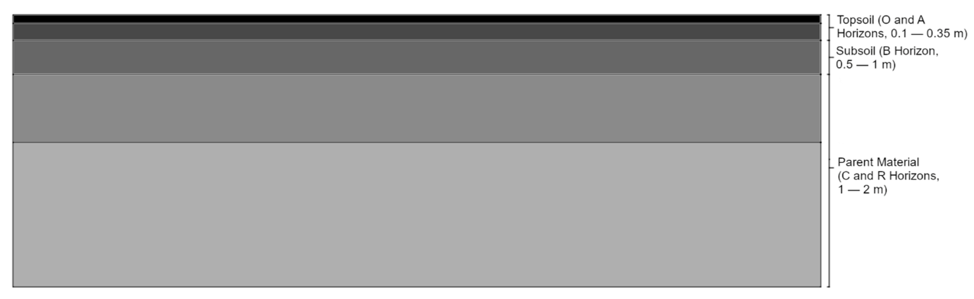
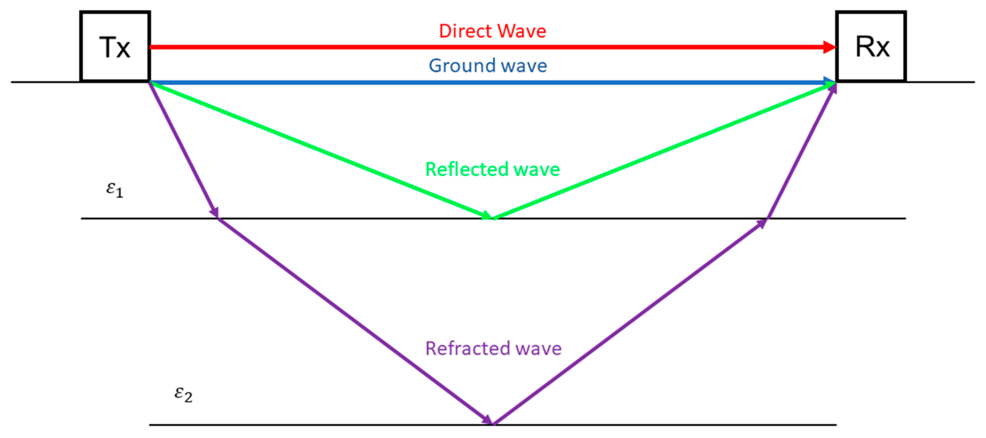
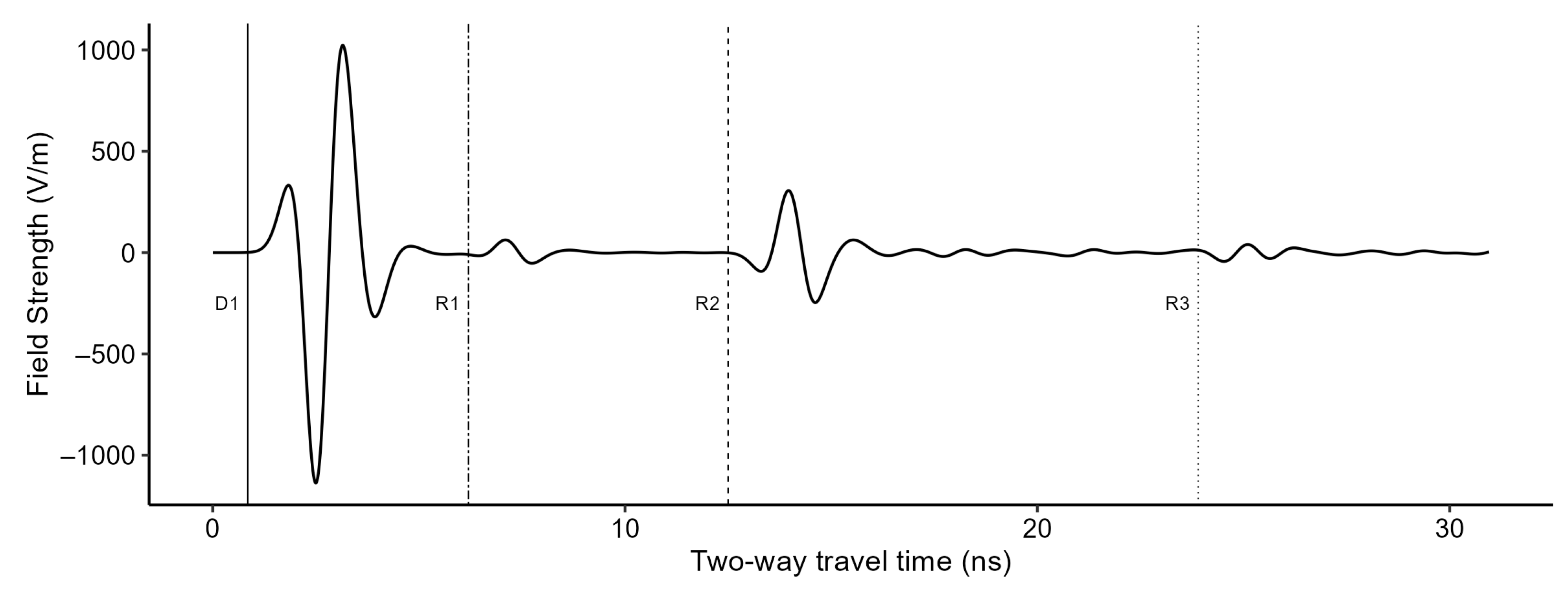
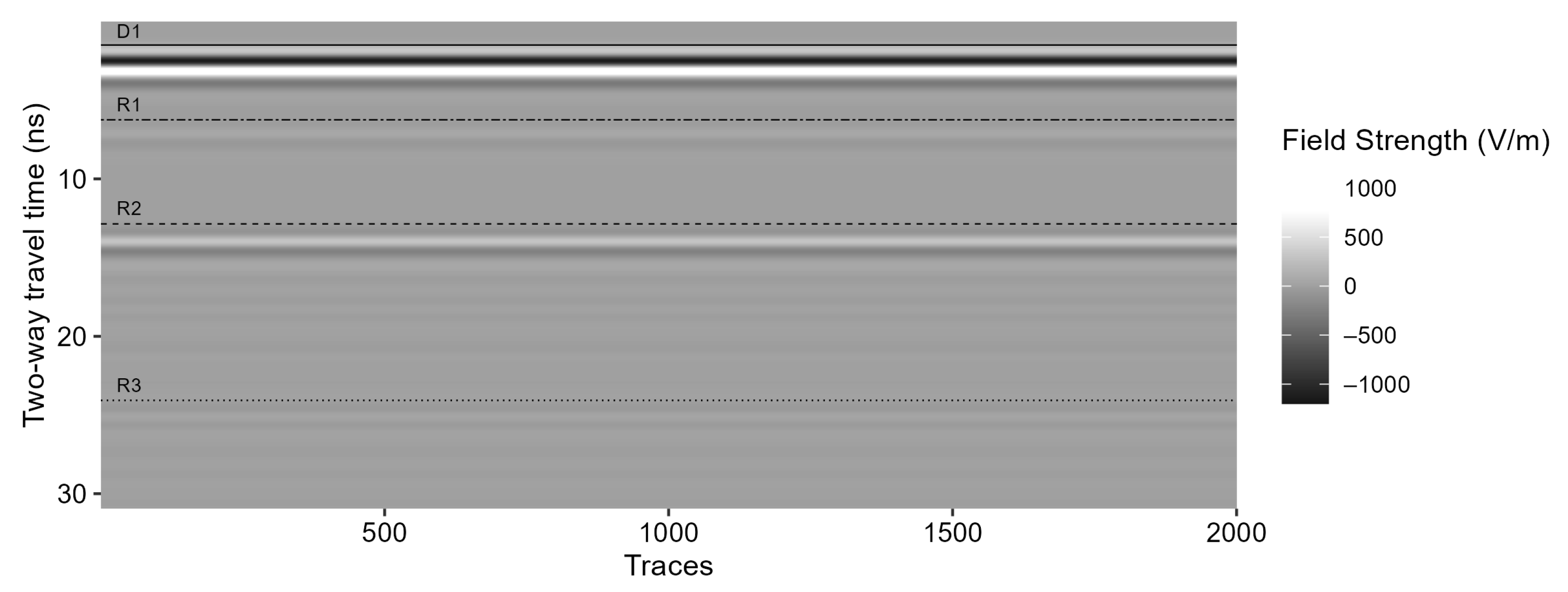

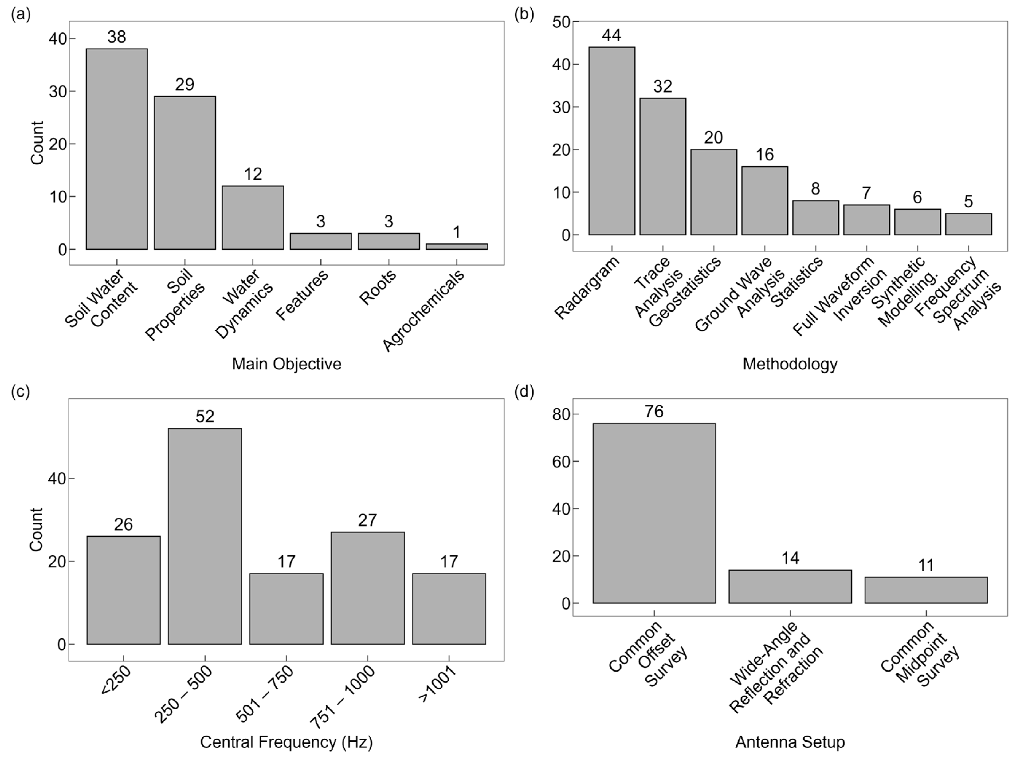
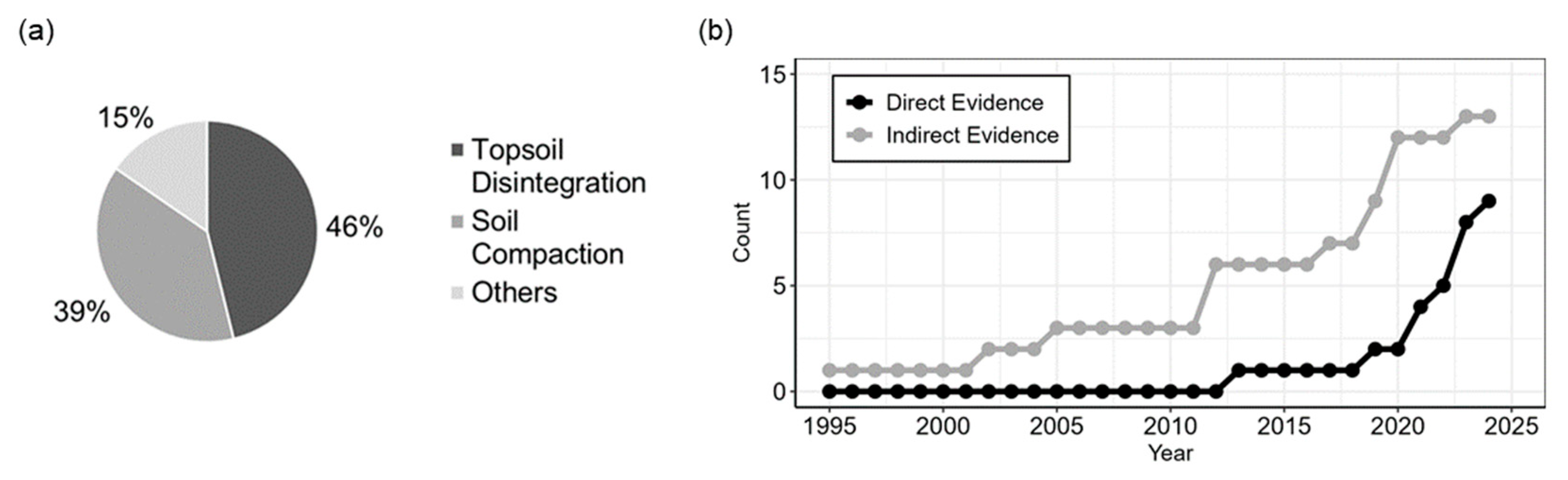
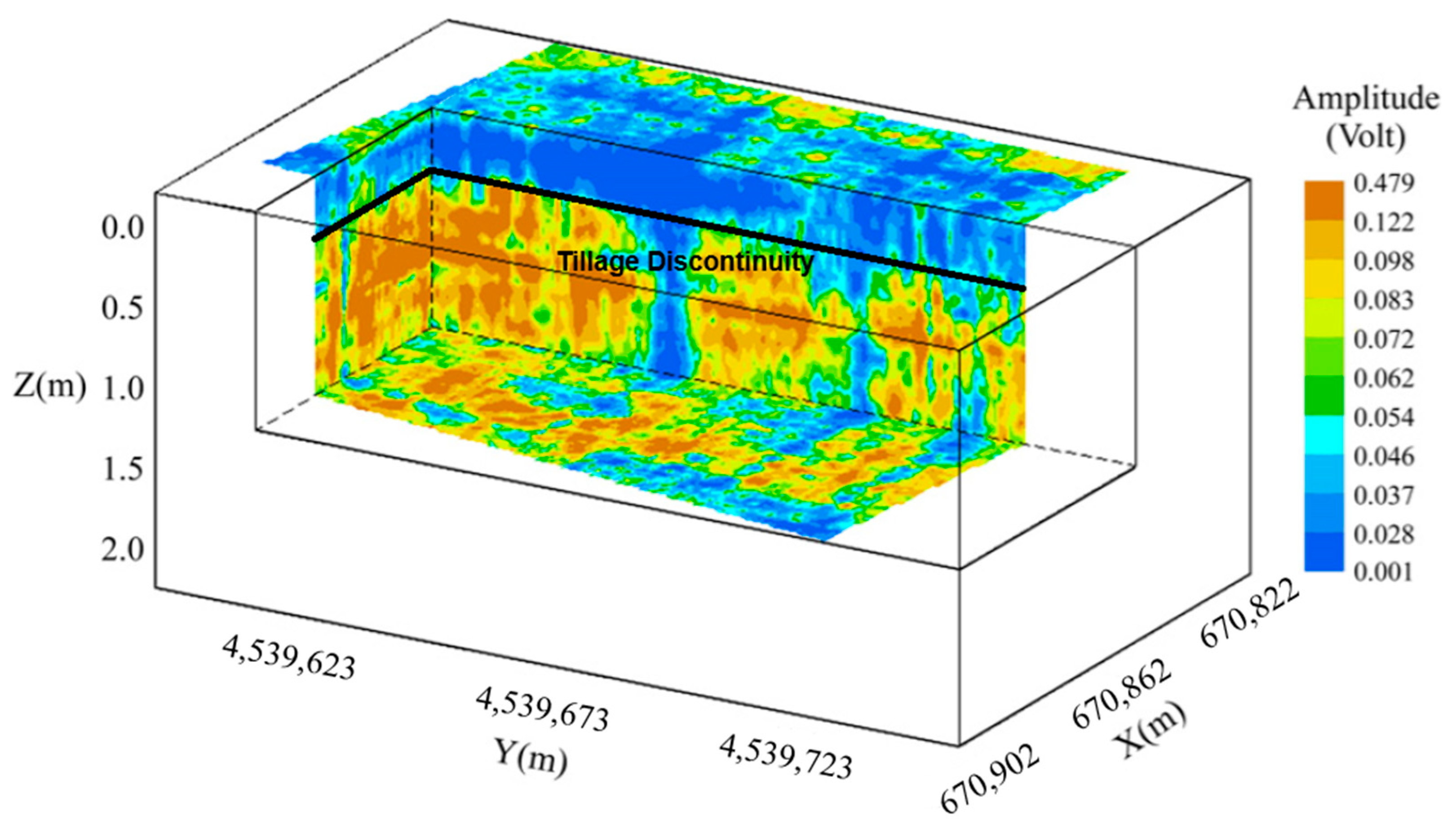
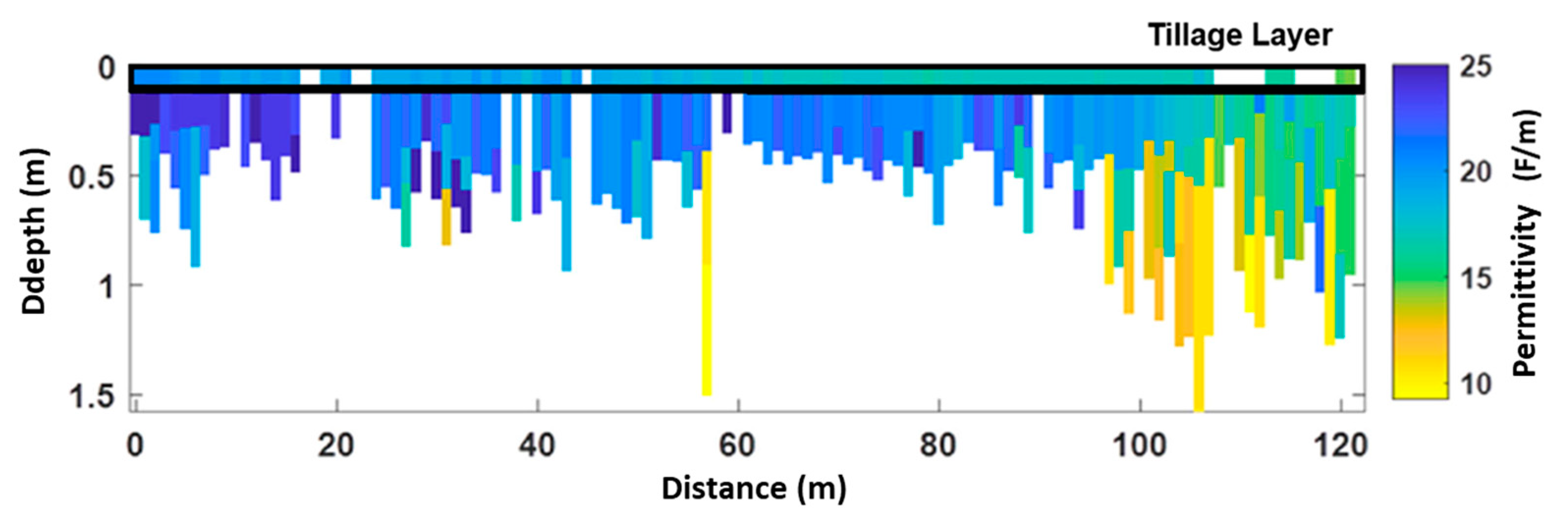
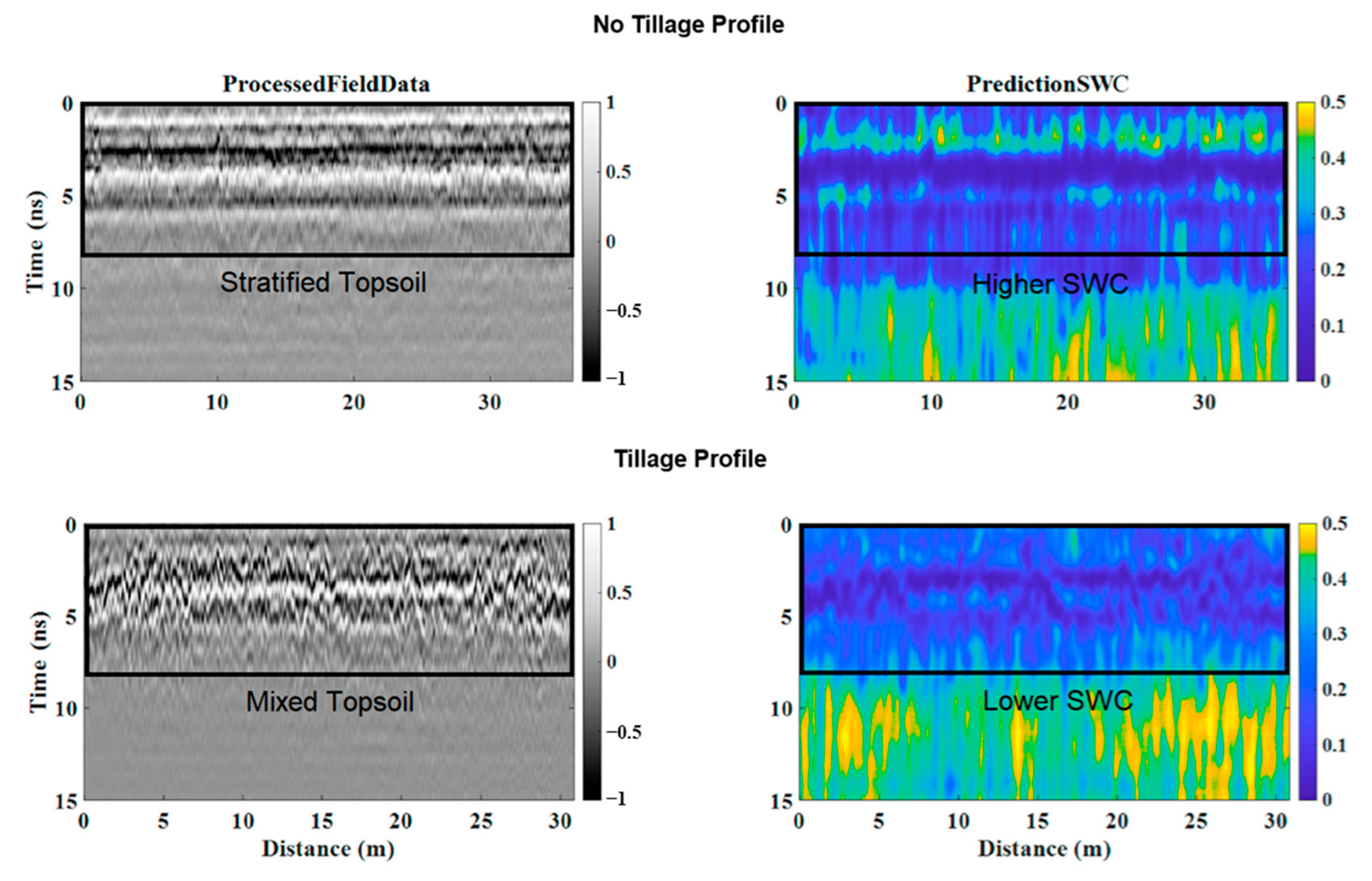
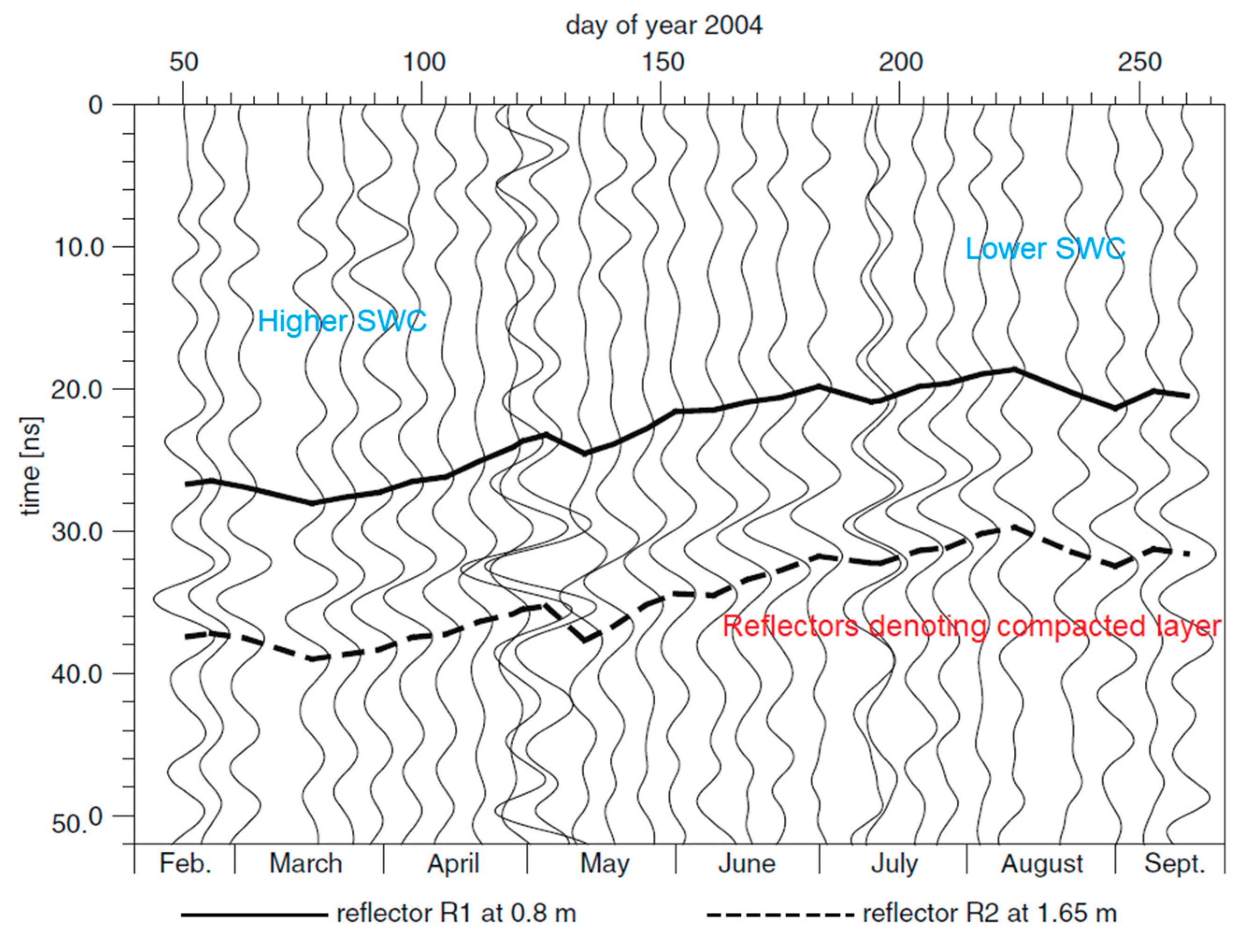
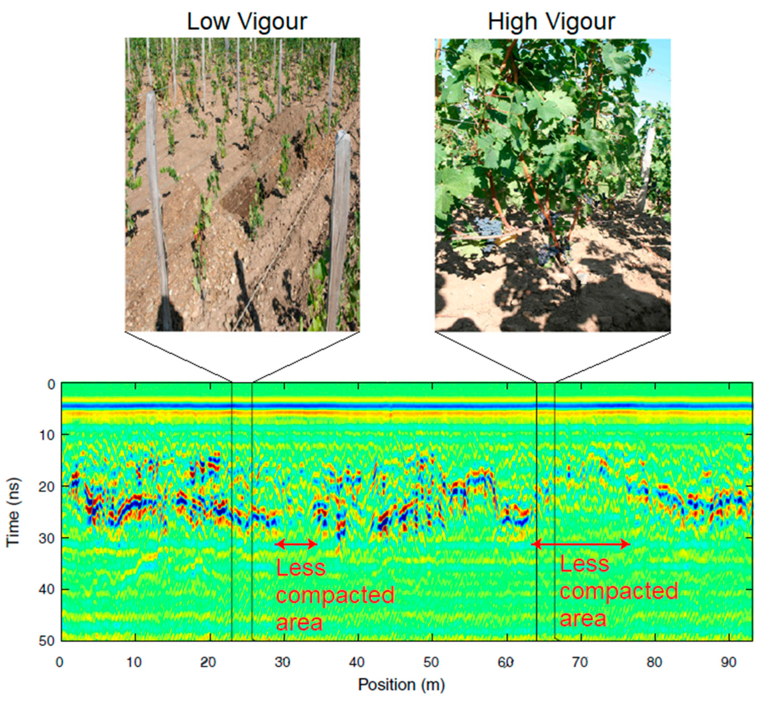
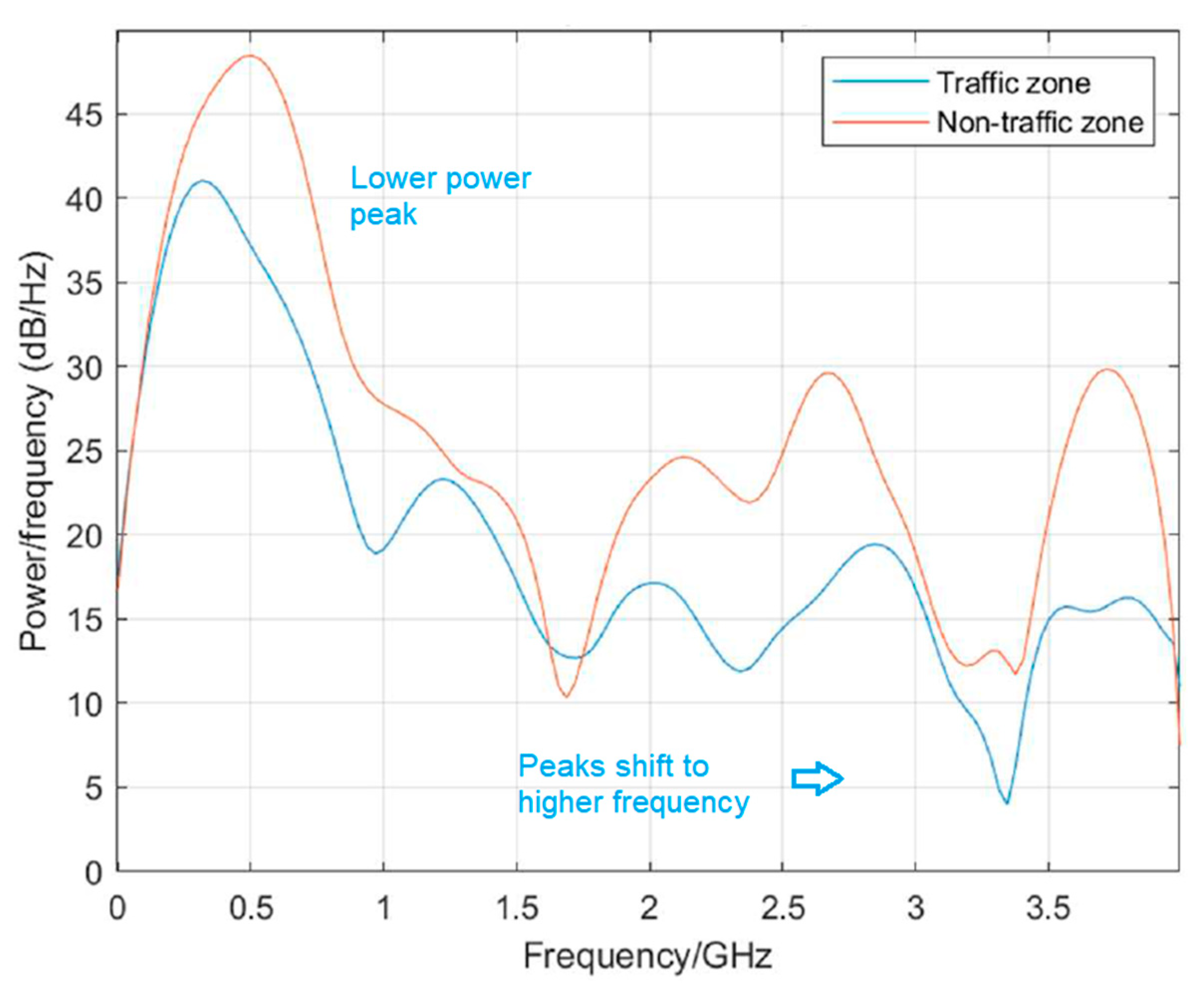


Disclaimer/Publisher’s Note: The statements, opinions and data contained in all publications are solely those of the individual author(s) and contributor(s) and not of MDPI and/or the editor(s). MDPI and/or the editor(s) disclaim responsibility for any injury to people or property resulting from any ideas, methods, instructions or products referred to in the content. |
© 2025 by the authors. Licensee MDPI, Basel, Switzerland. This article is an open access article distributed under the terms and conditions of the Creative Commons Attribution (CC BY) license (https://creativecommons.org/licenses/by/4.0/).